(2009, chapter 31) An Act respecting the boundaries of the ...
48
FIRST SESSION THIRTY-NINTH LEGISLATURE Bill 28 (2009, chapter 31) An Act respecting the boundaries of the waters in the domain of the State and the protection of wetlands along part of the Richelieu River Introduced 25 March 2009 Passage in principle 11 June 2009 Passed 18 June 2009 Assented to 19 June 2009 Québec Official Publisher 2009
Transcript of (2009, chapter 31) An Act respecting the boundaries of the ...
FIRST SESSION THIRTY-NINTH LEGISLATURE
Bill 28(2009, chapter 31)
An Act respecting the boundaries of thewaters in the domain of the State and theprotection of wetlands along part of theRichelieu River
Introduced 25 March 2009Passage in principle 11 June 2009Passed 18 June 2009Assented to 19 June 2009
Québec Official Publisher2009
EXPLANATORY NOTES
This Act determines the location of the boundaries of the watersin the domain of the State along part of the Richelieu River.
This Act is also intended to protect the River’s ecosystems bygranting protected status as a proposed biodiversity reserve to certainwetlands along the River, and introducing other measures designedto better safeguard certain zones identified as being of ecologicalinterest.
The part of the Richelieu River affected by this Act lies betweenthe Québec-U.S. border and the southern boundary of lands locatednear the Gouin bridge in the territory of Ville de Saint-Jean-sur-Richelieu. It runs through seven municipalities in the territory of theMunicipalité régionale de comté du Haut-Richelieu: Municipalitéde Lacolle, Municipalité de Henryville, Municipalité de Noyan,Municipalité de Sainte-Anne-de-Sabrevois, Municipalité de Saint-Blaise-sur-Richelieu, Ville de Saint-Jean-sur-Richelieu and Paroissede Saint-Paul-de-l’Île-aux-Noix.
LEGISLATION AMENDED BY THIS ACT :
– Act respecting administrative justice (R.S.Q., chapter J-3).

Bill 28
AN ACT RESPECTING THE BOUNDARIES OF THE WATERSIN THE DOMAIN OF THE STATE AND THE PROTECTION OFWETLANDS ALONG PART OF THE RICHELIEU RIVER
THE PARLIAMENT OF QUÉBEC ENACTS AS FOLLOWS:
CHAPTER I
OBJECTS AND SCOPE
1. This Act determines the location of the boundaries of the waters in thedomain of the State along part of the Richelieu River. In doing so it seeks toreinforce the legal status of titles of ownership along that part of the River.
The Act also seeks to ensure the protection of the River and its ecosystems.Through the boundaries chosen and the other measures set forth, the Actrecognizes the remarkable ecological interest of certain wetlands along thatpart of the River and the need to preserve them for the benefit of present andfuture generations.
2. The part of the River to which this Act applies crosses the following sevenmunicipalities situated in the Municipalité régionale de comté du Haut-Richelieu: Municipalité de Lacolle, Municipalité de Henryville, Municipalitéde Noyan, Municipalité de Sainte-Anne-de-Sabrevois, Municipalité de Saint-Blaise-sur-Richelieu, Ville de Saint-Jean-sur-Richelieu and Paroisse de Saint-Paul-de-l’Île-aux-Noix.
The part of the River in question lies between the Québec-U.S. border and,at Saint-Jean-sur-Richelieu:
(1) on the west shore, the cadastral boundaries of the city of Saint-Jean andthe parish of Saint-Jean in the registration division of Saint-Jean; and
(2) on the east shore, north of the Gouin bridge, the southern boundary oflot 643 in the cadastre of the town of Iberville in the registration division ofSaint-Jean,

4
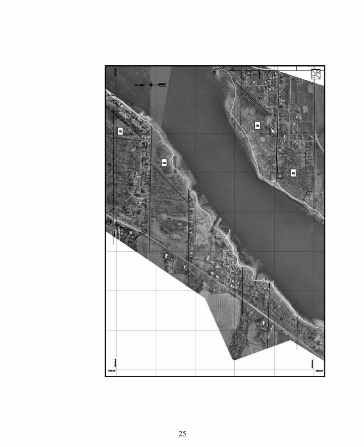
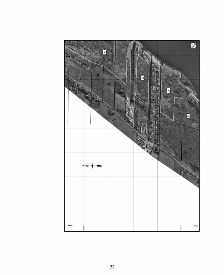
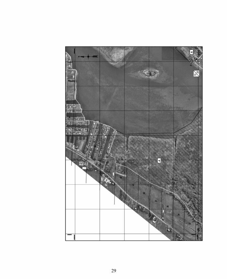
as shown on the map tabled in the National Assembly on 11 June 2009 in twoversions, one on hard copy and one containing information on a computermedium, as Sessional Paper No. 109-20090325. The same map, in bothversions, is also filed with the office of the Surveyor General of Québec.
3. If there is a discrepancy between the two versions of the map referred toin section 2, the computer version prevails. The map is reproduced, in asmaller version, in Schedule I.
The photographs that appear as a background on the map and the lotnumbering and similar information given on the map to facilitate understandingare for information purposes only and without legal value.
CHAPTER II
BOUNDARIES OF THE WATERS IN THE DOMAIN OF THE STATE
DIVISION I
LOCATION OF THE DIVIDING LINE
4. As of 19 June 2009, the boundary of the waters in the domain of the Statealong the part of the River covered by this Act is the line appearing on the mapreferred to in section 2.
The first paragraph applies despite articles 919, 965 and 966 of the CivilCode and any other general or special provision of that Code or of an Act, title,deed, judgment or other document.
5. As of 19 June 2009, a reference, for property purposes, in any Act, title,deed, judgment or other document, to the boundary of the waters in the domainof the State, to the high-water mark or to the shore of the River as a property linemust be understood as a reference, for the part of the River covered by this Act,to the boundary defined in section 4, subject to the corrections provided for insection 9 and to any alienation or other act that may affect the position of thatboundary, in accordance with the law, after 19 June 2009.
As of the same date, for the same purposes, and subject to the sameconditions, any description or representation of the boundaries of a lot orimmovable appearing in a document that exists on 19 June 2009, including acadastral plan, location certificate, or minutes of boundary determination, andthat does not already respect the line referred to in section 4, is deemed to bemodified and the boundaries described or represented, rectified as required.
6. Titles of ownership, instruments transferring authority, administration orother rights, leases, servitudes, or any other right, charge or obligation of aperson, including the State, that relate to the area extending away from theRiver, beyond the line established in section 4, and that were entered into or

5
established before 19 June 2009 may not be invalidated by sole reason of anerroneous map reference to the waters in the domain of the State.
In addition, if an acquisitive prescription may be applied in that area, theduration of possession for a period preceding 19 June 2009 may not be reducedor denied on the grounds that the land concerned was not subject to prescriptionduring that period because it was in waters in the domain of the State.
7. Legal action may not be taken against the State or any other person toclaim, directly or indirectly, a reimbursement of costs or other sums, nor toobtain any compensation, indemnity or reparation as a result or because of theeffects of this Act and the boundaries it provides for.
8. The line referred to in section 4 of this Act is not pertinent and may notbe cited in legal proceedings undertaken for or against any person, includingthe State, in order to support contentions as to the location of the high-watermark for a period preceding 19 June 2009, to determine the location of that markon a part of the River other than that covered by this Act, or to determine thelocation of that mark or of the waters in the domain of the State in relation tothe islands in the part of the River covered by this Act.
Similarly, the line referred to in section 4 is not pertinent and may not becited in legal proceedings to determine the line the waters of the River mayreach for purposes other than property purposes. In particular, it may not beused to establish water levels or flood levels when applying measures forpublic safety or when applying measures for environmental protection, includingthe identification of the limits of the land protected by the Marcel-Raymondecological reserve.
9. The Minister may, before 19 June 2011 and with the permission of theowner concerned, make minor changes to the line referred to in section 4 inorder to resolve a technical problem or locate with greater precision in the areathe boundary of the waters in the domain of the State.
A notice of any changes made must be published in the Gazette officielle duQuébec. In addition to briefly describing the changes, the notice must statewhere a person may go to examine or obtain a hard copy or a computer versionof the map with changes included. Section 3 applies, with the necessarymodifications, to any map changed in this way.
If the Minister decides to reject a request for a change or decides not toaccept the requested change as formulated, the person concerned may contestthe decision before the Administrative Tribunal of Québec within 30 days afterthe decision has been rendered.
A decision rendered by the Minister under the first paragraph with regard toa request for a change addressed to the Minister must be sent by registered mailto the person concerned. If unfavourable, the decision must state that theperson has the right to appeal before the Administrative Tribunal of Québec.

6
10. When a cadastral plan is established for an area that includes or adjoinsthe part of the River covered by this Act, the line referred to in section 4, asmodified if applicable, must be reproduced on the plan as representing theboundary of the waters in the domain of the State. The plan must be made inaccordance with this section and, more specifically, so that
(1) the boundaries of the lots concerned are redrawn in accordance with theline referred to in section 4 and do not extend beyond it toward the middle ofthe River; and
(2) any lot, other than one relating to an island, that would be situatedentirely beyond that line toward the middle of the River must be registered asbeing owned by the Gouvernement du Québec.
This section applies despite any general or special provision of an Act orother document to the contrary, including the provisions of the Act to promotethe reform of the cadastre in Québec (R.S.Q., chapter R-3.1).
11. The Minister must ensure that a copy of this Act and of both versions ofthe map referred to in section 2 is entered in the Register of the domain of theState. This may be done without further formality or procedure.
The first paragraph applies, with the necessary modifications, to any versionof the map that is changed by the Minister under section 9. Any changedversion of the map is also sent to the office of the Surveyor General of Québec.
12. With the exception of the requirements of section 11, and despite theprovisions of any general or special Act, including the Civil Code, no additionalmeasure is required to publicize the boundary set in this Act between the watersin the domain of the State and the lands along the part of the River covered bythis Act.
13. To increase awareness of the boundaries of the waters in the domain ofthe State established by this Act, the Minister sends to the registry office,on the basis of the information at the Minister’s disposal and as it becomesavailable, a notice containing the text set out in Schedule II and specifying thelots the Minister considers likely to be affected by the boundary provided for insection 4 and the names of the cadastres and registration divisions in which thelots are situated, so that the registrar may enter the notice for each lot.
The first paragraph applies, with the necessary modifications, to any changesmade to the line under section 9, in which case the text to be reproduced forthe notice is that published in the Gazette officielle du Québec under thatsection.
Subject to the fees payable for the publication of notices, it is not necessaryto follow the prescriptions of the Civil Code or its regulations regarding thepublication of rights when making these applications and entries.
7
In addition to making the information available to the public via the officeof the Surveyor General of Québec, the Minister may use any other means heor she judges appropriate to increase awareness of the boundaries of the watersin the domain of the State on the part of the River covered by this Act.
DIVISION II
COMPENSATION PAID BY THE REGIONAL COUNTYMUNICIPALITY
14. As compensation for the boundary delimitation carried out, includingcartographic work, the Municipalité régionale de comté du Haut-Richelieumust pay a sum of $725,000, of which $400,000 is paid to the fund establishedin Chapter IV, in accordance with the provisions of that chapter, and $325,000is paid to the Minister of Sustainable Development, Environment and Parksnot later than 17 September 2009. Any balance not paid to the Minister by thatdate bears interest, capitalized monthly, at the rate set under the first paragraphof section 28 of the Act respecting the Ministère du Revenu (R.S.Q.,chapter M-31).
Despite the first paragraph, the Minister and the regional county municipalitymay agree to another schedule for payments made to the Minister in order, forexample, to permit payment by instalments or to review the moment at whichan unpaid balance begins bearing interest.
15. The Municipalité régionale de comté du Haut-Richelieu may require thelocal municipalities identified in section 2 to reimburse the sums paidunder section 14.
The regional county municipality and the local municipalities concernedmust agree on the sharing criteria to be used to determine the contribution ofeach local municipality, as well as the payment schedule, the interest and theother applicable terms of payment.
If no agreement is reached, the Minister, at the request of the regionalcounty municipality or one of the local municipalities, sets the contribution ofeach local municipality, determines the payment schedule, the interest and theother applicable terms of payment, and notifies the local municipalities, aswell as the regional county municipality in writing of his or her decision. Tothis end, the Minister may take into account the linear metres of shore affectedby the boundary provided for in section 4, the use or zoning of the immovablesconcerned, or their value.
In order to finance its contribution, a local municipality may impose any taxor other method of financing at its disposal. It may, for instance, impose aspecial tax and establish to that end any criterion or distinction it judgespertinent, such as the imposition of such a tax only on taxable immovablesaffected by the boundary provided for in section 4. However, a general or

8
specific tax introduced to finance a local municipality’s contribution may notbe imposed on immovables that are adjacent to areas established as a proposedbiodiversity reserve under section 16, and that would be riverfront propertywere it not for the reserve.
CHAPTER III
PROTECTION OF THE RIVER AND ITS WETLANDS
DIVISION I
CREATION OF A PROPOSED BIODIVERSITY RESERVE
16. The area in the zones marked “A” on the map referred to insection 2 and reproduced in Schedule I is deemed to be a proposed biodiversityreserve on 19 June 2009, in accordance with Title III of the Natural HeritageConservation Act (R.S.Q., chapter C-61.01), for a period of four years beginningon that date. This proposed reserve is provisionally called the “Samuel-DeChamplain proposed biodiversity reserve”.
Not later than six months after 19 June 2009, but subject to an extensionauthorized by the Government, the Minister has the government-approvedconservation plan for the proposed reserve published in the Gazette officielle duQuébec. During the period preceding the publication of the plan, the activitiespermitted or prohibited on the proposed biodiversity reserve are those providedfor in subparagraphs 1 and 2 of the first paragraph of section 92 of the NaturalHeritage Conservation Act, with the necessary modifications.
The other provisions of that Act also apply, with the necessary modifications.For the purposes of section 42 of that Act, the date of the notice for the settingaside of a reserve is that provided for in the first paragraph.
Despite the regulations on waters in the domain of the State made under theWatercourses Act (R.S.Q., chapter R-13) and in order to ensure propermanagement of the protected area, the Minister may stipulate the conditionsunder which rights in that area may be granted or transferred.
DIVISION II
SPECIAL PROTECTION SCHEME FOR CERTAIN ZONESOF ECOLOGICAL INTEREST
17. This division applies to the zones of ecological interest marked “B” onthe map referred to in section 2 and reproduced in Schedule I.
18. In a zone of ecological interest referred to in section 17, despite anyprovision to the contrary and without restricting other requirements orauthorizations provided for in an Act or its regulations, the following activitiesmay not be carried on unless a certificate of authorization is first obtained

9
from the Minister under section 22 of the Environment Quality Act (R.S.Q.,chapter Q-2), regardless of the purpose for which they are undertaken:
(1) the removal of vegetation cover or the cutting of trees or shrubs;
(2) all land development, including filling, clearing, digging, burying andearthworks, as well as the creation, development or maintenance of awatercourse;
(3) the use, spreading or depositing, by any method whatsoever, of materialsor substances to control the presence, growth or number of plant or wildlifespecies; and
(4) the construction, erection, addition or alteration of a building, facilityor work; however, repair and maintenance of a building, facility or work arenot subject to this section unless the repairs or maintenance require authorizationunder one of the preceding paragraphs or is such as may result in a significantdisturbance of soil, water or surrounding ecosystems.
Subparagraph 2 of the first paragraph does not apply to maintenance workon a watercourse carried out in a zone of ecological interest by a municipalauthority, which remain subject to the general system set out in the EnvironmentQuality Act.
The provisions of the Environment Quality Act and its regulations onapplications for authorization and certificates of authorization apply, with thenecessary modifications, to applications for authorization and certificates ofauthorization for the activities covered by this section. Without restricting thegenerality of the foregoing, the following apply to such activities, applicationsand certificates: sections 23, 24, 106, 107, 114, 115, 119, 119.1, 122.1, 122.2and 123.1, as well as the other provisions of Divisions XI, XIII and XIV ofChapter I of that Act relating to recourse before the Administrative Tribunal ofQuébec, the penal provisions and other sanctions, as well as the generalprovisions, including those on powers of inspection.
19. In evaluating an application for authorization filed under section 22 ofthe Environment Quality Act for a project located in a zone of ecologicalinterest referred to in section 17, the Minister must take into consideration thefact that such a zone, located in the littoral zone of the River, must, inprinciple, be maintained in its natural state.
In addition and without limiting the consideration of any other relevantelement, the Minister may not issue a certificate of authorization for such aproject unless of the opinion that activities or works in the zone are justifiedby the impossibility or great difficulty of engaging in them or carrying themout elsewhere, or by the necessity or manifest interest of engaging in them orcarrying them out within the zone.

10
A certificate of authorization issued for a project in such a zone may specify,among other things, the procedures and conditions imposed by the Minister inorder to reduce the prejudicial impact of the activity or works to a minimum,given the significance and characteristics of the zone which, among otherfunctions,
(1) acts as a pollution filter, controls erosion and retains sediments, thuspreventing and reducing surface water and ground water pollution and sedimentinput;
(2) acts as a regulator of water levels by retaining meteoric water andallowing part of it to evaporate, thus reducing the risk of flood;
(3) helps preserve a rich biological diversity by providing food, protectionand habitat to the numerous plant and animal species it harbours;
(4) acts as a natural sun screen and wind-shield by maintaining vegetation,which in turn prevents excessive warming of water temperatures and protectssoils and crops from wind damage; and
(5) preserves the natural beauty of the watercourse and the countrysideassociated with it, thus contributing to the value of land in surrounding areas.
CHAPTER IV
FUND FOR THE PROTECTION, RESTORATION AND ENHANCEMENTOF THE RICHELIEU RIVER AND ITS WETLANDS
20. The Fund for the Protection, Restoration and Enhancement of theRichelieu River and its Wetlands is hereby established in the Municipalitérégionale de comté du Haut-Richelieu.
The Fund is dedicated to the financing of measures taken by the regionalcounty municipality to promote the protection, restoration and enhancementof the part of the River covered by this Act, as well as its wetlands, includingits shores and flood plain.
With the authorization of the regional county municipality and under theconditions it determines, the Fund may also be used to finance measures takenby the local municipalities identified in section 2.
The measures financed by the Fund must be aimed first and foremost atrestoring to their natural state the zones identified by the committee formedunder section 21.
21. The regional county municipality must create a committee responsiblefor advising it on any question involving the management of the Fund submittedto the committee, in particular questions as to which projects or works shouldbe financed and how such projects or works can best be carried out to ensurethe protection or restoration of ecosystems.

11
The committee may also advise the regional county municipality on thesematters on its own initiative.
22. The committee, whose members are appointed by the regional countymunicipality, comprises, aside from the representatives of the localmunicipalities identified in section 2, at least one person in each of thefollowing categories:
(1) a person with recognized expertise in the protection or restoration ofwetlands, shores, littoral zones or flood plains;
(2) a person involved with local or regional environmental protection groups;and
(3) a person chosen from among those, in the territory of the regionalcounty municipality, who are responsible for applying or enforcing urbanplanning by-laws designed to protect shores, littoral zones or flood plains.
The regional county municipality may also appoint to the committee, asnon-voting members, employees of the Ministère du Développement durable,de l’Environnement et des Parcs or the Ministère des Ressources naturelles etde la Faune, designated by those departments.
23. Sections 148.4, 148.5 and 148.7 to 148.13 of the Act respecting landuse planning and development (R.S.Q., chapter A-19.1) apply to the committee,with the necessary modifications.
24. The regional county municipality sets the date on which the Fund beginsto operate and determines its assets and liabilities and the nature of thecosts that may be charged to it.
If the regional county municipality chooses to spread payment of the initialamount provided for in paragraph 1 of section 25 over two or more instalmentsrather than pay the whole amount at the outset, it must also provide the dates orintervals of payment.
25. The Fund is made up of
(1) the sums paid into it by the regional county municipality, including aninitial amount of $400,000, and the other amounts paid into it by the localmunicipalities identified in section 2;
(2) the gifts, legacies and other contributions paid into it to further theachievement of the objects of the Fund;
(3) the sums paid into it by a Minister or a government body out of theappropriations granted for that purpose by Parliament;

12
(4) the revenues allocated to that purpose by the Government, and anycontribution determined by the Government on a proposal of the Minister ofFinance;
(5) the fines paid by those who commit an offence under an Act or regulationapplied by the regional county municipality or one of the local municipalitiesidentified in section 2, if the offence relates to the development, managementor protection of the shores, littoral zone or flood plain of the River;
(6) the fees or other amounts collected after 31 December 2009 by theregional county municipality and the local municipalities identified in section2 to compensate expenditure or reimburse costs incurred for the measures theyare authorized to take for the development, management or protection of theshores, littoral zone or flood plain of the River, such as costs and other amountsrelated to recourse taken under section 227 and following of the Act respectingland use planning and development; and
(7) the income generated by the investment of the sums making up theFund.
26. The management of the sums making up the Fund is entrusted to theMunicipalité régionale de comté du Haut-Richelieu.
The regional county municipality keeps the Fund’s books and records itsfinancial commitments. The regional county municipality also ensures thatthose commitments and the payments arising from them do not exceed and areconsistent with the available balances.
Article 203 of the Municipal Code of Québec (R.S.Q., chapter C-27.1)applies to the Fund, with the necessary modifications.
27. The fiscal year of the Fund ends on 31 December.
28. Despite paragraph 1 of section 25, if the Fund’s activities have notbegun on 19 December 2009, the regional county municipality must pay thesum of $400,000 provided for in that paragraph to the Minister of SustainableDevelopment, Environment and Parks, to be deposited in the Green Fundcreated under section 15.1 of the Act respecting the Ministère du Développementdurable, de l’Environnement et des Parcs (R.S.Q., chapter M-30.001) and usedfirst and foremost to manage and protect the wetlands and waters of theRichelieu River.
Sections 14 and 15 apply, with the necessary modifications, to the paymentof that sum by the regional county municipality.

13
CHAPTER V
AMENDING AND FINAL PROVISIONS
29. Schedule III to the Act respecting administrative justice (R.S.Q.,chapter J-3) is amended by inserting “section 9 of the Act respecting theboundaries of the waters in the domain of the State and the protection ofwetlands along part of the Richelieu River (2009, chapter 31),” after “under”in paragraph 3.
30. The Minister of Sustainable Development, Environment and Parks mustexamine without delay any draft management plan under the protection policyfor riverbanks, littoral zones and floodplains that is presented to the Ministerfor the area covered by this Act.
As portions of the plan come in, the Minister, without prejudging the finaldecision, must inform the authority concerned and any interested departmentof the result of the Minister’s summary assessment of the admissibility of eachportion of the plan.
31. The Minister of Sustainable Development, Environment and Parks isresponsible for the administration of this Act.
32. This Act applies to the Government, its ministers, and bodies that aremandataries of the State.
33. This Act comes into force on 19 June 2009.

14
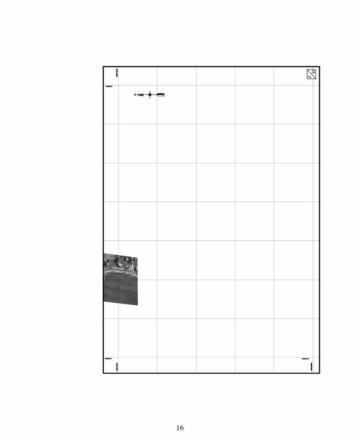
SCHEDULE I(Section 3)
Samuel De Champ ain proposed
b od versity reserve (provisional name)

15
16

17

18

19

20

21

22

23

24
25

26
27

28
29

30

31

32

33

34

35

36

37

38

39

40

41

42

43

44

45

46

47
48
SCHEDULE II(Section 13)
Notice
The Act respecting the boundaries of the waters in the domain of the Stateand the protection of wetlands along part of the Richelieu River (2009,chapter 31) determines the boundaries of the waters in the domain of the Statealong certain parts of the Richelieu River. Its provisions may apply in particularto the lots mentioned below. Under the Act, the boundaries of the lots may havechanged on or after 19 June 2009. It is therefore important to consult the Act,in particular section 4 and the map it refers to.


![1991 Bill C-19 c. 46 An Act Respecting Banks & Banking - [Canada]](https://static.fdocuments.in/doc/165x107/563db7bb550346aa9a8d6cf1/1991-bill-c-19-c-46-an-act-respecting-banks-banking-canada.jpg)