2008 Quick Guide - Texas Water Development Board · 2008. Quick Guide. Floodplain Management in...
68
Texas Floodplain Management Association http://www.tfma.org 2008 Quick Guide Floodplain Management in Texas
Transcript of 2008 Quick Guide - Texas Water Development Board · 2008. Quick Guide. Floodplain Management in...

Texas Floodplain Management Associationhttp://www.tfma.org
2008
Quick GuideFloodplain Management in Texas

This Quick Guide was originally prepared in 2002 by:
www.rcquinnconsulting.com

iTexas Quick Guide
Contents
About This Guide . . . . . . . . . . . . . . . . . . . . . . . . . . . . . . . . . . . .1
Introduction . . . . . . . . . . . . . . . . . . . . . . . . . . . . . . . . . . . . . . . .2
Texas Flood Events . . . . . . . . . . . . . . . . . . . . . . . . . . . . . . . . . . .3
Why Do We Regulate the Floodplain? . . . . . . . . . . . . . . . . . . . . .4
What is the National Flood Insurance Program? . . . . . . . . . . . . .5
Flood Insurance: Property Owner’s Best Protection . . . . . . . . . . . .6
Community Responsibilities . . . . . . . . . . . . . . . . . . . . . . . . . . . . .7
Looking for Floodplain Information? . . . . . . . . . . . . . . . . . . . . . . .8
FEMA Flood Maps Online . . . . . . . . . . . . . . . . . . . . . . . . . . . . . .9
Flood Map Modernization . . . . . . . . . . . . . . . . . . . . . . . . . . . .10
Understanding the Riverine Floodplain . . . . . . . . . . . . . . . . . . . .11
Understanding the Floodway . . . . . . . . . . . . . . . . . . . . . . . . . . .12
Flood Maps . . . . . . . . . . . . . . . . . . . . . . . . . . . . . . . . . . . . . .13
The Flood Boundary and Floodway Map (Riverine) . . . . . . . . . .14
Old Format Flood Insurance Rate Map (Riverine) . . . . . . . . . . . .15
Flood Insurance Rate Map (Riverine) . . . . . . . . . . . . . . . . . . . . .16
Use the Riverine Flood Profile to Determine BFEs . . . . . . . . . . . . .17
Approximate Flood Zones or Unnumbered A Zones . . . . . . . . . .18
Understanding the Coastal Floodplain . . . . . . . . . . . . . . . . . . . .19
Flood Insurance Rate Map (Coastal) . . . . . . . . . . . . . . . . . . . . .20
Areas of Shallow Flooding . . . . . . . . . . . . . . . . . . . . . . . . . . . .21
Changes to FEMA Flood Maps . . . . . . . . . . . . . . . . . . . . . . . . .22
Activities Requiring Permits . . . . . . . . . . . . . . . . . . . . . . . . . . . .23
Safe Uses of the Floodplain . . . . . . . . . . . . . . . . . . . . . . . . . . . .24
Is Your Building Site Higher than the BFE? . . . . . . . . . . . . . . . . .25
What is Meant by Pre-FIRM and Post-FIRM? . . . . . . . . . . . . . . . .26
Nature Doesn’t Read Maps . . . . . . . . . . . . . . . . . . . . . . . . . . . .27
Think Carefully Before You Seek a Variance . . . . . . . . . . . . . . . .28
Some Key Permit Review Steps . . . . . . . . . . . . . . . . . . . . . . . . .29
Carefully Complete the Permit Application . . . . . . . . . . . . . . . . .30
Freeboard: Build Above the BFE . . . . . . . . . . . . . . . . . . . . . . . .31
What is the Elevation Certificate and How is it Used? . . . . . . . . .32
Completing the Elevation Certificate . . . . . . . . . . . . . . . . . . . . . .33
Paperwork is Important – for You and Your Community . . . . . . . .34
Floodplain Fill Can Make Things Worse . . . . . . . . . . . . . . . . . . .35
Recommended Floodway “No Rise” Certification . . . . . . . . . . . .36
How to Elevate Your Floodplain Building (Riverine) . . . . . . . . . . .37
Compaction of Floodplain Fill (A Zone) . . . . . . . . . . . . . . . . . . .38
Basements are Unsafe . . . . . . . . . . . . . . . . . . . . . . . . . . . . . . . .39
Manufactured Homes Deserve Special Attention . . . . . . . . . . . . .40
Enclosures Below the BFE (Riverine) . . . . . . . . . . . . . . . . . . . . . .41
Typical Elevation Methods for Coastal Buildings . . . . . . . . . . . . .42

ii Texas Quick Guide
Coastal Houses Must Resist Wind and Water Forces . . . . . . . . . .43
Enclosures Below V Zone Building . . . . . . . . . . . . . . . . . . . . . . .44
The V Zone Certificate (Sample) . . . . . . . . . . . . . . . . . . . . . . . .45
Utility Service Outside Buildings . . . . . . . . . . . . . . . . . . . . . . . .46
Utility Service Inside Enclosures . . . . . . . . . . . . . . . . . . . . . . . . .47
Accessory (Appurtenant) Structures . . . . . . . . . . . . . . . . . . . . . .48
Recreational Vehicles . . . . . . . . . . . . . . . . . . . . . . . . . . . . . . . .49
Planning to Improve Your Floodplain Building? . . . . . . . . . . . . . .50
What About After Damages? . . . . . . . . . . . . . . . . . . . . . . . . . .51
Elevating a Pre-FIRM Building . . . . . . . . . . . . . . . . . . . . . . . . . .52
Some Flood Protection for Older Homes is Easy and Low Cost . . .53
Small Levees and Floodwalls Can Protect Some Older Homes . . .54
Some Flood Mitigation Projects are More Costly but Give You More Protection . . . . . . . . . . . . . . . . . . . . . . . . . .55
Be Flood Safe – Don’t Drive Through Flooded Roads . . . . . . . . . .56
Useful Web Sites and Common Acronyms . . . . . . . . . . . . . . . . .57
Resources . . . . . . . . . . . . . . . . . . . . . . . . . . . . . . . . . . . . . . . .58
Contents, continued
1Texas Quick Guide
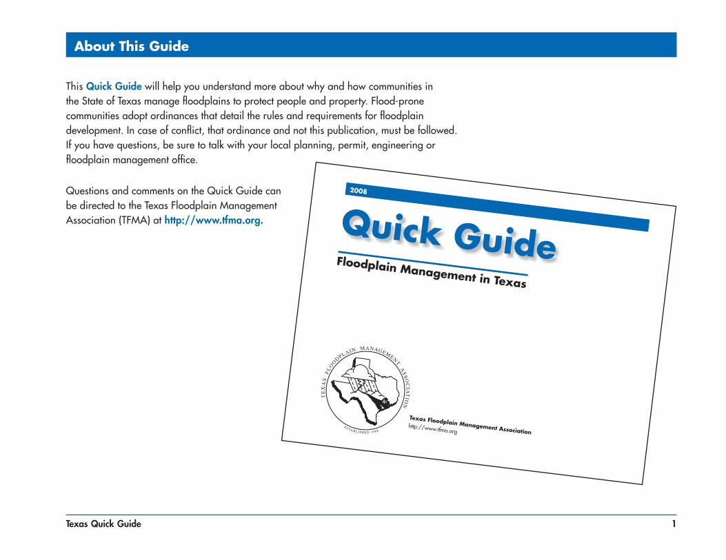
About This Guide
Texas Floodplain Management Associationhttp://www.tfma.org
2008
Quick GuideFloodplain Management in Texas
This Quick Guide will help you understand more about why and how communities in the State of Texas manage floodplains to protect people and property. Flood-prone communities adopt ordinances that detail the rules and requirements for floodplain development. In case of conflict, that ordinance and not this publication, must be followed. If you have questions, be sure to talk with your local planning, permit, engineering or floodplain management office.
Questions and comments on the Quick Guide can be directed to the Texas Floodplain Management Association (TFMA) at http://www.tfma.org.
2 Texas Quick Guide
The Texas Floodplain Management Association (TFMA) and its partners are pleased to provide this Quick Guide to help citizens understand what floodplain management is and why floodplain development is regulated.
Communities regulate the floodplain to:
■ Protect people and property
■ Ensure that Federal flood insurance and disaster assistance are available
■ Save tax dollars
■ Reduce future flood losses
■ Reduce liability
Floods have been, and continue to be, the most destructive natural disaster in terms of economic loss to the citizens of Texas. More than 12% of the state’s land area is subject to flooding. Since 1978, Texas flood insurance policy holders have filed over 178,000 flood loss claims totalling $2.9 billion in claim payments. Even though that represents many insurance payments, most flood-prone Texans don’t have flood insurance.
Introduction

3Texas Quick Guide
■ Flood-prone areas have been identified in most counties, cities and towns in Texas.
■ Millions of structures are located in mapped flood-prone areas.
■ Since 1988, over 400 people have died in flood-related incidents and over $4 billion in damage has occurred.
■ About 12% of the state’s land area is mapped floodplain. Many waterways have not been mapped.
Not all flood events are declared major disasters. Many floods are local, affecting only small areas or a few watersheds.
Texas Flood Events
Presidential Disaster Declarations1964-2007
3 - 5
6 - 7
8 - 10
11 - 14
15 - 18
Number of Declarationsby County
* FEMA data current to September 2007
*

4 Texas Quick Guide
■ To protect people and property. Floodplain management is about developing smart. It makes good sense. If we know part of our land will flood from time to time, we should make reasonable decisions to help protect our families, homes, and businesses.
■ To make sure that federal flood insurance and disaster assistance are available. You are not eligible to purchase flood insurance unless you are in a community that regulates development in the floodplain through the NFIP. In addition, if federal flood insurance isn’t available, then you can’t get some types of federal financial assistance. Home mortgages will be hard to find, and you won’t be able to get some types of state and federal loans and grants.
■ To save tax dollars. Every flood disaster affects your community’s budget. If we build smarter, we’ll have fewer problems the next time it floods. Remember, federal disaster assistance isn’t available for all floods. And even when the President declares a disaster, you and your community still have to pay a portion of the costs of evacuation, temporary housing, repair, and clean-up.
■ To avoid liability and law suits. If we know an area is mapped as floodplain and likely to flood, if we know people could be in danger, and if we know that buildings could be damaged, it makes sense to take reasonable protective steps when we develop and build.
■ To reduce future flood losses in Texas. Development that complies with the minimum floodplain management requirements is better protected against major flood-related damage. State legislation was amended in 1999 to require all cities and counties to adopt ordinances or orders to become eligible to participate in the NFIP. Communities in Texas also have authority to regulate development with stricter local floodplain management requirements.
Why Do We Regulate the Floodplain?
5Texas Quick Guide
The National Flood Insurance Program (NFIP) was created by Congress in 1968 to protect lives and property and to reduce the financial burden of providing disaster assistance. The NFIP is administered by the Federal Emergency Management Agency (FEMA).
The NFIP is based on a mutual agreement between the Federal Government and communities. Communities that participate agree to regulate floodplain development according to certain criteria and standards. The partnership involves:
■ Flood hazard maps. FEMA prepares maps that are used by communities, insurance agents and others.
■ Flood insurance. Property owners in participating communities are eligible to purchase federal flood insurance for buildings and contents.
■ Regulations. Communities must agree to adopt and enforce floodplain management regulations so that development, including buildings, is undertaken in ways that reduce exposure to flooding.
To learn more about the NFIP, including your potential flood risk and the approximate cost of a flood insurance policy, go to FEMA’s FloodSmart Web site at http://www.floodsmart.gov.
What is the National Flood Insurance Program?

6 Texas Quick Guide
Flood Insurance: Property Owner’s Best Protection
Who needs flood insurance? EVERYONE. Every homeowner, business owner, and renter in Texas communities that participate in the National Flood Insurance Program may purchase a flood insurance policy — regardless of the location of the building. A typical homeowners insurance policy does not cover flood insurance.
Unfortunately, it’s often after a flood that many people discover that their homeowner or business property insurance policies do not cover flood damages. Approximately 25% of all flood damages occur in low risk zones, commonly described as being “outside the mapped flood zone.”
The Texas Floodplain Management Association and the State of Texas urge YOU to protect your financial future by getting a flood insurance policy. To purchase a policy, call your insurance agent. To get the name of an agent in your community, call the NFIP’s toll free number 1 (888) 379-9531 or go to www.floodsmart.gov.
Being prepared by having flood insurance will save you money. For a $50,000 loan at 4% interest, you will pay around $3,000 per year for 30 years. Compare that to a $100,000 flood insurance premium, which is about $700 per year. If your property is in a low risk zone, your premium may be as low as $112 per year, including coverage for your property’s contents.

7Texas Quick Guide
Community Responsibilities
To participate in the National Flood Insurance Program, your community agrees to:
■ Adopt and enforce a flood damage prevention ordinance
■ Require permits for all types of development in the floodplain (see page 23)
■ Ensure that building sites are reasonably safe from flooding
■ Estimate flood elevations that were not determined by FEMA
■ Require new or substantially improved homes and manufactured homes to be elevated above the Base Flood Elevation (BFE)
■ Require other buildings to be elevated or floodproofed
■ Conduct field inspections and cite violations
■ Require Elevation Certificates to document compliance (see pages 32 through 34)
■ Carefully consider requests for variances
■ Resolve non-compliance and violations
■ Advise FEMA when updates to flood maps are needed
8 Texas Quick Guide
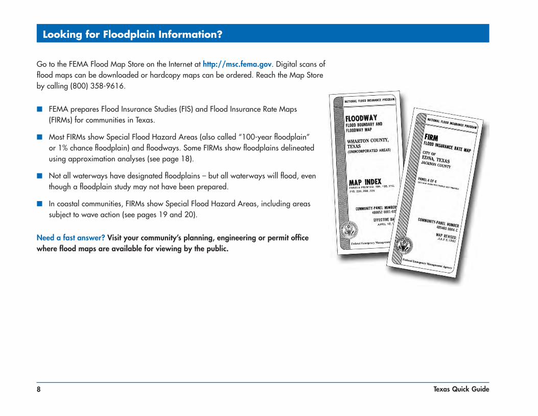
Looking for Floodplain Information?
Go to the FEMA Flood Map Store on the Internet at http://msc.fema.gov. Digital scans of flood maps can be downloaded or hardcopy maps can be ordered. Reach the Map Store by calling (800) 358-9616.
■ FEMA prepares Flood Insurance Studies (FIS) and Flood Insurance Rate Maps (FIRMs) for communities in Texas.
■ Most FIRMs show Special Flood Hazard Areas (also called “100-year floodplain” or 1% chance floodplain) and floodways. Some FIRMs show floodplains delineated using approximation analyses (see page 18).
■ Not all waterways have designated floodplains – but all waterways will flood, even though a floodplain study may not have been prepared.
■ In coastal communities, FIRMs show Special Flood Hazard Areas, including areas subject to wave action (see pages 19 and 20).
Need a fast answer? Visit your community’s planning, engineering or permit office where flood maps are available for viewing by the public.

9Texas Quick Guide
FEMA Flood Maps Online
You can find and print a FIRM by using online tools at http://msc.fema.gov.
■ Click the “View” button to display the map panel.
■ Once you find your map, use the pan and zoom tools to find the specific area of interest – a miniature map on the left side of the screen shows a red box around the area you are viewing.
■ Click the “Make a FIRMette” button and drag the pink translucent box over the area you wish to print.
■ Select paper size and Adobe Acrobat (pdf) or Image File (tif).
■ Your FIRMette will be displayed and you can print or save the file to your hard drive.
You can also order paper maps or digital maps on CD-ROM from FEMA’s Map Service Center at http://msc.fema.gov or (800) 358-9616.
10 Texas Quick Guide
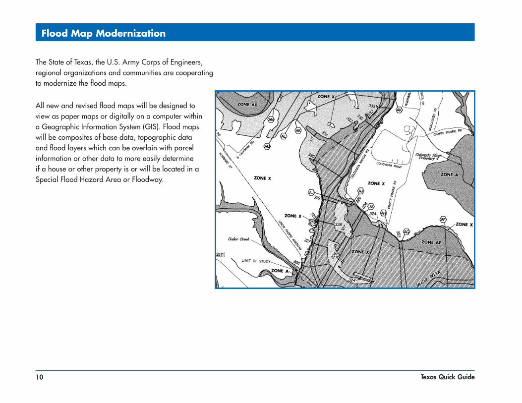
Flood Map Modernization
The State of Texas, the U.S. Army Corps of Engineers, regional organizations and communities are cooperating to modernize the flood maps.
All new and revised flood maps will be designed to view as paper maps or digitally on a computer within a Geographic Information System (GIS). Flood maps will be composites of base data, topographic data and flood layers which can be overlain with parcel information or other data to more easily determine if a house or other property is or will be located in a Special Flood Hazard Area or Floodway.
11Texas Quick Guide
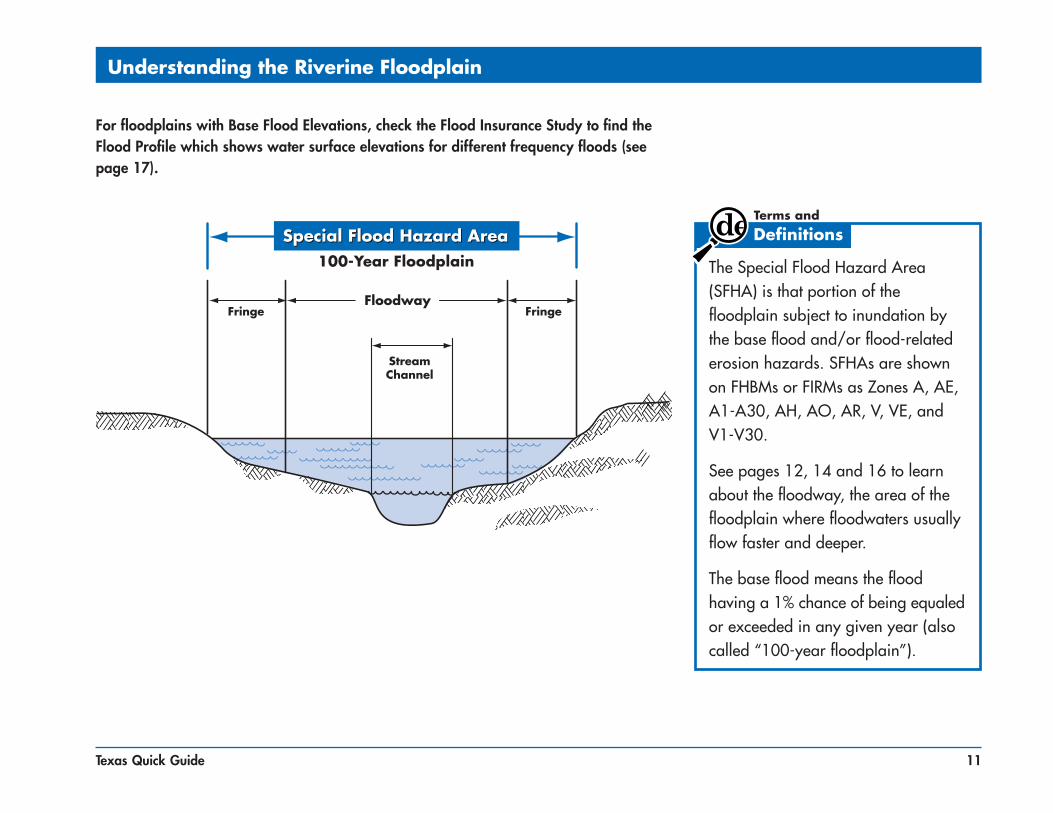
Understanding the Riverine Floodplain
The Special Flood Hazard Area (SFHA) is that portion of the floodplain subject to inundation by the base flood and/or flood-related erosion hazards. SFHAs are shown on FHBMs or FIRMs as Zones A, AE, A1-A30, AH, AO, AR, V, VE, and V1-V30.
See pages 12, 14 and 16 to learn about the floodway, the area of the floodplain where floodwaters usually flow faster and deeper.
The base flood means the flood having a 1% chance of being equaled or exceeded in any given year (also called “100-year floodplain”).
For floodplains with Base Flood Elevations, check the Flood Insurance Study to find the Flood Profile which shows water surface elevations for different frequency floods (see page 17).

12 Texas Quick Guide
For any proposed floodway development, before a local floodplain permit can be issued, the applicant must provide evidence that “no rise” will occur (see page 36). You will need a qualified registered engineer to make sure your proposed project won’t increase flooding on other properties.
Understanding the Floodway
The Floodway is the channel of a river or other watercourse and the adjacent land areas that must be reserved in order to pass the base flood discharge without increasing flood depths.
Computer models of the floodplain are used to simulate “encroachment” or fill in the flood fringe in order to predict where and how much the base flood elevation would increase if the floodplain is allowed to be filled.
13Texas Quick Guide
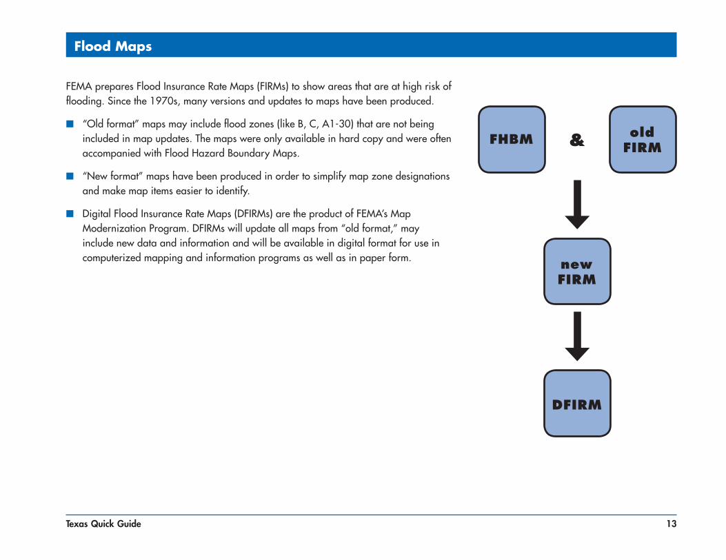
FEMA prepares Flood Insurance Rate Maps (FIRMs) to show areas that are at high risk of flooding. Since the 1970s, many versions and updates to maps have been produced.
■ “Old format” maps may include flood zones (like B, C, A1-30) that are not being included in map updates. The maps were only available in hard copy and were often accompanied with Flood Hazard Boundary Maps.
■ “New format” maps have been produced in order to simplify map zone designations and make map items easier to identify.
■ Digital Flood Insurance Rate Maps (DFIRMs) are the product of FEMA’s Map Modernization Program. DFIRMs will update all maps from “old format,” may include new data and information and will be available in digital format for use in computerized mapping and information programs as well as in paper form.
Flood Maps
FHBM old FIRM
new FIRM
DFIRM
&
14 Texas Quick Guide
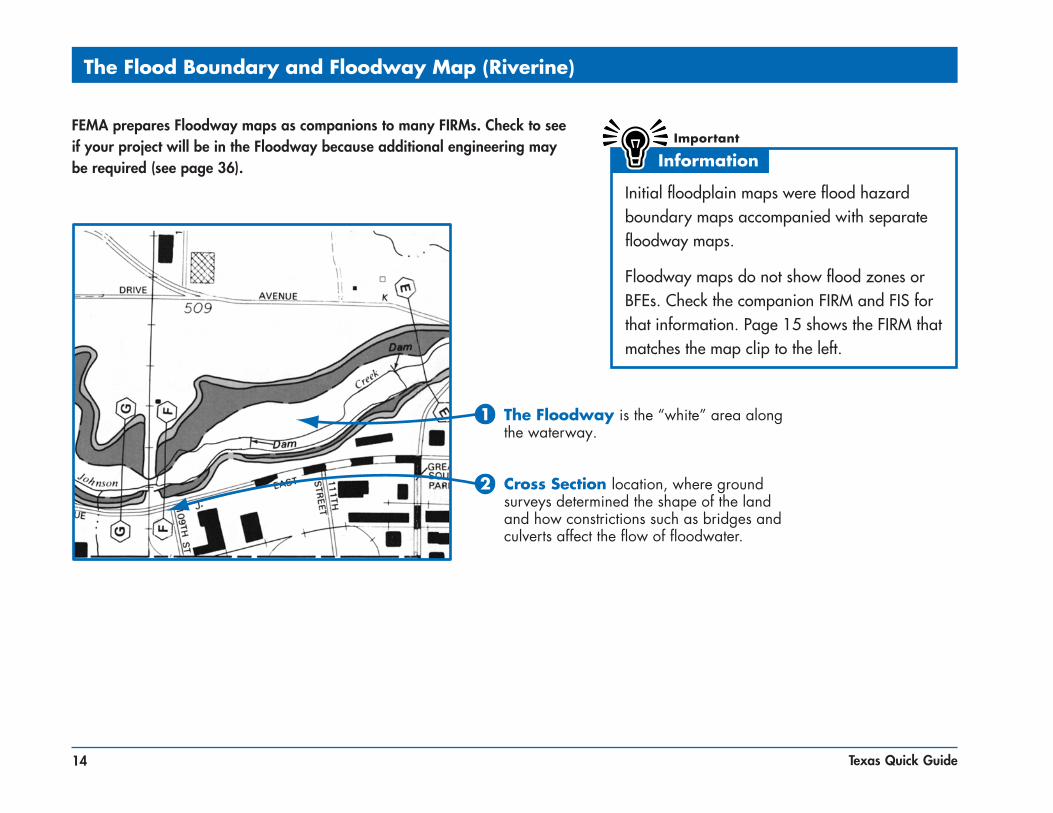
The Flood Boundary and Floodway Map (Riverine)
FEMA prepares Floodway maps as companions to many FIRMs. Check to see if your project will be in the Floodway because additional engineering may be required (see page 36).
Initial floodplain maps were flood hazard boundary maps accompanied with separate floodway maps.
Floodway maps do not show flood zones or BFEs. Check the companion FIRM and FIS for that information. Page 15 shows the FIRM that matches the map clip to the left.

15Texas Quick Guide
Old Format Flood Insurance Rate Map (Riverine)
FEMA prepares Flood Insurance Rate Maps (FIRMs) to show areas that are at high risk of flooding. These are being updated through FEMA’s Map Modernization Program.

16 Texas Quick Guide
Flood Insurance Rate Map (Riverine)

17Texas Quick Guide
Use the Riverine Flood Profile to Determine BFEs
Flood profiles can be used to determine the BFE at a specific site. Profiles also show estimated water surface elevations for floods other than the 1% annual chance flood (100-year flood.)
On the effective flood map, locate your site by measuring the distance, along the center line of the stream channel, from a road or cross section, for example, or .
Scale that distance on the Flood Profile and read up to the profile of interest, then across to determine the elevation.
1
1
21
2
18 Texas Quick Guide
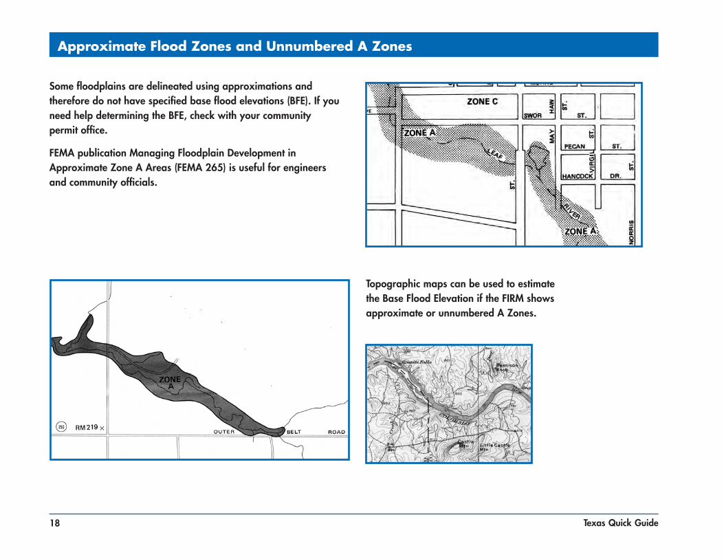
Approximate Flood Zones and Unnumbered A Zones
Some floodplains are delineated using approximations and therefore do not have specified base flood elevations (BFE). If you need help determining the BFE, check with your community permit office.
FEMA publication Managing Floodplain Development in Approximate Zone A Areas (FEMA 265) is useful for engineers and community officials.
Topographic maps can be used to estimate the Base Flood Elevation if the FIRM shows approximate or unnumbered A Zones.

19Texas Quick Guide
Understanding the Coastal Floodplain
The Coastal High Hazard Area (V Zone) is the Special Flood Hazard Area that extends from offshore to the inland limit of a primary frontal dune along an open coast and any other area subject to high velocity wave action. The area is designated on the FIRM as Zone V1-V30, VE, or V.
The term Coastal A Zone means the portion of the SFHA landward of the V Zone or landward of a shoreline that does not have a mapped V Zone. The principal sources of flooding are associated with astronomical tides, storm surges, seiches or tsunamis. Coastal A Zones may be subject to wave effects, velocity flows, erosion, scour, or combinations of these forces and may be treated as V Zones.
Coastal graphics from Coastal Construction Manual (FEMA 55CD).

20 Texas Quick Guide
UNDEVELOPED COASTAL BARRIERS
Identified1983
Identified1990
OtherwiseProtected
Areas
Flood Insurance Rate Map (Coastal)
This portion of a FIRM shows a coastal Special Flood Hazard Area (SFHA) (dark gray), the 500-year flood hazard area (light gray), coastal Base Flood Elevations (BFEs) (numbers in parentheses), and flood insurance rate zones (AE and VE = SFHA, VE = Coastal High Hazard Area, X = areas outside the SFHA).
In undeveloped Coastal Barrier Resource Areas (COBRA), NFIP insurance is not available for new or substantially improved structures built after November 16, 1990.

21Texas Quick Guide
Areas of Shallow Flooding
These are areas with a 1% chance of a shallow flood (1-3 feet) each year.
■ Zone AH areas usually flood from ponding in which water is generally not moving across the land.
■ Zone AO areas usually flood from sheet flow in which water moves across land where there is no defined channel.

22 Texas Quick Guide
Most changes to FIRMs are made by Letter of Map Change (LOMC) – a letter which reflects an official revision to an effective NFIP map.
1. Letter of Map Amendment (LOMA) is an official amendment to an effective FIRM that may be issued when a property owner provides additional technical information from a licensed land surveyor or engineer, such as ground elevation relative to the BFE, SFHA, and the building. Lenders may waive the flood insurance requirement if the LOMA documents that a building is on ground above mapped floodplain.
2. Electronic Letter of Map Amendment (eLOMA) is web based application to submit simple LOMAs to FEMA.
3. Letter of Map Revision (LOMR) is an official revision to an effective FIRM that may be issued to change flood insurance risk zones, special flood hazard area and floodway boundary delineations, BFEs and/or other map features. Lenders may waive the insurance requirement if the approved map revision shows buildings to be outside of the SFHA.
4. Letter of Map Revision Based on Fill (LOMR-F) is an official revision to an effective FIRM that is issued to document FEMA’s determination that a structure or parcel of land has been elevated by fill above the BFE, and therefore is no longer in the SFHA. Lenders may waive the insurance requirement if the LOMR-F shows that a building on fill is above the BFE.
Physical Map Revision may be issued for major floodplain changes that require engineering analyses, such as bridges, culverts, channel changes, flood control measures, and large fills that change the BFE or Floodway. Physical map revisions are also issued when a new study updates or improves the FIRM.
Requests for map revisions must be coordinated through your community.
Changes to FEMA Flood Maps
23Texas Quick Guide
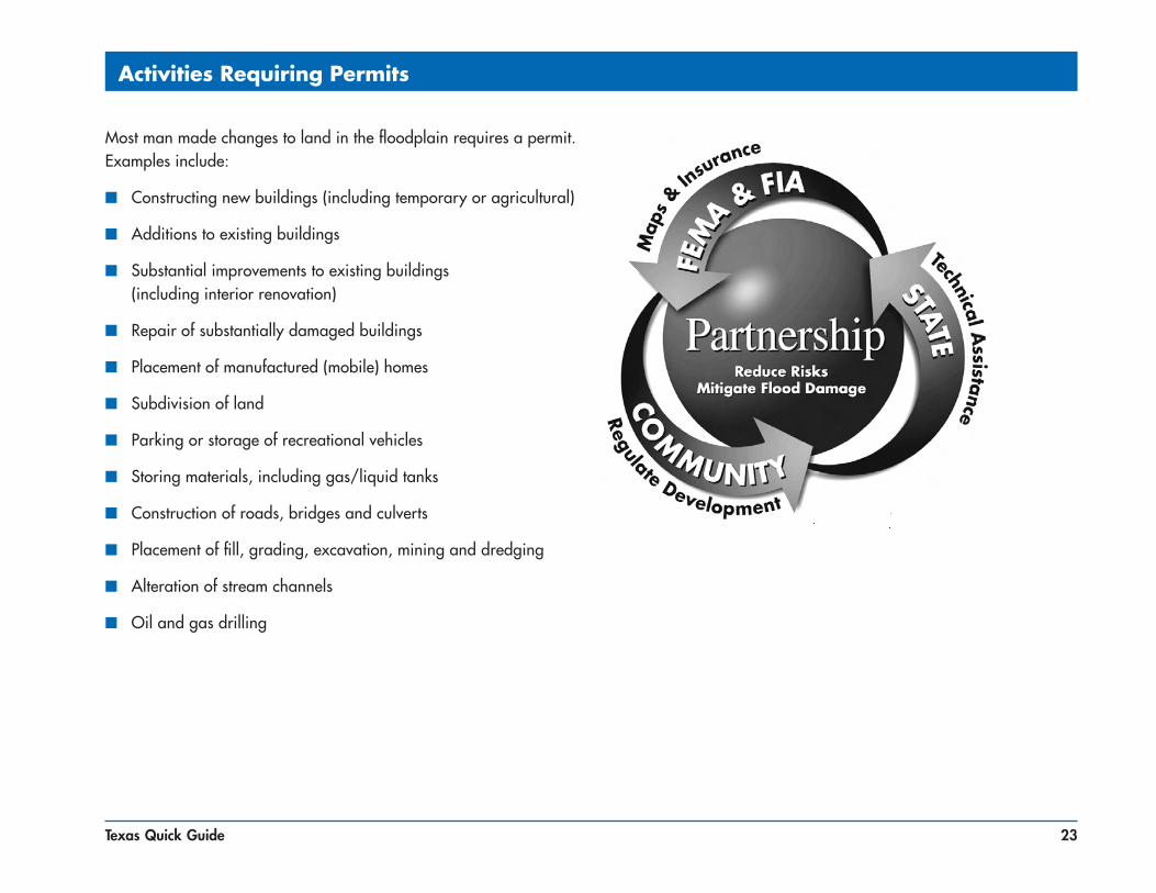
Activities Requiring Permits
Most man made changes to land in the floodplain requires a permit. Examples include:
■ Constructing new buildings (including temporary or agricultural)
■ Additions to existing buildings
■ Substantial improvements to existing buildings (including interior renovation)
■ Repair of substantially damaged buildings
■ Placement of manufactured (mobile) homes
■ Subdivision of land
■ Parking or storage of recreational vehicles
■ Storing materials, including gas/liquid tanks
■ Construction of roads, bridges and culverts
■ Placement of fill, grading, excavation, mining and dredging
■ Alteration of stream channels
■ Oil and gas drilling

24 Texas Quick Guide
Safe Uses of the Floodplain
Let the floodplain do its job – if possible, keep it natural open space. Other low damage uses may include recreational areas, playgrounds, reforestation, parking, gardens, pasture, accessory structures, created wetlands, ecosystem restoration and wildlife management.
All land subdivided into lots, some lots partially in the floodplain, setbacks modified to keep homesites on high ground.
RECOMMENDED
Floodplain land put into public/common open space, net density remains, lot sizes reduced and setbacks modified to keep homesites on high ground.
All land subdivided into lots, some homesites and lots partially or entirely in the floodplain.
NOT RECOMMENDEDRECOMMENDED

25Texas Quick Guide
Is Your Building Site Higher than the BFE?
If your land is shown on the map as “in” the regulatory floodplain, but your building site is higher than the Base Flood Elevation (BFE)… get a licensed land surveyor or engineer to complete a FEMA Elevation Certificate (EC). Submit the EC with an application for a Letter of Map Amendment to FEMA to verify that your property is above the BFE. If approved, it will remove the mandatory federal requirement to purchase flood insurance if you have a federally backed mortgage. Keep the certificate with your deed, it will help future buyers.

26 Texas Quick Guide
What is Meant by Pre-FIRM and Post-FIRM?
A building is Pre-FIRM if it was built before the date of your community’s first FIRM or before December 31, 1974. If built after that date, a building is Post-FIRM.
Improvements or repairs to Pre-FIRM buildings may require permits (see pages 29 and 30).

27Texas Quick Guide
Nature Doesn’t Read Maps
CAUTION: Nature doesn’t read the flood map. Major storms and flash floods can cause flooding that rises higher than the 100-year elevation (BFE). Consider safety – protect your home or business by building higher. See page 31 to see how this will save you money on insurance.
Many people don’t understand just how risky the floodplain can be. There is a 26% chance that a non-elevated home in the floodplain will be damaged during a 30-year mortgage period. The chance that a major fire will occur during the same period is less than 5%.

28 Texas Quick Guide
Think Carefully Before You Seek A Variance
Very specific conditions must be satisfied to justify a variance:
■ Good and sufficient cause
■ Unique site conditions
■ Individual non-economic hardship
■ If in the floodway, no increase in flood level
A variance that allows construction below the BFE does not waive your lender’s flood insurance requirement. Flood insurance will be very expensive – perhaps more than $3,000 per year as compared to less than $500 (see page 31).
Think carefully about seeking a variance to build below the Base Flood Elevation. Not only will your property be more likely to get damaged, but insurance will be very costly.
If your community has a pattern of inconsistent variances, FEMA sanctions can be imposed – costing you even more.
29Texas Quick Guide
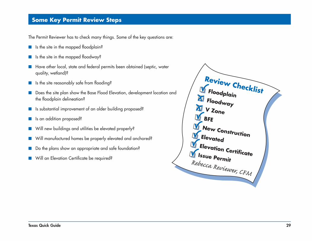
Some Key Permit Review Steps
The Permit Reviewer has to check many things. Some of the key questions are:
■ Is the site in the mapped floodplain?
■ Is the site in the mapped floodway?
■ Have other local, state and federal permits been obtained (septic, water quality, wetland)?
■ Is the site reasonably safe from flooding?
■ Does the site plan show the Base Flood Elevation, development location and the floodplain delineation?
■ Is substantial improvement of an older building proposed?
■ Is an addition proposed?
■ Will new buildings and utilities be elevated properly?
■ Will manufactured homes be properly elevated and anchored?
■ Do the plans show an appropriate and safe foundation?
■ Will an Elevation Certificate be required?

30 Texas Quick Guide
Good information will lead to better construction and less exposure to future flood damage.
You must get a permit before you do work in a floodplain.
Carefully Complete the Permit Application
781 Reed StReet
Rebecca Reviewer, CFM
david & Sally JoneS
X XX
XdRy RiveR
59.260.2
4/2/2007

31Texas Quick Guide
Want to save some money and have peace of mind at the same time? Then add Freeboard to build higher than the minimum elevation requirement. Freeboard is a factor of safety, usually one or two feet above the BFE. Freeboard tends to compensate for the many unknown factors that could contribute to flood heights greater than the BFE.
Annual Flood Insurance CostIf you have: a post-FIRM structure in an AE Zone with $250,000 structural coverage (maximum) with $100,000 contents (maximum)
The approximate annual cost for flood insurance:+3 ft. $500+2 ft. $550+1 ft. $700BFE $1,100-1 ft. $5,000-2 ft. expensive (submit for rate)
Freeboard: Build Above the BFE
NOTE: Flood insurance rates and various fees change from time to time. Rather than specific costs for insurance, this figure gives a feel for how much difference just a foot or two can make.
Building owners will save insurance money if they elevate above the BFE. But more impressive is how the cost of insurance can more than double if the building is only one foot below the BFE.
Remember: The community may be able to grant a variance, but the owner will probably still be required to buy insurance. Imagine trying to sell a house if the bank requires insurance that costs about $5,000 a year.
✔
✔
✔
✔

32 Texas Quick Guide
■ The Elevation Certificate (EC) is a FEMA form used to record building elevation site conditions and FIRM information for a development site. Go to http://www.fema.gov/library/ and search for “Elevation Certificate.”
■ The EC must be completed and sealed by a licensed surveyor or engineer.
■ A community official or property owner may complete the EC for sites in approximate flood zones and AO Zones.
■ It can be used to show that the ground at a development is above the Base Flood Elevation (see page 25).
■ It is used to verify that buildings are elevated properly (see pages 29 and 34).
■ Insurance agents use the EC to write and rate flood insurance policies.
By itself, the EC cannot be used to waive the requirement to get flood insurance. See page 25 to learn about Letters of Map Amendment.
What is the Elevation Certificate and How is it Used?

33Texas Quick Guide
Completing the Elevation Certificate
In this example, the BFE is 285.
The slab-on-grade house was elevated on fill 1' above the BFE, and the vented garage is 2.5' below the BFE.
You will get a blank Elevation Certificate form when you get your permit. You must have a licensed surveyor or engineer fill it out and seal it. The Elevation Certificate includes diagrams for eight building types. Several points must be surveyed.
Elevation Certificate (partial)
SECTION C - BUILDING ELEVATION INFORMATION (SURVEY REQUIRED)
C1. Building elevations are based on: Construction Drawings* Building Under Construction* Finished Construction *A new Elevation Certificate will be required when construction of the building is complete.
C2. Elevations – Zones A1-A30, AE, AH, A (with BFE), VE, V1-V30, V (with BFE), AR, AR/A, AR/AE, AR/A1-A30, AR/AH, AR/AO. Complete Items C2.a-g below according to the building diagram specified in Item A7.
Benchmark Utilized Vertical Datum
Conversion/Comments Check the measurement used.
a) Top of bottom floor (including basement, crawl space, or enclosure floor) . feet meters (Puerto Rico only)
b) Top of the next higher floor . feet meters (Puerto Rico only)
c) Bottom of the lowest horizontal structural member (V Zones only) . feet meters (Puerto Rico only) d) Attached garage (top of slab) . feet meters (Puerto Rico only)
e) Lowest elevation of machinery or equipment servicing the building . feet meters (Puerto Rico only) (Describe type of equipment in Comments) f) Lowest adjacent (finished) grade (LAG) . feet meters (Puerto Rico only)
g) Highest adjacent (finished) grade (HAG) . feet meters (Puerto Rico only)
✔
✔
✔
✔✔
✔
286 00
navd 88none
RM66
286 0282 5
286 0282 5
n/an/a

34 Texas Quick Guide
Paperwork is Important – for You and Your Community
If you get a permit to build in the floodplain, you will be given an Elevation Certificate form. As soon as your lowest floor is set, get the form filled out and sealed by a licensed surveyor or engineer. This form is important. It proves that you built correctly, and it can be used to get the lowest cost flood insurance.
Lowest Floor means the lowest floor of the lowest enclosed area (including basement). An unfinished or flood resistant enclosure (that is not a basement) is not the lowest floor if the enclosure is built as required in the local ordinance (see page 41), and is used for parking, access and limited storage.

35Texas Quick Guide
Floodplain Fill Can Make Things Worse
Floodplains are supposed to store floodwater. If storage space is filled with dirt and other material, future flooding may be worsened. Your community may require an engineering analysis (“no rise” certificate) to show how floodplain fill will alter flooding. Floodplain fill can alter other valuable floodplain functions, including wildlife habitat and wetlands.
Make sure your floodplain fill project won’t harm your neighbors. Floodway fill is allowed only if an engineering evaluation demonstrates that “no-rise” in flood level will occur (see page 36).

36 Texas Quick Guide
Recommended Floodway “No Rise” Certification
■ Floodways can be dangerous because water may flow very fast
■ Development is not allowed unless “no rise” in flood levels, floodway elevations and floodway widths is certified
■ An engineer must evaluate the hydraulic impact of proposed development
■ A “no rise” certification is required and must be signed, sealed, and dated by a registered professional engineer
■ Check with your community for guidance before you decide to work in a floodway
The engineering analysis must be based on technical data approved from FEMA. Save time and money – don’t build in the floodway.
ENGINEERING “NO-RISE” CERTIFICATION (example)
This is to certify that I am a duly qualified engineer licensed to practice in the State of Texas. It is to further certify that the attached technical data supports the fact that proposed (Name of Development) will not impact the Base Flood Elevations (100-year flood), floodway elevations
and the floodway widths on (Name of Stream) in (Name of Community).
Signature Seal

37Texas Quick Guide
How to Elevate Your Floodplain Building (Riverine)
Caution: Enclosures (including crawlspaces) have some special requirements, see page 41. Note: When the walking surface of the lowest floor is at the minimum elevation, under-floor utilities are not allowed. Fill used to elevate buildings must be placed properly (see page 38).
38 Texas Quick Guide
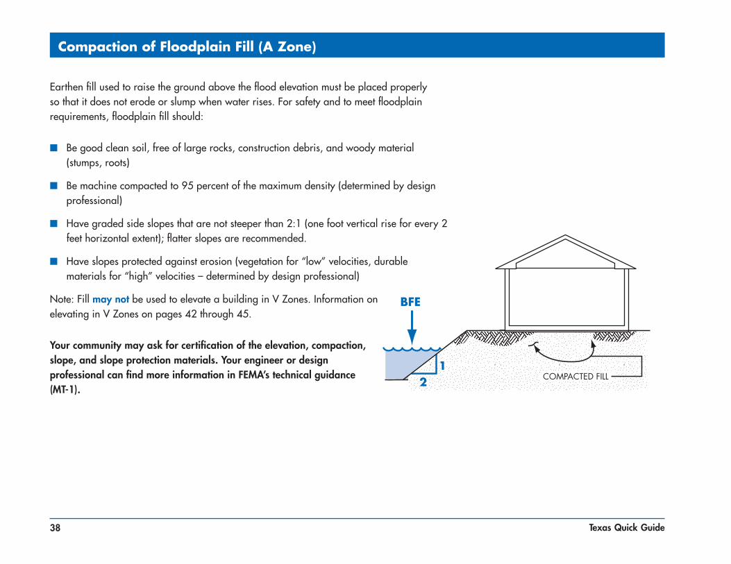
Compaction of Floodplain Fill (A Zone)
Earthen fill used to raise the ground above the flood elevation must be placed properly so that it does not erode or slump when water rises. For safety and to meet floodplain requirements, floodplain fill should:
■ Be good clean soil, free of large rocks, construction debris, and woody material (stumps, roots)
■ Be machine compacted to 95 percent of the maximum density (determined by design professional)
■ Have graded side slopes that are not steeper than 2:1 (one foot vertical rise for every 2 feet horizontal extent); flatter slopes are recommended.
■ Have slopes protected against erosion (vegetation for “low” velocities, durable materials for “high” velocities – determined by design professional)
Note: Fill may not be used to elevate a building in V Zones. Information on elevating in V Zones on pages 42 through 45.
Your community may ask for certification of the elevation, compaction, slope, and slope protection materials. Your engineer or design professional can find more information in FEMA’s technical guidance (MT-1).

39Texas Quick Guide
Basements Are Unsafe
Basements below the BFE are not allowed in new development and flood insurance coverage is very limited in existing basements for a very good reason. It only takes an inch of water over the sill and the entire basement fills up. Excavating a basement into fill doesn’t always make it safe because saturated groundwater can damage the walls.
A basement is any portion of a building that has its floor sub-grade (below ground level) on all sides.

40 Texas Quick Guide
Experience shows that manufactured homes are easily damaged. As little as one foot of water can cause substantial damage.
Dry stacked blocks are NOT acceptable — they will NOT withstand a flood.
Manufactured homes must be anchored to resist flotation, collapse, or lateral movement by being tied down in accordance with your community’s ordinance or the manufacturers’ installation specifications.
Manufactured Homes Deserve Special Attention

41Texas Quick Guide
Enclosures Below the BFE (Riverine Only)
Solid perimeter wall foundations can enclose flood-prone space. A crawlspace is a good way to elevate just a couple of feet. In all cases, the following are required: openings/vents, elevated utilities, flood resistant materials, and limitations on use.
TOTAL NET AREA OF ALL TOTAL OPENINGS IS 1 SQ. IN. PER SQ. FT. OF ENCLOSED AREA
A 25' X 45' BUILDING NEEDS 1125 SQ. INCHES OF OPENINGS (25 X 45 = 1125)
STANDARD VENTILATION UNITS USED IN BLOCK FOUNDATION WALLS MUST BE DISABLED IN THE OPEN POSITION TO ALLOW WATER TO FLOW IN AND OUT
A STANDARD VENTILATION UNIT, WITH SCREEN, PROVIDES 42 TO 65 SQ. INCHES OF OPENING
ENGINEERED OPENINGS ARE ACCEPTABLE IF CERTIFIED TO ALLOW ADEQUATE AUTOMATIC INFLOW AND OUTFLOW OF WATER

42 Texas Quick Guide
Typical Elevation Methods for Coastal Buildings
In V Zones the design specifics will be determined by your licensed architect or engineer based on your site, including how your building will be elevated and how deep in the ground the foundation elements will extend. Your community will require certified or sealed building designs and plans (see page 45).
See details on page 43

43Texas Quick Guide
Coastal Houses Must Resist Wind and Water Forces
Coastal buildings may be exposed to both hurricane winds and floodwater, so they must be built to hold together during storms. These details are only examples. Your architect or engineer will decide the type of clips and straps to keep the roof and building connected to the foundation.

44 Texas Quick Guide
Enclosures Below V Zone Buildings
Avoid building an enclosure under your V Zone building. If you must enclose a small area, your community will require:
■ Walls designed to collapse or “breakaway” under storm and flood conditions
■ Flood resistant materials
■ Utility wires and pipes should not go through or be attached to the breakaway walls
■ Enclosed area is to be used only for parking, building access, or storage
■ No bathrooms, utility rooms, or electric service below BFE
■ Size limited to 300 square feet or less
Do not modify an enclosure below an elevated V Zone building (or any zone for that matter). It is a violation of your community’s regulations, and you may have increased damage when it floods. Plus, your flood insurance policy will cost a lot more.
45Texas Quick Guide
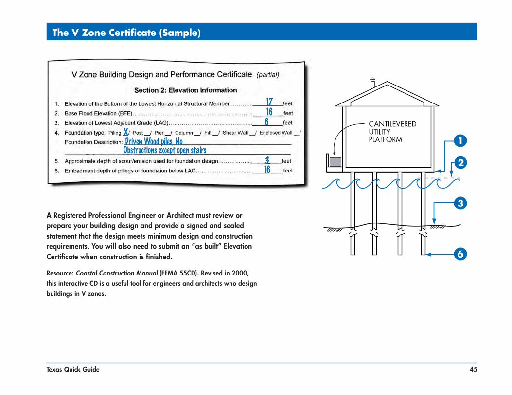
The V Zone Certificate (Sample)
A Registered Professional Engineer or Architect must review or prepare your building design and provide a signed and sealed statement that the design meets minimum design and construction requirements. You will also need to submit an “as built” Elevation Certificate when construction is finished.
Resource: Coastal Construction Manual (FEMA 55CD). Revised in 2000, this interactive CD is a useful tool for engineers and architects who design buildings in V zones.
163
1617
6X driven Wood piles, noobstructions except open stairs
46 Texas Quick Guide
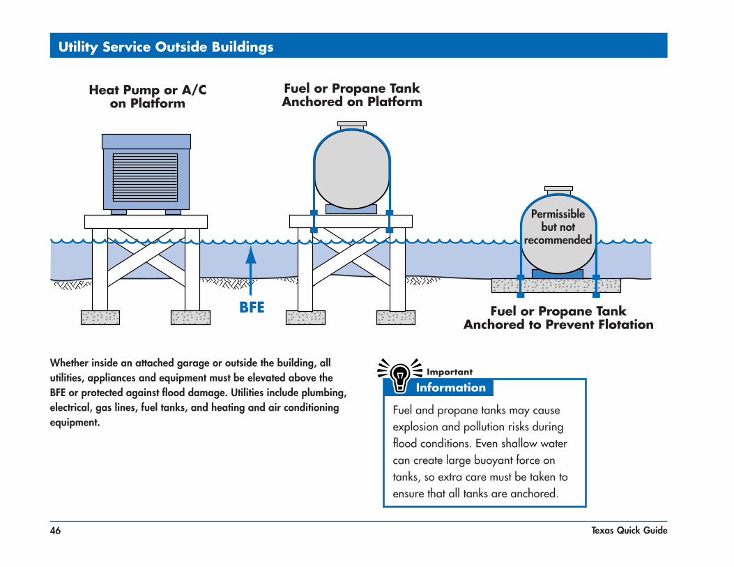
Utility Service Outside Buildings
Whether inside an attached garage or outside the building, all utilities, appliances and equipment must be elevated above the BFE or protected against flood damage. Utilities include plumbing, electrical, gas lines, fuel tanks, and heating and air conditioning equipment.
Fuel and propane tanks may cause explosion and pollution risks during flood conditions. Even shallow water can create large buoyant force on tanks, so extra care must be taken to ensure that all tanks are anchored.
Heat Pump or A/Con Platform
Fuel or Propane TankAnchored to Prevent Flotation
Fuel or Propane TankAnchored on Platform
Permissible but not
recommended

47Texas Quick Guide
Utility Service Inside Enclosures
All utilities, appliances, and equipment must be elevated above
the BFE or protected. Utilities include plumbing, electrical, gas lines, heating, and air
conditioning.
48 Texas Quick Guide
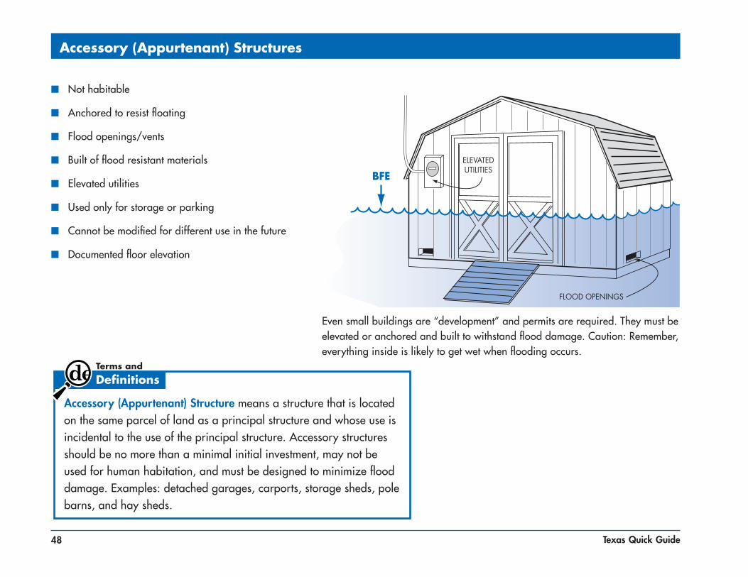
Accessory (Appurtenant) Structures
Even small buildings are “development” and permits are required. They must be elevated or anchored and built to withstand flood damage. Caution: Remember, everything inside is likely to get wet when flooding occurs.
■ Not habitable
■ Anchored to resist floating
■ Flood openings/vents
■ Built of flood resistant materials
■ Elevated utilities
■ Used only for storage or parking
■ Cannot be modified for different use in the future
■ Documented floor elevation
Accessory (Appurtenant) Structure means a structure that is located on the same parcel of land as a principal structure and whose use is incidental to the use of the principal structure. Accessory structures should be no more than a minimal initial investment, may not be used for human habitation, and must be designed to minimize flood damage. Examples: detached garages, carports, storage sheds, pole barns, and hay sheds.

49Texas Quick Guide
Recreational Vehicles
In a flood hazard area, an RV must:
■ Be licensed and titled as an RV or park model (not as a permanent residence)
■ Be built on a single chassis
■ Have inflated tires and be self-propelled or towable by light truck
■ Have no attached deck, porch, shed
■ Be used for temporary recreational, camping, travel, or seasonal use (no more than 180 days)
■ Be less than 400 sq. ft. in area (measured at largest horizontal projection)
■ Have quick-disconnect sewage, water, and electrical connectors
RVs that do not meet these conditions must be installed and elevated like Manufactured Homes, including permanent foundations and tie-downs (see page 40).
Camping near the water? Ask the campground or RV park operator about flood warnings and plans for safe evacuations.
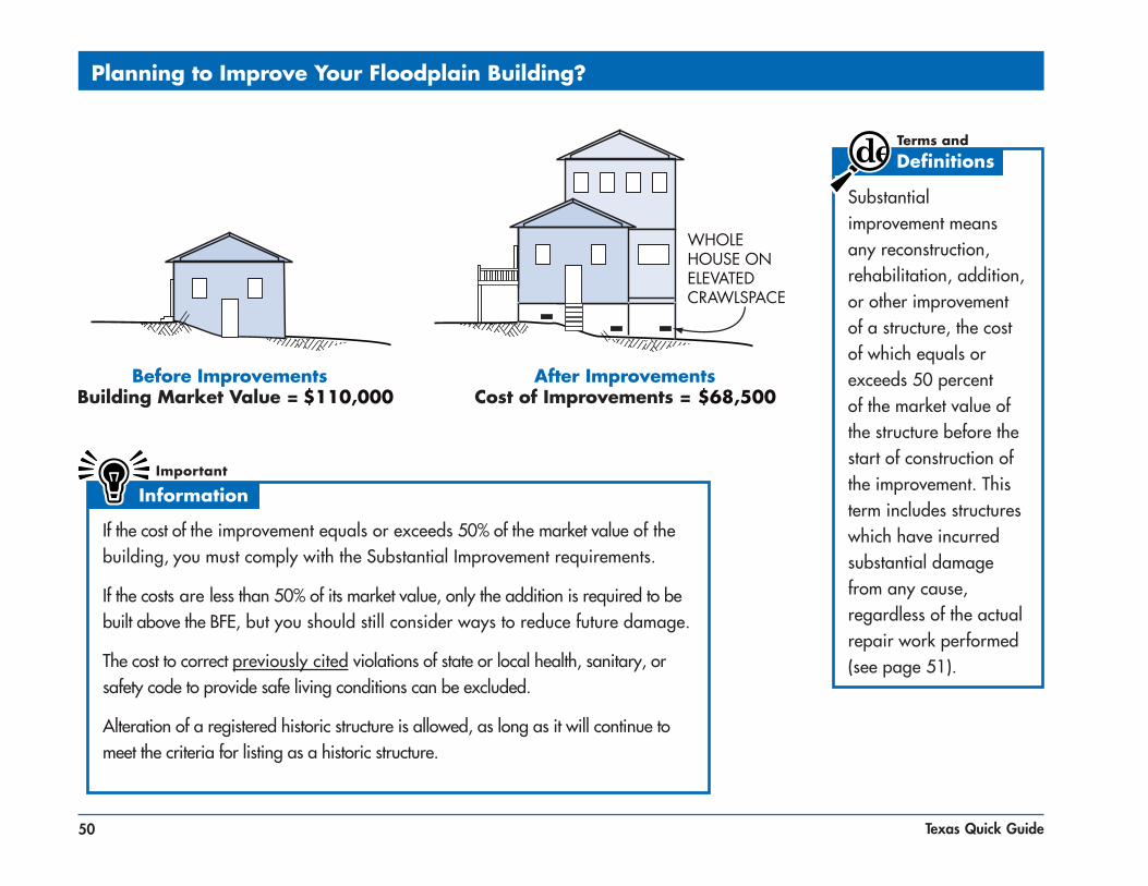
50 Texas Quick Guide
Planning to Improve Your Floodplain Building?
Substantial improvement means any reconstruction, rehabilitation, addition, or other improvement of a structure, the cost of which equals or exceeds 50 percent of the market value of the structure before the start of construction of the improvement. This term includes structures which have incurred substantial damage from any cause, regardless of the actual repair work performed (see page 51).
If the cost of the improvement equals or exceeds 50% of the market value of the building, you must comply with the Substantial Improvement requirements.
If the costs are less than 50% of its market value, only the addition is required to be built above the BFE, but you should still consider ways to reduce future damage.
The cost to correct previously cited violations of state or local health, sanitary, or safety code to provide safe living conditions can be excluded.
Alteration of a registered historic structure is allowed, as long as it will continue to meet the criteria for listing as a historic structure.

51Texas Quick Guide
What About After Damages?
$60,500
A permit is required to repair substantial damage from any cause — fire, flood, wind, or even a truck running into a building. Check with your community permit office to be sure. You will be asked to provide a detailed cost estimate for repairs. See page 52 for more information about elevating an existing building on a crawlspace.

52 Texas Quick Guide
Elevating a Pre-FIRM Building
This is one way to elevate an existing building to comply with floodplain regulations. If your insured building is damaged by flood, you may be eligible for an Increased Cost of Construction payment. The state and FEMA can help with more information and options.

53Texas Quick Guide
Some Flood Protection for Older Homes is Easy and Low Cost
Move your hot water heater, furnace and ductwork out of basements and crawlspaces or build small platforms for them above the BFE. Anchor heating oil and propane tanks to prevent flotation. Do not store valuables or hazardous material in a flood-prone basement or crawlspace. Use water-resistant materials when you repair.

54 Texas Quick Guide
Small Levees and Floodwalls Can Protect Some Older Homes
In areas where floodwaters aren’t expected to be deep, sometimes individual buildings can be protected by earthen levees or concrete floodwalls. You must get a permit for those protection measures, and extra care must be taken if the site is in a floodway. A levee or floodwall cannot be used to comply with floodplain regulations for a new or substantially improved building, or one that is repaired after substantial damage. Important: These protective measures will not reduce your flood insurance premium.

55Texas Quick Guide
Some Flood Mitigation Projects are More Costly ut Give You More Protection
After floods, some communities buy out and demolish homes that were severely damaged. The acquired land is dedicated to open space and can be used for recreation or to help restore wildlife habitat and wetlands. In other instances, homes have been raised up on higher foundations, and others have been moved to safer high ground.
56 Texas Quick Guide
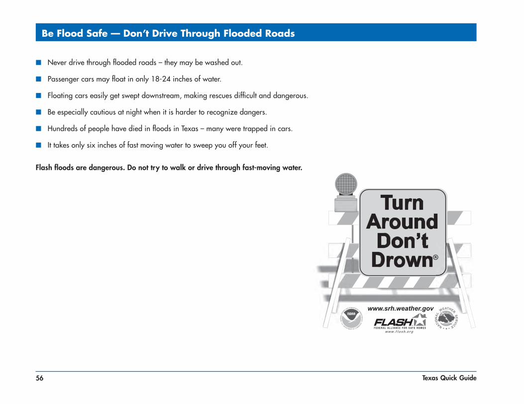
Be Flood Safe — Don’t Drive Through Flooded Roads
■ Never drive through flooded roads – they may be washed out.
■ Passenger cars may float in only 18-24 inches of water.
■ Floating cars easily get swept downstream, making rescues difficult and dangerous.
■ Be especially cautious at night when it is harder to recognize dangers.
■ Hundreds of people have died in floods in Texas – many were trapped in cars.
■ It takes only six inches of fast moving water to sweep you off your feet.
Flash floods are dangerous. Do not try to walk or drive through fast-moving water.

57Texas Quick Guide
Useful Web Sites and Common Acronyms
Useful Web Sites
■ American Red Cross: http://www.redcross.org/services/disaster
■ FEMA Resource Library: http://www.fema.gov/library/
■ FEMA NFIP information: http://www.fema.gov
■ FEMA Map Service Center: http://msc.fema.gov
■ Community Rating System (CRS) Resource Center: http://www.training.fema.gov/EMIweb/CRS
■ Association of State Floodplain Managers: http://www.floods.org
■ Texas Floodplain Management Association: http://www.tfma.org
■ Texas Water Development Board: http://twdb.state.tx.us
■ Texas Department of Insurance: http://tdi.state.tx.us
■ Texas General Land Office: http://www.glo.state.tx.us
■ Texas Division of Emergency Management: http://dps.state.tx.us/dem
■ Texas Hazard Mitigation Package: http://www.thmp.info/
Common Acronyms
■ BFE = Base Flood Elevation
■ EC = Elevation Certificate
■ FEMA = Federal Emergency Management Agency
■ FIRM = Flood Insurance Rate Map
■ NFIP = National Flood Insurance Program
■ SFHA = Special Flood Hazard Area
■ TWDB = Texas Water Development Board
■ TFMA = Texas Floodplain Management Association

58 Texas Quick Guide
Resources
Federal Agency Resources
Federal Emergency Management Agency (FEMA)Is the originating Agency for NFIP & Map Modernization Program. Provides for studies to update Flood Insurance Rate Maps. Prepares updated digitized FIRMs and publishes “Preliminary” D-FIRMs.www.fema.gov for general informationwww.msc.fema.gov for the Map Service Center
U.S. Army Corps of EngineersConducts flood studies. Oversees capital projects in waterways. Determines flood damage assessments for property buyouts. Issues 404 Wetlands Permits.www.usace.army.mil
National Weather ServiceProvides weather forecasts and severe weather alerts through the internet, television, and NOAA All Hazard Radio. Regional River Forecast Office provides flood forecasts. Promotes Severe Weather and Turn Around Don’t Drown awareness.www.weather.gov
U.S. Fish and WildlifeMay be required to involve in certain projects to issue a permit.www.fws.gov
National Park ServiceMay be required to involve in certain projects to issue a permit.www.nps.gov
Association of State Floodplain Managers (ASFPM)Provides technical information for Nation Wide floodplain management challenges, legislation, and support.www.floods.org

59Texas Quick Guide
Resources
Environmental Protection Agency (EPA)Provides guidance on Clean Water Act and may need to be contacted for certain permits to be issued.www.epa.gov
National Resource Conservation Service (NRCS)May be required to involve in certain projects to issue a permit and may have technical information relevant to floodplain management.www.nrcs.usda.gov
National Highway AdministrationMay be required to involve in certain projects to issue a permit.www.nhtsa.dot.gov
State Agency Resources
Texas Water Development Board (TWDB) State National Flood Insurance Program (NFIP) Coordinating Agency. Partners with FEMA – Community Assistance Program. Provides technical assistance, training, ordinance/court order assistance, and public outreach. Part of the Agency entails the Texas Natural Resources Information System (TNRIS) which is the State mapping and geographic information data repository. State Map Modernization Coordinator. Manages Flood Mitigation Assistance Grant Program, Flood Protection Planning Grant fund, and the Severe Repetitive Loss Grant fund.
Mike Howard is the NFIP State Coordinator; his phone number is (512) 463-3509. The Board also has 6 Regional Offices that are staffed with NFIP knowledgeable staff: Austin (512) 463-4350 El Paso (915) 834-5626 Harlingen (956) 421-3214 Houston (281) 895-6555 Mesquite (972) 285-8078 San Antonio (210) 212-9324
www.twdb.state.tx.uswww.twdb.state.tx.us/planning/flood/fmp.asp#nfip for community floodplain administrators and community status list.

60 Texas Quick Guide
Resources
Governor’s Division of Emergency ManagementState Coordinator for Emergency Management in Texas. Provides for State and Federal disaster preparedness, response, recovery, and mitigation. Is the State Hazard Mitigation Officer (SHMO). Administers the Federal Hazard Mitigation Grant Program (HMGP) and Pre-Disaster Mitigation (PDM) grant program.www.txdps.state.tx.us/dem
Texas Department of InsuranceNamed as co-coordinator for the NFIP in Texas (TWDB is the other State agency). Provides aid, advises and cooperates with all participating political subdivisions. Administers Windstorm Inspection Program (first tier of Texas counties fronting Gulf of Mexico). Facilitates availability of wind insurance.www.tdi.state.tx.us
Texas Commission on Environmental Quality (TCEQ)Oversees State Dam Safety Program, which monitors and regulated both private and public dams in Texaswww.tceq.state.tx.us
Texas Office of Rural Community AffairsManages community development grants including the Community Development Block Grant and the Disaster Relief & Urgent Need fund for communities after a disasterwww.orca.state.tx.us
Texas General Land Office (GLO)Texas Coastal Management Program (CMP) is to improve the management of the State’s coastal natural resources and to ensure the long-term ecological and economic productivity of the coast. Oversees Open Beaches Act, which provides that all beaches be public land and open for public access. Manages Dune Protection Program, which protects sand dunes for coastal stabilization, storm protection, ecosystem management, and economic development.www.glo.state.tx.us

61Texas Quick Guide
Resources
Texas Department of Housing and Community Affairs (TDHCA)Have anchoring regulations listed for manufactured homes and other important information regarding installation of manufactured homes.www.tdhca.state.tx.us
Texas Department of HealthHandles individual grants for families after a disaster.www.dshs.state.tx.us
Texas Parks and WildlifeHandles permits for sand and gravel operations and addresses environmental concerns.www.tpwd.state.tx.us
National Legislation/Regulation
National Flood Insurance Act of 1968 Established National Flood Insurance Program; a voluntary program based on mutual agreement between Federal government and local community. In exchange for adopting and enforcing a Floodplain Management Ordinance or Court Order, federally backed flood insurance is made available to property owners throughout the participating community. Prior to the 1968 Act the sole relief available to flood victims was special disaster loans. See 44 Code of Federal Regulations (CFR) Chapter 60.3 (a-e) for detailed floodplain management regulations.
Flood Disaster Protection Act of 1973Now required flood insurance as a condition for Receiving federal financial assistance for acquisition or construction purposes in Special Flood Hazard areas. Publication of Flood Hazard Boundary Maps now officially designated a community as “flood prone” and subject to the act.

62 Texas Quick Guide
Resources
Executive Order 11988Specified responsibility for Federal government to adhere to the NFIP regulations like local communities. Federal Agencies are now required to “avoid long-and short-term adverse impacts associated with the occupancy and modification of floodplains and avoid direct and indirect support of floodplain development wherever there is a practicable alternative”. Federally funded “Critical Facilities” like Hospital and Fire Stations are to be protected to the 0.2% Annual Chance Event or 500 year flood.
Section 404 Wetlands PermitsThe US Army Corps of Engineers administers Section 404 of the Clean Water Act. Discharge of dredge or fill material into wetlands requires a Section 404 permit. Communities are required under the NFIP to require completion of all necessary permits required by Federal and State Law prior to issuing floodplain development permit.
Disaster Mitigation Act of 2000Communities must adopt and have an approved all hazards mitigation plan prior to November 1, 2004 to be eligible to receive Hazard Mitigation Grant Program funding (44 CFR Part 201).
State Legislation/Regulation
House Bill 1018Requires cities and counties to join the NFIP. The 77th Legislature of the State of Texas amended Subchapter 1, Chapter 16 in the Water Code by adding Section 16.3145 to read as follows: “The governing body of each city and county shall adopt ordinances or orders, as appropriate, necessary for the city or county to be eligible to participate in the National Flood Insurance Program, not later than January 1, 2001”. Was prompted after three Presidential Disaster declarations.

63Texas Quick Guide
Resources
Senate Bill 93677th legislative session; Allowed counties and general law cities to regulate on the same level as cities are able to. Adoption of more comprehensive floodplain management regulations are now possible, thanks to this bill. The bill also allows counties to collect reasonable fees to cover administrative costs incurred by the administration of a local floodplain management program. It also provides for Criminal and Civil Penalties and injunctive relief.
House Bill 144577th legislature session; Provides regulation of subdivisions in Extraterritorial Jurisdictions (ETJ). It authorizes the municipality and the count to enter into an inter-local agreement to establish floodplain development regulations for plats and subdivisions within the ETJ.
House Bill 148179th legislative session; Barricade law that makes is a criminal offense to cross a barricade at a flooded area.
Flood Control and Insurance ActCreated in 1969. Stated the need to participate in the 1968 National Flood Insurance Program: “The purpose of this Act is to evidence a positive interest in securing flood insurance coverage under this Federal program, and to so procure for those citizens of Texas desiring to participate; and the promoting of public interest by providing appropriate protection against the perils of flood losses and encouraging sound land use by minimizing exposure of property to flood losses.”
Senate Bill 1601 75th legislature; Relating to utility hookup only being approved once all necessary permits have been completed with the jurisdiction.


![DCA1000EVM Quick Start Guide - Texas Instruments · 2019. 5. 15. · Title: DCA1000EVM Quick Start Guide Author: Texas Instruments, Incorporated [SPRUIK7,*] Subject: Quick Start Keywords:](https://static.fdocuments.in/doc/165x107/60e0140ed6ecac5f64690298/dca1000evm-quick-start-guide-texas-instruments-2019-5-15-title-dca1000evm.jpg)