2008 Annual Report - Wyoming Game and Fish Department
88
2008 ANNUAL REPORT Strategic Habitat Plan Accomplishments Aquatic Habitat, Terrestrial Habitat, Habitat and Access Maintenance, Lands Administration Sections WYOMING GAME & FISH DEPARTMENT APRIL 2009
Transcript of 2008 Annual Report - Wyoming Game and Fish Department

2008 ANNUAL REPORTStrategic Habitat Plan
Accomplishments
Aquatic Habitat, Terrestrial Habitat, Habitat and Access Maintenance, Lands Administration Sections
WYOMING GAME & FISH DEPARTMENT
APRIL 2009

2008 ANNUAL REPORT
Strategic Habitat PlanAccomplishments
Aquatic Habitat, Terrestrial Habitat, Habitat and Access Maintenance, and Lands Admin-istration Sections
Wyoming Game and Fish Department
Mission Restore and/or manage habitat to enhance and sustain wildlife populations in the future.
Vision
The WGFD is the steward of Wyoming’s wildlife, dedicated to the conservation of sustainable, functional ecosystems capable of supporting wildlife populations at least as healthy, abundant and
diverse as they were at the dawn of the 21st century. We will take a holistic approach to habitat management, integrating various land uses while involving the general public, private landowners
and land management agencies. Our lands will be managed to emphasize and maintain the wildlife habitat and public access values for which they were obtained.

i
TABLE OF CONTENTS
Table of Contents........................................................................................................................................... i
Regional Personnel........................................................................................................................................ ii
Introduction.................................................................................................................................................... 1
Lands Administration.....................................................................................................................................5
Casper Region................................................................................................................................................ 8
Cody Region.................................................................................................................................................. 18
Green River Region....................................................................................................................................... 30
Jackson Region.............................................................................................................................................. 37
Lander Region................................................................................................................................................ 48
Laramie Region.............................................................................................................................................. 54
Pinedale Region............................................................................................................................................. 61
Sheridan Region.............................................................................................................................................73

ii
REGIONAL PERSONNEL
AdministrationAquatic Habitat Paul Dey, Aquatic Habitat Program Manager, Cheyenne (307) 777-4559 Dennis Oberlie, Aquatic Habitat Biologist Supervisor, Lander (307) 332-7723 Ext. 235 Tom Annear, Water Management Supervisor, Cheyenne (307) 777-4559
Mike Robertson, Instream Flow Biologist (307) 777-4559Habitat and Access Maintenance Bill Cowling, Branch Chief, Lander (307) 332-2688 Scot Kofron, Assistant Branch Chief, Casper (307) 473-3430Lands Administration Dave Hunt, Supervisor, Cheyenne (307) 777-4596 Allen Bott, Lands Resource Biologist, Cheyenne (retired) Kerry Olson, Lands Resource Biologist, Cheyenne (307) 777-4563Terrestrial Habitat Gary Butler, Terrestrial Habitat Program Manager, Cheyenne (307) 777-4565 Bill Gerhart, Assistant Terrestrial Habitat Program Manager, Cheyenne (307) 777-4576 KaAnn Tray, Terrestrial Habitat Admin. Secretary, Cheyenne (307) 777-4590
Casper Region-3030 Energy Lane, Casper, WY 82601Aquatic Habitat Geoffrey Klein, Aquatic Habitat Biologist (resigned) (307) 473-3414Habitat and Access Maintenance Matt Pollock, Supervisor (307) 473-3426
Nick Kafcas, Crew Leader (307) 233-6403 Todd Filipi, Technician (307) 532-2387Terrestrial Habitat Keith Schoup, Terrestrial Habitat Biologist (307) 473-3424 Brian Jensen, Terrestrial Habitat Extension Biologist (307) 261-5436 Ext. 108
Cody Region-2820 St. Hwy. 120, Cody, WY 82414Aquatic Habitat Lewis Stahl, Aquatic Habitat Biologist (307) 527-7322 Ext. *829Habitat and Access Maintenance Steve Ronne, Supervisor (307) 527-7322 Ext. *818
Craig Swanson, Crew Leader (307) 527-7322 Ext. *834 Eric Shorma, Technician (307) 527-7125 Ext. *834Terrestrial Habitat Jerry Altermatt, Terrestrial Habitat Biologist (307) 527-7322 Ext. 13 Amy Anderson, Habitat Extension Biologist, Worland (307) 347-2456 Ext. 108
Green River Region -351 Astle, Green River, WY 82935Aquatic Habitat Kevin Spence, Aquatic Habitat Biologist (307) 875-3225 Ext. 253Terrestrial Habitat Ron Lockwood, Terrestrial Habitat Biologist, Kemmerer (307) 877-3732

iii
Jackson Region-Box 67, Jackson, WY 83001Aquatic Habitat Lara Sweeney, Aquatic Habitat Biologist (307) 733-2383 Ext. 235Habitat and Access Maintenance
Matt Miller, Crew Leader (307) 733-2383 Ext. 239 Terrestrial Habitat Steve Kilpatrick, Terrestrial Habitat Biologist (307) 733-2383 Ext. 227
Lander Region- 260 Buena Vista, Lander, WY 82520Aquatic Habitat Nick Scribner, Aquatic Habitat Biologist (307) 332-7723Habitat and Access Maintenance Brian Parker, Supervisor (307) 332-7723 Ext. 231 Silas Deselms, Crew Leader (307) 332-7723 Ext. 245 Skye Shaw, Technician (307) 455-2421 Statewide Habitat Access and Maintenance Crew Amy Adams, Development Supervisor (307) 332-7723 Ext. 270 Rick Harmelink, Crew Leader (307) 332-7723 Ext. 251 Jeremy Mayhew, Crew Leader (307) 322-7723 Ext. 245 Derek Lemon, Technician (307) 332-7723 Ext. 275 Seth Roseberry, Technician (307) 322-7723 Ext. 260 Terrestrial Habitat Carrie Dobey, Terrestrial Habitat Biologist (307) 332-7723 Ext. 223
Laramie Region-528 S. Adams, Laramie, WY 82070Aquatic Habitat Christina Barrineau, Aquatic Habitat Biologist (307) 745-5180 Ext. 240Habitat and Access Maintenance Dave Lewis, Supervisor (307) 745-5180 Ext. 248 Josh DeBerard, Crew Leader (307) 745-5180 Ext. 246 Steve Page, Technician (307) 745-4046 Ext. 248 Terrestrial Habitat Rick Straw, Terrestrial Habitat Biologist (retired) Grant Frost, Terrestrial Habitat Biologist (307) 745-5180, Ext. 230 Ryan Amundson, Habitat Extension Biologist, Wheatland (307) 322-2605
Pinedale Region-117 S. Sublette Ave., Pinedale, WY 82941Aquatic Habitat Floyd Roadifer, Aquatic Habitat Biologist (307) 367-4347 Ext. 243Habitat and Access Maintenance Ray Bredehoft, Supervisor (307) 367-4347 Ext. 225
Open, Technician (307) 367-4352Terrestrial Habitat Jill Miller, Terrestrial Habitat Biologist (307) 367-4347 Ext. 242
Sheridan Region-700 Valley View, P.O. Box 6249, Sheridan, WY 82801Aquatic Habitat Travis Cundy, Aquatic Habitat Biologist (307) 672-8003 Ext. 230Habitat and Access Maintenance Dave Dearcorn, Supervisor (307) 672-8003 Ext. 240 Terrestrial Habitat Bert Jellison, Terrestrial Habitat Biologist (307) 672-8003 Ext. 229 Erika Peckham, Habitat Extension Biologist, Gillette (307) 682-8843 Ext. 112

1
INTRODUCTION
One of the great challenges facing the Wyoming Game and Fish Department (WGFD) in the 21st century will be our ability to maintain sustainable fi sh and wildlife populations and meet the expectations and desire of
our citizens. Potential impacts to fi sh and wildlife continue to expand, with some of the more noticeable being energy development, increasing demands for water, other land uses, and urban sprawl. The long-term drought, fi re suppression and differences in public expectations and uses of natural resources have caused habitat impacts as well. We must conserve and enhance habitats for all species, while, at the same time conserving habitats essential for species identifi ed at risk in the State Wildlife Action Plan.
To answer these challenges, the Department is actively pursuing habitat-related management activities on a land-scape level partnering with public land managers and private landowners on lands throughout Wyoming. In recognition of this challenge and to help focus efforts and direct funds for habitat-related activities, the Wyoming Game and Fish Commission (WGFC) adopted a Strategic Habitat Plan (SHP) in 2001. An updated and revised SHP was developed during 2008 and adopted by the WGFC in early 2009. This will guide our efforts and direct funds over the next several years. The SHP and priorities habitat areas identifi ed can be viewed on the WGFD website at http://gf.state.wy.us/habitat/StrategicPlan/index.asp.
The purpose of this annual report is to highlight 2008 activities and SHP accomplishments of the Terrestrial Habitat, Aquatic Habitat, and the Habitat and Access Maintenance programs of the WGFD as well as associated portions of the Lands Administration and Water Management Section programs. In addition, many other Department personnel provided invaluable assistance on various aspects of SHP.
Program performance in terms of expenditures on projects is summarized on a statewide basis in the following sections.
I. Approximate WGFD funds (fi gures rounded to the nearest $1,000) expended for on-the-ground projects for im-plementation of SHP goals which include: Goal 1) Manage, preserve and restore habitat for long-term sustainable management of wildlife populations; Goal 2) Increase wildlife based recreation through habitat enhancements that increase productivity of wildlife and; Goal 3) Increase or maintain wildlife habitat and associated recreation on WGFC owned and managed lands during calendar year 2008. These fi gures do not include personnel salaries and equipment used for routine maintenance and operation functions follows:
Department Funds Expended for Goals 1, 2 and 3: $2,679,000
II. Non-Department funds expended for implementation of SHP Goals 1 and 2 for calendar year 2008 from or in collaboration with various sources including but not limited to: a) Farm Bill government funds; b) Other fed-eral government funding programs; c) Other state and local government funding sources; d) Nongovernmental organizations; e) Wyoming Wildlife Heritage Foundation; f) Wyoming Governors Big Game License Coalition; g) Wyoming Wildlife and Natural Resources Trust Fund; f) Private landowners contribution (including in-kind); h) Corporations and businesses; and I) Private donors follows:
Non-Department Funds Expended for Goals 1 and 2: $8,355,000
III. Non-Department funds expended for implementation of SHP Goal 3 for calendar year 2008 from or in col-laboration with various sources cited above follows:
Non-Department Subtotal for Goals 3: $4,000

2
IV. SUBTOTAL NON-DEPARTMENT FUNDS: $ 8,359,000
V. GRAND TOTAL FOR GOALS 1, 2, and 3: $ 11,038,000These fi gures do not include personnel salaries and equipment used for routine maintenance and operationfunctions.
In other words, the Department was able to secure funding from outside sources amounting to approximately$3.12 for each Department dollar expended for on-the-ground fi sh and wildlife habitat activities. This outside funding is a critical element for implementing the Strategic Habitat Plan and conserving our wildlife resources in collaboration with the many dedicated partners throughout the State.
Overall, personnel directly involved in implementing the SHP including routine maintenance and operation activities, oversaw spending of approximately $7,013,000 of WGFD regular maintenance and operating funds, State Wildlife Grants from US Fish and Wildlife Service and Department Trust Fund monies. This fi gure in-cludes wages, benefi ts, equipment operation expenses, supplies and on-the-ground improvement material expenses allocated as follows: approximately 58% for personnel that includes habitat inventories, monitoring, project contact oversight, project design and implementation. Without personnel none of these habitat projects would happen. The remainder of the funding was allocated as follows: 4% for vehicles and heavy equipment and 38% for materials and supplies.
These activities resulted in on-the-ground accomplishments during calendar year 2008 as summarized below:
Strategic Habitat Plan Goals 1 and 2:
On-the-Ground Activity On-the-Ground Accomplishment
Extension Services to private landowner contacts and number of contacts resulting in wildlife habitat enhancement
293 extension contacts resulting in 152 projects
Stream fishery inventories and assessments 68.0 miles Stream bank enhancement 1.0 milesStream structures (revetments, barbs, diversions, screens, sills, jetties, etc.)
35 installed
Water for fisheries and aquatic habitat 100 acre feet for 1 year obtainedPrescribed burns (uplands and CRP enhancement) mainly in aspen, conifer, wooded draw, mixed mountain shrub and sagebrush grassland communities
20,152 acres
Bureau of Land Management Resource Management Plans and US Forest Service Plans
4 Plans
Conservation easements 4 acquired totaling 10,300 acres; 4 being actively pursued
Major Information and Education efforts (formal presentations, articles, booths, radio, television and hosting workshops)
45 formal programs
Herbicide vegetation treatments to control noxious or invasive weeds primarily cheatgrass, prickly pear, Russian olive and salt cedar
7,711.4 acres
Herbicide vegetation to thin dense sagebrush communities 6,067 acresMowing, chopping, and Lawson aerator treatments mainly in sagebrush and grassland communities
350 acres

3
Strategic Habitat Plan Goal 3 – WGFC Managed LandsOn-the-Ground Activity On-the-Ground
AccomplishmentOverseeing maintenance and land management on WGFC Wildlife Management Areas and Public Access Areas
411, 650 acres of WGFC lands 36 Wildlife Management Areas 96 Public Access Areas
Land Acquisition 2 parcels totaling 958 acresIntensive livestock/forage reserve/meadow rejuvenation grazing administered
173,446 acres (Red Canyon and Wick Meadows, Red Rim, Grizzly, Chain Lakes, Renner, Yellowtail, Ocean Lake and Sunshine)
Mowing, chopping, and Lawson aerator treatments mainly in sagebrush and grassland communities
129 acres
Mechanical tree removal mainly conifer removal from aspen stands, juniper and Russian olive and salt cedar removal
700 acres
Grass, forb and food plot seeding 55.5 acresHerbicide vegetation treatments to control noxious or invasive weeds; primarily Russian olive and salt cedar
1,200 acres
Center pivot irrigation sprinkler systems 2 new ones installedIntensive irrigation enhancements 95 acres; 1,200 feet pipe;
5 headgatesFood plot and permanent cover irrigation 235 acresHerbicide application for noxious weed control 2,765 acresFence removal 1.9 milesWater wells drilled 1Reservoir overflow installation 1Beaver transplants 5 beaver
Mechanical tree removal mainly conifer removal from aspen stands, juniper and Russian olive and salt cedar removal
9,278 acres
Tree and shrub planting 12,309 plantedUpland grass, forb and food plot seeding 3,610 acresWater guzzlers installed 10Water wells drilled 1Spring developments 1Water tanks installed 7Water pipelines installed 38,960 feet or about 7.4 milesFences installed to manage or protect treatment areas or to facilitate livestock grazing management
112,654 feet or about 21.3 miles
Wetland development or major renovation 20 acresRiparian habitat protection, enhancement and management 317.8 acresFarm Bill Program contract involvement for 2008 CCRP–14; EQIP-34; GLI-8;
WRP-5; AMA-24; WHIP-4; CRP-14; FFRP-2; CSP-5; and AFO-2
Livestock grazing management plans 255,085 acresUpland habitat inventory (landscape analysis scale) 2.1 million acresUpland habitat inventory (intensive project level scale) 643,801 acresHabitat monitoring sites (annual monitoring) 181 sites monitoredField research projects 9 projectsBeaver transplants 10 beaver

4
We believe habitat is the key to maintaining wild and healthy populations of aquatic and terrestrial wildlife. With-out the support and partnerships of private landowners, public land managers, conservation groups and the public these habitat enhancement projects would not be possible. We greatly appreciate your assistance and support and look forward to working with you to ‘Conserve Wildlife and Serve People’ in the years ahead.
For additional information please contact any of the personnel listed above. Also, feel free to share this report with anyone who may be interested in the Department and Commission’s habitat efforts.
The report can also be viewed on the WGFD website at http://gf.state.wy.us/habitat/AnnualRpts/index.asp.

5
LANDS ADMINISTRATION BRANCH
The Lands Administration Branch is committed to addressing the Department’s property rights objectives for improved habitat conservation, increased hunting and
fi shing access, and monitoring of current property rights. Branch personnel continued to work on a variety of habitat related property rights projects around the state guided by goals and objectives of Department regulations, Commission policy, the Strategic Habitat Plan, and other administrative directives. Signifi cant gains in habitat conserva-tion through acquisition of several conservation easements were among the Branch’s accomplishments.
Conservation EasementsWith the assistance of a supportive Commission and Administration, the
Department has developed an active conservation easement program that rivals any in the state. Progressive landowners continue to contact the Department to discuss conser-vation easement possibilities. Awareness of the program, and understanding of property rights issues, including conservation easement purposes by local Department personnel have greatly aided the Branch. Relationships fostered with landowners by Aquatic and Terrestrial Habitat Biologists, Wildlife Biologists, Game Wardens, and Habitat and Access Specialists have greatly enhanced easement opportunities and have assisted negotiations in many instances.
Conservation Easement FundingLandowners throughout the state have become more interested in conservation
easements during the last several years. Genuine desire to retain family run agricultural enterprises and favorable income tax laws are reasons most landowners consider conservation easements. Landowners must decide if federal income tax benefi ts associated with easement donation best fulfi ll their easement objectives, or if the easement needs to be sold. Many landowners fi nd it necessary to sell conservation easements to organizations like the Department, or other entities like the Upper Green River Valley Land Trust, The Nature Conservancy (TNC), the Rocky Mountain Elk Foundation (RMEF), the Wild Turkey Federation (WTF), the Jackson Hole Land Trust (JHLT), Wyoming Stock Growers Agricultural Land Trust and others. Most landowners and easement holding organizations agree on discounted, or bargain sale, purchases of conservation easements where landowners donate a portion of the value of the easement.
While opportunities for purchased conservation easements are increasing throughout the state, funding remains extremely limited. Department and Commission funds generally provide start-up money for easements, but due to high easement costs, these funds are rarely suffi cient to cover all costs. The Department must therefore compete with other organizations for limited funds from other sources. Several private, state, and federal funding sources are available. The Department’s emphasis on conservation easements characterized by quality fi sh and wildlife values greatly improves our funding opportuni-ties.
Figure 1 depicts fund raising results for two recent conservation easement acquisitions (Hansen’s North Fork Ranch and Britain’s Flying A Ranch) and for three pendingeasements (Diamond H Ranch, Currant Creek Cattle Company, and Petersen Place). This example demonstrates positive leverage of Commission funds either already spent to acquire, or expected to be spent for easement acquisitions. Commission funds amount to less than ten percent of the total value of conservation easements.
**ConservationEasementFunding andAssistance Partners• Wyoming
Wildlife and Natural Resource Trust Account Board.
• Wyoming Governor’s Big Game LicenseCoalition.
• Heritage Foundation of Wyoming.
• Farm and Ranch Lands Protection Program - NRCS.
• Rocky Mountain Elk Foundation.
• The Nature Conservancy.
• The Mule Deer Foundation.
• Bowhunters of Wyoming.
• Safari Club International.
• Johan Interagency Offi ce.
• Wyoming LandscapeConservation Initiative.
• The Conservation Fund.
• Doris Duke CharitableFoundation.
• Landowner Donations.
• Wyoming Game and Fish Department Habitat Fund.
• Red Butte – Wilson/Faruki

6
The success of leveraging Commission funds with outside partners results partially from quality projects, detailed grant applications with biological and scientifi c information provided by local personnel, and from visionary landowners who recognize the importance of wildlife resources.
The Commission has also shown support for easement purchases by other organizations by donating funds for easement projects.
LANDS ADMINISTRATION PROJECTS
Flying A RanchAfter many delays, the Flying A Ranch conservation
easement project was fi nally completed. The easement was acquired on lands owned by Bob and Patsy Britain in a southern area of the Bighorn Mountains.The easement restricts development and allows access to licensed hunters on approximately 2,800 acres of private lands. The project also improves access to several thousand acres of adjacent public lands.
Petersen Conservation EasementWork continues on the Petersen conservation ease-
ment on approximately 500 acres of private lands near Mountain View. The area is experiencing a rapid transition from traditional farms and ranches to small parcel second home developments. The Petersen property supports high value sage grouse, pronghorn, elk, mule deer, and moose habitat. The proposed conservation easement will permanently prohibit any devel-opment. It will also help to demonstrate the value of easements for private land conservation in an area of the state where few exist.
Currant Creek Conservation EasementFund raising efforts have been successful, and the Currant Creek Ranch conservation easement project
continues toward a successful completion. The Currant Creek owners have made tremendous improvements to the riparian areas throughout the ranch, which included approximately 3,400 acres of private lands. The property consists of important habitat for a wide variety of wildlife species. Several unique reptile and fi sh species are found within the private lands on the ranch including midget faded rattlesnakes, pygmy rabbits, and Colorado River cutthroat trout. The Doris Duke Charitable Foundation, with its emphasis on funding for sensitive species conservation, has agreed to help fund the project.
Figure 2. Flying A Ranch conservation easement.
0
100
200
300
400
500
600
Dol
lars
(Milli
ons)
CE Value FRPP WWNRT JIO Duke WLCI WGFDHab
TNC RMEF Other Donation Comm
Funding Partners
Figure 1. Conservation easement value and funding partner contributions.

7
Diamond H Ranch Conservation EasementNegotiations continue for a conservation easement on
approximately 3000 acres of extremely high quality wildlife habitat on the Diamond H Ranch. Private lands considered for the easement support sage grouse, pronghorn, moose, elk, mule deer, and white-tailed deer habitat. Valuable migration corridors, and crucial parturition areas are also present on the property. A variety of funding sources recog-nize the quality of the project and are generously providing support for the proposed conservation easement. These potential partners include the Farm and Ranch Lands Protection Program, the Wyoming Wildlife and Natural Resource Trust Account Board (WWNRTB), the Wyoming Game and Fish Department Trust Fund (WGFD Trust Fund), the Doris Duke Charitable Foundation, the Johna Interagency Offi ce (JIO), the Wyoming Landscape Conservation Initiative (WLCI) and others.
Ring Lake and Torrey Lake Conservation EasementsSeveral meetings were held with landowners in the Whiskey Basin area near Dubois to discuss
conservation easements, and the Department’s programs in the area. Concern for encroaching development of surrounding private lands and the desire to assist area wildlife resources were primary motivating factors for
the landowner interest. The private lands un-der consideration for conservation easements provide quality wildlife habitat, and important buffer zones for the Whiskey Mountain bighorn sheep herd. The WGFD and the JHLT agreed to help with easement activity. The JHLT recently opened an offi ce and initiated their Wind River Program to help conserve lands in the Dubois area. The WGFD and the JHLT agreed these projects would be a tremendous boost to the Wind River Program, and JHLT has taken the lead in acquiring these easements. The Department will work closely with the JHLT and the Foundation for North American Wild Sheep (FNAWS) to help move these easement projects toward successful completion.
Springer WHMARecent fee title acquisitions have increased recreational opportunities at the Springer Wildlife Habitat Man-
agement Area by 946 acres. Purchases of lands previously owned by Howard Farms and the Thaler family will increase available habitat for pheasants and other wildlife.
Rawhide WHMAThe Commission acquired approximately 12 acres of private lands along the southern boundary of the
Rawhide WHMA. In addition, boundary adjustments were made on the WHMA in cooperation with adjacent landowners.
Figure 3. Diamond H Ranch tour with the WWNRTB and landowners.
Figure 4 – Torrey Lake conservation easement tour with WWNRTB, FNAWS and JHLT.

8
CASPER REGION
HABITAT PROJECTS
Bates Creek Watershed Restoration Project Phase V (CY2008)The project was initiated in the spring of 2004 to set back succession in aspen com-
munities allowing for recruitment of young plants, creating uneven-aged stands across the landscape and improving hydrologic conditions. To date, we have mechanically treated 378 acres of aspen and using prescribed burns we have treated 1,876 acres of big sagebrush and aspen at a cost of $253 per acre. During 2008, we used a GyroTrac to mechanically treat 57 acres of conifer-invaded aspen stands, which is more produc-tive and safer than treating these stands with sawyers (Figure 1). This machine leaves a relatively thick layer of wood chips that we believe will benefi t aspen regeneration by retaining moisture during the drought, but may impede herbaceous growth (Figure 2).
• Gyro Trac equipment used to mechanically treat aspen stands.
• Chemically treated 832 acres of prickly-pear cactus and cheat-grass.
• 1,256 acres of cheatgrass control
• Inventories and grazing plans on three properties.
• Big sagebrush annual growthaveraged 1.90 inches.
• Well develop-ment nearWellnitz ponds.
• 200 acres Rx burned on moun-tain big sage-brush .
Figure 1. GyroTrac equipment used to mechanically treat aspen stands.
Figure 2. Mechanically treated aspen stand using the GyroTrac.

9
We have documented herbaceous growth in those areas where wood chip depth is relatively shallow (Figure 3). We will compare aspen regeneration (stems/acre) between mechanically treated stands and prescribed burned stands during our 2009 monitoring efforts (Figure 4).
The next phase is to implement a 2,400 acre prescribed burn during the spring and/or fall of 2009 and mechani-cally treat 600 acres of conifer invaded aspen stands. Our goal is to treat approximately 5,000 acres of aspen and as many, if not more, big sagebrush communities within the Bates Creek watershed to restore hydrology and natural vegetative processes, which have been interrupted primarily through fi re suppression. It will take approximately 20 years to completely treat what is currently delineated.
In 2009, the Bates Hole Big Sagebrush Restoration project will be incorporated into the Bates Creek Water-shed Restoration project. Since this project lies within the Bates Creek watershed, we believe this will improve planning and implementation efforts. As a result, we intend to chemically treat 400 acres of cheatgrass, which is in addition to the 2,784 acres already treated. Currently, our efforts are focused on these less desirable plant species, but it is our intention to improve big sagebrush plant vigor and health, and herbaceous understory abun-dance and diversity. We are investigating several different improvement techniques, but the past and present weather patterns and existing big sagebrush community condition does not lend itself to easy decisions. There-fore, we are going to research additional techniques prior to implementation. Moreover, we intend to restore portions of the Stinking Creek riparian corridor through mechanical and prescribed fi re treatments. It is the landowner’s and our goal to increase water yield, increase cottonwood and willow regeneration, and improve
Figure 4. Aspen response following mechanical treatment using the GyroTrac.
Figure 3. Herbaceous response following mechanical treatment using the GyroTrac.

10
riparian area functionality. We are currently working with the landowner(s) on a livestock grazing management system that promotes fl exibility and adaptive management. Presently, the landowner has agreed to defer live-stock grazing on the treatment area for two growing seasons, and he is working on dividing a few large pastures into several smaller pastures to facilitate improvements in season of use, duration, frequency and intensity.During 2008, we chemically treated 832 acres of prickly-pear cactus and cheatgrass (Figures 5 and 6).Prickly-pear will take approximately 2 to 3 years before it is completely dead because of the low application rate used (Figure 7), whereas cheatgrass did not germinate and was replaced with needle-and-thread grass (Figure 8).
North Laramie Habitat Restoration Project Phase II (CY2008)Initiated in 2007, the goal is to set back succession in aspen communities allowing for recruitment of
young plants, creating uneven-aged stands across the landscape, and improving hydrologic conditions within the Deer Creek watershed. Restoration efforts focus on aspen, big sagebrush and true mountain mahogany communities. The true mountain mahogany community is very important to mule deer as a winter food source, therefore prescribed burns will be conducted to improve forage quality for wintering mule deer.
Figure 5. Prickly-pear cactus and cheatgrass infestations. Figure 6. Prickly-pear cactus and cheatgrass chemical application.
Figure 7. Prickly-pear cactus response following chemical application.
Figure 8. Needle-and-thread grass response following cheatgrass chemical application.

11
In 2008, we treated 35 acres of aspen in extremely steep topography using a GyroTrac (Figure 9). All total, we have treated 86 acres, which includes 20 acres treated by the Habitat and Access Main-tenance personnel. The next phase is to prescribe burn 2,000 acres of true mountain mahogany during the fall of 2009, and mechanically treat 800 acres of conifer invaded aspen stands. Our goal is to treat approximately 6,500 acres of aspen and as many, if not more, big sagebrush communities over the next 20 years.
Bates Hole Habitat Inventory and Evaluation AreaCasper Region personnel wanted to convey to the public how production and herbivere utilization was
affecting the big sagebrush community; hence we developed a use index. The use index shows an upward trend, which contradicts vegetative management philosophy that states an upward trend indicates improved vegetative condition (Figure 10). This upward trend shows the plants are not producing enough annual growth to offset the amount of use they receive on annual basis. The lack of annual growth can be attributed to poor spring precipitation, poor plant health and vigor, and excessive use, which further compounds the problems of poor seed production, increased plant mortality and reduced carrying capacity.
Figure 9. Mechanically treated aspen stand using a GyroTrac.
Figure 10. Bates Hole big sagebrush use index with trend line.

12
Our goal is to have the trend line either horizontal or declining, which tells us the big sagebrush community is improving. In 2003, we documented the highest level ever recorded on the use index, which was the result of poor production (0.51 inches) and an average utilization level of 38 percent. We are modifying the use index, and trying to make it a component of the big game season setting process, but still maintain its value as a way to portray to our constituents the impacts we are observing in the big sagebrush community.
Big sagebrush annual growth averaged 1.90 inches in 2008, which is 25 percent greater than 2007, and 91 percent greater than 1998, the worst production year recorded. From 1995 to 2008 we have documented a 14 percent increase in big sagebrush production. This past year (2008) was the best production year since 1995. (Figure 11).
Bates Hole Landcover Classifi cation Project Phase II (CY2008)Bates Hole remote sensing landcover modifi cations continued in 2008 with a total of 753,219 acres com-
plete out of 771,347 acres, which is 98 percent. The modifi ed landcover classifi cation will provide the most ac-curate data available when planning habitat improvement projects, preparing wildlife environmental comments, and determining how many acres of a vegetative type exists within the Bates Hole area. The Bates Hole area will be complete during 2009. Once Bates Hole is complete, we will start modifying the North Natrona remote sensing landcover.
Figure 11. Bates Hole big sagebrush mean annual growth.

13
To date, we have mapped 23,186 acres of annual grassland, which is predominantly cheatgrass (Figure 12). These acres will likely increase as we continue to modify the remaining areas. Sparse, big sagebrush, 0 to 15% canopy cover, is by far the most representative vegetative community within Bates Hole. The next most domi-nant cover type is moderately dense big sagebrush with a canopy cover of 16-25%, which has 70,731 acres.The urban area makes up three percent of the acreage. Casper continues to expand to the east and north, and has now reached the Hat Six and Coal Creek Roads. In addition to this expansion, there are housing developments springing up in various places outside the city limits, which will continue to increase the amount of urban acres.
Figure 12. Bates Hole landcover classifi cation.

14
HABITAT EXTENSION SERVICES
Shook Ranch Range ImprovementIn the fall of 2008, 60-80% of the dense
mountain big sagebrush in a 200 acre area was burned and 12,000 ft. of cross-fence was contracted to better control livestock (Figure 13). The project was funded through NRCS-EQIP funds and the Bates Hole/Shirley Basin sage grouse local working group. Additional acreage was burned on the ranch using funding through the Bates Creek Watershed Restoration Project. There are plans to burn additional acres and develop springs for livestock and wildlife use in future years.
R.B. Keith Ranch and M&D Land Ranchwildlife inventories and grazing management
Resource inventories on two ranches totaling approxi-mately 43,000 acres in western Natrona and eastern Fremont Counties were completed and are being used to guide future management decisions. The goal is to develop land management plans that benefi t livestock, sage grouse, and other wildlife. The project was funded through the NRCS’ Grazing Lands Initiative and the Bates Hole/Shirley Basin and Wind River/Sweetwater River sage grouse local working groups.Infrastructure improvements and continued grazing management planning and monitoring are planned for future years (Figure 14).
Thunder Basin Big Sagebrush Restoration Project
In the summer of 2008, 1,256 acres were chemically treated on four different properties to control cheat-grass invasion (Figure 15). The project aims to re-duce competition with desirable, perennial vegetation and eventually improve the overall range condition.Additional work and grazing management planning is ongoing.
Figure 13. Fall 2008 Mountain Big Sagebrush prescribed burn.
Figure 14. Coordinators meet on the ground to discuss wildlife, range condition, ecosystem processes, monitoring, and future management.
Figure 15. Contractors apply Plateau herbicide using ATV mounted sprayers to control cheatgrass.

15
Mills Livestock Forest Stand ImprovementIn the summer of 2008, 42 acres of conifer forest were thinned as part of a forest stand improvement con-
tract to make the forest more accessible for wildlife and humans, reduce the potential for beetle and mistletoe infestation, and improve the overall health of the forest (Figures 16 and 17). This project was completed with the assistance of Wyoming State Forestry.
WILDLIFE HABITAT MANAGEMENT AREAS (WHMA)
Springer/Bump Sullivan WHMA food plots and dense nesting cover plantings
The Casper Habitat and Access crew planted 5 acres of dryland sunfl owers, 23.5 acres of dense nesting cover, 3 acres of sorghum/sudangrass hybrid at Springer WHMA, and planted 20 acres of dense nesting cover and 10 acres of dryland sunfl owers at Bump Sullivan WHMA.
Goshen County continues to suffer under a drought. However, spring rains allowed most of the dense nesting cover to germinate and achieve several inches of growth before turn-ing brown. Hopefully, additional spring mois-ture will allow these plantings to become fully established in the second year (Figure 18).
Figure 16. Conifer forest prior to thinning treatment. Figure 17. Conifer forest following thinning.
Figure 18. Hunters utilizing the food plots strips at Table Mountain WHMA.

16
Table Mountain WHMA food plotsThe Casper Habitat and Access crew planted
14 acres of sorghum/sudangrass hybrid, 3.5 acres of a hybrid corn known as CanaMaize, 4 acres of irrigated sunfl owers (Figure 19) and 6 acres of dryland sunfl owers on Table Mountain WHMA.
The sorghum/sudangrass hybrid we planted fea-tures the tall growth aspects of sudangrass, with a fuller seed head reminiscent of sorghum. Sudan-grass provides excellent cover, and in winter tends to “lodge” (the stalks fall over or break over).The lodging characteristics provide tunnels for upland and waterfowl species to feed in and fi nd cover under the snow in the winter (Figure 20).
The CanaMaize hybrid corn variety we planted has a low growth characteristic that makes it ideal as a food source for birds, as the ears are much lower to the ground as compared to most variet-ies of corn. It also only grows about four feet tall allowing hunters the opportunity for good shots at fl ushing birds.
In most areas, we planted our food plots in strips, which often followed natural contours. This is a method recommended by the NRCS for food plot development. This method provides greater “edge effect.”
Springer WHMA water well projectThe Casper Habitat and Access crew began develop-
ment of a well near the Wellnitz ponds near the south-west boundary of the WHMA. The Wellnitz ponds have been dry for several years because of on-going drought and changes in irrigation practices in the area. When fully developed, the well will begin to fi ll the Wellnitz ponds. Once fi lled, the well will allow managers the op-portunity to fl uctuate pond levels to stimulate wet vegeta-tion growth. We received $10,000 from the WGFD Trust Fund and $4,000 from the Terry Killough Fund to com-plete this project. We hope to have the project completed by summer of 2009 (Figure 21).
Figure 19. Irrigated sunfl owers at Table Mountain WHMA.
Figure 20. Sorghum/sudangrass hybrid food plots at Table Mountain WHMA.
Figure 21. Wellnitz Ponds well drilling

17
OTHER SIGNIFICANT ACCOMPLISHMENTS
• Received WGFD Leadership Development Program Graduation certifi cate.• Coordinated two landowner focused grazing management workshops with Roy Roath for the Bates Hole/ Shirley Basin sage grouse local working group.• Assisted with sage grouse trapping and project planning in the Rattlesnake Hills area for a graduate project with UWCC.• Attended the Plant-Herbivore Interaction Short-course at Utah State University.

18
CODY REGION
HABITAT PROJECTS
Cooperative Prescribed Fire/Mechanical Treatment Projects with the Bureau of Land Management and Forest Service
The WGFD cooperated in planning, funding and/or conducting several prescribed fi re and mechanical treatment projects with the federal land management agencies in the Cody Region including:• Breteche Creek Prescribed Burn: Approximately 100 acres were treated with pre-
scribed fi re on the BLM Stonebridge Allotment west of Cody. The objectives of the burns were to set back conifer encroachment and maintain sagebrush communities for the benefi t of mule deer and elk. The project was conducted by the BLM Cody Field Offi ce with assistance from WGFD.
• Polecat Bench Prescribed Burn: 80 acres of dense sagebrush were treated with pre-scribed fi re on Polecat Bench north of Powell. An excellent mosaic was achieved using intensive ignition strategies and careful timing of ignition with weather con-ditions. The burns were conducted by the BLM Cody Field Offi ce with assistance from WGFD. The objective was to provide patch diversity in sagebrush communi-ties to primarily benefi t sage-grouse.
• Little Mountain/Cottonwood Canyon Prescribed burns: Approximately 90 acres of juniper and mountain mahogany communities were treated with prescribed fi re in the Little Mountain and Cottonwood Canyon areas east of Lovell (Figure 1). The objectives of the treatments were to remove encroaching junipers from sagebrush communities and to rejuvenate curlleaf mountain mahogany stands that were overly dense and/or encroached by conifers. The burns were conducted by the BLM Cody Field Offi ce with assistance from WGFD.
• 145 riparian acres mechanically and chemically treated on Gooseberry Creek.
• Fish Passage Database identifi es hundreds of irriga-tion structures.
• Trout Unlimited and WGFD co-operate on 5 fi sh passage projects.
• RX burned 100 acres of elk win-ter range and mule deer transi-tional range in the North Fork of the Shoshone River drainage.
• Chemically treated over 400 acres of Russian olive, Russian knapweed and saltcedar on Yellowtail CRM area.
• RX burned 80 acres on Polecat bench for sage-grouse habitat improvement.
• Treated 800 acres of cheatgrass on the Renner WHMA.
• North Fork Canal fi sh entrainment evaluation under-way.
Figure 1. Prescribed burning curlleaf mountain mahogany communities to remove conifer encroachment.

19
Big Horn Basin Landcover Mapping ProjectA project contracted with Wyoming
Geographic Information Science Center (WyGISC) to map habitat types using satellite imagery contin-ued into a third year. Satellite imagery for the entire Bighorn Basin has been acquired and the Bighorn Basin has been divided into fi ve geographic priority areas for completion of mapping. The fi rst priority area was defi ned as the Absaroka Front, bound by the Shoshone National Forest on west and roughly by the eastern boundaries of Park and Hot Springs Counties on the east. A two man crew consisting of a student intern supervised by the WGFD and a contract em-ployee supervised by WyGISC collected vegetative cover data at over 400 “training points” during the 2008 fi eld season to supplement data collected in 2006 and 2007 (Figure 2). A fi nal habitat map for the fi rst priority area is scheduled to be completed in 2009. The project is being funded by WGFD Trust Fund, BLM, Big Horn Basin Sage-grouse Local Working Group, and State Wildlife Grants (SWG).
Clark’s Fork Aspen EnhancementImplementation of the Clark’s Fork Aspen En-
hancement project was initiated in fall 2008 with hand cutting of ten acres of conifers in aspen communities in the Lake Creek area of the Shoshone National For-est. The Shoshone Forest fi re crew felled the conifers during January and March 2008 (Figure 3). The area will be treated with prescribed fi re after the needles on the felled trees turn red. The treatment was part of a larger project that will eventually treat 300-500 acres of aspen that was identifi ed as high priority for treatment during an inventory conducted by WGFD in 2004. Approximately 50 acres were planned to be treated with a mechanical mulcher in 2009. Permanent transects were established in these areas to monitor the results of the treatments.
Yellowtail Area Coordinated Resource Management The Yellowtail Area Coordinated Resource Management team continued to manage invasive plants on
agency and private lands in the Lower Shoshone and Bighorn River corridors. The CRM consists of the four landowners on the Yellowtail WHMA (National Park Service, WGFD, BLM, and Bureau of Reclamation), neighboring private landowners, the Bighorn County Weed and Pest, NRCS, and other interested parties.
The CRM hired a coordinator to assume the growing responsibilities of managing all the activities associated with weed management on over 30,000 acres. The coordinator is a contract employee with the Shoshone Conservation District and is directly supervised by the CRM steering committee.
The CRM contracted herbicide treatment of over 200 acres of Russian olive resprouts in areas that were mechanically treated in 2006 and 2007. Resprouts were treated using a foliar application of imazapyr herbicide prior to leaf drop in the fall. These areas had been stump treated with herbicide at the time of
Figure 2. Landcover mapping project fi eld crew collecting training points.
Figure 3. Aspen community with conifers felled in preparation for a prescribed burn.

20
mechanical treatment, but approximately 25% of the stumps were either missed by the sprayer or were not killed by the herbicide. The contractor also treated approximately 25 acres of tamarisk using a basal treatment with triclopyr herbicide and basal bark oil (Figure 4). Big Horn County Weed and Pest in vari-ous locations conducted chemical treatment of Russian knapweed, white top, and other noxious weeds.
Over 200 acres of Russian olive and tamarisk were identifi ed for mechanical treatment in winter/spring 2009. A private archaeologist was contracted to perform the cultural clearance on 170 acres of the treatment area occurring on WGFD lands. A contract for the mechanical treatments was let to Robert Raynor of Lander, Wyoming. Mr. Raynor will use a tracked excavator with a Sneller brush shredder attachment.
In January and February 2008, 230 head of cattle were grazed in two pastures as part of a winter grazing program initiated in 2002. Cattle are confi ned with electric fence to small pastures strategically located throughout the Shoshone River bottom. Pastures are designed to be no wider than ¼ - ½ mile and stretch from the river to dry upland habitat. The primary objectives of the grazing program are to reduce the risk of wildfi re by removing fi ne fuels prior to the spring wildfi re threat, rejuvenate grass/forb communities, and create areas of higher quality brood-rearing habitat for upland birds. Ice jams in the Shoshone River precluded the use of all the planned grazing pastures.
The saltcedar biocontrol program in the Yellowtail CRM using the insect, Diorhabda elongata, (Figure 5) continues to be monitored by the Agricultural Research Service (ARS). As of 2007, 11% of marked saltcedar plants were determined to be killed by insect herbivory. Insects have dispersed to over 50% of the CRM area.
Boer goats were used during the 2008 season to control invasive plants as a continuing program that was initi-ated in 2004. Four areas were treated with 1,500 goats in 2008. With the exception of one area that was fenced with permanent electric fence, goats were confi ned to designated areas through intensive herding. Two areas were selected for targeted grazing on the Big Horn River that contained extensive infestations of Russian knap-weed and tamarisk. Two other areas on the Shoshone River were selected to target grazing on Russian olive, tamarisk and whitetop. The same areas are targeted each year so that repeated browsing will place stress on targeted plants. Several monitoring studies were established to document changes in weed prevalence over time to determine the success of the goat treatments.
In November the CRM hosted an open house and barbeque to present to the public a visual presentation of all the activities the CRM had conducted since its inception. The contractors that provide cattle and goat grazing treatments donated goat meat and beef for the barbeque.
Figure 4. Backpack spraying of tamarisk on the Yellowtail CRM area.
Figure 5. Defoliated tamarisk from herbivory by Diorhabda elongata along the Bighorn River.

21
Lovell High School, as part of their “CRM in the Classroom” program, undertook several research/monitoring projects associated with invasive plant management on the CRM area. Projects included the continuation of a Russian knapweed seed viability study started in 2007, permanent vegetative trend studies (Figure 6), and chemical effectiveness monitoring of Russian olive and tamarisk treatments.
Fish Passage ImprovementsA coordinated effort is underway to improve
upstream fi sh passage and reduce fi sh entrainment around the state. The Department is cooperating with other agencies, interest groups, and private individuals at several project sites. Efforts include issue identifi cation, prioritization, suggested treatments, plan review, and identifi cation of potential funding partners, as well as Departmental funding when possible. Matching funds were provided in the form of two block grants to the NRCS and local Conservation Districts in the Sheridan Region to work on a total of seven sites. Department personnel also reviewed project designs for several other potential projects and are completing the fi nal design on Kendrick Dam. A Trust Fund Grant, plus additional fi sh passage money, was provided to Trout Unlimited to cooperatively improve fi ve sites in the Pine-dale region and another Trust Fund proposal was submitted to grant funds toward the Francs Fork road-crossing project next year. Designs, agreements, and contracts were developed with private landowners for two fi sh screens in the Cody region. Potential projects were discussed with conservation districts and private landown-ers in the Laramie and Jackson Regions and funding applications are being developed. In addition, the Depart-ment hired consultant engineers to develop concept designs for seven irrigation diversions within the Cody and Lander Regions. Once concept designs are reviewed, projects will proceed to fi nal design and construction as funding allows. Potential upstream passage and canal screening designs are being considered at each site as needed.
Figures 7 through 11 show a variety of different size projects currently being investigated, or already initiated.
Figures 7 and 8 are representative of larger projects being undertaken. Corbett Dam (Figure 7) needs an up-stream bypass channel and fi sh screens for the Shoshone Irrigation Canal. Primary benefi ts would be for a vari-ety of trout species within a blue ribbon stream. Screen designs are being developed for Cody Canal (Figure 8) since 2007 entrainment studies showed losses of 6 native and 3 non-native fi sh species numbering over 50,000 annually.
Figure 6. Lovell High School students reading a nested frequency transect for the “CRM in the Classroom” program.
Figure 7. Corbett Dam on the Lower Shoshone River near Cody. Figure 8. Cody Canal Irrigation Diversion on the South Fork Shoshone River near Cody.

22
The Harmony Ditch (Figure 9) upstream passage and screening project is an example of a mid-sized project that will benefi t sauger, catfi sh and several other native, cool water species. Another mid-sized project is the Sidon Canal box-culvert crossing in Bitter Creek (Figure 10) which results in a defi nite barrier to native cool water fi sh and brown trout. A combination fi sh ladder and bypass channel is being investigated to solve this problem.
Figures 11 and 12 are relatively smaller projects that will provide important benefi ts to Wyoming fi sheries. The Bear Creek diversion (Figure 11) and headgate located on the WGFD’s Spence/Moriarity Wildlife Management Area is in need of replacement to provide a better functioning diversion while also allowing upstream passage.A fi sh screen is needed in the canal to prevent loss of Yellowstone cutthroat trout and other native species. Cooperative efforts are underway to replace the Francs Fork road crossing (Figure 12), which is a partial barrier to Yellowstone cutthroat trout that spawn upstream.
North Fork Fish Entrainment EvaluationCody biologists undertook a fi sh entrainment
study on the North Fork Canal, a diversion from the North Fork Shoshone River. A structure (Figure 13) was constructed to allow netting of fi sh entrained into the canal during specifi ed time periods throughout the irrigation season. Netted fi sh were documented by species, weight, and length to identify a representa-tive sample of fi sh normally lost to the canal. Results will also indicate the critical time of year, time of day (dawn, daytime, dusk, or night), and approximate fl ow conditions that the majority of fi sh or individual species are lost. This was the fi rst year of sampling at this site and sampling is being considered for 2009.
Figure 9. Harmony Ditch on the Nowood River near Manderson. Figure 10. Sidon Canal crossing on Bitter Creek near Lovell.
Figure 11. Bear Creek Ditch on Bear Creek near Dubois. Figure 12. Francs Fork Creek road crossing near Meeteetse.
Figure 13. Structure and associated netting for evaluating fi sh loss down the North Fork Canal.

23
Statewide Fish Passage Inventory A statewide fi sh passage database
was developed to inventory, track, and prioritize fi sh passage structures and potential projects. Examples of database fi elds include site location, name, owner-ship, detailed information about natural or man-made structures, species affected, and potential for upstream passage or fi sh loss through entrainment. The database is currently populated with basic locations for 471 structures (Figure 14).
Presently this is an internal system, but long-term goals are to house this database and associated GIS layers in a manner that facilitates access by state, federal, and public partners. Database records were collected from various sources including internet sources like the point of diversion data compiled by Basin Advi-sory Groups through the water planning process underway with the Wyoming Water Development Commission. The intent is to supplement these data with further details documented on site. Department personnel have also collected information on smaller tributary streams. Data remains to be entered and much of the diversions or passage obstructions around the state are not represented. For example, the Bridger Teton National Forest has provided an inventory of 371 culverts that have not been linked to the system and other forests are developing similar information.
Black Mountain Sagebrush RestorationFunding was secured for the planting of 12,000 sagebrush tublings in the 50,000 acre Black Mountain
wildfi re southeast of Worland. The wildfi re burned large areas of Wyoming big sagebrush that served as prong-horn and mule deer winter range as well as breeding, nesting and winter range for sage-grouse. The objective of the project is to establish seed sources within the burn by creating group plantings of sagebrush in select areas.Sagebrush seed was hand collected near the project by BLM and WGFD personnel in December 2008. The seed will be sent to a nursery in Montana to be grown and shipped for planting in Fall 2009.
Kirby Watershed Wildlife Habitat Enhancement ProjectThe Kirby Creek CRM group is continuing to plan and implement projects that focus on restoring ecologi-
cal functions within the watershed. Existing CCRP projects on Kirby Creek are showing a tremendous vegeta-tive response and are providing quality habitat for beaver, mule deer, sage grouse, and migratory songbirds. The Kirby Watershed Wildlife Enhancement Project is being expanded to restore riparian habitat and stream form and function and improve range conditions within the 250,000 acre Kirby Creek drainage. Work thus far has focused on removal of grazing pressure on riparian areas, extensive water development, removal of invasive Russian olive and salt cedar, and experimental weed control of white-top. A large project has been initiated to install in-stream structures to slow water velocity and decrease the massive erosion events that are occurring.The in-stream structures that were installed in the upper reaches of Kirby Creek on Linda Reed’s property in 2007 funded by a 319 Grant and WWNRT had some structural failures with the high water in the spring, but the engineering contractor is planning on making repairs during the winter of 2009. A grant was approved by WWNRT for another large in-stream structure to check the velocity and sedimentation of Kirby Creek at Stan’s Folly. This project is temporarily on hold due to a lack of funding for engineering and design of the project.
Figure 14. Irrigation diversions and headgates in the fi sh passage database.

24
One new CCRP was initiated with Mishurda Mountain Ranches in 2008 that will focus on riparian restora-tion within the drainage. The fencing for this CCRP was fi nished in December, and photos were taken during the summer of 2008 to help document riparian improvements in the future. Two large-scale livestock water pipelines feeding 8 stock tanks were completed utilizing Wyoming Water Development funds and NRCS EQIP dollars. Two spring developments with associated livestock tanks were installed in 2008. Four ponds were installed or restored, and the disturbed areas surrounding these ponds were seeded to increase dike strength and reduce erosion potential. Cooperators for all projects on Kirby Creek include WGFD, BLM, NRCS, RC&D, DEQ, Wyoming Water Development, Hot Springs County Weed and Pest, Hot Springs County Conservation District, and private landowners. Total project cost for this drainage thus far is $1,477,727, excluding a portion of new contracts. The primary funding sources for this watershed include DEQ 319 funds, Continuous CRP, WWNRT, Hot Springs County Weed and Pest, WGFD, EQIP, WWDC, Private Grazing Lands Initiative, and private landowners.
Nowood River Riparian Enhancement ProjectIn November of 2007, a project was initiated to improve the riparian areas within the Nowood River Wa-
tershed. All landowners owning property adjacent to the Nowood River were contacted to determine whether there was suffi cient landowner support to warrant such a project. A total of 22 contracts have been initiated to control Russian olive and salt cedar on over 2,500 acres within the 1,287,000 acre Nowood Watershed. These contracts are for the single practice of Pest Management- initial control of Russian olive and salt cedar- how-ever, all landowners are encouraged to implement managed grazing of riparian areas, and re-establishment of native woody species through future farm bill contracts or technical assistance. The primary funding source for this project thus far is USDA Agriculture Management Assistance (AMA) funds. Additional funding was acquired through WWNRT in the amount of $115,000. 1,124 acres were mechanically treated, and 75.6 acres were chemically treated in 2008. Many of the landowners on the Nowood have chosen to complete the work themselves rather than hire contractors. In doing so, the landowners have taken full ownership of the project and will likely put forth efforts to maintain the work they have completed. However, costs are signifi cantly higher on many of these properties where landowners are doing control work by hand, as opposed to the costs when a contractor is hired. To date, the total project cost is: $194,092.50. Cooperators for this project include: NRCS, WGFD, Washakie County Conservation District, Big Horn County Conservation District, Washakie County and Big Horn County Weed and Pest, and private landowners.
Gooseberry Watershed Enhancement ProjectWork was continued on the Gooseberry Water-
shed Enhancement Project. This is an ongoing project in the 500,000 acre Gooseberry drainage to restore and enhance 2,000 acres of riparian habitat and stream form and function. The primary focus is the removal of invasive Russian olive and tamarisk and the restoration of native woody communities through a cooperative watershed-wide effort. Approximately 4 stream miles (145 riparian acres) were mechanically and chemically treated with chainsaws and foliar treatments in the fall 2008 Gooseberry Creek work days (Figure 15). Some of this work was on areas that have never been treated previously. One crew worked on the Killifi sh Section of Gooseberry Creek, which is a BLM stretch that was aerially treated in 2004, but no follow-up was con-ducted and re-sprouts had reached near pre-treatment densities. These work days were accomplished through a cooperative effort including personnel from the WGFD, NRCS, RC&D, Washakie and Hot Springs County Weed and Pest District, BLM, and eight private landowners.
Figure 15. Gooseberry Creek 2008 fall work days resulted in 145 acres of Russian olive and tamarisk treatment.

25
In the winter of 2008 a gyrotrack implement was put to use on two previously untreated private properties total-ing 155 acres. All follow-up foliar treatments in the summer of 2008 were accomplished with a 1.5-2% solu-tion of Imazapyr. Contracts were initiated with 2 new landowners in this drainage in 2008 including a CCRP contract that will protect nearly 150 acres of riparian area from grazing and allow native trees and shrubs to establish. The total cost for projects implemented in the calendar year 2008 was $102,185, excluding a portion of new contracts. The total project cost for the entire watershed thus far is $1,104,209. In the spring of 2008, 250 willow cuttings and 30 cottonwood cuttings were planted on acres enrolled in CCRP on Gooseberry Creek. (Figure 16a and 16b). Plans are in place to use remaining WWNRT dollars to complete a single mechanical and chemical treatment this winter on the remaining acreages that are left untreated at this point.
The CCRP Riparian Buffer program has been the primary funding source used to plan, implement and com-plete this project. Other funding sources include EQIP, Washakie County and Hot Springs County Weed and Pest Districts, WGFD, BLM, Washakie County Conservation District, WGBGLC, WWNRT), State Lands, and private landowners.
Cottonwood/Grass Creek Watershed Improvement ProjectIn August of 2007 steps were taken to begin working actively on the salt cedar and Russian olive invasion
on Cottonwood Creek. A CRM/WID (Watershed Improvement District) has been in place since 2005, and large tracts of the 270,000 acre watershed have been inventoried for all noxious and invasive weed species through individual and Hot Springs County Weed and Pest efforts. Within the Cottonwood/Grass Creek Watershed, a Weed Management Area has been in effect on Grass Creek, and is highly effective at fi nding and treating in-festations of all weed species on the Grass Creek portion of the watershed. Two NRCS AMA contracts and one EQIP contract were signed to begin working on the salt cedar and Russian olive infestation on Cottonwood Creek. Mechanical and chemical treatments took place on 35 acres in 2008 through the one EQIP contract. In January, 2009 mechanical control of mainly salt cedar will begin on 310 acres signed under the AMA Program. Currently the largest funding source for this project is the WWNRT which has allocated $225,000 to the project, followed by USDA AMA funding which has obligated $64,890 to individual landowners on Cottonwood. The majority of the landowners with property bordering Cottonwood Creek are expected to apply for NRCS cost share dollars in the next sign up period. Other cooperators include: USDA/NRCS, WGFD, Washakie and Hot Springs County Conservation Districts, Hot Springs and Washakie County Weed and Pest, Cottonwood/Grass Creek Watershed Improvement District, BLM, The Nature Conservancy (TNC), Hot Springs County Commis-sioners, Wyoming State Lands and Investments, and Wyoming State Forestry.
Figures 16a and Figure 16b. Gooseberry Creek 2004 before (left) and 2008 after (right) salt cedar and Russian olive treatments.

26
Production/Utilization Surveys
Regional wildlife personnel collected production utiliza-tion data at ten sagebrush transects during 2008 (Figure 17). Production of sagebrush over most of the area was above average following two good precipitation years in 2007 and 2008. Utilization at all transects has been light, only exceeding 35% of leaders browsed once at two loca-tions in the last three years.While pointing to evidence that populations are in balance with the amount of winter for-age, this may also refl ect the fact that the Cody Region has experienced mild winters with big game distributed more widely over winter ranges rather than concentrating animals on crucial winter ranges where uti-lization studies are located. Light utilization has occurred in spite ofextremely poor sagebrush production in 2004 and 2006 due to drought conditions (Figure 18).
Figure 18. Utilization of sagebrush expressed as percent of that years annual leaders browsed at ten locations in the Cody Region.
Figure 17. Annual production of sagebrush at ten locations in the Cody Region. Note the poor production in 2004 and 2006 due to extremely poor spring moisture conditions.

27
HABITAT EXTENSION SERVICES
One hundred and forty landowner contacts were made, and of these contacts twenty-six resulted in Farm Bill contracts. Twenty contacts along the Nowood River resulted in AMA projects funded for Russian olive and salt cedar control. Other contacts initiated were: 5 CRP projects (3 in Hot Springs County, 1 in Washakie County, and 1 in Park County), 1 new WHIP project in Big Horn County, follow-up on 2 completed EQIP contracts, follow-up on 6 CCRP contracts in Park, Hot Springs, Washakie, and Big Horn Counties, assistance on 3 EQIP Wildlife Initiative contracts, and follow-up on 1 WHIP contract. Monitoring sites were set up on all 20 of the Nowood River AMA contracts which included photo points, belt transects, total production, and line-pointintercept.
WILDLIFE HABITAT MANAGEMENT AREAS
Renner Cheatgrass ControlOver 800 acres of cheatgrass dominated
rangeland on the Renner WHMA was aerially sprayed with Plateau herbicide (Figure 19).The treatment was contracted with North Star Helicopters of Texas. A six ounce per acre application rate of herbicide and a total volume (herbicide + water) of ten gallons per acre was applied during the fi rst week of September. Mid way through the treatment it was observed that cheatgrass had started to emmerge follow-ing above average fall precipitation events. A surfactant was added to the applied volume to increase the effectiveness of the herbicide on the young cheatgrass plants. Nested Frequency and clipping studies were established in treatment areas and nontreatment areas priorto the project to monitor effectiveness of the treatment.
The area treated was in the Lower Mountain Pasture, one of the most important areas on the WHMA for wintering elk. Seven years of drought and three years of severe grasshopper outbreaks contributed to a proliferation of cheatgrass on the project area.
Yellowtail Wildlife Habitat Management Area – Fence mapping and removalThe purpose of this project was to map fences in the Yellowtail WHMA, identify which fences are high
priorities for removal, which have historic value and must remain, and which are used under current graz-ing plans. The majority of the WHMA was historically farmed and a large number of abandoned barbed wire fences remain in the area. These fences have deteriorated and are a hazard to wildlife, hunters and bird hunting dogs. 1.9 miles of very overgrown fence was removed by the National Park Service and Montana Conservation Corps (MCC) crews. Another 12 miles of fences were walked, mapped, and classifi ed. Future fence removal is planned.
Yellowtail Wildlife Habitat Management Area – Permanent Cover and Food PlotsFifteen acres of grass legume mix cover fi eld was mowed to a height of 8” to stimulate new growth and
production. An additional thirty-eight acres of cover and food plots were irrigated and nineteen acres inter-seeded. Forty-six acres of grain were left un-harvested for wildlife utilization.
Figure 19. Helicopter fi lling its spray tank from a tender during the Renner Cheatgrass Control project.

28
Sunlight Basin Wildlife Habitat Management Area – Forage ProductionThe meadows production chart shows average production in the irrigated meadows (Figure 20). Data is col-
lected in September from 16 sites.
The natural production chart (Figure 21) indicates production levels of non-irrigated sites above the irrigated meadows but on the WHMA. Data is being collected from seven clipping sites.
Figure 20. Average production on irrigated meadows on Sunlight Basin WHMA.
Figure 21. Production levels of non-irrigated sites on Sunlight Basin WHMA.

29
Yellowtail Wildlife Habitat Management Area WetlandsDikes were mowed at several of the wetlands to remove tamarisk, Russian olive and other woody
vegetation (Figure 22) along with chemical application on cut stumps (Figure 23 and 24).
OTHER SIGNIFICANT ACCOMPLISHMENTS
• Assisted in organizing and attended Russian olive and salt cedar removal demonstration on the Nowood river and discussed the process to apply for funding with landowners present.
• Organized and participated in 3 Gooseberry Creek work days.• Regional habitat priorities were updated and grouped as crucial or enhancement areas. All areas were iden-
tifi ed based on the values and issues within each area as recognized by the regional personnel. Maps and narratives were developed for each area describing the area, it’s importance, and recommended actions were listed.
• A contract was developed with a Cody area contractor to install a horizontal fi sh screen on a Trout Creek diversion ditch. A separate contract was developed to purchase the screen from Intralox. The screen will be installed in 2009.
Figure 22. Mowing on Yellowtail WHMA.
Figure 23 and Figure 24. Yellowtail WHMA before (left) and after (right) mowing and chemical application.

30
GREEN RIVER REGION
HABITAT PROJECTS
Elk Mountain Red Canyon BurnThe Elk Mountain/Red Canyon Prescribed Burn was a 20,000 acre burn block, which
was completed in September of 2007 in the BLM Kemmerer Field Offi ce area. The burn targeted 10,000 black acres and included aspen, sagebrush/grass, and mixed mountain shrub vegetation types. In the absence of fi re, many of these plant communities were in a decadent and dying state with little vigor or age class diversity. This project was origi-nally two separate burn units adjacent to each other, but was implemented as one project to save time and money. The prescribed burn was also planned adjacent to a Wild Land Urban Interface (WUI) area. (Twin Creek Subdivision, oil and gas infrastructure, and Lewis Ranches). The objectives of these treatments were: 1) to reduce hazardous fuel accumulations in the WUI; and 2) to create a mosaic of burned and unburned areas to improve the vegetative communities by improving the health, vigor, composition, and age class diversity within these plant communities (Figure 1). By improving plant com-munities in this area, the burn will improve watershed health, crucial big game winter and transitional range for mule deer, elk, moose, and antelope, brood rearing habitat for sage grouse, and habitat for other sagebrush obligate species. These improvements will assist in achieving the objectives of the Kemmerer RMP and the Cumberland and Twin Creek Allotment Management Plans. The project also supports the WGFD’s big game herd unit objectives for the area. Additionally, the burn will improve brood rearing and nesting habitat for sage grouse.
Multiple agencies, organizations and individuals supported and/or provided funding in this prescribed burn. They included BLM, WGFD, Southwest Wyoming Sage Grouse Working Group, Wyo-ming State Forestry Division, 39 livestock permittees, four private land owners, RMEF, WGFD Trust Fund, JIO, WLCI and WGBGLC. This project has received $337,000 from the above mentioned groups to implement this large landscape treatment. As a result of obtaining this contribution, the Kemmerer Field Offi ce was able to give another fi eld offi ce in the zone their additional dollars to implement another project. Although objec-tives differed between agencies and individuals, the group was able to negotiate and work together throughout the process to successfully defi ne objectives and to complete the project. This cooperative effort took place
• Installed 9 fi sh habitatimprovementstructures in the lower Green River onSeedskadeeNWR.
• Rock weirs constructed to control stream grade and current creek restore riparian habitat.
• 20,000 acre RX burn on Elk Mountain/RedCanyon.
• 1,381 acres burned on Shingle Mill Creek from lightning strike.
• Teton Science School awardedcontract for Wyoming Range Mule DeerHabitatAssessment.
Figure 1. Post burn from September 2007 RX burn.

31
throughout the entire process from pre-burn vegetation data collection, interagency fi eld trips to set the objectives of the project, writing the burn plan, implementation involving all agency personnel, and post treatment monitoring.
During this reporting period a number of vegetation monitoring sites were identifi ed to assess the treated area. The vegetation treatments in this area are being done in conjunction with an elk collaring study with USGS, BLM, NPS and WGFD. Elk were collared in an effort to determine the effect treatments (prescribed burns, herbicide treatments, un-grazed NPS lands/grazed BLM lands) had on areas the elk use at different times of the year, and the effect of grazing on these treatments. A fi nal report will be issued during the next reporting period.
Wyoming Range Mule Deer Habitat AssessmentDuring this reporting period,
a $74,000 contract was awarded to Teton Science School. The purpose of this project will be to develop a habitat needs assessment for enhanc-ing important mule deer habitat in a portion of the Wyoming Range. The study area is classifi ed as crucial winter range for not only Wyoming Range mule deer, but West Green River elk, Lincoln moose and Sub-lette antelope (Figure 2).
The study area for this season is an area between Labarge Creek and Muddy Creek in hunt area 135. A draft report is currently under review. Additional fi eldwork will be conduct-ed in 2009 north of Labarge Creek in hunt area 143 to complete the review and fi nalize recommendations.
Green River Fish Habitat Improvement - Seedskadee NWR Several years ago, USFWS personnel at
the Seedskadee NWR placed rock riprap to protect river bank on a 1000 ft outside meander near the refuge headquarters to prevent further erosion and protect a man-made wetland com-plex on the adjacent fl oodplain. The riprap pro-tected the riverbank and wetlands, but shifted the river creating a long, swift, deep run that was under utilized by fi sh due to high velocity fl ow. During 2008, the Department partnered with Seedsakdee NWR to construct 9 rock barb jetty structures strategically located along the bank to slow water velocities and create pool stilling areas immediately downstream of each jetty structure to improve habitat for fi sh and other wildlife (Figure 3).
Figure 3. Seedskadee NWR personnel constructing a rock barb jetty structure in a reach of the lower Green River to improve fi sh habitat.
Figure 2. Wyoming Range Mule Deer Habitat Assessment map of completed study area in 2008.

32
The combination of reduced thalweg veloci-ties, rock structure, and deeper pool habitat is expected to add needed river habitat complex-ity to attract and benefi t both juvenile and adult trout, as well as other fi sh species (Figure 4).
Shingle Mill Creek Wild Fire UseOn September 15, 2008 a lightning strike
fi re was started on Shingle Mill Creek a tribu-tary of the Ham’s Fork north of Kemmerer. The Kemmerer Ranger District contacted local WGFD personnel to ask if from a wildlife perspective. If the fi re should be suppressed or allowed to burn. The Shingle Mill area is dominated by conifer encroached aspen and sagebrush and is located within the Pole Creek watershed habitat restoration project area. With support from Administration and the Green River region, the Depart-ment requested that the fi re be allowed to burn under a USFS Wildland Fire Use Agreement. Local Department personnel were asked to publicly support this decision be-cause it was hunting season and to allow for public safety, a large portion of USFS lands in the area surrounding the fi re area would be closed to camping and motorized vehicles. The Kemmerer Ranger District should be com-mended for putting long term habitat needs above short term impacts.
The fi re was considered to be out in November. In all, a total of 1,381 acres were burned. The USFS permittee has also agreed to rest the area for two grazing seasons. This should allow for signifi cant aspen regeneration in the area.
Diamond H Conservation EasementDuring 2008, discussions continued with a landowner in the Wyoming Range. In all, a total of 3,100 acres
will be involved in the easement. These lands are classifi ed as crucial winter range and yearlong range for elk, deer, moose, sage grouse and pronghorn. Additionally, documented movement of pronghorn through this area to summer ranges to the north have identifi ed this as an important migration corridor. Also, numerous non-game birds and mammals including Species Of Greatest Conservation Need identifi ed in the WGFD’s “Comprehen-sive Wildlife Conservation Strategy For Wyoming 2005” will benefi t from protecting these habitats. Labarge Creek and Fontenelle Creek also have populations of Colorado River Cutthroat trout and are excellent fi sheries. Currently, lands directly adjacent to these properties are being sub-divided so the potential for sub-division of these lands is high. This easement will secure long-term protection of these habitats from sub-division and will ensure a viable livestock operation and wildlife habitat in the future.
Figure 4. Completed rock barb jetty structure slowing river thalweg velocities, providing rock structure with niche habitat, and scouringattractive pool habitat for fi sh.
Figure 5. Lightning strike fi re started on Shingle Mill Creek September 15, 2008.

33
Fontenelle Creek Willow BurnThis project is on Forest Service lands and private
lands owned by Hunts Land Livestock in the North Fork of Fontenelle Creek (Figure 6). The area is classifi ed as crucial winter range for Lincoln moose, and transitional winter/spring range for West Green River elk and Wyoming Range mule deer. The NEPA work has been completed in an EA.
The proposed project will result in the treatment of 165 acres of decadent willows the fi rst year with an addi-tional 600 acres over the next fi ve-year period. Geyer’s and Booth’s willow dominate the treatment site. Simi-lar sites in this area have responded favorably to past treatments so expectations are high. Additionally, the treatment area will receive two growing seasons rest from livestock. A WGFD Trust Fund has committed $8,000 to this project and the USFS will provide in kind equipment and labor. Additionally, funds will be requested from WWNRT and RMEF. The fi rst stage of the project will begin in the spring of 2009.
Cokeville Meadows Grass BankWork began on forming a grass bank on Cokeville Meadows National Wildlife Refuge (CMNWR). A
WLCI grant was approved for $587,000. Creation of this forage reserve will provide local livestock manage-ment fl exibility, allow for desperately needed habitat treatments in the local area, and yield adequate rest periods for vegetation recovery following treatments in the southern Wyoming Range.
Conceptually, 1,200 acres of the CMNWR would be available for this forage reserve. This site is currently in a fallow state, and is vegetated with undesirable forb species. Seven wells are on site for irrigation, but need to be refurbished. In conjunction with WGFD and WLCI, CMNWR has contracted with an engineer to provide estimates to rehabilitate wells and develop an irrigation system. The following goals have been identifi ed:
• Maintain refuge values, while providing a forage reserve, to provide habitat for native game and non-game species;
• Improve long-term vegetation community health in crucial winter-yearlong range for Wyoming Range mule deer, West Green River elk, Lincoln moose, Carter Lease antelope and yearlong sage grouse habitat;
• Reduce co-mingling of livestock and elk in the Cokeville area;• Provide livestock rest so off site habitat treatments can be conducted on adjacent federal, state and private
lands; and • Allow for better weed control and management.
Figure 6. Fontenelle Willow prescribed burn map.
34
Currant Creek Gradient Control Habitat StructuresThis project is one phase of an ongoing
multiple phased effort that began in 1990 to restore the health and function of the Currant Creek Watershed. Upper Currant Creek supports a viable population of Colorado River cutthroat trout (CRC), and previous project phases have enhanced upland watershed segments and stream reaches for these trout and other wildlife. The Statewide Habitat and Access Maintenance Crew along with Aquatic Habitat personnel constructed 3 low profi le rock weir gradient control structures to protect a ¼ mile of Currant Creek located on a private land meadow from a head-cut migrating upstream through the stream reach (Figure 7). The structures were placed at the downstream end of the meadow in a series, and function to gradually stair-step the stream between the elevation of the meadow and head-cut area. Using the rock weirs to stop the head-cut will stabilize the downstream portion of the meadow. This will maintain the elevated water table and potential for proper stream bank function in the meadow. These rock structure features will be an integral component for restoring riparian habitat in the meadow, and provide immediate scoured pool habitat for fi sh (Figure 8). Restoration efforts are expected to provide an additional ¼ mile of quality riparian habitat for CRC, mountain suckers and other wildlife.
Owen Peterson Fence And Spring Development Project
The Current property perimeter fence on this property is in need of replacement. The landowner would like to replace four miles of existing woven wire fence with wildlife friendly fence (4 wire, 42 inches total height, smooth bottom wire 16” above ground). In total, 320 acres of private land will be enhanced. This project received an $8,000 from the WGFD Trust Fund and $3,000 from the South West Wyoming Sage Grouse Working Group.
This property also has valuable water resources that provide livestock and wildlife water. During this reporting period, the landowner fenced off these springs and provided off-site water with a $10,000 grant from The Southwest Wyoming Sage Grouse Working Group.
Hickey Mountain Spring Restoration Project.The vast majority of the lands on Hickey Mountain and
Cedar Mountain are BLM lands however, the majority of the water is located on private lands. This project will fence off a number of springs on private land and provide off- site water. This would help to protect the integrity of these springs and provide water for livestock and wildlife. This project has been awarded $20,000 from the WGFD Trust Fund.
Figure 7. Statewide Habitat and Access Maintenance personnel con-structing a rock weir gradient control structure in Currant Creek.
Figure 8. Completed rock weir structure in Currant Creek serving to control grade for restoring riparian meadow habitat and provide a pool for trout.

35
West Green River Elk Habitat Use StudyThis fi ve-year project was continued
because of signifi cant monetary support from the USGS, BLM, NPS, and USFS. The WGFD has provided in- kind support. Over the past fi ve years, a total of 63 elk have been fi tted with radio collars to determine habitat use and selection.During this time, more than 170,000 elk locations have been documented (Figure 9). This project has been used to support the need for improved management of the Rock Creek grazing allotment, helped to support oil and gas lease restrictions in Dempsey Basin and is one of the major reasons that the USFWS is considering a grass bank on Cokeville Meadows. Elk locations have also supported past habitat treatments on the Lost Creek Unit and the Thoman private land lease in Nugget Canyon and will help to determine the effectiveness of highway underpasses on Highway 30.
Owen Peterson Conservation EasementWork continued on a conservation easement on 320 acres of deeded land that is surrounded by BLM lands.
Other private lands in the vicinity have been sub-divided so the potential for sub-division is high. These lands support sage grouse, moose, antelope, elk and mule deer. The property also is within a major migration corri-dor for big game traveling from winter ranges to summer ranges in the Uinta Mountains. This project has been awarded WGFD Trust Fund dollars. Additional funds have been requested from the South West Sage Grouse Working group
Pole Creek Watershed Aspen Restoration and Fence RebuildMeetings and fi eld visits were held with the USFS, Kemmerer Ranger District, the Kemmerer Field offi ce
of the BLM and the Horse Shoe Spear Ranch to examine opportunities for aspen restoration in the Hams Fork watershed. The project area boundary is bounded by Beaver Creek on the south, the Ham’s Fork on the west, the East Fork on the north and the east boundary will be Commissary Ridge. The project area is approximately 35,000 acres.
Figure 9. Extent of detected movements of 52 elk radio collared in Lincoln County, Wyoming, USA. 123,635 locations collected January 2005 – September 2007 are displayed.
36
Within the project area 8,500 acres are proposed for treatment primarily using prescribed fi re. However, me-chanical treatment will also be considered. It is anticipated that project inventory, planning, and funding re-quests will be completed in 2009 and activities may begin as early as spring 2010. Additionally, this project proposes to replace fi ve miles of woven wire fence with four-wire fence which will allow for better wildlife movement through the area. Currently, $150,000 has been requested from WLCI.
OTHER SIGNIFICANT ACCOMPLISHMENTS•Participated and presented aquatic habitat information at the WLCI comprehensive assessment workshop in Fort Collins, CO during March. Represented the WGFD on the WLCI fi eld steering committee throughout the year. Attended local working group and executive committee meetings.•Provided review and comments for energy leasing and exploration activities in the Little Mountain Ecosystem. Partici-pated in tours and meetings throughout the year with the Governor’s staff, conservation groups, and the public to promote awareness about long term habitat restoration efforts and the invaluable wildlife habitat found in this ecosystem.•Assisted Lands Branch personnel in developing a conservation easement that would prevent subdivision and develop-ment of the private lands associated with Currant Creek Ranch.•Completed aquatic habitat priority area revisions for the Strategic Habitat Plan.•Completed annual willow community trend monitoring on the lower Big Sandy River with the Big Sandy Working Group.•Completed riparian vegetation greenline trend surveys in upper Currant Creek.•Conducted aspen live-dead index trend surveys on Little Mountain.•Provided technical assistance to the Green River Greenbelt Task Force in developing project funding proposals for en-hancing the Killdeer Wetlands.•Collected annual stream temperature data from Savery Creek downstream of High Savery Reservoir.•Facilitated, prepared, and participated in interagency coordination meetings with Kemmerer, Rock Springs, and Rawlins BLM Field Offi ces, Bridger-Teton National Forest’s Kemmerer Ranger District, Uinta National Forest, Cokeville and Seedskadee National Wildlife Refuges.•Worked with the aquatic habitat biologist to monitor and establish aspen monitoring in treatment areas near Miller Mountain and Little Mountain.•Coordinated and met with BLM to discuss potential spring protection projects in the Sage Creek Mountain amd Cedar Mountain allotments. Field reconnaissance and inventory of springs and seeps on Cedar Mountain.
Pole Creek Prescribed Burn
Total Acres - 13,195USFS Acres - 6,546BLM Acres - 4,970Private Acres - 1,363State Acres - 316
NOTICE -- NOTICE -- NOTICEDue to Federal and State Land Exchangesor Sales, this map may not accurately reflectLand Ownership Status.Please consult the local BLM Field Office orUSFS Ranger District for current updates orownership status. NO WARRANTY IS MADE BY THE USFS OR BLM
FOR USE OF THE DATA FOR PURPOSESE NOT INTENDED BY USFS OR BLM.
0 1 20.5 Miles ±USFS RX BDY
BLM RX BDY
USFS
BLM
Figure 10. Pole Creek prescribed burn area map.
37
JACKSON REGION
HABITAT PROJECTS
Buffalo Valley Elk Parturition and Winter/Transitional Habitat Selection Assistance was provided for a research study being conducted by Drew Henry,
Master of Science candidate, Iowa State University. Mr. Henry’s research is a con-tinuation of the research project completed by Andrea Barbknecht, also from Iowa State University. This is a collaborative effort stemming from management needs identifi ed by the WGFD, BTNF, National Elk Refuge (NEF) and Grand Teton National Park. The project area is within important elk transitional, winter and parturition ranges in the Buffalo Valley, approximately 30 miles north of Jackson.
The BTNF and WGFD have implemented multiple habitat enhancement treatments in the Buffalo Valley area over the past 20 years. An average of 30% (3,400 elk), of the Jackson Elk Herd Unit (JEHU) do not utilize supplemental winter feed on the NEF or three neighboring state operated elk feedgrounds. This is one of the highest percent-ages of “winter free-ranging” elk among all herd units within the feedground complex of northwest Wyoming. Certain segments of the JEHU appear to have established fi delity to native winter ranges versus supplemental feeding sites.
Quantifi cation of ecological variables such as elk response to habitat enhancements, habitat-disease relationships, habitat selection, home range size, migration routes, sea-sonal use patterns, and response are lacking. This additional information is essential in selecting appropriate alternatives for the future management of wintering elk and associated disease transmission risks.
The objective of the second phase are: 1) Determine winter habitat selection by elk with respect to improved habitat, native habitat, and supplemental feed in the Buffalo Valley. 2) Identify migration routes, winter home ranges and fi delity, and potential spatial contact with domestic livestock. 3) Examine habitat and snow characteristics at the transect locations for comparison of habitat quality between improved and unimproved native habitat and effects of winter conditions.
To address these objectives, a total of 76 female elk have been captured via net gunning during the winters 2005-2006 and 2006-2007 (Figure 1). Of the 76 cows cap-tured, 53 were determined to be pregnant and outfi tted with vaginal implant transmitters to defi ne abortion and parturition sites. Individuals were also fi tted with GPS/VHF radio collars to assess habitat selection as well as movement/migration patterns. Twenty-fi ve transects were established in treated and untreated areas where snow and forage parameters were measured. Using the above information, Mr. Henry will examine forage availabil-ity and winter habitat selection by the marked elk.
All GPS collars dropped on March 10, 2008. Eleven (11) of the GPS collars contain at least two full winter’s worth of data. Of these 11 collars, 45% wintered at least one year somewhere other than the Buffalo Valley, including the Dubois and Cody areas. This high degree of movement between winter ranges in successive years will have important implications for disease control with respect to feedgrounds. Mr. Henry is continuing to investigate winter range fi delity with respect to the 40 elk collared with standard VHF collars, as well. He plans on completing his thesis during the spring of 2009.
• Wetland delineation was conducted for permitting a two-mile enhancement project on Spring Creek south of
Jackson.
• A twelve hundred foot enhancement project on Fish Creek near Wilson was delayed until 2009 to meet permit requirements.
• Reference reach data were collected from sixteen hun-dred feet of streams in the Teton River watershed.
• Approximately 1,265 acres of the Lower Gros Ventre was treated with fi re.
• 105,574 acres were evaluated within the focus area of the Jackson Moose Herd Unit.

38
Moose Habitat Inventory The impetus behind conducting a moose habitat assessment and inventory were concerns that several of
the moose herd units in Wyoming are experiencing poor calf recruitment and recent population declines. While the specifi c reason(s) for the declines are not fully understood, habitat conditions remain a common theme and are generally an important component of the decline equation. Thus, managers at recent herd unit review meet-ings have recommended fi eld personnel develop habitat enhancement proposals benefi ting moose. A proposal was developed to address the above recommendations by providing a systematic and comprehensive review, including management recommendations, of important moose habitats on a Herd Unit (HU) basis.
The primary objectives of the inventory assessment are:
1) Accelerate WGFD efforts to implement the Strategic Habitat Plan and wildlife habitat productivity with emphasis on moose.2) Provide moose HU based maps and reports depicting current ecological conditions for important moose habitats. 3) Provide prioritized list of future habitat management recommendations for important habitats within HUs.4) Use the above prioritized list to submit and solicit funding for habitat enhancement project proposals.
The goal is to enhance habitat for moose and the myriad of other wildlife species that utilize these areas.
A Request For Proposal (RFP) was prepared and the Teton Science Schools (TSS), Conservation Research Sec-tion, was the successful bidder. During 2008, the TSS completed the habitat assessment for most of the Jackson Moose HU (approximately 95,000 acres) and provided a fi nal draft report in December 2008. The inventory was also expanded to the Hoback and upper Green River areas. Habitat evaluation components included: 1) dominant overstory and understory species composition, 2) site potential evaluation, 3) digital photos hyper-linked to display in ArcMap, and 4) management recommendations by geographic area (Figure 2).
Figure 1. Wintering locations of two elk that were originally captured while wintering in the Buffalo Valley in February of 2006, but spent the following winter in an entirely different location, before returning for the subsequent winter.

39
Specifi c vegetation monitoring included: 1) data collected on representative sites (UTMs and photos taken at each site); 2) three dominate under and overstory species identifi ed for each habitat type;3) habitat community types identifi ed;4) Keigly’s Live-Dead Index data collected;5) Browse utilization levels;6) % canopy of herbaceous and shrub/tree species.
A summary of the monitoring results include:• Vegetation condition was measured on 52 transects;• Percent of stems browsed was measured on 14 species of shrubs;• The mean percent of stems browsed for willow species ranged from 43-55%;• The mean percent of stems browsed for upland shrubs ranged from 26 to 80%;• Percent of stems browsed for most species was approximately 50%;• 915 pellet groups were counted on the 52 transects;• Moose were found on 28 of 52 (53%) transects;• The density of pellet groups was higher in aspen (mean = 18.1pg/100m2) thanwillow communities (mean = 9.0pg/100m2);• No difference was observed in bare ground, grass, and forb coverage betweenaspen and willow communities (t < 1.75, p > 0.05);• Higher basal vegetation (t = -2.87, p = 0.006) and shrub coverage (t = -3.32, p =0.002) were observed in the willow community;• The aspen community was higher only in litter coverage (t = 3.61, p = 0.008);• Keigley’s live-dead index was measured on 5 species of shrubs: Booth’s willow, Drummond’s willow, Geyer willow, Coyote willow, and aspen. Results indicated that the vast majority of habitat in the Jackson moose herd unit is intensely browsed. LD measurements and browsing pressure percentages indicated that dominant shrub species are being precluded from growing through the browse zone and/or growing to full height potential as a result of current and historic browsing levels.
Figure 2. Example of the patch and landscape mapping provided by the Teton Science Schools for the Buffalo Valley area, 2008.

40
A total of 105,574 acres were evaluated within the focus area of the Jackson Moose Herd Unit. A total of 403 moose habitat patches were mapped based on dominant vegetation type. Specifi c vegetative data was collected on a total of 52 representative sites within these patches.
Long term implications resulting from the LD index readings include: diminishing habitat structure, the prevention of individual plants from reaching full growth potential, reduced seed and fruit production, and ultimately changes in species composition (Keigley pers. comm.).
Based on these results, management recommendations were provided for a total of 91,488 acres within the focus areas and included prescriptions for prescribed burns, mechanical thinning, prescribed grazing, educational programs for private landowners, the evaluation of the impacts of motorized recreational vehicles on moose behavior, and changes in water management practices. The implementation of these prescriptions for habitat improvements is intended to increase both the quality and quantity of available moose habitat in the Jackson Moose Herd Unit.
Spring Creek Channel EnhancementSpring Creeks along the Snake River are integral to providing natural recruitment of Snake River cutthroat
trout and maintaining the Snake River fi shery. Water and land management practices have changed the structure and function of these important stream habitats. Levees have been constructed to protect fl oodplain properties and hence natural fl ushing fl ows into the spring creeks no longer occur. The spring creeks have become shal-low, wide, and inundated with silt and aquatic vegetation. Water velocities have decreased. In addition, plant succession in the riparian vegetation community has progressed from willow and cottonwood to Douglas fi r and other conifers. To address these issues, partnerships were formed between fi sheries and wildlife managers, private landowners, the Wildlife Heritage Foundation of Wyoming, the Teton County Conservation District, the Wyoming Wildlife and Natural Resource Trust, and conservation groups.
The Spring Creek Channel Enhancement Project involves planting riparian vegetation, constructing instream structures and mechanically dredging accumulations of sediment within the stream channel of Spring Creek. Funding was approved in fi scal year 2007. During the interim between planning this project and securing fund-ing, the upstream neighbors implemented a similar project and completed construction during the summer of 2008. The Spring Creek Channel Enhancement Project was intentionally delayed until the upstream construc-tion work was completed. This approach avoids the risk of losing new spawning gravel to excessive fi ne sedi-ment intrusion.
The landowners and the WGFD representative monitored the work upstream. Based on the changes upstream, the original 2006 project plan was modifi ed to narrow the stream width more extensively, requiring more fi ll and a wetland delineation. A contractor completed the wetland delineation on December 23, 2008. Weather and snow pack conditions dictate that the next available window for project implementation is fall of 2009.
The funding from the landowners ($12,444) and the Teton Conservation District ($23,400) are secured until project implementation. The Wyoming Wildlife and Natural Resource Trust funding is secured until June 2010 ($30,400). The WGFD Trust Fund money for FY07 ($13,690) will be spent on spawning gravel before June 2009. Additional WGFD Trust Fund money from FY08 ($25,000) will be granted upon project implementation in December 2009.
Fish Creek - Snake River Ranch Channel EnhancementFish Creek is a Snake River tributary that provides important habitat and spawning areas for native Snake
River cutthroat trout (SRC). The Snake River Ranch, WGFD, and Teton Conservation District selected a 1,200 foot reach of Fish Creek, located on the Snake River Ranch near Wilson, Wyoming, to improve habitat, stream function, and SRC spawning.

41
Currently there is little habitat diversity. Few pools, riffl es, or areas of overhead cover exist. The channel substrate consists of medium to large cobbles and is embedded. The channel is also wide and shallow. Natural cottonwood root balls will be used as grade control structures and will help create and maintain trout refuge cover, feeding lanes, and spawning habitat. Through dredging and excavation, we will remove accumulated sediment to improve natural meanders and provide pool habitat. Spawning habitat will be provided at the tail-out or glide portion of the pool by adding gravel.
The project was to be implemented fall 2008 but permitting issues will delay this until fall 2009. During permitting, the Army Corps of Engineers reviewed project information for thirty days and then sent it to the Department of Environmental Quality (DEQ) for further review. Fish Creek is a Category 1 Water which prompted the DEQ to provide an additional thirty days for public comment. The resulting DEQ approval contained a standard turbidity condition that could not be met by the planned project. A temporary turbidity increase permit was required, entailing another 14 days of public review. This additional review exceeded the construction window.
Lower Gros Ventre Vegetation TreatmentsThe Jackson Interagency Habitat Initiative (JIHI) lower Gros Ventre vegetation treatment project (16,684
acres) was initiated in 2005. The following funding was secured in 2007 for prescribed fi re treatment: RMEF ($13,000), WyoFNAWS ($3,000), and the WWNRT ($50,000). Treatments were initiated in two of the burn units during November of 2007 and approximately 400 acres treated. These treatments were to black-line and secure burn unit boundaries for future interior ignitions.
Aerial heli-torch treatments were initiated in September and October of 2008, in two burn units. Managers focused on site-specifi c ignitions that would benefi t bighorn sheep and elk. The result was a nice mosaic of burned and unburned areas (Figure 3). Managers also avoided burning large continuous patches of sagebrush to minimize negative impacts to greater sage grouse. Approximately 23% or 1,265 acres of the targeted area (5,600 acres) was treated with fi re.
Managers will continue to burn the remaining units in the future and have initiated planning to expand treat-ments further up the Gros Ventre drainage. A habitat inventory conducted in 2007 covering 29,612 acres will be utilized by JIHI to prioritize treatment areas.
Figure 3. The lower Gros Ventre vegetation treatments are located near Turpin and Slate Creeks. Multiple burn units have been identifi ed. Approximately 1,265 acres were burned in 2007-2008.

42
Reference Reach Assessment: West Side of the Tetons
Fifteen miles of West Teton Basin streams were inventoried in 2007 using the Wyoming Habitat Assessment Methodology (WHAM). This information was used to in 2008 establish reference reaches that exhibit a stable channel within a particu-lar stream and valley type. Reaches are measured for pattern, profi le, and dimension using Natural Channel Design methodology and that information then pro-vides a valuable template for designing and applying restoration strategies. The Aquatic Habitat Section collected reference reach data during the course of their 2008 section meeting.
Data were collected on two reaches of South Boone Creek. The fi rst reach was a gravel “C” channel progress-ing to a “D” channel within a fl at bottom valley. The intent was to collect information on a “C” channel but it became apparent that reference reaches for C channel types in the West Teton Basin were rare. Alternatively, stable “B” channel types with gravel substrates were common. The second reference reach selected was a “B” channel within a U-shaped valley. Data from the two days of sampling were entered into a Rivermorph data-base and analyzed as dimensionless ratios. These ratios represent a natural “B” channel with a gravel substrate and within a U-shaped valley. Next, the ratios will be used to design future projects in impaired stream reaches of the same channel, substrate and valley types.
Teton Bighorn Sheep Research Assistance was provided to Alyson Courtemanch, Master of Science Candidate, U.S. Geological Survey,
Wyoming Cooperative Fish and Wildlife Research Unit, Department of Zoology and Physiology, University of Wyoming. Aly’s project is “Resource selection, seasonal distribution, movement and recruitment of bighorn sheep in the Teton Range of northwest Wyoming”. The project was initiated during the 2007-2008 winter and will continue through May 2010.
The Teton Range bighorn sheep herd resides year-round at high elevation in Grand Teton National Park and on the Bridger-Teton and Caribou-Targhee National Forests. Although the herd historically wintered at lower elevations in the Jackson Hole valley and Teton Basin, they now winter exclusively at high elevation along the Teton crest on windswept ridges and cliff areas. It is Wyoming’s smallest and most isolated native herd consist-ing of a remnant population of perhaps 100-150 sheep. The population’s future is tenuous owing to its small size, likely isolation and the combined effects of loss of historic winter ranges, habitat alteration due to fi re sup-pression and threats posed by increasing recreation in and near important seasonal ranges.
Growing recognition of the tenuous status of the bighorn sheep population and the need for interagency coop-eration in managing the herd and its habitat led to the formation of the Teton Range Bighorn Sheep Working Group (TRBSWG) in 1990. The group includes representatives from the WGFD, Bridger-Teton and Caribou-Targhee National Forests, and Grand Teton National Park as well as several individuals affi liated with non-gov-ernmental organizations with expertise in bighorn sheep ecology. In the mid 1990’s, the working group devel-oped a strategic plan for managing bighorn sheep in the Teton Range and identifi ed an objective of maintaining a population of at least 150 to 200 bighorn sheep over the long-term through coordinated management. The plan outlined a number of problems facing the herd and strategies for resolving them.
Substantial progress has been made to address the threats to the long-term survival of the herd by TRBSWG
Figure 4. Cross-section of South Boone Creek.

43
members. Disease concerns were signifi cantly reduced with retirement of the last remaining domestic sheep allotment in the Tetons in 2005. Since 2001, the park has implemented seasonal closures of sheep winter ranges to reduce disturbance impacts during this stressful period. Work on genetic concerns is ongoing. Uncertain-ties still remain regarding the current and historical distribution of the sheep herd, recent and historical impacts to sheep habitat, and whether bighorn sheep avoid areas of human activity. Specifi cally, the park is concerned about proposed expansion of developed recreation along the park boundary and potential impacts to bighorn sheep winter ranges and travel corridors. Consequently, there is a critical need to quantitatively assess the habi-tat selection patterns of this isolated sheep herd.
The primary objectives of this study are to:1. Administer this research project, graduate student training, scientifi c publications, workshops, presentations, data sharing with agency partners, budgeting with University of Wyoming (UW), and annual reports to funding agencies;2. Compile and map historic sheep distribution using historical data sources;3. Document locations, characteristics, and use patterns for seasonal habitats and movement corridors;4. Quantitatively assess the habitat selection patterns of the herd (in winter and summer);5. Quantitatively assess avoidance of winter habitats by bighorn sheep due to human recreation (i.e. skiing);6. Evaluate the effects of retiring domestic sheep allotments on the Teton Range bighorn sheep herd;7. Determine lamb production and lamb survival to mid-summer for radio-collared adult female sheep; and8. Provide community education on bighorn sheep and the project in the form of public presentations, written materials, local media, website, etc.
To accomplish the above objectives, 20 female bighorn sheep were captured mid-February 2008, and fi tted with GPS/VHF collars (Figure 5). Pregnancy rates were good with 17/20 testing positive forpregnancy. Two of the non-pregnant ewes had not yet reached reproductive maturity. Blood samples were also taken for disease surveillances. Blood serologi-cal assays produced results showing no or very low previous exposure levels. From a disease point of view, these results suggest that this population is likely to have been isolated from mixing with other populations for a long time. Five of the 20 collared ewes perished by the late fall 2008. Four of the fi ve mortalities were due to avalanches. The fi fth mortality site will beinvestigated during the spring of 2009. View the following web site for project updates:http://tetonsheepproject.blogspot.com.
Jackson Moose Research – Phase IIAssistance was provided to Scott Becker, Master of Science Candidate, U.S. Geological Survey, Wyoming
Cooperative Fish and Wildlife Research Unit, Department of Zoology and Physiology, University of Wyoing. He has completed Phase I of the Jackson moose research project; “Resource selection and population dynam-ics of Shira’s moose (Alces alces shirasi) in northwest Wyoming.” Becker found the moose wintering in the Buffalo Valley exhibit low reproductive potential illustrated by low twinning rates, reproductive pauses, and relatively low parturition rates. He felt these factors indicated the nutritional quality of available forage may be the most important determinant in limiting population growth over the past 20 years. Moose populations may have slowly declined in response to gradually declining habitat quality over this time period.
Figure 5. Bighorn sheep capture and GPS collar deployment in the Tetons, 2008.
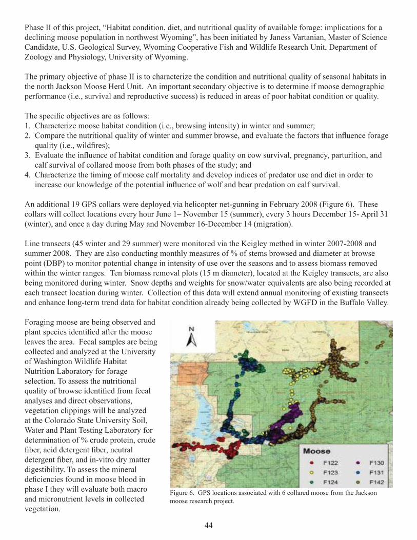
44
Phase II of this project, “Habitat condition, diet, and nutritional quality of available forage: implications for a declining moose population in northwest Wyoming”, has been initiated by Janess Vartanian, Master of Science Candidate, U.S. Geological Survey, Wyoming Cooperative Fish and Wildlife Research Unit, Department of Zoology and Physiology, University of Wyoming.
The primary objective of phase II is to characterize the condition and nutritional quality of seasonal habitats in the north Jackson Moose Herd Unit. An important secondary objective is to determine if moose demographic performance (i.e., survival and reproductive success) is reduced in areas of poor habitat condition or quality.
The specifi c objectives are as follows: 1. Characterize moose habitat condition (i.e., browsing intensity) in winter and summer;2. Compare the nutritional quality of winter and summer browse, and evaluate the factors that infl uence forage quality (i.e., wildfi res);3. Evaluate the infl uence of habitat condition and forage quality on cow survival, pregnancy, parturition, and calf survival of collared moose from both phases of the study; and4. Characterize the timing of moose calf mortality and develop indices of predator use and diet in order to increase our knowledge of the potential infl uence of wolf and bear predation on calf survival.
An additional 19 GPS collars were deployed via helicopter net-gunning in February 2008 (Figure 6). These collars will collect locations every hour June 1– November 15 (summer), every 3 hours December 15- April 31 (winter), and once a day during May and November 16-December 14 (migration).
Line transects (45 winter and 29 summer) were monitored via the Keigley method in winter 2007-2008 and summer 2008. They are also conducting monthly measures of % of stems browsed and diameter at browse point (DBP) to monitor potential change in intensity of use over the seasons and to assess biomass removed within the winter ranges. Ten biomass removal plots (15 m diameter), located at the Keigley transects, are also being monitored during winter. Snow depths and weights for snow/water equivalents are also being recorded at each transect location during winter. Collection of this data will extend annual monitoring of existing transects and enhance long-term trend data for habitat condition already being collected by WGFD in the Buffalo Valley.
Foraging moose are being observed and plant species identifi ed after the moose leaves the area. Fecal samples are being collected and analyzed at the University of Washington Wildlife Habitat Nutrition Laboratory for forage selection. To assess the nutritional quality of browse identifi ed from fecal analyses and direct observations, vegetation clippings will be analyzed at the Colorado State University Soil, Water and Plant Testing Laboratory for determination of % crude protein, crude fi ber, acid detergent fi ber, neutral detergent fi ber, and in-vitro dry matter digestibility. To assess the mineral defi ciencies found in moose blood in phase I they will evaluate both macro and micronutrient levels in collected vegetation.
Figure 6. GPS locations associated with 6 collared moose from the Jackson moose research project.

45
Upper Crow Creek Spawning and Migration ProjectEnhancing native cutthroat trout spawning and migration in Salt River tributaries is an ongoing watershed
enhancement effort. The WGFD is striving with cooperators, interest groups, land managers, and landowners to promote watershed function and ecosystem integrity by enhancing the quality and diversity aquatic habitats in Salt River tributaries.
Crow Creek is a Salt River tributary that originates in Idaho and provides approximately 8 miles of important spawning and rearing habitat for Snake River cutthroat trout. Most of this key habitat occurs on privately held land and habitat improvements will enhance spawning, migration, rearing, and adult habitat. Modifi cation and manipulation of the Crow Creek channel is needed to enhance trout migration and improve habitat diversity. There are few pools and riffl es, little overhead cover, the stream bottom is inundated with sediment, and gravels are buried in silt. An enhancement project has been developed to provide sustainable pools, overhead cover, and spawning and migration routes for native Snake River cutthroat trout. These habitats are critical for maintaining wild populations of Snake River cutthroat trout.
Objectives:• Maintain meander pattern to preserve stream structure;• Maintain spawning and migration habitat for trout;• Reduce sediment contribution of eroding banks;• Enhance aquatic habitats to maximum ecological potential;• Enhance riparian habitats to maximum ecological potential; and• Provide suffi cient habitat and habitat diversity to increase Snake River cutthroat trout populations.
A landowner near the Wyoming headwaters of Crow Creek funded and implemented the fi rst phase of the project during the fall of 2008. Six tree revetments were placed along the stream bank to provide overhead cover (Figure 7). Washed gravels were added to areas for spawning habitat. Finally, fi fteen pools were excavated (Figure 8). Additional work is scheduled for the late fall/winter 2009. Four cross vane structures are planned to stabilize this reach of Crow Creek. Revegetation is scheduled for spring 2010.
Figure 7. Placement of tree revetment structure on upper Crow Creek.
Figure 8. Tree revetment structure in a jackstraw formation.

46
Greys River Aspen InventoryThe Greys Ranger District of the BTNF and WGFD partnered to initiate a comprehensive aspen inventory
throughout the entire Ranger District in 2008. Initial project funding ($45,000) was granted to the B-T Forest from the WLCI. The goal of this project is to provide an accurate account of aspen distribution and condition status of aspen stands for future enhancement treatments in the Greys River Ranger District.
Project Objectives include:1. Refi ne the currently documented distribution of aspen on the district;2. Determine the locations and condition of aspen stands on the district; 3. Identify, in priority order, the stands drainages or portions of drainages that are in most need of treatment with respect to conditions in aspen stands; and4. Provide the above aspen stand information in GIS format supported with a narrative report which will facilitate managers in the development and implementation of aspen enhancements on a Ranger District scale.
Each aspen stand was described according to community type, over and understory dominance, risk factors and treatment priority. Technicians mapped 629 aspen stands, in which 44 different community types were encoun-tered (Figure 9). Of the total stands, 37% were classifi ed as highest priority for treatment. The inventory is currently 50% complete and a preliminary report addressing the 2008 activities has been completed.
Initial WLCI funds ($45,000) will not be suffi cient to complete the systematic comprehensive aspen inventory. We estimate that an additional $21,000 will be required for completion in 2009 and funds were solicited during the 2009 funding cycle.
Figure 9. Illustration of aspen stand location and priority for treatment along the Greys and Salt Rivers, as identifi ed by the Greys River aspen inventory, 2008.

47
Bradley Mountain Prescribed Burn Vegetation TreatmentThe Greys River Ranger District of the BTNF, WGFD, WWNRT and other potential partners are proposing
a prescribed burn on Bradley Mountain. The area consists of important elk and moose transition/winter range. This area is located just east of Alpine, Wyoming and along the eastern bank of the Greys River. The proposed treatment consists of 4,300 acres and managers expect to apply fi re to approximately 20-40% of the area. Some portions will not carry a fi re due to precipitous terrain, thin soils and sparse vegetation. Mechanical treatments may be used to supplement prescribed burning in some areas.
The burn was not implemented in 2008 due to a backlog of other habitat enhancement projects. Implementation is proposed for the spring/fall of 2009. Burn units were in-ventoried, habitat/cover type mapped and priority areas identifi ed by WGFD and FS personnel (Figure 10).
OTHER SIGNIFICANT ACCOMPLISHMENTS
• Over six miles of Murphy Creek in the Greys River watershed were inventoried using WHAM Level 1.
• Attended ’88 Yellowstone Fires and Beyond Conference in Jackson.
• Inventoried, identifi ed on a map, and coordinated fi sh passage issues on Spring Creek south of Jackson.
• Assisted in a habitat evaluation for Karns Meadow Wetland on Flat Creek. This project is proposed to address urban storm water.
• Coordinated and prepared Jackson Aquatic Priorities for the Strategic Habitat Plan with region, administration, and GIS section.
• Participated, with Jackson Region personnel, in the preparation of the Alpine Wetland and South Park WHMA Five Year Management Plan.
Figure 10. The Bradley Mountain project area is located just east of Alpine and is approximately 4,300 acres.

48
LANDER REGION
HABITAT PROJECTS
Lander Front Habitat Improvement ProjectWork continued in 2008 on the fi rst phase of the Lander Front Mule Deer Habitat Im-
provement Project. Four hundred ninety-nine acres of juniper were treated this year, bring-ing the total to 1,165 acres treated thus far. The contractor will return in 2009 to continue treating juniper until funds are exhausted. BLM lands that will be treated next year have already been cleared so work will be able to begin as soon as the winter range stipulations end. Transects that were established in 2007 prior to treatment were re-read with positive results. Bare ground decreased, while litter, forbs and grasses increased (Figures 1a and 1b). Spike was aerially applied to 2,567 acres of sagebrush on 7 private landowners and BLM lands in October 2008. Monitoring transects were established in each area and will be re-read next year to observe the effects of the herbicide. The monitoring transect in the sagebrush mowing conducted in 2007 was re-read with positive results. Shrub density and bare ground decreased, while grass and forb density increased. Two wells were upgraded to solar arrays in 2008, however the required fencing has yet to be completed. Fencing should be completed this winter.
Planning for the next phase of the project began in 2008. Reconnaissance was completed on Beaver Creek to determine the extent and location of saltcedar and Russian olive. Juniper stands were selected for thinning and sagebrush stands were examined to determine the best locations for treatments, which will include mowing and herbicide. All landowners on Beaver Creek were contacted about the project and have agreed to allow access to contrac-tors and rest treatments from grazing for at least 1 growing season. Funding was acquired from the WWNRT in the amount of $174, 388. Additional funds will be applied for in 2009.
• Red Butte conserva-tion easements were completed.
• 114 acres of sagebrush were mowed on Red Rim WHMA.
• 850 acres of Rx burns were com-pleted.
• 2,567 acres of sagebrush and 499 acres of juniper were treated for the Lander Front Mule Deer project.
• 41 Yellowstone cutthroat trout were radio tagged and will be tracked for one year in the East Fork drainage of the Wind River.
• 4 fi sh entrainment investigations were conducted on Bear Creek.
• 30 yards of rock were used to
maintain 4 Gabion structures and improve 1 mile of stream in Cottonwood drain on Sand Mesa WHMA.
• 2 Sheet-piling structures were repaired in Red Canyon creek on Red Canyon WHMA.
• Approximately 20 trees and 9 large stumps were sunk in Boysen Reservoir to increase aquatic habitat.
Figures 1a and 1b. Before and after photos of a 2007 juniper treatment.

49
Yellowstone Cutthroat Trout Telemetry StudyTrout Unlimited (TU), WGFD, and the Shoshone National Forest (USFS) have identifi ed fi sh movement
as a key factor to better understanding the status of native Yellowstone cutthroat trout in the East Fork Drainage of the Wind River near Dubois. Systematically studying fi sh movement patterns should lead to a better under-standing of life history needs for native trout, and help identify, design, fund, and implement potential conserva-tion alternatives in the future. This cooperative project was designed to address the following objectives: 1. Identify Yellowstone cutthroat trout winter habitat and movements in the East Fork Wind River drainage;2. Identify spawning habitat and time of migration to these areas;3. Determine cutthroat trout movement patterns associated with storm events, spring runoff, and the summer season; and4. Assess cutthroat trout entrainment in irrigation systems as they move throughout the watershed.
Members of WGFD, TU, and Gregory Aquatics captured and radio tagged (Figure 2) 41 Yellowstone cutthroat trout in the East Fork drainage on September 30th and October 1st, 2008. Another 20 fi sh will be captured and tagged in early 2009. Fish have been located monthly since October and tracking will continue through the fall of 2009.
Preliminary tracking data from October thru December has shown most fi sh inhabiting pools associated with large woody debris and/or boulders. The longest movement recorded so far was roughly 2.5 miles, while most fi sh have scattered within a ½ mile from the release site where they were radio tagged (Figure 3).One fi sh has never been found since tagging, two are presumed dead, while three have not been located in November or December.
Shrub Production/Utilization MonitoringRegional wildlife personnel collected
utilization and production data at 5 established shrub transects and added an additional 4 tran-sects this fall. Utilization over the 2007-2008 winter was relatively low at all transects, rang-ing from 5-30%. Most transects were below 20% utilization, probably because deep snow protected the majority of the plants from be-ing overused. Fall production increased at all sagebrush transects with an average of 24 mm at existing transects, up from 16 mm in 2007.Bitterbrush production, however, decreased from 86 mm to 63 mm. This decrease may have been caused by dry summer conditions.
Figure 2. Yellowstone Cutthroat undergoing surgery to implant the radio tag.
Figure 3. December GPS locations of 10 Yellowstone cutthroat trout in the Wiggins Fork of the East Fork drainage. The orange square represents the release site for all 10 fi sh in September 2008 after surgery.
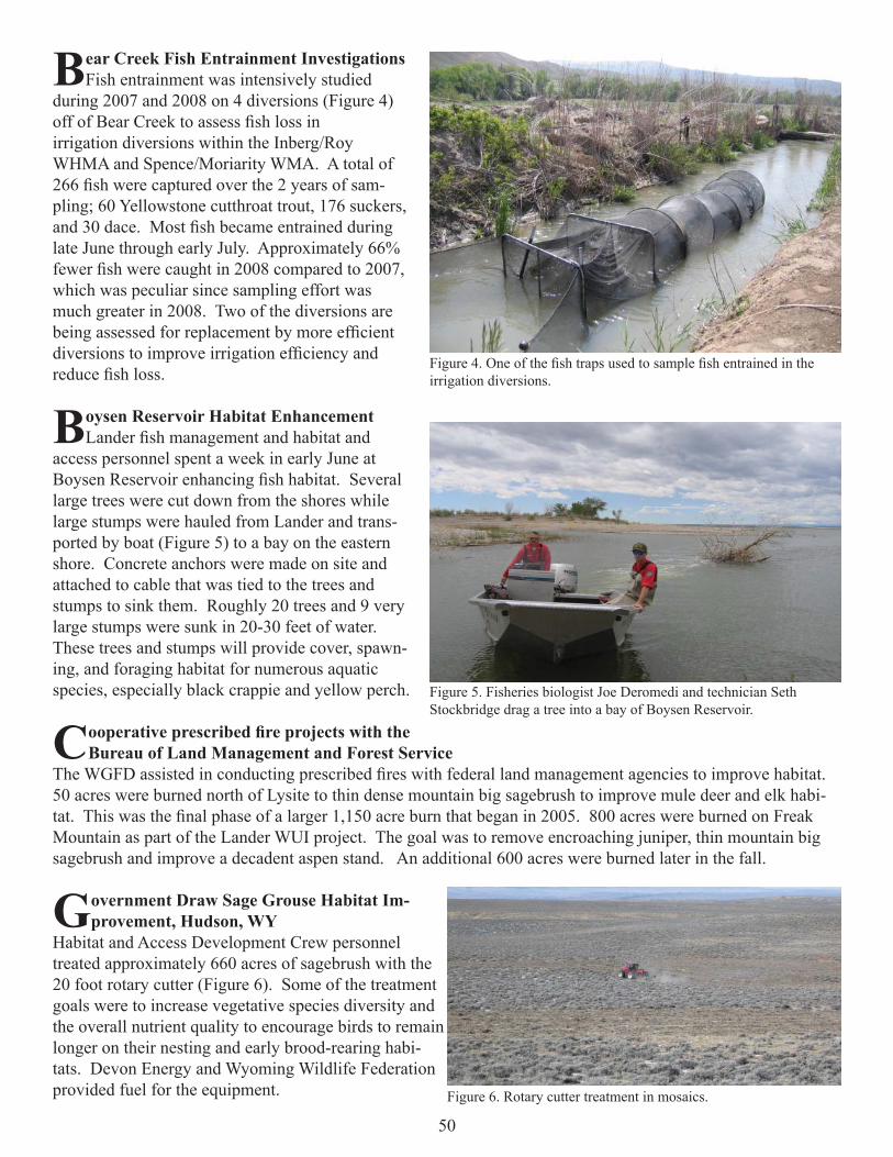
50
Bear Creek Fish Entrainment InvestigationsFish entrainment was intensively studied
during 2007 and 2008 on 4 diversions (Figure 4) off of Bear Creek to assess fi sh loss in irrigation diversions within the Inberg/Roy WHMA and Spence/Moriarity WMA. A total of 266 fi sh were captured over the 2 years of sam-pling; 60 Yellowstone cutthroat trout, 176 suckers, and 30 dace. Most fi sh became entrained during late June through early July. Approximately 66% fewer fi sh were caught in 2008 compared to 2007, which was peculiar since sampling effort was much greater in 2008. Two of the diversions are being assessed for replacement by more effi cient diversions to improve irrigation effi ciency and reduce fi sh loss.
Boysen Reservoir Habitat EnhancementLander fi sh management and habitat and
access personnel spent a week in early June at Boysen Reservoir enhancing fi sh habitat. Several large trees were cut down from the shores while large stumps were hauled from Lander and trans-ported by boat (Figure 5) to a bay on the eastern shore. Concrete anchors were made on site and attached to cable that was tied to the trees and stumps to sink them. Roughly 20 trees and 9 very large stumps were sunk in 20-30 feet of water. These trees and stumps will provide cover, spawn-ing, and foraging habitat for numerous aquatic species, especially black crappie and yellow perch.
Cooperative prescribed fi re projects with the Bureau of Land Management and Forest Service
The WGFD assisted in conducting prescribed fi res with federal land management agencies to improve habitat. 50 acres were burned north of Lysite to thin dense mountain big sagebrush to improve mule deer and elk habi-tat. This was the fi nal phase of a larger 1,150 acre burn that began in 2005. 800 acres were burned on Freak Mountain as part of the Lander WUI project. The goal was to remove encroaching juniper, thin mountain big sagebrush and improve a decadent aspen stand. An additional 600 acres were burned later in the fall.
Government Draw Sage Grouse Habitat Im-provement, Hudson, WY
Habitat and Access Development Crew personnel treated approximately 660 acres of sagebrush with the 20 foot rotary cutter (Figure 6). Some of the treatment goals were to increase vegetative species diversity and the overall nutrient quality to encourage birds to remain longer on their nesting and early brood-rearing habi-tats. Devon Energy and Wyoming Wildlife Federation provided fuel for the equipment.
Figure 4. One of the fi sh traps used to sample fi sh entrained in the irrigation diversions.
Figure 5. Fisheries biologist Joe Deromedi and technician Seth Stockbridge drag a tree into a bay of Boysen Reservoir.
Figure 6. Rotary cutter treatment in mosaics.

51
WILDLIFE HABITAT MANAGEMENT AREAS
Whiskey Basin WHMAThe 2007-2008 over winter herbaceous utilization was 67%, the highest in 4 winters. The high use
was likely caused by poor production in 2007 and a hard, cold winter which held bighorn sheep and elk on the winter range longer than normal. Fall production was 366 lbs/acre, up from 291 lbs/acre in 2007. Production inside and outside range pitting completed in 2007 was also compared to determine the effects of the treatment. Herbaceous production in the treated areas was 6 - 67% higher than non-treated areas showing a neutral to posi-tive result (Figures 7a and 7b). More clipping will be completed next year.
Spence/Moriarity WMA and Inberg/Roy WHMAHerbaceous production on the Spence/Moriarity WMA increased to 189 lbs/acre, up from 108 lbs/acre in
2007. Production on Inberg/Roy WHMA also increased from 108 lbs/acre to 233 lbs/acre. The 2007-2008 over winter utilization was extremely high on both units, 77% on Spence/Moriarity and 90% on Inberg/Roy. The high utilization was likely caused by very low production in 2007 and a long, cold winter that kept elk on the units longer than normal. Because of the lack of forage, the elk moved east onto the Wind River Reservation as expected, but we did not have many damage issues on private property.
The southern one-third of Thunderhead Meadow at Spence/Moriarity WMA was replanted and the gated pipe system was expanded. This resulted in increased forage production and utilization by winter elk from the East Fork herd. Additionally, a portion of Firehouse Meadow was aerated to reduced soil compaction and increase forage production.
Cottonwood Drain Riparian Maintenance/ImprovementWith the assistance of the Habitat and Access crew, four gabion structures were repaired with rock in
Cottonwood drain of Sand Mesa WHMA. The gabions were installed approximately 30 years ago to catch sedi-ment, raise the water table, and stop some areas of severe down cutting. Maintenance activities had occurred once since then by adding new gabions on top of the original structures. The goal this year was to replace the gabions with sheet piling since they will last much longer. However, the soil was too hard for the sheet piling to be driven into the ground. As a result, loads of rocks were used to harden the creek bottom and banks of the gabion structures to reduce erosion around the structures and provide more support. Leftover rock was used to harden banks to reduce erosion and help establish vegetation.
Red Rim WHMAHerbaceous production on the Red Rim WHMA was phenomenal in 2008, up to 960 lbs/acre from 216 lbs/
acre in 2007. Most of the growth was in the meadows, however the uplands improved as well. Green line tran-sects established in 2001 were reread in 2008. Willow distribution has greatly increased in 7 years and appears to be expanding.
Figures 7a and 7b. Photos inside and outside of range pitting project.

52
The Habitat and Access Maintenance Crew com-pleted a sagebrush-thinning project on the WHMA. They mowed 114 acres within a 280 acre polygon (Figure 9). The goal of the mowing was to break up a dense, old growth big sagebrush stand to increase herbaceous production. The area is used by sage-grouse during brood rearing and increased forbs should benefi t chick survival.
Another elk die-off occurred on the WHMA this winter with at least 89 animals perishing. Regional personnel attempted to bait elk away from areas with high levels of the lichen Xanthoparmeliachlorochroa, the presumed cause of the die-off, to no avail. The State Vet Laboratory continued to research the phenomenon by taking samples from euthanized animals. No new theories have been developed.
Red Canyon Creek Riparian MaintenanceSheet piling structures were installed on Red Canyon Creek within the Red Canyon WHMA in 2003 to
improve the riparian area by catching sediment, raising the water table, and establishing wetland vegetation.Monitoring of the structures this year revealed that 2 were in need of repair. One leak was fi xed by placing sandbags within the sheet piling. The other structure had blown out on one side (Figure 9) so additional sheet piling was used to extend the structure across the stream channel. The structure was extended roughly 12 feet further until it reached a high terrace (Figure 10). Water again pooled up and migrated back to where it was designed to breach the sheet piling and rocks could dissipate the energy of the falling water.
Sand Mesa WHMAThe Wyoming Honor Farm crew began work to clear 0.3 miles of Fivemile Creek of Russian olive as an
experiment, however they did not complete the work. The goal was to remove olives and plant native species including willow, cottonwood, silver buffaloberry and golden currant to provide pheasants a native source of forage and cover. If the plantings take hold and it can be determined that pheasants are using them, then we can continue to remove olives along the entire drainage. Students from Shoshoni High School assisted in planting 900 seedlings. Many of the seedlings were washed away in the high fl ow or were shaded out by dense rushes,
Figure 8. Sagebrush mowing on the Red Rim WHMA.
Figure 9. The riparian structure prior to repair looking upstream; the stream channel had washed out around the right edge.
Figure 10. The structure after extending the sheet piling across the stream channel.

53
however some did survive through the summer. The Fremont County Weed and Pest began treating saltcedar along Muddy Creek using a basal bark treatment with the herbicide Remedy Ultra. They completed Muddy Creek, but funds ran out before they could fi nish Fivemile Creek. Funds will be obtained and spraying on Fivemile Creek will be completed in 2009.
During the spring of 2007, the fi rst of three pivot sprinklers was replaced at Sand Mesa WHMA. The remaining two pivots were replaced in the spring of 2008. Simultaneously, a fi ve-year farming lease was awarded. The pivot fi elds were planted in barley and wheat during 2008; this effort was associated with increased fall water-fowl use.
Red Canyon WHMAHerbaceous production on the Red Canyon WHMA increased from 394 lbs/acre in 2007 to 582 lbs/acre
in 2008. The 2007-2008 over winter utilization could not be determined because of the late spring snow pack. However, it appears that utilization is light to moderate.
As a cooperating partner in the Red Canyon Ranch CRM, the Department allowed the ranch to graze the irrigated meadows this spring. Issues with the electric fence prohibited the full use of the meadows, however the cattle did remove a large portion of the old, rank grass. The meadows will be monitored in 2009 to deter-mine the effects of the grazing.
Approximately 450 cows from the Red Canyon Ranch (The Nature Conservancy) and the Red Canyon CRM spent fi ve and one-half days on the upper and east meadow of Red Canyon WHMA in late May. The mead-ows were grazed in order to eliminate much of the accumulated decadent vegetation. This will simultaneously increase forage vigor and palatability, and lead to increase use of the meadow by wintering elk of the Southern Wind River herd.
OTHER SIGNIFICANT ACCOMPLISHMENTS• Conducted level I WHAM survey on Strawberry Creek, which is a tributary to the Sweetwater River. The
watershed encompasses approximately 12 stream miles and 23,676 acres. • Assisted with revision of the SHP with fi sh management and the terrestrial habitat biologist. Developed
several joint crucial and enhancement habitat areas that include both aquatic and terrestrial habitat goals and concerns.
• Participated in cooperative monitoring of Split Rock Ranch with the BLM, ranch managers, and conserva-tion partners to assess upland and riparian habitat conditions throughout the grazing season. Upland use was minimal with excellent grass and shrub production this year. Some riparian areas did not meet the residual vegetation criteria set by the BLM. Several areas of Sage Hen Creek could use rehabilitation of the riparian vegetation and function.
• Reviewed BLM documents and attended several cooperator meetings to assist with revision of the Lander RMP. Some of the resources discussed to date include biological, grazing, minerals and leases, and water resources.
• Assisted Wyoming Stock Growers Ag Land Trust with a Doris Duke grant application for a conservation easement on the Hovendick property located east of Lander along the Popo Agie River.
• Stream temperature and Ocean Lake drain monitoring was continued. • Worked with the USFS and WGFD out of Pinedale on establishing a grassbank for the Blair Creek habitat
area along the upper Sweetwater river. Toured the area by horseback and began developing a strategy to establish guidelines for its use.
• Participated in the Red Canyon Ranch and Tony Malmberg CRMs.• Participated in the Lander BLM RMP revision.• Assisted in the Split Rock Ranch and Green Mountain Allotment Cooperative Monitoring.• Participated in the mule deer working group.

54
LARAMIE REGION
HABITAT PROJECTS
Laramie River Greenbelt EnhancementSeveral years ago, $18,000 (WYDEQ fi ne money) was donated to WGFD to address
aquatic habitat issues in the upper Laramie River. Several habitat concerns have been iden-tifi ed in the Laramie River through Laramie including bank erosion, low summer fl ows, and lack of deep pools and cover for fi sh. The Laramie River through town supports a wild brown trout fi shery and several native, non-game species including brassy minnow and com-mon shiner. In 2007, the Aquatic Habitat Biologist began working with the Laramie Rivers CD and the Laramie Beautifi cation Committee to develop project ideas for use of these donated funds in the Laramie River.
In 2008, additional funds were raised by the partners for the Laramie River Greenbelt En-hancement project to hire hydrological and engineering consultants for the design phase.The partners for the project include the City of Laramie, Laramie Rivers CD, Laramie Community Foundation – Laramie Beatifi cation Committee, Albany County Commissioners, Groathouse Construction, Laramie Rotary Club, American National Bank, UW, and WGFD. In August 2008, the Laramie Beautifi cation Committee hired Habitech, Inc. and WWC En-gineering for the design and permitting process of the project. The current focus area of the project includes approximately 3.5 stream miles and is from the I-80 bridge downstream to the water treatment facility. Additionally, several meetings were attended throughout the fall regarding data collection and design ideas. The fi nal design plan will be fi nished in winter 2009, and the partners will apply for grant funding for project implementation.
Lower Laramie River ProjectAssessments and planning
continued on the Laramie River at a private ranch west of Wheatland. Approximately one mile of the river fl ows through the property, and the riparian habitat is currently under the CCRP for the next 9 years. The owners are interested in improving instream habitat for fi sh, in particu-lar trout. Low trout abundance has been recorded in the reach, but several native species inhabit this portion of the Laramie River, in-cluding hornyhead chub (SGCN), Johnny darter, and stonecat. In 2008, detailed channel morphology data were collected throughout the reach including cross-sections, pebble counts, and a longitudinal profi le. Additionally, two temperature loggers were placed in the reach to record summer water temperatures.
The reach is within the transition zone as the Laramie River exits the Laramie Mountains and fl ows onto the plains. The reach had both B and C Rosgen channel types. Overall, the stream was stable and there was no streambank erosion, but it had a high width/depth ratio. There were also three long, wide pool seg-ments (250 to 675 feet in length) with excess fi ne sediments (Figure 1). The maximum temperature recorded in
• Wick WHMA short duration high inten-sity livestockgrazing treat-ments conducted on irrigated meadows.
• Grazing manage-ment assistance to producers infl uencing managementon more than 93,000 acres.
• 730 acres of Russian Olives managed thru mechanical and herbicide
treatments.
• Over 13 miles of stream were in-ventoried on the Pennock Moun-tain WHMA and adjacent USFS lands.
• 5 beaver trans-planted from the east face of Elk Mt. to South Lake Creek on Pennock WHMA.
Figure 1. Laramie River within the transition zone near Wheatland.

55
the reach was 82oF in late July and early August. Habitat improvement will focus on narrowing and deepening the channel to help move excess fi ne sediments in the reach and lower summer water temperatures. Enhance-ments will also create habitat diversity for fi sh within the reach.
Crow Creek – Griffi n Park ProjectTwo hotels, a new park, and the extension of the Crow Creek Greenway were slated for construction in
Cheyenne on a parcel of land between I-25 and Westland Road in 2008. The Aquatic Habitat Biologist collect-ed preliminary channel morphology data for this reach of Crow Creek in 2007 for a habitat enhancement project to coincide with the development project. Due to the weakened economy in 2008, the hotel, park and Greenway extension were temporarily put on hold.
The delay in construction provided additional time for data collection and project planning for habitat improve-ment in Crow Creek. In 2008, meetings were held with potential project partners, Laramie County Conserva-tion District (LCCD) and TU. LCCD planned to investigate biological control alternatives for leafy spurge. Currently, goats are used during the summer to suppress this invasive species along Crow Creek. TU planned to gain access for private land through the reach. The Aquatic Habitat Biologist worked to collect data to develop a habitat enhancement design for the reach.
Detailed channel morphology data were collected in Crow Creek at the Griffi n Park site from I-25 downstream 800 feet to a private land boundary. The reach surveyed was classifi ed as a C4 channel, and approximately half of the reach surveyed was straight, wide, and lacked deep pool habitat. Data not collected from the private land boundary downstream to Westland Road, as access has not yet been obtained for portions of this segment. Habitat plans for the reach will focus on improving riparian vegetation and narrowing and deepening the chan-nel to enhance fi sh habitat and increase movement of fi ne sediments through the reach. Additionally, a tempera-ture logger was placed in the reach and recorded stream temperatures every 30 minutes from May 20 through October 12, 2008. The maximum temperature recorded was 82.1oF on July 4. Overall, July had the warmest temperatures recorded throughout the period.
Crow Creek Wetland Construction ProjectThis project was initiated in 2007 with the construction of three wetland complexes, continued in 2008
with planting of riparian vegetation and construction of fencing (Figure 2) and will conclude in the spring of 2009 with additional riparian planting. Tree plantings consisted of cottonwood, ash, juniper, and crab apple. A 1-acre shrub plot was planted and consisted of chokecherry, American plum, saltbush, buffalo berry, and wild rose (Figure 3). Monitoring will occur annually through at least 2011. In total, approximately 2 acres of new wetlands were constructed and nearly three thousand trees and bare root shrubs were planted by almost 50 volunteers. One and a half miles of stream were fenced on both sides to exclude livestock. This created a third rotational pasture along the creek. Fish population monitoring within the study area showed that non-game fi sh populations had increased slightly from pre-project conditions however increased fi sh species diversity has not been observed. The wetland complexes were heavily used by waterfowl during the spring migration period.
Figure 2. Completed wetland and cottonwood trees. Figure 3. Planted riparian shrub cover and food plot.

56
Large scale, landscape watershed level projects completed by the Habitat Extension Biologist:• The Department’s SHP priority areas for southeastern Wyoming was revised with input from conservation
partners, landowners, and WGFD personnel.• Assisted with radio telemetry tracking of Mon-
tana transplanted bighorn sheep in the Laramie Range, and radio collar retrieval in Fall 2008.
• Provided information to potential wind energy developers, private landowners, and conser-vation partners on impacts of wind energy to wildlife habitat.
• Assisted in development of the WY WHIP pro-gram, resurrecting the Department’s successful private landowner habitat grants program from the late 1990’s.
• Continuation of monitoring of shrub habitat conditions, annual production and utilization rates within the Laramie Range foothills and Goshen Rim on 18 transect locations.
• Created GIS maps of prescribed fi re and wild-fi re areas within the Laramie Range, utilized to help with interpretation of the bighorn sheep trap, transplant, and radio-collar project results.
• Continued participation on the Platte County Russian Olive Task Force (Figure 4 and 5). Responsible for much of the on-the-ground monitoring of project effectiveness, building treatment prescriptions, and coordinating with landowners, private contractors, conservation partners, and herbicide companies on projects.
• Conducted prescribed burns on 2,000 acres Richeau Hills mixed shrubs (Figure 6), 800 acres Jay Em, WY CRP tract, and 200 acres Slater, WY CRP tracts, with planning being conducted on an additional 6,510 acres on Iron Mt. and Sugar Loaf Mt. for 2009.• Continued providing assistance to CSU graduate
students studying the effectiveness of previous and planned cheatgrass control herbicide projects.
• Continued to serve as the state coordinator for WFW Foundation and Western United States project advisor.
• Assisted producers with development of livestock grazing management plans for more than 93,210 acres on 14 ranches.
• Provided technical assistance to agricultural produc-ers and local Farm Service Agency offi ces on man-agement of thousands of acres of CRP lands affected by noxious weeds and insect outbreaks in 2008.
Figure 4. Russian olive removal in Sybille Creek riparian area.
Figure 5. Russian olive aerial herbicide application, September 2008.
Figure 6. October 2008, Helit-torch ignition prescribed burn in Richeau Hills.

57
Habitat Based Population Objectives – Medicine Bow Pronghorn Prototype.Additional work is scheduled for 2009.
Southeast Wyoming Cheatgrass PartnershipCSU personnel Cini Brown and Marques Munis have study plots in several locations in SE Wyoming. The
study will continue for several more years.
The BLM has completed the EIS needed to be able to spray Plateau and other herbicides aerially. However, the USFS has not completed an EIS for aerial application.
The group has scheduled meetings for 2009.
Comprehensive Management Plan for the Platte Valley Mule Deer HerdThe TSS was able to complete assessment of mule deer habitat in the contracted focus areas totaling
225,000 acres during the summer and fall of 2008. The draft report was received before the end of the year, and suggested edits and comments were provided.
Helicopter fl ights are planned for 2009 to do an actual population estimation.
2008 Production and Utilization SurveysGame wardens and population biologists assisted with collecting production and utilization information at
approximately 20 of the Laramie Region’s 55 pronghorn and mule deer shrub winter range monitoring stations. The regional habitat biologist was physically unable to read the remainder. Of those that were measured, pro-duction was similar to the year before in many places. It appears that the winter of 2008-09 will not be severe on winter ranges, and survival of big game should be good.
Alsop Lake Water AcquisitionNegotiations were completed and an agreement was written to purchase enough water to raise the lake to
an elevation of 7,145 feet (about 100 acre-feet) in exchange for $4,500. This is a one-time payment for a one-time fi ll that is scheduled to occur in the winter or spring of 2009 as conditions permit.
Red Mountain Project Department involvement in this project began in 2004. A project update has been included in the previous
three annual reports.
In 2008 BLM crews were able to complete planned encroaching conifer removal and limber pine machine mas-tication projects. Livestock were excluded from wet meadows using electric fences. All that remains is brush-beating and interseeding with a seed mix designed to benefi t sage-grouse.
Mountain Pine Beetle Mountain Pine beetles continue to expand to new areas and increase the percentage of trees killed within
previously impacted areas. The winter of 2008-09 doesn’t appear to have the temperatures needed to kill the insects, so it is looking more like the irruption will only end when the food supply is gone. The coming years will see many changes to the forests in the region.

58
HABITAT EXTENSION SERVICES
Habitat EnhancementsIn 2008, over 70 major landowner contacts and fi eld visits were made resulting in some level of project
level assistance. Technical and cost share assistance was provided to private landowners who implemented projects including: permanent cover seedings, native and introduced species (Figure 7), water developments for livestock and wildlife (Figure 8), CRP management, prescribed burning in mountain shrub and CRP habitats, noxious vegetation (woody and herbaceous) management in riparian and upland areas, wetland restoration, food plots for game birds, and in-stream fi sheries habitat.
Project TotalsType # Acres CRP Management 7 5,600 Permanent Cover Seedings 13 3,530Russian Olive Removal / Management 10 530Grazing Management Planning 14 93,210Water Developments 10 N/AWetland Development / Restoration 6 N/ARiparian Enhancement (CCRP) 1 63 acres, 2 milesInstream Fisheries Habitat Inventory 2 1 mileCheatgrass Management / Herbicide Application 2 1,400 acresPrescribed Fire (blackened) 3 3,000 acresPrescribed Fire (planned) 3 6,510 acres
WILDLIFE HABITAT MANAGEMENT AREAS
Pennock Mountain WHMA Watershed SurveysWHAM Level 1 surveys were conducted on the Pennock Mountain WHMA and adjacent USFS lands
during summer 2008 in the South Fork Lake Creek watershed (HUC 101800020605). Over 13 miles were surveyed on the following streams: Deer Creek, Goetz Creek, South Fork Goetz Creek, and South Fork Lake Creek. The headwaters for these streams are perennial, and fl ow out of steep, narrow drainages located in the Medicine Bow National Forest on the west side of Pennock Mountain. As the streams exit the mountains and fl ow into the sagebrush lowlands, the water goes sub-surface (Figure 9). In 2001, a large fl ood impacted South Fork Lake Creek. Subsequently, beaver and brook trout disappeared from the reach. Beaver have been re-introduced into South Fork Lake Creek over the past 2 years and have established several ponds.
Figure 7. Wheat strip conversion to permanent grass legume cover. Comparison of use of cover crops (right) in fallow strips and no-till seeding into stubble (left) following herbicide application, Spring 2008.
Figure 8. 750 gallon guzzler tank installation in Platte County CRP tract.

59
It is recommended that brook trout be stocked into the newly established beaver ponds of South Fork Lake Creek. A brief administrative report detailing observations and management recommendations of the surveyed drainages will be completed in the next few years.
Pennock Mountain Beaver TransplantA contractor was hired to trap as many
beaver as possible, to a maximum of 11, for transplant into upper South Lake Creek, near the Edward’s homestead on the Pennock Mountain WHMA. The contractor, who was instructed to take the beaver from the Aspen Highlands area of Elk Mountain, was able to provide 5 beaver that were transplanted.
Wick WHMAThis was the fi rst year of a trial fall
cattle-grazing treatment on the hay meadows.The treatment was conducted in September. The treatment is designed to provide an area of early spring forage growth for elk. This for-age maintenance-grazing plan used 360 head of cattle to treat 100 acres of grass hay meadows.The Sims Cattle Company provided the person-nel, livestock, electric fences, monitoring and herding of the cattle 24 hours per day during the fourteen-day grazing treatment. The cattle were contained with electric fencing on treatment paddocks of twenty to fi fty acres in size. The grazing effectiveness is monitored against predetermined utilization goals. When the vegetative treatment goal is reached, the cattle and fences are moved from paddock to paddock. The grazing treatment focus is to remove old growth, specifi c noxious weeds and to stimulate higher quality regrowth of standing forage for big game, particularly elk (Figure 10).
Figure 9. Dry segment of South Fork Lake Creek on Pennock Mountain WHMA during 2008 WHAM Level 1 surveys.
Figure 10. Bull elk tangled in high tensile wire during livestock grazing treatment at Wick WHMA, September 2008.

60
OTHER SIGNIFICANT ACCOMPLISHMENTS
• Participated in the Mule Deer Working Group and assisted with Platte Valley Mule Deer Plan.• Helped with Platte Valley landowner meeting, toured Upper Cedar Creek ranch with owner, submitted • project proposals for WWNRT fall deadline, and toured proposed projects with WWNRT representatives.• Helped revise the Laramie Region SHP polygons and narratives for the latest Strategic Habitat Plan. • Toured region with Video Coordinator Greg Hallen for the 2009 season-setting meeting DVD on habitat.• Participated in a media tour developed by the I&E supervisor focused on informing the public of current
mule deer and pronghorn winter range habitat conditions and the need to manage these animals within the carrying capacity of the range.
• Met with Belvoir Ranch managers and toured the area with personnel from the Laramie County CD and discussed land management options that could improve the site for wildlife.
• Discussed graduate research project proposal with University of Wyoming researchers concerning the relationships between beaver ponds and woody vegetation dynamics on Pole Mountain.• Toured the Lower Laramie watershed with Colorado State University researcher and student working on a
graduate research project on hornyhead chub in the watershed.• Provided stream trailer demonstrations at the Albany County Conservation Expo.• Annual maintenance was completed on four riparian exclosures on South Fork Middle Crow Creek with as-
sistance from the USFS and Izaak Walton League.• Continued to monitor habitat improvement projects in the North Platte River and Crow Creek.• 17 formal educational programs were conducted. Over 605 individuals heard presentations on topics rang-
ing from hunter safety and outdoor survival, grazing management principles, plant identifi cation, grass seed-ing, predators, and management of small acreage lands, wetlands, and riparian habitats.
• Continued to coordinate efforts for roadside fi re education signs statewide. • WFW Foundation – State Coordinator & Western States projects advisor.• Continue to be actively involved with numerous conservation organizations including: Pheasants Forever,
WY FNAWS, WFW Foundation, and WACD and local conservation districts.

61
PINEDALE REGION
HABITAT PROJECTS
Smithsfork AllotmentProper Functioning Condition (PFC) data collected in 2007 were reviewed and
discussed with the BLM. The BLM completed rereads on all 17 greenline monitoring transects in the Smithsfork Allotment with assistance from Department per-sonnel. Data collected at each loca-tion included the greenlines, woody belt transects, riparian cross sections, and hydrologic cross sections (Figure 1).
The 17 monitoring locations are: 3 on Coal Creek, 3 on Huff Creek, 1 on Stoner Creek, 3 on Little Muddy Creek, 2 on Raymond Creek, 1 on Muddy Creek, 1 on First Creek, 1 on North Corral Creek, and 2 on Mill Creek.
This data has not been summarized so trends have not yet been evaluated. Due to personnel turnover BLM has postponed the allotment evaluation scheduled for the winter of 2008-2009 until the winter of 2009-2010. The current “Smithsfork Allotment Management Plan” approved in 2003 was largely based on an earlier allotment evaluation completed in 2000.
Wyoming Range Front Aspen Restoration Project (WFARP)With cooperation among WGFD, BLM, RY Timber, and RMEF, on-ground and
logistical progress continued on the WFARP in 2008. Through summer 2008, about 1500 acres of conifer, primarily subalpine fi r, were slashed and/or harvested on the Maki Creek Individual allotment and Red Canyon Common allotments from aspen stands substantially encroached by conifers. Harvested trees were shipped to Montana for milling and sale, while slashed trees were left to provide a fuel base for prescribed fi res scheduled to occur in spring or autumn of 2009. In addition, about 2000 subalpine fi r trees were harvested from the Red Canyon allotment and shipped to Utah for sale as Christmas trees. In summer 2009, about 900 acres of conifer encroached aspen are scheduled for slash/harvest treatment on the Camp Creek Individual allotment.
Pre-treatment data from the Maki Creek and Red Canyon allotments, along with additional data collected from the Camp Creek allotment in summer 2008, suggest that aspen recruit-ment along the east-central slope of the Wyoming Range remains minimal, with sucker densities ranging from 457 to 735 stems/acre at Camp Creek and Maki Creek, respectively. Most suckers occur in the 1-3’ and 3-6’ height classes, but overall browse use has not exceeded 20% on any stand monitored. Additionally, herbaceous species richness (total = 3) and production (not monitored) on Camp Creek were or appeared very low, likely from extreme conifer encroachment and near 100% canopy cover (Figure 2).
• 1300 acres of RX burns completed on BTNF lands.
• Wyoming Range Mule Deer Initia-tive continued in the Green River, Pinedale and Jackson regions.
• Moose and WY Range Mule Deer Habitat Assess-ments conducted.
• Wildfi res with long term man-agement prove to be excellent habi-tat enhancement tool on BTNF lands.
• Ranch Planning and Allotment Managementincrease coordi-nation between wildlife and live-stock goals.
• Maki, Cotton-wood II and WFARP projects enhance over 3000 acres of aspen communi-ties along the Wyoming Range Front.
• Private Land-owner projects utilizing Lawson Aerator to im-prove sagebrush communities.
Figure 1. WGFD personnel assisted BLM with collecting riparian and hydrologic cross section data in the Smithsfork Allotment.

62
Because of an unpredictable market in 2008 and the overall un-merchantability of subalpine fi r, a meeting was held in December 2008 regarding the production and use of subalpine fi r mulch from the WFARP project on lo-cal oil/gas reclamation projects. WGFD, BLM, RMEF, SCW&P, NRCS, Questar, Encana, and others attended the meeting to brainstorm on the idea adapted from Larry Hicks, Little Snake River Conservation District, regarding similar successful projects in the Sierra Madre Range and Atlantic Rim gas fi eld. From the meeting, plans were made to borrow a mulcher from Terra Firma (Jackson, WY) to produce about 120 tons of mulch in summer 2009. Questar and Encana both agreed to pay $150/ton and use the mulch, along with various seed and fertilizer/additive applications on several trial sites in 2009 and 2010 to assess future vegetation responses and overall utility of the mulch. WYDOT, Sublette Co. CD, and other local oil/gas companies are scheduled for solicitation of potential mulch/biomass products in spring 2009. Please see fi gure 3 for vicinity map.
LaBarge Creek Watershed ProjectsWGFD personnel coordinated with the Forest Service Range Specialist regarding allotment planning and
utilization literature and monitoring. Permit renewal NEPA work (either an EA or EIS) for the LaBarge Allot-ment Management Plan has tentatively been scheduled for completion in 2010.
A large utilization and trend monitoring cage was established in LaBarge Meadows and annual maintenance was completed on the Nameless Creek riparian exclosure. To alleviate the need for this poorly designed exclo-sure, a potential location to build a new watershed boundary fence on the divide between Nameless and Cabin Creek was evaluated and discussed with the Forest Service. Unfortunately, this project remains a low priority for the Forest Service. Therefore, until permit renewal NEPA work is completed this potential project appears unlikely to move forward.
Figure 2. Comparison of slashed and unslashed conifer from aspen stands in the Red Canyon Common allotment, western Wyoming, in 2007 (top) and 2008 (bottom). Residual slash will provide fuel base for prescribed fi res scheduled for 2009 - 2010.
Figure 3. Map of Maki prescribed burn, Cottonwood II prescribed burn, WFARP prescribed burn and the Horse Creek Wildfi re, BTNF Big Piney Ranger District and BLM Pinedale Field Offi ce.

63
The “LaBarge Watershed Habitat Assessment Administrative Report” was fi nalized and distributed to internal and external audiences. Greenline trend transects, summarized in this report, should be reread again and be-come part of the evaluation when permit renewal work in this allotment proceeds.
Moose Habitat AssessmentThe moose habitat assessment was initiated in
2007 in the Jackson Herd Unit (HU) and continued in 2008 to the Sublette Herd Unit. The impetus behind conducting a moose habitat assessment were con-cerns that several of the moose her units in Wyoming are experiencing poor calf recruitment and recent population declines. While the specifi c reasons for the declines are not fully understood, habitat condi-tions remain a common theme and are generally an important component of the decline equation. Thus, managers at recent herd unit review meetings have recommended fi eld personnel develop habitat en-hancement proposals benefi ting moose. A proposal was developed to address the above recommendations by providing a systematic and comprehensive review, including management recommendations, of important moose habitats on a HU basis.The primary objectives of the inventory assessment are:1. Accelerate WGFD efforts to implement Strategic Habitat Plan and wildlife habitat productivity with emphasis on moose;2. Provide moose HU based maps and reports depicting current ecological conditions for important moose habitats;3. Provide prioritized list of future management recommendations for important habitats within HUs; and4. Use above prioritized list to submit and solicit funding for habitat enhancement project proposals.
During 2007, the TSS completed habitat assessment for most of the Jackson Moose HU (approximately 95,000 acres) and provided a report. Habitat evaluation components included: 1) dominant understory and overstory species composition; 2) site potential evaluation; 3) digital photos hyperlinked to display in ArcMap; and 4) management recommendations by geographic area. The 2008 progress included 160,000 acres in the Sublette Moose HU in the Hoback drainage and Upper Green River areas. In 2009, the assessment will be continued along the west slope of the Wyoming Range from the Rim (Upper Hoback River) to LaBarge Creek.
Rock Creek / Twin Creek Riparian Improvement and Fish Passage ProjectsWGFD personnel worked cooperatively with TU and a contract engineer to design and replace 3 exist-
ing irrigation diversion structures and add fi sh screens (2 exsiting diversions were consolidated into one) for a landowner on Rock Creek (Figures 5a and 5b). A grant agreement was developed and approved to assist with design. Screen housings and return fl ow pipes were installed in the fall of 2008. The actual screens and rock weirs to elevate the water at each diversion will be installed in the spring of 2009 prior to irrigation season.Assistance was also provided to TU in preparing a funding proposal to WWNRT for this project.
Figure 4. Map of the Moose Habitat Assessment areas.

64
Department personnel also assisted the landowner with constructing 3960 feet of new fence, creating 3 manage-ment pastures totaling 46 acres along Rock Creek. Riparian conditions along approximately 0.3 mile of stream will be improved through implementation of sound grazing management strategies, woody vegetation plantings, and possibly installation of in stream structures. Approximately 50 willow and 15 cottonwood cuttings were planted in the upper end of the primary riparian management pasture.
Opportunities to address fi sh passage concerns at the Highway 30 culvert were evaluated during an on-site meeting with TU and the Wyoming Department of Transportation (WYDOT). To elevate the pool level at the culvert outlet, contractors for WYDOT installed a rock weir that should reduce the partial barrier created by the drop from the culvert. An option of installing baffl es in the culvert was also discussed and potential baffl e systems are being evaluated.
Chicken Creek Prescribed BurnChicken Creek is a 1000 acre prescribed burn project
planned on the Pinedale Ranger District. Burn goals include aspen regeneration and a desired burn mosaic in sagebrush.Aspen stands can be improved by introducing a disturbance to this landscape. The project was ready for implementation in 2008 but did not meet fuels and weather prescriptions for favorable fi re behavior. We anticipate this project will be implemented in 2009. Post-burn monitoring will include aspen density, browsing levels, burn mosaic and ground cover. This project area includes elk winter range and transitional habitat for mule deer, elk, and moose.
Figure 5a and Figure 5b. TU installed screen housings at 3 irrigation diversions on Rock Creek.
Figure 6. Photo of the Chicken Creek prescribed burn area.
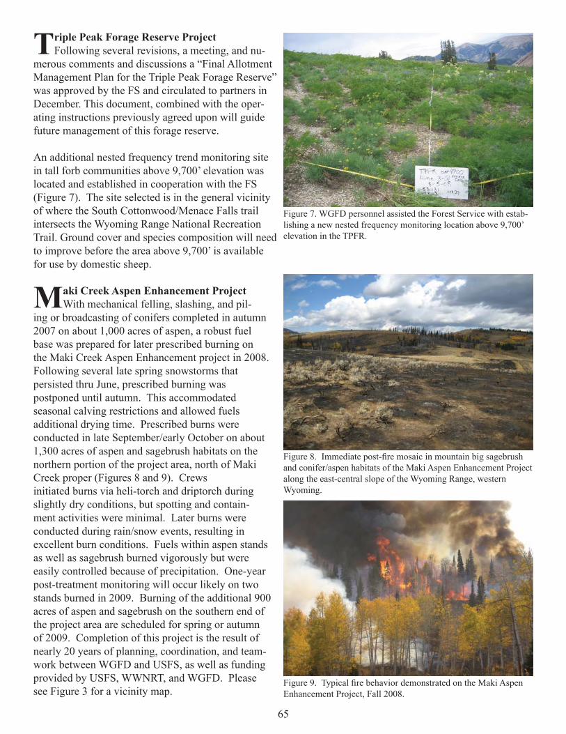
65
Triple Peak Forage Reserve ProjectFollowing several revisions, a meeting, and nu-
merous comments and discussions a “Final Allotment Management Plan for the Triple Peak Forage Reserve” was approved by the FS and circulated to partners in December. This document, combined with the oper-ating instructions previously agreed upon will guide future management of this forage reserve.
An additional nested frequency trend monitoring site in tall forb communities above 9,700’ elevation was located and established in cooperation with the FS (Figure 7). The site selected is in the general vicinity of where the South Cottonwood/Menace Falls trail intersects the Wyoming Range National Recreation Trail. Ground cover and species composition will need to improve before the area above 9,700’ is available for use by domestic sheep.
Maki Creek Aspen Enhancement ProjectWith mechanical felling, slashing, and pil-
ing or broadcasting of conifers completed in autumn 2007 on about 1,000 acres of aspen, a robust fuel base was prepared for later prescribed burning on the Maki Creek Aspen Enhancement project in 2008. Following several late spring snowstorms that persisted thru June, prescribed burning was postponed until autumn. This accommodated seasonal calving restrictions and allowed fuels additional drying time. Prescribed burns were conducted in late September/early October on about 1,300 acres of aspen and sagebrush habitats on the northern portion of the project area, north of Maki Creek proper (Figures 8 and 9). Crews initiated burns via heli-torch and driptorch during slightly dry conditions, but spotting and contain-ment activities were minimal. Later burns were conducted during rain/snow events, resulting in excellent burn conditions. Fuels within aspen stands as well as sagebrush burned vigorously but were easily controlled because of precipitation. One-year post-treatment monitoring will occur likely on two stands burned in 2009. Burning of the additional 900 acres of aspen and sagebrush on the southern end of the project area are scheduled for spring or autumn of 2009. Completion of this project is the result of nearly 20 years of planning, coordination, and team-work between WGFD and USFS, as well as funding provided by USFS, WWNRT, and WGFD. Please see Figure 3 for a vicinity map.
Figure 7. WGFD personnel assisted the Forest Service with estab-lishing a new nested frequency monitoring location above 9,700’ elevation in the TPFR.
Figure 8. Immediate post-fi re mosaic in mountain big sagebrush and conifer/aspen habitats of the Maki Aspen Enhancement Project along the east-central slope of the Wyoming Range, western Wyoming.
Figure 9. Typical fi re behavior demonstrated on the Maki Aspen Enhancement Project, Fall 2008.

66
Cottonwood II Vegetation TreatmentsCottonwood II is a mechanical thinning and
prescribed burn project on the Big Piney RD, immediately following up the Maki Creek Aspen Regeneration Project (Figure 10). This area is important transitional range for mule deer, elk and moose among other species. It is also close toJewett feedground and the project will encourage elk in spring and fall to use native range instead of supplemental feed. In 2008, portions of the target stands were mechanically pre-treated with the remainder of that contract to be completed spring 2009. Burning will follow the mechanical work in these stands in 2009 or 2010. Please see fi gure 3 for a vicinity map.
Monument Ridge Prescribed BurnThe Monument Ridge prescribed burn proj-
ect comprises approximately 11,000 acres of mixed aspen-conifer and sagebrush vegetation types that are in late successional stages on the BTNF in the Bon-durant area (Figure 11). Monument Ridge provides important spring-summer forage and parturition habi-tat for mule deer, antelope, elk, moose, and several other wildlife species. Objectives for burning are to improve the vigor and production of these vegetative communities to maintain healthy wildlife populations.
In 2006, 1,000 acres were treated with prescribed fi re and have been rested from cattle since implementation. Burn mosaic and ground cover monitoring have been completed throughout the 2007 and 2008 fi eld seasons. In 2009, the BTNF anticipates allowing cattle back into the fi rst unit and resting 900 acres in the next unit to the south for a fall 2009 burn.
Wyoming Range Allotment Complex Forage Reserve (WRAC)
Regional personnel assisted the FS with rereading three established nested frequency trend monitoring sites on this Forage Reserve area. To guide future management of the forage reserve the data will be evaluated and trends assessed cooperatively between the FS, regional personnel, and other partners. Forage abundance appeared noticeable greater in the upper South Horse Creek watershed portion of the WRAC than on an adjacent allotment west of the divide.
Figure 10. Conifer encroached aspen stands targeted for treatment in the Cottonwood II Vegetation Treatment.
Figure 11. Map of the Monument Ridge prescribed burn units.

67
Coal Creek Fish Passage ProjectA Cooperative Agreement was developed with TU for the “Coal Creek Fish Passage, Phase I – Design”
trust fund project proposal. This agreement approved $5,000 to assist TU with engineering and design costs for a fi sh screen and new diversion structure on Coal Creek. A design was completed and the new structure is scheduled for installation in the spring of 2009 prior to irrigation season.
Vegetation Differences Among Habitat and Treatment Types in Western Wyoming, Part 1: Fire vs. Mechanical
In summer 2008, Brucellosis-Feedground-Habitat (BFH) and Terrestrial Habitat personnel were assisted by BLM and USGS staff in post- and pre-treatment vegetation monitoring of several sites throughout the east-central slope of the Wyoming Range front, western Wyoming. Previous treatments (prescribed fi re, mechani-cal) occurred from 1993 through 2005 in aspen, sagebrush (Wyoming big, low, mountain big), and mountain mahogany habitats. The goals of this effort were to 1) document and compare vegetation characteristics among habitat and treatment types and 2) assess potential long-term effects of treatments. Ultimately, these results will be compared with results of other treatments (particularly herbicide) from monitoring scheduled in 2009 to help identify possible treatments types most suitable for particular habitat and wildlife needs in the area.
Prior to 1998, data were col-lected by use of nested fre-quency (species compostion and richness), line-point intercept (% basal cover), and point-center-quarter (density and % occurrence of dominant/targeted spe-cies by age/height classes) methods conducted in late July through late August, as well as production clipping conducted from September through October. After 1998, methods included line-point intercept (species composition and richness, % basal ground cover) and shrub/tree belt (density and % occurrence of dominant/targeted species by age/height classes) conducted from mid-June through early July, as well as herbaceous production clipping conducted from mid-August through early September. In all years, data were collected on treatment and paired control plots. Specifi c locations monitored in this study included Gentle Annie Springs, Camp Creek Individual allotment, two sites on Cretaceous Mountain, two sites on Bench Corral, and Ryegrass Individual allotment (Table 1). To assess potential differences in herbaceous production, species richness, shrub density and composition, and basal cover, we averaged all historic and current data from each site. We then compared parameters between paired treatment and control sites, and further compared these among habitat and treatment types.
We found that regardless of habitat or treatment type, production of grasses and forbs were generally greater on treatment than control plots (Figure 12). Fire appeared to have a greater effect than mechanical treatment on grass production in shrub habitats, while production of forbs is enhanced similarly between treatment and among habitat types. Although the mountain big sagebrush mowing treatment showed lower grass and forb production than the control plot, this is likely a result of fewer years of data collection (i.e., smaller sample size) particularly during a period of well below to average spring/summer precipitation.
Table 1. Habitats, treatments, and dates of implementation on sites monitored for vegetation characteristics along the Wyoming Range front, western Wyoming, 2008.

68
Total herbaceous species richness did not appear to be affected by any treatment, but was likely more infl uenced by site potential. With respect to forbs, richness was low to modestly correlated with annual production of grasses (used as a surrogate index for annual precipitation, R2 = 0.12 to 0.40) within treatment and control sites, suggest-ing that annual precipitation rather than treatment enhances recruitment of annuals. Based on data from all years combined, shrub densities were (and continue to remain) reduced substantially in sites treated with fi re, while those treated mechanically were much more similar to control sites (Figure 13). Regardless of treatment type, proportions of shrubs encountered in seed-ling and young categories were typically higher on treated than control sites, whereas untreated sites tended to have greater proportions in mature and decadent shrubs. Basal cover of bare ground and litter was higher and lower, respec-tively, on sites treated with fi re rather than control sites. All basal cover categories were similar between mechanically treated and control sites.
In summary, fi re and mechanical treatments appear to boost grass and, to a lesser extent, forb production in all habitat types, yet fi re has the most long-term impact to shrub densities and age/size composition, as well as associated basal cover. Similar data to be collected in 2009 from fi re and herbicide treated sites should facilitate greater understanding of shrub community vegetation responses to various treatment types throughout the east slope of the Wyoming Range and possibly other locations in Wyoming. Land and wildlife stewards planning future habitat treatments should consider potential vegetation responses within treatment and habitat types, land use of the area, as well as local habitat, wildlife, and possible livestock needs prior to implementing any treatment.
Figure 12. Mean annual production of grasses and forbs from treatment and paired control plots, western Wyoming, 1993-2008.
Figure 13. Mean density of stems from treatment and paired control plots, western Wyo-ming, 1993-2008

69
Pinyon Osborn Prescribed BurnThe Pinyon Osborn prescribed burn project comprises approximately 24,000 acres of mixed aspen-conifer
and sagebrush vegetation types that are in late successional stages. In 2008, the fi re effects crew joined the WGFD to conduct pre-burn monitoring at the Pinyon-Osborn Project, near Green River Lakes north of Pine-dale. This is a very large project, which will be broken into sections for implementation. The fi rst two burn units treated will be the 7,600 acre Roaring Fork Unit, and the 2460 acre Wilderness Unit. The Wilderness unit is located in congressionally designated wilderness, which has never been part of a prescribed burn before on the Bridger-Teton National Forest.
The Wilderness unit includes a very steep and rugged mountainside (Osborn Mountain) featuring dense conifer growth encroaching onto formerly open cliff bands and gullies. Wildlife biologists concerned about bighorn sheep habitat are hoping to remove many of these conifers to improve sight distances for the sheep, which tend to avoid areas with poor visibility.
The Roaring Fork unit includes lower-elevation benches and foothills with sagebrush, aspen, and conifer stands. It is an important area for elk transitional range and cattle grazing. The WGFD has recommended prescribed fi re for this area to attract elk away from the Upper Green River Elk Feedground, where they are crowded together during the peak transmission period for the disease brucellosis. In addition, mixed aspen and conifer stands will be targeted for treatment with fi re.
The Roaring Fork – Wilderness Fire Effects Monitoring Plan includes the following draft objectives:1. Burn Mosaic Mapping to indicate how the treatment helps to meet desired landscape-level seral diversity conditions; 2. Attain at least 85% ground cover in burned sagebrush and 95% ground cover in burned aspen 3 years post treatment; and3. Attain at least 1000 live aspen suckers per acre in burned aspen stands greater than 10 feet tall, 15 years post treatment.
The planned prescribed burn for these units is on hold until 2010. The monitoring objectives may change and additional items may be added prior to implementation. In 2008, pre-burn ground cover measurements were made in sagebrush vegetation. With 29 randomly located transects, bare ground was estimated to be only 6.2 +/- 2.0% (80% confi dence). Aspen ground cover monitoring will be conducted three years post burn in a stand to be designated after the treatment. Given the steep and rugged nature of the Wilderness Unit, photopoints were used to document the pre-burn status of conifer forest (Figure 14). Two locations were established, where post burn pictures will be obtained for comparison.
Several BFH macroplots have also been installed in the Pinyon-Osborn project area over the years. The USFS Fire Effects Crew and WGFD will review the plot data and determine how to proceed. It may be necessary to re-collect some of the pre-burn data collection at some of these plots.
Figure 14. Photopoint showing the sagebrush in the Roaring Fork Unit with the Wilderness Unit in the background

70
Double J Ranch Lawson AeratorProject planning began with this landowner in the
summer of 2007 to implement a 355 acre Lawson Aerator treatment on his property (Figure 15). The Habitat and Access Statewide crew completed project implementation in July 2008. This is a cooperative project with NRCS, who utilized Farm Bill EQIP dollars for implementation. The project goals are to reduce the density of decadent mountain big sagebrush cover and provide a diversity of age classes across this property. Prior to treatment, NRCS and WGFD established pre treatment line intercept data and shrub cover data with the landowner to measure our success. This private property is in important transitional range for mule deer and antelope and is seasonally used by sage grouse. Increasing age class diversity should assist in maintaining productive habitats for these species into the future.
Horse Creek Wildfi reIn 2007, approximately 10,000 acres were burned in
a wildfi re in the Horse Creek and Prospect Mountain areas on the Big Piney Ranger District of the BTNF (Figure 16).During the 2008 fi eld season WGFD and Fire Effects Crew personnel established aspen monitoring in the area that burned. Sucker density and browse utilization were monitored in an area that had an aspen component prior to the fi re. Livestock grazing has been excluded from this burn since the 2007 fi re to assist with aspen response and watershed objectives. We have a unique opportunity to monitor aspen response to this wildfi re compared to the Maki and Cottonwood II mechanical/prescribed burn treatments due to their proximity to one another.
Ranch PlanningDuring 2008, several ranches have begun ranch plans through NRCS, JIO or other cooperative efforts.
These ranch plans are critically important for maintaining wildlife habitat across a landscape of mixed owner-ships. East Fork Livestock, Cottonwood Ranches and High Lonesome Ranch have all engaged in various levels of landscape planning. These plans include goals such as maintaining a fi nancially viable livestock operation, increasing habitat for sage grouse, improving migration corridors for wildlife, and improving condition of rangelands. Many of these landowners are engaged with federal agencies on allotment management as well.
Allotment PlanningDuring 2008, several allotments and permittees have been involved in planning efforts to improve the
function of their federal allotment for both livestock and wildlife goals. On BLM Pinedale Field Offi ce lands, permittees and range staff for North LaBarge Common, Squaretop Common, and Bench Corral Individual allot-ments are all engaged in a process of inventory and/or project planning. Various goals are being discussed such as increasing wildlife habitat for sage grouse and big game, improving migration corridors for wildlife, improv-ing water sources, and improving condition of rangelands. Landscape level planning has resulted in many new concepts and changing traditional management plans to better balance of a variety of objectives.
Figure 15. Photo showing the Lawson Aerator at work on the Double J Ranch treatment in 2008.
Figure 16. Photo showing aspen regeneration one season after the Horse Creek wildfi re in 2007.

71
New Fork Wildfi reIn 2008, approximately 15,000 acres were
burned in the New Fork wildfi re that was placed in a long-term management plan (Figure 17). The fi re was managed at certain strategic locations and directed to avoid certain areas on the west edge of fi re activity adjacent to private property (Figure 18). Otherwise the fi re behaved naturally and created an excellent natural mosaic across many acres of wildlife habitat. This fi re created a mix of age classes across the landscape that will benefi t a wide variety of terrestrial and aquatic species.Watershed benefi ts will be present for many years into the future.
OTHER SIGNIFICANT ACCOMPLISHMENTS
•Wyoming Range Mule Deer Initiative was started and will have a large habitat component to it. The Wyoming Range Mule Deer Habitat Assessment started in 2008 south of LaBarge Creek in the Green River District. This effort is contracted out to the TSS and will assist with improving management of important habitats for the Wyoming Range mule deer herd. •Wyoming Range Interagency Habitat Initiative (WRIHI) worked cooperatively on project implementation and discussions across landownership and management boundaries.•Continued involvement with the Mesa Sagebrush Enhancement Project, which was implemented in 2006 and remains excluded from grazing management for research purposes.•Worked with Regional personnel to develop a mitigation plan for the Cimarex Development that includes $350,000 for habitat enhancement work over the next ten years. •Provided comments on a “Preliminary Proposed RMP and Final EIS” in May and on the “Proposed Resource Management Plan / Final EIS” released for a 30 day protest period in August. The “Cooperator” role on the Kemmerer BLM Resource Management Plan (RMP) has now been fulfi lled.
Figure 18. New Fork Wildfi re location.
Figure 17. New Fork Fire behavior, summer 2008.

72
•Provided extensive comments pertaining to development of SHP prioritization criteria. Seven regional Aquatic Crucial Habitat Areas and two Enhancement Areas were identifi ed and narratives were developed for each. Also, regionally developed lists of “Values” & “Issues” were prepared.•Evaluated the state land parcel bisected by Rock Creek with the grazing lessee and discussed opportunities to improve management including riparian corridor fencing, drift fences, revisions to the BLM’s Rock Creek AMP, and alternative areas to graze.•Commented on Wyoming Water Development Commission’s Level II Study Report for the proposed Sublette Creek Reservoir and Covey/Mau Canal Rehabilitation Project.•Coordinated internal comments and discussion regarding potential Department involvement and support for The Nature Conservancy proposed development of a Conservation Action Plan (CAP) for the Bear River water-shed.•Coordinated with The Conservation Fund regarding the WWNRT proposal and other on-going efforts to secure funding for the Carney Conservation Easement on the upper Green River. Acreage previously owned by two families has been consolidated increasing the total available for CE to 3,750.•Coordinated with various private partners and the NRCS on the East Fork River, Faler Creek, 40 Rod Creek, and Big Twin Creek to review and assist with development of stream enhancement and wildlife friendly fenc-ing projects. Formal comments and a WWNRT support letter were provided. These projects are scheduled for implementation in 2009.•Coordinated with the FS, TU, irrigators, and a consultant regarding the potential need, designs, and cost es-timates for fi sh screens on the Highland and Fremont ditches at Fremont Lake dam on Pine Creek. Additional monitoring should be conducted to assess fi sh loss in these canals and possible alternatives to screening.•Toured with the Sublette County Conservation District (SCCD) to evaluate opportunities and ideas to address sediment run off in the Alkali and Sand Draw watersheds. Written recommendations and suggestions were provided to SCCD.•Evaluated and discussed opportunities to enhance spawning habitats and riparian conditions at the Exxon/Mo-bile Sawmill Creek CRC pond in the Dry Piney Creek watershed.•Assisted FMPE with WHAM surveys in Sjhoberg and Nylander Creek watersheds. An administrative report summarizing these and other WHAM surveys and fi sh population / distribution evaluations throughout the For-est Service portions of the South and North Cottonwood watersheds has been drafted by FMPE and reviewed by the PE-AHAB.•Coordinated a meeting between Department personnel and owners of the High Lonesome Ranch on South Cottonwood Creek. Opportunities to meet mutual wildlife/fi sheries goals and objectives were discussed, includ-ing JIO baseline vegetation inventories, sage grouse habitat/use inventories, fi sh population and riparian habitat assessments, weed control, and fence modifi cation.

73
SHERIDAN REGION
HABITAT PROJECTS
Kendrick and Interstate Dams Fish PassageKendrick Dam is a barrier to fi sh passage on lower Clear Creek. It blocks eight fi sh
species endemic to lower Clear Creek and the Powder River from accessing the middle seg-ment of Clear Creek (Figure 1). These species, which include sauger, channel catfi sh, shov-elnose sturgeon, goldeye, river carpsucker, sturgeon chub, and plains and western silvery minnow, generally inhabit cool to warm water in mid to large-size, turbid streams. Estab-lishing fi sh passage past the dam would restore access to at least 36 miles of Clear Creek suitable for the cool/warm-water aquatic species assemblage endemic to the Powder River.
A written agreement was reached with the PeeGee Ranch to develop, maintain, and operate a fi sh bypass channel around Kendrick Dam. Cost-share funding to implement the bypass channel project was pursued in anticipation the ranch will consent to implement the fi nal plans. WWC Engineering was contracted to complete fi nal design engineering of the bypass channel. Final designs are expected by summer 2009. The ranch must approve the fi nal design plans upon the completion of design engineering.
The Interstate Diversion at the Welch Ranch property limits or completely blocks migratory sauger and channel catfi sh from reaching up to 26 miles of the Tongue River and 12 miles of Goose Creek. Establishing dependable fi sh passage at the dam would make suitable habi-tats available for these species in segments of both streams.
• Enrolled 94,989 acres to enhance sagebrush com-munities for sage-grouse.
• Aerated 3,770 acres to restore rangelands and enhance sage-grouse brood-rearing habitats.
• Rejuvenated 150 acres of wooded draws.
• Treated a 767 acre sagebrush community by burning patches within the com-munity equaling approximately100 acres.
• Prepared a re-source manage-ment plan for the 3,960 acre Wyoming Army National Guard Sheridan Local Training Area.
• Ten beaver were transplanted to the Beaver Dam Creek on the Black Hills Na-tional Forest.
• Inventories or monitoring assessmentscompleted on 36 miles of stream.
Figure 1. At least 36 miles of Clear Creek, to the Platt and Ferris #3 Diversion could be made available to eight native fi sh species currently confi ned below Kendrick Dam.

74
Representatives from the Interstate Ditch Company, which operates the Interstate Diversion, and PeeGee Ranch, which operates the Kendrick Diversion on Clear Creek, participated in a tour of the newly completed upstream fi sh bypass channel at the T & Y Diversion Dam on the Tongue River near Miles City, Montana (Figure 2). The tour provided an opportunity to view a real world example of a bypass channel of the same design being considered for implementation at the Interstate Diversion and Kendrick dams.
Lake Desmet Conservation District’s Sagebrush/Grassland Habitat Restoration Program (PhaseIV)- Progress Report
This program just completed it’s forth year of enrolling ranches to enhance sagebrush and grassland communi-ties. Its foundation is to emulate the Deseret Land & Livestock management model to achieve enhanced bene-fi ts for livestock and wildlife. The paper “Sage Grouse Ecology and Management in Northern Utah Sagebrush-Steppe, a Deseret Land and Livestock Wildlife Research Report, 2002” by R. E. Danvir provides documentation of benefi ts to sage-grouse from their ranch management operations. Deseret experienced a six-fold increase in male lek attendance by implementing timed livestock grazing, forb plantings and mechanical treatments. Their ranch management operations also benefi ted mule deer, pronghorn antelope and other wildlife. Due to Deser-et’s success at increasing wildlife populations while supporting a working ranch, the Lake DeSmet Conservation District (LDCD) in partnership with private landowners and NRCS initiated this program to replicate and test this “win-win” management model on private and public lands in northern Johnson County.
Since then, the LDCD has partnered with numerous agencies, non-governmentalorganizations, founda-tions and industry to restore the productivity of sagebrush/grassland communities in northern Johnson County. This community-based pro-gram has had tremen-dous success. So far, over $3.3 million have been granted to restore 353,722 acres. Phase IV of the program enrolled an additional 94,989 acres in 2008 (Figure 3).
Figure 2. The T&Y Diversion bypass channel on the Tongue River south of Miles City, MT is the same design as proposed for the Tongue River and Clear Creek (MTFWP photo).
Figure 3. The LDCD (northern Johnson County) has enrolled 24 livestock producers, consisting of 353,722 acres, to restore and enhance sagebrush/grassland communities. This program has grown to a scale where it could potentially benefi t wildlife populations on a landscape level. In addition, 10,801 acres have been treated with an aerator and planted with an assortment of forbs and shrubs.

75
The NRCS and contractors have, and are, preparing ranch management plans for 24 livestock producers. These plans include rangeland resource inventories, conservation strategies, infrastructure needs, livestock grazing practices and monitoring techniques for measuring management changes. The WGFD prepares reports showing sage-grouse seasonal distribution maps and suggested livestock grazing best management practices per pas-ture. This year, only one of these reports was prepared. Six more are needed by early 2009, however. Dr. Roy Roath, a rangeland and livestock grazing specialist from Colorado State University and others are contracted to educate livestock producers and assist them with developing progressive plans that will benefi t both livestock and wildlife. All resource information is managed in a geographic information system database to supply a rapid decision-making tool for land managers.
Funding partners, in order of contributions, include the Wyoming NRCS, private landowners enrolled in the program, National NRCS, WWNRT, Wyoming Governor’s Sage-Grouse Fund/NE Wyo. Sage-Grouse Local Working Group, WGFD, oil and gas industry (Anadarko Petroleum, Lance Oil and Gas, Kennedy Oil), BLM, LDCD, USFWS, DEQ SEP, Sheridan/Johnson County Chapter of Pheasants Forever, WGBGLC, Eyas Founda-tion, Wyoming Private Lands Grazing Team, Bighorn Environmental Consultants, WFW Foundation and Bow Hunters of Wyoming.
Approximately 10,801 acres (3,770 acres in 2008) have been treated with aera-tion equipment to restore rangelands and enhance sage-grouse brood-rearing habi-tats (Figure 4). By improving herbaceous production and maintaining conservative livestock stocking rates, we expect to reserve more forage and cover for wild-life. The aerator is also used to enhance overfl ow and riparian sites for sage-grouse brood rearing. Seed is also planted during most aeration operations. Species selected depend on soil conditions and include prairie conefl ower, American vetch, white prairie clover, Spreador alfalfa, winterfat, fourwing saltbush and yarrow.
Other accomplishments included:• Preparing a packet of instructions and maps so participating landowners could help monitor their sage-
grouse leks. Seven GPS units were purchased by the LDCD for enrolled landowners to document grouse locations.
• Working with researchers to develop habitat requirement guidelines for sage-grouse in NE Wyoming, where they tend to tolerate less sagebrush.
• Collaborating with the NRCS and LDCD to initiate research to test NRCS transition models, soil types and Ecological Site Descriptions as predictors of sage-grouse nesting habitat. A grant proposal was prepared and ultimately funded by the Northeast Wyoming Sage-Grouse Local Working Group using the Governor’s sage-grouse funds. The research will begin in 2009. Dr. Kevin Doherty, Senior ecologist for Audubon-
Wyoming will perform the analysis. • Renovating the WGFD’s Lawson Pasture Aerator. Over the last three years it has treated approximately
7,000 acres, thus requiring a major overhaul, including replacement of the third set of teeth, new tires, hy-draulic ram rebuilds and numerous welds and structural improvements. Approximately 10,000 more acres are contracted for aeration.
• Working with the LDCD, NRCS and select ranchers to provide tours and project reviews for WGFD staff and the WWNRT board.
Figure 4. An aerator implement with mounted seed boxes was used to im-prove the productivity of go-back (previously farmed) lands. By increasing forage production in pastures where sagebrush is not a signifi cant compo-nent, the livestock producer has the fl exibility of developing a livestock-grazing system for the entire ranch that’s more sage-grouse friendly.

76
Lake DeSmet Conservation District Diversion RehabilitationThe Russell Diversion on Rock Creek (Figure 5) and the Big Bonanza Diversion on Clear Creek
(Figure 6) were rehabilitated during 2008 through the on-going irrigation diversion rehabilitation and fi sh passage program administered by the Lake DeSmet Conservation District. The Department served as a funding partner and provided design guidance to the program. The purpose of the projects was to improve channel stability and function at the diversions, and establish or improve upstream fi sh passage past the diversion structures. Several game and numerous nongame fi sh benefi t from the projects.
Rehabilitation at the Watt Diversion on Clear Creek (Figure 7) was initiated in 2008, though additional pipeline work will be necessary in 2009. Screening to exclude fi sh from the diversion ditch was an additional objec-tive at the Watt Diversion rehabilitation project. A Coanda screen, including a water collection vault and outlet pipeline, was built at the crest of a cross vane in-stream structure. The innovative design is unproven, however. Therefore, monitoring will be necessary to assess the function and maintenance needs of the screen.
Figure 5. Rehabilitating the Russell diversion on Rock Creek reconnected 3.2 miles of stream below the diversion with 1.1 miles of stream above the diversion. The work included devel-oping stepped cross vane structures, and a bankfull bench along the left bank above the diversion.
Figure 6. Rehabilitating the Big Bonanza Diversion on Clear Creek reconnected 16.4 miles of stream below the diversion to 3.1 miles of stream above the diversion.Work included vane structures and a rock ramp.
Figure 7. A Coanda Screen, which is shown being placed, will occur at the crest of a cross vane structure (not shown) at the Watt Diversion. Work at the diversion reconnected 3.1 miles of Clear Creek between the Big Bonanza and Watt diversions to 3.7 miles of stream above the Watt Diversion.

77
The Lake DeSmet Conservation District was granted additional cost-share assistance to maintain instream struc-tures at the Clear Creek Land and Ditch (Rule) irrigation diversion. The structures were constructed during the fi rst phase of the diversion rehabilitation and fi sh passage program. Some rocks in the structures shifted during fl ooding conditions and altered the function of the diversion. In fall, fi sh – predominately trout – were salvaged from the diversion ditch and returned to Clear Creek. Options to screen the diversion ditch are being explored by NRCS.
Wooded Draw Restoration in Sheridan County-Progress ReportTNC, WGFD, RMEF and WGBGLC are collaborating on a program that is designed to help landowners
restore impoverished wooded draw habitats. Funds are still available for landowners along the east slope of the Big Horn Mountains.
Wooded draws provide key habitat for nearly all wildlife species living in the Northern Great Plains. For white-tailed and mule deer, these draws provide fawning habitat, escape cover and browse. Studies indicate that deer spend over half their time in this habitat type. Wooded draws are also important to wild turkey, sharp-tailed grouse, pheasants and numerous other birds and mammals. These plant communities consist of native plum, chokecherry, service-berry, aspen, hawthorn, Woods’ rose and others. Most communities appear to be nearing the end of their life span and need fi re to rejuvenate them (Figure 8).
Approximately 150 acres of wooded draws were burned this year on one ranch. Another ranch is signing up and scheduled for a burn this spring (2009). For qualifying ranches, the WGFD, RMEF and WGBGLC will fund 100 percent of the costs associated with the burn. In return, the rancher must defer grazing and control weeds and white-tailed deer populations.We ultimately hope to revert succession on approximately 2,000 acres of wooded draws and associated uplands.
Mule Deer and White-Tailed deer habitat suitability index model development Mule deer and white-tailed deer habitat suitability models (HSI) were developed, which are based on re-
search publications and expert opinion within the WGFD Sheridan Region. The mule deer model (Figure 9) has three variables: 1) terrain texture diversity, 2) landcover/habitat diversity and 3) proximity to green herbaceous vegetation (hay fi elds, seeps, riparian habitats, etc.). The white-tailed deer model also has three variables that predict the quality of habitats. Other than terrain, we measured the proximity to deciduous woody cover and green herbaceous vegetation.
Regional biologists and game wardens reviewed the resulting HSI maps and made recommendations for im-provements. Alterations will be made in 2009. The resulting electronic maps will allow biologists to quantify habitats and assess anthropogenic effects on deer populations, such as coal-bed natural gas development and housing developments. We will also use the data to focus limited resources on the very best mule deer habitats in the region.
Figure 8. Previous wooded draw burns have responded well to treat-ments. This burn was conducted in 2004 and shows an abundance of new sprouts.
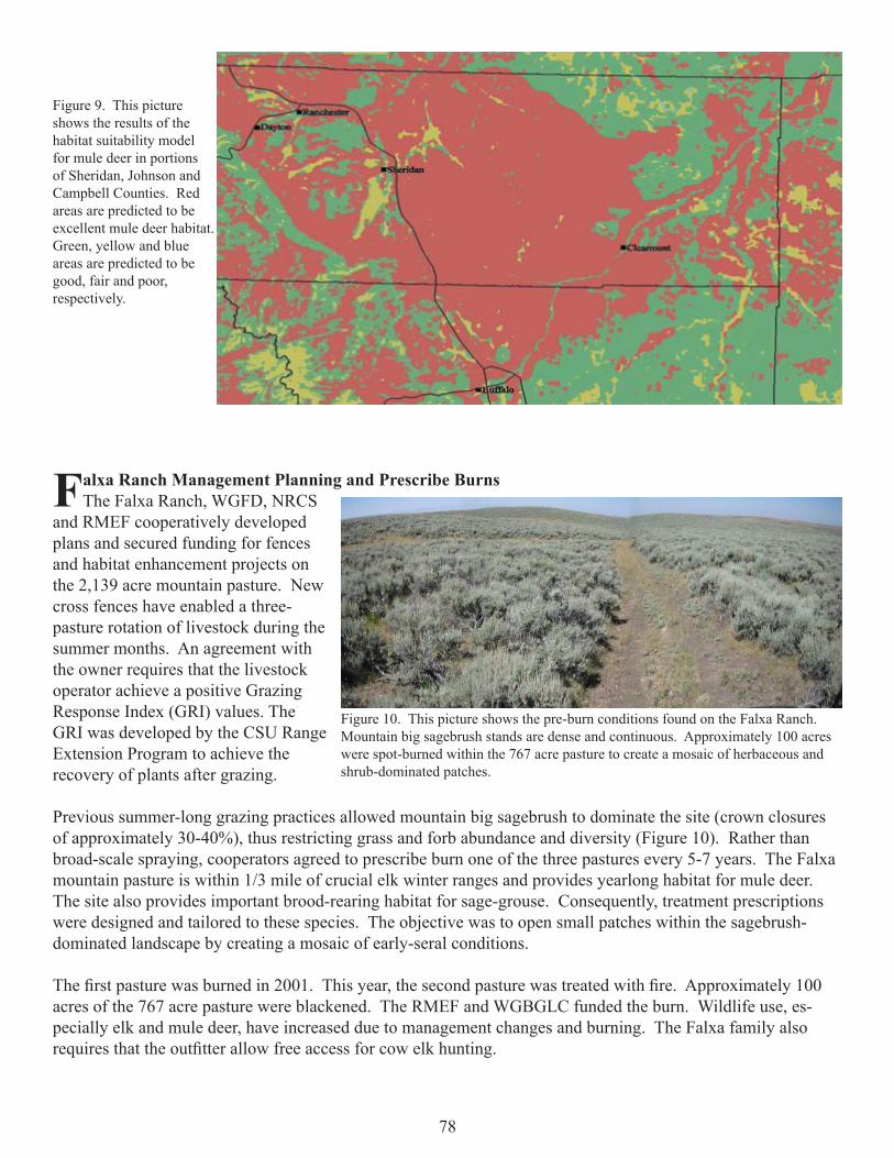
78
Falxa Ranch Management Planning and Prescribe Burns The Falxa Ranch, WGFD, NRCS
and RMEF cooperatively developed plans and secured funding for fences and habitat enhancement projects on the 2,139 acre mountain pasture. New cross fences have enabled a three-pasture rotation of livestock during the summer months. An agreement with the owner requires that the livestock operator achieve a positive Grazing Response Index (GRI) values. The GRI was developed by the CSU Range Extension Program to achieve the recovery of plants after grazing.
Previous summer-long grazing practices allowed mountain big sagebrush to dominate the site (crown closures of approximately 30-40%), thus restricting grass and forb abundance and diversity (Figure 10). Rather than broad-scale spraying, cooperators agreed to prescribe burn one of the three pastures every 5-7 years. The Falxa mountain pasture is within 1/3 mile of crucial elk winter ranges and provides yearlong habitat for mule deer. The site also provides important brood-rearing habitat for sage-grouse. Consequently, treatment prescriptions were designed and tailored to these species. The objective was to open small patches within the sagebrush-dominated landscape by creating a mosaic of early-seral conditions.
The fi rst pasture was burned in 2001. This year, the second pasture was treated with fi re. Approximately 100 acres of the 767 acre pasture were blackened. The RMEF and WGBGLC funded the burn. Wildlife use, es-pecially elk and mule deer, have increased due to management changes and burning. The Falxa family also requires that the outfi tter allow free access for cow elk hunting.
Figure 10. This picture shows the pre-burn conditions found on the Falxa Ranch. Mountain big sagebrush stands are dense and continuous. Approximately 100 acres were spot-burned within the 767 acre pasture to create a mosaic of herbaceous and shrub-dominated patches.
Figure 9. This picture shows the results of the habitat suitability model for mule deer in portions of Sheridan, Johnson and Campbell Counties. Red areas are predicted to be excellent mule deer habitat. Green, yellow and blue areas are predicted to be good, fair and poor, respectively.

79
Army National Guard Sheridan Local Training Area- Progress ReportThe 3,960 acre Wyoming Army National Guard’s (WyARNG) Sheridan Local Training Area (LTA) is the
location of one of the WGFD’s HMA. This area has become very popular with local hunters and wildlife enthu-siasts. Improved habitat conditions this year produced and held more wildlife, resulting in better hunter success and satisfaction (Figure 11). Wildlife related recreation opportunities in northeast Wyoming are very limited for residents and they value any opportunity to pursue their sport and activities. The WyARNG administrates the HMA program in an effi cient and friendly manner and provides an important service to local residents.
Natural resources on the LTA, however, need attention and a guiding plan that guarantees the restoration of the area. For the fi rst time in years, livestock graz-ing was not permitted, allowing damaged rangelands and riparian habitats to partially recover from years of inappropriate livestock grazing.
WGFD personnel gathered resource information this year and developed a plan that could be presented to the WyARNG. We hope to offer our assistance with resource management. The WGFD Sheridan offi ce has a team of habitat and wildlife biologists, access specialists, habitat/access maintenance experts and law enforcement personnel who can provide local oversight and management. They have managed WGFD properties for many years and have training in rangeland and riparian habitat enhancement/restoration, resource monitoring, livestock grazing strategies, noxious weed control, access compliance and infrastructure maintenance.
A collaborative effort between local agencies could provide the local oversight that is needed to assure the con-tinued recovery of LTA lands, especially when livestock grazing is reapplied as a management tool. A coopera-tive effort between the WyARNG, WGFD, Wyoming State Lands and Investment Offi ce and Sheridan County could consolidate a block of public lands comprising over 8,500 acres. With support from the NRCS, Sheri-dan County Weed and Pest District, Sheridan County CD and local conservation groups, the LTA and adjacent public lands could be used to improve the ecological condition of all lands, while providing signifi cant public access for the community. This could be achieved without restricting the WyARNG’s ability to conduct training operations.
Sheridan County Conservation District Diversion Rehabilitation A project on South Piney Creek (Figure 12) was completed through an irrigation diversion rehabilitation
and fi sh passage block grant program with the Sheridan County CD. The NRCS designed the rehabilitation project. The purpose was to restore fi sh movements past the diversion dam, limit fi sh entry into the diversion, enhance the stability of the stream channel at the diversion site, and reduce operational and maintenance needs of the diversion operators. The Department served as a funding partner, which was possible through a block grant with the conservation district, and provided design guidance to the program. Additional projects on the Tongue River and Big Goose Creek are currently being designed and are anticipated in 2009.
Figure 11. Above average precipitation and a long history of heavy livestock grazing resulted in vigorous stands of yellow sweetclover and annual brome grasses on the LTA this year. With no livestock grazing, range plants had the full growing season to recover.
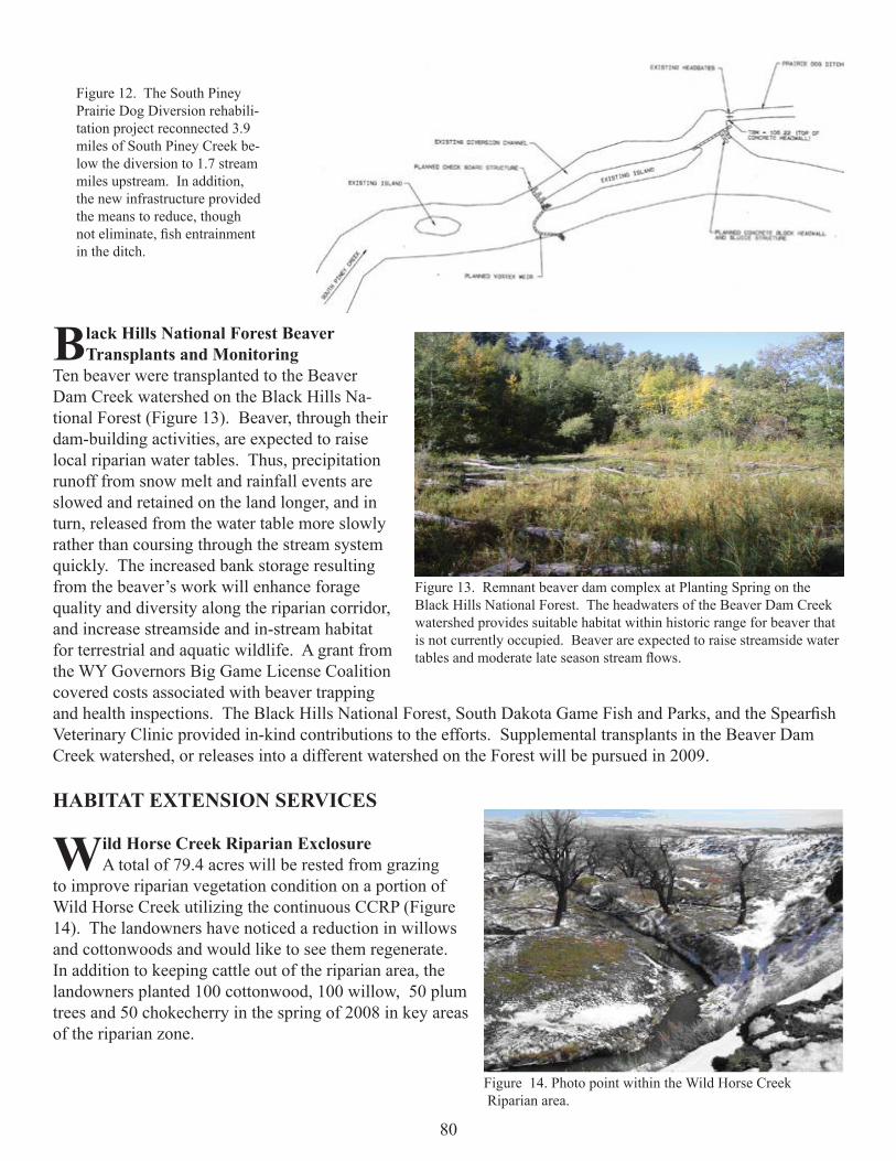
80
Black Hills National Forest Beaver Transplants and Monitoring
Ten beaver were transplanted to the Beaver Dam Creek watershed on the Black Hills Na-tional Forest (Figure 13). Beaver, through their dam-building activities, are expected to raise local riparian water tables. Thus, precipitation runoff from snow melt and rainfall events are slowed and retained on the land longer, and in turn, released from the water table more slowly rather than coursing through the stream system quickly. The increased bank storage resulting from the beaver’s work will enhance forage quality and diversity along the riparian corridor, and increase streamside and in-stream habitat for terrestrial and aquatic wildlife. A grant from the WY Governors Big Game License Coalition covered costs associated with beaver trapping and health inspections. The Black Hills National Forest, South Dakota Game Fish and Parks, and the Spearfi sh Veterinary Clinic provided in-kind contributions to the efforts. Supplemental transplants in the Beaver Dam Creek watershed, or releases into a different watershed on the Forest will be pursued in 2009.
HABITAT EXTENSION SERVICES
Wild Horse Creek Riparian ExclosureA total of 79.4 acres will be rested from grazing
to improve riparian vegetation condition on a portion of Wild Horse Creek utilizing the continuous CCRP (Figure 14). The landowners have noticed a reduction in willows and cottonwoods and would like to see them regenerate.In addition to keeping cattle out of the riparian area, the landowners planted 100 cottonwood, 100 willow, 50 plum trees and 50 chokecherry in the spring of 2008 in key areas of the riparian zone.
Figure 12. The South Piney Prairie Dog Diversion rehabili-tation project reconnected 3.9 miles of South Piney Creek be-low the diversion to 1.7 stream miles upstream. In addition, the new infrastructure provided the means to reduce, though not eliminate, fi sh entrainment in the ditch.
Figure 13. Remnant beaver dam complex at Planting Spring on the Black Hills National Forest. The headwaters of the Beaver Dam Creek watershed provides suitable habitat within historic range for beaver that is not currently occupied. Beaver are expected to raise streamside water tables and moderate late season stream fl ows.
Figure 14. Photo point within the Wild Horse Creek Riparian area.

81
Mule Deer Legume Seeding ProgramFunding from the WGFD Trust Fund was made
available to each region to reimburse interested landown-ers for legume seedings that would benefi t mule deer, and other wildlife species (Figure 15). Various sites within Weston and Campbell County were visited to assess whether legume plantings would benefi t mule deer.
Interested landowners were required to sign an 8 year contract stating that they would allow public harvest of does to assist in keeping populations at more ideal levels and allow for regrowth of critical shrubs. To date, four landowners have signed up to seed a total of 200 acres to alfalfa and will allow public harvest of does.
WILDLIFE HABITAT MANAGEMENT AREAS
Sand Creek Public Fishing Area ManagementThe Aquatic Habitat Biologist coordinated plans with the grazing lessee for livestock turn-in on the Sand
Creek Access Area. Three hundred twenty four head or pairs were grazed on the Sand Creek public access area from May 27 to June 6. Some stragglers remained until June 8. Using a direct one pair per animal unit conver-sion, actual use equated to about 119 animal unit months.
OTHER SIGNIFICANT ACCOMPLISHMENTS
•Assisted personnel conducting prairie stream surveys in eastern Wyoming to establish and implement riparian vegetation monitoring.•Monitoring was completed at three sites along the stream rehabilitation project in Buffalo to assess fl ood ef-fects on in-channel habitat conditions. The bed-load moving episode associated with the fl ood fl ows aggraded some of the rehabilitation work. In addition, temperature assessments were initiated to assess if deep pools provided thermal refuges for fi sh during low fl ow conditions. Additional temperature assessments are planned next year.•WGFD and the WWNRTB provided cost-share assistance to the Bighorn National Forest to complete the rock haul phase of the South Tongue River Boy Scout Reach Stream Rehabilitation project. Implementation is anticipated in summer 2009.•The third and fi nal year of fi eldwork was completed for a cooperative study with the Bureau of Reclamation and NRCS. The project involved capturing, tagging, and monitoring tagged fi sh movements above and below a stepped cross-vane diversion structure on Clear Creek. Monitoring to determine if tagged fi sh were passing the structure included mark and recapture techniques and automated fi sh detection at passive inductor tag antenna stations. The ultimate goal was to improve design guidance for rehabilitating structures to provide passage of prairie stream associated fi shes. A comprehensive report on the project is in process.•Baseline morphology assessments were completed at an upper inventory site on Crazy Woman Creek. The intent was to assess current conditions and facilitate future monitoring. Final analyses of all Powder River and Crazy Woman Creek morphology assessments are in process.•Concept design recommendations were provided to the WYDOT to establish fi sh passage at the I-25 barrier on Clear Creek. WYDOT subsequently postponed further planning, because the accompanying Interstate resurfac-ing project was postponed.•Inventory was initiated in the headwaters of the Little Tongue River watershed above its confl uence with the South Fork of the Little Tongue. The watershed segment has about 16 miles of perennial and 18 miles of inter-mittent streams. The intent is to identify opportunities to improve habitat management for Yellowstone Cut-throat trout. Additional inventory will occur in 2009.
Figure 15. Antelope in Campbell county utilizing Sagebrush

82
• Provided technical assistance or information on the management or restoration of aquatic or riparian habitats to 18 additional landowners, managers, consultants, or NRCS representatives serving a landowner. One of the contacts involved a request for cost-share assistance that was handled through the PLPW program, and half (9) the contacts involved projects being funded by other groups.• Assisted water management personnel assess fl ow, velocity, and temperature on Big Goose Creek.• Monitoring of channel bed elevations was established below a newly constructed low water crossing on the Powder River. The objective was to assure the hardened crossing does not become a passage barrier.• Assisted with Don Spellman Ranch rotational grazing plan. • Assisted NRCS with creating maps for development, primarily for EQIP projects.•Assisted BelAyr mine with NRCS Plant materials center experimental seeding.• Habitat personnel collected resource information on the highest priority “access” tract and identifi ed resource issues that need addressed. A meeting was arranged with the NRCS and Sheridan County CD to discuss a collaborative effort to provide technical and fi nancial assistance to the lessee. The goal is to provide the in-frastructure and plans necessary for implementing a state-of-the-art livestock grazing system. Improving the condition of rangelands and associated wooded draws and riparian habitats is expected to benefi t white-tailed and mule deer, sharp-tailed grouse, Hungarian partridge, pheasants and numerous other birds and mammals. We are presently negotiating with the lessee.
• Publications- The WGFD report titled Response of Prairie Stream Riparian Buffers to Livestock Exclusion and Short-Duration Grazing in Northeast Wyoming-A Pre- and Post- Photographic Comparison has gained national attention. In addition to the WGFD web page, it’s now posted and referenced on Wyoming and Montana Natu-ral Resources Conservation Service and Holistic Management International sites.
• Mapping Sage-Grouse Habitats- WGFD personnel participated on a committee of sage-grouse and remote sensing experts to develop protocol for mapping habitats and modeling potential sage-grouse occurrence in the state. This assignment originated from the Governor’s Sage-Grouse Implementation Team. WGFD person-nel attended University of Wyoming’s sagebrush mapping meeting for volunteers. In addition, time was spent researching and helping with the development of sage-grouse habitat mapping protocol for the Powder River Basin. Several meetings and conference calls were participated in.
• WGFD SHP Revision- Habitat plans prepared by other groups were reviewed to help revise the SHP and considerable time was spent revising the plan for the Sheridan Region. In addition, we examined Sheridan County’s strategy of protecting lands adjacent to the Bighorn National Forest. They proposed limiting devel-opment above 4,600 feet in elevation. It appears that this zone would protect most crucial elk winter ranges in the county.
• USFS Tongue Allotment Management Plan- WGFD personnel were asked to meet with and provide information to the Wyoming Wildlife Foundation (WWF), an important constituent-based conservation group for the agency. WWF was investigating developments that would delay or overturn the implementation of the Bighorn National Forest’s Tongue Allot-ment Management Plan decision. The Record of Decision (ROD) proposed reducing permit-ted livestock grazing by 48 percent.
• WGFD personnel are concerned about retain-ing quaking aspen and willow resources within these allotments, which contain valuable elk and mule deer habitats and a Blue Ribbon trout fi shery (Figure 16). WGFD personnel attended a WWF-sponsored tour of pastures involved in the ROD. Thirty-two agency and conser-
Figure 16. Conditions shown in this picture are typical for quaking aspen communities found on the east slope of the Bighorn National Forest. Old growth aspen clones continue to produce suckers in an attempt to regener-ate the stand. Regeneration rarely occurs, however, because long-term excessive browsing by wild and domestic ungulates keeps new suckers suppressed. Consequently, the more desired multi-layered stands rarely occur.

83
vation group representatives attended. The group viewed examples of resource issues that had been identifi ed by the Forest Service and WGFD. They questioned why the condition of aspen and willow communities had im-proved where livestock had been voluntarily reduced and not in status quo pastures.
• Extension Service Work- Nineteen landown-ers and two consultants were assisted with wildlife habitat enhancement efforts, funding and management strategies to benefi t wildlife. One project on Soldier Creek might result in a new riparian buffer contract under Farm Service Agency’s CRP.
• Eagle Creek Prescribed Fire: The BLM plans to conduct broadcast burns in the fall of 2008 and spring or fall of 2009, in southwest Johnson County. The project is located about 20 miles west of Kaycee, Wyoming. This September, BLM burned the Carpenter Creek portion of the 6,000 acre Eagle Creek proj-ect area, which targeted about 400 acres of shrub and mixed conifer vegetation (Figure 17). Cooperators included the BLM, Johnson County Powder River Fire District, Hole in the Wall Ranch, RMEF; and WGFD. Other prescribed burns planned for 2009 will utilize low intensity fi re to reduce surface fuel load-ing under stands of ponderosa pine.
• WAFWA Mule Deer Habitat Guidelines- WGFD Habitat Section personnel coauthored the Energy and Mineral Development Chap-ter of the Western Association of Fish and Wildlife Agency’s Mule Deer Habitat Guide-lines for the Great Plains Ecosystem. Final edits were made to the document after a peer review process.
• Photo Monitoring- WGFD and BLM personnel photo-monitored previous years prescribed burns (Figures 18 and 19).
Figure 17. The objective of the Eagle Creek burn was to reduce hazard-ous wild-land fuels resulting from disease killed limber pine and improve habitat and forage conditions for big game animals.
Figure 18. WHMA is located near Kaycee, Wyoming. This picture was taken in 1999, on the Ed O. Taylor WHMA.
Figure 19. This photo re-take occurred this summer. Wildfi res in 2006 burned over a three-year-old prescribe-burn and killed new mountain big sagebrush seedlings. These seedlings were too young to produce new seed. With a depleted seed source, it appears that sagebrush reestablish-ment will be very slow. Herbaceous production, however, has substantially increased.