2007 SCEC Annual Report Defining the geometry ...
7
2007 SCEC Annual Report Defining the geometry, segmentation, and slip rate of the Compton blind-thrust fault, Los Angeles Basin, California, for regional earthquake hazards assessment Principle Investigators: James F. Dolan (University of Southern California) John H. Shaw (Harvard University) Participating Graduate Students: Lorraine A. Leon (University of Southern California) Nathan Benesh (Harvard University) Judith Hubbard (Harvard University) SCEC Summer Intern: Stephanie Tsang (University of California – Los Angeles) Participating Undergraduate Students: Jason Munster (Harvard University) In Collaboration With: Dr. Thomas L. Pratt (U.S. Geological Survey – Seattle) Dr. Cathy Snelson (New Mexico Tech)
Transcript of 2007 SCEC Annual Report Defining the geometry ...

2007 SCEC Annual Report
Defining the geometry, segmentation, and slip rate of the Compton blind-thrust fault,
Los Angeles Basin, California, for regional earthquake hazards assessment
Principle Investigators: James F. Dolan (University of Southern California)
John H. Shaw (Harvard University)
Participating Graduate Students: Lorraine A. Leon (University of Southern California)
Nathan Benesh (Harvard University) Judith Hubbard (Harvard University)
SCEC Summer Intern:
Stephanie Tsang (University of California – Los Angeles)
Participating Undergraduate Students: Jason Munster (Harvard University)
In Collaboration With:
Dr. Thomas L. Pratt (U.S. Geological Survey – Seattle) Dr. Cathy Snelson (New Mexico Tech)

Introduction and Rationale The Compton thrust fault is a large blind thrust fault that underlies much of the western part of the Los Angeles metropolitan region (figure 1). It was originally identified by Shaw and Suppe (1996), using industry seismic reflection profiles and well data. The seismic data define a growth fault-bend fold associated with the base of the thrust ramp, which extends northwest-southeast for 40 km along the western edge of the Los Angeles basin (Fig. 1). Based on the fold shape, the fault appears to consist of two geometric segments: one that extends northwest from the Los Angeles River to Protrero gap, near the Baldwin Hills, and the second that extends southeast from just east of the Los Angeles River to Los Alamitos, in northern Orange County. Based on the geometry of the growth fold, Shaw and Suppe (1996) proposed two possible geometries for the underlying fault, both including a fault ramp that dips to the northeast at 15-40°. Shallow splays of this fault have been imaged in 3D seismic data from the Wilmington oil field (Shaw et al., 1999). One of these structural solutions implies that the ramp merges at depth with a detachment system that extends to the northeast beneath the central basin, whereas the alternative solution implies that structure is underlain by a southwest-dipping
Figure 1. Perspective view of the Compton blind-thrust ramp and various segments of the Puente Hills blind-thrust fault beneath Los Angeles. We acquired high-resolution seismic reflection profiles in June 2005 and borehole excavations in June and July 2006 at our study site along the back-limb active axial surface associated with the base of the thrust ramp. Five boreholes were excavated at the 2007 study site in June 2007 and a high-resolution seismic reflection profile in October 2007. Fault surfaces are provided from the SCEC CFM (version 2.0) (Plesch et al., 2004)

fault, forming an active structural wedge. Seismic reflection and well data reveal compelling evidence for Pliocene and Pleistocene activity (Shaw and Suppe,1996). Specifically, these data demonstrate that the fault has generated >500 m of uplift at the base of the Quaternary across the 1- to 2-km-wide fold limb associated with the base of the fault ramp. Based on this structure, Shaw and Suppe (1996) determined a long-term average slip rate for the fault of 1.4 ± 0.4 mm/yr. Despite the fact that this is one of largest and potentially most dangerous earthquake faults in metropolitan Los Angeles, the Compton thrust was recently deleted as an earthquake source from the CGS fault database on the basis of earlier SCEC-funded research (Mueller, 1998). During Summer 2006, we used SCEC funds to excavate a transect of 10 boreholes across the locus of folding above the back limb of the Compton ramp at a site along the northern segment of the Compton Thrust (Fig. 1). These borehole data reveal compelling evidence that the Compton fault is active, in the form of a number of buried fold scarps that lie directly above the updip projection of the axis of active folding observed on the industry seismic reflection data (Leon et al., in prep.). Moreover, analysis of the deformed, shallow growth strata reveals evidence for at least six stratigraphically discrete uplift events, which we interpret as having occurred during several large-magnitude (M >7) earthquakes on the Compton fault. Twenty-five 14C ages from abundant organic-rich clay deposits and from charcoal fragments allow to constrain the ages of these events at 0.85-1.65 ka, 1.65-3.2 ka, 3.2-7.1 ka, 5.5-8.3 ka, 9.1-12.2 ka, and 9.9-13.7 ka. Total uplift of a 14 ka stratum is 8 m, yielding a minimum slip rate for the fault of 1.2+0.5/-0.3 mm/yr (conservatively assuming no folding outside the growth triangle and a fault dip of 28°±3°). The depth of the shallowest buried fold scarp (1 m) attests to the recency of the youngest large magnitude earthquake on the Compton blind-thrust fault. These observations clearly indicate that the Compton fault is active and capable of producing damaging, large-magnitude earthquakes directly beneath metropolitan Los Angeles. Inspired by these results, and in order to investigate the system-level behavior of the fault, we were funded by SCEC in 2007 to begin developing a paleoseismologic and slip-rate site along the southern segment of the Compton Thrust (Fig. 1). During 2007 we were funded to acquire high resolution seismic reflection data and a preliminary set of boreholes to constrain the late Pleistocene to Holocene slip rate, ages and displacements in paleo-earthquakes, and subsurface geometry of the Compton thrust through a multi-disciplinary study of folding above this blind thrust system.
2007 Results Our study site is located in Lakewood on Briercrest Avenue, west of the 605 freeway and ~200 m east of a high-0quality petroleum-industry seismic reflection profile along Bellflower Blvd (Fig. 2). This site was chosen for several reasons. First, the growth structure above the Compton thrust ramp is exceptionally well defined in this area on both petroleum industry seismic reflection profiles and our newly acquired high-resolution images (Fig. 3). Based on these data, we know the exact location at which the synclinal axial surface (the locus of active folding) extends to the surface. Second, this site, which like our earlier Carfax study site (Dolan et al., 2003) is located along the active, aggradational floodplain of the San Gabriel River, is ideally suited to yield high-
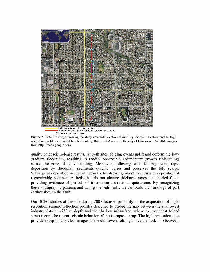
Figure 2. Satellite image showing the study area with location of industry seismic reflection profile, high-resolution profile, and initial boreholes along Briercrest Avenue in the city of Lakewood. Satellite images from http://maps.google.com. quality paleoseismologic results. At both sites, folding events uplift and deform the low-gradient floodplain, resulting in readily observable sedimentary growth (thickening) across the zone of active folding. Moreover, following each folding event, rapid deposition by floodplain sediments quickly buries and preserves the fold scarps. Subsequent deposition occurs at the near-flat stream gradient, resulting in deposition of recognizable sedimentary beds that do not change thickness across the buried folds, providing evidence of periods of inter-seismic structural quiescence. By recognizing these stratigraphic patterns and dating the sediments, we can build a chronology of past earthquakes on the fault. Our SCEC studies at this site during 2007 focused primarily on the acquisition of high-resolution seismic reflection profiles designed to bridge the gap between the shallowest industry data at ~250 m depth and the shallow subsurface, where the youngest folded strata record the recent seismic behavior of the Compton ramp. The high-resolution data provide exceptionally clear images of the shallowest folding above the backlimb between

Figure 3. (A) High-resolution seismic reflection profile acquired along Briercrest Avenue, a north-south street in the city of Lakewood. Short orange lines show 2007 boreholes. Dashed yellow line indicates location of synclinal axial surface. (B) Petroleum-industry profile along Bellflower Blvd ~200 m west of Briercrest Avenue. Yellow dashed line indicated location of synclinal axial surface. Strong reflector at ~1 km depth at the north end of the profile is also clearly discernible in the high-resolution profile. ~60 m and 900 m depth, overlapping with the uppermost reflectors visible on the industry data (Fig. 3). These data demonstrate that the growth triangle narrows upward from ~1,000 m at 200 m depth, to <200 m width at 60 m depth, providing an ideal target for borehole analysis. In addition to our acquisition of the high-resolution data, we also drilled five, 35-m-deep reconnaissance boreholes. The continuous cores, together with

five 14C dates, reveal laterally extensive, well-bedded floodplain sediments, characterized by a fine-grained Holocene section composed of clays, silts, and sands overlying a coarser-grained Pleistocene section made up predominantly of gravels deposited over the past ~17,000 years. Stratigraphic correlations between boreholes us identify a zone of syn-tectonic growth strata dipping to the north, coinciding with a discrete zone of folded strata < 200 m wide. Total uplift across the deformed strata is ~ 8 m, as revealed by the deepest unit, a coarse-grained sand and gravel. Although these boreholes demonstrate excellent stratigraphy and abundant dateable material (organic-rich clays and proto-peats, charcoal, wood fragments), they are too few in number to fully characterize the shallow structure and stratigraphy of the fold. Planned SCEC-funded boreholes to be collected during 2008 will provide a more-complete picture of the details of ancient folding events, and will allow is to more precisely determine the ages and displacements in past Compton Thrust earthquakes. References Dolan, J. F., Christofferson, S., and Shaw, J. H., 2003, Recognition of paleoearthquakes
on the Puente Hills blind thrust fault, Los Angeles, California: Science, v. 300, p. 115-118.
Field, E. H., Seligson, H. A., Gupta, N., Gupta, V., Jordan, T. H., and Campbell, K. W., 2005, Loss estimates for a Puente Hills blind-thrust earthquake in Los Angeles, California: Earthquake Spectra, v. 21, p. 329-338.
Leon, L. A., Christofferson, S. A., Dolan, J. F., Shaw, J. H., and Pratt, T. L., 2007, Earthquake by-earthquake fold growth above the Puente Hills blind thrust fault, Los Angeles, California: Implications for fold kinematics and seismic hazard: Jour. Geophys. Res. – Solid Earth, 112, B03S03, doi:10.1029/2006JB004461.
Mueller, K. J., 1998, Recency of folding along the Compton-Los Alamitos trend: Implications for seismic risk in the Los Angeles basin: EOS, v. 78, p. F702.
Oskin, M., K Sieh, T. Rockwell, G. Miller, P. Guptill, M. Curtis, S. McArdle, and P. Elliot, 2000, Active parasitic folds on the Elysian Park anticline: Implications for seismic hazard in central Los Angeles, California: Geol. Soc. Am. Bull, 112/5, 693-707.
Pratt, T. L., Shaw, J. H., Dolan, J. F., Christofferson, S., Williams, R. A., Odum, J. K. and Plesch, A., 2002, Shallow folding imaged above the Puente Hills blind-thrust fault, Los Angeles, California: Geophys. Res. Lett., v. 29, p. 18-1 to 18-4 (May 8, 2002).
Plesch, A., Shaw, J. & SCEC USR focus group members, 2004, Community Fault Model (CFM) and Community Block Model (CBM) for Southern California, SCEC Annual Meeting, Palm Springs, CA.
Schneider, C., Hummon, C., Yeats, R. S., and Huftile, G. J., 1996, Structural evolution of the northern Los Angeles basin, California, based on growth strata: Tectonics, v. 15, p. 341-355.
Shaw, J. H., and Suppe, J., 1994, Active faulting and growth faulting in the eastern Santa Barbara Channel, California: Geol. Soc. Amer. Bull., v. 106, p. 607-626.
Shaw, J. H., and Suppe, J., 1996, Earthquake hazards of active blind thrust faults under the central Los Angeles Basin, California: J. Geophys. Res., v. 101, p. 8623-8642.
Shaw, J. H., and Shearer, P. M., 1999, An elusive blind thrust fault beneath metropolitan Los Angeles: Science, v. 283, p. 1516-1518.
Shaw, J. H., M.P. Suess, C. Rivero, 1999, Structural and seismologic investigations of concealed earthquake sources in the Los Angeles metropolitan area, SCEC Annual Meeting Poster Presentation, Palm Springs, CA.
Shaw, J. H., Plesch, A., Dolan, J. F., Pratt, T., and Fiore, P., 2002, Puente Hills blind-thrust system, Los Angeles basin, California: Bull. Seismol. Soc. Amer., v. 92, p. 2946-2960.