2.0 SAN JUAN RIVER BASIN BACKGROUND 2.1 Description · PDF file2.0 SAN JUAN RIVER BASIN...
9
2.0 SAN JUAN RIVER BASIN BACKGROUND 2.1 Description and Land Ownership The entire San Juan River basin encompasses portions of New Mexico, Colorado, Utah, and Arizona. The New Mexico portion extends into portions of McKinley, San Juan, and Rio Arriba counties in the northwestern portion of the state. The geographic area of the 2002 Surface Water Quality Bureau (SWQB) study was from the Navajo Nation boundary at the Hogback to Navajo Dam, as well as tributaries that enter the San Juan River in this area. Land ownership/management in the New Mexico portion of the San Juan River basin upstream of the Hogback includes the US Forest Service (USFS), US Bureau of Land Management (BLM), Native American (Navajo Nation, Ute Mountain Ute, and Jicarilla Apache), State, and Private (Figure 2.1). 2.2 Geology The San Juan Basin lies on the Colorado Plateau. Several formations of Tertiary and Cretaceous age compose the consolidated geology in the New Mexico portion of the San Juan River basin (Table 2.1, Figures 3.1- 3.3 ). The predominant geologic formation is the Nacimiento Formation of Tertiary age which underlies the soils and crops out along nearly all of the reach of the San Juan River valley east of Farmington (Blanchard et al. 1993). The Cretaceous Kirtland and Fruitland Formation and the Mancos Shale layers underlie the soils and crop out west of the Hogback. These two formations underlie tile soils and compose the outcrop in most of the upland area south of the San Juan River. Near Farmington, Cretaceous rocks rise sharply in some areas, forming hogback ridges (Chronic 1987). All of the shales of Cretaceous age consist at least in part of gray arid black shale. The San Juan River valley is composed in part of Quaternary unconsolidated sand, gravel, silt, clay, and terrace gravel and boulder deposits. Valley soils typically are derived from sandstone, shale, siltstone, and mudstone and range in permeability from moderately rapid to moderately slow (Blanchard et al. 1993). 6
Transcript of 2.0 SAN JUAN RIVER BASIN BACKGROUND 2.1 Description · PDF file2.0 SAN JUAN RIVER BASIN...
2.0 SAN JUAN RIVER BASIN BACKGROUND
2.1 Description and Land Ownership
The entire San Juan River basin encompasses portions of New Mexico, Colorado, Utah, and Arizona. The New Mexico portion extends into portions of McKinley, San Juan, and Rio Arriba counties in the northwestern portion of the state. The geographic area of the 2002 Surface Water Quality Bureau (SWQB) study was from the Navajo Nation boundary at the Hogback to Navajo Dam, as well as tributaries that enter the San Juan River in this area. Land ownership/management in the New Mexico portion of the San Juan River basin upstream of the Hogback includes the US Forest Service (USFS), US Bureau of Land Management (BLM), Native American (Navajo Nation, Ute Mountain Ute, and Jicarilla Apache), State, and Private (Figure 2.1).
2.2 Geology
The San Juan Basin lies on the Colorado Plateau. Several formations of Tertiary and Cretaceous age compose the consolidated geology in the New Mexico portion of the San Juan River basin (Table 2.1, Figures 3.1- 3.3 ). The predominant geologic formation is the Nacimiento Formation of Tertiary age which underlies the soils and crops out along nearly all of the reach of the San Juan River valley east of Farmington (Blanchard et al. 1993). The Cretaceous Kirtland and Fruitland Formation and the Mancos Shale layers underlie the soils and crop out west of the Hogback. These two formations underlie tile soils and compose the outcrop in most of the upland area south of the San Juan River. Near Farmington, Cretaceous rocks rise sharply in some areas, forming hogback ridges (Chronic 1987). All of the shales of Cretaceous age consist at least in part of gray arid black shale. The San Juan River valley is composed in part of Quaternary unconsolidated sand, gravel, silt, clay, and terrace gravel and boulder deposits. Valley soils typically are derived from sandstone, shale, siltstone, and mudstone and range in permeability from moderately rapid to moderately slow (Blanchard et al. 1993).
6

Table 2.1 Geologic Unit Definitions for the San Juan River Basin (see Figures 3.1 – 3.3)
Geologic Unit Code Definition Kch Cliff House sandstone; transgressive marine sandstone Kkf Kirtland and Fruitland Formations; coal-bearing, coal primarily in the Fruitland; Campanian to
Maastrichtian Kl Lower Cretaceous, undivided Km Mancos Shale; divided into Upper and Lower parts by Gallup Sandstone Kmf Menefee Formation; mudstone, shale, and sandstone; coal-bearing Kmv Mesaverde Group; cretaceous sandstones that cap the mesas; includes Kmf, Kch, Kpl
Kpc Pictured cliff sandstone; prominent cliff forming marine sandstone Kpl Point Lookout sandstone; regressive marine sanstone QTp Older Piedmont alluvial deposit and shallow basin fill QTs Upper Santa Fe Group Qal Alluvium, Qa
TKa Combination of Tertiary and Cretaceous (age) rock units TKi Paleogene and Upper Cretaceous intrusive rocks TKoa Ojo Alamo Formation; fine- to medium-grained sedimentary sandstone; Toa; named after a New
Mexico trading post where it was first found. The trading post in turn was named after a large cottonwood tree (called alamo in Spanish) that grew next to the spring nearby (http://www.palaeos.com/Vertebrates/Units/Unit330/330.600.html)
Tn Nacimiento Formation; discontinuous fluvial sandstone Tsj San Jose Formation; stacked alluvial and fluvial sandstones with lateral discontinuities; recognized by
rounded-ledge outcrops
2.3 Water Quality Standards
Water quality standards (WQS) for all assessment units in this document are set forth in the following various sections of New Mexico Standards for Interstate and Intrastate Surface Waters (NM Administrative Code [NMAC] 20.6.4) (NMAC 2002): 20.6.4.402 SAN JUAN RIVER BASIN - La Plata river from its confluence with the San Juan river upstream to the New Mexico-Colorado line.
A. Designated Uses: irrigation, limited warmwater fishery, marginal coldwater fishery, livestock watering, wildlife habitat, and secondary contact.
B. Standards: (1) In any single sample: pH shall be within the range of 6.6 to 9.0 and temperature shall not exceed 32.2°C (90°F). The use-specific numeric standards set forth in 20.6.4.900 NMAC are applicable to the designated uses listed above in Subsection A of this section. (2) The monthly geometric mean of fecal coliform bacteria shall not exceed 200/100 mL; no single sample shall exceed 400/100 mL (see Subsection B of 20.6.4.13 NMAC).
20.6.4.403 SAN JUAN RIVER BASIN - The Animas river from its confluence with the San Juan
upstream to U.S. highway 550 at Aztec. A. Designated Uses: municipal and industrial water supply, irrigation, livestock watering, wildlife
habitat, marginal coldwater fishery, secondary contact, and warmwater fishery. B. Standards:
7
(1) In any single sample: pH shall be within the range of 6.6 to 9.0, and temperature shall not exceed 27°C (80.6°F). The use-specific numeric standards set forth in 20.6.4.900 NMAC are applicable to the designated uses listed above in Subsection A of this section. (2) The monthly geometric mean of fecal coliform bacteria shall not exceed 200/100 mL; no single sample shall exceed 400/100 mL (see Subsection B of 20.6.4.13 NMAC).
NMAC 20.6.4.900 provides standards applicable to attainable or designated uses unless otherwise specified in 20.6.4.101 through 20.6.4.899. NMAC 20.6.4.12 lists general standards that apply to all surface waters of the state at all times, unless a specified standard is provided elsewhere in NMAC. The New Mexico Environment Department (NMED) proposed a variety of modifications to San Juan River basin water quality standard segments during the February 2004 triennial review hearings. Most notable,
• The description of segment 20.6.4.401 will be changed to “The main stem of the San Juan river from the Navajo Nation at the Hogback upstream to its confluence with the Animas River” to acknowledge that New Mexico does not have jurisdiction over surface water quality standards in the San Juan River downstream of the Hogback. New Mexico and the Navajo Nation share jurisdiction on the main stem of the San Juan river from the Navajo Nation at the Hogback upstream to its confluence with the La Plata River. A new water quality standard segment (20.6.4.408) will cover the San Juan River from the Animas River to Cañon Largo. This split will not impact any current or proposed water quality criteria.
• Animas River 20.6.4.403 designated contact use of “secondary contact” was changed to
“primary contact.” The change was made to recognize that swimming has been observed as an existing use in this portion of the Animas River.
Proposed changes to the standards are still under review and have not been approved by USEPA at the time of this writing. Accordingly, this TMDL document was prepared using the existing water quality standards (NMAC 2002).
8

Figure 2.1 San Juan River Basin Land Ownership
9
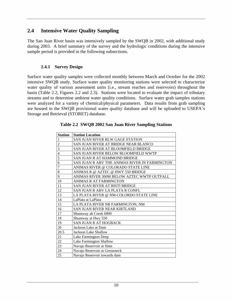
2.4 Intensive Water Quality Sampling
The San Juan River basin was intensively sampled by the SWQB in 2002, with additional study during 2003. A brief summary of the survey and the hydrologic conditions during the intensive sample period is provided in the following subsections.
2.4.1 Survey Design
Surface water quality samples were collected monthly between March and October for the 2002 intensive SWQB study. Surface water quality monitoring stations were selected to characterize water quality of various assessment units (i.e., stream reaches and reservoirs) throughout the basin (Table 2.2, Figures 2.2 and 2.3). Stations were located to evaluate the impact of tributary streams and to determine ambient water quality conditions. Surface water grab samples stations were analyzed for a variety of chemical/physical parameters. Data results from grab sampling are housed in the SWQB provisional water quality database and will be uploaded to USEPA’s Storage and Retrieval (STORET) database.
Table 2.2 SWQB 2002 San Juan River Sampling Stations
Station Station Location 1 SAN JUAN RIVER BLW GAGE STATION 2 SAN JUAN RIVER AT BRIDGE NEAR BLANCO 3 SAN JUAN RIVER AT BLOOMFIELD BRIDGE 4 SAN JUAN RIVER BELOW BLOOMFIELD WWTP 5 SAN JUAN R AT HAMMOND BRIDGE 6 SAN JUAN R ABV THE ANIMAS RIVER IN FARMINGTON 7 ANIMAS RIVER @ COLORADO STATE LINE 8 ANIMAS R @ AZTEC @ HWY 550 BRIDGE 9 ANIMAS RIVER 300M BELOW AZTEC WWTP OUTFALL 10 ANIMAS R AT FARMINGTON 11 SAN JUAN RIVER AT BISTI BRIDGE 12 SAN JUAN R ABV LA PLATA R CONFL 13 LA PLATA RIVER @ NM-COLORDO STATE LINE 14 LaPlata at LaPlata 15 LA PLATA RIVER NR FARMINGTON, NM 16 SAN JUAN RIVER NEAR KIRTLAND 17 Shumway ab Creek 6800 18 Shumway at Hwy 550 19 SAN JUAN R AT HOGBACK 20 Jackson Lake at Dam 20.5 Jackson Lake Shallow 21 Lake Farmington Deep 22 Lake Farmington Shallow 23 Navajo Reservoir at Sims 24 Navajo Reservoir at Gooseneck 25 Navajo Reservoir towards dam
10

Figure 2.2 Animas River Land Use/Cover and Sampling Stations
11

Figure 2.3 Middle San Juan River Land Use/Cover and Sampling Stations
12

In 2003, additional nutrient assessment data was collected in the Animas River as part of the Animas River Nutrient Work Group efforts. In 2002, SWQB applied for and received a CWA Section 104(b)(3) grant to develop a protocol for determination of sedimentation/siltation impairment in large southwest rivers. The San Juan and Animas Rivers were chosen as case studies for this protocol. Data collection occurred fall of 2003. Section 4.0 addresses the supplementary nutrient assessment efforts. Additional information on sedimentation/siltation was previously addressed in the Final Total Maximum Daily Load (TMDL) for the San Juan River Watershed (Part 1) (NMED/SWQB 2005). All sampling and assessment techniques used during the 2002-2003 intensive SWQB survey are detailed in the Quality Assurance Project Plan (QAPP) (NMED/SWQB 2001), assessment protocols (NMED/SWQB 2004b), and U.S. Department of Agriculture (USDA) National Sedimentation Lab (NSL) study (Heins et al., 2004). As a result of the 2002 and 2003 monitoring efforts, several surface water impairments were determined. Accordingly, these impairments were added to New Mexico’s 2004-2006 CWA Integrated §303 (d)/305(b) list (NMED/SWQB 2004a).
2.4.2 Hydrologic Conditions
There are three active, real-time U.S. Geological Survey (USGS) gaging stations in the San Juan River basin associated with the reaches presented in this document. USGS gage locations are presented in Figures 2.2 and 2.3. Daily stream flow for these USGS gages are presented graphically in Figures 2.4 through 2.6 for the 2002 calendar year.
Figure 2.4 2002 USGS Average Daily Flow, Animas River near Cedar Hill, NM
13
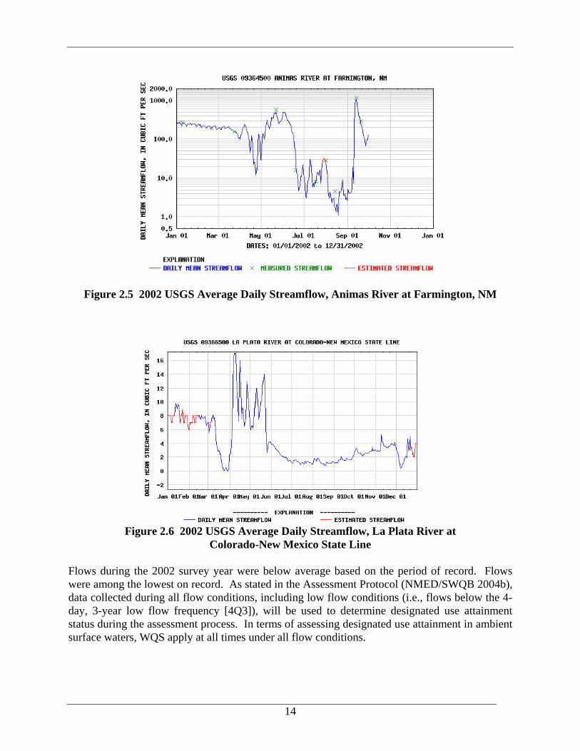
Figure 2.5 2002 USGS Average Daily Streamflow, Animas River at Farmington, NM
Figure 2.6 2002 USGS Average Daily Streamflow, La Plata River at Colorado-New Mexico State Line
Flows during the 2002 survey year were below average based on the period of record. Flows were among the lowest on record. As stated in the Assessment Protocol (NMED/SWQB 2004b), data collected during all flow conditions, including low flow conditions (i.e., flows below the 4-day, 3-year low flow frequency [4Q3]), will be used to determine designated use attainment status during the assessment process. In terms of assessing designated use attainment in ambient surface waters, WQS apply at all times under all flow conditions.
14