2.0 INVENTORY
63
2.0 INVENTORY This chapter provides a detailed explanation of the general condition and composition of the current facilities encompassing EGE. Information pertaining to the airport including the airfield, Navigational Aid Systems (NAVAIDs), pavement condition, parking, ground access, and utilities are all included in this chapter. Table 2-1 and Table 2-2 summarize the major landside and airside components of EGE. All items listed will be discussed in greater detail throughout Section 2.0. The primary airport facilities are depicted graphically in Figure 2-1. TABLE 2-1 – AIRFIELD PAVEMENT INVENTORY Item Description Condition Runway 7/25 • 9,000 feet by 150 feet • 25 foot Paved Shoulders • Consists of Dense Graded Grooved Asphalt • Published Strength: 75,000 lb Single Wheel Gear (SWG), 175,000 lb Single Tandem Wheel Gear (STG), 140,000 lb (DWG), 255,000 lb Double Tandem Wheel Gear (DTG) Excellent Taxiways Refer to Section 2.2.2 Apron • Commercial: 697,000 square feet • General Aviation (GA): 1,093,536 square feet - North GA: 207,642 - South GA: 885,894 • Colorado Army National Guard: 411,110 square feet Average/Fair Average/Poor Fair/Poor Source: Jviation, Inc 2/11/2014 2-1
Transcript of 2.0 INVENTORY

2.0 INVENTORY This chapter provides a detailed explanation of the general condition and composition of the current facilities encompassing EGE. Information pertaining to the airport including the airfield, Navigational Aid Systems (NAVAIDs), pavement condition, parking, ground access, and utilities are all included in this chapter.
Table 2-1 and Table 2-2 summarize the major landside and airside components of EGE. All items listed will be discussed in greater detail throughout Section 2.0. The primary airport facilities are depicted graphically in Figure 2-1.
TABLE 2-1 – AIRFIELD PAVEMENT INVENTORY Item Description Condition
Runway 7/25 • 9,000 feet by 150 feet
• 25 foot Paved Shoulders
• Consists of Dense Graded Grooved Asphalt
• Published Strength: 75,000 lb Single Wheel Gear (SWG), 175,000 lb Single Tandem Wheel Gear (STG), 140,000 lb (DWG), 255,000 lb Double Tandem Wheel Gear (DTG)
Excellent
Taxiways Refer to Section 2.2.2 Apron • Commercial: 697,000 square feet
• General Aviation (GA): 1,093,536 square feet - North GA: 207,642 - South GA: 885,894
• Colorado Army National Guard: 411,110 square feet
Average/Fair Average/Poor
Fair/Poor
Source: Jviation, Inc
2/11/2014 2-1
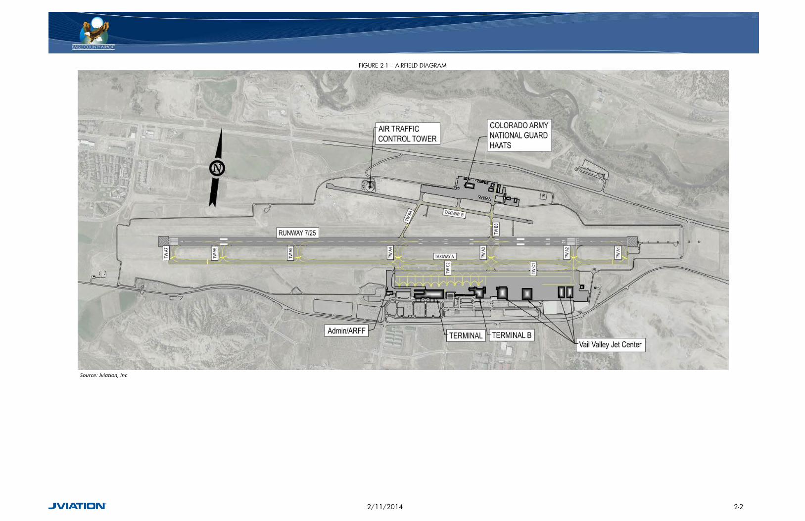
FIGURE 2-1 – AIRFIELD DIAGRAM
Source: Jviation, Inc
2/11/2014 2-2

TABLE 2-2 – AIRPORT FACILITIES INVENTORY
Item Description
Navigational Aids
• Localizer Type Directional Aid (LDA)/Distance Measuring Equipment (DME)
• Area Navigation (RNAV) • Instrument Landing System (ILS)
Visual Aids
• High Intensity Runway Lights (HIRL) • Non-precision Markings (7) Precision Markings (25) • Medium Intensity Approach Lighting System with Runway Alignment
Indicator Lights (MALSR) – Runway 25 • Precision Approach Path Indicators (PAPI) • Runway End Identifier Lights (REIL) – Runway 7 • Airport Rotating Beacon • Runway & Taxiway Edge Lights • Runway Distance Remaining Signs (RDR) • Runway & Taxiway Guidance Signs
FBO (Vail Valley Jet Center) Building 39,000 square feet Terminal Building 80,000 square feet
Parking
• Short-term – 554 Spaces • Long-term – 464 Spaces • Commercial – 95 Spaces • Overflow – 306 Spaces • Rental Car
- Ready Lot – 240 Spaces - Return Lot – 163 Spaces
Source: Jviation, Inc
2.1 AIRPORT REFERENCE CODE The FAA classifies airports in the United States with a coding system known as the Airport Reference Code (ARC). This classification helps apply design criteria appropriate to operational and physical characteristics of the aircraft types that operate at the airport. The ARC is made up of two separate components: Aircraft Approach Category, designated with letters A through E; and the Aircraft Design Group (ADG), denoted by roman numerals I through VI.
The Aircraft Approach Category is an alphabetical classification of an aircraft based on 1.3 times the stall speed in a landing configuration at their maximum certified landing weight. Category A represents the slowest approach speed, while E is the fastest. The approach category for an airport is determined by the approach speed of the fastest aircraft that operates at the airport at least 500 times per year. The categories are listed in Table 2-3.
2/11/2014 2-3

TABLE 2-3 – AIRCRAFT APPROACH CATEGORY
Approach Category Approach Speed A <91 B 91≤121 C 121≤141 D 141≤166 E >166
Source: FAA AC 150/5300-13
The ADG is a numerical classification of aircraft based on wingspan or tail height. If an airplane is in two categories, the most demanding category should be used. Similar to the approach category, the ADG for an airport is determined by the largest aircraft operating at least 500 times per year at the facility. The groups are identified in Table 2-4, and examples of ARC aircraft types are shown in Figure 2-2.
For EGE, the ARC is currently D-IV based on the critical aircraft currently operating at the airport, which is a Boeing 757.
TABLE 2-4 – AIRCRAFT DESIGN GROUP (ADG)
Group Tail Height (ft) Wingspan(ft) I <20 <49 II 20≤30 49≤79 III 30≤45 79≤118 IV 45≤60 118≤171 V 60≤66 171≤214 VI 66≤80 214≤262
Source: FAA AC 150/5300-13
2/11/2014 2-4
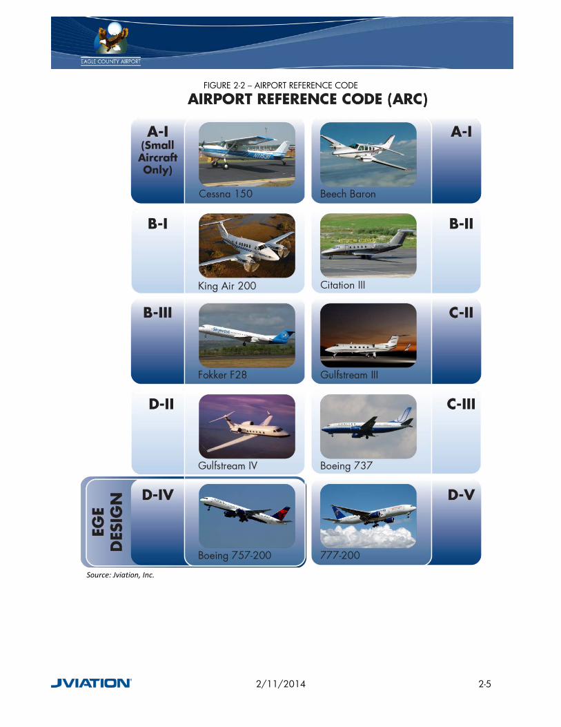
FIGURE 2-2 – AIRPORT REFERENCE CODE
Source: Jviation, Inc.
2/11/2014 2-5

2.2 AIRFIELD / AIRSPACE
2.2.1 RUNWAYS EGE’s airfield configuration consists of one active runway, designated as Runway 7/25, as depicted in Figure 2-1. Runway 7/25 is positioned nearly east/west, and is 9,000 feet long by 150 feet wide with 25 foot paved shoulders. This runway utilizes a special Instrument Landing System (ILS) that incorporates dual localizers and distance measuring equipment (DME) at the end of Runway 7.
Runway 7/25 is constructed to support a weight-bearing capacity of no greater than 75,000 lb for Single Wheel Gear (SWG) equipped aircraft, 140,000 lb for Double Wheel Gear (DWG) equipped aircraft, and 255,000 lb for Double Tandem Wheel Gear (DTG) equipped aircraft. The runway is constructed with grooved dense graded asphalt.
Per the FAA Airport Master Record (FAA Form 5010-1), the current Airport Reference Point (ARP) is located at Latitude N 39º 38’ 33.94” and Longitude W 106º 54’ 57.965”.The ARP is the latitude and longitude of the approximate center of the runway. The established airport elevation, defined as the highest point on the airport’s runway, is 6,547.5 feet above mean sea level (MSL) and is located at the east end of Runway 25.
Aircraft compasses and runway identifiers utilize magnetic north for directional guidance. For this reason, it is important to evaluate an airport’s runway numerals every few years to ensure that the numbers painted on the runway truly represent the magnetic heading of the runway. The magnetic forces across the planet are constantly shifting, and therefore a declination must be applied to a compass to arrive at a true north heading. The current true bearing for Runway 7 is 81° 55’ 46.131” and 261° 56’ 58.785’’ for Runway 25. According to the National Geophysical Data Center, as of July 18, 2011, the current declination for EGE is 9° 51’ east and is changing by 0° 7’ per year. Applying this declination to the true bearing results in a magnetic heading of 72.410° for Runway 7 and 252.43° for Runway 25. This means that the current runway designations of 7 and 25 are still correct and do not require adjustment.
2.2.2 TAXIWAYS The taxiway system at EGE is constructed of asphalt and consists of one full length parallel taxiway (Taxiway A) on the south side of Runway 7/25, one partial parallel taxiway (Taxiway B) on the north side, and several connector taxiways. Taxiway A and the associated connector taxiways, are 75 feet wide, and are built to accommodate ADG-IV (maximum 171 foot wingspan) aircraft while Taxiway B and the associated connector taxiways, are 35 feet wide, and can only accommodate ADG-II (maximum 79 foot wingspan) aircraft. Refer to Table 2-5 for an overview of the existing taxiways and Figure 2-1 for the taxiway layout.
2/11/2014 2-6

TABLE 2-5 – TAXIWAY SYSTEM Taxiway Description Condition
A Full length parallel taxiway on the south end of Runway 7/25. Very Good
A1 Taxiway connector from parallel Taxiway A to the displaced threshold of Runway 25. Excellent
A2 Taxiway connector from parallel Taxiway A to the threshold of Runway 25. Very Good
A3 Taxiway connector from parallel Taxiway A to both Runway 7/25 and Commercial/FBO Apron. Very Good
A4 Taxiway connector from parallel Taxiway A to the midpoint of Runway 7/25 and the Commercial Apron. Very Good
A5 Taxiway connector from parallel Taxiway A to Runway 7/25. Very Good A6 Taxiway connector from parallel Taxiway A to Runway 7/25. Very Good A7 Taxiway connector from parallel Taxiway A to the threshold of Runway 7. Very Good
B Partial parallel taxiway on north side of Runway 7/25. Serves the HAATS operations and the north GA Apron and Hangars. Poor
B3 Taxiway connector from parallel Taxiway B to Runway 7/25 and across to Taxiway A3. Fair/Poor
B4 Taxiway connector from parallel Taxiway B to Runway 7/25 and across to Taxiway A4. Fair/Poor
C1 Taxiway connector from the east end of the FBO Apron to parallel Taxiway A. Fair
C2 Taxiway connector from the middle of the Commercial Apron to parallel Taxiway A. Fair
Source: Jviation, Inc
2.2.3 APRON There are several aprons serving different needs at EGE, as depicted in Figure 2-3. Both the Commercial Aviation Apron and the General Aviation (GA) Apron for the FBO are located south of the runway. There are two aprons located on the north side of Runway 7/25. These include the Colorado Army National Guard Apron, which supports the HAATS site, as well as an additional GA Apron to the east of the HAATS facility, serving the associated GA hangars.
2/11/2014 2-7

FIGURE 2-3 – APRON AREA
Source: Jviation, Inc
DRAFT 2/11/2014 2-8

2.2.4 PAVEMENT CONDITION The FAA recommends in Advisory Circular 150/5380-6b, Guidelines and Procedures for Maintenance of Airport Pavements, that a detailed pavement inspection be conducted that follows the American Society for Testing and Materials (ASTM) D 5340, Standard Test Method for Airport Pavement Condition Index Surveys. This method employs a visual rating system for pavement distress and is known as the Pavement Condition Index (PCI).
The last major PCI study performed by the Colorado Department of Transportation (CDOT), Division of Aeronautics, for EGE was completed in 2010. In 2009, Runway 7/25 was reconstructed and extended by 1,000feet. Parallel Taxiway A was also extended by 1,000 feet, however the remaining pavement was not touched. Incorporating this recent rehabilitation project into the study, the surfaces at EGE are found to be in a range from very poor to excellent condition. Surfaces on the north and south GA Aprons, Taxiway B, and the Commercial Apron are found to be very poor to fair with some areas being good.
Figure 2-4 gives a visual representation of the current pavement condition for the aprons at EGE. The commercial and south GA aprons are currently being designed for rehabilitation due to non-standard grades, deterioration of concrete by alkali silica reaction (ASR), and general Foreign Object Debris (FOD) issues. Construction for this project will be phased over a five year span.
2.2.5 LIGHTING, MARKING, AND SIGNAGE OF RUNWAY AND TAXIWAYS Airfield lighting and markings meet FAA standards for marking and lighting for precision and non-precision approaches. Runway 7/25 is equipped with a High Intensity Runway Lighting (HIRL) system. They HIRL system was installed as part of the Runway 7/25 extension project, completed in 2009, and is in excellent condition. All taxiways are equipped with Medium Intensity Taxiway Lighting (MITL). While the majority of the existing MITL lighting system is in good condition, the MITL system along Taxiway A from Taxiway A1 to A2 is in excellent condition, as it was installed as part of the runway extension project. Runway 25 is marked with precision instrument markings, while Runway 7 has non-precision markings.
DRAFT 2/11/2014 2-9

FIGURE 2-4 – EGE PAVEMENT CONDITION OVERVIEW
Source: CDOT, Division of Aeronautics; Jviation, Inc.
DRAFT 2/11/2014 2-10

2.2.6 VISUAL AND NAVIGATIONAL AIRPORT AIDS Landing in instrument meteorological conditions is only available using Runway 25. This runway is equipped with Precision Approach Path Indicators (PAPIs) providing a three-degree glide slope to arriving aircraft. A PAPI is a light system normally positioned on the north side of the runway which is constructed with four box lights in a row. These lights can be detectable from up to five miles during the day, and 20 miles or more at night. Additionally, Runway 7 is equipped with Runway End Identifier Lights (REILs). These flashing lights are situated on both sides of the runway threshold, and indicate the beginning of the usable runway for approaching aircraft. A Medium Intensity Approach Lighting System with Runway Alignment Indicator Lights (MALSR) is installed at the end of Runway 25 and helps transition from instrument flying to a visual approach and landing. It allows the pilot to visually identify and align the aircraft with the runway environment once the pilot has arrived at a prescribed point on the approach. Runway 25 is equipped a localizer approach which provides the horizontal position of an aircraft relative to the runway centerline, and a glide slope that provides vertical guidance to the touchdown point on the runway.
A Global Positioning System (GPS) approach is published for Runway 25, as discussed in greater detail in Section 2.2.7.
There are several VHF Omnidirectional Radio range (VOR) stations in the vicinity of EGE. A VOR broadcasts a VHF radio signal, including a navigational component that allows aircraft to navigate from point to point following the signals. The Snow (SXW) VOR is 3.6 nautical miles (NM) to the southwest of the airfield and is on frequency 109.2. EGE is on the 065º radial from this VOR/DME. In addition to the Snow VOR, the Rifle (RGA) VOR/DME (frequency 111.45) is located approximately 39 NM south-southwest on the 247º radial. Also, approximately 12 NM south is Red Table (DBL) VOR/DME (frequency 113.0) on the 162º radial, and on a 032ºradial 31 NM north-northeast is the Kremmling (RLG) VOR/DME.
2.2.7 INSTRUMENT APPROACH EQUIPMENT AND PROCEDURES EGE is surrounded by mountainous terrain, limiting radar coverage from the Denver Air Route Traffic Control Center (ARTCC), the control center in which clearances are given for all Instrument Flight Rule (IFR) approaches. IFR approaches are used to guide aircraft to the runway environment during times of reduced visibilities and cloud heights (ceiling) also known as Instrument Meteorological Conditions (IMC). Approach minimums are based upon several factors, including obstructions, navigation equipment, approach lighting, and weather reporting equipment. Due to FAA obstruction clearance requirements, the primary impact to approach mountainous terrain impacts instrument approaches resulting in higher approach minima (ceiling and visibility parameters) at EGE.
Currently the FAA recognizes three instrument approach types; Precision, Approach with Vertical Guidance (APV) and Nonprecision. Following are the FAA definitions of these approach types:
DRAFT 2/11/2014 2-11
Precision Approach - An instrument approach procedure providing course and vertical path guidance conforming International Civil Aviation Organization (ICAO) annex 10 requirements. ILS, Precision Approach Radar, and MLS are examples of precision approaches and are commonly referred to in the context of conventional approach technologies via the use of ground based navigational aids.
Approach Procedure with Vertical Guidance (APV) - An instrument approach based on a navigation system that is not required to meet the precision approach standards of ICAO Annex 10 but provides course and glidepath deviation information. Baro-VNAV, LDA with glidepath, LNAV/VNAV and LPV are examples of APV approaches. Guidance provided for APV approaches via GPS do not require the use of ground-based navigational aids.
Nonprecision Approach - An instrument approach based on a navigation system which provides course deviation information, but no glidepath deviation information. VOR, NDB, LNAV, and circling minima are examples of nonprecision approaches. Guidance provided for nonprecision approaches via GPS do not require the use of ground-based navigational aids.
Instrument Landing Systems (ILS) approaches are broken into three categories: CAT I, CAT II, and CAT III, based on minimum altitudes an aircraft is capable of descending. CAT I systems are the most common ILS found at airports, as CAT II and CAT III systems allow for lower minimum altitudes, and require increased airport investments. It is important to point out that use of these approaches is subject aircraft being properly equipped and certified and properly trained aircrew.
GPS satellite based instrument approaches follow the same basic guidelines as ground-based systems, with the lowest possible minimums for approaches with horizontal only guidance being 300-1. With the addition of vertical guidance through Wide Area Augmentation System (WAAS) or Ground Bases Augmentation System (GBAS), the lowest minimums are generally 200- ½. The visibility can be reduced by ¼ mile with the installation of an approach lighting system.
Currently, Runway 25 has two published nonprecision approaches: a RNAV (GPS)-D approach and a LDA/DME approach. In addition to these published approaches, Runway 25 has two non-published approaches known as “Specials”. These Specials require special aircraft and aircrew authorization through the FAA Flight Standards District Office (FSDO) prior to use. One Special is an ILS or Localizer (LOC) with Distance Measuring Equipment (DME) approach. Surrounding terrain prevents a standard three-degree ILS glide slope resulting in a non-standard ILS glideslope of 3.8 degrees. The other Special is a LOC Flight Management System (FMS) approach. Figure 2-5 below shows the dual localizer used for Special (precision) instrument approaches. While not available to the general flying public, these Specials are available for use by all users who are willing to obtain authorization from the FAA. There are currently no approaches to Runway 7. Table 2-6 provides summary of information regarding each approach at EGE, including the lowest minimums available. The current published instrument approach charts and departure procedures are included
2/11/2014 2-12

in Appendix B. Access to the Special Procedures is restricted by the airport and the FAA and, therefore, are not included in the appendix.
TABLE 2-6 – EGE INSTRUMENT APPROACHES
Runway 25 Approach Lowest Minimums Decision Height RNAV (GPS) – D (nonprecision) 8,900 – 1 ½ 2,365
LDA/DME (nonprecision) 8,330 – 3 1,790 ILS or LOC DME – Special (precision) 7,480 – 2 ¾ 940
LOC FMS (APV) 7,360 – 2 ¾ 820 Source: Airnav.com & Eagle County Regional Airport
There are several airports in close proximity to EGE that have instrument approach procedures. These airports include Aspen-Pitkin County Airport/Sardy Field, Garfield County Regional Airport, Lake County Airport, Kremmling-McElroy Airfield, and Meeker Airport. These airports are listed in below.
TABLE 2-7– REGIONAL INSTRUMENT APPROACHES
Source: Airnav.com
Additional discussion of instrument approach procedures at EGE is included in Chapter 4, Facility Requirements.
Airport Identifier Distance from EGE (Nautical Miles) Procedures Available
Aspen-Pitkin County Airport/ Sardy Field ASE 25 NM South LOC/DME-E, VOR/DME,
GPS-C
Garfield County Regional Airport RIL 38 NM West ILS, RNAV (GPS),
LOC/DME-A, VOR/DME-C
Lake County Airport LXV 38 NM Southeast GPS Kremmling–McElroy Field 20V 35 NM Northeast GPS, VOR/DME, GPS-A
Meeker Airport EEO 51 NM Northwest RNAV(GPS), RNAV(GPS)-B, VOR-A
2/11/2014 2-13

FIGURE 2-5 – DUAL LOCALIZER
Source: Jviation, Inc.
2.2.8 AIRPORT AIRSPACE USAGE The airspace surrounding EGE is quite complicated and in the vicinity of numerous other mountainous airports with heavy traffic. The airport environment is protected by Class D and Class E Airspace, which are defined as:
Class D Airspace – Generally, the airspace from the surface to 2,500 feet above the airport elevation (charted in MSL) surrounding those airports that have an operational ATCT. The configuration of each Class D airspace area is individually tailored. When instrument procedures are published, the airspace will normally be designed to contain these procedures. Arrival extensions for instrument approach procedures may be in Class D or Class E airspace. Unless otherwise authorized, each person must establish two-way radio communications with the Air Traffic Control (ATC) facility providing air traffic services prior to entering the airspace, and must maintain those communications while in the airspace. No separation services are provided to VFR aircraft.
Class E Airspace – Generally, if the airspace is not Class A, Class B, Class C, or Class D, and it is controlled airspace, it is Class E airspace. Class E airspace extends upward from either the surface or a designated altitude to the overlying or adjacent controlled airspace. When designated as a surface area, the airspace will be configured to contain all instrument procedures. Also in this class are Federal Airways, airspace beginning at either 700 or 1,200 feet above ground level (AGL) used to transition to/from the terminal or en route environment, en route domestic, and offshore airspace areas designated below 18,000 feet Mean Seal Level (MSL). Unless designated at a lower altitude, Class E airspace begins at 14,500 MSL over the United States, including that airspace overlying the waters within 12 NM of the coast of the 48 contiguous United States and Alaska, up to, but not including 18,000 feet MSL, and the airspace above Flight Level 600 (60,000 feet).
2/11/2014 2-14
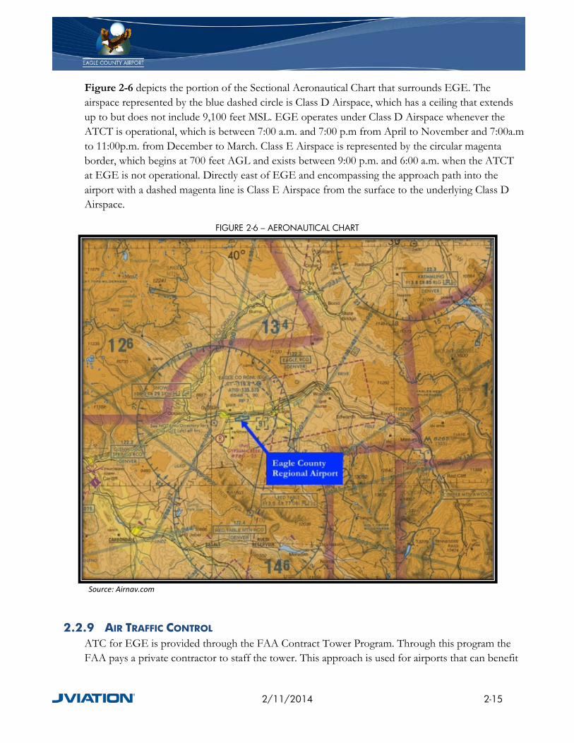
Figure 2-6 depicts the portion of the Sectional Aeronautical Chart that surrounds EGE. The airspace represented by the blue dashed circle is Class D Airspace, which has a ceiling that extends up to but does not include 9,100 feet MSL. EGE operates under Class D Airspace whenever the ATCT is operational, which is between 7:00 a.m. and 7:00 p.m from April to November and 7:00a.m to 11:00p.m. from December to March. Class E Airspace is represented by the circular magenta border, which begins at 700 feet AGL and exists between 9:00 p.m. and 6:00 a.m. when the ATCT at EGE is not operational. Directly east of EGE and encompassing the approach path into the airport with a dashed magenta line is Class E Airspace from the surface to the underlying Class D Airspace.
FIGURE 2-6 – AERONAUTICAL CHART
Source: Airnav.com
2.2.9 AIR TRAFFIC CONTROL ATC for EGE is provided through the FAA Contract Tower Program. Through this program the FAA pays a private contractor to staff the tower. This approach is used for airports that can benefit
2/11/2014 2-15

from a tower but may not meet certain criteria for full-time staffing by FAA personnel. ATC services are provided while the ATCT is operational. The Denver ARTCC provides approach and departure navigation for the airport. This is particularly important due to the high mountainous terrain that surrounds the airport.
2.2.10 OBSTRUCTIONS TO AIR NAVIGATION Although the existing terrain is the controlling obstruction, there is an obstacle procedure when pilots are departing from Runway 7 due to trees that penetrate the departure surface for the runway. A minimum of an 800-foot high ceiling and three miles visibility must be present for aircraft to depart Runway 7.
2.3 COMMERCIAL PASSENGER FACILITIES
2.3.1 TERMINAL BUILDING OVERVIEW The passenger terminal building was constructed in 1996 and includes approximately 80,000 square feet of space. The terminal is located south of Runway 7/25 and is on the west end of the main commercial apron. Inside the terminal, Figure 2-7, are ticket counters, baggage claim, Transportation Security Administration (TSA) offices, aircraft gates, holdrooms, circulation space, concessions, and ground transportation. In addition, four airlines currently lease space throughout the terminal. These airlines include: American, Continental, Delta, United, and United Express.
2.3.2 TICKET COUNTERS The ticket counters are located just inside the main entrance of the terminal with additional curbside ticket counters located at the southeast end of the building. It should be noted that since the airport operates in a seasonal manner, with the peak travel period being the ski season, more airline operations occur during the winter months than the summer months. Non-stop jet services are offered between EGE and ten major U.S. cities by American, Delta, Continental, United, and United Express. These cities include: Atlanta, Chicago, Dallas/Fort Worth, Denver, Houston, Los Angeles, Miami, Minneapolis, New York, and Newark. During the summer, non-stop jet flights between EGE and Dallas/Fort Worth (DFW) are offered on American Airlines, and to Denver (DEN) on United.
2/11/2014 2-16
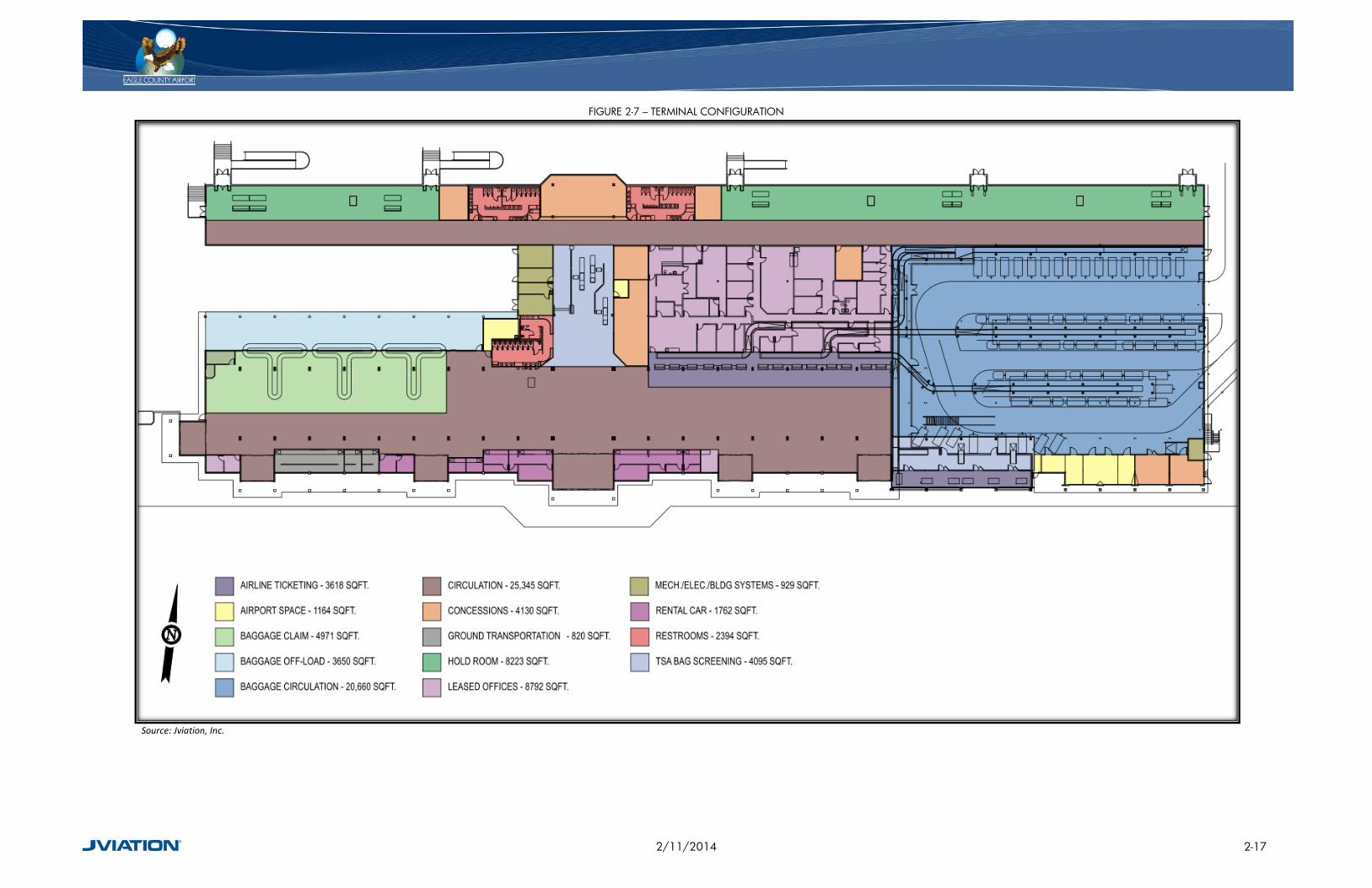
FIGURE 2-7 – TERMINAL CONFIGURATION
Source: Jviation, Inc.
2/11/2014 2-17
2.3.3 OUTGOING BAGGAGE MAKE-UP Outgoing baggage is collected either at curbside check-in, located at the southeast end of the commercial terminal, or inside at the airline ticket counters. From the curbside check-in, bags are taken inside to TSA baggage screening. Baggage checked inside the terminal is immediately screened by TSA baggage screening devices located adjacent to the ticket counter. Luggage that has been screened is placed on a conveyor belt and then collected by the appropriate airline inside the indoor baggage facility. Airlines then load the luggage onto a tug for transfer to the aircraft. Design is currently underway to expand the indoor baggage facility. This expansion will include the addition of inline baggage screening devices and construction is expected to be completed in late fall of 2011.
2.3.4 BAGGAGE CLAIM Passengers can claim their baggage from one of three carousels located on the west end of the commercial terminal. The baggage carousels are located adjacent to commercial transportation and rental car stations.
2.3.5 AIRLINE TICKET OFFICES The airline ticket offices at EGE are located in two areas, as shown in Figure 2-8. One area is at the east end of the commercial terminal at curbside check-in. The second location is inside the commercial terminal at the northeast end of the building. There are also airline offices for baggage claim located at the west end of the terminal in the vicinity of the baggage claim carousels.
2.3.6 TSA FACILITIES The TSA facilities for EGE exist within the commercial terminal, as seen in Figure 2-9. Baggage screening occurs inside the main terminal just east of passenger screening adjacent to the airline ticket counters and also behind curbside baggage claim. Passenger screening occurs in the middle of the terminal immediately across from the main entrance, in between the baggage carousels to the west and ticket counters to the east.
2/11/2014 2-18

FIGURE 2-8 – AIRLINE OFFICES
Source: Jviation, Inc
2/11/2014 2-19

FIGURE 2-9 – TSA SCREENING
Source: Jviation, Inc.
2/11/2014 2-20

2.3.7 AIRCRAFT GATES AND PARKING The concourse does not have any passenger boarding bridges (PLBs). Passengers utilize five gates which provide access to the aircraft on the apron. Access to the aircraft is by air stairs from the apron. Commercial aircraft parking is located directly north of the terminal building and serves ten air carrier parking positions, which are all available for aircraft up to the size of a Boeing 757.
2.3.8 HOLDROOMS The terminal has 8,223 square feet of holdroom area reserved for scheduled outgoing passengers waiting to access their aircraft through one of the five gates.
2.3.9 CIRCULATION The commercial terminal at EGE incorporates a great hall concept in the main terminal area, which allows for passenger circulation space. Main passenger flow occurs in the middle of the terminal. Space is given to the area around the three baggage claim carousels, allowing passengers to easily retrieve their belongings. Circulation in the secured gate area of the terminal is also adequate; however, space becomes more restrictive as passengers flow towards the center of the building to exit the airport due to the concessions and restrooms occupying the north wall.
2.3.10 CONCESSIONS Concessions are located throughout the terminal. There are two coffee shops, a lounge, and a restaurant. Retail concession space totals approximately 1,587 square feet, while roughly 1,869 square feet is available for food and beverage concessions.
2.3.11 RENTAL CAR FACILITIES There are six rental car companies located within the terminal, including Alamo, Avis, Budget, Dollar, Hertz, and National. Also located within the terminal are two ground transportation companies; Colorado Mountain Express and High Mountain Taxi. Rental car service is not limited to commercial passengers, but for GA users and the general public as well.
2.4 CURB FRONT
The curb front is located directly in front of the terminal on the south side of the building. The curb front offers passenger drop off and pickup, and provides curbside check-in for departing passengers.
For passengers using commercial transportation, the drop off location is at the east end of the commercial terminal and pick up occurs at the west end of the commercial terminal, shown in Figure 2-10.
2/11/2014 2-21

FIGURE 2-10 – COMMERCIAL TRANSPORTATION PICK UP AND DROP OFF
Source: Jviation, Inc
2/11/2014 2-22

2.5 GENERAL AVIATION FACILITIES
2.5.1 FIXED BASE OPERATOR EGE has one FBO on the airfield, the Vail Valley Jet Center (VVJC), shown in Figure 2-11. It is located on the south airfield east of the commercial terminal. Services include aircraft line service, apron parking, hangar storage space, on-site catering, and flight planning. Additionally, the FBO provides aircraft fueling for both Jet Fuel and AvGas, along with aircraft maintenance and aircraft deicing.
The VVJC provides the majority of hangar space for transient aircraft. Hangar space is in high demand due to the high traffic that accompanies the ski season and the inclement climate during this peak time.
FIGURE 2-11 – VAIL VALLEY JET CENTER
Source: Jviation, Inc.
2.5.2 AIRPORT HANGARS EGE has several hangars on the airfield. As previously stated, the VVJC provides the majority of hangar space on the main GA Apron with four hangars. These hangars are larger corporate style facilities that can accommodate the business jet traffic common to the airport, especially during the busy ski season. There is one additional privately-owned corporate hangar on the furthest east end of the main GA Apron.
On the north GA Apron, there are nine medium-sized hangars that are either airport or privately owned. In addition to the hangars, there are ten airport-owned, T-Hangar style aircraft storage units. Figure 2-12 provides the overview of aircraft hangar ownership and location on the airport.
2/11/2014 2-23

FIGURE 2-12 – AIRPORT HANGARS
Source: Jviation, Inc
2/11/2014 2-24

2.5.3 BASED AIRCRAFT EGE has a total of 93 based aircraft stored in hangars and on tie-downs. Half (47) of the based aircraft are on the VVJC’s leasehold, while the remaining half (46) are on airport property outside of the VVJC’s leasehold. There currently is no wait list for hangars. A breakdown of based aircraft by type is shown in Table 2-8.
TABLE 2-8 – BASED AIRCRAFT
Aircraft Type Amount Single Engine 46 Multi Engine 13
Jet 20 Glider 3
Helicopters 11 Source: Eagle County Regional Airport
2.5.4 BASED AND TRANSIENT AIRCRAFT PARKING APRONS AND TIE-DOWNS EGE provides based aircraft with tie-down positions on the north GA Apron. These spots are owned by the airport and leased to aircraft owners. Transient aircraft are provided apron parking through the VVJC on the south GA Apron.
Commercial aircraft park on the Commercial Apron between flights. If there is a need for a commercial aircraft to remain overnight, the aircraft will park on the Commercial Apron at a terminal gate.
2.6 AIR CARGO There are no dedicated cargo facilities at EGE. Currently, any cargo that departs/arrives at EGE is transported by commercial airlines.
2.7 SUPPORT FACILITIES
2.7.1 ARFF/SRE BUILDING EGE has one Aircraft Rescue and Firefighting (ARFF) building that was built in 1989, located at the southwest corner of the Commercial Apron. The building also serves as the administrative offices for EGE staff.
Storage for the airport Snow Removal Equipment (SRE) is stored both inside the ARFF building and outside immediately adjacent to the west end of the building. Maintenance on equipment also occurs at the ARFF facility inside the vehicle bays. There is additional storage for equipment on the north airfield in storage buildings located between the HAATS facility and the GA hangars to the east. The lack of consolidated, covered parking for airport equipment can make it challenging to keep all equipment at peak operational readiness.
2/11/2014 2-25
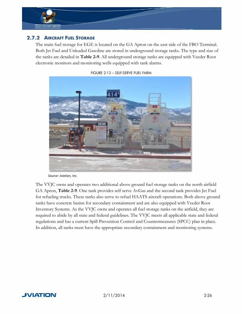
2.7.2 AIRCRAFT FUEL STORAGE The main fuel storage for EGE is located on the GA Apron on the east side of the FBO Terminal. Both Jet Fuel and Unleaded Gasoline are stored in underground storage tanks. The type and size of the tanks are detailed in Table 2-9. All underground storage tanks are equipped with Veeder Root electronic monitors and monitoring wells equipped with tank alarms.
FIGURE 2-13 – SELF-SERVE FUEL FARM
Source: Jviation, Inc.
The VVJC owns and operates two additional above ground fuel storage tanks on the north airfield GA Apron, Table 2-9. One tank provides self serve AvGas and the second tank provides Jet Fuel for refueling trucks. These tanks also serve to refuel HAATS aircraft operations. Both above ground tanks have concrete basins for secondary containment and are also equipped with Veeder Root Inventory Systems. As the VVJC owns and operates all fuel storage tanks on the airfield, they are required to abide by all state and federal guidelines. The VVJC meets all applicable state and federal regulations and has a current Spill Prevention Control and Countermeasures (SPCC) plan in place. In addition, all tanks must have the appropriate secondary containment and monitoring systems.
2/11/2014 2-26

TABLE 2-9 – FUEL STORAGE TANKS
Location Container Material Capacity (gal) Fuel Type South Fuel Farm Single Wall Steel 40,000 Jet South Fuel Farm Single Wall Steel 40,000 Jet South Fuel Farm Single Wall Steel 5,000 Jet South Fuel Farm Single Wall Steel 10,000 Unleaded South Fuel Farm Single Wall Steel 20,000 Jet South Fuel Farm Single Wall Steel 20,000 Jet South Fuel Farm Double Wall Fiberglass/Steel 30,000 Jet South Fuel Farm Double Wall Fiberglass/Steel 30,000 Jet North Fuel Farm Double Wall Steel 12,000 Jet North Fuel Farm Double Wall Steel 12,000 AvGas
Source: Vail Valley Jet Center
2.7.3 WEATHER OBSERVATION EQUIPMENT EGE has an Automated Weather Observing System (AWOS) located on the airfield. The AWOS is a Level III system, meaning it provides the following weather observations:
• Air Pressure • Wind Speed, Gusts, Direction • Variable Wind Direction • Temperature • Dew Point • Altimeter Setting • Density Altitude • Visibility • Variable Visibility • Precipitation • Cloud Ceiling Height • Sky Condition
Backup weather observation equipment was installed in August 2011. The equipment will be a Columbia Weather Systems Orion System and will provide the following observations:
• Air Pressure • Wind Speed • Temperature • Relative Humidity
2/11/2014 2-27

2.8 HIGH-ALTITUDE ARMY AVIATION TRAINING FACILITY (HAATS) HAATS is the primary training center for Army helicopter pilots conducting high-altitude flying. The facility simulates conditions commonly found in high-altitude mountainous environments. It is located on the north airfield and is positioned directly east of the ATCT and west of the GA hangars. The facility consists of a support building and a hangar for storage and maintenance of helicopters, as shown in Figure 2-14.
FIGURE 2-14 – HAATS FACILITY
Source: Jviation, Inc.
The facility is undergoing a major expansion as shown in Figure 2-15. The expansion is estimated to cost $40 million dollars and will add entirely new facilities adjacent to existing facilities, with the ability for future expansion.
2/11/2014 2-28

FIGURE 2-15 – HAATS EXPANSION
Source: Jacobs
2/11/2014 2-29

2.9 PARKING EGE has both short-term and long-term parking lots, as well as an overflow parking lot to accommodate the ski season peak traffic period. Short-term parking, Area 1 on Figure 2-16, is paved and in good condition. Long-term parking lots, Area 8 on Figure 2-16, are gravel and are generally in fair condition. The overflow parking lot, Area 9 on Figure 2-16, is asphalt millings that have been seal coated and striped. There are 554 short-term spaces and 464 long-term spaces with an additional 306 spaces in the overflow lot. There is no charge for parking in the short- or long-term parking lots and are on a first come, first serve basis. There is one paved permit parking lot, Area 4 on Figure 2-16, that has 48 spaces which are leased at six or twelve month intervals. The cost to park in the lot is $75 per month for a six month term, and $50 per month for a twelve month term.
There are additional parking areas dedicated for commercial vehicles, rental cars, and the FBO. The commercial lots, Area 3, are paved and in good condition with 95 spaces. The rental car ready return lots, Areas 2 & 5, are paved with a total of 403 available spaces. For the busy months, there is a rental car overflow lot, Area 10, which is paved with millings and also serves as a location to offload and stage vehicles from transport trucks. Finally, the VVJC has a paved and partially garaged parking lot, Area 7, which consists of 174 spaces for use by their customers.
2/11/2014 2-30

FIGURE 2-16 – AIRPORT PARKING
Source: Jviation, Inc.
2/11/2014 2-31
2.10 SURFACE TRANSPORTATION
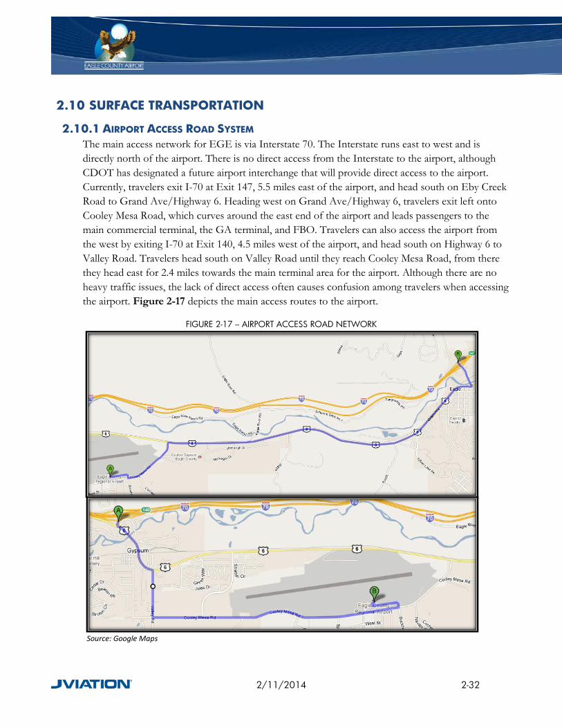
2.10.1 AIRPORT ACCESS ROAD SYSTEM The main access network for EGE is via Interstate 70. The Interstate runs east to west and is directly north of the airport. There is no direct access from the Interstate to the airport, although CDOT has designated a future airport interchange that will provide direct access to the airport. Currently, travelers exit I-70 at Exit 147, 5.5 miles east of the airport, and head south on Eby Creek Road to Grand Ave/Highway 6. Heading west on Grand Ave/Highway 6, travelers exit left onto Cooley Mesa Road, which curves around the east end of the airport and leads passengers to the main commercial terminal, the GA terminal, and FBO. Travelers can also access the airport from the west by exiting I-70 at Exit 140, 4.5 miles west of the airport, and head south on Highway 6 to Valley Road. Travelers head south on Valley Road until they reach Cooley Mesa Road, from there they head east for 2.4 miles towards the main terminal area for the airport. Although there are no heavy traffic issues, the lack of direct access often causes confusion among travelers when accessing the airport. Figure 2-17 depicts the main access routes to the airport.
FIGURE 2-17 – AIRPORT ACCESS ROAD NETWORK
Source: Google Maps
2/11/2014 2-32

2.10.2 CIRCULATION ROADS The main airport access road, Cooley Mesa Road, is a mainly two lane road, with portions that are 4 lanes, that comes off of Highway 6 and runs east to west on the south end of the airport property. On the west end of the airport, Jules Drive runs north to south and connects Highway 6 to Cooley Mesa Road. Further west from the airport, Valley Road connects Cooley Mesa Road to the Town of Gypsum and Interstate 70.
2.10.3 RAILROADS The closest railroad service is the Union Pacific Rail Line which passes within 120 feet of the northeast corner of the airport property. The rail line connects Denver to Salt Lake City, Utah and further west to California. The closest passenger rail station is in Glenwood Springs, 32 miles away by car. Presently, there are no stubs that extend onto airport property.
2.11 UTILITIES
2.11.1 WATER Water service is provided to EGE through the Town of Gypsum in the form of potable water and non-potable water. Potable water is used for drinking water and non-potable water is strictly used for irrigation. The water is owned by the Town of Gypsum and stored in various large water tanks throughout the town. Gypsum receives its water from three main sources: Mosher Springs, Gypsum Creek, and the Eagle River. Due to the high quality of water, the Town of Gypsum has to do very little in the way of treatment. The airport receives its water through several water mains located on the south side of the airfield to support the commercial terminal area and on the north airfield to support the HAATS and GA hangars.
2.11.2 SANITARY SEWER Sanitary services are provided through the Town of Gypsum, Public Works Department. Wastewater is collected and processed through the Town’s Aero Mod wastewater treatment plant. This plant can treat up to 960,000 gallons per day (GPD), and as of 2008, was operating at only 40% capacity.
2.11.3 COMMUNICATIONS Communications, to include telecommunication cables and pull boxes, are provided to the airport via Centurylink Communications. Centurylink is the primary communication provider for the airport and surrounding communities.
2.11.4 NATURAL GAS Natural Gas is provided to EGE and the surrounding area through Sourcegas. Sourcegas is responsible for acquisition and supply of natural gas to their customers within the service area.
2/11/2014 2-33

2.11.5 ELECTRICITY Electricity is provided to EGE through Holy Cross Energy. Holy Cross Energy is a not-for-profit utility that is member owned. Power is provided through long-term supply commitments with Public Service Company, a subsidiary of Xcel Energy. The power supply is a mix of 63% coal, 25% natural gas, and 12% Renewable Energy (Hydro, Solar, Wind, and Geothermal).
2.11.6 STORMWATER Stormwater runoff on airport property drains to the north and west into the Eagle River towards the Town of Gypsum. The stormwater system is composed of open channels and pipes directing the flow of water, and drainage basins to both collect runoff and increase water quality. The majority of the airport drains to the northwest, while the eastern edge of the airfield drains east before turning towards the north and the Eagle River. Figure 2-18 depicts the general direction of flow for stormwater departing EGE
2/11/2014 2-34

FIGURE 2-18 – STORMWATER DRAINAGE
Source: Jviation, Inc.
2/11/2014 2-35
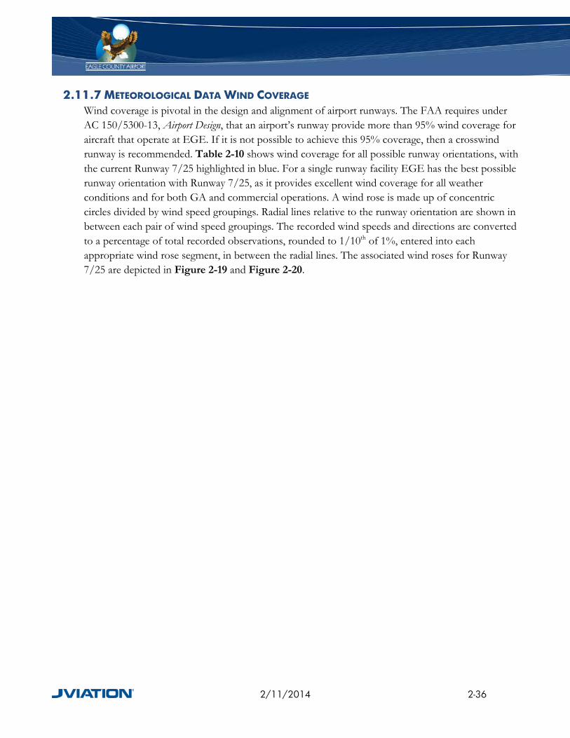
2.11.7 METEOROLOGICAL DATA WIND COVERAGE Wind coverage is pivotal in the design and alignment of airport runways. The FAA requires under AC 150/5300-13, Airport Design, that an airport’s runway provide more than 95% wind coverage for aircraft that operate at EGE. If it is not possible to achieve this 95% coverage, then a crosswind runway is recommended. Table 2-10 shows wind coverage for all possible runway orientations, with the current Runway 7/25 highlighted in blue. For a single runway facility EGE has the best possible runway orientation with Runway 7/25, as it provides excellent wind coverage for all weather conditions and for both GA and commercial operations. A wind rose is made up of concentric circles divided by wind speed groupings. Radial lines relative to the runway orientation are shown in between each pair of wind speed groupings. The recorded wind speeds and directions are converted to a percentage of total recorded observations, rounded to 1/10th of 1%, entered into each appropriate wind rose segment, in between the radial lines. The associated wind roses for Runway 7/25 are depicted in Figure 2-19 and Figure 2-20.
2/11/2014 2-36
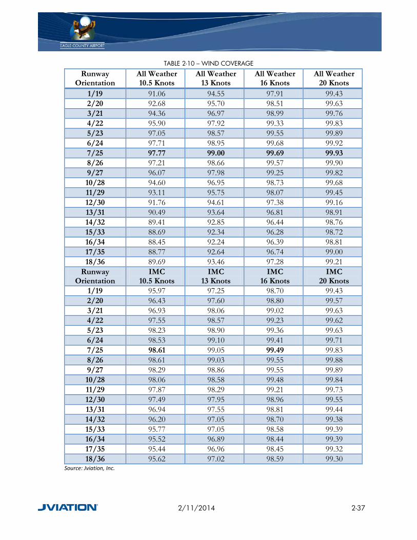
TABLE 2-10 – WIND COVERAGE
Runway Orientation
All Weather 10.5 Knots
All Weather 13 Knots
All Weather 16 Knots
All Weather 20 Knots
1/19 91.06 94.55 97.91 99.43 2/20 92.68 95.70 98.51 99.63 3/21 94.36 96.97 98.99 99.76 4/22 95.90 97.92 99.33 99.83 5/23 97.05 98.57 99.55 99.89 6/24 97.71 98.95 99.68 99.92 7/25 97.77 99.00 99.69 99.93 8/26 97.21 98.66 99.57 99.90 9/27 96.07 97.98 99.25 99.82 10/28 94.60 96.95 98.73 99.68 11/29 93.11 95.75 98.07 99.45 12/30 91.76 94.61 97.38 99.16 13/31 90.49 93.64 96.81 98.91 14/32 89.41 92.85 96.44 98.76 15/33 88.69 92.34 96.28 98.72 16/34 88.45 92.24 96.39 98.81 17/35 88.77 92.64 96.74 99.00 18/36 89.69 93.46 97.28 99.21
Runway Orientation
IMC 10.5 Knots
IMC 13 Knots
IMC 16 Knots
IMC 20 Knots
1/19 95.97 97.25 98.70 99.43 2/20 96.43 97.60 98.80 99.57 3/21 96.93 98.06 99.02 99.63 4/22 97.55 98.57 99.23 99.62 5/23 98.23 98.90 99.36 99.63 6/24 98.53 99.10 99.41 99.71 7/25 98.61 99.05 99.49 99.83 8/26 98.61 99.03 99.55 99.88 9/27 98.29 98.86 99.55 99.89 10/28 98.06 98.58 99.48 99.84 11/29 97.87 98.29 99.21 99.73 12/30 97.49 97.95 98.96 99.55 13/31 96.94 97.55 98.81 99.44 14/32 96.20 97.05 98.70 99.38 15/33 95.77 97.05 98.58 99.39 16/34 95.52 96.89 98.44 99.39 17/35 95.44 96.96 98.45 99.32 18/36 95.62 97.02 98.59 99.30
Source: Jviation, Inc.
2/11/2014 2-37

FIGURE 2-19 – IFR WINDROSE
Source: National Climatic Data Center, Historic Wind Data for EGE
2/11/2014 2-38

FIGURE 2-20 – ALL WEATHER WIND ROSE
Source: National Climatic Data Center, Historic Wind Data for EGE
2/11/2014 2-39

2.11.8 TEMPERATURE As reported by the Western Regional Climate Center (WRCC) through the EGE AWOS, the airport reference temperature, which is defined as the mean maximum temperature of the hottest month of the year, is 85.5 degrees Fahrenheit (°F) and occurs in the month of July. EGE experiences an average of 13 days per year where the temperature is above 90°F. The average temperature in January is 19.0°F and the average temperature in July is 65.5°F.
2.11.9 PRECIPITATION EGE’s total annual precipitation average is 10.88 inches. This average includes 35 days in which there is precipitation of 0.10 inches and greater. The average annual snowfall for EGE is 48 inches.
2.11.10 INSTRUMENT METEOROLOGICAL CONDITIONS (IMC) IMC exists when cloud ceilings are less than 1,000 feet above ground and/or visibility is less than three miles. In periods of IMC, aircraft are required to follow Instrument Flight Rules (IFR). IMC conditions exist at EGE 2.42% of the time, with the majority occurring in the months of December, January, and February, as shown in Table 2-11.
TABLE 2-11 – IMC PERCENTAGE
Month IMC% January 3.70
February 3.85 March 3.10 April 2.40 May 1.70 June 0.60 July 0.49
August 0.73 September 0.93 October 2.18
November 2.86 December 4.49
Source: National Climatic Data Center, Historic Wind Data for EGE
2.12 AIRPORT EQUIPMENT
2.12.1 ARFF EQUIPMENT EGE is certificated by the FAA to serve certain air carrier operations, under 14 CFR Part 139, Certification of Airports. Part 139 requires airport operators comply with safety and emergency response requirements, including aircraft rescue and fire fighting (ARFF) services. ARFF requirements are grouped into indexes and the type of ARFF services required for each index
2/11/2014 2-40

depends on the type of air carrier aircraft serving the airport. As the largest air carrier aircraft the Airport services is less 159 feet long, FAA requires the Airport to comply with Index C ARFF requirements.
To comply with ARFF requirements, EGE has four active ARFF response vehicles for aircraft emergencies. These include one 2006 Oshkosh Striker 3000, one 1988 Oshkosh T-1500, one 1993 Oshkosh T-1500, and one 2004 Tote ARFF foam trailer. EGE is currently in the process of procuring an additional ARFF response vehicle, having just recently awarded the bid to Oshkosh for a Striker 1500-gallon response vehicle.
2.12.2 SNOW REMOVAL EQUIPMENT (SRE) Currently, the airport owns and operates 20 pieces of equipment for snow removal. The airport has equipment for both landside snow removal and for airfield snow removal operations. This equipment is adequate for snow removal across the airport; however some of the equipment is nearing the end of its life-cycle and will need to be replaced. The airport staff has been complimented by several airport tenants and users on how quickly the airfield complex is cleared of snow debris. All SRE currently utilized by EGE is listed in Table 2-12.
TABLE 2-12 – SNOW REMOVAL EQUIPMENT Year Make Model Type 2009 Ford 1 Ton Plow 2006 Oshkosh HB Series Broom 2005 Stewart & Stevenson Prototype Runway Broom Broom 2001 Ford ¾ Ton Plow 2001 Dodge ¾ Ton Plow 1999 Oshkosh H-Series Broom 1998 Oshkosh P-Series Plow 1998 Oshkosh H-Series Broom 1998 Stewart & Stevenson SST300H Broom 1998 Stewart & Stevenson RSS1000-COP Blower 1979 John Deere Tractor with Broom Broom 1995 Kodiak Northwest Snowblower Blower 1994 Kodiak Northwest Snowblower Blower 1993 Oshkosh H-Series Broom 1992 Oshkosh H-Series Blower 1992 Oshkosh H-Series Broom 1991 Oshkosh H-Series Broom 1989 International Tandem Dump Truck Plow 1972 Oshkosh UNK Plow 1968 Snowblast Snowblower Blower
Source: Eagle County Regional Airport
2/11/2014 2-41

2.13 DEICING Aircraft deicing occurs on the Commercial Apron at designated Spots 1 and 2 and on the east end of the GA Apron. Containment of the glycol is achieved through the use of a trench drain located on the north and west edges of the deice spots, as depicted in Figure 2-21. Glycol is then collected in recovery tanks for eventual disposal.
2/11/2014 2-42
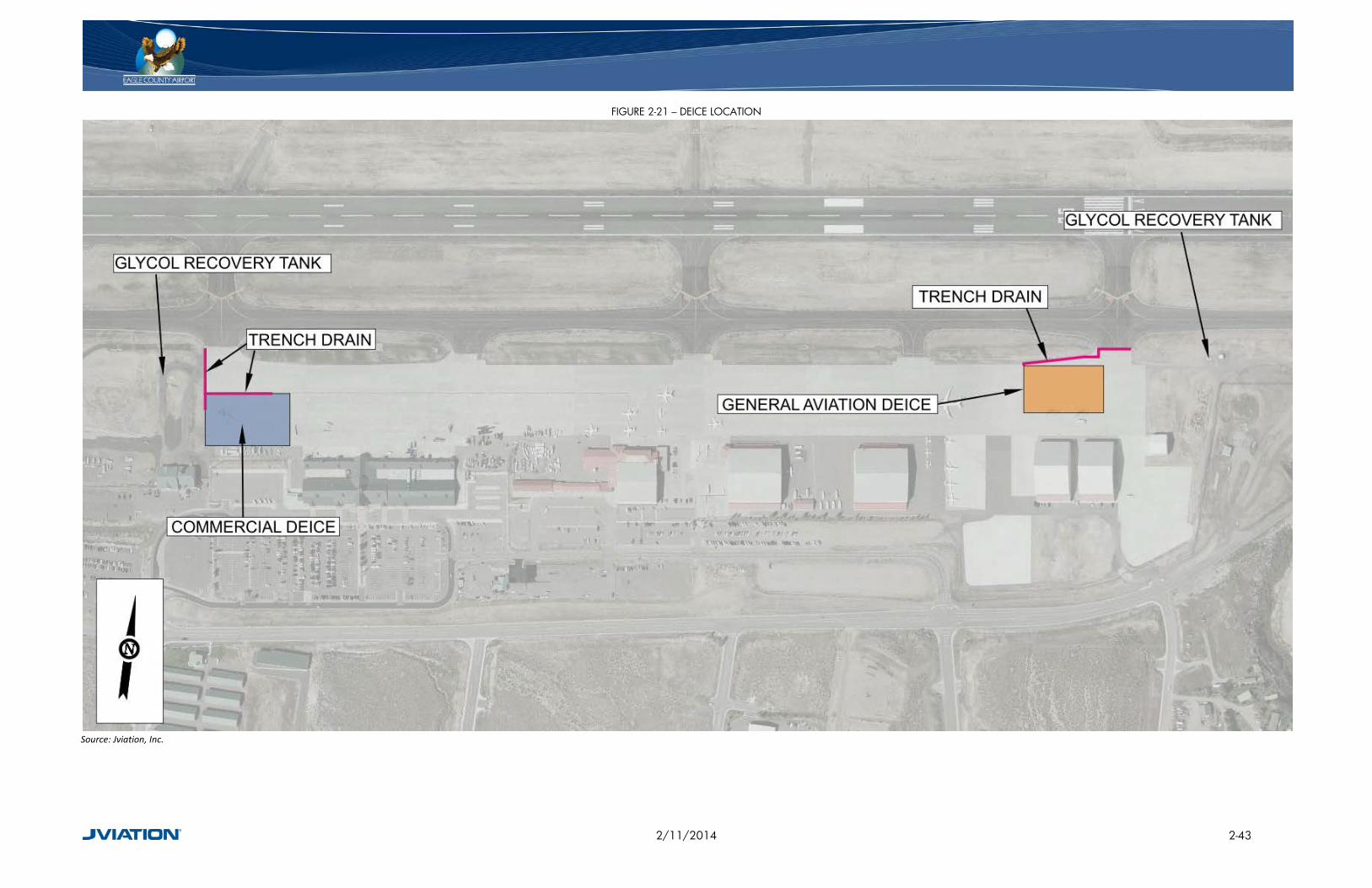
FIGURE 2-21 – DEICE LOCATION
Source: Jviation, Inc.
2/11/2014 2-43

2.13.1 AIRCRAFT FUELING EQUIPMENT The VVJC owns and operates all the refueling trucks and refuels all aircraft on the airport. The VVJC operates 11 refueling trucks which are described in Table 2-13. The VVJC also operates one defuel truck, used to remove gas from an aircraft, and one truck for unleaded vehicle gas.
TABLE 2-13 – VVJC AIRCRAFT FUELING EQUIPMENT Year Make Model Fuel Type Capacity (gal) 2010 International Garsite Jet A 5000 2010 International Garsite Jet A 5000 2010 International Garsite Jet A 5000 2010 International Garsite Jet A 5000 2010 International Garsite Jet A 5000 2001 International Determan Jet A 5000 1998 International Determan Jet A 5000 1998 Freightliner Determan Jet A 5000 1998 Isuzu Dukes 100LL 750 1997 Freightliner Determan Jet A 5000 1996 Freightliner Determan Jet A 5000 1996 Freightliner Determan Jet A 5000 1986 International Wilco Defuel 5000 1984 Ford Bosserman Mogas 2200
Source: Vail Valley Jet Center
2.13.2 AIRPORT CERTIFICATION As discussed above, the FAA issues airport operating certificates to airport operators serving certain air carrier operations under 14CFR, Part 139, Certification of Airports. To obtain a certificate, an airport must agree to certain operational and safety standards and provide for emergency services, such as ARFF services. These requirements vary depending on the size of the airport and types of flights available.
Under Part 139, FAA certificates EGE as a Class I Airport, as it serves scheduled air carrier service aircraft with greater than 30 passenger seats. As a Class I airport, EGE is required to comply with all Part 139 requirements. The specifics of how EGE complies with Part 139 requirements are detailed in its FAA-approved Airport Certification Manual.
The FAA ensures airports comply with all Part 139 requirements through annual airport inspections. EGE is in compliance with Part 139, and had its last annual inspection on March 27, 2013. In the closeout letter from this inspection, FAA recommended that Taxiways B, B3, and B4 be converted to a movement area. These are currently considered areas that do not require permission from Air Traffic Control prior to movement. If converted to a movement area, aircraft would be required to contact the control tower prior to taxiing and would require EGE to revise its Letter of Agreement with the tower.
2/11/2014 2-44

2.13.3 SECURITY In addition to passenger screening, the County is obligated to have and implement a security program in accordance with 49 CFR, Part 1542, Airport Security. Security items the airport must manage include:
• Security of the secured area
• Security of the Air Operations Area (AOA)
• Security of the Security Identification Display Area (SIDA)
• Access control systems
• Fingerprint-based criminal history records checks (CHRC)
• Identification systems
• Training
• Law enforcement personnel
• Supplementing law enforcement personnel
• Records of law enforcement response Similar to complying with Part 139 requirements, EGE must takespecific measures to ensure all required TSA regulations are satisfied and are inspected regularly to ensure compliance. To comply with Part 1542, the entire airfield is secured by a 12 foot tall perimeter security fence. Additionally, airfield access gates and doors are secured by a card reader system that monitors and records all openings.
2.14 AIRPORT PROPERTY The airport property is composed of approximately 632 acres. The original 111 acres were purchased in 1943, and the remaining 554 acres were purchased between 1946 and 2007. FAA grant funding was used to purchase the majority (68%) of the land (which obligates the County to Federal grant assurances for in perpetuity). The remaining 32% of the land were purchased independently by Eagle County. The land depicted as the airport on the Exhibit “A” Property Map must be used in accordance with the map and with the Airport Layout Plan. Property that is designated for aeronautical use cannot be used for non-aeronautical purposes except under limited circumstances or with FAA approval. Figure 2-22 depicts the current airport property broken out by funding source.
It is important to note that all property is contiguous, with the exception of a parcel on the east end of the airport that is across Cooley Mesa Road to the south, depicted in Figure 2-23. This 22 acre parcel was purchased with FAA grant funds for runway approach protection and is therefore currently restricted to aeronautical uses.
2/11/2014 2-45
FIGURE 2-22 – CURRENT AIRPORT PROPERTY
Source: Jviation, Inc.
2/11/2014 2-46
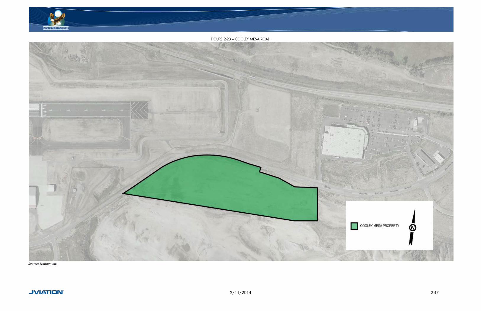
FIGURE 2-23 – COOLEY MESA ROAD
Source: Jviation, Inc.
2/11/2014 2-47

2.15 REGIONAL SETTING AND LAND USE EGE is located south of Interstate 70, 100 miles west of Denver, approximately one mile east of Gypsum and five miles west of Eagle. In 2009, airport land was annexed by the Town of Gypsum from the County. The annexation was deemed necessary in order for the Town of Gypsum to provide water and sewer services to the airport. However, Eagle County maintains exclusive control and governance over the aeronautical activities13 and uses at the airport through an intergovernmental agreement. Gypsum regulates non-aeronautical activities and uses to include, all activities uses and improvements at the airport that are not aeronautical activities and uses.
The land surrounding the airport is primarily owned by Gypsum and Eagle County. As depicted in Figure 2-24, the land to the east, south, and west of the airport is owned by Gypsum and is zoned as Agricultural (AG), Planned Unit Development (PUD), Light Industrial (LI), and Commercial Professional District (CP). AG, LI, and CP are defined by the Gypsum Municipal Code, Title 18 as:
• The Agricultural District is an ultra low-density district intended for the pursuit of farm activities and limited animal raising and grazing activities or for transitional status. This zone district is characterized by growing crops and raising livestock. It is intended to maintain the rural character of areas at the periphery of the Town, while allowing some appropriate residential development.
• The Planned Unit Development includes usable, functional open space for the mutual benefit of the entire tract and is designed to provide variety and diversity through the variation of normal zoning and subdivision standards so maximum long-range benefits can be gained, and the unique features of the development or site preserved and enhanced while still being in harmony with the surrounding neighborhood.
• The Light Industrial District is intended to provide locations for a variety of workplaces including light industrial uses, service businesses, research and development offices and institutions. This zone district is intended to encourage the development of planned office and business parks; to promote excellence in the design and construction of buildings, outdoor spaces, transportation facilities and streetscapes.
• The Commercial/Professional District identifies lands located along both sides of Highway 6 and along Cooley Mesa Road that are suitable for commercial development. The Commercial/Professional District is intended to provide for the location of auto-oriented and auto-dependent uses and/or uses which provide a wide range of general retail goods and services for residents of the local community and the region, as well as businesses and highway users, primarily inside of enclosed structures.
The land north of the airport is zoned as Resource (R) by Eagle County as depicted in Figure 2-25. Resource zone district’s purpose is defined by Article 3, Eagle County Zoning as “maintaining the open rural character of Eagle County and to protect and enhance the appropriate use of natural resources and agricultural uses in the County including water, minerals, fiber and open
13 Aeronautical activities and uses include any activity or improvement that contributes to, or is related to the safety or operation of aircraft.
2/11/2014 2-48

land.” By ensuring the surrounding land is preserved as it currently exists, this results in a restriction of development that does not introduce land uses incompatible with aeronautical activities.
FIGURE 2-24 – TOWN OF GYPSUM ZONING
Source: Town of Gypsum Website, http://www.townofgypsum.com/DocumentView.aspx?DID=2264
2/11/2014 2-49

FIGURE 2-25 – EAGLE COUNTY ZONING
Source: Eagle County Government, GIS Viewer, 2005
2/11/2014 2-50

2.16 COMMUNITY PLANNING INITIATIVES Eagle County has completed and continues to work on an extensive number of planning initiatives. The County in conjunction with many stakeholders, including state and federal land management agencies, neighboring jurisdictions, community organizations, and community citizens, are continuously working on various master plans. These master plans offer guidance for the County and evaluate present conditions in relation to the visions for the future. In addition to this Airport Master Plan, the County has completed the Eagle County Comprehensive House Plan, the Eagle River Watershed Plan, the ECO Trails Plan, the Open Space Master Plan, and most significantly, the Eagle County Comprehensive Master Plan (ECCMP).
The ECCMP14 was adopted in 2005 by the Eagle County Planning Commission. The purpose of the ECCMP was to establish a vision for Eagle County in the present and into the future. The ECCMP defined issues, set goals, and developed plans to achieve the goals. Topics covered throughout the plan include: setting policies and direction for the use, development, and protection of land and setting of goals for the social, economic, and natural environment of the County. Specifically, the Plan consists of background information, baseline trends and characteristics, the Eagle County Planning Policy Framework, Area Plans, and various supporting documents.
In addition to the planning initiatives of Eagle County, Gypsum has also developed the Eagle River Area Plan (ERAP). The ERAP will ultimately result in a land use concept plan to meet future goals of the communities along the five mile stretch of Eagle River between Highway 6 and I-70. The ERAP will promote environmental, social, and economic sustainability for Gypsum and the surrounding area.
The Town of Eagle is the nearest neighbor of the airport after Gypsum and is the county seat for Eagle County. Eagle has developed the Eagle Area Community Plan (EACP) through their planning initiatives. The original EACP was completed in 1996, and began being updated in 2007. The EACP is a cooperative planning effort between the Town of Eagle and Eagle County. Growth in the community spurred the need for revisions to the EACP, to include new demographic information, new visions, and a summary of community input, goals, policies, and strategies. The EACP is currently being reviewed before adoption of the latest revisions.
2.17 ENVIRONMENTAL AND SUSTAINABILITY
2.17.1 AIR QUALITY Air quality analysis for federally funded projects must be prepared in accordance with applicable air quality statutes and regulations that include the Clean Air Act of 197015, the 1977 Clean Air Act
14 Eagle County Community Development, Eagle County Comprehensive Plan, Adopted 2005 15 U.S. Code. The Clean Air Act of 1970. U.S. Congress, Public Law 91-604, 42 U.S.C. §7401
2/11/2014 2-51
Amendments16, the 1990 Clean Air Act Amendments17, and the National Ambient Air Quality Standards18 (NAAQS). In particular, the air pollutants of concern in the assessment of impacts from airport-related sources include six “criteria pollutants”; carbon monoxide (CO), lead (Pb), nitrogen dioxide (NO2), ozone (O3), particulate matter (PM-10 and PM-2.5), and sulfur dioxide (SO2).
The airport is located in Eagle County, which is designated by the U.S. Environmental Protection Agency as being in attainment status for all parts of the county in all criteria19.
2.17.2 DEPARTMENT OF TRANSPORTATION ACT: SECTION 4(F) The Department of Transportation (DOT) Act, Section 4(f)20 provides that the “Secretary of Transportation will not approve any program or project that requires the use of any publicly owned land from a public park, recreation area, or wildlife and waterfowl refuge of national, state, or local significance or land from an historic site of national, state, or local significance unless there is no feasible or prudent alternative and the use of such land includes all possible planning to minimize harm resulting from the use”.
An analysis of potential DOT 4(f) properties in Eagle found there are 17 community parks and recreational areas (see Table 2-14). Quail Run in Gypsum is located approximately 0.3 miles northwest of the airport, and is the nearest potential DOT 4(f) property to the airport. Additionally, Gypsum Estates Park, Gypsum Sports Complex, Town Hall Park (Gypsum), Recreation Center (Gypsum), and Lundgren Theater (Gypsum) are all located within one mile of the airport.
16 U.S. Code. The 1977 Clean Air Act Amendments, U.S. Congress, Public Law 95-95, 42 U.S.C. §7401 17 U.S. Code. The 1990 Clean Air Act Amendments, U.S. Congress, Public Law 101-549, 42 U.S.C. §7401 18 40 CFR Part 50, Section 121, National Ambient Air Quality Standard 19 U.S. Environmental Protection Agency, Green Book – Nonattainment Status for Each County by Year, 2012 20 U.S. Department of Transportation Act, section 4(f), recodified and renumbered as § 303(c) of 49 U.S.C.
2/11/2014 2-52

TABLE 2-14 – POTENTIAL DOT 4(F) PROPERTIES Property Name Address Town Type Distance
to Airport 1 Quail Run 105&107 Quail Circle Gypsum Park 0.3 miles 2 Gypsum Estates 832 Green Way Gypsum Park 0.5 miles 3 Gypsum Sports
Complex 3295 Cooley Mesa Rd. Gypsum Park 0.7 miles
4 Town Hall Park 50 Lundgren Boulevard Gypsum Park 0.8 miles 5 Recreation Center 52 Lundgren Boulevard Gypsum Rec Center 0.8 miles 6 Lundgren Theater 52 Lundgren Boulevard Gypsum Theater 0.8 miles 7 Second Street Park 505 Second Street Gypsum Park 1 mile 8 Estes Lane Park 200 Estes Lane Gypsum Park 1 mile 9 Sylvan Lake State Park 10200 Brush Creek Road Eagle Park 12 miles 10 Eagle River Estates 437 Porphyry Road Gypsum Park 2 miles 11 Eagle Fairgrounds
Sports Complex 1400 Fairgrounds Road Eagle Fairgrounds 3 miles
12 Brush Creek Pavilion S. of Capital St. and Brush Creek Rd. Eagle Park 4 miles 13 Terrace Brush Creek Terrace Eagle Park 4 miles 14 Eagle Town Park Washington St. and W 6th St. Eagle Park 4 miles 15 Chambers Park Chambers Ave. and Eby Creek Rd. Eagle Park 4 miles 16 The Bluffs 3rd St. and Mill Rd. Eagle Park 5 miles 17 Eagle Pool and Ice
Rink 1700 Bull Pasture Road Eagle Park 5 miles
Source: Town of Eagle and Gypsum Websites: http://www.townofgypsum.com and http://www.townofeagle.org
2.17.3 FARMLANDS The Farmland Protection Policy Act (FPPA) regulates federal actions that may impact or convert farmland to a non-agricultural use. FPPA defines farmland as “prime or unique land as determined by the participating state or unit of local government and considered to be of statewide or local importance.”
Eagle County is primarily Federal land, or “other” lands, as depicted by Figure 2-26. Neither of these land types are considered to have high quality farmland or relatively large amounts of prime or unique farmland. Fish, Wildlife and Plants requirements have been set forth by The Endangered Species Act21, The Sikes Act22, The Fish and Wildlife Coordination Act23, The Fish and Wildlife Conservation Act24, and then Migratory Bird Treaty Act25, for the protection of fish, wildlife, and plants of local and national significance.
21 Endangered Species Act of 1973, U.S. Congress, Public Law 93-205, 16 U.S.C §1531-1544 22 Sikes Act, Amendments of 1974, U.S. Congress, Public Law 93-452 23 Fish and Wildlife Coordination Act of 1958, U.S. Congress, Public Law 85-624, 16 U.S.C §661-666c 24 Fish and Wildlife Conservation Act of 1980, U.S. Congress, Public Law 96-366, 16 U.S.C §2901-2912 25 Migratory Bird Treaty Act of 1981, 16 U.S.C §703-712
2/11/2014 2-53

Eagle County has several species listed by the U.S. Fish and Wildlife Service as being threatened, endangered, or candidates to be listed as threatened or endangered as depicted in Table 2-15.
TABLE 2-15 – THREATENED AND ENDANGERED SPECIES, EAGLE COUNTY Species Scientific Name Status
Greater sage-grouse (Centrocercus urophasianus Candidate Yellow-billed Cuckoo (Coccyzus americanus) Candidate Mexican spotted owl (Strix occidentalis lucida) Threatened
Bonytail chub Gila elegans Endangered Colorado pikeminnow Ptychocheilus lucius Endangered
Greenback Cutthroat trout (Oncorhynchus clarki stomias) Threatened Humpback chub Gila cypha Endangered Razorback sucker Xyrauchen texanus Endangered
Penland Alpine Fen mustard Eutrema penlandii Threatened Ute ladies’-tresses (Spiranthes diluvialis) Threatened
Uncompahgre fritillary butterfly (Boloria acrocnema) Endangered Canada Lynx (Lynx canadensis) Threatened
North American wolverine (Gulo gulo luscus) Candidate Source: U.S. Fish and Wildlife Service – Species Reports, Eagle CO, May 20, 2012
2/11/2014 2-54
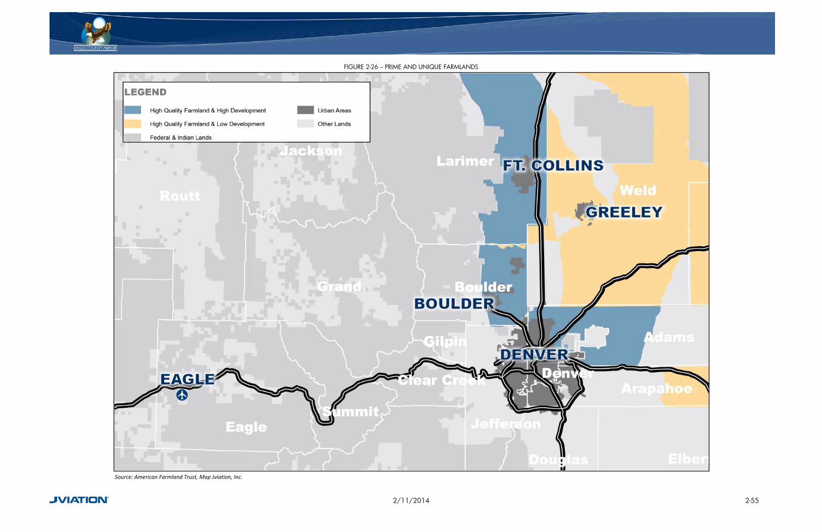
FIGURE 2-26 – PRIME AND UNIQUE FARMLANDS
Source: American Farmland Trust, Map Jviation, Inc.
2/11/2014 2-55

2.17.4 FLOODPLAINS Executive Order 11988, Floodplain Management26, directs federal agencies to “avoid to the extent possible the long and short-term adverse impacts associated with the occupancy and modification of floodplains and to avoid direct and indirect support of floodplain development wherever there is a practicable alternative.”
An examination of the Flood Insurance Rate Maps (FIRM) for Eagle County and the region immediately surrounding the airport found no flood zones located within airport property. The nearest flood zone is north of the airport by approximately a half a mile, as depicted in Figure 2-27.
2.17.5 HAZARDOUS MATERIALS, POLLUTION PREVENTION, AND SOLID WASTE The Resource Conservation and Recovery Act (RCRA)27, Comprehensive Environmental Response, Compensations, and Liability Act (CERCLA)28, Superfund Amendments and Reauthorization Act (Superfund)29, and the Community Environmental Response Facilitation Act (CERFA)30 are the four predominant laws regulating actions related to the use, storage, transportation, or disposal of hazardous materials, chemicals, substances, and wastes. Federal actions that pertain to the funding or approval of airport projects require the analysis of the potential for environmental impacts per the regulating laws. Furthermore, property listed or considered for the National Priority List (NPL) should be evaluated in relation to the airport’s location. Eagle County has one NPL listed site; the Eagle Mine is located 26 miles east of the airport in Minturn/Red Cliff, CO.
26 Executive Order 11988, Floodplain Management, 1977 27 U.S. Code, 1976, Resource Conservation and Recovery Act, 42 USC, §6901 28 U.S. Code 1980, Comprehensive Environmental Response, Compensation and Liability Act, 42 USC, §9601-9628 29 U.S. Code 1986, Superfund Amendments and Reauthorization Act, 42 USC 30 U.S. Code 1992, Community Environmental Response Facilitation Act, Public Law 102-426
2/11/2014 2-56

FIGURE 2-27 – FLOOD INSURANCE RATE MAP
Source: National Flood Insurance Program, 2011
2/11/2014 2-57
2.17.6 HISTORICAL, ARCHITECTURAL, ARCHAEOLOGICAL, AND CULTURAL RESOURCES The National Historic Preservation Act31 and the Archaeological and Historical Preservation Act32 regulate the preservation of historical, architectural, archaeological and cultural resources. Federal actions and undertakings are required to evaluate the impact on these resources.
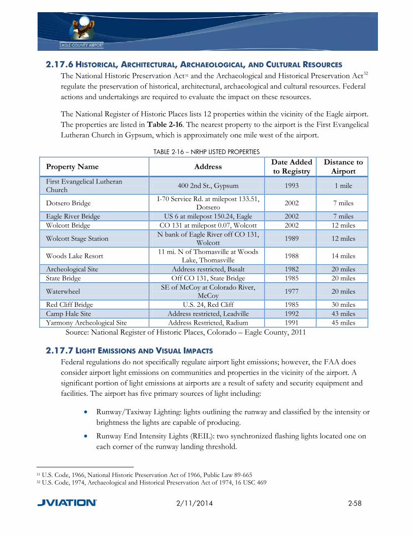
The National Register of Historic Places lists 12 properties within the vicinity of the Eagle airport. The properties are listed in Table 2-16. The nearest property to the airport is the First Evangelical Lutheran Church in Gypsum, which is approximately one mile west of the airport.
TABLE 2-16 – NRHP LISTED PROPERTIES
Property Name Address Date Added to Registry
Distance to Airport
First Evangelical Lutheran Church 400 2nd St., Gypsum 1993 1 mile
Dotsero Bridge I-70 Service Rd. at milepost 133.51, Dotsero 2002 7 miles
Eagle River Bridge US 6 at milepost 150.24, Eagle 2002 7 miles Wolcott Bridge CO 131 at milepost 0.07, Wolcott 2002 12 miles
Wolcott Stage Station N bank of Eagle River off CO 131, Wolcott 1989 12 miles
Woods Lake Resort 11 mi. N of Thomasville at Woods Lake, Thomasville 1988 14 miles
Archeological Site Address restricted, Basalt 1982 20 miles State Bridge Off CO 131, State Bridge 1985 20 miles
Waterwheel SE of McCoy at Colorado River, McCoy 1977 20 miles
Red Cliff Bridge U.S. 24, Red Cliff 1985 30 miles Camp Hale Site Address restricted, Leadville 1992 43 miles Yarmony Archeological Site Address Restricted, Radium 1991 45 miles
Source: National Register of Historic Places, Colorado – Eagle County, 2011
2.17.7 LIGHT EMISSIONS AND VISUAL IMPACTS Federal regulations do not specifically regulate airport light emissions; however, the FAA does consider airport light emissions on communities and properties in the vicinity of the airport. A significant portion of light emissions at airports are a result of safety and security equipment and facilities. The airport has five primary sources of light including:
• Runway/Taxiway Lighting: lights outlining the runway and classified by the intensity or brightness the lights are capable of producing.
• Runway End Intensity Lights (REIL): two synchronized flashing lights located one on each corner of the runway landing threshold.
31 U.S. Code, 1966, National Historic Preservation Act of 1966, Public Law 89-665 32 U.S. Code, 1974, Archaeological and Historical Preservation Act of 1974, 16 USC 469
2/11/2014 2-58
• Precision Approach Path Indicator (PAPI): a row of lights that provide visual glide slope guidance in non-precision approaches.
• Medium Intensity Approach Lighting System with Runway Alignment Indicator Lights (MALSR): a combination of threshold lamps, steady burning light bars and flashers (that provide visual information to pilots on runway alignment), height perception, role guidance, and horizontal references.
• Airport beacon: a rotating light used to locate the airport. All five sources of light aid in the safety of operations at the airport and most likely produce an insignificant amount of light on the surrounding communities.
2.17.8 NOISE Aircraft noise can limit airport growth, affect land use decisions in areas surrounding an airport, and reduce community acceptance and support for airports. Airport operators have limited authority to restrict aircraft operations to reduce noise, but can influence noise exposure by, for example, promoting voluntary noise abatement measures, encouraging and supporting compatible land uses, and controlling airport capital development. Both the airport operator and the FAA examine the consequences of various actions on cumulative noise exposure, including during environmental review conducted in accordance with the National Environmental Policy Act. Noise issues and abatement procedures are covered below.
2.17.8.1 Noise Abatement Procedures Currently, there are no noise abatement procedures at EGE. This is due in part to Federal limitations on such procedures, as well as the constraints placed on the airspace from the mountainous terrain that surrounds all quadrants. The terrain greatly limits the routes aviation traffic can fly when departing the airport. It should also be noted that once aircraft depart EGE they are quickly above unpopulated terrain where noise is less of an impact.
2.17.9 WATER QUALITY The Clean Water Act33 provides the federal government the “authority to establish water quality standards, control discharges, develop waste treatment management plans and practices, prevent or minimize the loss of wetlands, location with regard to an aquifer or sensitive ecological area such as a wetland area, and regulate other issues concerning water quality.”
The major watersheds in Eagle County are the Colorado, Roaring Fork, and Eagle Rivers. The Eagle River Watershed Plan (Plan) describes the county’s proposed idea for protecting and improving water quantity, water quality, wildlife habitat and recreational opportunities. The Plan also encourages compatible land use practices.
33 U.S. Code, 1977 The Clean Water Act, 33 U.S.C. §1251-1387
2/11/2014 2-59
Water quality and public water suppliers in Eagle County are regulated and inspected by the Colorado Water Quality Control Division (Division). The Division publishes their findings in the Consumer Confidence Reports and distributes annual compliance with the Safe Drinking Water Act.
2.17.10 WETLANDS Executive Order 11990, Protection of Wetlands, defines wetlands as “those areas that are inundated by surface or groundwater with a frequency sufficient to support and under normal circumstances does or would support a prevalence of vegetative or aquatic life that requires saturated or seasonally saturated soil conditions for growth and reproduction.” Federal agencies are required to minimize the destruction, loss, or degradation of wetlands.
An examination of the National Wetlands Inventory, as depicted in Figure 2-28 illustrates that there is wetlands potential within the airport boundary. Any future capital project potentially affecting wetlands would require detailed examination and, if necessary, approval of the U.S. Army Corps of Engineers.
2.17.11 WILD AND SCENIC RIVERS The Wild and Scenic Rivers Act of 1968, as amended34, describes those river segments designated as, or eligible to be included in, the Wild and Scenic Rivers System. Impacts should be avoided or minimized to the extent possible when the rivers or river segments that fall under this Act may be affected by a proposed action. In addition, the President’s 1979 Environmental Message Directive on Wild and Scenic Rivers35, directs Federal agencies to avoid or mitigate adverse effects on rivers identified in the Nationwide Rivers Inventory as having potential for designation under the Wild and Scenic Rivers Act.
The Cache La Poudre River is the only nationally designated Wild and Scenic River in Colorado. The River is approximately 100 miles to the northeast of the airport.
34 U.S. Code, The Wild and Scenic Rivers Act of 1968, 16 USC 1271-1287, 1977 35 Office of Environmental Policy, 1979, Policy Guidelines for Wild and Scenic Rivers, 1980
2/11/2014 2-60

FIGURE 2-28 – WETLANDS INVENTORY MAP
*This map is for general reference only. The US Fish and Wildlife Service is not responsible for the accuracy of the base data shown on this map. All wetlands related data should be used in accordance with the layer metadata found on this Wetlands Mapper web site.
2/11/2014 2-61

2.17.12 SUSTAINABILITY Sustainability can be defined as “the ability to meet the needs of the present without compromising the ability of future generations to meet their own needs”. For the purpose of Master Plans, sustainability is the ideas, actions and processes implemented to reduce the overall impact the airport has on the local, regional, and total environment. The airport can reduce its impact on the environment by using water, energy, land, and materials efficiently, protecting the health and improving the productivity of the employees and passengers, and by reducing waste and pollution. Eagle County has implemented numerous sustainable initiatives. The airport is participating in the programs to the extent possible, and through this Master Plan will be developing their own sustainable goals and programs (see Section 6.2).
2.17.12.1 Local Sustainability Initiatives Eagle County promotes and participates in a variety of sustainable initiatives both on a local and state level. Sustainability efforts to improve the local environment include reducing greenhouse gas emissions; pollution prevention; promoting clean, renewable energy; and conducting periodic reviews of the policies and environmental regulations36. The predominant sustainable initiatives for Eagle County are divided into four basic categories: the natural environment, the built environment, conservation, and transportation.
2.17.12.2 Natural Environment The preservation of the natural environment through open space has been a success in Eagle County as nearly 80% of the land is owned by state, federal and local governments. The open space is preserved through public lands; privately held open space within development areas; land trusts; and the County’s open space program37.
2.17.12.3 Built Environment Eagle County strives to improve the built environment of the County through the use of Energy Smart, Eco-Build, rebates and incentives, and sustainable community index. Energy Smart is a Department of Energy funded program created to help communities identify and address barriers to making energy efficient improvements. Energy Smart includes an outreach campaign, energy resource centers, and financial solutions to promote and help increase the number of energy efficient projects in the community.
Eco-Build is a set of building regulations that promote energy efficient, cost effective, durable, and material efficient buildings, both in design and construction. The regulations apply to new construction, additions/reconstruction (if over 50% of the existing floor area), and some exterior projects. The County’s rebates and incentive programs also encourage sustainable building projects and include rebates and incentives for solar Photovoltaic (PV),
36 Eagle County, http://www.eaglecounty.us/sustainable/,2011 37 Ibid
2/11/2014 2-62

solar thermal, source gas insulation, and Xcel Energy insulation. The Sustainable Community Index (SCI) is a review tool adopted by Eagle County used to analyze how new developments may contribute to the sustainability of the community. 38 The SCI is required for new development proposals such as PUDs, zone changes, final plats, subdivisions, and special use permits that are to be reviewed by the BOCC.
2.17.12.4 Conservation Eagle County’s conservation initiative includes a significant recycling program. The Recycled Materials Recovery Facility (MRF) opened in 2010 and is designed to process recycled materials collected throughout the County. The MRF greatly increases the ability of the County to recycle as the distance to other recycling markets is lengthy. The MRF recycles glass, steel/tin, #1 PET, #3 HDPE, potentially #3-7 plastic containers, aluminum beverage containers, newspaper, and corrugated cardboard. In addition to the MRF, Eagle County has recycling locations in Vail, Red Cliff, Avon, Edwards, Eagle and Gypsum. EGE participates in the recycling program, and recycles cardboard, glass, plastic, aluminum, and paper from the terminal.
For wastes that cannot be normally recycled, Eagle County has one landfill that accepts non-hazardous residential and commercial solid waste. Hazardous waste can be disposed of at the Eagle County Household Hazardous Waste Facility, which accepts common household hazard waste and electronic waste.
2.17.12.5 Transportation Eagle County is participating in a valley wide Transportation Collaborative (Collaborative), which is being used to identify current and future transportation issues. The Collaborative has reviewed the existing transportation services; completed the Eagle/Gypsum/Eagle County financial analysis for transportation improvements; investigation/discussion of potential transportation infrastructure financing opportunities; and offered assistance to the I-70 Coalition study regarding land use patterns and potential transit station locations. The Collaborative in conjunction with the ECO Transit, a public bus system, and the ECO Trails, a multi-use trail system, and Eagle County is progressively working towards a multitude of sustainable transportation options for the local communities.
38 Eagle County, http://www.eaglecounty.us/sustainable/,2011
2/11/2014 2-63