
2.0 EXISTING CONDITIONS ANALYSIS - planning.dc.gov · 2.0 EXISTING CONDITIONS ANALYSIS. 10 This...
32
RIGGS ROAD & SOUTH DAKOTA AVENUE AREA DEVELOPMENT PLAN | 9 2.0 EXISTING CONDITIONS ANALYSIS
Transcript of 2.0 EXISTING CONDITIONS ANALYSIS - planning.dc.gov · 2.0 EXISTING CONDITIONS ANALYSIS. 10 This...

RIGGS ROAD & SOUTH DAKOTA AVENUE AREA DEVELOPMENT PLAN | 9
2.0 EXISTING CONDITIONS ANALYSIS

10
This page is intentionally left blank

RIGGS ROAD & SOUTH DAKOTA AVENUE AREA DEVELOPMENT PLAN | 11
URBAN DESIGNUrban design is the process of shaping the physical setting for public places. Al-though typically defined as gathering spots, public spaces may also include town squares, parks, and plazas, as well as, right-of-ways like sidewalks and public build-ings, such as libraries. The major principles of urban design promote defining a strong sense of community identity, which can be accomplished through a variety of factors including the scale and character of a neighbor-hood, ease of movement, wayfind-ing nodes and land use patterns.
Scale and CharacterThe scale and character of a particu-lar area is defined as the look and feel of a place. Most commonly, descrip-tions of the scale and character of a community emerge when residents characterize their physical settings in response to “what is your neigh-borhood like?” Answers are likely to focus on any number of factors that contribute to visual consistency or inconsistencies, such as prevalent neighborhood building materials or colors, typical heights of buildings, cultural landmarks, dominant land uses, and the presence or absence of natural features like trees or water. Despite the pockets of vacant prop-erty, the neighborhoods surround-ing the intersection have a generally positive visual character. Figure 2.2 shows current examples of pleasant, tree-lined streets with small scale buildings. Off the main streets are residential corridors populated with a high volume of owner occupied single family homes. The quality of the housing stock is good and the exterior structures and landscaping are well maintained.
Figure 2.2- Images of positive visual character in the studyarea
BACKGROUNDThe Riggs Road and South Dakota Avenue study area is located in the northeast quadrant of the District, primarily in Ward 4 with the southeastern most portion of the study area located in Ward 5. The area of study includes ANC 4B08, 4B09, 5A01, 5A02, 5A03 and includes the neighborhoods of Lam-ond Riggs, Manor Park, Queens Chapel, Fort Totten, and North Michigan Park.
The primary study area immediately sur-rounding the Riggs Road and South Da-kota Avenue intersection (see Figure 2.1) is predominately commercial retail with pockets of light indus-trial land uses. The broader second-ary study area is primarily residential, interspersed with numerous community assets. The area is served by the Fort Tot-ten Metrorail station which is one of the only Metro exchanges (red, green, and yellow lines) outside of downtown.
The surrounding area was historically part of the Civil War defense of Washington, DC and as a result, Fort Totten and Fort Slocum have been preserved as open spaces as part of the National Park Service’s Fort Cir-cle Parks system. In addition to these parks, there is a wealth of public assets including the Lamond Riggs Library, Food and Friends Facility, and four public schools (LaSalle, Bertie Backus, Keene School, and Mamie Lee).
Despite the volume of public amenities and proximity to Metro, the project area has poor walkability and suffers from unclear pedestrian paths. The land uses are incon-sistent with pockets of light and heavy industrial uses interspersed with residential and commercial development. There is a general lack of consistent urban streetscape, especially along Riggs Road and South Dakota Avenue in the primary study area.
Nevertheless, many developers plan to consturct new residential and retail develop-ment projects in the study area because of the neighborhood’s strong residential char-acter and proximity to Metro.
The existing conditions analysis focuses on the following resource areas: Urban Design and Land Use, Public Realm and Community Safety, Parks and Open Space, and Eco-nomic Development and Housing.
WARD 5
WARD 4
Figure 2.1 - District ward map with
study area
76
3
1
2
8
Nicholson looking towards 5th St.
1st St.from Riggs Road
Houses along Jefferson Ave.

12
The area surrounding the intersection has a dif-ferent visual character. The buildings facing the intersection are set back from the street and are low, single story buildings (see Figure 2.3). The resulting scale makes the street seem exces-sively wide and detracts from the pedestrian friendliness of the space. DDOT’s Design and Engineering manual cites wide roads, low den-sity development, and large building setbacks as a primary cause for speeding. The width of Riggs Road around the primary study area is ap-proximately 65 feet. However, due to the large setbacks resulting from the South Dakota ramps, there is approximately 300 feet between the Ti-ger Mart and Dakotas Apartments.
Figure 2.3- Street section at Riggs Road looking west
1910 BUILDING HEIGHTS ACT The scale of the District’s built environment is based on the 1910 Building Heights Act, which regulates the ratio of roadway widths to building heights. Building heights may equal the width of street they front plus 20 feet, or up to a maximum of 90 feet on residen-tial streets. In most cases, 130 feet heights are permitted on commercial streets.
Figure 2.5- Unsafe or inadequate pedestrian paths
Riggs at Chillum looking southwest Riggs looking south to South DakotaGalloway St. NEFort Totten path Fort Totten west parking lot
Ease of MovementThe ease of movement, often associated with pedestrian circulation, is key component to the success of a community. Walkable communities contribute to the health of residents, as well as foster social interaction, which reduces crime. Communities with an excellent system of sidewalks and crosswalks that are clearly delineated and separated from vehicular traffic contribute to walkable communities. Currently, the majority of streetscape is inhospitable to pedestrians and there is a lack of a continuous access to Metro. The area around the existing intersection is awkward to negotiate. Presently, the sidewalks follow the curve of the northbound ramps and do not provide immediate, direct access to the intersection. Since pedestrians tend to travel in the most direct paths, they are forced to do so here without the benefit or safety of a side-walk (see Figure 2.5).
Fort Totten walking path
The area fronting South Dakota Avenue between Galloway Street and Kennedy Street (see Figure 2.4) is bounded by two prominent community facilities: the Bertie Backus Middle School to the south at Galloway and the Lamond-Riggs Neighbor-hood Library to the north at Kennedy.
Currently, this stretch of South Dakota is characterized as pleasant, with a mature tree canopy on the west side of the street and a row of semi-detatched single family dwellings on the east side of the street. The width of the street is proportional to the mass and setbacks of the small scale two-story residences. The challenge go-ing forward will be to balance the current scale and character of this area with the future mixed-use, multi-story development envisioned for the Cafritz property to the west of the parcel.
Figure 2.4 - Street section at South Dakota Avenue at Galloway looking north
Scale and Character (continued)

RIGGS ROAD & SOUTH DAKOTA AVENUE AREA DEVELOPMENT PLAN | 13
In the study area, the elevated CSX/Metrorail tracks at Riggs Road between 1st Place and 3rd Street NE (see Figure 2.7 and location on Figure 2.6) is one notable boundary; although, the percep-tion of the neighborhood around the intersection is not defined or limited by this feature.
Frequently, as in this study area, boundaries such as rail tracks are accompanied by a buffer of in-dustrial land uses that can conflict with adjacent land uses, particu-larly when the tracks cross residen-tial areas.
With the adjacent Fort Totten Metro and the proposed and ongoing development, the study area demonstrates opportunities to incorporate principles of Transit Orient-ed Development (TOD). Successful TOD reduces reliance on vehicular transit. A key component to its success is accessibility. If the path of travel to and from the Metro is not hospitable to walking is discontinuous, it undermines the benefits of an adjacent Metro.
Wayfinding NodesWayfinding refers to the ways in which people establish a sense of orientation within their physical environments. Wayfinding nodes help people navigate efficient paths of movement. Neighborhoods that are distinct and well defined create a sense of ori-entation and territoriality. A strong sense of territoriality usually equates with strong feelings of belonging, civic ownership, and pride, which contribute to a strong com-munity identity. The more a sense of character is established, the easier it is to dif-ferentiate strangers from friendly faces and deviant behavior from a normal routine. A sense of ownership often reduces the likelihood of vandalism and increases the upkeep and maintenance of property.
Cultural landmarks and other things commonly found in neighborhoods like com-munity facilities, art displays, iconic or distinct buildings, or popular commercial or institutional establishments often provide residents with a sense of place and orien-tation. There are numerous public assets and community facilities in the study area that include four schools, a branch library, and churches (see Figure 2.6). These places are commonly known and easily located. While a popular gathering spot with a color-ful sign might have no historic or architectural significance, the public perception of it as a cultural and visual anchor make it an important wayfinding node. These places, while not necessarily destinations, are commonly known and easily located. They are often incorporated when giving directions.
Boundaries of neighborhoods and communities can be informal or formal, natural or man made. For example, a natural feature such as river, stream, park, or topographical grade change could mark the informal edge of a neighborhood or district, when in reality a man-made feature such as a major street, rail tracks, or bridge is the formal boundary. A real boundary is grounded in the public perception of where the line of division is established.
WHAT IS TRANSIT ORIENTED DEVELOPMENT?
Transit Oriented Development de-scribes the initiative to create walkable communities with high density mixed-use development centered around pub-lic transit systems (Metrobus, Metrorail, crosstown connector stops and street-cars, etc.). In theory, TOD will reduce dependency on cars and parking.
Figure 2.7 CSX / Metro tracks at Riggs Road
RIGGS ROAD NE
SOUTH DAKOTA AVE
MADISON STREET
NEW
HAM
PSHI
RE A
VE
N. C
AP
ITO
L S
TRE
ET
NW
Figure 2.6 - Community landmarks
A. Lamond Riggs Library B. Bertie Backus School C. Medstar Manor
D
C
B
A
HAMILTON
D. LaSalle Elementary School
E. Mamie D. Lee School
E
CSX/M
ETRO
RAIL TR
ACKS
NORTH

14
M
SOUTH DAKOTA AVENUE NEExisting ZoningThe land located west of South Dakota Avenue NE is currently zoned C-M-1 for low bulk commercial and light manufacturing uses. East of South Dakota Ave NE, the land is zoned C-2-A for low density mixed-used, which include office, retail, and residential uses. South of Riggs Road NE, the land is zoned C-3-A, which supports major office, retail, and residential mixed-used. The land surrounding the outer portions of the study area west of South Dakota Ave NE and the outer portion east of South Dakota Ave NE is zoned to support single-family detached and semi-detached residential uses. It is important to note that the existing height and scale of buildings around the intersection is lower than the zoning allowance.
The Fort Totten Overlay District, highlighted in the adjacent map, augments buffering and landscaping requirements between residential and industrial uses. Design review is required for buildings taller than 65 feet, and limits buildings in the CR zone to 80 feet, including roof structures. Additional regulations may be applicable as governed by the District’s Inclusionary Zoning (IZ) law, which requires 8 percent to 10 percent affordable units depending the type of construction. IZ regulations permit a 20 percent in-crease in FAR and some flexibility with building height and lot occupancy depending on the zone district. For additional information on IZ refer to Chapter 26 of the Districts zoning regulations.
Figure 2.8 - Land Use and Zoning Map with Fort Totten Overlay
IndustrialPublicParks and Open SpacesInstitutional
Residential (Low to Medium Density)Residential (High Density)Commercial
ZONING CODE DESCRIPTION C-3-A Medium bulk major business and employmentC-2-A Commercial Business Center- low-moderate densityC-M-1 Low bulk commercial and light manufacturingCR Mixed residential, retail, offices and light industrial usesGOV Federal TractR-1-B Single family detached dwellingsR-5-A Low density apartmentsR-5-A Low density apartments
Fort Totten Overlay District
LAND USE and ZONINGThe community sees itself as a predominately residential neighborhood with a mix of single family homes (attached and semi-detached residential units), condominiums, and multi-family apartment buildings. There are four schools within the secondary study area and a few retail establishments that provide basic goods and services.
However, a land use map (see Figure 2.8) shows existing land uses as varied, consisting of a mix of commercial, low to medium density residential, indus-trial, institutional, public and parks or green space. In the half-mile radius study area, the land use and visual character changes significantly. In gen-eral, the area immediately surrounding the intersection is populated with low-rise commercial and retail establishments that front Riggs Road and South Dakota Avenue. The areas behind the commercial zones, north of Chillum Place NE, east of South Dakota Avenue, and west of 13th Street NW are primarily residential, with a mix of single family units and high density multi-family apartment complexes. One of the most prominent character-istics in the study area is the patchwork of land uses, characterized more by inconsistency than consistency. In a small area, industrial, public, commer-cial, and low to high density residential coexist with little or no buffers.
NORTH
R
IGG
S RO
AD

RIGGS ROAD & SOUTH DAKOTA AVENUE AREA DEVELOPMENT PLAN | 15
RESIDENTIAL The majority of real estate in the study area is in existing residential structures. While multi-family units greatly outweigh single family units on a citywide scale, in the study area the opposite is true: there are three times as many single-family units than muti-family units and home ownership rates are 80 percent higher that citywide rates.
Figure 2.12- Retail Typologies in the study area
Chain Retail- Riggs Road and South Dakota Tiger Mart Strip Mall
Freestanding Retail at 3rd Street and Riggs Storefront Retail at the South Dakota ramp
COMMERCIAL RETAIL There is a small commercial retail zone to the north of the intersection. The Tiger Mart site is a single story retail strip mall that fronts the southbound lane of Riggs Road from Chillum Place to the intersection. There is another strip of commercial development on the adjacent side of Riggs Road, at the South Dakota northbound ramp. To the northwest of the intersection is a zone of both small scale commercial development. Figure 2.9- Single Family Residential Typologies
13th Street NE and Riggs Road Semi detatched units at 8th Street Semi detatched units at 3rd Street
Figure 2.10- Multi Family Apartments
Riggs Plaza Apartments at 4th Street Multi Family units at 2nd Street NE North Capitol Street Apartments
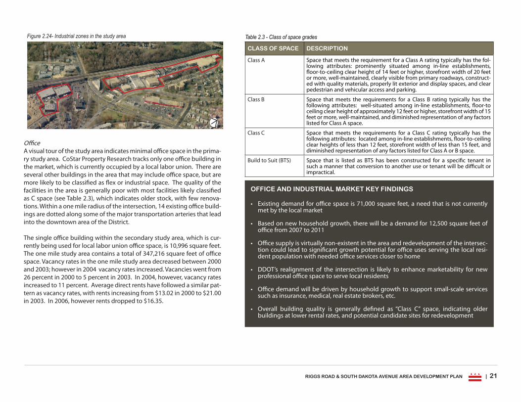
COMMERCIAL OFFICEThere is minimal office space in the primary study area with only one office building cur-rently occupied by a local labor union. There are several other buildings in the area that may include some office space but are more likely to be classified as flex or industrial space.
Figure 2.11- Commercial Office and Flex space buildings
Local Union 657 at 1st Place and Riggs Road Flex building on Riggs Road
INDUSTRIALThere are two industrial zones in the study area that run parallel to the CSX/Metro tracks located to the north and south of Riggs Road.
Figure 2.13- Industrial zones in the study area
NORTH
Fort Totten Overlay District

16
Complementary land uses - apartment dwellings adjacent to local serving retail
Complementary land uses - Tiger Mart retail adjacent to a residential neighborhood with an appropriate buffer
Complementary land uses - Exxon gas station located adjacent to a single family home at Kennedy Street NE.
Conflicting land uses - residential across the alley from industrial land uses at 2nd Street
Conflicting land uses - Apartments next to an auto body shop at Nicholson Street and 2nd Street NE
Conflicting land uses -residential abutted to industrial land uses at 3rd Street
Figure 2.14 - Complementary and Conflicting Land Uses Complementary and Conflicting Land Uses The most successful instances of abutting land uses occur when there is a reciprocal benefit between users. Residential and small scale commercial/retail land uses often harmoniously coexist, providing convenient access to everyday resources within local neighborhoods. These establishments are most successful when they are located within walking distance of patrons and thus do not create excess traf-fic, congestion, or noise associated with their use.
Through good land use planning, an appropriate balance of mixed-uses locates activities in such a way to foster constructive interac-tion. For example, residential areas should not have heavy industrial uses immediately adjacent because the noise and fumes associated with production or distribution could be disruptive. Conversely, resi-dential areas within walkable communities should incorporate local serving commercial retail establish-ments that provide basic goods and services and options for dining out. A proper balance of land uses re-duces the need to drive outside the community to obtain basic necessi-ties. Figure 2.14 shows examples of some disjointed land uses that oc-cur around the intersection.
Leftover and Underutilized SpacesLike many neighborhoods with Metro access, rail tracks, and a ma-jor intersection, the study area has many leftover spaces beneath or around the infrastructure that are not well utilized. These sites in-clude residual spaces too narrow for development, vacant parcels, and abandoned commercial establishments (see Figure 2.15). These areas are often immediately adjacent to stable neighborhoods. These empty spaces provide the opportunity to infill with parks or new de-velopment.
Figure 2.15- Leftover and Underutilized spaces
Towing lot between at Riggs overpass Abandoned gas station at 1st Place Empty lot at the South Dakota rampOpen space at the South Dakota ramp
It is important to have an ap-propriate or suitable buffer between these land uses such as landscaping or an envi-ronmental feature that visu-ally separates the public and private land uses.
KEY FINDINGS
The majority of real estate in the •study area is residential. Converse-ly, there is a lack of commercial of-fice land use.The existing height and scale of •buildings around the intersection is lower than the zoning allowance. Vacant and underutilized parcels •provide the opportunity to infill with redevelopment.

RIGGS ROAD & SOUTH DAKOTA AVENUE AREA DEVELOPMENT PLAN | 17
Pedestrian SafetyDespite an incomplete and occasional-ly non-accessible network of sidewalks (see Figure 2.18), the project area does have well defined crosswalks, particu-larly immediately around the neighbor-hood’s schools and community facili-ties. While streetscape improvements are necessary to improve the character of the area, the key factor in improving pedestrian safety is reducing the speed of vehicles.
The intersection realignment will alleviate congestion and heavy traffic volumes during peak hours in the morning and evening rush hour, and it will reduce the speed of vehicles coming northbound and southbound from Riggs Road, thereby improving the accident rates and overall safety of the area round the intersection. DDOT cites safety as the main catalyst for the planning and implementation of the intersection redesign.
Community IdentityNeighborhoods that lack strong community identity do not encourage civic own-ership or pride. Generally, neighborhoods in the study area have a strong and positive community identity. The volume of long time residents and high rate of owner occupied housing contributes to its family-centric character.
Maintenance In certain neighborhoods, an overall image of vacant and abandoned properties, dilapi-dated storefronts, and unkempt public assets contributes to a general feeling of neglect. The more well-maintained an area is, the less tolerance for disorder exists. Despite several vacant properties and numerous industrial ar-eas, the study area is exceptionally well main-tained. It is populated with a high number of owner occupied single family homes. The quality of the housing stock is good and the exterior structures and landscaping are well maintained.
Figure 2.17- Low visibility areas
COMMUNITY SAFETYCommunity safety involves addressing causes of crime and reducing opportunities for it to occur. It relies on a successful partnership between residents, business own-ers, local law enforcement, schools, and local government to develop strategies that promote and enhance community policing, pedestrian safety, community identity, and maintenance of property.
Community Policing The term community policing refers to local law enforcement working in partnership with the community to reduce and deter crime problems. Police presence is a key factor to crime reduction. In the same way that police radar surveillance reduces ve-hicular speeding, passive (stationary surveillance) and active (patrol) presence in both public and private areas have a statistically proven effect on crime reduction.
In Fall 2006, the District installed closed circuit tv cameras (CCTV) in areas of the city to monitor crime. There is currently one camera in the study area at 6th Street and Riggs Road NE.
In recent years, increased police presence at several places in the project area, such as the Metro, footpaths behind the Mamie Lee school and west Metro parking lots, Tiger Mart, and liquor stores has increased the per-ception of safety in the project area. Police surveillance and patrol of several vacant or isolated places has also reduced the volume of loitering and crime. Figure 2.17 show two examples of these isolated areas with limited visibility from the street. In addition, the Fort Totten Metro and surrounding footpaths, due to their relative seclusion and transient use, are vulnerable to crimes such as assaults and illegal dumping. In recent years, due to an increased DC and Park police presence and the clearing of some pockets of heavy tree cover, there has been a significant decline in crime.
Figure 2.16 - A sign marking illegal dumping
Figure 2.18 - Non accessible sidewalk on Riggs Rd
Behind the Tiger Mart Behind the Lamond Riggs library North side of 1st Place NE
KEY FINDINGS
Generally the properties •in the study area are well maintained and convey a high degree of community identity and civic owner-ship.
There is an opportunity to •improve the walkability of the study area by enhanc-ing the network of pedes-trian footpaths.

18
FOOD and FRIENDS TRIANGLE
FORT TOTTENPARK
FORT SLOCUM
PARK
NORTH
PARKS AND OPEN SPACE
Parks and open spaces are invaluable assets for communities. In addition to making the neighborhoods desirable and aesthetically attrac-tive, parks contribute to community health by encouraging recreation and exercise. Parks also provide places for social interaction. Safe parks are a much better alternative to playing in the streets or gathering in parking lots. Parks also contribute to the environmental health of a community by reducing stormwater runoff and providing a habitat for biodiversity.
While the study area has an ample amount of open space (figure 2.19 shows the parks in the study area), the access and maintenance of these resources needs improvement. An inventory of parks and open spaces in the project area shows that there are currently two large formal parks, Fort Totten and Fort Slocum, owed by National Park Service (NPS), one small community garden park on the Food and Friends property (see Figure 2.20), and two underutilized parcels of open space at the intersection between the South Dakota Avenue ramps, front-ing Food and Friends and the site of the former Dakotas Apartments. The neighborhood’s existing parks and open space areas provide a visually pleasing refuge in which community residents have grown to like. Although many of these de facto pocket parks, such as the Triangle parks properties, are poorly lit, inaccessible to pedestrians, and underutilized, community residents lament the idea of replacing these areas with new development. In Section 3.0, this Plan provides a framework in which new green and open space areas can be tar-geted to enhance proposed development parcels and assist in creating safe, accessible and aesthetically improved destinations for all.
The Metropolitan Branch Trail (MBT) is proposed within the study area, across from the Fort Totten west opportunity site. The proposed eight mile multi-use trail runs from Silver Spring in Maryland to Union Station in the District and includes a segment that will connect the MBT at Fort Totten to the Anacostia Tributaries Trail System in West Hyattsville, Maryland (See Figure 2.19), and a connection to the National Mall. At the Fort Totten Metro Station, the trail would follow contours above Metro’s green line tunnel, to meet the Ameri-
cans with Disabilities Act, (ADA) standards. This alternative provides the most direct and ADA accessible route between John McCormack Road and Riggs Road. The addition of the MBT will enhance safe and acces-sible pedestrian and bicycle connections in the study area. In addition to the MBT, a major city-wide parks and recreational plan-ning effort currently underway is the Capital Space Initiative. DC Parks and Recreation, along with the National Capital Planning Commission and the National Park Service (NPS) are collaborating to promote, protect, enhance, and grow the District’s current parks and open space system.
A special focus of the initiative is the Fort Circle Parks System, which in-cludes Fort Slocum and Fort Totten, in addition to other federally owned open spaces around Civil War-era forts. The results of Capital Space will provide recommendations for park improvements and opportunities for partnerships between the District and NPS to ensure successful implemen-tation.
The Fort Circle parks are used by some local residents for passive recre-ational use, but there is little to no parking. The entrances are not clearly marked (see Figure 2.21) and there is inconsistent police patrolling. As a result, the parks are not well utilized.
Figure 2.19 - Parks and open spaces In the project area
Figure 2.20 - Small park at the Food and Friends
Figure 2.21 - Entrance to Fort Totten Park behind residences at Kennedy Street and
1st Place NE
KEY FINDINGS
While the study area has an •ample amount of open space, the access and maintenance of these resources needs im-provement
There is a strong opportunity •to make the network of green space both safe and acces-sible
MBTMBT spur trailto Hyatsville

RIGGS ROAD & SOUTH DAKOTA AVENUE AREA DEVELOPMENT PLAN | 19
Figure 3.7: Median Household Income, 1990-2011
Source: US Census; ESRI Analyst; ERA 20061990 2000 2006 2011Me
dian H
ouse
hold
Incom
e
60k
50k
40k
30k
Primary Secondary District wide
HouseholdsThe changes in the number of households are smaller than the changes in population. In the short term, the number of households is expected to remain constant or slightly grow. The fact that population is decreasing at a fast-er rate than households are decreasing sug-gests that household size is decreasing (See Figure 2.22). In 2006, there were 696 house-holds in the primary study area and 2,342 in the secondary study area. For reference, there were 9,955 in the one mile radius and 248,338 in the entire District. A more detailed analysis of households and income is provided in the Appendix.
IncomeIn 2006, the median household income in the primary study area was $38,536. In the sec-ondary study area, the median income was $42,959. For reference, the number of house-holds within a one mile radius is, 9,955 and in the District, 248,338. The median income in the District is $40,134. Median household in-come is expected to rise for all the geographic areas. Median household income in the study area however is not forecasted to increase as quickly as the median household income in the District, which is expected to increase by $26,851 between 1990 and 2011.
ECONOMIC DEVELOPMENT AND HOUSINGFor this Area Development Plan, Economic Research Associates (ERA) and Re-tail Compass (RC) conducted a market analysis of the study area. The initial analysis, completed in early 2007 and supplemented in early 2008, provides a conservative assessment of the development opportunity in the neighbor-hood over the long-term. Since completing the analysis, the market has sig-nificantly changed in the District, with the pace of residential sales slowing and prices declining slightly. However, these short-term market changes do not significantly alter the long-term projections in the market analysis.
The market analysis is designed to be a long-term plan with “average annual” assessments of supportable residential development. It is impossible to take into account the timing and severity of the real estate cycle but over the long-term the market will continue to average a certain level of sustained develop-ment and growth. The timing and severity of the market declines will only alter the timelines described in the report by delaying some of the short-term projections (1-5 years) while the analysis assumes that medium and long-term projections will continue to be supportable. While the full market analysis can be found in the Appendix, key findings in demographics (population, income, and households), real estate market conditions, retail market conditions, and demand potential are summarized in this section. The primary real estate mar-ket review analysis includes demand potential for residential, office and other uses and uses the same geographical boundaries (primary and secondary study area) as shown in Figure 1.1.
DEMOGRAPHICSDemographics refers to characteristics of a population such as age and income. Agencies like the US Census Bureau and Metropolitan Washington Council of Governments (MWCOG) collect demographic information and provide data to the public to track economic trends. The economic and retail consultants used such data to produce a snapshot of the current conditions in the study area and project future trends.
PopulationThe population decline experienced by the District between 1970 and 2000 is consistent to the decline in the study area. In 2006, the population was 1,332 people in the primary study area, and 5,490 in the secondary study area. For reference, the population within a one mile radius around the intersection is 24,077 and the District’s population was 572,059. In terms of the composition of the population, there has been a large decrease in the percentage of resi-dents between age group 20-34 while there has been a large increase in the percentage of residents between age group 75-84. A more detailed analysis of population is provided in the Appendix.
Figure 2.22: Average household size, 1990-2000.
Source: US Census; ESRI Analyst; ERA 2006
Study Area Primary Secondary District wide
Hous
ehold
Size
3.0
2.0
1.0
0
1990
2000
1990
2000
1990
2000
Figure 2.23: Median Household Income, 1990-2011
DEMOGRAPHICS KEY FINDINGS
In 2006, the population was 1,332 people in the primary study area, and 5,490 •in the secondary study area.
In 2006, there were 696 households in the primary study area with a median in-•come of $38,359 and 2,342 households in the secondary study area with a median income of $42,959.
While population has steadily declined in the • entire study area and throughout the District in the past 30 years, recent upward trends in population suggest op-portunities for development and growth in the study area.
Resident population could increase by over 3,000 during the next 15 years.•
The • entire study area experienced an increase in the number of households in larger income brackets between 2000 and 2006.
20
IndustrialTwo industrial clusters, one on South Dakota Avenue just north of Riggs Road and one at Kennedy Street, NE and 3rd Street, NE (see Figure 2.24) are also located in the primary study area. The industrial uses are closely aligned with the train tracks to the north of Riggs Road and contain a mix of indus-trial uses. In addition, a cluster of industrial/flex facilities off 3rd Street to the west of the Metro train tracks includes several older buildings that are currently occu-pied by local union offices. An ad-ditional industrial cluster exists on the fringe of the study area to the south of the Metro station and in-cludes a concrete/stone plant and other business.
REAL ESTATE MARKET CONDITIONSReal Estate refers to land and anything attached to it, such as buildings or structures. It is affected primarily by local factors such as the condition of the immediate area where the property is located. Real estate market conditions encompass residential and commercial property including industrial and office land uses.
ResidentialThe majority of the real estate in the study area is existing residential structures. The residential inventory consists of a mix of single-family and multi-family structures with large sections of the study area containing a mix of semi-detached and de-tached single-family residences of varying qualities.
Though multi-family units outnumber single-family units in the District, this is not the case in the study area (See Table 2.1). The number of single-family units greatly exceeds the number of multi-family units. This is consistent with the character of the housing stock and the tradition of the neighborhood as a family-centric, single-family home neighborhood.
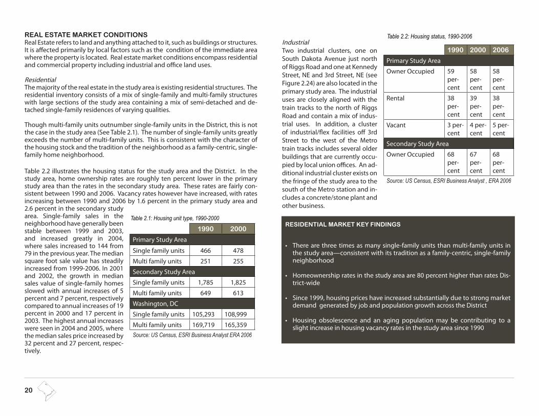
Table 2.2 illustrates the housing status for the study area and the District. In the study area, home ownership rates are roughly ten percent lower in the primary study area than the rates in the secondary study area. These rates are fairly con-sistent between 1990 and 2006. Vacancy rates however have increased, with rates increasing between 1990 and 2006 by 1.6 percent in the primary study area and 2.6 percent in the secondary study area. Single-family sales in the neighborhood have generally been stable between 1999 and 2003, and increased greatly in 2004, where sales increased to 144 from 79 in the previous year. The median square foot sale value has steadily increased from 1999-2006. In 2001 and 2002, the growth in median sales value of single-family homes slowed with annual increases of 5 percent and 7 percent, respectively compared to annual increases of 19 percent in 2000 and 17 percent in 2003. The highest annual increases were seen in 2004 and 2005, where the median sales price increased by 32 percent and 27 percent, respec-tively.
Table 2.1: Housing unit type, 1990-2000
1990 2000
Primary Study Area
Single family units 466 478
Multi family units 251 255
Secondary Study Area
Single family units 1,785 1,825
Multi family units 649 613
Washington, DC
Single family units 105,293 108,999
Multi family units 169,719 165,359Source: US Census, ESRI Business Analyst ERA 2006
Table 2.2: Housing status, 1990-2006
1990 2000 2006
Primary Study Area
Owner Occupied 59 per-cent
58 per-cent
58 per-cent
Rental 38 per-cent
39 per-cent
38 per-cent
Vacant 3 per-cent
4 per-cent
5 per-cent
Secondary Study Area
Owner Occupied 68 per-cent
67 per-cent
68 per-cent
Source: US Census, ESRI Business Analyst , ERA 2006
RESIDENTIAL MARKET KEY FINDINGS
There are three times as many single-family units than multi-family units in •the study area—consistent with its tradition as a family-centric, single-family neighborhood
Homeownership rates in the study area are 80 percent higher than rates Dis-•trict-wide
Since 1999, housing prices have increased substantially due to strong market •demand generated by job and population growth across the District
Housing obsolescence and an aging population may be contributing to a •slight increase in housing vacancy rates in the study area since 1990
RIGGS ROAD & SOUTH DAKOTA AVENUE AREA DEVELOPMENT PLAN | 21
CLASS OF SPACE DESCRIPTION
Class A Space that meets the requirement for a Class A rating typically has the fol-lowing attributes: prominently situated among in-line establishments, floor-to-ceiling clear height of 14 feet or higher, storefront width of 20 feet or more, well-maintained, clearly visible from primary roadways, construct-ed with quality materials, properly lit exterior and display spaces, and clear pedestrian and vehicular access and parking.
Class B Space that meets the requirements for a Class B rating typically has the following attributes: well-situated among in-line establishments, floor-to ceiling clear height of approximately 12 feet or higher, storefront width of 15 feet or more, well-maintained, and diminished representation of any factors listed for Class A space.
Class C Space that meets the requirements for a Class C rating typically has the following attributes: located among in-line establishments, floor-to-ceiling clear heights of less than 12 feet, storefront width of less than 15 feet, and diminished representation of any factors listed for Class A or B space.
Build to Suit (BTS) Space that is listed as BTS has been constructed for a specific tenant in such a manner that conversion to another use or tenant will be difficult or impractical.
Table 2.3 - Class of space grades
OFFICE AND INDUSTRIAL MARKET KEY FINDINGS
Existing demand for office space is 71,000 square feet, a need that is not currently •met by the local market
Based on new household growth, there will be a demand for 12,500 square feet of •office from 2007 to 2011
Office supply is virtually non-existent in the area and redevelopment of the intersec-•tion could lead to significant growth potential for office uses serving the local resi-dent population with needed office services closer to home
DDOT’s realignment of the intersection is likely to enhance marketability for new •professional office space to serve local residents
Office demand will be driven by household growth to support small-scale services •such as insurance, medical, real estate brokers, etc.
Overall building quality is generally defined as “Class C” space, indicating older •buildings at lower rental rates, and potential candidate sites for redevelopment
OfficeA visual tour of the study area indicates minimal office space in the prima-ry study area. CoStar Property Research tracks only one office building in the market, which is currently occupied by a local labor union. There are several other buildings in the area that may include office space, but are more likely to be classified as flex or industrial space. The quality of the facilities in the area is generally poor with most facilities likely classified as C space (see Table 2.3), which indicates older stock, with few renova-tions. Within a one mile radius of the intersection, 14 existing office build-ings are dotted along some of the major transportation arteries that lead into the downtown area of the District.
The single office building within the secondary study area, which is cur-rently being used for local labor union office space, is 10,996 square feet. The one mile study area contains a total of 347,216 square feet of office space. Vacancy rates in the one mile study area decreased between 2000 and 2003; however in 2004 vacancy rates increased. Vacancies went from 26 percent in 2000 to 5 percent in 2003. In 2004, however, vacancy rates increased to 11 percent. Average direct rents have followed a similar pat-tern as vacancy rates, with rents increasing from $13.02 in 2000 to $21.00 in 2003. In 2006, however rents dropped to $16.35.
Figure 2.24- Industrial zones in the study area

22
RetailExisting retail space in the study area is largely confined to parcels immediately adjacent to the Intersection. Dominated by Tiger Mart-anchored Riggs Road Center, additional retail offerings include three pad sites, several isolated es-tablishments, and a collection of storefronts north of the Dakota Apartments. A large percentage of retail spaces appear to be vacant pending redevelopment.
Retail potential for the study area is impacted by nearby, existing retail centers. •These destinations currently draw expenditures from households within the study area. Riggs Road and South Dakota Avenue’s ability to support new retail development is contingent upon redirecting spending to new establish-ments and centers.
Less than half a mile from the study area, Riggs Plaza is a 120,000 square •foot, grocery-anchored neighborhood center. In addition to the goods and services offerings at this location, a bowling alley provides evening and week-end activity for the eastern end of the center.
Impact on the study area’s retail potential: Significant. Riggs Plaza’s »Giant Food store satisfies a considerable amount of local demand for gro-cery needs. Additionally, as an established shopping center, Riggs Plaza is a central part of existing shopping patterns in the community.
Approximately 750,000 square feet in area, Prince George’s Plaza is a su-•per-regional shopping center anchored by Macy’s and JCPenney. With over 100 stores, this large collection of retailers is less than three miles from the project area.
Impact on the study area’s retail potential: Significant. Super-regional »retail centers draw customers from long distances. The ability to capture expenditures from a large trade area is critical to establish and maintain their viability. The neighborhood surrounding the study area is located within Prince George’s Plaza’s primary trade area. For this reason, retail-ers currently located at the super-regional center will hesitate to open a second store so near. Additionally, retailers seeking new locations will first opt for sites at the established Prince George’s Plaza. These market conditions will have the greatest impact on the General Merchandise, Apparel, Furnishings and Other (GAFO) retail categories (see Retail Cat-egories in Figure 2.25).
Located to the north of the study area, Takoma Center and Takoma Park •Shopping Center are grocery-anchored shopping centers.
Impact on the study area’s retail potential: Moderate. These neighbor- »hood centers impact the northern boundary of the study area’s primary trade area, further limiting Riggs Road and South Dakota Avenue’s poten-tial to attract Neighborhood Goods and Services (NGS) spending.
NEIGHBORHOOD GOODS and SERVICES
This category includes basic goods and services establishments that depend upon the patron-age of local residents and workers. Examples of these types of tenants include grocery stores, drugstores, florists, bakeries, specialty food stores, delicatessens, butchers, dry cleaners, tailors, Laundromats, hair salons, nail salons, day spas, printers, pet salons, machine repair shops, shoe repair and shine shops, hardware stores, gyms, and similar.
FOOD and BEVERAGEThis category includes establishments that serve food and/or alcohol consumed outside the home. This category is otherwise known as “Dining Out”. Tenant types in this category include sit-down restaurants, cafes, bars, coffee shops, sandwich shops, ice cream shops, “quick-bite” establishments, fast-food restaurants, and similar.
GENERAL MERCHANDISE, APPAREL, FURNISHING, and OTHER (GAFO)This category includes establishments such as clothing stores, furniture stores, bookstores, jewelry stores, stationery stores, gift boutiques, pet stores, sporting goods stores, home goods stores, craft stores, music stores, antique shops, camera stores, electronics stores, auto parts stores, and similar.
Figure 2.25 - Retail Categories
RETAIL MARKET KEY FINDINGS
Existing retail space in the study area is largely confined to parcels immediately •adjacent to the Intersection. Retail potential for the study area is impacted by nearby, existing retail cen-•ters; the ability to support new retail development is contingent upon redirecting spending to new establishments and centers.Planned, proposed and future development will absorb portions of the retail •demand

RIGGS ROAD & SOUTH DAKOTA AVENUE AREA DEVELOPMENT PLAN | 23
Due to a combination of positive community assets, a strong residential character, proximity to Metro, and increasing housing prices elsewhere in the District, the sur-rounding neighborhoods have immense desirability, and many developers have plans to construct mixed-use projects in the study area. These development proj-ects support the recommended land use changes in the 2006 Comprehensive Plan. The policies in the Comprehensive Plan encourage new development in many areas around the intersection and encourage mixed-use opportunities centered around a new Neighborhood Commercial Center. The anchor for the new develop-ment is the DDOT realignment of the intersection at Riggs Road and South Dakota Avenue, which is likely to enhance marketability for new professional office space to serve local residents.
D C
BE
5TH STREET NE
A
Figure 2.26 - Planned and ongoing development projects in the study area
PLANNED AND ONGOING DEVELOPMENT
Aerial photo from Microsoft Virtual Earth, Pictom-etry International Corp. information © 2007. This photo does not represent current conditions
Riggs Road and South Dakota intersec-A. tion realignmentDakota Apartments/ Lowe Enterprises B. Tiger Mart Site/ Lowe EnterprisesC. Fort Totten Apartments/ Clark RealtyD. Riggs Plaza Apartments/ CafritzE.
4TH STREET
RIGGS ROAD
SOUTH DAKOTA AVENUE
KENNEDY STREETCHILLUM PLACE
5TH STREET NE4TH STREET NE
3RD STREET
2ND STREET
CHILLU M PL
HAM
ILTON
STREET
GALLO
WAY STR
EET
1ST PLACE
KE
NN
ED
Y STR
EE
T
LON
GFE
LLOW
STR
EE
T
MA
DIS
ON
STR
EE
T NEW HAMPSHIRE AVE
JEFFERSON STREET
INGRAHAM STREET
A. INTERSECTION REALIGNMENTDDOT is implementing a full redesign of the Riggs Road and South Dakota Avenue intersection to improve the overall safety of the area and transform the existing scale of the area into an urban commercial corridor. The plan for the intersection redesign is shown in Figure 2.26.
SafetyDDOT cites safety as the primary reason for the realignment. The new configura-tion will reduce the speed of vehicles coming northbound and southbound onto South Dakota Avenue, which will consequently reduce the accident rates and alle-viate congestion and heavy traffic volumes during peak hours in the morning and evening rush hour.
Note 4 (See Appendix)*

24
of the intersection, fronting the Dakotas Apartments and the crescent site retail. When it is transferred to Lowe Enterprises for development, approximately 25 per-cent of the bulk of the Dakotas development will be built on this parcel.
CLARK REALTY CAPITALClark Realty broke ground in March 2007 for the development of Fort Totten Station, a 308-unit luxury apartment community adjacent to the Metro station. Construc-tion will be phased. Phase 1 construction includes 128 apartment rental units and 153 associated parking spaces. Phase 2 includes 135 additional apartment rental units and 162 associated parking spaces. There is approximately 8,000 square feet of retail proposed with this development.
RIGGS PLAZA APARTMENTSThe Cafritz Company currently owns the property and plans to demolish the exist-ing units and construct additional resi-dential units. The total proposed planned unit development includes 826 multi-family units, over 280,000 square feet of retail development, 215,000 square feet of arts and cultural uses and approximate-ly 2,282 parking spaces.
Figure 2.28 - Riggs Plaza Apartments
INTERSECTION REALIGNMENT (continued)In addition, the new plans will include improvements for pedestrian safety, such as an accessible network of sidewalks and new landscaping, street furniture, and signage.
Scale and Character The realignment also provides an opportunity to create an urban corridor with street facing mixed-use opportunities. As described in the Urban Design existing conditions analysis, the current scale at the intersection makes the street seems excessively wide is caters more to vehicles than pedestrians. In addition to pedes-trian enhancements, the new development building heights and setbacks will pro-vide natural traffic calming measures for the study area around the intersection. To support this new mixed-use development, the plans provide for metered street parking along Riggs Road, north of South Dakota Av-enue, next to the new retail development.
LOWE ENTERPRISESThe Tiger Mart site was acquired by the developer Lowe Enterprises in 2006. The existing Tiger Mart and Dakotas Apartments will be demolished and a new mixed-use development known as ‘The Dakotas’, will replace it. Current de-velopment plans call for multiple structures across Riggs Road and will result in 835 new mixed-income condo units and apart-ments and 105,000 square feet of retail including a grocery store and restaurant. A certain percentage will be re-served for affordable housing. The new development will provide parking for approximately 640 cars. A structured facil-ity is proposed as part of the development on the former Tiger Mart site, which will accommodate 550 of the spaces. Lowe Enterprises has negotiated the purchase of the triangle parcel to the east
Figure 2.27 - DDOT realignment for the Riggs Road and South
Dakota Avenue intersection
Table 2.4 - Summary of proposed build out in the study area
INFORMATION OBTAINED BY OP IS SUBJECT TO CHANGE
DEVELOPER RESIDENTIAL RETAIL PARKING
Lowe EnterprisesDakotas - 171 multi family N/A 90 spaces
Tiger Mart- 420 multi family 85,000 sf 550 spaces
Triangle - 235 multi family 20,000 sf N/A
TOTAL 826 units 105,000 sf 640 spaces
Clark Realty Capital “Fort Totten Station Apartments”
Phase 1 - 128 condo units 153 spaces
Phase 2 - 135 condo units 162 spaces
TOTAL 263 condo units 8,000 sf 315 space
Riggs Plaza AptsCafritz Foundation
Phase 1 - 426 apt units 87,000 sf 602 spaces
Phase 2 - 400 apt units 203,000 sf 1,680 spaces
TOTAL 826 apt units 287,000 sf 2,282 spaces
TOTAL 1,915 new units 400,000 sf 3,237 spaces

RIGGS ROAD & SOUTH DAKOTA AVENUE AREA DEVELOPMENT PLAN | 25
3.0 REDEVELOPMENT FRAMEWORK PLAN

26
REDEVELOPMENT FRAMEWORK PLAN
This section provides a framework for redevelopment focused on several parcels around the intersection that are currently underutilized or have the potential to catalyze revitalization in the entire study area. Targeted redevelopment of these sites will enhance the housing and commercial (office and retail) opportunities and improve the scale, character, and walkability of the study area. The redevelopment framework is guided by several overarching principles and identifies proposed ac-tions for achieving the overall vision for both short-term and long-term growth in the study area.
OPPORTUNITY SITE SELECTION METHODOLOGY
Each opportunity site was evalu-ated independently and in concur-rence with the remainder of the study area to identify appropriate potential uses for redevelopment. Currently, the area is largely un-derdeveloped with scattered open spaces, older structures, and busi-nesses. As a result, there are nu-merous sites for potential redevelopment based on two basic criteria: the condition of the facilities and its land value.
Tables 3.1- 3.6 summarizes the development opportunities in the study area. Exist-ing onsite and surrounding land uses were analyzed along with existing and pro-jected trends for population, housing, offices, and retail, and a proposed land use for each of the opportunity sites was developed. Each opportunity site combines numerous parcels to form a larger lot for redevelopment purposes. Detailed infor-mation in terms of ownership, zoning, size, and address is available upon request for each of the parcels; however, for ease of discussion, the information has been
combined in the table according to individual opportunity site boundaries. There are challenges to selecting redevelopment opportunity sites and to identifying their consequent potential uses. Selecting specific uses and determining expected development on particular sites at present is premature and would consist mainly of uneducated guesses without providing any valuable metric to guide develop-ment. Instead, this framework provides general guidelines that include a timeline for redevelopment, priority/opportunity sites for redevelopment, and proposed broad redevelopment uses for the opportunity sites.
The Plan also provides guidance on how each opportunity site relates to the Com-prehensive Plan’s Land Use designation categories. Land Use designations illustrat-ed in the Comprehensive Plan’s Future Land Use Map provide guidance on how the District is expected to change during the next two decades. It highlights the places where much of the city’s future growth and change is expected to occur and sets the stage for how development anticipated in this planning process should either remain the same or change, based on the Plan’s guiding principles and develop-ment goals. Although this plan does not recommend any zoning changes, it does either support the current land use designation per the Comprehensive Plan or rec-ommends a change to a more appropriate designation. The following are land use designation definitions that pertain to the study area:
Moderate Density Commercial and Residential uses: Typically defines commer-cial uses that provide a broad range of goods and services that are predominatly uses such as drug and grocery stores, as well as branches of department stores. Residential moderate uses are generally low to moderate density uses, such as row houses or garden apartments. The Zones that are consistent with this desig-nation includes (R-3, R-4, R-5-A, and R-5-B, and C-2-A, C-2-B and C-3-A)
Medium Density Commercial and Residential uses: This mix of uses defines resi-dential development as medium density housing. This housing type generally includes multiple unit housing and mid-rise apartment buildings. Commercial uses in this category generally offer a large concentration and variety of goods and services. Zoning categories range from R-5-B, R-5-C, C-2-B, C-3-C, C-3-A, and C-3-B.
Production, Distribution and Repair: This land use category is used to define ar-eas characterized by manufacturing, warehousing, wholesale and distribution centers, and other similar types of uses that require substantial buffering. The corresponding Zone districts are generally CM-1, CM-2, CM-3 and M, although other districts may apply.
This small area plan recommends land use designation changes for three oppor-tunity sites. For these opportunity sites, changes to the underlying zoning will oc-cur through the Zoning Map amendment process. A property owner or developer may propose a Zoning Map amendment, which is reviewed and approved by the District’s Zoning Commission. Public review and comment are essential to this dis-
What Is An Opportunity Site?An opportunity site is a site identified by the project team as suitable for redevelopment. Many factors determine the selection including proximity to intersections or other developed parcels, other commercial activity, public trans-portation, undeveloped or underutilized parcels allowing consolidation for larger developments, major thoroughfare routes, parking, and current neighborhood conditions and demand.
GUIDING PRINCIPLES These principles are based on the outcomes of the public involvement process, existing conditions analysis, market analysis (which informs the type, density, and scale of development) and District priorities:
Establish a dynamic neighborhood center at Riggs Road and South Dakota •Avenue that enhances community character and reactivates the street Attract development that serves all generations•Connect, activate, and create new open spaces•Promote safe access and circulation throughout the neighborhood•

RIGGS ROAD & SOUTH DAKOTA AVENUE AREA DEVELOPMENT PLAN | 27
RIGGS ROAD and SOUTH DAKOTA AVE AREA DEVELOPMENT PLAN OPPORTUNITY SITES1. KFC/Taco Bell 2. Riggs Road North Industrial Site3. Riggs Plaza Apartments/ Cafritz and Food and Friends/ DC Gov-ernment Triangle4. Riggs Road South Industrial Park5. Fort Totten East Industrial Site 6. Fort Totten West
4
2
1
3
5
Figure 3.1 - Opportunity sites in the study area
6
4TH STREET
RIGGS ROAD
SOUTH DAKOTA AVENUE
KENNEDY STREETCHILLUM PLACE
5TH STREET NE4TH STREET NE
3RD STREET
2ND STREET
MADISON S
TREET
CHILLU M PL
HAM
ILTON
STREET
GALLO
WAY STR
EET
1ST PLACE
1ST STREET
KE
NN
ED
Y STR
EE
T
LON
GFE
LLOW
STR
EE
T
MA
DIS
ON
STR
EE
T
NEW HAMPSHIRE AVENUE
JEFFERSON STREET
INGRAHAM STREETNorth
Opportunity Sites
Planned or Ongoing Development
cretionary approval process. For all other opportunity sites where no land use designation is proposed, the existing zoning still applies.
If additional flexibility within a zoning category is needed for large sites, a developer may also apply for a Planned Unit Development (PUD). PUDs are also reviewed and approved by the Zoning Commission. PUDs may include requests to increased building heights and/or density provided that the project of-fers commendable public benefits (i.e. public space improvements and/or affordable housing). A PUD may be coupled with a Zoning Map amendment application. In both cases, the recommendations of this small area plan are critical to the Zoning Commission and public review process.
WHAT IS A PUD?A Planned Unit Development (PUD) is a proj-ect-specific zoning case, heard and decided by the Zoning Commission. The PUD process is designed to encourage high quality devel-opments that provide public benefits.
Note 1, 2, 3 (See Appendix)*

28
Figure 3.2 - Location Map of the KFC/ Taco Bell Opportunity Site
SOUTH DAKOTA AVE
KFC/TACO BELL
The KFC/Taco Bell is located at the northwest corner of the intersec-tion. As a reference, Figure 3.3 shows the site as it was in 1952.
The opportunity site includes one large two-story building that con-tains several individual businesses including a child care center, beau-ty shop, liquor store, and a sandwich shop. In addition, the site includes a small vacant lot on the west used for towed cars and a combined KFC/Taco Bell establishment on the east with an associated parking lot at the back. There is vacant com-mercial space on the second floor of the existing large commercial building and vacant undeveloped land behind. While the commercial building is slightly dilapidated and in fair condition the KFC/Taco Bell is in good condition.
RECOMMENDATIONS Development MixThis opportunity site presents a longer-term redevelopment op-portunity because of the existing businesses on the site. Addition-ally, the site is small and fairly seg-regated with the Metrorail line re-stricting development to the west and is significantly different from existing industrial parcels to the north. While frontage to Riggs Road is an advan-tage, the site will only see long-term spill over retail development from the Tiger Mart site. Over the long-term, with a reconfigured intersection, this site may provide an opportunity for pedestrian-scale, street-facing retail uses.Lack of large empty parcels to the north of the opportunity site limit the possibility of planning for transitional land uses.
Urban DesignCurrently, there are incongruous land uses on the site, scattered buildings, and overgrown undeveloped vacant patches of land. To the north the site abuts the industrial parcels with no formal transition space or buffer between the sites. While there are existing sidewalks along the southern and eastern edge of the site, they are punctured at numerous places to allow for vehicle entry/exit points.
Development Scale•The existing KFC/Taco Bell retail establishment is the only building that fronts the intersection. While future development should follow a similar setback, the relationship to the adjacent parcel should be strengthened. Currently, the KFC/Taco Bell and C.H.I.L.D. facility to the north are distinct and separate entities; their scale, massing, and articulation are completely dissimilar. The goal for future de-velopment is to create a visually strong corner with an aesthetically unified mass-ing and street facing retail around the intersection. The height of development at the intersection should not exceed 65 feet by right or maximum 90 feet through a Planned Unit Development, a discretionary approval by the District’s Zoning Commission.
Pedestrian Friendly Scale/ Connectivity to Metro •The proposed development of a commercial corridor marked with four strong corners of mixed-uses will provide community amenities that are transit acces-sible, furthering the goal of creating a transit-oriented development (TOD) des-tination. In order to ensure the success of this TOD, sidewalks around the op-portunity site will need to tie into the pedestrian circulation of the future Lowe Enterprises development (on the former Tiger Mart site) and go on further to connect to the Metro. Adequate signage and lighting will be essential to improve the existing pedestrian experience. There will be short-term challenges with con-nectivity because the western crosswalk (connecting Food and Friends to KFC) will not be available to pedestrian traffic. However, additional measures to miti-gate this inconvenience will be addressed by DDOT and OP in future implemen-tation activities subsequent to this planning process.
Access Management•It is likely that new development will have to accommodate ingress and egress off of 3rd Street NE, rather than the current point of access of Riggs Road. To en-hance desirability of development, a rear alley may also have to be designed to accommodate service access and loading.
Community Identity•Being a corner site at the intersection, the site has the potential to accommodate landmark elements, such as public art or other aesthetic improvements, to truly create a sense of place and assist with reestablishing the intersection as the heart of the neighborhood. In addition, these physical amenities can provide visual linkages to pedestrians and vehicular traffic approaching the intersection or go-ing towards the Metro station.
Figure 3.3 - Riggs Road and South Dakota Avenue May 14, 1952. Photo courtesy of DDOT
SOUTH DAKOTA
RIG
GS
ROAD
AB
C

RIGGS ROAD & SOUTH DAKOTA AVENUE AREA DEVELOPMENT PLAN | 29
Towing lot at the Metro overpass Disconnect between the KFC/Taco Bell and C.H.I.L.D. parcels
LOCATION OWNER PARCEL SIZECURRENT ZONING
CURRENT LAND USECOMP PLAN FUTURE
LAND USE
A. KFC/TB - 220 Riggs Rd. Riggs Investment Inc. 47,221 sf or 1.08 acres C-M-1 Commercial/Garage or
Unimproved land Production, Distribution, and RepairB. C.H.I.L.D. Facility - 210 Riggs Road NE George Gouzouils
C. Tow Lot -210 Riggs Road NE Parvin Moradi
PROPOSED LAND USE and DEVELOPMENT SCALE
PROPOSED USE URBAN DESIGN GUIDELINES
Change - Plan supports a land use designation change from PDR to a
medium density, mixed-use land use designation and corresponding de-velopment scale. This change would mirror the proposed development
scale and accommodate mixed-uses as consistent with the adjacent
developable parcels.
Mixed-use development with street-oriented retail and housing or
office above
The development around the intersection should reinforce the four corners of street-activated retail uses and be aestheti-•cally consistent in scale and character with the adjacent corners.
The streetscape elements should be appropriate in scale to the adjacent development and reinforce a more pedestrian •friendly environment north toward 1st Place NE, a key path of connectivity to the Metro.
Maintain the continuity of development fronting the intersection and utilize 3rd Street NE as the sole point of ingress/•egress to the parcel.
Create a landmark element at this parcel that can simultaneously orient pedestrians, cyclists and mortorists.•
The height of development at the intersection should not exceed 65 feet by right or maximum 90 feet through a Planned •Unit Development, a discretionary review by the District’s Zoning Commission.
Table 3.1 - KFC/Taco Bell Opportunity Site
Table 3.1 summarizes the development opportunities for this site in the study area within the context of a redevelopment framework timeline. A map with detailed square and lot numbers is located in the Appendix.
Figure 3.4 - Existing Conditions images at the KFC and Taco Bell Opportunity Site

30
RIGGS ROAD NORTH INDUSTRIAL PARK
This industrial opportunity site is bordered by the Met-ro rail tracks on the west and 3rd Street NE on the east. The site contains several large industrial buildings, as well as ample parking and loading space associ-ated with the industrial use. Majority of these buildings are in fair to good condition and many of these buildings have shared car and truck parking spaces. The build-ings back to the train tracks and cover almost the entire site. The site’s proximity to transit provide for attractive opportunities to accomo-date green collar jobs in the future.
RECOMMENDATIONS Development Mix The Riggs Road North opportunity site was further analyzed after the Plan’s public comment period and recommended to support a land use designation change from PDR to Moderate Density mixed-use. This site’s unique location and proximity to future mixed-use development makes it optimal to support the District’s emerging green economy.
A recent demand analysis study conducted by OP and the Washington Eco-nomic Partnership found that the District has significant potential to create and support about 170,000 green collar jobs over the next 10 years. Incubat-ing new companies at this site over the next few years can provide catalytic economic revitalization benefits to this otherwise underutilized site. This Plan supports a mid-term transition to uses supporting the green industry, com-mercial and office.
Urban DesignA poorly maintained industrial area can be an eyesore for the area undergo-ing positive transition. While the industrial uses on the opportunity site are likely to stay in the long term, urban design improvements and landscape ele-ments can be integrated to provide a more suitable buffer to the residential areas to the south and east.
Development Scale•Proposed zoning allows development height of 50 feet, and 65 feet with a
PUD discretionary approval by the District’s Zoning Commission. Development should be consistent with the adjacent KFC/Taco Bell development, despite the higher density allowed by that site. The site could work well as a green collar mixed-use industrial site, similar to the Fort Totten East opportunity site in the near term. Future development should be compatible to adjacent land uses, provide adequate setbacks, and sufficient buffers, including thick vegetation and other amenities capable of absorbing sound from adjacent properties. Future building height should be concentrated towards the Metrorail tracks and step down towards the intersection, enhancing pedestrian activ-ity.
Access Management and Connectivity•Current vehicular circulation patterns within and around the site are haphazard and include a mix of large trucks and smaller cars. Proposed new redevelopment around the site will add vehicular and pedestrian traffic onto the roads surrounding the opportunity site. As a result, clearly defined entry/exit points and well designed vehicular circulation will need to be incorporated on this site.
Pedestrian Safety•Structured pedestrian circulation patterns around the site are virtually non existent. The pedestrian experience around the industrial site is unpleasant due to lack of adequate lighting and street trees and long, horizontal blank facades. Currently there are sidewalks and footpaths along the eastern edge of the site, but they are punctured at numerous places to accommodate entry/exit points to the site. The pedestrian circulation will tie into the neighboring retail center’s circulation pattern. Paving and street furniture can be used to transition the pedestrian experience from retail uses near the intersection to residential uses towards the periphery. In addition, adequate pedestrian crossing points and visual linkages will need to be added to connect the site to areas across Riggs Road NE and the Metro station. Future development should emphasize well defined and well illuminated pedestrian connections to the Metro and the South Dakota/Riggs Road in-tersection.
METRORAIL TRACKS
RIG
GS
RD
2ND ST NE
3RD ST NE
Figure 3.6 - Aerial View of the Riggs Road North Opportunity Site
Figure 3.5 - Location Map of the Riggs Road North Opportunity Site
A
B
C

RIGGS ROAD & SOUTH DAKOTA AVENUE AREA DEVELOPMENT PLAN | 31
LOCATION OWNER PARCEL SIZECURRENT ZONING
CURRENT LAND USECOMP PLAN FUTURE
LAND USE
A. 5648, 5642, 5646 3rd St. NE May Rossett Aaronson Trustee
159,274 sf or 3.65 acres
C-M-1 Low bulk
commerical and light manufacturing
Commercial/Garage or Unimproved land
Production, Distribution, and Repair
B. 5510 3rd St NE BP Dakota LLC
C. 2nd St NE WMATA
PROPOSED LAND USE and DEVELOPMENT SCALE
PROPOSED USE URBAN DESIGN GUIDELINES
Change. Plan supports a change from PDR to Moderate density mixed-use development. This change would be compatible with proposed de-velopment scale on adjacent parcels and accom-modate a mix of uses to include those consistent
with the emerging green collar Jobs Economy.
Residential to mixed-use.
Commercial area with possible long term retail and/or residential
development
Ensure future development scale and character is compatible with the neighborhood. •Provide adequate buffers between the commerical or industrial land uses and the adjacent residen-•tial land uses. Create well defined and well illuminated pedestrian walking paths to connect to the Metro and the •intersection. Ensure that future development provides an appropriate transition in scale from the Metro overpass to the intersection and adjacent areas.The height of development should not exceed 50 feet by right or a maximum of 65 feet through a •PUD, a discretionary review by the District’s zoning commission.
Table 3.2 summarizes the development opportunities for this site within the context of a redevelopment framework timeline. A map with detailed square and lot numbers is located in the Appendix.Table 3.2 - Riggs Road North Industrial Park Opportunity Site
Figure 3.7 - Existing Conditions at the Riggs Road North Opportunity Site from 3rd Street NE and Chillum Place NE
Figure 3.8 - Existing Conditions at the Riggs Road North Opportunity Site from 3rd Street NE and Chillum Place NE

32
RIGGS PLAZA APARTMENTS, FOOD and FRIENDS, and TRIANGLE SITEThis opportunity site is located on the southwest intersection of South Dakota Avenue and Riggs Road. The site follows South Da-kota Avenue to the south and includes fifteen three-story apart-ment buildings owned by South Dakota Trustees and the Cafritz Foundation. Therse parcels signifi-cantly setback the site from South Dakota Avenue NE and Hamilton Street NE.
RECOMMENDATIONSDevelopment MixThe Riggs Plaza Apartments /Ca-fritz Foundation development, while recently scaled back, presents a strong opportunity for the area to add signifi-cant numbers of residents that will bring vibrancy to the neighborhood. Proposed development plans for the site include adding over 800 units of multi-family hous-ing, including senior housing, and over 280,000 square feet of retail uses, including a full-service grocery store. There are significant opportunities for public amenities, including a proposed library. The provision of green and open space opportunities should also be considered within the development framework of any proposal. The development of workforce housing near the Metro location, with a small amount of small-scale retail, will increase activity in the neighborhood and spur development near the Fort Totten Metro. The proposed residential and retail development on the opportunity site is complementary to the residential clusters across South Dakota Avenue NE, but the opportunity site’s proximity to the Fort Totten Metro provides long term opportunities for transit-oriented development for currently vacant par-cels surrounding the site. Development on the opportunity site will benefit from the extension of 3rd Street NE to the south. In the long term, the opportunity site will be predominantly residential surrounded by commercial, small office and retail uses.
The Food and Friends is located north of the site. While it buffers the opportunity site from the busy Riggs Road thoroughfare, it also acts as a transitional site be-tween the retail uses around the intersection and the predominantly residential uses to the south. This site can provide an important anchor for future residential development and a landmark to direct pedestrian and vehicular traffic to the op-portunity site. This site, given the existing supply in residential and retail develop-ment, should be considered a long-term redevelopment opportunity that could potentially serve as an attractive mixed-use location for retail facing Riggs Road and
residential on the site’s south side in connection with other residential development areas. In future development, this site may be assembled with the parcels in the Fort Totten East Industrial Site, to create a larger site for a coordinated, mixed-use devel-opment. Both sites will be long-term development options and would provide good linkages between Riggs Road and other planned and current residential complexes closer to the Metro station.
The triangle parcel at the southwest corner of the intersection at Riggs Road and South Dakota is currently undeveloped. In the short term, this parcel could be trans-ferred and converted into a an active, multi-functional open space. Throughout the public outreach process, numerous residents stated their desire for more open space or parkland in the project area. This centrally located parcel could provide an interme-diate public asset, while the development for the remainder of the parcel is resolved. Landscape elements should mitigate the steep slope by making a plaza or park that is fully accessible. The development in the Riggs Plaza Apartment site can be phased to accommodate street level commercial and retail opportunities at the southwest corner of the intersection. Development of a strong retail corner could dramatically reshape the neighborhood in the short-term
Urban Design Development Scale•Currently, the intersection is defined by low buildings with wide setbacks. By front-ing the street corners with taller buildings, a more appropriate scale could be achieved, similar to other urban retail commercial corridors in the District. The Vi-sioning Section 5.0 of this document presents the proposed scale and character of a strong retail oriented intersection. In the short term, if the triangle parcel is con-verted to a public green space, the landscape design will have to mitigate the steep slope of the parcel (in excess of 25 percent in some places) to make the park acces-sible to residents. The height of development at the intersection should not exceed 65 feet by right or maximum 90 feet through a PUD, a discretionary approval by the District’s Zoning Commission. Development south of the intersection along South Dakota should complement the scale of adjacent residential neighborhoods and step back in height as appropriate per the regulations of the appropriate Zone. See page 14 for additional guidance on the Fort Totten Overlay Zone.
Pedestrian Friendly Scale/ Connectivity to Metro•Presently, both vehicular and pedestrian access to the Metro is poorly defined with abruptly ending roads and informal dirt footpaths cutting through lots. Both the Cafritz Foundation and WMATA have a longer term interest in improving the area and should partner to provide streetscape enhancements. Some space, either on the opportunity site or south of it, can be reserved to continue the abrupt ending of Ingraham and Jefferson Streets up to the Metro. In addition, entrance/exit points to the proposed residential development and the Metro stop should be enhanced through landscaping elements like tree lined streets, signage, and street furniture.
Figure 3.9 - Location Map of the Riggs Plaza Area
A
B
C
DSOUTH DAKOTA
4TH ST.
KENNEDY
Note 6 (See Appendix)*

RIGGS ROAD & SOUTH DAKOTA AVENUE AREA DEVELOPMENT PLAN | 33
LOCATION OWNER PARCEL SIZECURRENT ZONING
CURRENT LAND USE
COMP PLAN-FUTURE
LAND USE
PROPOSED LAND USE and DEVELOPMENT SCALE
PROPOSED USE
A. 5216-5234 4th Street NE
South DakotasTrustee, Inc. 207,152 sf or
4.75 acres
R-5-ALow densityapartments
Residential,Multi-family Medium Den-
sity, Mixed-use
No Change. This Plan supports current land use designation that is consistent with a medium density, mixed-use land use designation and development scale as supported by the Comprehensive Plan
Residential to mixed-useMixed-use/
RetailB. 310 and 320 Kennedy St NE
Cafritz Foundation
C. 219 Riggs Road NE Food and Friends 2.73 acres C3A/Fort Totten
Overlay Light Industrial
D. Triangle parcel 219 Riggs Rd
DC Government .96 acres C3A/Fort Totten
Overlay Open SpaceProduction, Distribution, and Repair
Change. This Plan supports a land use designation change from PDR to a medium density, mixed-use land use designation and corresponding develop-
ment scale. This change would mirror the proposed development scale and accommodate mixed-uses
as consistent with the adjacent developable parcels.
Multi-func-tional open
space
The pedestrian sidewalks along prominent streets can be wider with different paving patterns than other residential sidewalks with clearly defined well lit circulation leading up to the Metro station. Table 3.3 summarizes the development opportunities for this site in the study area within the context of a redevelopment framework timeline. An enlarged map with detailed square and lot numbers can be found in the Appendix.
Table 3.3 - Riggs Plaza Apartments and DC Government Triangle Site
Riggs Plaza Apartments from South Dakota
Food and Friends facility from South Dakota looking west
Figure 3.10 - Existing Conditions at the Riggs Plaza Apartments and DC Government Triangle SiteURBAN DESIGN GUIDELINES
Reinforce the four corners of the intersection with street-activated retail uses.•
Encourage aesthetically consistent development that is in scale and character with •the adjacent corners; storefronts should use compatible fenestration, colors, and signage to create a sense of place.
Promote compatible streetscape elements around the intersection (street lamps, •furniture, sidewalks) that are appropriate in scale to the adjacent development and reinforce a pedestrian-friendly environment from the intersection to the Metro.
Extend the scale of development, articulated building facades, and streetscape ele-•ments at the intersection to the south, along South Dakota Avenue, to encourage walkability to and from the Metro.
Support the creation of walkable blocks along South Dakota Avenue of less than •250 feet. New development should also maintain the existing public street network. In order to achieve walkable blocks and enhance connectivity to the Metro, new de-velopment should pursue opportunities to expand the grid and create new streets.
Capitalize on the close proximity to the Metro by pursuing reduced parking counts, •shared parking opportunities, and participating in a parking district pilot.
The height of development at the intersection should not exceed 65 feet by right or •maximum 90 feet through a PUD. See page 14 for FT Overlay guidance.
Development south of the intersection along South Dakota should complement the •scale of adjacent residential neighborhoods and step back in height as appropriate per the regulations of the appropriate Zone.
South Dakota Avenue looking north
Riggs Plaza Apartments from 4th Street NE
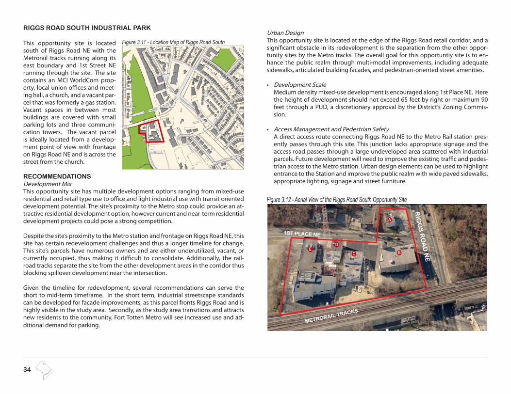
34
RIGGS ROAD SOUTH INDUSTRIAL PARK
This opportunity site is located south of Riggs Road NE with the Metrorail tracks running along its east boundary and 1st Street NE running through the site. The site contains an MCI WorldCom prop-erty, local union offices and meet-ing hall, a church, and a vacant par-cel that was formerly a gas station. Vacant spaces in between most buildings are covered with small parking lots and three communi-cation towers. The vacant parcel is ideally located from a develop-ment point of view with frontage on Riggs Road NE and is across the street from the church.
RECOMMENDATIONS Development MixThis opportunity site has multiple development options ranging from mixed-use residential and retail type use to office and light industrial use with transit oriented development potential. The site’s proximity to the Metro stop could provide an at-tractive residential development option, however current and near-term residential development projects could pose a strong competition.
Despite the site’s proximity to the Metro station and frontage on Riggs Road NE, this site has certain redevelopment challenges and thus a longer timeline for change. This site’s parcels have numerous owners and are either underutilized, vacant, or currently occupied, thus making it difficult to consolidate. Additionally, the rail-road tracks separate the site from the other development areas in the corridor thus blocking spillover development near the intersection.
Given the timeline for redevelopment, several recommendations can serve the short to mid-term timeframe. In the short term, industrial streetscape standards can be developed for facade improvements, as this parcel fronts Riggs Road and is highly visible in the study area. Secondly, as the study area transitions and attracts new residents to the community, Fort Totten Metro will see increased use and ad-ditional demand for parking.
Urban DesignThis opportunity site is located at the edge of the Riggs Road retail corridor, and a significant obstacle in its redevelopment is the separation from the other oppor-tunity sites by the Metro tracks. The overall goal for this opportuntiy site is to en-hance the public realm through multi-modal improvements, including adequate sidewalks, articulated building facades, and pedestrian-oriented street amenities.
Development Scale •Medium density mixed-use development is encouraged along 1st Place NE. Here the height of development should not exceed 65 feet by right or maximum 90 feet through a PUD, a discretionary approval by the District’s Zoning Commis-sion.
Access Management and Pedestrian Safety•A direct access route connecting Riggs Road NE to the Metro Rail station pres-ently passes through this site. This junction lacks appropriate signage and the access road passes through a large undeveloped area scattered with industrial parcels. Future development will need to improve the existing traffic and pedes-trian access to the Metro station. Urban design elements can be used to highlight entrance to the Station and improve the public realm with wide paved sidewalks, appropriate lighting, signage and street furniture.
Figure 3.11 - Location Map of Riggs Road South
1ST PLACE NE
RIG
GS
RO
AD
NE
METRORAIL TRACKS
Figure 3.12 - Aerial View of the Riggs Road South Opportunity Site
A
BC
DE

RIGGS ROAD & SOUTH DAKOTA AVENUE AREA DEVELOPMENT PLAN | 35
LOCATION OWNER PARCEL SIZECURRENT ZONING
CURRENT LAND USECOMP PLAN FUTURE
LAND USE
115 Riggs Rd NE Dominion Church
232,395 sf or 5.33 acres
C3A/Fort Totten Overlay
C-M-1 Low bulk
commerical and light manufacturing
Commercial/Garage or Unimproved land Med Density, Mixed-use
5335 1st Place NE Dominion Church
5321 1st Place NE Communications Workers of America Local 2336
5201 1st Place NE Bricklayer’s Masons Laborer Union 74
120-140 Ingram St NE MCI Telecommunications
Intersection at Riggs Road and 1st Place NE looking north 1st Place NE looking west
Table 3.4 summarizes the development opportunities in the study area within the context of a redevelopment framework timeline. A map with detailed square and lot numbers is located in the Appendix.
Table 3.4 -Riggs Road South Industrial Park Opportunity Site
Figure 3.13 - Existing Conditions at the Riggs Road South Opportunity Site
PROPOSED LAND USE and DEVELOPMENT SCALE
PROPOSED USE URBAN DESIGN GUIDELINES
No Change. The Plan supports the current land use designa-tion that is consistent with a medium density, mixed-use land use designation and development scale as supported by the Comprehensive Plan.
Residential or
Commercial mixed-use
Establish a streetscape concept that integrates multiple modes of transportation into one •node (including bus, pedestrian, bicycles, and vehicles).
Establish visual continuity and create a dynamic sense of place through the development of •active ground floor uses, public art, and public spaces along 1st Place NE.
Make 1st Place NE into a better connection thoroughfare to Metro and encourage and im-•prove pedestrian connectivity.
The height of development should not exceed 65 feet by right or a maximum of 90 feet •through a PUD, a discretionary review by the District’s Zoning Commission. See page 14 for additional regulations per the Fort Totten Overlay Zone.
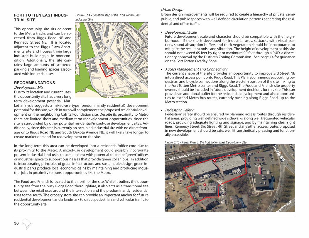
36
FORT TOTTEN EAST INDUS-TRIAL SITE
This opportunity site sits adjacent to the Metro tracks and can be ac-cessed from Riggs Road NE and Kennedy Street NE. It is located adjacent to the Riggs Plaza Apart-ments site and houses three large industrial buildings, all in poor con-dition. Additionally, the site con-tains large amounts of scattered parking and loading spaces associ-ated with industrial uses.
RECOMMENDATIONS Development MixDue to its location and current uses, the opportunity site has a very long term development potential. Mar-ket analysis suggests a mixed-use type (predominantly residential) development potential for this site, which in turn will complement the proposed residential devel-opment on the neighboring Cafritz Foundation site. Despite its proximity to Metro there are limited short and medium term redevelopment opportunities, since the site is surrounded by other potential residential/mixed-use development sites. Ad-ditionally, since this area is currently an occupied industrial site with no direct front-age onto Riggs Road NE and South Dakota Avenue NE, it will likely take longer to create market demand for redevelopment on the site.
In the long-term this area can be developed into a residential/office core due to its proximity to the Metro. A mixed-use development could possibly incorporate present industrial land uses to some extent with potential to create “green” offices or industrial space to support businesses that provide green collar jobs. In addition to incorporating principles of green infrastructure and sustainable design, green in-dustrial parks produce local economic gains by maintaining and producing indus-trial jobs in proximity to transit opportunities like the Metro.
The Food and Friends is located to the north of the site. While it buffers the oppor-tunity site from the busy Riggs Road thoroughfare, it also acts as a transitional site between the retail uses around the intersection and the predominantly residential uses to the south. The grocery store site can provide an important anchor for future residential development and a landmark to direct pedestrian and vehicular traffic to the opportunity site.
Urban DesignUrban design improvements will be required to create a hierarchy of private, semi-public, and public spaces with well defined circulation patterns separating the resi-dential and office traffic.
Development Scale•Future development scale and character should be compatible with the neigh-borhood. If the site is developed for industrial uses, setbacks with visual bar-riers, sound absorption buffers and thick vegetation should be incorporated to mitigate the resultant noise and vibration. The height of development at this site should not exceed 65 feet by right or maximum 90 feet through a PUD, a discre-tionary approval by the District’s Zoning Commission. See page 14 for guidance on the Fort Totten Overlay Zone.
Access Management and Connectivity•The current shape of the site provides an opportunity to improve 3rd Street NE into a direct access point onto Riggs Road. This Plan recommends supporting pe-destrian and bicycle connections along the western portion of the site linking to the Fort Totten Metro center and Riggs Road. The Food and Friends site property owners should be included in future development decisions for this site. This can provide an additional buffer for the residential development and also opportuni-ties to extend Metro bus routes, currently running along Riggs Road, up to the Metro station.
Pedestrian Safety•Pedestrian safety should be ensured by planning access routes through residen-tial areas, providing well defined wide sidewalks along well frequented vehicular roads, providing adequate lighting and signage, and by maintaining clear sight lines. Kennedy Street, 3rd Street, 4th Street and any other access routes proposed in new development should be safe, well lit, aesthetically pleasing and function-ally accessible.
Figure 3.14 - Location Map of the Fort Totten East Industrial Site
RIG
GS RD
S DAKOTA AVE
METRORAIL TRACKS
3R
D S
TR
EE
T N
E
Figure 3.15 - Aerial View of the Fort Totten East Opportunity Site
A
B

RIGGS ROAD & SOUTH DAKOTA AVENUE AREA DEVELOPMENT PLAN | 37
Table 3.5 - Fort Totten East Industrial Opportunity Site
Figure 3.16 - Panorama of the Fort Totten East Opportunity Site at 3rd Street NE
WHAT IS A GREEN COLLAR JOB?
Green collar jobs are career-track employment opportunities in emerging environmental industries as well as conventional businesses and trades, created by a shift to more sustainable practices, materials, and performance. It includes both lower and higher skilled employment opportunities that minimize the carbon footprint of all necessary inputs and directly results in the restoration of the environment, the generation of clean energy and improved energy ef-ficiency, the creation of high performing buildings, and the conservation of natural resources.
LOCATION OWNER PARCEL SIZECURRENT ZONING
CURRENT LAND USECOMP PLAN FUTURE
LAND USE
A. 5450-5462 3rd Street NE
Morris and Gwendolyn Cafrtiz Founda-tion
180,208 sf or 2.5 acres
C3A /Fort Totten Overlay
Commercial/Garage or Unim-proved land Med Density, Mixed-Use
B. 5455 3rd St NE
PROPOSED LAND USE and DEVELOPMENT SCALE
PROPOSED USE URBAN DESIGN GUIDELINES
No Change. This Plan supports the current land use designation that is consistent with a medium density, mixed-use land use designation and develop-ment scale as supported by the Comprehensive Plan.
Residential to mixed-use
Ensure proposed development scale and character is compatible with the neighborhood. •Target industrial or ground floor commercial/office with residential-live/work units.•Promote green collar development uses. •Provide adequate buffers between the commercial or industrial land uses and the adjacent residential land uses. •Create a well defined and well illuminated pedestrian path to the Metro.•Kennedy Street, 3rd Street, 4th Street and any other access routes proposed in new development should be safe, well lit, aesthetically •pleasing and functionally accessible designs.The height of development at this site should not exceed 65 feet by right or maximum 90 feet through a PUD, a discretionary approval •by the District’s Zoning Commission. See page 14 for guidance on the FT Overaly Zone.
Table 3.5 summarizes the development opportunities for this site in the study area within the context of a redevelopment framework timeline. An enlarged map with detailed square and lot numbers can be found in the Appendix.

38
FORT TOTTEN WEST
The Fort Totten West site is currently a large parking lot for the Fort Totten Metro Station. It is directly adjacent to the station and is located close to the Riggs Road South Industrial Park site. The Metropolitan Branch Trail (MBT) is proposed to run across from the op-portunity site. The trail is a proposed 8-mile multi-use trail that runs from Silver Spring in Maryland to Union Sta-tion in the District of Columbia. It also includes a segment that will connect the MBT at Fort Totten to the Anacostia Tributaries Trail System in West Hyatts-ville, Maryland, and a connection to the National Mall. The MBT will be an im-portant transportation route providing direct access to seven of Metro’s Red Line stations and connecting to the Washing-ton area’s trail network at the Capital Crescent Trail and the East Coast Greenway. At the Fort Totten Metro Station, the trail would follow contours above Metro’s Green line tunnel, to meet ADA standards. This alternative provides the most direct and ADA accessible route between John McCormack Road and Riggs Road.
Development MixThis site is owned by WMATA and the market analysis suggests a residential rede-velopment opportunity at this location, based on its proximity to the metro and direct access to the Fort Totten Park. The site will compete for the residential market with other development projects in the neighborhood; however, the site’s primary location close to the metro and the area’s relatively low cost advantage within the District make this a possible short to medium-term development opportunity.
Currently this opportunity site accommodates the only large parking lot available for the Fort Totten Metro stop. Proximity to the Maryland border and convenient access to two rail lines make Fort Totten a popular commuter station. The future growth projected for this area will also increase usage of the station; however, pro-posed improvements will ideally make non-vehicular access to the station more safe and convenient. Redeveloping this underutilized site is in keeping with the transit-oriented development policy of the District and the guiding principles of this Plan. As the owner of the site, WMATA may elect to replace the parking at the site through underground or wrapped parking garages. This Plan encourages WMATA and neighboring property owners to pursue a parking district strategy, where park-
ing may be shared among uses and at different times of the day.The current configuration of the Kiss and Ride area gives the perception that the station is designed to accommodate commuters arriving by car, rather than by foot or bike. Lack of pathways and poor lighting contribute to pedestrian safety con-cerns. While this area is not identified as a development opportunity site in the Plan, the Comprehensive Plan future land use map designates the site as medium den-sity mixed-use. WMATA is encouraged to examine this site in its station access study and identify opportunities to enhance the sense of place, safety and accessibility of the site and broader station area.
Urban DesignDevelopment Scale•Height of development should not exceed 65 feet by right or maximum 80 feet through a Planned Unit Development, a discretionary approval by the District’s Zoning Commission. See page 14 for additional guidance on the Fort Totten Overlay Zone.
Access Management and Connectivity•In any scenario, structured parking or residential development, the biggest chal-lenge that this opportunity site faces is maintaining linkages to the east side of
Figure 3.18 - Aerial of the Fort Totten West Parking lot
RIGGS ROAD
GALLOWAY ST.
SOUTH DAKOTA AVENUE
1st P
LA
CE NE
Figure 3.17 - Location Map of Fort Totten West

RIGGS ROAD & SOUTH DAKOTA AVENUE AREA DEVELOPMENT PLAN | 39
Figure 3.19 - Fort Totten Parking lot
Table 3.6 - Fort Totten West Opportunity Site
LOCATION OWNER PARCEL SIZECURRENT ZONING
CURRENT LAND USECOMP PLAN FUTURE
LAND USE
550 Galloway St NE WMATA 147,621 sf or 3.38 acres CR /Fort Totten Overlay Commercial/ Parking Lot Med Density, Mixed-Use
PROPOSED LAND USE and DEVELOPMENT SCALE
PROPOSED USE URBAN DESIGN GUIDELINES
No Change. Plan sup-ports current land use that is consistent with medium density, mixed-use land use designation and develop-ment scale as supported by the Comprehensive Plan.
Residential, Com-mercial Mixed-Use,
incorporate WMATA’s Station Access Study Recommendations
Establish a streetscape concept that integrates multiple modes of transportation into one node (including bus, pedestrian, bicycles, •and vehicles).
Encourage the development of structured parking with street activated retail opportunities on the ground floor.•
Include direct and clearly marked connections from Riggs to Galloway; other connections through private development projects •should support a renewed and integrated connectivity for all.
The height of development should not exceed 65 feet by right or maximum 80 feet through a PUD, a discretionary approval by the •District’s Zoning Commission. See page 14 for additional guidance on the FT Overlay Zone.
the Metrorail lines. Visual linkages are completely missing and the only direct physical access is through the Metro bus pick-up/drop-off area located within the Metro station. Indirect connectivity is through 1st Place NE and Riggs Road NE. In the absence of linkages, urban design and public realm options will need to be explored to maintain con-nectivity and context. Materials, signage, landscaping and landmark elements can be used to create a visual connection to redevelopment elsewhere in the project area.
Table 3.6 summarizes the development opportunities for this site within the context of a redevelopment framework timeline. A map with detailed square and lot numbers is located in the Appendix.

40
This page is intentionally left blank


