2. Planning Framework - Tulare County General Plan...
82
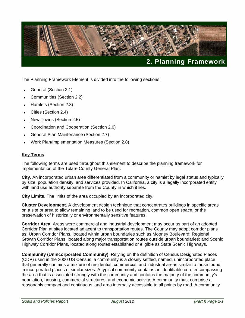
Goals and Policies Report August 2012 (Part I) Page 2-1 2. Planning Framework The Planning Framework Element is divided into the following sections: General (Section 2.1) Communities (Section 2.2) Hamlets (Section 2.3) Cities (Section 2.4) New Towns (Section 2.5) Coordination and Cooperation (Section 2.6) General Plan Maintenance (Section 2.7) Work Plan/Implementation Measures (Section 2.8) Key Terms The following terms are used throughout this element to describe the planning framework for implementation of the Tulare County General Plan: City. An incorporated urban area differentiated from a community or hamlet by legal status and typically by size, population density, and services provided. In California, a city is a legally incorporated entity with land use authority separate from the County in which it lies. City Limits. The limits of the area occupied by an incorporated city. Cluster Development. A development design technique that concentrates buildings in specific areas on a site or area to allow remaining land to be used for recreation, common open space, or the preservation of historically or environmentally sensitive features. Corridor Area. Areas were commercial and industrial development may occur as part of an adopted Corridor Plan at sites located adjacent to transportation routes. The County may adopt corridor plans as: Urban Corridor Plans, located within urban boundaries such as Mooney Boulevard; Regional Growth Corridor Plans, located along major transportation routes outside urban boundaries; and Scenic Highway Corridor Plans, located along routes established or eligible as State Scenic Highways. Community (Unincorporated Community). Relying on the definition of Census Designated Places (CDP) used in the 2000 US Census, a community is a closely settled, named, unincorporated place that generally contains a mixture of residential, commercial, and industrial areas similar to those found in incorporated places of similar sizes. A typical community contains an identifiable core encompassing the area that is associated strongly with the community and contains the majority of the community’s population, housing, commercial structures, and economic activity. A community must comprise a reasonably compact and continuous land area internally accessible to all points by road. A community
Transcript of 2. Planning Framework - Tulare County General Plan...
Goals and Policies Report August 2012 (Part I) Page 2-1
2. Planning Framework The Planning Framework Element is divided into the following sections:
General (Section 2.1)
Communities (Section 2.2)
Hamlets (Section 2.3)
Cities (Section 2.4)
New Towns (Section 2.5)
Coordination and Cooperation (Section 2.6)
General Plan Maintenance (Section 2.7)
Work Plan/Implementation Measures (Section 2.8)
Key Terms The following terms are used throughout this element to describe the planning framework for implementation of the Tulare County General Plan: City. An incorporated urban area differentiated from a community or hamlet by legal status and typically by size, population density, and services provided. In California, a city is a legally incorporated entity with land use authority separate from the County in which it lies. City Limits. The limits of the area occupied by an incorporated city. Cluster Development. A development design technique that concentrates buildings in specific areas on a site or area to allow remaining land to be used for recreation, common open space, or the preservation of historically or environmentally sensitive features. Corridor Area. Areas were commercial and industrial development may occur as part of an adopted Corridor Plan at sites located adjacent to transportation routes. The County may adopt corridor plans as: Urban Corridor Plans, located within urban boundaries such as Mooney Boulevard; Regional Growth Corridor Plans, located along major transportation routes outside urban boundaries; and Scenic Highway Corridor Plans, located along routes established or eligible as State Scenic Highways. Community (Unincorporated Community). Relying on the definition of Census Designated Places (CDP) used in the 2000 US Census, a community is a closely settled, named, unincorporated place that generally contains a mixture of residential, commercial, and industrial areas similar to those found in incorporated places of similar sizes. A typical community contains an identifiable core encompassing the area that is associated strongly with the community and contains the majority of the community’s population, housing, commercial structures, and economic activity. A community must comprise a reasonably compact and continuous land area internally accessible to all points by road. A community
T u l a r e C o u n t y G e n e r a l P l a n
(Part I) Page 2-2 August 2012 Goals and Policies Report
encompasses the surrounding closely settled territory associated with the place name. There are generally no minimum or maximum population thresholds for recognition as a community. County Adopted City (CAC) General Plan. A Plan that the County adopts to govern land use decisions of the County between the city limits, the UAB of the city, and unincorporated areas of the County. Development Standards. Regulations including but not limited to setbacks, landscaping, screening, height, site coverage, signs, building layout, parking, site design, and related features of land use. Foothill Region. The Foothill Region of Tulare County includes geographical areas generally above the 600-foot elevation line, and is bounded on the east by the federally-owned parks in the Sierra Nevada Mountains. Hamlet. An unincorporated area that shares many of the characteristics of a community but on a smaller scale. The following criteria are used to define an unincorporated area as a “hamlet” for purposes of the General Plan:
1. Generally located in the Valley region of the County but may be located in the Foothill region, and should be identified in the Foothill Growth Management Plan,
2. A population of over 100 persons,
3. The population resides in the area more than nine months out of the year, and
4. A definable core that contains at least three of the following features:
a. Special district or town council,
b. Grocery store or other commercial establishment,
c. Wastewater system,
d. Community water system,
e. Public school,
f. Post office, and
g. Community center or other community gathering location (church, Veterans Memorial Hall, etc.) No hamlets are identified in the Foothill region of the County during this General Plan Update. Hamlet Development Boundary (HDB). This is an officially adopted and mapped County line around a hamlet that divides lands suitable for development from lands to be protected for agricultural, natural, or rural uses. Land inside a HDB is appropriate for development and is not subject to the criteria evaluation of development as established in the Rural Valley Lands Plan or Foothill Growth Management Plan [RVLP Policy 1-1]. Mountain Region. This geographical area included all lands located east of the Foothill Region which generally coincided with the western boundary of federal lands. Neighborhoods. Existing urban type uses and subdivisions that currently exist within a County Adopted City Urban Development Boundary (CACUDB) and County Adopted City Urban Area Boundary (CACUAB). Many of these neighborhoods do not have formal plans but are planned for within the associated County Adopted City General Plan. Two of the largest Neighborhoods are
2 . P l a n n i n g F r a m e w o r k
Goals and Policies Report August 2012 (Part I) Page 2-3
Patterson Tract and East Porterville, however, there are many smaller ones, including but not limited to, Rancho Sierra, Tooleville, Cameron Creek, and Oak Ranch. New Town (Planned Community). A new, large, mixed use community in the unincorporated portion of the County containing housing, commercial, employment, and community support uses. Once a new town has completed its development in accordance with its approved entitlements and the area has become a “built-out” and established settled place that contains a mixture of residential, commercial, and industrial development, the area, will be designated as a Community as defined above. Other Unincorporated. Unincorporated portions of the County that are not within the Urban Area Boundaries (UABs) associated with cities, the Urban Development Boundaries (UDBs) of communities, Hamlet Development Boundaries (HDBs) of hamlets, or Planned Community Areas (PCAs). Rural (Non-Agricultural) Development. Development that is generally characterized by very low density residential development (1 to 5 acre parcels) that is not necessarily limited to agricultural or other resource uses. Sphere of Influence (SOI). The Local Agency Formation Commission (LAFCo) in every County adopts a SOI for each city to represent “the probable physical boundaries and service area” of that city (Government Code §56076). LAFCo also adopts SOI for most special districts. In most instances, the Sphere of Influence (SOI) and the Urban Development Boundary (UDB) may be coterminous. Urban Area Boundary (UAB). This is an officially adopted and mapped County line around incorporated cities. The hierarchy is as follows: incorporated city limits, Urban Development Boundary (may be coterminous with the Sphere of Influence adopted by LAFCo), and the Urban Area Boundary of an incorporated city. The UABs establish areas (the area between the UDB and UAB) around incorporated cities where the County and cities may coordinate plans and policies relating to street and highway construction, public utility systems, and future right of way preservation, affecting the orderly development of urban fringe areas. Urban Development. Development generally characterized by low to high density residential development, commercial development, industrial development, and typically supported by public services such as central water and sewer systems. Urban Development Boundary (UDB). For cities, the County Adopted City UDB is an officially adopted and mapped County line delineating the area expected for urban growth over a 20-year period. This line may be coterminous to the Local Agency Formation Commissions Sphere of Influence. Land within a County Adopted City UDB may be appropriate for development. For unincorporated communities, the UDB is a County adopted line dividing land to be developed from land to be protected for agricultural, natural, open space, or rural uses. It serves as the official planning area for communities over a 20 year period. Land within an unincorporated UDB is assumed appropriate for development and is not subject to the Rural Valley Lands Plan or Foothill Growth Management Plan [RVLP Policy 1-1]. Valley Region. The Valley Region is the geographical area generally below the 600-foot elevation contour line. Existing Conditions Overview In the past, the County used three key planning tools to guide urban development in all unincorporated areas of the County. The first was the Urban Boundaries Element; the second are the Area Plans; the third are the General Plans for identified incorporated cities and Community Plans for unincorporated communities. For discussion of the Area Plans which include the Rural Valley Lands Plan, Corridors Framework Plan, Foothill Growth Management Plan, and Mountain Framework Plan, please see Part II.
T u l a r e C o u n t y G e n e r a l P l a n
(Part I) Page 2-4 August 2012 Goals and Policies Report
The Urban Boundaries Element, first adopted in 1974, identified two types of boundaries: Urban Area Boundaries (UABs) and Urban Improvement Areas (UIAs). At the time of the Urban Boundaries Element adoption, the UIAs were defined as the twenty-year growth boundaries and the UABs were defined as the ultimate growth boundary for each city and community. In 1983, the Urban Boundaries Element was amended to replace the UIAs with UDBs, and to modify the UAB model to include a “comment” area around incorporated cities, keeping UABs as the next logical area for urban expansion. In addition, UABs were no longer established around unincorporated communities. The UDB lines established a twenty-year growth boundary for unincorporated communities for which services will likely be extended to allow new urban growth. The County used population, existing County policies, and a development suitability analysis to determine the location and size of the community UDBs. The Urban Boundaries Element directed that community plans be adopted for 22 unincorporated communities to guide future development within their community boundaries. Of the 22 communities identified by the element, 15 had adopted Community Plans by mid-2004. Three of the Community Plans contain plans for two communities. Community Plans supplement County-wide General Plan policies. These plans have their own Land Use Diagrams and circulation plans, and include land use designations and development standards to guide area growth. Communities with plans as of 2009 are as follows: Cutler-Orosi Community Plan (1988)
Earlimart Community Plan (1988)
Goshen Community Plan (1978)
Ivanhoe Community Plan (1990)
Pixley Community Plan (1997)
Poplar-Cotton Center Community Plan (1996)
Richgrove Community Plan (1986)
Springville Community Plan (1985)
Strathmore Community Plan (1989)
Terra Bella-Ducor Community Plan (2004)
Three Rivers Community Plan (1980)
Traver Community Plan (1989) In 2012, several communities did not have adopted community plans. Under the prior General Plan, UDBs were established during the General Plan Amendment process. These communities had a UAB or UIA until such time that the UDB was established. Under this General Plan update, the UDB for each community is established under Policy PF-2.1: Urban Development Boundaries-Communities. Older UAB or UIA lines for the communities are converted to UDBs. These communities typically have urban uses, urban zoning, and urban infrastructure as intended by the 1974 Urban Boundaries Element. Until such time as a Community Plan is adopted, the land use designation shall be Mixed Use as per policy PF 2.6: Land Use Consistency. These communities are as follows:
Alpaugh
East Orosi
Lemon Cove
London
2 . P l a n n i n g F r a m e w o r k
Goals and Policies Report August 2012 (Part I) Page 2-5
Plainview
Tipton
Woodville
The County has adopted County Adopted City General Plans for all eight incorporated cities to guide County land use decisions outside the city limits within the County UDB and UAB. The eight incorporated cities are: Dinuba
Exeter
Farmersville
Lindsay
Porterville
Tulare
Visalia
Woodlake
Two areas adjacent to cities located outside of the County currently have UDBs but no adopted plans at this time. Until such time as a plan is adopted the land use designation shall be mixed use. These areas are adjacent to the following cities located outside of the County: Delano
Kingsburg
The County has recognized certain existing neighborhoods within the Urban Area Boundaries of certain cities. It is anticipated that these neighborhoods will be annexed or that municipal services will be provided to these areas at an appropriate time in the future. Two of these neighborhoods have their own UDBs and are currently able to develop to urban uses with urban standards. These neighborhoods include: East Porterville
Patterson Tract
T u l a r e C o u n t y G e n e r a l P l a n
(Part I) Page 2-6 August 2012 Goals and Policies Report
2 . P l a n n i n g F r a m e w o r k
Goals and Policies Report August 2012 (Part I) Page 2-7
2.1 General
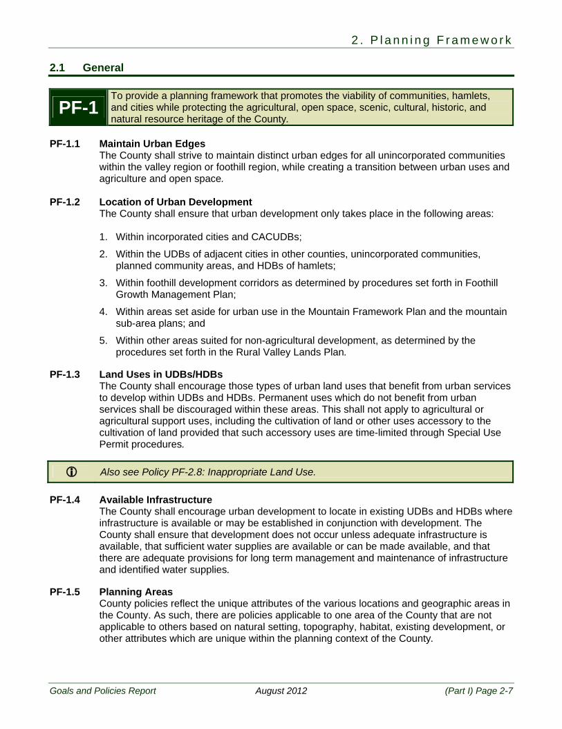
PF-1 To provide a planning framework that promotes the viability of communities, hamlets, and cities while protecting the agricultural, open space, scenic, cultural, historic, and natural resource heritage of the County.
PF-1.1 Maintain Urban Edges
The County shall strive to maintain distinct urban edges for all unincorporated communities within the valley region or foothill region, while creating a transition between urban uses and agriculture and open space.
PF-1.2 Location of Urban Development
The County shall ensure that urban development only takes place in the following areas:
1. Within incorporated cities and CACUDBs;
2. Within the UDBs of adjacent cities in other counties, unincorporated communities, planned community areas, and HDBs of hamlets;
3. Within foothill development corridors as determined by procedures set forth in Foothill Growth Management Plan;
4. Within areas set aside for urban use in the Mountain Framework Plan and the mountain sub-area plans; and
5. Within other areas suited for non-agricultural development, as determined by the procedures set forth in the Rural Valley Lands Plan.
PF-1.3 Land Uses in UDBs/HDBs
The County shall encourage those types of urban land uses that benefit from urban services to develop within UDBs and HDBs. Permanent uses which do not benefit from urban services shall be discouraged within these areas. This shall not apply to agricultural or agricultural support uses, including the cultivation of land or other uses accessory to the cultivation of land provided that such accessory uses are time-limited through Special Use Permit procedures.
Also see Policy PF-2.8: Inappropriate Land Use. PF-1.4 Available Infrastructure
The County shall encourage urban development to locate in existing UDBs and HDBs where infrastructure is available or may be established in conjunction with development. The County shall ensure that development does not occur unless adequate infrastructure is available, that sufficient water supplies are available or can be made available, and that there are adequate provisions for long term management and maintenance of infrastructure and identified water supplies.
PF-1.5 Planning Areas
County policies reflect the unique attributes of the various locations and geographic areas in the County. As such, there are policies applicable to one area of the County that are not applicable to others based on natural setting, topography, habitat, existing development, or other attributes which are unique within the planning context of the County.
T u l a r e C o u n t y G e n e r a l P l a n
(Part I) Page 2-8 August 2012 Goals and Policies Report
PF-1.6 Appropriate Land Uses by Location The County shall utilize the Land Use Element and adopted CAC General Plans, Community Plans, Hamlet Plans, Planned Communities, Corridor Areas, or Area Plans to designate land uses and intensities that reflect and maintain the appropriate level of urbanized development in each CAC General Plan, Community Plan, Hamlet Plan, Planned Community, Corridor Area, or Area Plan.
PF-1.7 Census Boundaries
The County shall work with TCAG and the U.S. Census Bureau to ensure that the Census data geography matches adopted UDBs, UABs, and HDBs.
PF-1.8 Special District Boundaries
In areas where special districts provide rural, as well as urban services, the County shall work with LAFCo to distinguish between “urban” and “rural” service areas for the purpose of establishing spheres of influence for such districts. If an unincorporated community is served by a special district, the UDB or HDB should be consistent with the district’s “urban” sphere of influence.
PF-1.9 Capacity Building and Self Governance
The County shall encourage the residents in unincorporated communities, as defined, to be actively involved in self governance. This includes:
1. Establishment of local advisory boards to facilitate the development and maintenance of community and hamlet plans,
2. Providing for local input on development applications as part of the County’s review process,
3. Expanding local empowerment through expanding the authorized powers of County service areas and community service districts, and
4. Supporting the incorporation of unincorporated communities when determined through the LAFCo process to be fiscally sound.
PF-1.10 Non-Conforming Uses – General
Any previously or legally established use, building, or parcel that may not be expressly permitted by this plan in any given land use designation or the implementing zoning shall be allowed to continue in accordance with the Tulare County Zoning Ordinance and General Plan.
PF-1.11 Interpretation of Boundaries
The County shall utilize standardized rules for reviewing and adopting boundaries for Unincorporated Community Plans, CAC General Plans, and other plan types.
2 . P l a n n i n g F r a m e w o r k
Goals and Policies Report August 2012 (Part I) Page 2-9
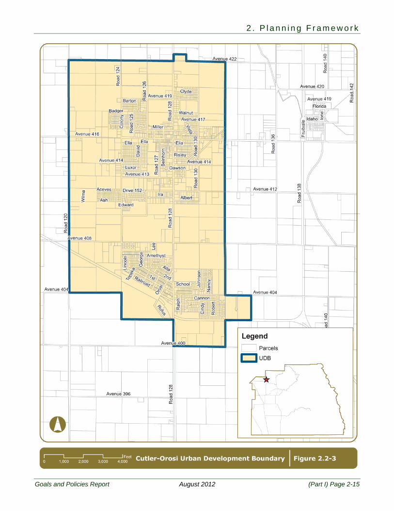
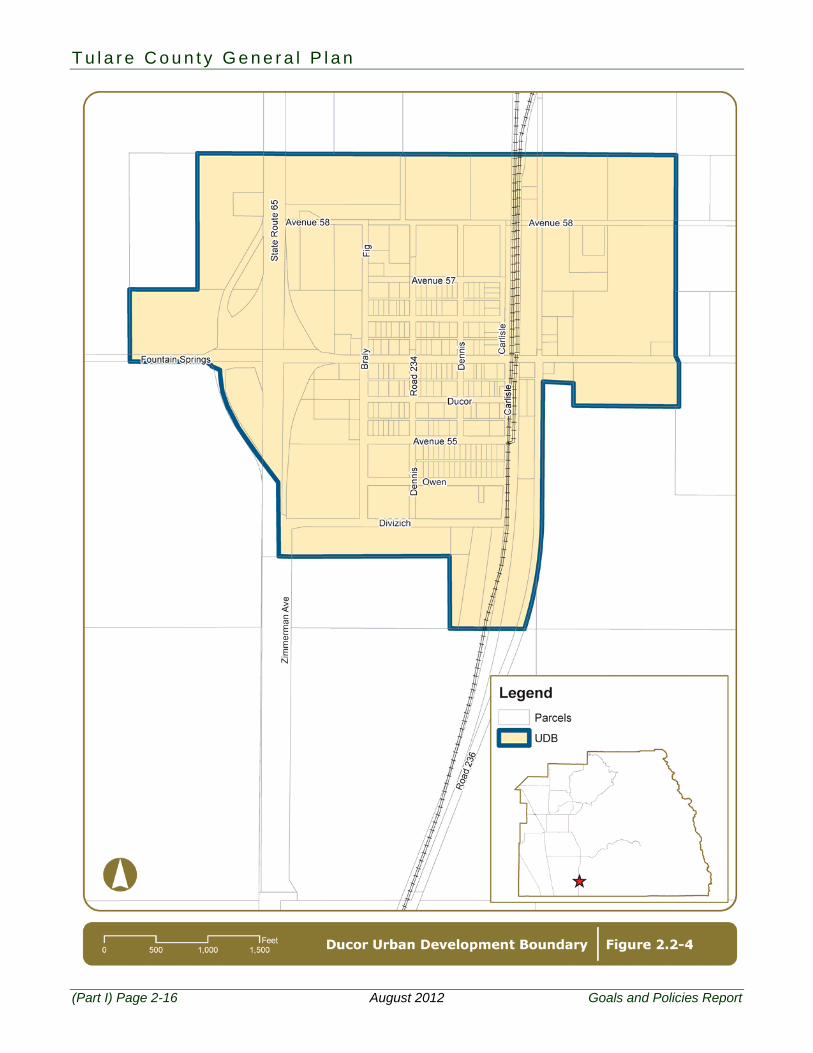
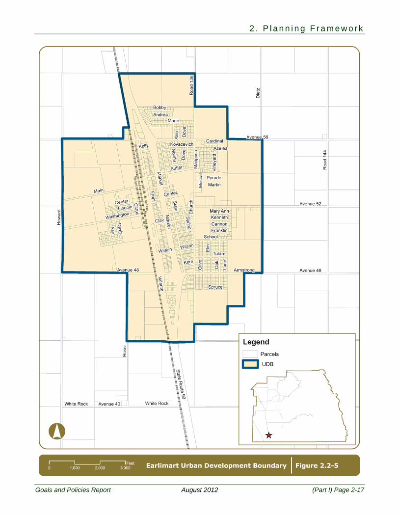
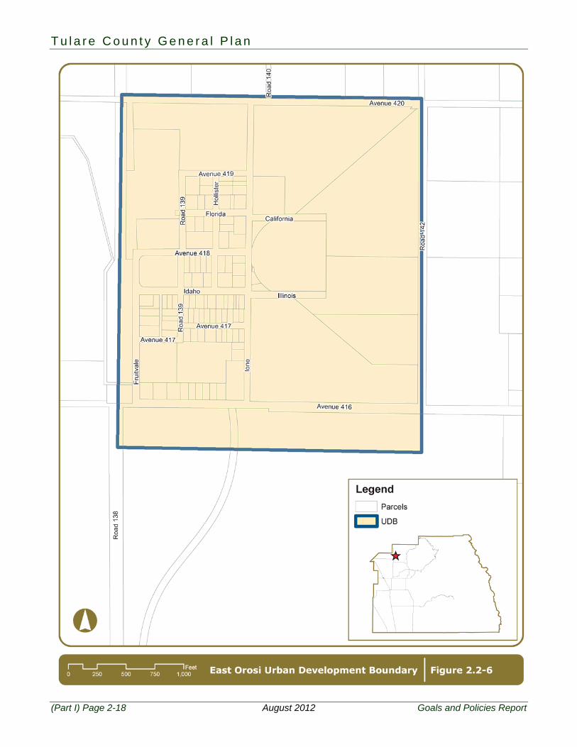
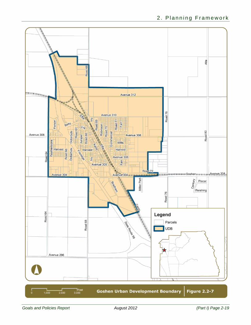
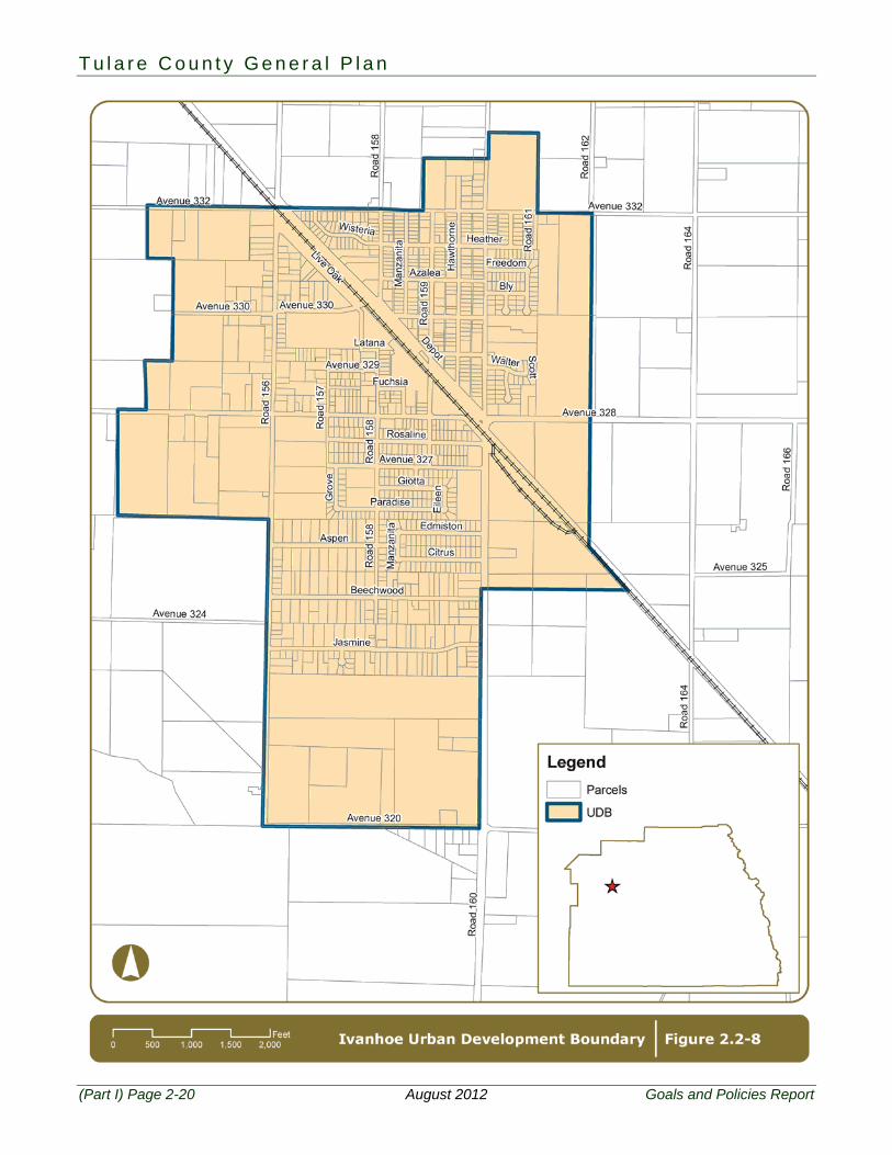
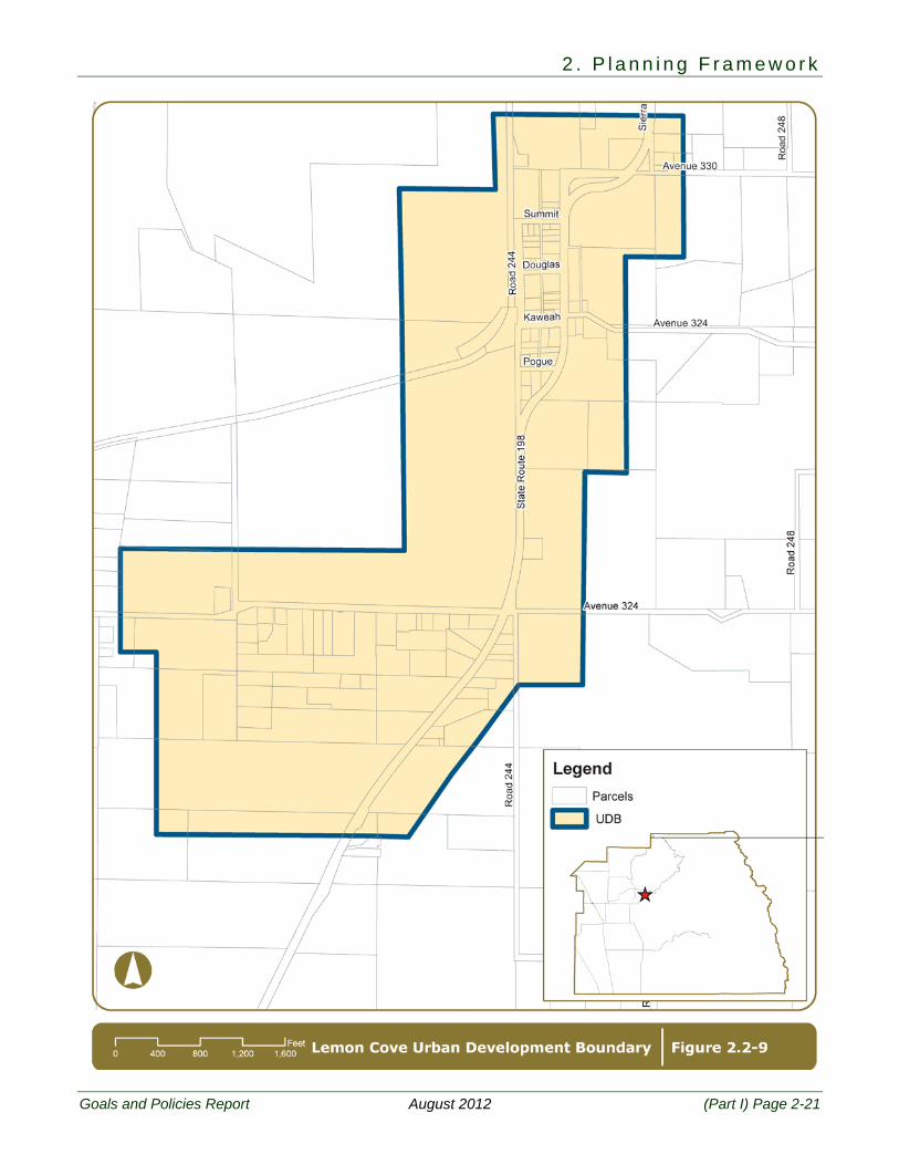
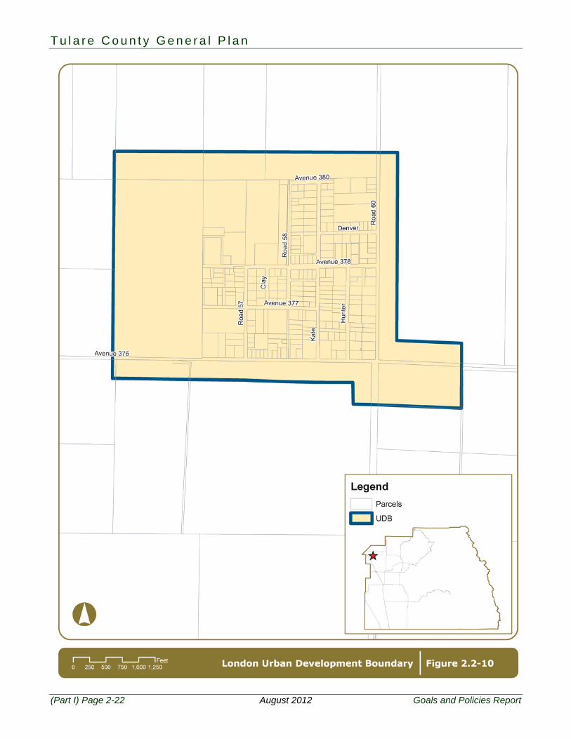
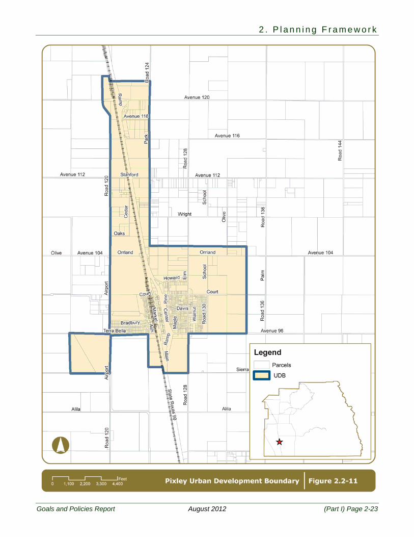
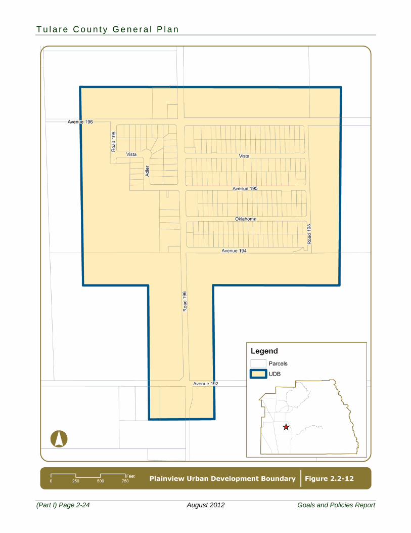
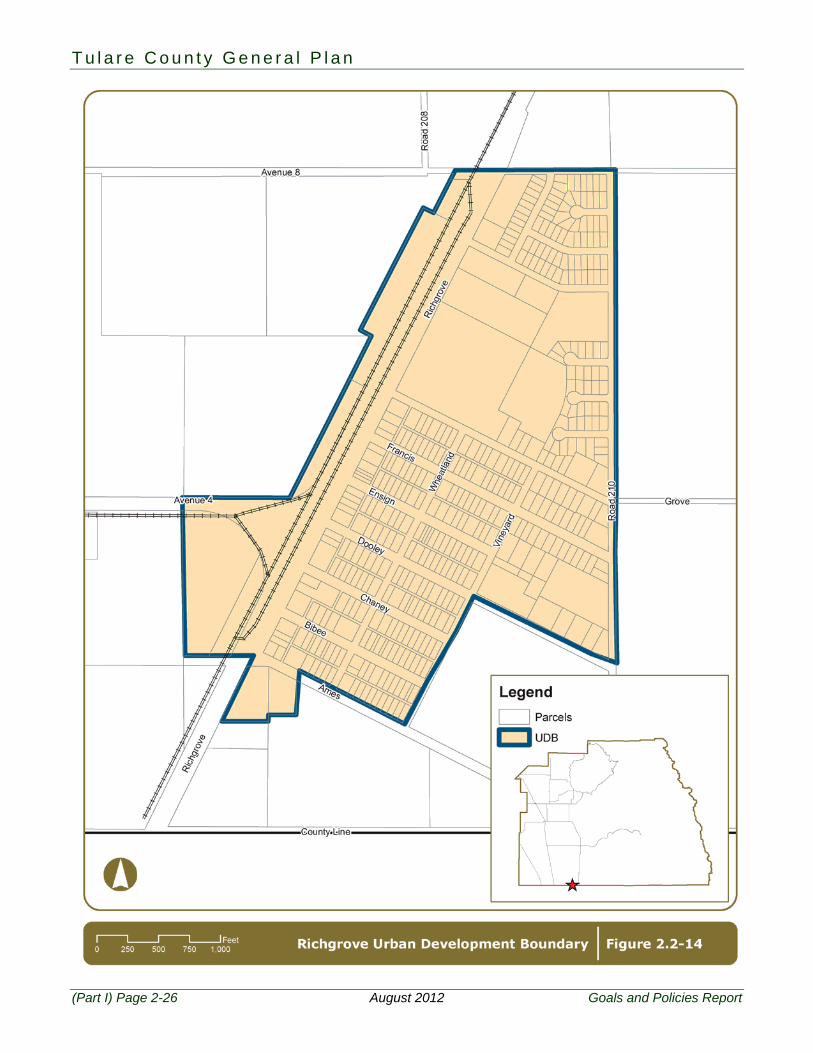
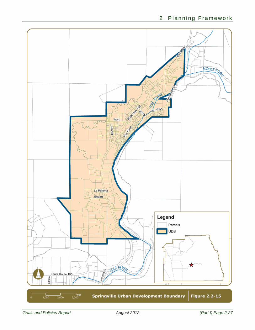
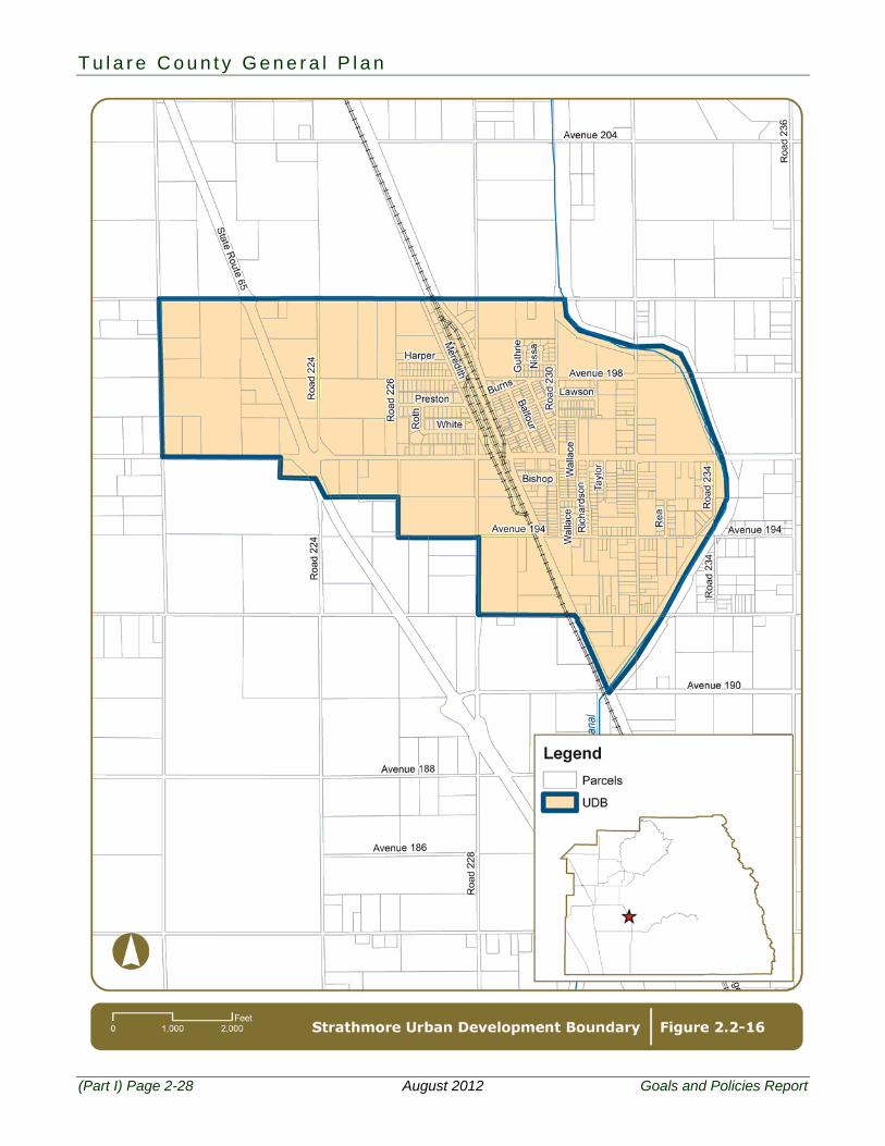
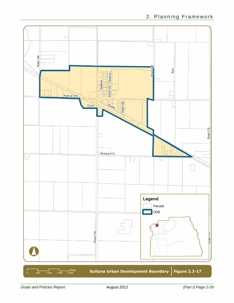
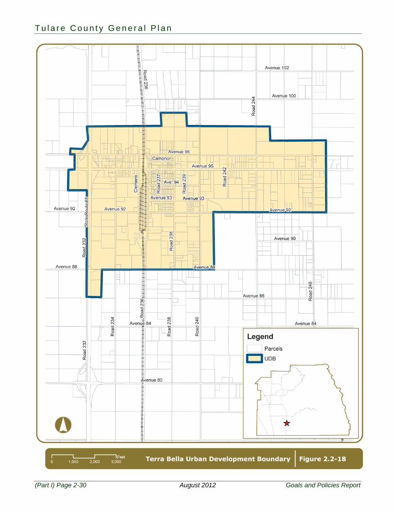
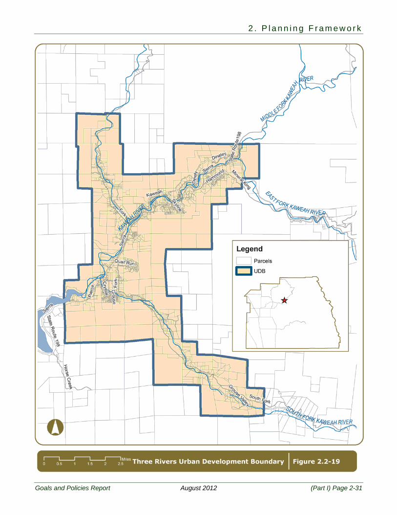
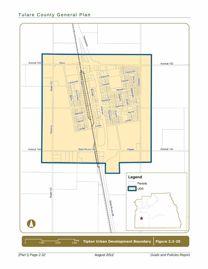
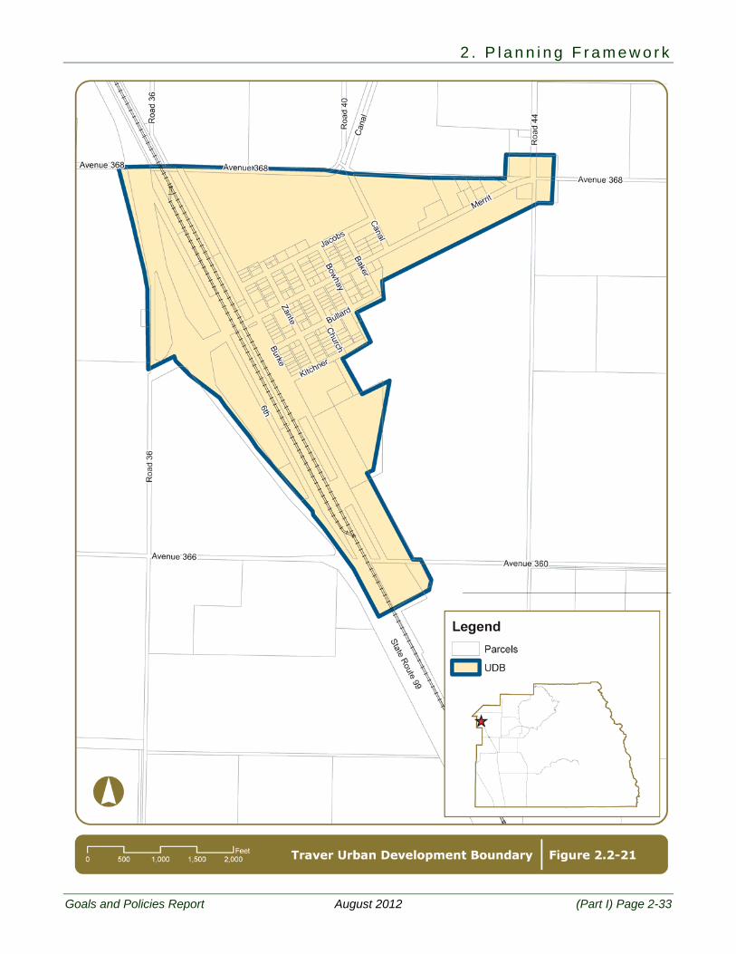
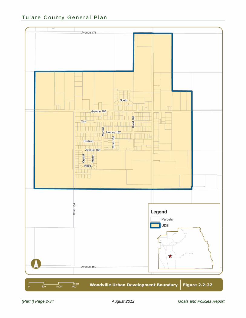
2.2 Communities Figure 2.2-1 shows the locations of all twenty one unincorporated Communities within Tulare County and Figures 2.2-2 through 2.2-22 show the County’s UDBs adopted for each Community:
Alpaugh Cutler/Orosi Ducor Earlimart East Orosi Goshen Ivanhoe Lemon Cove London Pixley Plainview
Poplar/Cotton Center
Richgrove Springville Strathmore Sultana Terra Bella Three Rivers Tipton Traver Woodville
PF-2 To provide a realistic planning area around each unincorporated community that clearly delineates the boundaries of each community and provides a framework for economic development, the provision of public services, and an outstanding quality of life.
PF-2.1 Urban Development Boundaries – Communities
The County shall limit urban development to the area within the designated UDB for each community. Each community’s UDB is defined as shown on Figures 2.2-2 thru 2.2-22.
PF-2.2 Modification of Community UDB
1. The County may consider modification to a community UDB under any of, but not limited to the following circumstances:
a. The location of the UDB shall be evaluated during preparation or update of a community plan.
b. All community UDBs should be reviewed on a five-year cycle to reflect changes in growth and development patterns.
c. A request for expansion of the UDB boundary can be applied for as part of a General Plan Amendment to the Land Use Diagram.
d. At the request of a special district or the community.
e. A UDB should be considered for expansion at such time as land for infill becomes limited. This condition is considered satisfied when 80 percent of the non-Williamson Act land within the UDB is developed for urban uses.
f. UDBs should not be expanded onto Prime Farmland if Farmland of Statewide Importance or of lesser quality is available and suitable for expansion.
2. Prior to approval of a UDB boundary expansion, the County shall ensure that infrastructure can be provided to serve the new areas added to the UDB and that sufficient water supplies are also available. This may require preparation of an infrastructure master plan that includes methods of financing of improvements and maintenance, as well as representation/documentation of availability and sufficiency of long-term water supplies.
T u l a r e C o u n t y G e n e r a l P l a n
(Part I) Page 2-10 August 2012 Goals and Policies Report
3. Preservation of productive agricultural lands shall be the highest priority when considering modifications. Expansion of a UDB to include additional agricultural land shall only be allowed when other non-agricultural lands are not reasonably available to the community or are not suitable for expansion.
PF-2.3 UDB and Other Boundaries
The County shall provide notice and opportunity for special districts, school districts, and other service providers when evaluating the expansion of a Community’s UDB.
PF-2.4 Community Plans
The County shall ensure that community plans are prepared, updated, and maintained for each of the communities. These plans shall include the entire area within the community’s UDB and shall address the community’s short and long term ability to provide necessary urban services.
See Table 2.1: Community Plan Content for components of a Community Plan.
PF-2.5 Collaborative Community Planning Partnerships
The County should encourage establishment of collaborative partnerships for preparation of a community plan updates where one or more applicants are willing to fund the update, regardless of the position of the community on the community plan priority list. Requirements for new town development shall be utilized to guide such private/public joint planning efforts.
PF-2.6 Land Use Consistency
The County shall require all community plans, when updated, to use the same land use designations as used in this Countywide General Plan (See Chapter 4-Land Use). All community plans shall also utilize a similar format and content. The content may change due to the new requirements such as Global Climate Change and Livable Community Concepts, as described on the table provided (Table 2.1: Community Plan Content). Changes to this format may be considered for unique and special circumstances as determined appropriate by the County. Until such time as a Community Plan is adopted for those communities without existing Community Plans, the land use designation shall be Mixed Use, which promotes the integration of a compatible mix of residential types and densities, commercial uses, public facilities, and services and employment opportunities.
PF-2.7 Improvement Standards in Communities
The County shall require development within the designated UDBs to meet an urban standard for improvements. Typical improvements shall include curbs, gutters, sidewalks, and community sewer and water systems.
PF-2.8 Inappropriate Land Use
Areas within UDBs are hereby set aside for those types of urban land uses which benefit from urban services. Permanent uses which do not benefit from such urban services shall be discouraged within the UDBs. This is not intended to apply to agricultural or agricultural supported uses, including the cultivation of land or other uses accessory to the cultivation of land, provided that such accessory uses are time-limited through special use permit procedures.
Also see Policy PF-1.3: Land Uses in UDBs/HDBs.
2 . P l a n n i n g F r a m e w o r k
Goals and Policies Report August 2012 (Part I) Page 2-11
PF-2.9 Zoning in Communities The County shall maintain zoning that is consistent with the adopted Community Plan Land Use Diagram in accordance with California Code § 65103.
PF-2.10 Valley Urban Improvement Areas and Urban Area Boundaries
All UIAs established in the 1974 Urban Boundaries Element, and UABs for valley communities, are hereby converted to UDBs.
Text continues on Page 2-35.
T u l a r e C o u n t y G e n e r a l P l a n
(Part I) Page 2-12 August 2012 Goals and Policies Report
Table 2.1
Community Plan Content (Policy PF-2.4: Community Plans) 1. Introduction
Introduction Planning Framework The Need for a Community Plan
2. Policy Plan
Purpose Community Involvement Redevelopment Land Use Circulation (including pedestrian, cyclist
and transit facilities) Community Design Housing Commerce Industry Agriculture Schools Libraries Parks and Open Space Fire Protection and Law Enforcement Public Facilities (sewer, water, drainage) Noise General Plan Consistency Infrastructure, Urban Improvement
Standards, and Development Standards Financing Plan (including funding
mechanisms to cover capital costs as well as long-term operations and maintenance for roadways and all other public infrastructure, services, and facilities)
3. Urban Development Boundary
Establishment Methodology Projections County Policy Development Suitability Recommended Boundary
4. Community Profile (Existing Conditions) Planning Area
• Location • Land Use Planning • Land Use • Existing Zoning • Population • Projected Population • Age of Structures • Ethnicity and Other Socioeconomic
Characteristics Housing
• Types • Tenure • Conditions • Overcrowding • Infill Opportunities • Vacancy • Affordability
Economy • Employment • Income
Public Services • Police • Fire • Schools
Infrastructure • Sewer • Water • Drainage
Circulation Cultural and Natural Resources
• Soils • Agriculture • Air Quality • Water • Flooding • Drainage • Noise • Seismic/Geologic Hazards • Historic Sites
County Policy 5. Plan Performance
2 . P l a n n i n g F r a m e w o r k
Goals and Policies Report August 2012 (Part I) Page 2-13
T u l a r e C o u n t y G e n e r a l P l a n
(Part I) Page 2-14 August 2012 Goals and Policies Report
2 . P l a n n i n g F r a m e w o r k
Goals and Policies Report August 2012 (Part I) Page 2-15
T u l a r e C o u n t y G e n e r a l P l a n
(Part I) Page 2-16 August 2012 Goals and Policies Report
2 . P l a n n i n g F r a m e w o r k
Goals and Policies Report August 2012 (Part I) Page 2-17
T u l a r e C o u n t y G e n e r a l P l a n
(Part I) Page 2-18 August 2012 Goals and Policies Report
2 . P l a n n i n g F r a m e w o r k
Goals and Policies Report August 2012 (Part I) Page 2-19
T u l a r e C o u n t y G e n e r a l P l a n
(Part I) Page 2-20 August 2012 Goals and Policies Report
2 . P l a n n i n g F r a m e w o r k
Goals and Policies Report August 2012 (Part I) Page 2-21
T u l a r e C o u n t y G e n e r a l P l a n
(Part I) Page 2-22 August 2012 Goals and Policies Report
2 . P l a n n i n g F r a m e w o r k
Goals and Policies Report August 2012 (Part I) Page 2-23
T u l a r e C o u n t y G e n e r a l P l a n
(Part I) Page 2-24 August 2012 Goals and Policies Report

2 . P l a n n i n g F r a m e w o r k
Goals and Policies Report August 2012 (Part I) Page 2-25
T u l a r e C o u n t y G e n e r a l P l a n
(Part I) Page 2-26 August 2012 Goals and Policies Report
2 . P l a n n i n g F r a m e w o r k
Goals and Policies Report August 2012 (Part I) Page 2-27
T u l a r e C o u n t y G e n e r a l P l a n
(Part I) Page 2-28 August 2012 Goals and Policies Report
2 . P l a n n i n g F r a m e w o r k
Goals and Policies Report August 2012 (Part I) Page 2-29
T u l a r e C o u n t y G e n e r a l P l a n
(Part I) Page 2-30 August 2012 Goals and Policies Report
2 . P l a n n i n g F r a m e w o r k
Goals and Policies Report August 2012 (Part I) Page 2-31
T u l a r e C o u n t y G e n e r a l P l a n
(Part I) Page 2-32 August 2012 Goals and Policies Report
2 . P l a n n i n g F r a m e w o r k
Goals and Policies Report August 2012 (Part I) Page 2-33
T u l a r e C o u n t y G e n e r a l P l a n
(Part I) Page 2-34 August 2012 Goals and Policies Report
2 . P l a n n i n g F r a m e w o r k
Goals and Policies Report August 2012 (Part I) Page 2-35
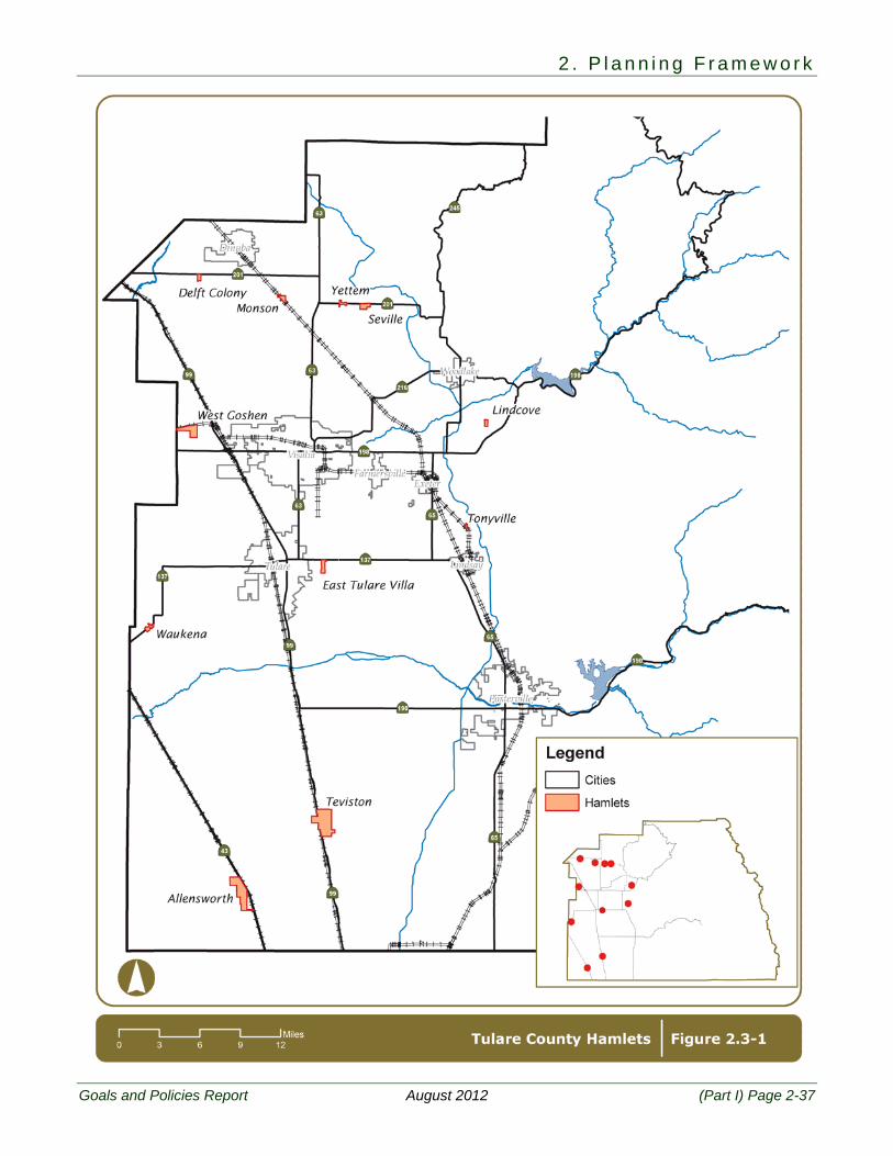
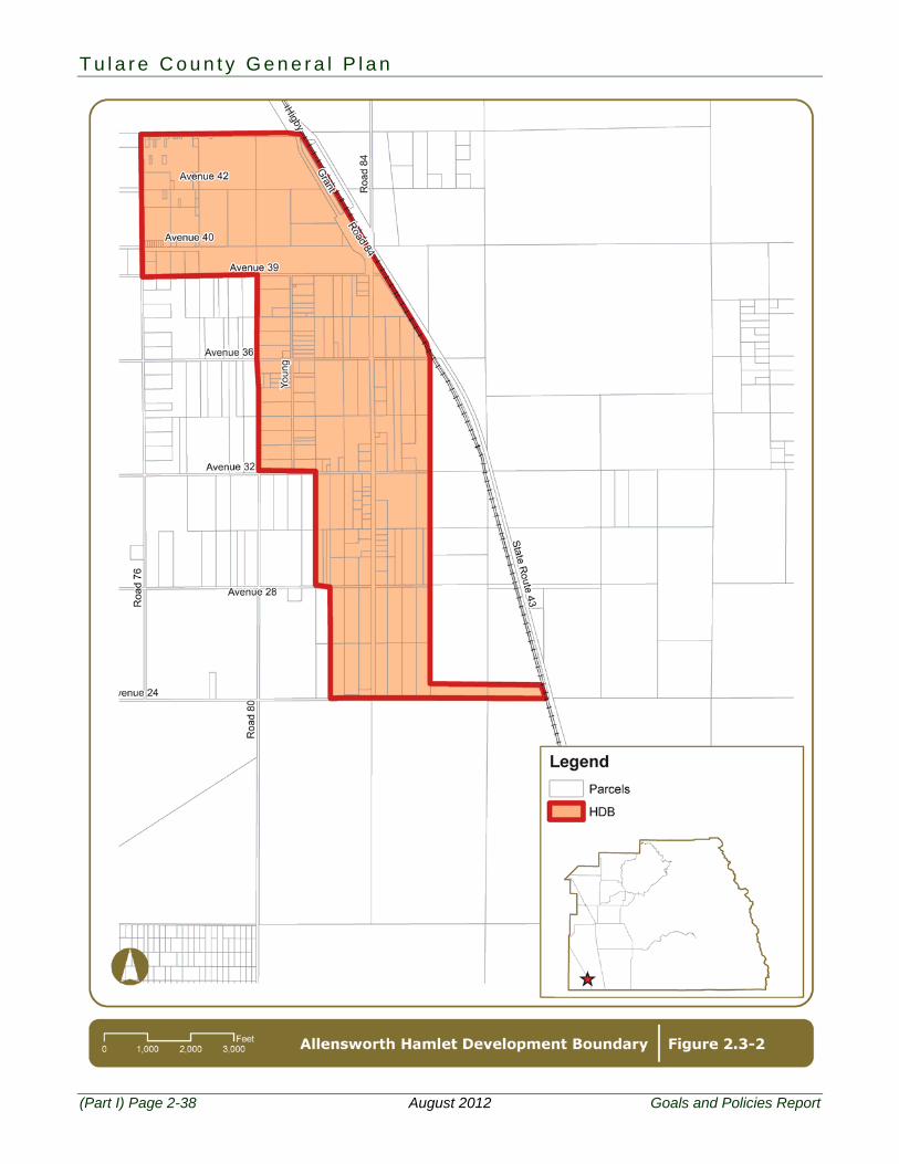
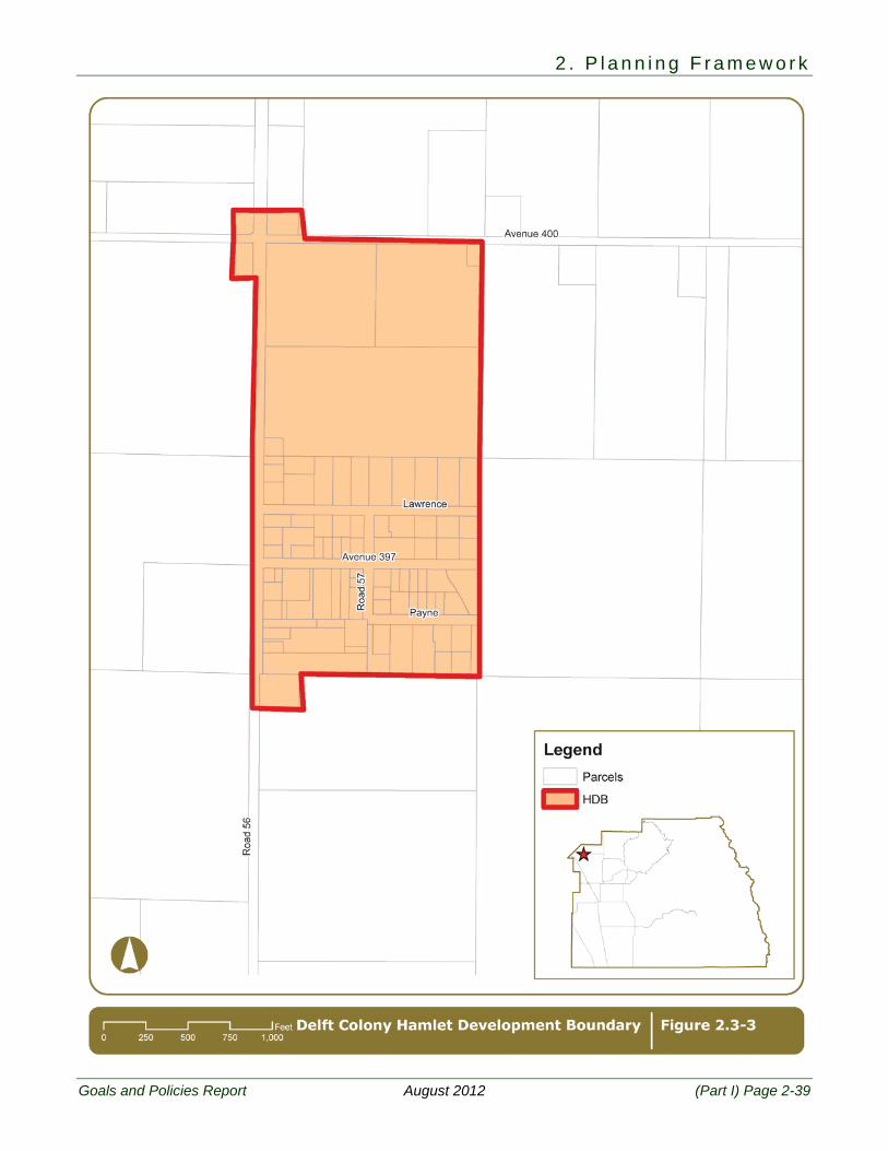
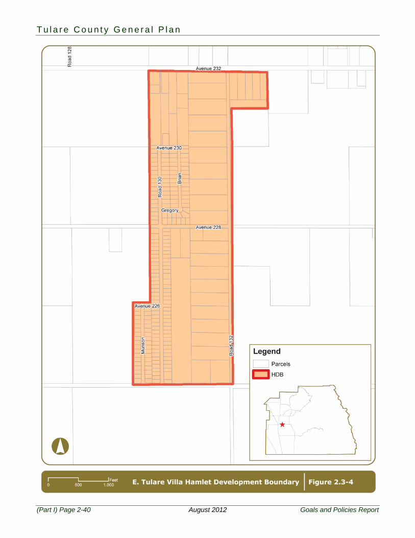
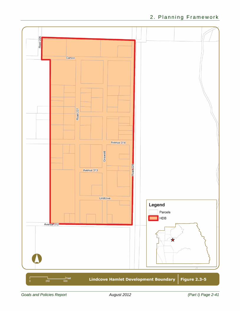
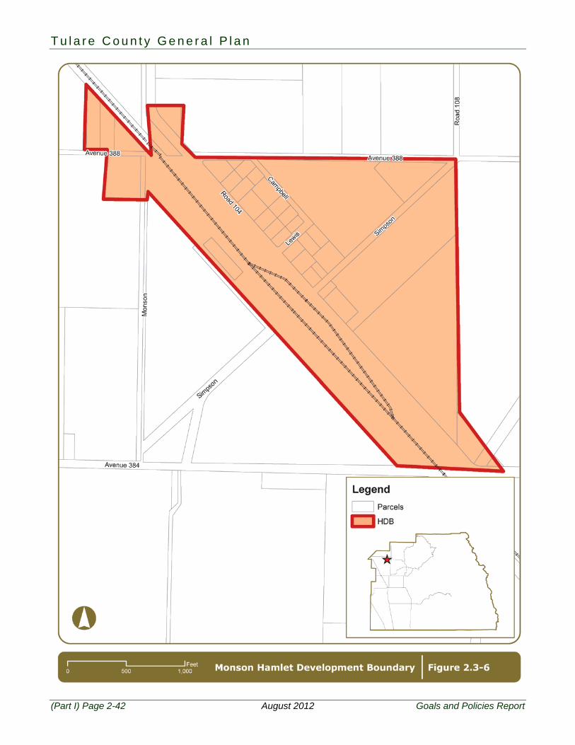
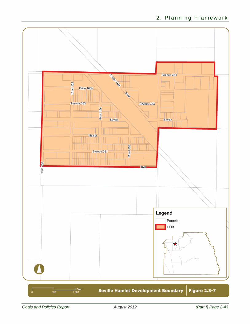
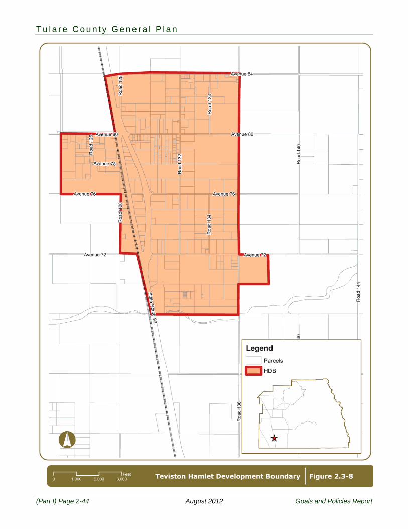
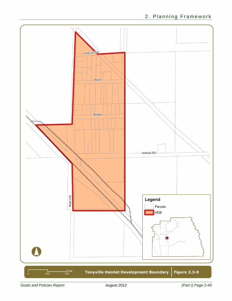
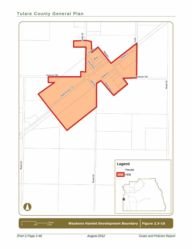
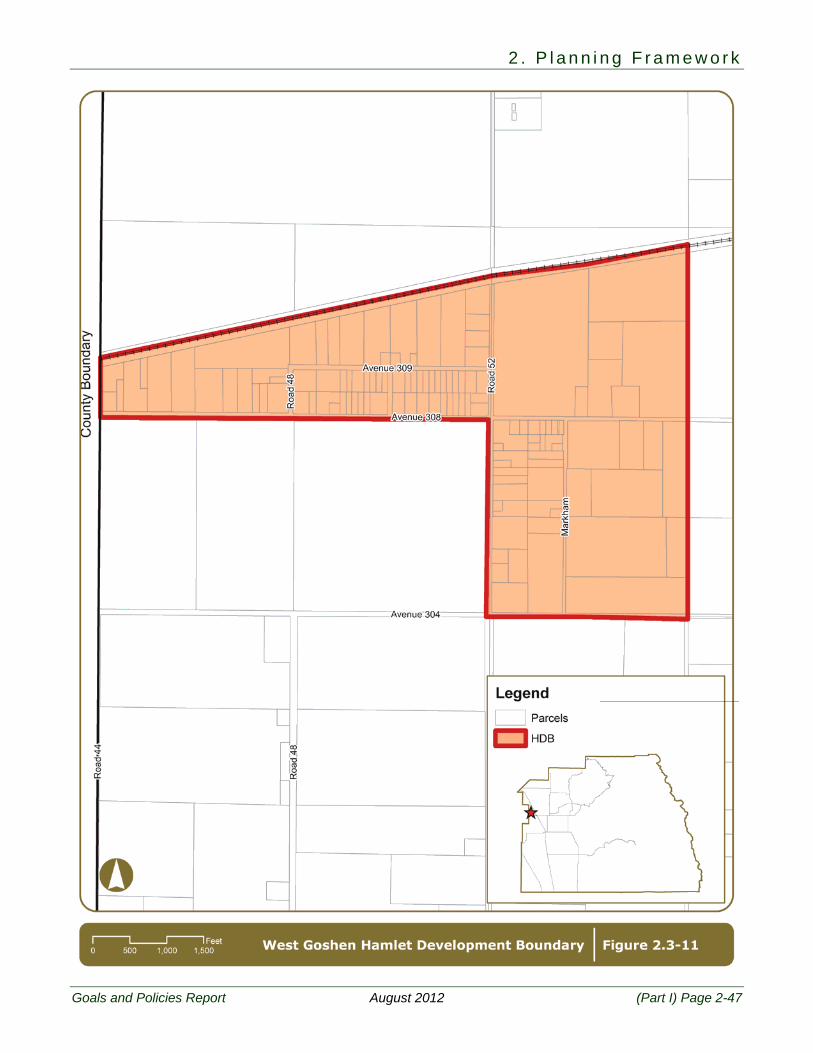
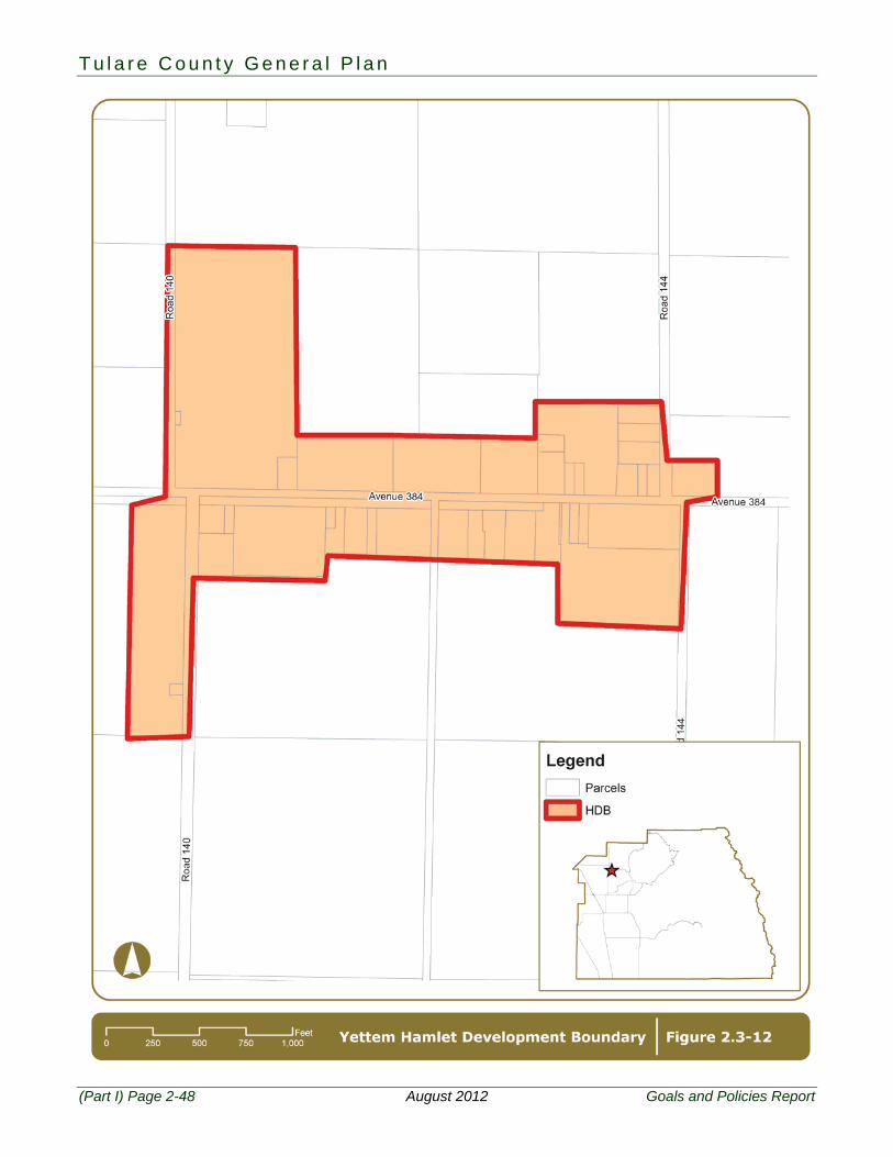
2.3 Hamlets Figure 2.3-1 shows the locations of all eleven unincorporated Hamlets within Tulare County and Figures 2.3-2 through 2.3-12 show the County’s HDBs adopted for each Hamlet:
Allensworth Delft Colony East Tulare Villa Lindcove Monson Seville
Teviston Tonyville Waukena West Goshen Yettem
PF-3 To provide a realistic planning area around each unincorporated hamlet to clearly delineate the boundaries of each hamlet, provide a framework for economic development, the provision of public services, and an outstanding quality of life.
PF-3.1 Hamlet Development Boundaries - Hamlets
The County shall limit urban development to the area within the designated HDB for each hamlet. The HDBs for existing hamlets are defined on Figures 2.3-2 thru 2.3-12.
PF-3.2 Modification of HDB - Hamlet
1. The County may consider modification of a HDB under any of the following circumstances:
a. All HDBs should be reviewed on a five-year cycle to reflect changes in growth and development patterns.
b. A request for expansion can be applied for as part of a subdivision or specific plan proposal, or at the request of a special district or Hamlet. A request for expansion of the HDB can be applied for as part of a General Plan Amendment to the Land Use Diagram.
c. An HDB should be considered for expansion at such time as land for infill becomes limited. This condition is considered satisfied when 80 percent of the non-Williamson Act land within the HDB is developed.
d. HDBs should not be expanded onto Prime Farmland if Farmland of Statewide Importance or of lesser quality is available and suitable for expansion.
2. Prior to approval of a HDB expansion, the County shall ensure that appropriate infrastructure can be provided to serve the new areas added to the HDB and that sufficient water supplies are available. If the expansion pushes the hamlet towards a community classification, an infrastructure master plan for the hamlet should be prepared to plan and finance community water and sewer services, and representation/documentation of availability and sufficiency of long-term water supplies should be provided.
3. Preservation of productive agricultural lands shall be the highest priority when considering modifications. Expansion of a HDB to include additional agricultural land shall only be allowed when other non-agricultural lands are not available to the community for expansion.
4. All changes to a HDB shall require a General Plan amendment. PF-3.3 Hamlet Plans
T u l a r e C o u n t y G e n e r a l P l a n
(Part I) Page 2-36 August 2012 Goals and Policies Report
The County shall ensure that Hamlet Plans are updated and maintained for each of the identified hamlets. These plans shall include the entire area within the HDB. The plans will provide a Land Use Diagram with a discussion of allowed uses and densities/intensities. A discussion of the hamlet’s short and long term ability to provide necessary urban services, including the availability and sufficiency of long-term water supplies will also be provided.
PF-3.4 Mixed Use Opportunities
Unless or until a traditional plan approach is requested by the hamlet and such a plan is adopted, land use designations within the HDB shall be the mixed use land use designations as provided in Chapter 4-Land Use that promotes the integration of a compatible mix of residential types and densities, commercial uses, public facilities and services, and employment opportunities.
PF-3.5 Improvement Standards in Hamlets
The County shall require development within the designated HDBs to meet context sensitive standards for improvements. Typical improvements could include curbs, gutters, sidewalks, and community sewer and water systems.
PF-3.6 Becoming a Community
For hamlets meeting the definition of a community, or at the discretion of the Board of Supervisors, a hamlet or other unincorporated place can be designated as a community. Once designated, the new community will be subject to the goals and policies designated for communities, and a Community Plan (consistent with the requirements of PF-2.4: Community Plans) be completed.
Text continues on Page 2-49.
2 . P l a n n i n g F r a m e w o r k
Goals and Policies Report August 2012 (Part I) Page 2-37
T u l a r e C o u n t y G e n e r a l P l a n
(Part I) Page 2-38 August 2012 Goals and Policies Report
2 . P l a n n i n g F r a m e w o r k
Goals and Policies Report August 2012 (Part I) Page 2-39
T u l a r e C o u n t y G e n e r a l P l a n
(Part I) Page 2-40 August 2012 Goals and Policies Report
2 . P l a n n i n g F r a m e w o r k
Goals and Policies Report August 2012 (Part I) Page 2-41
T u l a r e C o u n t y G e n e r a l P l a n
(Part I) Page 2-42 August 2012 Goals and Policies Report
2 . P l a n n i n g F r a m e w o r k
Goals and Policies Report August 2012 (Part I) Page 2-43
T u l a r e C o u n t y G e n e r a l P l a n
(Part I) Page 2-44 August 2012 Goals and Policies Report
2 . P l a n n i n g F r a m e w o r k
Goals and Policies Report August 2012 (Part I) Page 2-45
T u l a r e C o u n t y G e n e r a l P l a n
(Part I) Page 2-46 August 2012 Goals and Policies Report
2 . P l a n n i n g F r a m e w o r k
Goals and Policies Report August 2012 (Part I) Page 2-47
T u l a r e C o u n t y G e n e r a l P l a n
(Part I) Page 2-48 August 2012 Goals and Policies Report
2 . P l a n n i n g F r a m e w o r k
Goals and Policies Report August 2012 (Part I) Page 2-49
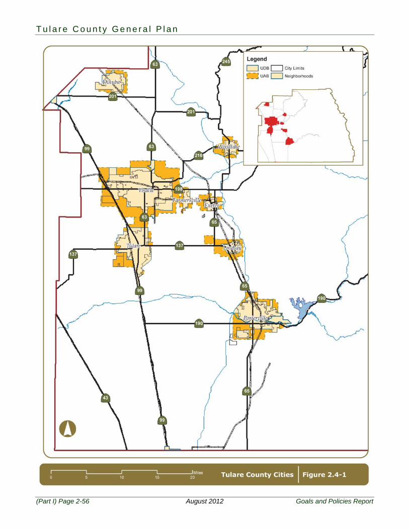
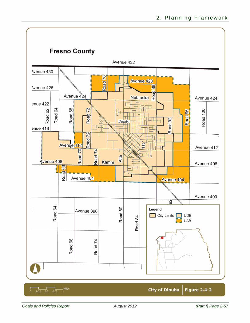
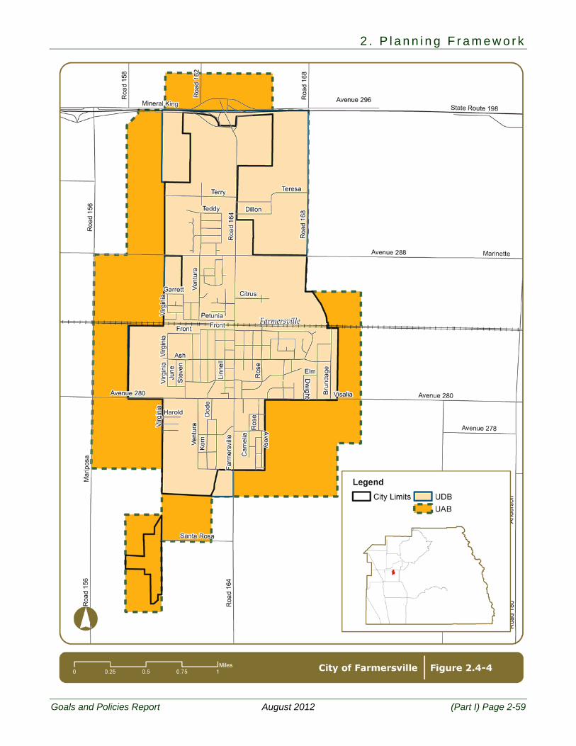
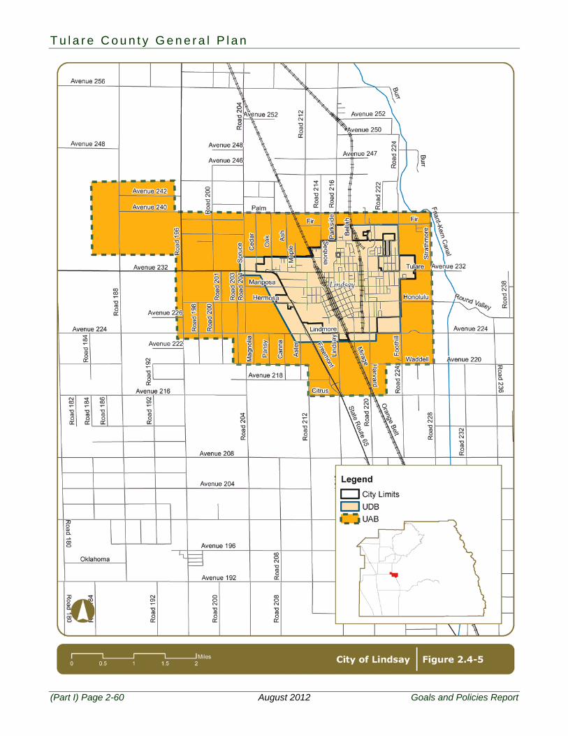
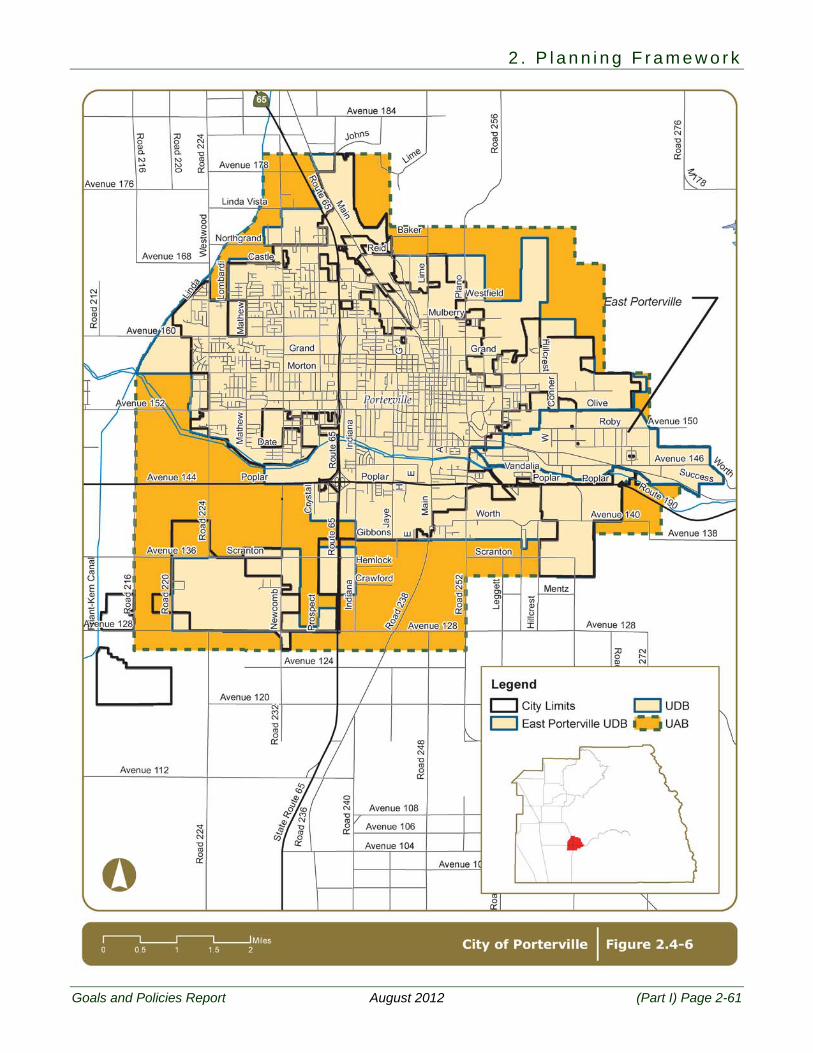
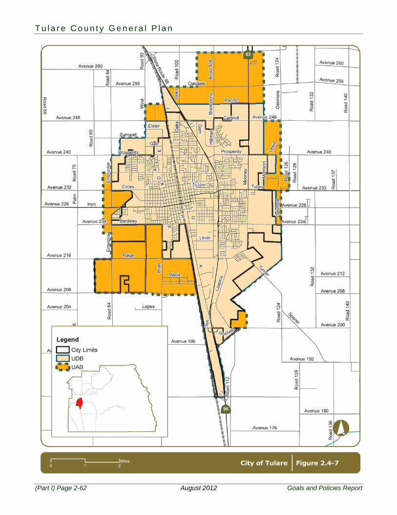
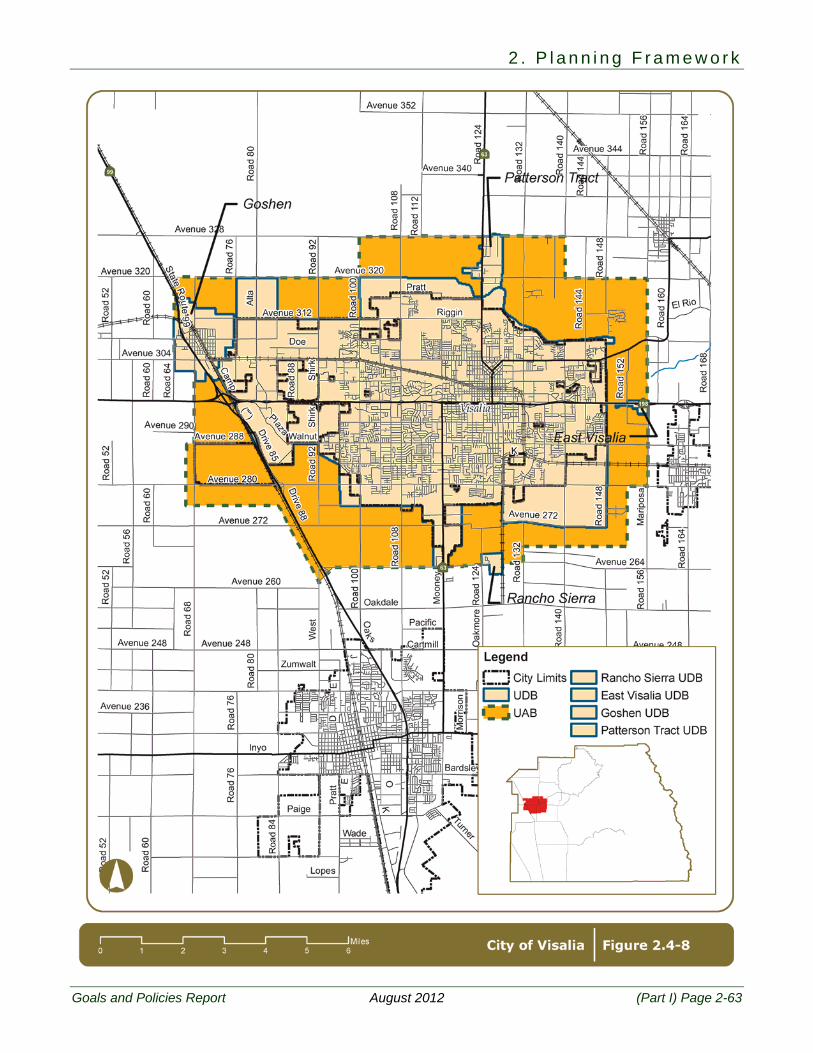
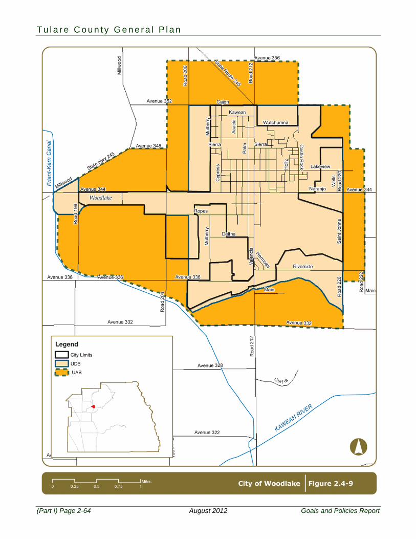
2.4 Cities Figure 2.4-1 shows the locations of all eight incorporated cities within Tulare County and Figures 2.4-2 through 2.4-9 show the County Adopted City Urban Development Boundaries (CACUDBs) and County Adopted City Urban Area Boundaries (CACUABs) for each city:
Dinuba Exeter Farmersville Lindsay
Porterville Tulare Visalia Woodlake
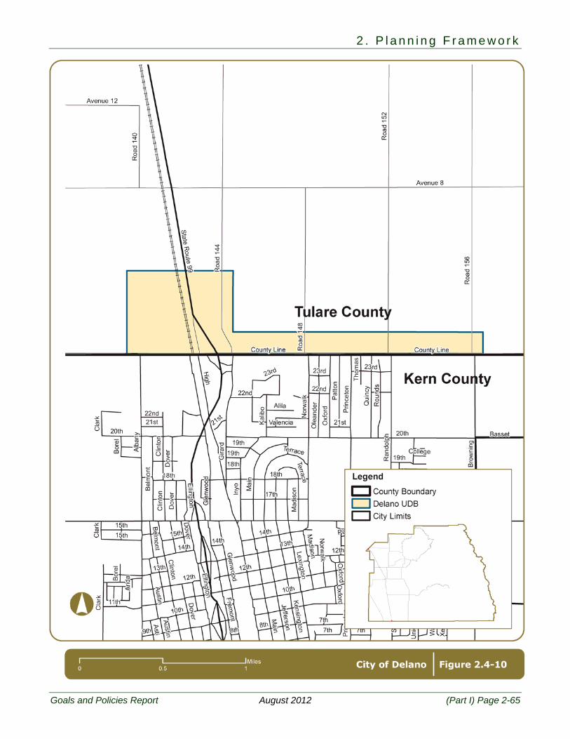
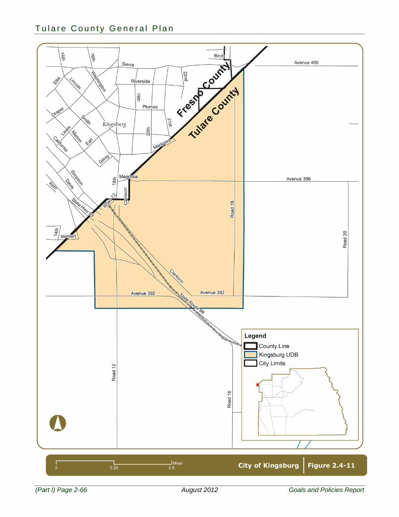
In addition, two cities outside of the County share a common border with the County and there has been urban development in adjacent County unincorporated areas. These two cities are Delano and Kingsburg. The County has established UDBs for these cities/areas as shown in Figures 2.4-10 and 2.4-11. The following goal and policies are designed to foster a cooperative planning environment between the County and each city with respect to development within the fringe areas of the cities.
PF-4 To direct urban development within UDBs of existing incorporated cities and ensure that all development in unincorporated areas adjacent to incorporated cities is well planned and adequately served by necessary infrastructure and other public facilities and furthers countywide economic development goals.
PF-4.1 CACUABs for Cities
The County shall establish CACUABs which define the area where land uses are presumed to have an impact upon the adjacent incorporated city, and within which the cities’ concerns may be given consideration as part of the land use review process. The lands within the UAB are considered to be the next logical area in which urban development may occur and the area within which UDBs may ultimately be expanded. Although it is the policy of the County that this area will at some time become appropriate for urban development, generally no public purpose is served by permitting intensive development therein. As communities grow and expand, it is logical to assume the UDBs may be correspondingly expanded or established until they coincide with the ultimate UAB. The land lying between the Urban Development Boundary and the Urban Area Boundary will generally have an agricultural land use designation or rural residential land use designation in conformity with Land Use Policy LU 3.8: Rural Residential Interface.
PF-4.2 CACUDBs for Cities – Twenty Year Planning Area
The County shall establish CACUDBs which define the anticipated twenty-year planning areas around incorporated cities in which the County and cities may coordinate plans, policies, and standards relating to building construction, subdivision development, land use and zoning regulations, street and highway construction, public utility systems, environmental studies, water supply availability and sufficiency, and other closely related matters affecting the orderly development of areas adjacent to incorporated cities. It is recognized that these boundaries provide an official definition of the interface between future urban and agricultural land uses.
Within this boundary, the County may also establish planning areas representative of shorter time periods in order to assist in more precise implementation of plans and policies.
T u l a r e C o u n t y G e n e r a l P l a n
(Part I) Page 2-50 August 2012 Goals and Policies Report
PF-4.3 Modification of CACUABs and CACUDBs The County may consider modification of CACUABs and CACUDBs at such time as the land use plan for a city is revised to reflect changing needs and circumstances over an extended time frame. Preservation of productive agricultural lands and operations shall be one consideration when considering such modifications. Cities may examine existing CACUAB and CACUDB lines and recommend changes to the Board of Supervisors, as appropriate.
PF-4.4 Planning in CACUDBs
The County acknowledges that the cities have an interest in planning for growth within a CACUDBs and will in the future become ultimately responsible for urban development and the provision of urban services within those areas upon annexation.
PF-4.5 Spheres of Influence
CACUDBs and the SOI as administered by LAFCo may be consistent insofar as it is feasible and appropriate to do so.
PF-4.6 Orderly Expansion of City Boundaries
When the County is considering outward expansion of CACUDBs, the following criteria shall be encouraged:
1. The city has demonstrated a need for additional territory after documenting a good faith
effort to implement programs for infill development and/or increased efficiency of development and minimize conversion of agricultural lands.
2. UDBs should not be expanded onto Prime Farmland if Farmland of Statewide Importance or of lesser quality is available and suitable for expansion.
3. Emphasis shall be placed upon reasonable expectations for the provision of urban services within the next twenty years as reflected in LAFCo’s Municipal Service Reviews when determining the location of UDBs.
PF-4.7 Avoiding Isolating Unincorporated Areas
The County may oppose any annexation proposal that creates an island, peninsula, corridor, or irregular boundary. The County will also encourage the inclusion of unincorporated islands or peninsulas adjacent to proposed annexations.
PF-4.8 Updating Land Use Diagram in CACUDBs
Following city adoption of a General Plan update or amendment that reflects the area within a CACUDB, the County shall update Part III (Community Plans, Kings River Plan, Mountain Sub-Area Plans, and CAC General Plans), if applicable, to reflect the city’s modified plan. Any unresolved conflicts between the County and city plans shall be identified for the Board of Supervisors. The County shall establish and maintain land use controls on unincorporated lands within the UDB consistent with the policies of the County General Plan.
PF-4.9 Transition to Agricultural Use
The County shall encourage cities to adopt land use policies that minimize potential conflicts with agricultural operations and other agricultural activities at the urban edge through the provision of appropriate buffers or other measures.
PF-4.10 Urban Improvement Areas for Cities
All Urban Improvement Areas established in the 1974 Urban Boundaries Element for cities and adjacent cities in adjacent counties, are hereby converted to Urban Development Boundaries.
2 . P l a n n i n g F r a m e w o r k
Goals and Policies Report August 2012 (Part I) Page 2-51
PF-4.11 Coordination with Cities in Adjacent Counties The policies set forth in this Section (PF-4: Cities) shall also apply to planning and development within the UDBs of adjacent cities in adjacent counties (Corcoran, Delano, Kingsburg, Orange Cove, and Reedley), except Policy PF-4.4: Planning in UDBs.
PF-4A
To provide the means to further manage urban development within CACUDBs and CACUABs of existing incorporated cities while ensuring that the limitation on development is in the best interests of the County and its residents in both the incorporated and unincorporated areas and enhances the County’s ability to provide adequate County facilities and countywide social, health, safety and welfare services impacted by development in the cities and County.
The following policies will become applicable upon mutually adopted agreement between the County and each city regarding the collection of public facilities impact fees in accordance with policies PF-4.12 and PF-4.27. PF-4.12 General Plan Designations Within City UDBs
On land that is within a CACUDB, but outside a city’s incorporated limits, the County may maintain General Plan land use designations that are compatible with the city’s adopted General Plan.
PF-4.13 City Design Standards
Where the Board of Supervisors finds that it is consistent with General Plan objectives to approve development within the UDBs of incorporated cities, the County may require the project to substantiate sufficient water supply and meet the County adopted city development standards of the city in question.
PF-4.14 Compatible Project Design
The County may ensure proposed development within CACUABs is compatible with future sewer and water systems, and circulation networks as shown in city plans.
PF-4.15 Coordination with Cities on Development Proposals
The County shall ensure that urban development only take place in CACUDBs if one of the following has occurred:
1. The adjacent city does not consent to annex the property for development purposes (as evidenced through pre-zoning, development agreements, etc.); it shall be conclusively presumed that a city has not consented if it has not submitted an annexation proposal to LAFCo within six months from the date a request to annex is submitted to the city; or
2. Annexation is not possible under the provisions of State law, but it is determined by the County that development of the site does not constitute incompatible development.
PF-4.16 Revenue Sharing
As an incentive for directing urban growth into cities when applications are proposed within the CACUDBs, the County shall promote revenue sharing as an element of negotiation whenever:
1. A city updates its General Plan and requests the County to update its CAC General Plan.
2. When establishment or amendment to Spheres of Influence are proposed.
T u l a r e C o u n t y G e n e r a l P l a n
(Part I) Page 2-52 August 2012 Goals and Policies Report
3. Annexations are proposed by cities, or joint development or redevelopment projects are proposed by any city and the County.
As an additional incentive for directing urban growth into cities, any city proposing changes to a CAC General Plan or other County land use regulations shall pay to the County its cost in considering and implementing such proposal.
PF-4.17 Cooperation with Individual Cities
The County may use the policies set forth under this goal (PF-4A: Cities: Continued) to work with individual cities to further manage development within that CACUDB or CACUAB to the extent that the financial needs of the County are met and the County’s ability to provide facilities and County services used by all of the residents in the County and cities is enhanced. The County and Cities will establish a working committee to facilitate the policies identified in this section 4A.
PF-4.18 Future Land Use Entitlements in a CACUDB
The County may work with an individual city to limit any General Plan amendments to change the land use designations of any parcel or any amendments to the County zoning ordinance to add uses to a current zoning classification or change the zoning district designation of any parcel within a CACUDB except as follows:
1. This policy will not apply to amendments or changes to a County unincorporated UDB, Hamlet Development Boundary (HDB), including where the boundary line may increase an outward expansion of the overlap area with a CACUDB area that is not coterminous to the city’s Urban Development Boundary/Sphere of Influence (UDB or SOI), or to any General Plan amendment adopting a new County unincorporated UDB, an HDB, or Planned Community, County Corridor development nodes will not be located inside a city’s UDB or SOI unless mutually agreed by the City and County.
2. This policy will not apply where the General Plan land use designation or the zoning district classification of a particular parcel is inconsistent with an existing special use permit, or legal non-conforming use.
3. As determined by the RVLP checklist, the County shall encourage beneficial reuse of existing or vacant agricultural support facilities for new businesses (including non-agricultural uses), and for which the city cannot or will not annex as per PF-4.24.
4. This policy will not apply where the effect of the amendments to the General Plan land use designation or of the rezoning is to designate or zone the parcel to an agricultural designation or zone except where the effect of the amendment creates a less intensive agricultural designation or zone.
5. This policy will not apply where amendments to the General Plan land use designations or the zoning classifications apply only to that portion of a CACUDB that is overlapped (where exterior UDB’s are coterminous) by a County unincorporated UDB, Hamlet Development Boundary (HDB), or Corridor Plan area.
6. This policy will not apply where amendment to the General Plan land use designation or the zoning classification is required to bring the County regulations into compliance with more restrictive State or Federal statutes or regulations.
7. This policy will not apply where amendments to the Zoning Ordinance are part of a comprehensive modernization or restructuring of the processes or procedures set out in the Zoning Ordinance or part of a comprehensive update to the text of the zoning classifications to bring the Zoning Ordinance procedures and text into consistency with the General Plan update. [This comprehensive modernization, restructuring or update
2 . P l a n n i n g F r a m e w o r k
Goals and Policies Report August 2012 (Part I) Page 2-53
would not include any rezonings outside that allowed in this policy. However, revision of processes and procedures and simplification of existing ordinances may occur.]
8. This policy would not apply to a comprehensive update of a CAC General Plan, including rezoning there under, in cooperation with the affected city.
9. This policy would not apply where the County has worked with the city to identify and structure a mutually acceptable alternative General Plan land use designation or zoning classification.
PF-4.19 Future Land Use Entitlements in a CACUAB
As an exception to the County policies that the Rural Valley Lands Plan (RVLP) does not apply within CACUDBs and is only advisory within CACUABs, the County may work with an individual city to provide that no General Plan amendments or rezonings will be considered to change the current land use designation or zoning classification of any parcel within a CACUAB unless appropriate under the requirements of the Rural Valley Lands Plan (RVLP) or similar checklist or unless the County has worked with the city to identify and structure an acceptable alternative General Plan land use designation or zoning classification. This policy will not apply to amendments or changes to a County unincorporated UDB, Hamlet Development Boundary (HDB), or Corridor Plan area boundary line, including where the boundary line may increase an overlap area with a CACUDB area, or to any General Plan amendment adopting a new UDB, an HDB, or Corridor Plan area that may fall within a CACUDB area. This policy shall not apply within a County unincorporated UDB, an HDB, or Corridor Plan area where that area overlaps a CACUAB area. Development of County corridor development nodes in an affected city’s UAB would only occur after the County has provided written consultation and has allowed for a reasonable timed response from the affected city prior to decision making and before the adoption of the Corridor Plan. New development in a city’s UAB would be subject to adopted plan lines and setback standards. Adopted facility plans and legally adopted General Plans will be considered during the development review process. Small “stand alone,” non urban projects which are defined as residential projects of four or fewer lots or non-residential projects smaller than two acres do not need city standards but shall respect city utility and street master plans for setbacks. Large urban-style projects include residential projects of five or more lots averaging less than one acre per lot and non-residential projects two acres or larger will use uniform urban development standards, financing mechanisms, consent to annexation, application of reciprocal development impact fees and city streets/utility setbacks/disclosure requirements unless the County and the city have identified and structured acceptable alternatives that will reasonably ensure that these projects should conform to city development standards upon future annexation.
PF-4.20 Application of the RVLP Checklist to Control Development in a CACUDB As an exception to the County policies that the Rural Valley Lands Plan does not apply within CACUDBs, the County may work with an individual city to provide that the requirements of the RVLP or similar checklist will apply to applications for special use permits (including special use permits for the expansion of a non-conforming use), variances considered under Government Code § 65906, or to the extent allowed by law, divisions of land within a CACUDB except in those areas that overlap with a County unincorporated UDB, an HDB, or Corridor Plan area. Such a special use permit, variance, or division of land will be reviewed in light of impacts on such regional concerns as water and sewage disposal availability and preservation of transportation and utility corridors as well as compliance with any County adopted urban or city development standards and with the city’s General Plan policies as reflected in the CAC General Plan.
T u l a r e C o u n t y G e n e r a l P l a n
(Part I) Page 2-54 August 2012 Goals and Policies Report
PF-4.21 Application of the RVLP Checklist to Control Development in a CACUAB As an exception to the County policies that the Rural Valley Lands Plan is only advisory within CACUABs, the County may work with an individual city to provide that the requirements of the RVLP will apply to applications for special use permits (including special use permits for the expansion of a non-conforming use), variances considered under Government Code § 65906, or to the extent allowed by law, divisions of land within a CACUAB except in those areas that overlap with a County unincorporated UDB, an HDB, or Corridor Plan area. Such a special use permit, variance, or division of land will be reviewed in light of impacts on such regional concerns as water and sewage disposal availability and preservation of transportation and utility corridors.
Also see Part II-Policy RVLP-1.4: Determination of Agriculture Land and Section 1.3: Rural Valley Lands Plan Criteria and Evaluation Matrix.
PF-4.22 Reuse of Abandoned Improvements in a CACUDB
In accordance with other policies in this General Plan, the County may work with a city to provide that any alternative land uses within a CACUDB not otherwise allowed under a particular zoning classification but which are allowed by County policies due to the existence of abandoned structures or improvements with no other available, viable economic uses on the parcel will be reviewed in light of impacts on such regional concerns as water and sewage disposal availability and preservation of transportation and utility corridors. For agricultural related uses, reoccupation and/or expansion is limited not to exceed 20% of the site and/or building square footage subject to special use permit with city consultation. Conversion to non-agricultural uses requiring a zone change is limited not to exceed 20% of the site and/or building square footage or as mutually agreed upon by the city and County. Any expansions are subject to a special use permit.
PF-4.23 Reuse of Abandoned Improvements in a CACUAB In accordance with other policies in this General Plan, the County may work with a city to provide that any alternative uses within a CACUAB not otherwise allowed under a particular zoning classification but which are allowed by County policies due to the existence of abandoned structures or improvements with no other available, viable economic uses on the parcel will be reviewed in light of impacts on such regional concerns as water and sewage disposal availability and preservation of transportation and utility corridors expansion or re-occupation will require irrevocable consents to annex, and accommodation for setbacks and other standards for future streets and utilities. The RVLP will be used to determine if non-agricultural use is appropriate.
PF-4.24 Annexations to a City within the CACUDB In addition to the County’s current policies on development within a CACUDB, the County may work with a city to provide that urban development projects within a city’s Sphere of Influence (SOI) as set by the Tulare County Local Agency Formation Commission will be referred to the affected city for consideration of annexation in accordance with, but not limited to, the following concepts:
1. Urban development projects, to which the referral policy applies, would be those projects for which a discretionary permit is required. Any urban development project not subject to special use permit requirements would still comply with County adopted city development standards, CAC General Plans and zoning and any County adopted city long-range infrastructure plan.
2. The referral would, at least, be subject to the requirement that the city inform the County within three (3) months that it is or is not able and willing to commence annexation
2 . P l a n n i n g F r a m e w o r k
Goals and Policies Report August 2012 (Part I) Page 2-55
proceedings to accommodate the project; or the city is willing and able to commence annexation proceedings, the County would not take action to approve the project unless the applicant has submitted a completed application for annexation and city fails to take action on such application within six months;
3. If the affected city is not willing or able to commence annexation proceedings, approval by the County of the project would be conditioned on conformance with County adopted city development standards, County Adopted City General Plans and zoning and any County adopted city long-range infrastructure plan adopted.
4. The County may, as part of this policy, require a consent to future annexation be recorded concurrent with approval of the project special use permit for development within the County.
PF-4.25 Sphere of Influence Criteria
In addition to the County current policies on annexations and city growth lines, the County may work with one or more cities to propose criteria to the Tulare County Local Agency Formation Commission (LAFCo) for use in the adoption of city Sphere of Influence (SOI) lines consistent with the concept that the SOI is a twenty year city growth boundary including the city’s “communities of interest” as defined by LAFCo, and that an affected city should seek approval of amendment by LAFCo of its current SOI lines to reflect such criteria. Communities of interest not included within the SOI may be considered and included in a fifty year growth boundary. If such a criteria is adopted, the County, as a city SOI is brought into compliance with such criteria, may consider amendment of it general plan to make the CACUDB identified in the County general plan, to the extent appropriate, consistent or conterminous with the LAFCo adopted SOI.
PF-4.26 City 50 Year Growth Boundaries In addition to the County current policies on city boundary lines, the County may work with one or more of the cities to propose that LAFCo consider the adoption of a fifty year growth boundary for each city and to propose criteria to LAFCo for adoption of that boundary. If LAFCo adopts fifty year growth boundaries consistent with such criteria, the County may consider amendments to its general plan to make the CACUAB, to the extent appropriate, consistent or conterminous with the city’s LAFCo adopted fifty year growth boundary.
PF-4.27 Impacts of Development within the County on City Facilities and County Facilities The County may work with a city to consider the adoption, imposition and collection for payment to the city pursuant to agreement Development Impact Fees within the CACUDB, as may be proposed by the city from time to time to offset the impacts of development in the County on city facilities. Reciprocally and under the same conditions, the city will consider the collection of Development Impact Fees within the city to offset the impact of development within the city on County facilities.
T u l a r e C o u n t y G e n e r a l P l a n
(Part I) Page 2-56 August 2012 Goals and Policies Report
2 . P l a n n i n g F r a m e w o r k
Goals and Policies Report August 2012 (Part I) Page 2-57

T u l a r e C o u n t y G e n e r a l P l a n
(Part I) Page 2-58 August 2012 Goals and Policies Report
2 . P l a n n i n g F r a m e w o r k
Goals and Policies Report August 2012 (Part I) Page 2-59
T u l a r e C o u n t y G e n e r a l P l a n
(Part I) Page 2-60 August 2012 Goals and Policies Report
2 . P l a n n i n g F r a m e w o r k
Goals and Policies Report August 2012 (Part I) Page 2-61
T u l a r e C o u n t y G e n e r a l P l a n
(Part I) Page 2-62 August 2012 Goals and Policies Report
2 . P l a n n i n g F r a m e w o r k
Goals and Policies Report August 2012 (Part I) Page 2-63
T u l a r e C o u n t y G e n e r a l P l a n
(Part I) Page 2-64 August 2012 Goals and Policies Report
2 . P l a n n i n g F r a m e w o r k
Goals and Policies Report August 2012 (Part I) Page 2-65
T u l a r e C o u n t y G e n e r a l P l a n
(Part I) Page 2-66 August 2012 Goals and Policies Report
2 . P l a n n i n g F r a m e w o r k
Goals and Policies Report August 2012 (Part I) Page 2-67
2.5 New Towns
PF-5 To provide for orderly development of new areas within the County when appropriate to meet the social and economic needs of current and future residents, consistent with the goals and policies of the Tulare County General Plan.
PF-5.1 New Towns (Planned Communities)
The haphazard development of communities should be discouraged. However, should circumstances appear to justify development of a new or “planned” community with its own mix of residential, commercial, industrial, public use areas and related facilities, it should be judged on its individual merits and functions as it would affect the area as a whole and other policies and proposals of the General Plan.
PF-5.2 Criteria for New Towns (Planned Communities)
When evaluating proposals for New Town development, the County shall require all of the following:
1. That a New Town be a planned community as defined by the Tulare County Zoning
Ordinance. The planned community may take the form of a Specific Plan, Community Plan, or Master Development Plan.
2. That a reimbursement agreement, memorandum of understanding, and investment agreement for the project be established prior to submittal of a planned community proposal.
3. That the applicant demonstrate the project will have a fiscally neutral or positive impact on the County and special districts impacted by the project.
4. That an infrastructure master plan for the installation, operation, management and funding, and ongoing maintenance and replacement of infrastructure required to support growth, including but not limited to: State, local, and private transportation; sewage; water quality and quantity; drainage; parks and open space; and any other infrastructure or public services, appropriate regulations, programs or public works projects, be prepared to ensure that each of the development projects “pay their fair share”. That a water assessment be completed to evaluate the availability and sufficiency of water to meet anticipated demands. That funding mechanisms are set up to cover initial capital costs as well as long-term operations and maintenance for the facilities including but not limited to the ones listed above.
5. That an outreach and community involvement process be conducted as will be defined in the work program/memorandum of understanding for the project.
6. That the planning program include joint meetings with all stakeholder agencies involved in infrastructure or services provision for the project by forming an intergovernmental advisory committee, as well as one-on-one consultations, to help guide the process, including preparation of the environmental impact report (EIR), water supply assessment, and infrastructure master plan. Regular participants on this committee should include but not be limited to any: applicable local planning committee established by the Board of Supervisors or Planning Commission; redevelopment project advisory committee; special use district; TCAG; Caltrans District 6; and school districts. Other participants may, from time to time include: Fire Chief; Cal Fire; County Sheriff; water conservation district; Department of Conservation; Fish & Wildlife; Department of Fish & Game; California State Parks; phone company; and utility companies.

T u l a r e C o u n t y G e n e r a l P l a n
(Part I) Page 2-68 August 2012 Goals and Policies Report
7. The applicant shall enter into a reimbursement agreement requiring deposits into a planning trust fund with Tulare County Resource Management Agency. The reimbursement agreement shall insure that the cost of all or an agreed upon portion of General Plan amendment, EIR preparation, infrastructure master plan, peer review, and all other technical studies and reports shall be paid by the developer or otherwise recovered by the County.
8. The preparation and approval of a Community Plan or Master Plan and a Specific Plan for the project.
9. That adequate and sustainable water supplies be documented.
10. That the project strives to provide a balance mix of land uses and densities, including residential, commercial, employment generating, and public facilities.
11. That the project provides a full range of needed infrastructure and public services, including:
a. Appropriate on-site and off-site circulation and improvements,
b. Adequate community water and sewer facilities, and
c. Fire protection, law enforcement, parks, library, community center, and other necessary public facilities.
12. Planned communities should not cause any conversion of Prime Farmland if Farmland of Statewide Importance or of lesser quality is available and suitable for development.
13. That the planned communities be consistent with the policies of the associated Area Plan (Part II).
2.6 Coordination and Cooperation
PF-6 To work with agencies, districts, utilities, and Native American tribes to promote consistency with the County’s General Plan.
PF-6.1 Plans for Jurisdictions, Agencies, District, Utilities, and Native American Tribes
The County shall work with Tulare County cities; adjacent counties and cities; Federal, State, and regional agencies; local districts; utility providers; Native American tribes; and the military to ensure that their plans are consistent with Tulare County’s General Plan to the greatest extent possible.
PF-6.2 Intergovernmental Coordination
The County shall work with Federal, State, and regional agencies; local districts; utility providers; Native American tribes; and the military to ensure that the County and the public are involved, as appropriate, throughout any planning process and that agency and public input is requested.
The California Military Land Use Compatibility Analyst is available from the California Governors Office of Planning and Research website.
PF-6.3 Consultation on Annexation Proposals
The County shall promote consultation early in the planning process between the cities and the County at the staff level when cities are developing proposed annexation boundaries or proposed sphere of influence expansions. The desire is to provide ongoing coordination at a
2 . P l a n n i n g F r a m e w o r k
Goals and Policies Report August 2012 (Part I) Page 2-69
point earlier than the minimum 30 day notice required by State law and consistent with LAFCo law.
PF-6.4 UDBs and Interagency Coordination
The County shall use UDBs to provide a definition of an urban area for other planning programs, such as:
1. The area within the UDB should be considered as the same area for which water and
sewer system planning may be needed and to be a consideration in the determination of an area required to adequately assess the availability and sufficiency of water supplies.
2. UDBs should be used to define traffic analysis zones in the Regional Transportation Plan program.
3. The UDBs shall be used to provide a framework for inventories on growth and development, as well as socio-economic data.
PF-6.5 Regional Planning Coordination
The County shall coordinate with adjacent counties and their cities, regional councils of governments, and State agencies to ensure coordination on infrastructure efforts and funding in the region.
PF-6.6 Coordination of Private Development on Public Land
The County will work cooperatively with State and Federal agencies to coordinate private development on public lands.
PF-6.7 Public Outreach
The County shall continue its practice of effective citizen participation and outreach, using a variety of techniques with activities held at different times and days, and with language interpretation as necessary to involve as many people as possible in the outreach.
2.7 General Plan Maintenance
PF-7 To provide for the ongoing administration and implementation of the Tulare County General Plan.
PF-7.1 Annual Review
The County shall annually review the General Plan Goals and Policies Report, focusing primarily on reporting the actions taken in the previous year to carry out the implementation measures of the General Plan. The Planning Commission shall complete this review and report its findings to the Board of Supervisors as per Government Code §65400. The Planning Commission’s report shall include, as the Planning Commission deems appropriate, recommendations for amendments to the General Plan. This annual report may also be used to satisfy the requirements of the Public Resources Code (§21081.6) for a mitigation monitoring program.
PF-7.2 Maintaining a Current General Plan
The County shall periodically (every 5 to 10 years) conduct a major review of the General Plan, including the General Plan Goals and Policies Report and Background Report to ensure the General Plan is addressing the needs of the County. Issues identified will be addressed as part of an amendment or update. The County shall maintain and shall collect a General Plan, Unincorporated Community Plan, and Code Maintenance fees at building
T u l a r e C o u n t y G e n e r a l P l a n
(Part I) Page 2-70 August 2012 Goals and Policies Report
permit issuance as established by the Board of Supervisors, to insure that the resources are available to fund the required updates of the General Plan.
PF-7.3 Maintaining Planning Consistency
The County shall review and revise all applicable County documents to ensure consistency with the General Plan. The County shall maintain and shall collect a General Plan, Unincorporated Community Plan, and Code Maintenance fee at building permit issuance as established by the Board of Supervisors, to insure that the resources are available to fund the required updates of the General Plan.
PF-7.4 Providing Planning Information
The County shall ensure that the public has access to all public records in accordance with provisions of all State laws and conducts multi-lingual programs as required by State law.
Please see next page.
2 . P l a n n i n g F r a m e w o r k
Goals and Policies Report August 2012 (Part I) Page 2-71
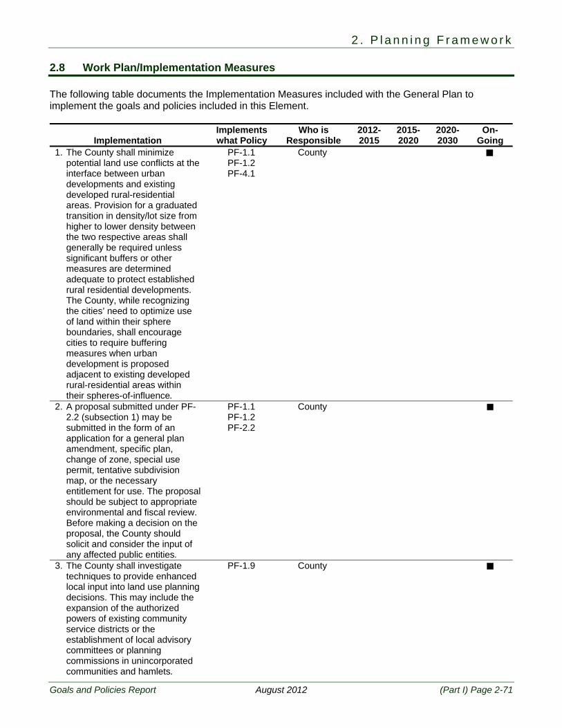
2.8 Work Plan/Implementation Measures The following table documents the Implementation Measures included with the General Plan to implement the goals and policies included in this Element.
Implementation Implements what Policy
Who is Responsible
2012-2015
2015-2020
2020-2030
On-Going
1. The County shall minimize potential land use conflicts at the interface between urban developments and existing developed rural-residential areas. Provision for a graduated transition in density/lot size from higher to lower density between the two respective areas shall generally be required unless significant buffers or other measures are determined adequate to protect established rural residential developments. The County, while recognizing the cities’ need to optimize use of land within their sphere boundaries, shall encourage cities to require buffering measures when urban development is proposed adjacent to existing developed rural-residential areas within their spheres-of-influence.
PF-1.1 PF-1.2 PF-4.1
County
2. A proposal submitted under PF-2.2 (subsection 1) may be submitted in the form of an application for a general plan amendment, specific plan, change of zone, special use permit, tentative subdivision map, or the necessary entitlement for use. The proposal should be subject to appropriate environmental and fiscal review. Before making a decision on the proposal, the County should solicit and consider the input of any affected public entities.
PF-1.1 PF-1.2 PF-2.2
County
3. The County shall investigate techniques to provide enhanced local input into land use planning decisions. This may include the expansion of the authorized powers of existing community service districts or the establishment of local advisory committees or planning commissions in unincorporated communities and hamlets.
PF-1.9 County
T u l a r e C o u n t y G e n e r a l P l a n
(Part I) Page 2-72 August 2012 Goals and Policies Report
Implementation Implements what Policy
Who is Responsible
2012-2015
2015-2020
2020-2030
On-Going
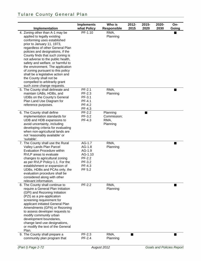
4. Zoning other than A-1 may be applied to legally existing conforming uses established prior to January 11, 1973, regardless of other General Plan policies and designations, if the County finds that such zoning is not adverse to the public health, safety and welfare, or harmful to the environment. The application of zoning pursuant to this policy shall be a legislative action and the County shall not be compelled to arbitrarily grant such zone change requests.
PF-1.10 RMA, Planning
5. The County shall delineate and maintain UABs, HDBs, and UDBs on the County’s General Plan Land Use Diagram for reference purposes.
PF-2.1 PF-2.3 PF-3.1 PF-4.1 PF-4.2 PF-4.3
RMA, Planning
6. The County shall define implementation standards for UDB and HDB expansions to avoid uncertainty, including developing criteria for evaluating when non-agricultural lands are not ‘reasonably available’ or ‘suitable’.
PF-2.2 PF-3.2 PF-4.3
Planning Commission; RMA, Planning
7. The County shall use the Rural Valley Lands Plan Parcel Evaluation Procedure within RVLP areas to evaluate changes to agricultural zoning as per RVLP Policy-1.1. For the establishment or expansion of UDBs, HDBs and PCAs only, the evaluation procedure shall be considered along with other relevant information.
AG-1.7 AG-1.8 AG-1.9 AG-1.10 PF-2.2 PF-3.2 PF-4.3 PF 5.2
RMA, Planning
8. The County shall continue to require a General Plan Initiation (GPI) and Rezoning Initiation (PZI) as a pre-application screening requirement for applicant initiated General Plan Amendments (GPA) or Rezoning to assess developer requests to modify community urban development boundaries, change land use designations, or modify the text of the General Plan.
PF-2.2 RMA, Planning
9. The County shall prepare a community plan program that
PF-2.3 PF-2.4
RMA, Planning
2 . P l a n n i n g F r a m e w o r k
Goals and Policies Report August 2012 (Part I) Page 2-73
Implementation Implements what Policy
Who is Responsible
2012-2015
2015-2020
2020-2030
On-Going
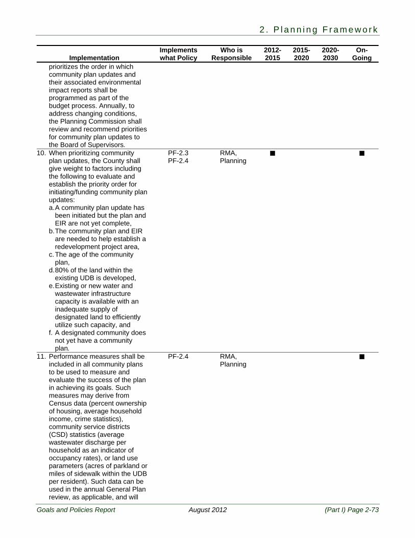
prioritizes the order in which community plan updates and their associated environmental impact reports shall be programmed as part of the budget process. Annually, to address changing conditions, the Planning Commission shall review and recommend priorities for community plan updates to the Board of Supervisors.
10. When prioritizing community plan updates, the County shall give weight to factors including the following to evaluate and establish the priority order for initiating/funding community plan updates: a. A community plan update has
been initiated but the plan and EIR are not yet complete,
b. The community plan and EIR are needed to help establish a redevelopment project area,
c. The age of the community plan,
d. 80% of the land within the existing UDB is developed,
e. Existing or new water and wastewater infrastructure capacity is available with an inadequate supply of designated land to efficiently utilize such capacity, and
f. A designated community does not yet have a community plan.
PF-2.3 PF-2.4
RMA, Planning
11. Performance measures shall be included in all community plans to be used to measure and evaluate the success of the plan in achieving its goals. Such measures may derive from Census data (percent ownership of housing, average household income, crime statistics), community service districts (CSD) statistics (average wastewater discharge per household as an indicator of occupancy rates), or land use parameters (acres of parkland or miles of sidewalk within the UDB per resident). Such data can be used in the annual General Plan review, as applicable, and will
PF-2.4 RMA, Planning
T u l a r e C o u n t y G e n e r a l P l a n
(Part I) Page 2-74 August 2012 Goals and Policies Report
Implementation Implements what Policy
Who is Responsible
2012-2015
2015-2020
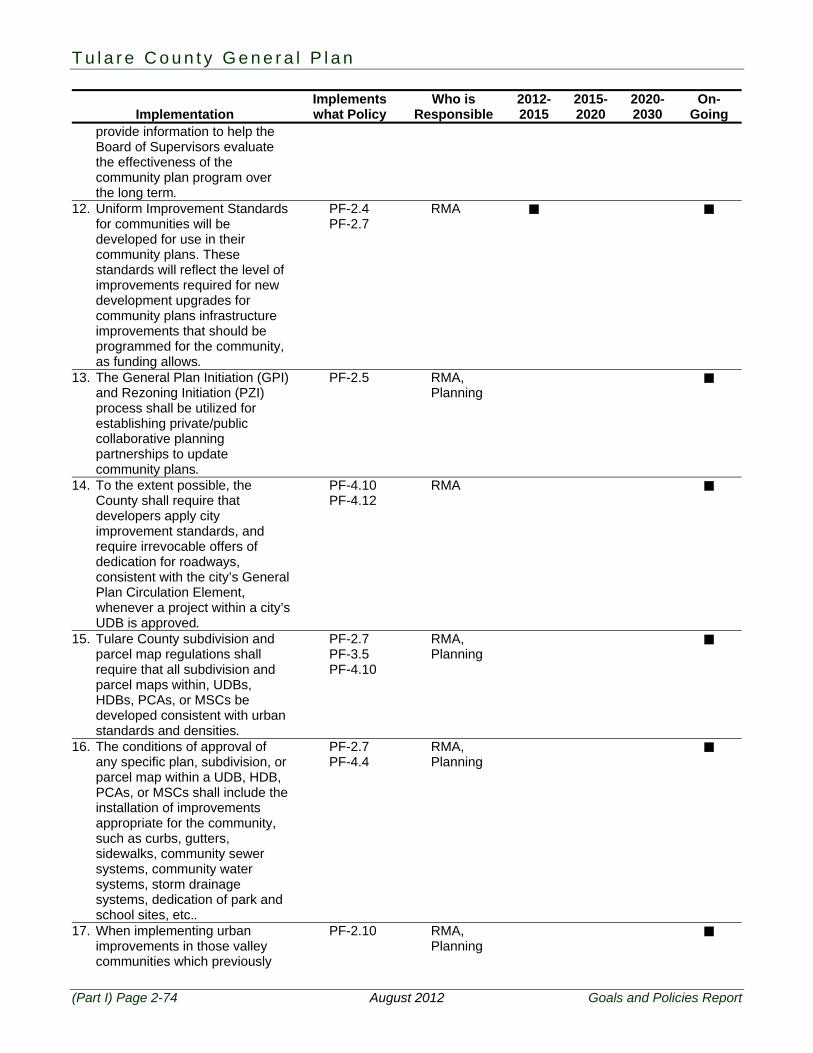
2020-2030
On-Going
provide information to help the Board of Supervisors evaluate the effectiveness of the community plan program over the long term.
12. Uniform Improvement Standards for communities will be developed for use in their community plans. These standards will reflect the level of improvements required for new development upgrades for community plans infrastructure improvements that should be programmed for the community, as funding allows.
PF-2.4 PF-2.7
RMA
13. The General Plan Initiation (GPI) and Rezoning Initiation (PZI) process shall be utilized for establishing private/public collaborative planning partnerships to update community plans.
PF-2.5 RMA, Planning
14. To the extent possible, the County shall require that developers apply city improvement standards, and require irrevocable offers of dedication for roadways, consistent with the city’s General Plan Circulation Element, whenever a project within a city’s UDB is approved.
PF-4.10 PF-4.12
RMA
15. Tulare County subdivision and parcel map regulations shall require that all subdivision and parcel maps within, UDBs, HDBs, PCAs, or MSCs be developed consistent with urban standards and densities.
PF-2.7 PF-3.5 PF-4.10
RMA, Planning
16. The conditions of approval of any specific plan, subdivision, or parcel map within a UDB, HDB, PCAs, or MSCs shall include the installation of improvements appropriate for the community, such as curbs, gutters, sidewalks, community sewer systems, community water systems, storm drainage systems, dedication of park and school sites, etc..
PF-2.7 PF-4.4
RMA, Planning
17. When implementing urban improvements in those valley communities which previously
PF-2.10 RMA, Planning
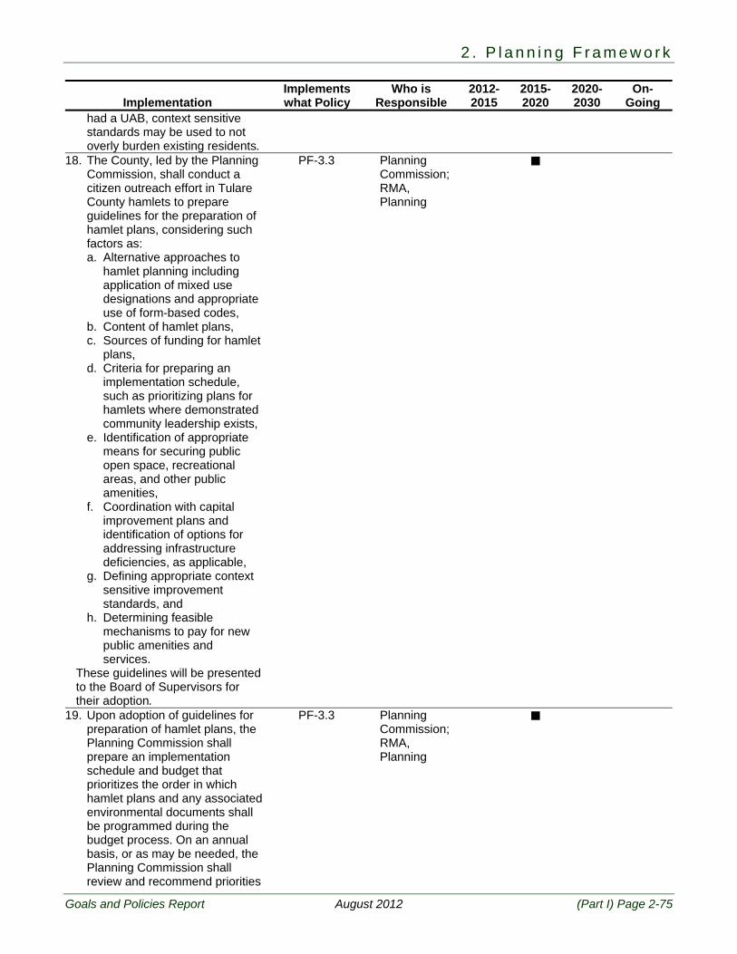
2 . P l a n n i n g F r a m e w o r k
Goals and Policies Report August 2012 (Part I) Page 2-75
Implementation Implements what Policy
Who is Responsible
2012-2015
2015-2020
2020-2030
On-Going
had a UAB, context sensitive standards may be used to not overly burden existing residents.
18. The County, led by the Planning Commission, shall conduct a citizen outreach effort in Tulare County hamlets to prepare guidelines for the preparation of hamlet plans, considering such factors as: a. Alternative approaches to
hamlet planning including application of mixed use designations and appropriate use of form-based codes,
b. Content of hamlet plans, c. Sources of funding for hamlet
plans, d. Criteria for preparing an
implementation schedule, such as prioritizing plans for hamlets where demonstrated community leadership exists,
e. Identification of appropriate means for securing public open space, recreational areas, and other public amenities,
f. Coordination with capital improvement plans and identification of options for addressing infrastructure deficiencies, as applicable,
g. Defining appropriate context sensitive improvement standards, and
h. Determining feasible mechanisms to pay for new public amenities and services.
These guidelines will be presented to the Board of Supervisors for their adoption.
PF-3.3 Planning Commission; RMA, Planning
19. Upon adoption of guidelines for preparation of hamlet plans, the Planning Commission shall prepare an implementation schedule and budget that prioritizes the order in which hamlet plans and any associated environmental documents shall be programmed during the budget process. On an annual basis, or as may be needed, the Planning Commission shall review and recommend priorities
PF-3.3 Planning Commission; RMA, Planning

T u l a r e C o u n t y G e n e r a l P l a n
(Part I) Page 2-76 August 2012 Goals and Policies Report
Implementation Implements what Policy
Who is Responsible
2012-2015
2015-2020
2020-2030
On-Going
for hamlet plan preparation to the Board of Supervisors.
20. The County shall explore all available options to fund necessary improvements such as: establishment of redevelopment project areas, revenue sharing, formation of assessment districts, development agreements, Community Development Block Grant (CDBG) funds, grants, etc., as part of the plan development process.
PF-1.2 PF-3.3
RMA
21. The County shall amend its Zoning Ordinance to add mixed use zones based on smart growth and neo-urban principles.
PF-2.9 PF-3.4
RMA, Planning
22. The County shall minimize potential land use conflicts at the interface between urban development, as well as upgrades that should be planned for the hamlet, as funding allows. The County shall continue to support community and hamlet efforts to secure State and Federal funding and pursue Community Development Block Grants.
PF-3.5 RMA, Planning
23. As part of the annual budget process the County shall place a priority on maintaining close consistency between city and County 20 year boundaries, provided boundary updates and materials are submitted to the County in a timely fashion.
PF-4.2 RMA, Planning
24. The County shall, when evaluating city General Plans for adoption, consider evidence provided that any proposed boundary expansion minimizes conversion of agricultural land by demonstrating that at least 80% of the non-Williamson Act Land within the existing UDB is developed with urban uses.
PF-4.6 RMA, Planning
25. The County shall work with the cities to develop a streamlined process for review of city General Plan updates and amendments.
PF-4.6 RMA, Planning
26. To the extent possible, the PF-4.7 RMA,
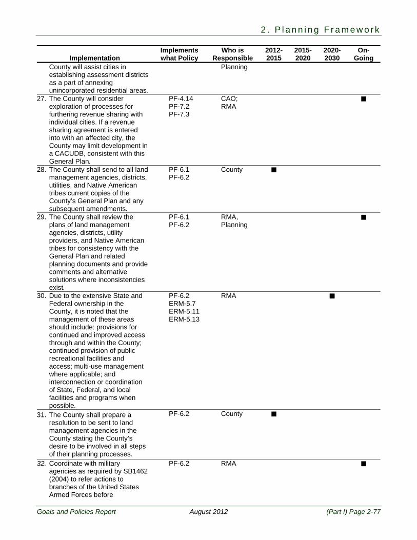
2 . P l a n n i n g F r a m e w o r k
Goals and Policies Report August 2012 (Part I) Page 2-77
Implementation Implements what Policy
Who is Responsible
2012-2015
2015-2020
2020-2030
On-Going
County will assist cities in establishing assessment districts as a part of annexing unincorporated residential areas.
Planning
27. The County will consider exploration of processes for furthering revenue sharing with individual cities. If a revenue sharing agreement is entered into with an affected city, the County may limit development in a CACUDB, consistent with this General Plan.
PF-4.14 PF-7.2 PF-7.3
CAO; RMA
28. The County shall send to all land management agencies, districts, utilities, and Native American tribes current copies of the County’s General Plan and any subsequent amendments.
PF-6.1 PF-6.2
County
29. The County shall review the plans of land management agencies, districts, utility providers, and Native American tribes for consistency with the General Plan and related planning documents and provide comments and alternative solutions where inconsistencies exist.
PF-6.1 PF-6.2
RMA, Planning
30. Due to the extensive State and Federal ownership in the County, it is noted that the management of these areas should include: provisions for continued and improved access through and within the County; continued provision of public recreational facilities and access; multi-use management where applicable; and interconnection or coordination of State, Federal, and local facilities and programs when possible.
PF-6.2 ERM-5.7 ERM-5.11 ERM-5.13
RMA
31. The County shall prepare a resolution to be sent to land management agencies in the County stating the County’s desire to be involved in all steps of their planning processes.
PF-6.2 County
32. Coordinate with military agencies as required by SB1462 (2004) to refer actions to branches of the United States Armed Forces before
PF-6.2 RMA
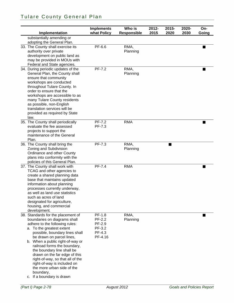
T u l a r e C o u n t y G e n e r a l P l a n
(Part I) Page 2-78 August 2012 Goals and Policies Report
Implementation Implements what Policy
Who is Responsible
2012-2015
2015-2020
2020-2030
On-Going
substantially amending or adopting the General Plan.
33. The County shall exercise its authority over private development on public land as may be provided in MOUs with Federal and State agencies.
PF-6.6 RMA, Planning
34. During periodic updates of the General Plan, the County shall ensure that community workshops are conducted throughout Tulare County. In order to ensure that the workshops are accessible to as many Tulare County residents as possible, non-English translation services will be provided as required by State law.
PF-7.2 RMA, Planning
35. The County shall periodically evaluate the fee assessed projects to support the maintenance of the General Plan.
PF-7.2 PF-7.3
RMA
36. The County shall bring the Zoning and Subdivision Ordinance and other County plans into conformity with the policies of this General Plan.
PF-7.3 RMA, Planning
37. The County shall work with TCAG and other agencies to create a shared planning data base that maintains updated information about planning processes currently underway, as well as land use statistics such as acres of land designated for agriculture, housing, and commercial development.
PF-7.4 RMA
38. Standards for the placement of boundaries on diagrams shall adhere to the following rules: a. To the greatest extent
possible, boundary lines shall be drawn on parcel lines,
b. When a public right-of-way or railroad forms the boundary, the boundary line shall be drawn on the far edge of this right-of-way, so that all of the right-of-way is included on the more urban side of the boundary,
c. If a boundary is drawn
PF-1.8 PF-2.2 PF-2.9 PF-3.2 PF-4.3 PF-4.16
RMA, Planning
2 . P l a n n i n g F r a m e w o r k
Goals and Policies Report August 2012 (Part I) Page 2-79
Implementation Implements what Policy
Who is Responsible
2012-2015
2015-2020
2020-2030
On-Going
parallel to a public right-of-way, and the source description does not specify “from the center line of the right-of-way”, then the boundary shall be drawn at the specified distance from the edge of the right-of-way. If no distance is explicitly specified, then judgment may be used to place the boundary line such that it is an extension of the property line dividing ‘near-by’ parcels,
d. When the Friant-Kern Canal forms the boundary, then the boundary is at the edge of the canal so that the canal is excluded from the smaller/more urban district,
e. When a water course forms the boundary, then the boundary is the far edge of the river at the high water mark so that the river is included within the more urban side of the boundary,
f. Whenever a UAB, UDB, HDB, or Regional Growth Corridors intersects a municipal services district (incorporated city, community service district, public utilities district, or County zone of benefit), then the planning area boundary shall be revised to include all of the municipal service district within the County boundary, and
g. Whenever a County planning boundary intersects an area of developed lots that are smaller than 0.5 acres, the planning boundary shall be adjusted to include such development within the planning district.
39. The County may work with any individual City to commence a review of the current land use designations and zoning districts applied in the CACUDBs with the goal of identifying, reviewing and possibly restricting, as appropriate and allowed by law,
PF-4.18 PF-4.20
RMA, Planning
T u l a r e C o u n t y G e n e r a l P l a n
(Part I) Page 2-80 August 2012 Goals and Policies Report
Implementation Implements what Policy
Who is Responsible
2012-2015
2015-2020
2020-2030
On-Going
any non-agricultural uses or non-agricultural supporting uses in the CACUDB. The goal of such work program may be to remove allowed or permitted uses from the current list of special uses within the CACUDB where such uses are more appropriately defined as urban or industrial uses, while still allowing the establishment of, or retaining, uses that are directly related to the agricultural industry and are important to be located in proximity to production agriculture.
40. The County may work with any individual city to pursue possible adoption of urban development standards in the CACUDB to be applied to projects approved as “agricultural related” allowed or permitted uses within the CACUDB, and coordination of such development with any County adopted long-range urban infrastructure plans of the affected city.
PF-4.10 PF-4.18 PF-4.20
RMA, Planning
41. The County and any individual city may commence a review of the current land use designations and zoning districts applied in the CACUAB with the goal of identifying, reviewing and possibly restricting, as appropriate and allowed by law, non-agricultural uses or non-agricultural supporting uses in the CACUAB. The goal of such work program may be to remove, or possibly restricting, allowed or permitted uses in the current list of special uses within the CACUAB where such uses are more appropriately defined as urban or industrial uses, while still allowing the establishment of, or retaining, uses that are directly related to the agricultural industry and are important to be located in proximity to production agriculture.
PF-4.19 PF-4.21
RMA, Planning
42. The County may work with an individual city to pursue possible County adoption of any long-
PF-4.12 PF-4.17
RMA, Planning
2 . P l a n n i n g F r a m e w o r k
Goals and Policies Report August 2012 (Part I) Page 2-81
Implementation Implements what Policy
Who is Responsible
2012-2015
2015-2020
2020-2030
On-Going
range urban infrastructure plans of the city in order to provide for appropriate transportation and utility corridors in the CACUAB.
43. If a city proposes, provides evidence to support, pays the County costs of consideration and adoption (including but not limited to staff time, notice and hearing costs) and agrees to hold harmless, defend and indemnify the County in any challenge to, the adoption or implementation of changed County regulations, land use, or boundaries under Policies PF-4.14, the County shall consider such proposals.
PF-4.17 PF-4.18 PF-4.19 PF-4.20 PF-4.21 PF-4.22 PF-4.23 PF-4.24 PF-4.25 PF-4.26 PF-4.27
RMA, Planning
44. If a city proposes, provides evidence to support (including the nexus study), pay the County costs of consideration and adoption (including but not limited to staff time, notice and hearing costs), negotiates and enters into a fee participation agreement with the County and agrees to hold harmless, defend and indemnify the County in any challenge to the County adoption and collection of Development Impact Fees within the CACUDB for city facilities, the County will consider such proposal. Under such a program: a. To the extent allowed by law,
the impact fees imposed by the city in the city will be equal to or be consistent with the impact fees proposed by the city for collection by the County
b. The city must agree to take all steps necessary to comply with, and assist the County in complying with, the Mitigation Fee Act.
c. As required by the Mitigation Fee Act, Chapter 5, Government Code sections 66000 et seq., the city will provide a nexus study that identifies the purpose of the fee and identifies the use to which the fee will to be put,
PF-4.14 PF-4.27
RMA, Planning
T u l a r e C o u n t y G e n e r a l P l a n
(Part I) Page 2-82 August 2012 Goals and Policies Report
Implementation Implements what Policy
Who is Responsible
2012-2015
2015-2020
2020-2030
On-Going
including the public facilities to be financed.
d. Reciprocally and under the same conditions, the city will consider the collection of Development Impact Fees within the city to offset the impact of development within the city on County facilities..