2. Country: Nicaragua - Ramsar · birds, there are the American harpy eagle (Harpia harpyja) and...
23
1 DISCLAIMER : Translated from the original Spanish for the Ramsar Bureau (August 2002), and provided to Wetlands International for use in the Ramsar Database. Translation not checked against original by Ramsar Bureau. Information Sheet on Ramsar Wetlands 1. Date this sheet was completed/updated: July 2000 2. Country: Nicaragua 3. Name of wetland: Río San Juan Wildlife Reserve 4. Geographical coordinates: 10º 09' 56" - 10º 58' 38" North latitude 83º 46’ 38" - 84º 20' 25" East longitude This wetland is defined by boundaries that begin at Río Bartola at 10º 58' 22" North latitude and 84º 20' 25" West longitude. The boundary continues downriver along Río San Juan on the shore that marks the border with Costa Rica to the Caribbean Sea at 10º 55' 56" North latitude and 83º 40' 02" West longitude. At this point, it continues north along the coast to 10º 09' 56" North latitude and 83º 50' 50" West longitude until meeting the Río San Juanillo at 10° 56’ 28" North latitude and 83° 44’ 53" West longitude. It then follows the edge of the wetland until reaching Lake Sílico at 10º 51' 58" North latitude and 83º 44' 53" West longitude and then along the contour line of 10 metres above sea level until reaching 10º 48' 50" North latitude and 83º 43' 58" West longitude. It then continues southwest, two kilometres from Río San Juan, along the southern bank of Río Bartola until 10º 58' 38" North latitude and 84º 20' 22" West longitude (where this description began) (MARENA, 1999). 5. Altitude: 20 metres above sea level 6. Area: 43,000 hectares 7. Overview: The Río San Juan Wildlife Reserve forms part of one of the two largest, best-preserved biological nucleuses of the Mesoamerican Biological Corridor and forms one of the most important wetlands in Central America because it is the final stage of the largest water basin in Central America on a low fluvial-marine plain with average elevations of 20 metres above sea level and slopes of less than 0.5 per cent. Its landscape is morphological deltas, low river dikes, marshes and beach bars, all moderately well-to-poorly drained. This combined with high precipitation in the area results in the soil remaining saturated with water. The lacustrine complex is made up of several lakes that are interconnected by a multitude of small ponds through a tangled system of rivers that downstream supply the basin of freshwater populations and life cycles. All these bodies of water drain very slowly into Río San Juan, which then empties into the Atlantic Ocean. These characteristics are the logical consequence of the gradual slope of Río San Juan,
Transcript of 2. Country: Nicaragua - Ramsar · birds, there are the American harpy eagle (Harpia harpyja) and...

1
DISCLAIMER : Translated from the original Spanish for the Ramsar Bureau (August 2002), and provided toWetlands International for use in the Ramsar Database. Translation not checked against original by RamsarBureau.
Information Sheet on Ramsar Wetlands
1. Date this sheet was completed/updated: July 2000
2. Country: Nicaragua
3. Name of wetland: Río San Juan Wildlife Reserve
4. Geographical coordinates:
10º 09' 56" - 10º 58' 38" North latitude83º 46’ 38" - 84º 20' 25" East longitude
This wetland is defined by boundaries that begin at Río Bartola at 10º 58' 22" Northlatitude and 84º 20' 25" West longitude. The boundary continues downriver alongRío San Juan on the shore that marks the border with Costa Rica to the CaribbeanSea at 10º 55' 56" North latitude and 83º 40' 02" West longitude. At this point, itcontinues north along the coast to 10º 09' 56" North latitude and 83º 50' 50" Westlongitude until meeting the Río San Juanillo at 10° 56’ 28" North latitude and 83° 44’53" West longitude. It then follows the edge of the wetland until reaching Lake Sílicoat 10º 51' 58" North latitude and 83º 44' 53" West longitude and then along thecontour line of 10 metres above sea level until reaching 10º 48' 50" North latitude and83º 43' 58" West longitude. It then continues southwest, two kilometres from Río SanJuan, along the southern bank of Río Bartola until 10º 58' 38" North latitude and 84º20' 22" West longitude (where this description began) (MARENA, 1999).
5. Altitude: 20 metres above sea level
6. Area: 43,000 hectares
7. Overview: The Río San Juan Wildlife Reserve forms part of one of the two largest,best-preserved biological nucleuses of the Mesoamerican Biological Corridor andforms one of the most important wetlands in Central America because it is the finalstage of the largest water basin in Central America on a low fluvial-marine plain withaverage elevations of 20 metres above sea level and slopes of less than 0.5 percent. Its landscape is morphological deltas, low river dikes, marshes and beach bars,all moderately well-to-poorly drained. This combined with high precipitation in thearea results in the soil remaining saturated with water.
The lacustrine complex is made up of several lakes that are interconnected by amultitude of small ponds through a tangled system of rivers that downstream supplythe basin of freshwater populations and life cycles. All these bodies of water drainvery slowly into Río San Juan, which then empties into the Atlantic Ocean. Thesecharacteristics are the logical consequence of the gradual slope of Río San Juan,

2
which begins in Lake Nicaragua at an altitude of 32 metres and flows for 200kilometres until reaching Bahía de San Juan del Norte at sea level and then theCaribbean. At the point where the sea and freshwater join is one of the mostproductive ecosystems: the mangroves whose function and permanence are key tothe stability of the life cycles of many aquatic species.
8. Wetland type: The Río San Juan Wildlife Reserve has a large variety of habitats,both marine/coastal and inland:
Marine/coastal wetlands: (In order of increasing importance)
K: Coastal freshwater lagoons; includes freshwater delta lagoons
A: Permanent shallow marine waters in most cases less than six metres deep at lowtide; includes sea bays and straits
F: Estuarine waters; permanent water of estuaries and estuarine systems of deltas
H: Intertidal marshes; includes salt marshes, salt meadows, saltings, raised saltmarshes; includes tidal brackish and freshwater marshes
I: Intertidal forested wetlands; includes mangrove swamps, nipah swamps and tidalfreshwater swamp forests
E: Sand (guijarros), shingle or pebble shores; includes sand bars, spits and sandyislets; includes dune systems and humid dune slacks
Inland wetlands (In order of increasing importance)
O: Permanent freshwater lakes (more than eight hectares); includes large oxbowlakes
M: Permanent rivers/streams/creeks
Y: Freshwater springs
Tp: Permanent freshwater marshes/pools; ponds (fewer than eight hectares),marshes and swamps on inorganic soils; with emergent vegetation water-logged forat least most of the growing season
W: Shrub-dominated wetlands; shrub swamps, shrub-dominated freshwatermarshes, shrub carr, alder thicket on inorganic soils
Xf: Freshwater, tree-dominated wetlands; includes freshwater swamp forests,seasonally flooded forests, wooded swamps on inorganic soils
U: Non-forested peatlands; includes shrub or open bogs, swamps, fens
L: Permanent inland deltas

3
Sp: Permanent saline/brackish/alkaline marshes/pools
9. Ramsar criteria: 1, 2, 3, 4, 5, 7 and 8
Criteria that best characterize the site: The most significant criterion is criterion 1because this wetland plays an important hydrological, biological and ecological role inthe natural functioning of a water basin because of its diversity of preserved habitatswith a rich biodiversity in excellent conservation status, including species that arevulnerable or endangered at other sites. It has a special value as habitat for plantsand animals during critical periods of their life cycle. In addition, this wetland servesas a biological corridor because it is a cross-border site between protected areas intwo countries and protects the survival of its inhabitants. Furthermore, this wetland isan example of the harmonious relationship between a wetland and fishing traditionsin the area, which contribute significantly to the economic and social development ofthe local communities.
10. Map of site included? Please tick yes -or- no
11. Name and address of the compiler of this form:
Lic. Rafael H. GarcíaAmigos de la Tierra-España
Lic. Arnulfo R. MedinaFundación Amigos del Río San Juan
de la Vicky de Altamira, 2 c. al sur 1c. arriba 1c. al surManaguaTel.: (505) 270 5434Fax: (505) 270 3561E-mail: [email protected]
12. Justification of the criteria selected under point 9, on previous page: The wetlandis considered of international importance because:
Criterion of representative wetlands
Criterion 1. Migratory marine species are of special importance because of theeconomy of the communities surrounding Río San Juan. Brackish water flowsthrough this refuge to the freshwater lake. There are several species of fish: tiburóntoro (Carcharinus leucas), tarpon (sábalo real) (Tarpon atlanticus), sea bass (róbalo)(Centropomus parallelus) and gaspar (Antractosteus tropicus), which provide food forthe human populations that live there.
The natural functions of the Río San Juan Wildlife Refuge are also of greatimportance. This is the youngest geological area in Central America, functioning asan evolutionary bridge for the continent’s fauna and flora. Its ecological importancelies in its diversity of ecosystems and habitats, forming part of one of the largesthumid tropical ecosystems in Central America (Amigos de la Tierra, 1999).

4
This wetland plays a hydrological role of great importance by the fact that it is locatedat the mouth of a large river basin that allows this area to gather most of thesediments and nutrients from the two countries that share this basin. Likewise, thewetland acts as a regulator of streams, controlling flooding and extracting pollutionfrom the water. It provides drinking water and a refuge for diverse wildlife and offersopportunities for transportation for several purposes (INETER, 1990).
Its ecological and biological importance is based on its wild state, which is importantfor two reasons, which reflect the diversity of the natural resources present: thediversity of ecosystems and species. This reserve still maintains natural resources inan excellent conservation status, although there are several natural spaces inregeneration because of previous human intervention (Amigos de la Tierra, 1999).Taking into account these considerations, we can deduce that the wetland is anespecially good representative example because it plays an important hydrological,biological and ecological role and especially because it is cross-border.
General criteria based on fauna and flora
Criterion 2. Many of the terrestrial and aquatic species that are found in this wetlandcan be considered as the basis for its importance. Among them are fish such as thetiburón toro (Carcharinus leucas), tarpon (sábalo real) (Tarpon atlanticus), sea bass(róbalo) (Centropomus parallelus) and gaspar (Antractosteus tropicus) as well aslarge mammals such as the white-lipped peccary (chancho de monte) (Tayassupecari), Baird’s tapir (Tapirus bairdii), American manatee (Trichechus manatus),jaguar (Panthera onca) and giant anteater (Myrmecophaga tridactyla). Among thebirds, there are the American harpy eagle (Harpia harpyja) and pájaro campana(Procnias tricarunculata) and two species of macaws considered to be endangered:the scarlet macaw (Ara macao) and Buffon’s macaw (Ara ambigua). It is alsoimportant to mention the presence of sea turtles: the hawksbill turtle (Eretmochelysimbricata), leatherback (Dermochelys coriacea), green turtle (Chelonya mydas) andloggerhead (Caretta caretta); all endangered species (Zúñiga et. al., 1996).
Among the local vegetation that justify the site’s importance are communities ofepiphytes, such as the orchids and bromeliads, as well as several palms andAraceae. It is important to mention large trees species sought after for theirecological and economic value, such as: Carapa guianensis, Dipterix panamensis,Ficus sp., Manilkara zapota, Pentaclethra macroloba, Pterocarpus officinalis,Simarouba sp., Tabebuia sp. and Terminalia sp.
This wetland sustains a diversity of important fauna. In a preliminary survey, 303species of birds (24 migratory), 26 mammals, 15 reptiles, 3 amphibians and 61species of insects were recorded. In addition, seven marine crustaceans and twofreshwater species have been identified (Amigos de la Tierra, 1999). Just thepresence of species extinct in other parts of the world justifies protection of manywildlife reserves in the world. An international agreement, ratified by Nicaragua in1977 (La Gaceta, Diario Oficial No. 183), obliges us to take into account the speciesidentified in the Appendices Convention on International Trade in EndangeredSpecies of Wild Fauna and Flora (CITES) and regulate their trade. In this wildliferefuge, there are 46 of these species in significant numbers.

5
Criterion 3. Because it is a wildlife area in excellent conservation status and naturalquality, this wetland has special importance for conservation of genetic andecological diversity. It is of special importance for species endemic to CentralAmerica in general and the basin of Río San Juan in particular, such as thepopulations of orchids that are found in the area. Many of these orchids are endemicto the virgin forests of Central America, for example, Epidendrum circinatum, E.hawkesii, Gongora sp., Maxillaria dresleriana and Stanhopea ecornuta (Díaz, 2000).
Criterion 4. For migratory species, this wetland is of special importance as a habitatduring a critical period of their life cycles, primarily because it provides sites fordispersion and reproduction for many species of fish and crustaceans that live there.A clear example is the lobster (Panalirus argus), which emigrates along the coastnorth of the wetland (the Caribbean coast) until reaching the continental platform atSan Juan del Norte in search of breeding areas (Robleto, 1996). The wetland alsoprovides refuge and feeding for a considerable community of migratory birds fromNorth America. Up until now, a total of 22 species of marine birds have beenidentified, some of which remain in these ecosystems until their departure (Zúñiga etal., 1996).
Specific criteria based on waterfowl (It is important to mention that although there arestill no studies that quantify these criteria, recent observations in field surveyssupport the veracity of these criteria.)
Criterion 5. Although there are no studies that support this criterion, it is knownthrough rapid environmental assessments made in the area that the marine birdpopulations are stable, with a large expected variety of species still not surveyed.Among the most common marine bird populations are the pato aguja (Anhingaanhinga) and pato chancho (Phalacrocorax olivaceus). Kingfishers are also verycommon along the rivers. There are four species of kingfisher in the area: Cerylealcyon, C. torquata, Chloroceryle amazona and C. americana. One species,Chloroceryle inda, has not yet been recorded, but it has been reported insoutheastern Nicaragua, the northern limit of its distribution. Herons are verycommon in many bodies of water in the reserve. Among them are the garceta azul(Egretta caerulea), great egret (Casmerodius albus), garza blanca pequeña (Egrettathula) and garza morena (Ardea herodias) (a migratory bird). Two especiallypicturesque species are the patito de agua (Heliornis fulica) and Muscovy duck (patoreal) (Cairina moschata). The swallows (Tachicyneta albilinea and Notiochelidoncyanoleuca) are migratory and are present along Río San Juan (Zúñiga et. al., 1996).This wetland regularly sustains a significant number of specimens of certain groupsof aquatic birds such as those described earlier.
Specific criteria based on fish
Criterion 7. Preliminary results obtained through a rapid environmental assessment ofthe diversity of fish resources identified 32 species of fish and crustaceans in eightfamilies that contribute to the world’s biological diversity (Robleto, 1996). In thisreserve, there is the freshwater shrimp Macrobrachium carcinus, which is one of thelargest species of freshwater prawn in the world. As a result, it has a great exportpotential that is still little exploited. It reproduces in brackish waters and migrates forgrowth to several riparian environments. Until now, four species of Caribbean shrimp

6
(Panaeus spp.) have been identified, which also reproduce in the brackish waters ofthe mangroves in this reserve and serve as food for the local inhabitants. Thisexploitation still has little impact on the conservation status of the reserve. However,future population trends are alarming and could begin to have a negative impact onthe wetland (Amigos de la Tierra, 1999).
Criterion 8. Among the migratory species that are captured during several months ofthe year in San Juan del Norte are sea bass (róbalo) (Centropomus parallelus),lobster (Panalirus argus), calvas (Centropomus pectinatus), tiburón toro (Carcharinusleucas), tarpon (sábalo real) (Tarpón atlanticus) and gaspar (Antractosteus tropicus).These species use Río San Juan as a migration route (Amigos de la Tierra, 1999).
13. General location: This wetland is located in the extreme south-eastern part ofNicaragua, bordering on Costa Rica. Administratively, the Río San Juan WildlifeReserve forms part of the department of Río San Juan and the Región AutónomaAtlántico Sur (RAAS). This refuge is located in parts of three municipios: San Juandel Norte, El Castillo and Bluefields, of which two belong to the department of RíoSan Juan–the municipio of San Juan del Norte (85.67 per cent) and the municipio ofEl Castillo (13.21 per cent). Likewise, it is in a small portion of the municipio ofBluefields (0.67 per cent), belonging to the RAAS. These percentages have beencalculated including the offshore strip of three nautical miles in the Caribbean(Amigos de la Tierra, 1999).
In the Río San Juan Wildlife Reserve, near the mouth of Río Indio, San Juan delNorte is the only populated centre within the refuge with a total population of 967rural and urban inhabitants (INIFOM, 1998 in Amigos de la Tierra, 1999).
14. Physical features:
Geology: In terms of geology, this area belongs to the part of the continent thatemerged relatively late. This determines not only its young geological origin but alsoits special biological richness. In general terms, its relief is rather flat because oftectonic orogenesis and its recent geological formation, emerging from thedepression of Lake Nicaragua in the Quaternary. This area is the result of one of thelast movements of the continental plates and is covered with volcanic material andfluvial-lacustrine sediments from the Quaternary (CATIE-UAW-MAG, 1995).According to the soil study of the Southeast by the Office of Land Registry andNatural Resources (Catastro, 1978 in INETER, 1990), there are the following fourmain geological formations:
(a) A colluvial-fluvial formation on the Atlantic coastal plain and to the north andsouth of El Castillo;
(b) The Machuca formation of sedimentary rocks from the Eocene Tertiary to theeast of El Castillo and north of San Juan del Norte in the basins of the Indioand Maíz rivers;
(c) An undifferentiated pyroclastic and lava formation of volcanic rock from theTertiary in a small area of the basin of the Río Indio (Cerro El Diablo) and thearea of Río San Juan;
(d) The Pre-Machuca Eocene formation from the Tertiary of sedimentary rocks inthe sector of Tambor Grande and Cerro El Diablo.
7
Geomorphology: From the point of view of geomorphology, this wetland is dominatedby areas of fluvial origin. In addition, there are several low hills and coastal areas(Amigos de la Tierra, 1999). Because of the origin of the land in the Río San Juanbasin, many of the observations that explain the origin of the Norte region of CostaRica are applicable to the origin of the land in the Río San Juan Wildlife Reserve.Thus, in the middle Río San Juan there are sedimentary and volcanic rocks from theTertiary, formed by marine and several continental sediments with alternations ofvolcanic rocks of the Machuca formation from the Oligocene. There are alsosedimentary rocks from the Pliocene-Pleistocene that include materials of greatheterogeneity in size and nature. These rocks are formed primarily by colluvial-alluvial and fluvial-lacustrine materials from the Pleistocene. The colluvial-alluvialmaterial appears in the form of raised terraces. The Programa Zona Atlántica deCosta Rica (1995) identified two geomorphologic units: in the area of the Río SanJuan Wildlife Reserve, alluvial fans, recent fluvial plains, Pleistocene dissected fluvialfloodplain and in coastal areas, coastal bars and marshes (bogs) (CATIE-UAW-MAG,1995).
Origin of the wetland: Natural
Hydrology: The Río San Juan Wildlife Reserve is a large hydrological network formedby the lower parts of the Nicaraguan basin of Río San Juan, the largest water basinin Central America. The most important hydrological characteristic of this area is thepresence of Río San Juan, which begins in the extreme south-eastern part of LakeNicaragua and empties into the Caribbean Sea, forming a shifting delta. Anotherseries of wetlands runs parallel to the lower part of Río Indio joining with the yolillalesof Río Colorado (Costa Rica) in the Río San Juan delta. There are two basichydrological components that influence this reserve: Río San Juan and theCaribbean Sea. In addition, there is the system of lakes Ebo and Sílico and severalsmaller lakes, whose extraordinary beauty creates one of the most importantecological and scenic values of the area (Amigos de la Tierra, 1999).
Hydrological balance (annual averages) and total runoff of Río San Juan
1 Precipitation 2 Evapotranspiration 3 Total runoff (EST) 4 InfiltrationBasin mm/y 106m³/y mm/y % P 106m³/y mm/y % P 106m³/y mm/y % P 106m³/yR.S.J 1,860 55,472 924 50 % 27,557 780 42 % 26,262 156 8 % 4,652
Observations:
1 Average annual precipitation (INETER–IRENA)2 Average annual real evaporation (INETER–IRENA)3 Total runoff calculated on the basis of infiltration4 Average annual infiltration, estimated from geomorphological, climatological andgeological data.I InfiltrationEST Total runoffETR Real evapotranspirationP Average annual precipitation in millimetres per year% P Coefficient of infiltration (considered inversely proportional to the precipitation)

8
Types of soil and depth of the water table: INETER (1990) carried out a survey of soiltypes in the area surrounding San Juan del Norte and on the edges of Río San Juanabout 104 kilometres from San Carlos up to the two mouths on Río Indio, making thefollowing observations.
Place Texture Colour Depth of the water table (cm)Viejo San Juan del Norte sandy brown 80–100Nuevo San Juan del Norte(bank of the Río Indio)
sandy brown 85–100
Dos Bocas (Río Indio) Silty clay grey 30Boca del Sarapiquí clay brown --
Supply and drainage of water: The average volume of Río San Juan is estimated at1308 cubic metres/second at the mouth of Río Sarapiquí to which the contribution ofLake Nicaragua at the origin of Río San Juan is approximately 475 cubicmetres/second. That volume increases up to the mouth of Río Sarapiquí to 833cubic metres/second. Of the 833 cubic metres/second, 85 per cent (708 cubicmetres/second) are supplied by the Costa Rican basins and the remaining 15 percent (125 cubic metres/second) originate in Nicaragua.
The Río San Juan subsystem has an annual runoff in seasons of low water, fromFebruary to April, of 106 millimetres and a maximum of 295 millimetres in July andAugust. These values have been estimated based on precipitation and byextrapolating runoff to estimated areas. The volume increases considerably in RíoSarapiquí, reflecting the contribution of the large rivers of San Carlos and Sarapiquí.The maximum average monthly flow is almost three times the average minimummonthly. About 67 per cent of the volume is created in the portion of the basinbetween the stations of El Castillo and Sarapiquí and 74 per cent between SanCarlos and Sarapiquí. In this part, runoff reaches 2400 millimetres, which indicatesthat average precipitation should be between 3600 and 3900 millimetres(OAS/UNEP, 1997).
Soils types and chemical characteristics: The soils in the region are characterized bytheir acidity, clay texture and low fertility. According to a study made by IRENA (1992in Amigos de la Tierra, 1999), soils in the region can be divided into 11 types. Thedominant types of soils (78 per cent of the area) are:
Type A – Vertic tripaquerps: Deep with imperfect drainage, slopes between 0and 4 per cent, medium to low fertility. They are found in 8 per cent of theregion.
Type D – Dystropeptic tropodults: These are deep, well-drained soils, withslopes between 2 and 15 per cent, with a moderate to strong degree oferosion and medium to low fertility. They cover 17 per cent of the area.
Type E – Typic tropodults and Typic tropohumults: Deep or very deep well-drained soils, whose slopes vary between 15 and 50 per cent, with medium tolow fertility. They cover 53 per cent of the region.

9
This study identified various levels of soil erosion through photo interpretation, findinglight erosion in 48 per cent of the area in the form of laminate erosion and moderateerosion in 7 per cent of the soils in areas with slopes of 25 to 70 per cent. Finally,severe erosion (formation of furrows or rills) was identified in 18 per cent of the totalarea studied.
Water quality (physical and chemical characteristics)
Analysis of the water in the Río San Juan subsystemRiver pH Conductivity
(µs/cm)Turbidity(UNT)
STD Iron Totalphosphorous
Hardness
Left bank of Río San JuanMelchora(a)(b)
8.257.99
392284
A160
284.47197.64
0.360.73
0.0460.033
151.45 90.10
Bartola(a)(b)
7.688.04
104233
A260
78.41157.46
0.271.02
0.0270.023
37.00 70.05
Right bank of Río San JuanSarapiquí(a)(b)
7.458.01
159209
200180
95.54141.45
2.961.14
0.0600.035
62.65 62.65
Delta(a) 7.63 166 400 117.09 4.46 0.076 52.05
Source: Report on the Physical-Chemical Characteristics of the Water of Río SanJuan and Its Tributaries (CIRA/UNAN, 1994 in INETER, 1990).
( ) Sampling points; A: Abnormal data; Units of dissolved solids, iron, totalphosphorous and hardness in mg/l.
INETER (1990) carried out a study of water quality with analysis physical andchemical characteristics. For this purpose, water samples were taken at two sites ofinterest: Point 1 - Well in the former San Juan del Norte and Point 2 - Río Indio(Current San Juan del Norte)
The following results were obtained.
Parameter Point 1 Point 2pH 7.03 6.40(K) Potassium 9.00 mg/1 0.80 mg/1(Na) Sodium 7.70 mg/1 5.00 mg/1(Mg) Magnesium 2.61 mg/1 1.31 mg/1(Ca) Calcium 28.85 mg/1 2.15 mg/1(Fe) Iron 2.06 mg/1 0.98 mg/1(NO3) Nitrate 0.84 mg/1 0.84 mg/1(NO2) Nitrite 0.62 mg/1 0.05 mg/1(Cl) Chlorine 7.71 mg/1 7.71 mg/1(F) Fluor 0.01 mg/1 0.01 mg/1(SO4) Sulphate 1.16 mg/1 1.17 mg/1
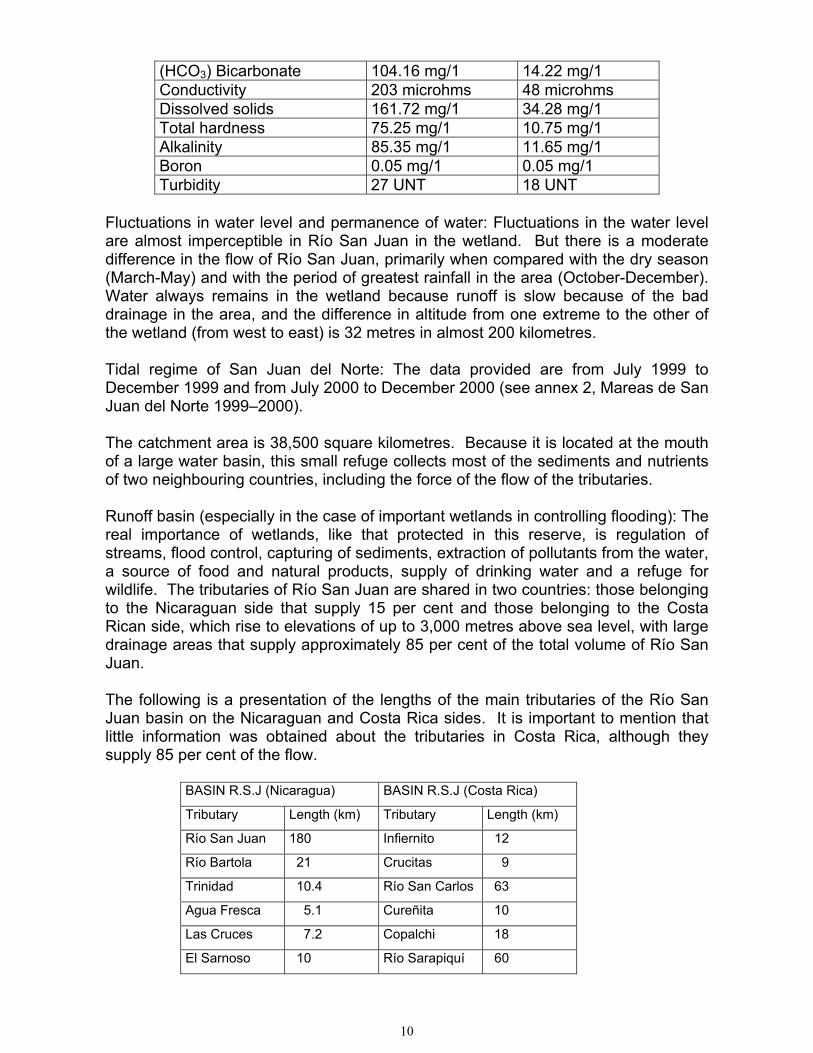
10
(HCO3) Bicarbonate 104.16 mg/1 14.22 mg/1Conductivity 203 microhms 48 microhmsDissolved solids 161.72 mg/1 34.28 mg/1Total hardness 75.25 mg/1 10.75 mg/1Alkalinity 85.35 mg/1 11.65 mg/1Boron 0.05 mg/1 0.05 mg/1Turbidity 27 UNT 18 UNT
Fluctuations in water level and permanence of water: Fluctuations in the water levelare almost imperceptible in Río San Juan in the wetland. But there is a moderatedifference in the flow of Río San Juan, primarily when compared with the dry season(March-May) and with the period of greatest rainfall in the area (October-December).Water always remains in the wetland because runoff is slow because of the baddrainage in the area, and the difference in altitude from one extreme to the other ofthe wetland (from west to east) is 32 metres in almost 200 kilometres.
Tidal regime of San Juan del Norte: The data provided are from July 1999 toDecember 1999 and from July 2000 to December 2000 (see annex 2, Mareas de SanJuan del Norte 1999–2000).
The catchment area is 38,500 square kilometres. Because it is located at the mouthof a large water basin, this small refuge collects most of the sediments and nutrientsof two neighbouring countries, including the force of the flow of the tributaries.
Runoff basin (especially in the case of important wetlands in controlling flooding): Thereal importance of wetlands, like that protected in this reserve, is regulation ofstreams, flood control, capturing of sediments, extraction of pollutants from the water,a source of food and natural products, supply of drinking water and a refuge forwildlife. The tributaries of Río San Juan are shared in two countries: those belongingto the Nicaraguan side that supply 15 per cent and those belonging to the CostaRican side, which rise to elevations of up to 3,000 metres above sea level, with largedrainage areas that supply approximately 85 per cent of the total volume of Río SanJuan.
The following is a presentation of the lengths of the main tributaries of the Río SanJuan basin on the Nicaraguan and Costa Rica sides. It is important to mention thatlittle information was obtained about the tributaries in Costa Rica, although theysupply 85 per cent of the flow.
BASIN R.S.J (Nicaragua) BASIN R.S.J (Costa Rica)
Tributary Length (km) Tributary Length (km)
Río San Juan 180 Infiernito 12
Río Bartola 21 Crucitas 9
Trinidad 10.4 Río San Carlos 63
Agua Fresca 5.1 Cureñita 10
Las Cruces 7.2 Copalchi 18
El Sarnoso 10 Río Sarapiquí 60

11
San Francisco 8 Marías 30
Tambor 8 Tigras 8
Tamborcito 3.5
La Danta 12
La Tigra 5
San Juanillo 47
Río Indio 70
Total 387.2 210
Total length of tributaries to the basin: 597.2 kilometres
Climate: Perhaps the most important characteristic of the Río San Juan basin is itshigh rainfall. In the distance that separates Lago Cocibolca from the sea,precipitation suddenly increases enormously from west to east from 1,400 to 6,300millimetres of annual precipitation at San Juan del Norte. This region has a wettropical climate. The rainy season is from May to January, and the dry season variesfrom three to four months, between February and May, with a minimum of rains inMarch (Amigos de la Tierra, 1999).
Winds: Winds normally blow from north to southeast. The strongest winds occurbetween December and February. Relative humidity in the rainiest months isbetween 90 and 95 per cent, and in the months of less rain it is above 60 per cent.Average temperatures are hot and range between 24° and 27º C, with the monthlyaverage varying by less than 3º C, without changing the pattern of the averagetemperature (Amigos de la Tierra, 1999).
15. Hydrological values:
The environmental factors that probably most influence the exuberant conditions inthis reserve are topography and humidity. This is the part of Nicaragua where rainfallis heaviest. It rains practically all year round. Furthermore, it is in the part of thecountry of least altitude in the final part of the largest water basin in Central America(38,500 square kilometres). Both factors promote frequent flooding and severelyrestrict the farming potential of this area (Amigos de la Tierra, 1996).
It is important to mention the role played by the basin in capturing sediments, somepollutants and nutrients from the two countries that share its basin. At the same time,the basin regulates surges and controls flooding. Supplying drinking water is alsoimportant for wildlife.
In addition, the extraordinary beauty of Sílico and Ebo lakes and several othersmaller lakes constitutes one of the most important scenic advantages that make thisreserve attractive for tourism and for migratory birds that stop here, connecting thesewetlands with others on their migratory route.
The importance of underground freshwater water pressure that circulates throughthis opening should not be ignored. It prevents salt water from intruding into theaquifers in the area. Restriction of the mouth of Río San Juan also decreases that

12
water pressure, which could invert the salinity gradient in relation to the undergrounddrinking water available for humans at San Juan del Norte, which is at only one metrein depth (Amigos de la Tierra, 1999).
16. Ecological features:
The reserve is itself a real laboratory because of its rich biodiversity, a result of theconcentration of migrations of wildlife from North America and the Amazon, andbecause it is the youngest region on the Central American isthmus (Saravia, 1996 inAmigos de la Tierra, 1999). Its condition as a biological bridge for the region has ledto a high potential for a large biodiversity in the rich natural aquatic and terrestrialecosystems.
Distribution of the ecosystems in the wildlife reserve depends on the relationshipbetween rainfall and drainage in this sedimentary soil, including some marineinfluence, as well as specific geographical aspects of a transitional ecosystem andwetland (Amigos de la Tierra, 1999).
The ecosystems observed in the Río San Juan Wildlife Reserve are the following:
Lowland tropical rain forest, IA1a, “lowland forest”Submontane tropical rain forest, IA1b, “upland forest”Tropical rain forest of dicotyledons, IA1h (1), “lowland forest”Tropical rain forest of palms, IA1h (2), “yolillal”Alluvial riparian tropical rain forest associated with areas of freshwater, IA1f(1),“gallery woodlands”Alluvial tropical rain forest, occasionally flooded, IA1f(2), “Gallery woodlands”Alluvial tropical rain forest, seasonally saturated, IA1f(3), “Gallery woodlands”Flooded wooded savannah, VA1e(1), “llanos”Floating predominantly herbaceous grasslands, VIIA1, “gamalotales”Marsh of Cyperaceae, mosses and similar with peat, VD1Mangrove, IA5, “mangrove”
Classification of these ecosystems is based primarily on criteria of plant compositionin the area and presence of several indicators of special environmental conditions(Ellenberg and Mueller-Dombois, 1974). Ecosystems in the Río San Juan WildlifeReserve are visibly characterized by the following.
Lowland tropical rain forest, IA1a, “lowland forest”: Composed of numerousspecies of rapid-growth trees, some exceeding 50 metres in height, usually withsmooth bark and tabular roots. Undergrowth is scarce and is made up ofpredominantly small replacement plants. The palms, shrubs and lianas are almosttotally absent, although there are pseudo-lianas (plants that germinate in branchesand later take root in the ground). Crustose lichens and blue-green algae are themost frequent life forms of epiphytes. Vascular epiphytes are less abundant. In thelowlands, vascular epiphytes are abundant where there is fog, for example near thecoasts.
Submontane tropical rain forest, IA1b, “upland forest”: The growth of trees issimilar to the previous case. The undergrowth is where there is the largest number

13
of herbaceous life forms. The most important difference is the greater frequency ofvascular epiphytes.
Tropical rain forest of dicotyledons, IA1h(1), “lowland forest”: This type hassurface deposits of organic material, is poor in species and has a canopy at fewerthan 20 metres. The trees are slow growing with small diameters and commonly withneumatophors and stilt roots. The broadleaf species are dominated by dicotyledons.
Tropical rain forest of palms, IA1h (2), “yolillal”: Similar to the previous but withdominance of palms with neumatophorous shoots.
Alluvial riparian tropical rain forest associated with areas of freshwater, IA1f(1),“gallery woodlands”: This type is located on the lower part of the riverbanks, oftenflooded. Dominated by trees of rapid growth, the herbaceous plants are almostabsent in the undergrowth and there are rare epiphytes; poor in number of species.
Alluvial tropical rain forest, occasionally flooded, IA1f(2), “gallery woodlands”:These are located on active high dry river terraces, similar to the life forms commonin tropical alluvial rain forests, but with more epiphytes and many lianas.
Alluvial tropical rain forest, seasonally saturated, IA1f(3), “gallery woodlands”:Located along rivers where water accumulates in wide plains for several months,there are trees with stilts. The canopy is not uniform, and undergrowth is poor,except in clearings.
Flooded wooded savannah, VA1e(1), “llanos”: Periodically flooded in severalpatterns of mosaic with palms or groups of trees on the highest places.
Floating predominantly herbaceous grassland, VIIA1, “gamalotales”: Made upof rooted or floating plants that tolerate or need a layer of water on the soil constantlyor for a large part of the year. Densely interwoven grasses and mosses permanentlycovering accumulations of freshwater. Most of the Spermatophytes are heliophytesand not true aquatic plants. They are dominated by Cyperaceae or rhizomorphgrasses. Camephytes and Spermatophytes can also be found.
Marsh of Cyperaceae, mosses and similar with peat, VD1: Open formations onland constantly or almost always flooded, with or without a few woody plants.Dominated by seasonally flooded Cyperaceae (gramineous, hemicryptophytes orgeophytes).
Mangrove, IA5, “mangrove”: Mangroves are found in the intertidal area and arecomposed almost entirely of trees and broadleaf evergreen sclerophyllous shrubswith stilt roots or neumatophors. Epiphytes are rare, except lichens on branches oralgae attached to the lower parts of trees.
After determining the characteristics of the various areas included in the Río SanJuan Wildlife Reserve and defining the most appropriate form of its distribution, wecan observe that the zonification proposed in the management plan of that area isnot defined only by aspects of the distribution of ecosystems. This can be explainedby the fact that until now distribution of those ecosystems within the area was

14
unknown. For this reason, only a level of ecosystems of mangrove, yolillal, aquaticnetwork, forest, riparian forest or marine coast have been used.
With additional information gathered in the field, we can now use new criteria toidentify the following areas, which earlier were considered homogeneous (Díaz,2000).
Area 1. Bahía de San Juan del Norte, with mangroves and vegetation in areaspermanently flooded with brackish water, made up of open forest and vegetation withthree strata. In sites where the soil is firmer, there is Pterocarpus officinalis within thetree stratum. The shrub stratum is dominated by Montricardia arborescens, and theherbaceous vegetation is made up of aquatic plants. These sectors are surroundedby gamalotales, and the bay is permanently flooded and slope is imperceptible.
Area 2. Caño El Cedro apparently forms the line of transition between the wetlands ofSan Juan del Norte and seasonally flooded forests with timber-producing specieswith a canopy of more than 20 metres. The forest is closed with an abundance ofepiphytes primarily of the Araceae family. In this sector, the lowland forests of theRío San Juan basin begin with dominance of Pentaclethra macroloba in the sub-canopy and palms in the undergrowth. These areas are seasonally flooded and ofsedimentary origin and slope is imperceptible.
Area 3. Yolillales along Río San Juan are formed by small patches of open forestformed mainly by yolillos scattered about in the lowland rain forest of Río San Juan.These areas are covered almost exclusively with Raphia taedigera. However, thereare dispersed specimens of Pentaclethra macroloba in the tree stratum. In the shrubstratum, there are several scattered specimens of Cyclanthus sp. andTabernaemontana sp. Among the herbaceous species, there are primarilyDieffenbachia sp. and Spathiphyllum sp, with several open areas dominated byGramineae. These sites are seasonally flooded and are of sedimentary origin andunconsolidated substratum with imperceptible slope.
Area 4. Yolillales in the area of San Juanillo are formed by closed seasonally floodedforest with emergent trees (Prioria copaifera) and undergrowth dominated by trees inthe genera Tabernaemontana and Morinda citrifolia. Herbaceous vegetation andepiphytes are not very abundant. These sites form a strip of sometimes floodedsedimentary land on unconsolidated substratum and with imperceptible slope.
Area 5. Permanently flooded yolillales to the west of San Juan del Norte, which arelarge areas of closed forest composed almost homogeneously of Raphia taedigerawith several very dispersed specimens of other tree species.
Area 6. Tidelands of Río Indio, Caño El Pescador and Top House, composed ofclosed forest with a dominance of a canopy of Raphia taedigera. At several sites, theundergrowth has predominantly Manicaria saccifera. At other sites, there is lechemaría (Calophyllum brasiliense) in relatively high densities, accompanied bySymphonia globulifera and Pterocarpus officinalis. At these sites, there are largeareas for conservation of tidelands.

15
Area 7. The area around lakes Ebo and Sílico is permanently flooded with sedimentsand unconsolidated substrata. The area is formed by an open forest that includes amosaic of ecosystems related to conditions of flooding. The vegetative coverincludes gamalotes, yolillos and permanently flooded forests with scattered low treeswith an impressive vascular and non-vascular epiphyte vegetation represented byseveral plant families, primarily Araceae, Bromeliaceae and Orchidaceae. This areaconnects on the west with part of the Indio-Maíz Biological Reserve, which in thatarea is an exuberant closed forest.
Area 8. The Indio-Maíz Biological Reserve to the west of Lake Sílico and Río Indioand contiguous to the Río San Juan Wildlife Reserve has a closed forest with acanopy dominated by Pentaclethra macroloba and lower strata with clear presence ofshade-tolerant palms and non-flooded sites. There are many epiphytes in this area,primarily species in the Araceae and Cyclanthaceae families. In the northern part ofthe Indio-Maíz Biological Reserve, there are signs of recent human disturbance fromselective cutting of timber. The reserve consists of hilly land with slopes of about 20degrees. The soil is reddish in colour.
Area 9. Tertiary forest in the foothills of the Río San Juan Wildlife Reserve has areaswith closed and open secondary forest, with several strata sometimes difficult todifferentiate. The most frequent arboreal species in the canopy in these forests isPentaclethra macroloba, in addition to several palms and other trees in the sub-canopy. The undergrowth is dominated by palms intolerant of shade. Slope rangesbetween 30 and 50 degrees, with several off-white incrustations in the soil. On theedge of Río San Juan, there are rocky outcroppings.
Area 10. Tacotales in the Río San Juan Wildlife Reserve along Río San Juan aremade up of scattered specimens of heliophyte species, a shrub stratum composed oflarge herbaceous species in the Costus and Heliconia genera and Calathea luteaand abundant Melastomataceae. Among the grasses, there are Gramineae andferns. There are also very abundant climbing species in several families. Thesubstratum is sedimentary and sometimes flooded.
Area 11. Coastal shore forms an area made up of unconsolidated sand substratum.The original vegetation has been removed, and coconuts (Cocos nucifera) are nowgrown here. Despite this, we can identify the following subdivisions in the beachprofile:
Intertidal area, made up of the area influenced by the tides;Sandy beach, sandy beachfront without terrestrial vegetation;An area of herbaceous terrestrial plants and creepers with an area ofherbaceous terrestrial vegetation;Areas of shrubs, shrub vegetation and heliophyte climbing plants;An area dominated by coconuts, coconut palms with the presence of plants ofthe underbrush and herbaceous species.
These abundant rivers, streams and coves form interesting sites for dispersion,feeding and reproduction for many species because of the abundant sub-aquaticvegetation and freshwater shrimp, the manatee, turtles, crocodiles, amphibians andnumerous important fish. In addition, vegetation such as the yolillo palm (Raphia

16
taedigera) has abundant fruit and has a high nutritional value for several wild speciessuch as macaws, the white-lipped peccary and guardatinajas. Yolillo also providesabundant organic material for the soil and feeds a large number of fish, aquaticinvertebrates and insects, forming an extensive trophic network that includesamphibians, crocodiles, bats, etc. around this plant species.
17. Noteworthy flora:
Nicaragua is the southern limit of the distribution of several plant species that arepresent in the Río San Juan Wildlife Refuge, such as ojoche (Brosimun sp.), javillo(Hura poliandra), loquat (Manilkara zapota) and zopilote (Vochisia hondurensis)(Grijalva et.al, 1996). We also find important shade species (species that depend onothers). By protecting the first, the second are also protected. This includes the redmangle (Rhizophora mangle), the only viviparous plant, which grows in an brackishenvironment. It is subject to flooding several hours a day where very few arborealspecies can grow because of the poor supply of oxygen to the roots. The mangroveroots are arranged in a way that has no parallel in the plant kingdom. Among theroots live a multitude of living organisms, such as fish, molluscs and crustaceans(Amigos de la Tierra, 1999).
In this category of shade species, there are also the cuajiniquil (Inga veraspuria) andsotacaballo (Pithecellobium latifolium). Both trees are found on the edges of rivers,and their extensive branches touch the water. Their fruit and flowers are eaten bythe manatee and attract many insects that are food for crocodiles, basilisks, fish andamphibians (Jiménez, 2000). The yolillo palm (Raphia taedigera) is of specialimportance in this reserve. Its fruit is abundant and has a high nutritional value forseveral wild species, such as macaws, white-lipped peccary and guardatinajas. Theabundant organic material that the yolillo provides for the soil feeds a large number offish, aquatic invertebrates and insects, forming an extensive trophic network thatincludes amphibians, crocodiles, bats, etc. around this plant species (Amigos de laTierra, 1999).
Among the important plant species, epiphytes should be mentioned; epiphytes suchas Bromeliaceae and Orchidaceae plus Araceae, Cycadaceae and Palmae of greatecological importance. Among the most important genera or species, there areAnthurium sp., Bactris sp., Calathea sp., Costus sp., Cyclanthus sp., Desmoncus sp.,Maxilaria sp., Oncidium sp., Philodendrun sp., Pleurothallis macrophylla, Sobraliasp., Spathiphillum sp., Synecanthus sp., Welfia georgil and Zamia sp. There is arecent report of a species of orchid previously recorded only in Costa Rica andPanama: Epidendrum circinatum (Díaz, 2000).
It is also important to mention large arboreal species, appreciated for their ecologicaland economic value, such as Carapa guianensis, Dipterix panamensis, Ficus sp.,Manilkara zapota, Pentaclethra macroloba, Pterocarpus officinalis, Simarouba sp.,Tabebuia sp. and Terminalia sp. Several lianas used for handicrafts, such as thebejuco del hombre (Heteropsis oblonguifolia) and the bejuco de la mujer(Philodendron rigidifolium), also have an economic value. Several bromeliads andorchids whose commercial value is only just beginning to become apparent shouldalso be included. There are species of alimentary importance such as the palmito,maquengue (Iriartea deltoidea) and other of industrial value such as the zarzaparrilla

17
(Smilax spp.), already used in neighbouring Costa Rica as a flavouring. In addition,there are plants with a pharmaceutical value, such as the cuculmeca (anotherspecies of Smilax) and uña de gato (Uncaria tomentosa), whose anti-cancer value isbecoming known (Amigos de la Tierra, 1999). Most of these species have had anunknown value until now, but there is hope that scientific research will make availabletheir benefits and the comparative advantages of the tropical characteristics of thispart of Nicaragua.
18. Outstanding fauna:
The diversity of species is very broad in this reserve. During brief field surveys, 303species of birds (24 migratory), 26 mammals, 15 reptiles, 3 amphibians and 61species of insects have been recorded. In addition, there are 7 species of marineand 2 of freshwater crustaceans, 13 species of marine fish and 10 freshwater fishrecorded (Amigos de la Tierra, 1999). From the delta of the Río San Juan and thebasin of Río Indio, large areas of yolillal dominate, being one of the important habitatsfor several species of large mammals, such as the white-lipped peccary (Tayassupecari) and Baird’s tapir (Tapirus bairdii) (Zúñiga et. al., 1996).
Invertebrates also have a high value in this area. There is no abundance of landsnails because of the acidic condition of the soil, which prevents crystallization of thecalcium in their shells. The Río San Juan Wildlife Reserve has already providedimportant discoveries. Despite a scarcity of material collected in a short time, it canlead us to think that there is a large deposit of biodiversity still to be discovered. Thevalue of several of these species is recognized for their economic and ecologicalimportance and their beauty.
A. Symbolic value
In a nature area such as the wildlife reserve, each species plays a specific function,and as a result all are important. But here, there is an especially valuable species,which because of its singularity could alone represent the importance of the entirewildlife reserve. This is the manatee (Trichechus manatus). This inoffensive and little-known mammal can grow to more than three metres long and weigh more than half aton. The females nurse their young similar to human beings. The early Europeanexplorers thought they saw in these aquatic mammals the legendary sirens. For thisreason, zoologists included this species in the taxonomic order of the Sirenidae(Jiménez, 2000). There are only two species in this family in the world, bothendangered. The species in this reserve is found only in the Caribbean Sea and is veryrare. As a result, it attracts the attention of international organizations interested in theirconservation. The largest populations of manatee in Nicaragua are in this reserve,primarily in calm water, where they find abundant herbaceous vegetation on which tofeed. Just the presence of this species justifies protection of the area because of itsinternational importance (Amigos de la Tierra, 1999).
B. Economic importance: The migratory aquatic species have an especially importantvalue for the economy of the numerous fishing communities around Río San Juan,Lago Cocibolca and Caño Negro Lake in Costa Rica, which is connected to Río SanJuan by Río Frío. Through the brackish waters of the Río San Juan Wildlife Refugetransit to the freshwater of the lake several species of fish such as the tiburón toro

18
(Carcharinus leucas), sábalo real (Tarpon atlanticus), róbalo (Centropomus parallelus)and gaspar (Antractosteus tropicus). The tiburón toro plays an irreplaceable role inaquatic environments by hunting ill or old fish, thus preventing the spread of epidemicsamong the fish populations that it helps to control. The gaspar is a true living fossil, astestifies its swimming bladder, which functions as a primitive lung (Amigos de la Tierra,1999).
Through this reserve also transit the Caribbean spiny lobster (Panalirus argus), andthe freshwater shrimp (Macrobrachium carcinus). The freshwater shrimp is one ofthe largest species of freshwater shrimp in the world. As a result, it has a stillunexploited great potential for export. It reproduces in brackish water and migratesto grow in various riparian environments. There are four species of Caribbeanshrimp (Panaeus spp.), which also reproduce in the brackish water of the mangrovesin this reserve (Amigos de la Tierra, 1999).
C. Aesthetic value: Another group of species of great value in this reserve, primarilyfor tourism, is the waterfowl. They attract attention because of their contrastingcolours and are very easily observed from moving boats. There are ten species ofherons, two of storks, nine of plovers and three species of kingfishers. The patoaguja (Anhinga anhinga) and pato chancho (Phalacrocorax olivaceus) are also veryvisible. Neither is a true duck, but both dive quite well in search of fish andinvertebrates on which they feed. It is common to see pairs of Buffon’s macaw (Araambigua) and scarlet macaw (Ara macao) (Amigos de la Tierra, 1999).
D. Scientific value: The marine coast of this wildlife reserve has had a recognizedhistoric importance since the seventeenth century because of the nesting of severalspecies of sea turtle. There are only eight species in the world, and there is evidencethat at least four of them lay eggs in these sands. They are the hawksbill turtle(Eretmochelys imbricata), leatherback (Dermochelys coriacea) and green turtle(Chelonya mydas) and quite possibly the loggerhead (Caretta caretta). The first ofthese has the most reduced population because of strong hunting pressure and thehigh commercial value of its shell. The second species is the largest in the world,also the rarest. And the last two are very appreciated for their meat. These speciesmade possible the incursions of pirates in the Caribbean in the sixteenth andseventeenth centuries. Populations of all these species have decreased because ofthe almost total disruption of their nests, and recently because of disturbance causedby the boats used for industrial fishing of shrimp (Amigos de la Tierra, 1999).
Also of great scientific importance are the migratory birds. They migrate from NorthAmerica in stages primarily to several wetlands where they rest before continuingtheir migration down the continent. These species attract international attentionbecause of their annual migration from very distant places. Migration involves otherforests and wetlands located in third countries, justifying a joint effort to guaranteethe vitality of these itinerant bird populations (Amigos de la Tierra, 1999).
In this reserve, 24 species of migratory birds have been identified, outstandingamong which are plovers and shorebirds. In the forested part of the reserve, there isone species of interesting bird: Electron carinatum. Its presence is relevant becauseit is considered endangered and is not included in the lists of birds in theneighbouring protected area of Barra del Colorado in Costa Rica. Likewise, the

19
Trogon massena, related to the quetzal, was sighted in forests in the reserve and isinteresting because, based on the four specimens observed, it has colorationdifferent from that described in the field guide for Costa Rica prepared by Stiles andSkutch (1995). It is possible that it is the case of a not-yet-identified subspecies. Asa result, this species should be studied and a detailed description of this speciesmade (Amigos de la Tierra, 1999).
E. Shade species: These are species that by protecting them and their habitats, otherspecies that need smaller habitats are protected. In this wildlife reserve, there areseveral of these cases. One of them is the Central American condor (Sarcoramphuspapa), also known as zopilote rey. Its territory covers several square kilometres andincludes thousands of species of animals and plants, including the American harpyeagle (Harpia harpyja) and jaguar (Panthera onca) (Amigos de la Tierra, 1999).
19. Social and cultural values:
Two basic hydrological components that influence this wildlife reserve are Río SanJuan and the Caribbean Sea, which connect the protected area to the neighbouringareas of Bluefields and El Castillo-San Carlos. This group makes up a territorialsystem that permits communication of persons and species and with neighbouringCosta Rica, thus promoting the exchange of persons, goods and services. Thesettlements of El Castillo and San Juan del Norte border on northern Costa Rica, withwhich strong social and commercial ties have traditionally been maintained (Amigosde la Tierra, 1999).
A significant value that might be overlooked is the historical importance of this area.The route across the isthmus (Ruta del Tránsito), which was of great relevance in thecolonial period for the English and Spanish as an inter-oceanic route for navigationand of economic and geopolitical interest in the seventeenth and eighteenth centuriesis found here (Rabella, 1995).
Formerly, there were several Indian populations in the area of San Juan del Norte,presumably descendents of the Macrochibcha tribes from South America, such asthe Ramas, Zambos and Miskitos. They played a decisive role in Europeancolonization. The only current surviving group in the area is a small population ofRamas (Ramaquís), as they are now called, which are very indifferent to othercultures in the area because of the marginalization to which they have beensubjected during almost their whole history. There are also several Miskitos in thearea most of whom have emigrated from the area of Bluefields and have settled inthis area because of the abundant resources.
20. Land tenure/ownership of:
Like other protected areas in Nicaragua, there are several types of private andgovernmental property in the Río San Juan Wildlife Reserve. However, there is noclear knowledge about the proportions. Because of the problem of national andforeign settlements, it is necessary to increase economic activity in this area. Stepsare being taken to establish a programme to clarify land tenure quickly (Amigos de laTierra, 1999).

20
Legal instruments
Decree 66-99 (MARENA, 1999) declares inalienable the Areas Naturales Protegidasdel Sureste (these areas include the Río San Juan Wildlife Reserve). These areasare land included within the limits of the protected areas.
Article 34 declares that land in the protected areas in the southeast retains the sameinalienable character, and according to Article 54 of the regulations all government-owned land within these areas must be registered in the name of the government.
Article 35 declares that both private and government land within the Areas Protegidasdel Sureste is subject to the management provisions of relevant laws for use andexploitation of natural resources. The same applies to any complementarydispositions that the Minister for the Environment and Natural Resources mightdecide.
21. Current land use:
The main human activities in the municipio of San Juan del Norte are small-scalefishing, production of coconuts, exploitation of the forest and tourism. Agriculture islimited to rice, beans and maize for substance and is restricted to a few areasbecause of a lack of soils apt for agriculture. Among the extractive activities ofresources there is the important impact of traditional hunting of several veryendangered species, although they are relatively abundant in the area (Amigos de laTierra, 1999).
The hunting of wildlife occupies a large part of the activities of the local inhabitants ofSan Juan del Norte and forms part of the local diet (Jiménez and Altrichter, 1998).Lobster is exploited, with a catch of an estimated 500 to 1000 pounds per week perfamily during the fishing season. This product is sold in Barra del Colorado (CostaRica) where there is a marketing centre (Robleto, 1996). Basic grains andcomestible roots are grown for local consumption (Amigos de la Tierra, 1999).
Fishing in the area of San Juan del Norte is concentrated on two species ofcrustaceans: the Caribbean spiny lobster (Panalirus argus) and the freshwatershrimp (Macrobrachium carcinus), and a marine species, the sea bass (róbalo)(Centropomus parallelus) (Robleto, 1996).
Water is supplied to San Juan del Norte through a system of municipal wells to 80per cent of the urban population. The rest of the population obtains water throughindividual wells (Amigos de la Tierra, 1999).
Currently, there is a low density of population in the reserve. However, the trend forthe future is alarming. The local economy still has little impact on the reserve’sconservation status. However, there has been no diversification in the economicactivities capable of satisfying the needs of a growing population in the near future. Ifwe exclude the incipient development of ecotourism, current opportunities are basedexclusively on the use of still-abundant natural resources without any type oftransformation. As a result, it is predicted that in a short time there will be greaterpressure on natural resources (Amigos de la Tierra, 1999).

21
22. Factors (past, present or potential) adversely affecting the site's ecologicalcharacter, including changes in land use and development projects:
One of the most serious threats is the pressure of colonization on the edges of RíoSan Juan. This pressure comes from Nicaraguans who have emigrated from otherareas of the country to Costa Rica. They use the edges of the river for agriculture,grazing and forest exploitation, opening a new agricultural frontier towards the interiorof the biological reserve and taking advantage of the favourable position for tradingwith northern Costa Rica (Amigos de la Tierra, 1999).
Based on an evaluation of environmental impact of activities in the area, we can pointout that there is pollution from solid waste in the urban area of San Juan del Norte.There is a lack of treatment of solid waste. On the beaches, the interestingrelationship of the nesting of turtles and biodiversity can be altered by theextraordinary amount of solid waste that tides deposit on the beaches.
In Haulover, there is a very small human population of workers on the coconutplantation. They complement their diet with exploitation of the nests of sea turtles onthe coast. This would not be a serious problem if those species were not becomingextinct.
Associated with this, there is industrial-scale capture of shrimp from shrimp boatsfishing very close to the coast. Turtles that approach the coast to nest are capturedin dragnets, without any possibility of escaping for lack of turtle excluder devices(TEDs).
The gradual closing of the mouth of Río San Juan is a historical fact, first mentionedby travellers who used this route across the isthmus (Compañía del Tránsito) in thenineteenth century. If the mouth closes completely, the mangrove and all the speciesthat need brackish water of the estuary will be affected, including shrimp andlobsters.
There is poaching of fauna and flora from Costa Rica, and there is excessivepressure from fishing at certain sites on the river that affects commercial fishing ofmigratory fish in the upper part of the river. The speed of boats is excessive incertain places, causing erosion of the banks of Río San Juan and affecting the onlypopulation of manatees in the border region with Costa Rica. There is also chemicalpollution, mainly agrochemical, from tributaries in Costa Rica to Río San Juan. Inaddition, there is heavy pressure from colonization by small farmers on the banks ofrivers and a population increase from immigration into San Juan del Norte. There isa proposal to build an eco-canal on Río San Juan, which would increase traffic on theriver, with a still-unknown heavy impact on fish populations and greater erosion ofriverbanks.
23. Conservation measures taken:
This is a protected area according to Decree 66-99 in the category of wildlife reserveand is part of the Reserva de la Biosfera del Sureste de Nicaragua. The Ministry forthe Environment and Natural Resources (MARENA) has created an administration of

22
forest rangers in San Juan del Norte as a conservation measure in the area, inaddition to posting forest rangers along Río San Juan at four border points (stillinsufficient personnel). There are restrictions on the use of species such as seaturtles and manatees and fish such as the róbalo and sábalo real. These measuresare regulated by MARENA together with the army in the area. Recently revised andapproved by the Ministry for the Environment and Natural Resources (MARENA), themanagement plan for the reserve was prepared by Amigos de la Tierra.
24. Conservation measures proposed but not yet implemented:
It is planned to implement the management plan with management and monitoringfor coordination of other programmes. The sub-programmes planned includeadministration for protection and control of monitoring and evaluation and aprogramme for community management. In the programme for infrastructure andbasic services, it is planned to develop sub-programmes for social and administrativeinfrastructure, protection and control, tourist infrastructure and research. Thesustainable development programme will promote viable economic activities thatimprove the standard of living of the local inhabitants. This includes development ofsub-programmes for agro-forestry, ecotourism and wildlife management. Anotherprogramme is environmental education and applied research (Amigos de la Tierra,1999).
25. Current scientific research and facilities:
Research completed:
Preliminary survey of wildlife in the southern section of the Gran ReservaBiológica Indio-Maíz (Zúñiga et.al., 1996);National survey of crocodiles (unpublished) (Buitrago, 2000);Management plan for the Río San Juan Wildlife Reserve (Amigos de la Tierra,1999);Survey of the main aquatic ecosystems and aquatic biological resources in thearea of San Juan del Norte (Gran Reserva Biológica Indio-Maíz) (Robleto, 1996);Preliminary report on field trips to the Río San Juan Wildlife Reserve (Díaz, 2000);Manatees of Río San Juan and the Canales de Tortuguero (Jiménez, 2000).
Infrastructure: A forest ranger post in San Juan del Norte and four border posts onRío San Juan have been established.
26. Current conservation education:
Activities in the context of environmental education have been carried out, includingtraining of local inhabitants in fishing, education (professors) and ecotourist guides.
27. Current recreation and tourism:
Transportation and tourism are poorly developed in the area. There are fewaccommodations, and there still is a scarcity of trained personnel in the area oftourism. Primarily international tourists visit the municipio. For domestic tourism,costs are too high (Amigos de la Tierra, 1999).

23
There is an exponential increase in demand for tourism in Costa Rica leading to asituation of over-frequentation at the sites already integrated into a dynamic processof marketing and promotion. This opens potential opportunities for new sites, suchas Río San Juan, with comparable ecotourist resources that can absorb this excessdemand. However, Nicaragua is not yet currently in a position to take advantage ofthis possibility. The “tourist products” offered have usually been preparedspontaneously and unsystematically without equipment and minimum infrastructureand without proper training of personnel providing services (Amigos de la Tierra,1999).
From Río Bartola to San Juan del Norte, there is no adequate accommodations ortourist facilities. A similar situation exists with regard to services for tourism in theform of restaurants, shops selling articles of interest to tourists and installationsproviding tourist information. In order to remedy the situation, sufficient touristservices and infrastructure should be created quickly. At the same time, there is anattempt to strengthen ecotourism with surveys of natural resources and cultural,scientific research and support of the policy of protected areas and wildlife reserves.
28. Jurisdiction:
Territorial jurisdiction over the wetland: This wetland covers parts of three municipiosin two departments. The highest governmental authorities in the area are themunicipal governments of the three municipios of San Juan del Norte (covering mostof the wetland), El Castillo and Bluefields.
Administrative jurisdiction for conservation: MARENA through the SecretaríaEjecutiva de la Reserva de Biosfera del Sudeste is the administrative authority.
29. Management authority:
MARENA through the Secretaría Ejecutiva de la Reserva de Biosfera del Sudeste,which manages a park ranger station in the town of San Juan del Norte undersupervision of MARENA.
30. References:
Annexes
1. Map of the Wetland
2. Tidal regime at San Juan del Norte
3. Preliminary List of Wildlife
4. Preliminary List of Vegetation
5. Photographs