2 Beal Street Report Final - campusarch.msu.edu
15
Campus Archaeology Program Department of Anthropology, Michigan State University E-37 McDonel Hall, East Lansing, Michigan 48824 Directed by: Lynne Goldstein [email protected] http://campusarch.msu.edu Beal Street Field Report Prepared By: Terry P. Brock, Campus Archaeologist, Campus Archaeology Program, Michigan State University Date: November 2, 2009 Prepared For: Department of Landscape Services, Physical Plant, Michigan State University MSU Campus Archaeology Program Report No. 2
Transcript of 2 Beal Street Report Final - campusarch.msu.edu

Campus Archaeology Program Department of Anthropology, Michigan State University E-37 McDonel Hall, East Lansing, Michigan 48824 Directed by: Lynne Goldstein [email protected] http://campusarch.msu.edu
Beal Street Field Report
Prepared By: Terry P. Brock, Campus Archaeologist, Campus Archaeology Program, Michigan State University
Date: November 2, 2009
Prepared For: Department of Landscape Services, Physical Plant, Michigan State University
MSU Campus Archaeology Program Report No. 2

Campus Archaeology Report No.2
Abstract
In the Spring of 2009, the MSU Campus Archaeology Program surveyed multiple areas along the Red Cedar River at Michigan State University in East Lansing, Michigan. The survey was due to the storm tree replacement project being carried out by MSU Landscape Services. In one area, near the intersection of West Circle Drive, Beal Entrance, and Kalamazoo Street, significant historical material was discovered during shovel test survey. Results of test excavations indicate that this area included the remains of the Artillery Garage. This structure had been moved from its original location, resting on top of the foundations of MSU’s first academic building, College Hall. This meant that the archaeological deposits included structural material from both College Hall and the Artillery Garage. These were deposited in this new location along the Red Cedar River ca. 1928 to serve as drainage along the newly constructed bridge that led to South Campus.
This report discusses the survey and test excavations and results, in addition to making suggestions for future research. It also discusses the public archaeology component used during the excavations, which included new and innovative use of digital social media.

Campus Archaeology Report No. 2 1
Table of Contents
Introduction 2
Physical Setting and History 2
Previous Investigations 5
Methods and Techniques of Investigation 6
Results of Investigations 7
Unit 1 7
Unit 2 8
Unit 3 9
Discussion and Recommendations 9
Public Outreach 11
References Cited 13

Campus Archaeology Report No. 2 2
Introduction The Michigan State University (MSU) Landscape Services Department had plans to plant trees along the Red Cedar River during May of 2009. The Storm Tree Replacement Project included plantings in four major areas along the river which had the potential for archaeological significance (Figure 1). Areas 1-3 were included in the Red Cedar River Survey, while Area 4 was part of a separate project, called the Pinetum/Sand Hill Plantation Project.
This report will examine the survey and test excavations carried out at Area 1, called the Beal Street Project. It was the only survey site that produced cultural material. Excavations were carried out over a one month period by the Campus Archaeology Program, under the direction of Terry Brock, Campus Archaeologist, and supervised by Lynne Goldstein, Campus Archaeology Program Director.
Physical Setting and History Michigan State University is located in East Lansing, Michigan, in the center of the Lower Peninsula. The Red Cedar River, a tributary of the Grand River, flows through the campus. The area under investigation is prone to annual flooding, although significant steps have been taken by the University to curtail these areas. Much of the North bank of the Red Cedar has been shored with cement slabs.
The site itself is located along the North bank of the Red Cedar River, bracketed by the River, West Circle Drive, and Kalamazoo Street. The location is marked by seven large pine trees, separated by a grass lawn. This is all located on a hill, which starts at Kalamazoo and West Circle Road, and slopes to the river.
Figure 1: Map showing location of the Beal Street Site, indi-cated by circle # 1 (http://www.maps.msu.edu).
N
1
2
3 4

Campus Archaeology Report No. 2 3
Figure 2: Map from the MAC Course Catalogue in 1899 showing Faculty and Laboratory Rows, the central sacred space, and River Road, running through the site location (Courtesy MSU Archives and Historical Collections).
MSU has occupied this spot along the Red Cedar since 1857. Then the State Agricultural College, and later the Michigan Agricultural College (MAC), the school’s original focus was on reforming agriculture. The State of Michigan hoped that the Agricultural College would bring a scientific approach to farming. The early college was small. Six brick
buildings were built to the northeast of the investigation area: a classroom building called College Hall, a dormitory called Saints’ Rest, and four farmhouses for the faculty. After the passage of the Morrill Land Grant Act in 1862, MAC was able to expand. A large building campaign took place, adding additional classrooms and laboratories along the Eastern part of
Figure 3: Campus map from 1927 showing the addition of the athletic fields on South Campus, the removal of the River Road and the realignment of West Circle Drive to its current position (Courtesy of MSU Archives and Historical Collections).

Campus Archaeology Report No. 2 4
campus, expanding the row of faculty homes, and adding industrial and facility structures to the South, along Red Cedar River (Widder 2005; Kuhn 1955). By the turn of the century, enrollment doubled; the campus expanded further east, and also moved their athletic facilities south of the Red Cedar River. The faculty began to move off campus into East Lansing, the new town that had formed around the College. Some old faculty homes became educational buildings, acting as dorms and practice houses, while others were destroyed. During the 1920s, a dramatic shift in architecture began to take place. Large structures, such as the Home Economics Building, the Student Union, and the New
Library began to replace the smaller buildings that had occupied the space. Along with these new buildings came the introduction of the automobile to campus, and a reorientation of the road system to accommodate them: once arranged as a walking campus, where the focus was on the center of West Circle, the roads now became the focus, and traffic was dominated by cars. By the 1930s, the newly named Michigan State College used New Deal funds to begin building larger dormitories. Again, these came at the expense of the Faculty Row buildings, which were almost all torn down by the 1940s to make way for large dormitories for women and the influx of GI Bill students.
The site under investigation represents the effects of this expansion. In 1901, when the athletic fields were moved south of the Red Cedar, a bridge was built so that they could be accessed. This bridge extended from River Road, which ran along the bank of the River. A photograph (Figure 4) shows the River Road leading to the bridge, with the bleachers from the baseball field in the distance. College Field, where the athletic fields were located, and this area of campus routinely suffered from severe flooding, as indicated in the historical record. One such occurrence left the fields unplayable, washed away part of the road, and undermined part of the bridge, threatening to destroy it (MAC Record, 1909). College Field, located across the river from the excavation site, still floods every year.
As the College grew, and the relationship with the City of East Lansing developed, the popularity of the athletic teams also increased. By the 1920s, with the automobile becoming
Figure 4: The old bridge leading to the athletic fields. Bleachers can be seen across the river on the right, through the trees. The footpath, indicated by the footprints in the snow, mark the River Road (courtesy MSU Archives and Historical Collections).

Campus Archaeology Report No. 2 5
more and more popular, it became clear that parts of the roads and the bridge would not be able to contain the amount of traffic that attended the games (MAC Record 1923). During November of 1923, a roadway was completed. The road ran perpendicular to the Main Drive, running along the west side of the Gymnasium. A space 50 feet wide and 200 feet long was filled, using materials from the excavation of the new People’s Church, which was being constructed across Michigan Avenue from the College. Documents also note that “there is a deep depression between the new road and the one leading to the old athletic field (River Road)” which the College planned on landscaping (MAC Record 1923).
The bridge built in 1923 still stands, although the old one does not. There is no longer a large depression to the west of the road, but a slope that leads to the river. Discussions with the Campus Arborist suggest that the area was heavily landscaped, and that the vegetation was not placed there naturally, indicating that significant modification occurred in this area.
Previous Investigations The Campus Archaeology Program has completed several excavations on MSU’s campus which pertain to these investigations. In 2005, an archaeological field school was held at the site of the first dormitory, Saints’ Rest. These excavations revealed the north foundation of the dormitory, which had burned in 1876. Several important discoveries were made regarding early campus life, including the construction methods used in the building. Archaeologically, the most important element was the homemade bricks that were used. This allows for a marker for the earlier buildings on campus (Mustonen 2007). Additional excavations at Saints’ Rest have revealed a trash pit, located in the rear of the building. Excavations along the river, in addition to historical documentation, have indicated that the river has been a place for the disposal of unwanted materials.
In 2008, excavations were also carried out at the site of Faculty Row. These excavations resulted in early construction materials similar to Saints’ Rest, indicative of the early faculty buildings that were built in the 1850s. These results also point to a series of changes to the use and landscape of space, resulting in a large restructuring of the landscape with destruction of Faculty Row and the building of the dormitories during the 1930s and 1940s (Goldstein, Brock, Stawski, Pruitt n.d.).
It has become increasingly evident that the landscape at MSU has been greatly modified. In addition to the modifications at Faculty Row, historical documents indicate that the Beal Botanical Gardens were raised significantly in 1907 in order to alleviate the flooding. Additionally, testing completed at Brody Complex demonstrates that at least 12 feet of fill was used to raise the original surface in order to make it flat (SME Geotechnical Evaluation Report 2008). Additional excavations indicate that much of this was a landfill dating to the 1930s and 40s (Tooman 2010).

Campus Archaeology Report No. 2 6
A model has been developed by the Campus Archaeology Program in order to better understand the transitions and modifications that have occurred on MSU’s campus (Goldstein, Brock, Stawski, Pruitt n.d.). It argues that the campus, between the years of 1855-1955, went through significant changes that are reflected in the landscape and material record of the college. The first stage (1855-1870) represents the early college, before it received Land Grant funding, and had very little in the way of support. The second stage (1870-1890) represents a dramatic economic change, and is reflected in the more structured and intentional organization of the built environment.
The third stage (1890-1925) is a period of dramatic expansion and landscape modification. As the enrollment and programming doubled, the campus expanded south of the river, and larger buildings were constructed to replace the smaller, older structures built during the first two phases. Moving south increases the need for the campus to gain control over the flooding Red Cedar River. Also, the introduction of automobiles and a growing relationship with East Lansing had tremendous effects on the landscape. The fourth stage (1925-1955) is largely shaped by the WPA money and the GI Bill. It is during this stage that the population increases exponentially, and is accompanied by an enormous building campaign, preparing the college for the transformation into a research university in 1955.
The purpose of this model is to provide a broader context for our work. It also presents a timeline that charts the expansion of the early college, and allows for a better understanding of how the built environment was used to urge certain types of education and human behavior. This report will fit the excavations completed into this model.
Methods and Techniques of Investigation Survey, including shovel tests, were performed due to the potential for Native American sites along the Red Cedar River. Although there was no archival evidence of structural remains at this site, it was anticipated that there may be a prehistoric component still intact. Historic sites were also possible, though past archaeological research has demonstrated significant landscape modification altered the project area.
Additionally, a walkover of the site revealed remains of a Wyckoff Water Pipe along the river, indicating that the area closest to the river may be undisturbed, and that this area may have been used for waste disposal. The pipe, manufactured in Bay City during the latter half of the 19th century, had been discarded and the wood had washed downstream. The metal bands, however, remained. In 1883, these pipes were laid throughout the West Circle area of campus. A similar pipe was discovered during excavations at Faculty Row (Goldstein, Brock, Stawski, Pruitt n.d.). This pipe, however, only included the wood, not the metal straps.
A survey was conducted using Shovel Tests at 10 meter intervals. A total of 20 STs were excavated, with 11 positive. These positive units indicated a significant cultural layer on the slope from the road towards the river. For the test excavations, three 1 x 2 meter units were

Campus Archaeology Report No. 2 7
placed on this slope. All soils were screened through 1/4” mesh hardware cloth during survey and excavation, except when expanding Unit 1; this portion of the unit was not screened due to time constraints.
Excavation units were excavated in natural levels. All artifacts were bagged by unit, level, and feature, with separate feature and level forms completed by the field crew. A small sample of brick was taken from the site, but considering the abundant amount excavated, much of it was placed back in the units as backfill, along with the rest of the soil that was excavated from the units.
Results of Investigations
Unit 1 This unit provided the most information, as it indicated heavy filling along the slope from the intersection of West Circle Drive and Kalamazoo Street towards the River. As previously mentioned, the historical documentation indicates that this area was a deep depression, while the ground for the road and bridge was raised by fill from the excavations of People’s Church. The fill discovered in Unit 1 show that this depression was filled with bricks.
12 levels were excavated in Unit 1, to a total depth of 2.28 meters (Figure 5). In accordance with Occupational Safety and Health Administration (OSHA) rules, the unit was widened to 2 x 2 in order to accommodate the dangerous depth. When this occurred, there was no screening done on the Eastern portion of the unit, due to time constraints.
The most significant element of this unit was the 1 meter layer of brick rubble that was discovered. This level appeared at a depth of 76 cm, and included high quantities of both cut and wire nails. The bricks were similar to those discovered at previous excavations at Saints’ Rest and Faculty Row (Mustonen 2007; Goldstein, Brock, Stawski, Pruitt n.d.). They had no brick stamps of any sort, and were of poor quality. Many of the bricks were broken in half or quarters, and none were articulated. It was evident by mortar stains, however, that they had been used in the construction of a building. Underneath this level was another level of mortar; it is likely that water and drainage washed the loose mortar to the bottom of the brick rubble.
Figure 5: West Wall of Unit 1, at 2.28 meters in depth.

Campus Archaeology Report No. 2 8
While backfilling Unit 1, a piece of plaster was discovered that had writing on it. It is likely that this piece was from the Eastern half of the unit, since we did not screen. The letters on the piece were “Moor”. It was not until October 2009 that it was discovered through archival research for a project at the site of College Hall, MSU’s first building built in 1855, where the artifact was originally from (Lewandowski 2010). In 1887, MAC students spent part of their May break repairing College Hall. These students wrote graffiti on one of the basement walls. The first student to do so was named Alexander Moore. A photograph of the graffiti was taken by the people who tore down College Hall in 1918 (Figure 6). This artifact, therefore, provides a direct link between College Hall and this brick rubble, suggesting that these bricks were the remains of MSU’s first academic building.
Unit 2 This unit included 7 layers, and was located to the Southwest of Unit 1, further down the slope towards the river. In this Unit, disarticulated bricks appeared in the west corner. These bricks were primarily yellow brick, and were associated with tile from the “AE Tile Co.”. This company dates between 1876 and 1935. The next level, at 53 cm deep, was of sterile yellow clay (10YR 4/4). It is likely that this 13 cm level was a deposit of alluvial flooding, as indicated in the material
Figure 7: South Wall Profile of Unit 2. Above the dark ash layer, a distinct clay layer represents a flood layer.
Figure 6: This piece of plaster (on left) had the writing “Moor” on it, which matched perfectly with graffiti discovered in the basement of College Hall in 1918 (on right). It was written in May of 1887, as indicated on the graffiti (Artifact photo courtesy of Campus Archaeology Program; Graffiti photo courtesy of MSU Archives and Historical Collections).

Campus Archaeology Report No. 2 9
record. More artifacts, including rebar, bricks, metal, and nails were discovered in level 7.
Unit 3 This unit was placed east of Unit 2, and closer to the river bank. It was placed here in order to examine the lower portion of the slope. There were no large layers of brick that were evident in Unit 1. This unit was also the least modified, as the stratigraphy had clear A-B-A-B horizon formation, unlike the other units which had more complex stratigraphy. A 1967 dime and 1986 quarter located in the buried A horizon indicate that the layers were added recently. There was fill underneath these layers, however, commensurate with the fill found in the lowest levels of Unit 2. Some yellow bricks were found, along with additional fill at a 63 cm depth. These bricks suggest that some of the rubble is from the demolition of the original President’s House (Faculty Row No. 1), which was the only yellow brick building built on campus. However, no diagnostic material was associated with these bricks to determine their age, so that cannot be substantiated. Sterile subsoil and the water table was hit at the depth of 71 cm.
Artifact Count Weight (g) Bone- Faunal 11 15.6 Brick 1006 N/A Ceramic 79 1530.1 Coal 143 1804.1 Glass 684 1514.3 Metal 137 2284.4 Mortar/Plaster 32 316.9 Nail 442 2485 Slate 12 567.5 Wood 24 101.8 Table 1: Summary of Artifacts
Discussion and Recommendations The discovery of the single piece of mortar with Alexander Moore’s signature on it links the brick rubble in Unit 1 to College Hall, which was mostly torn down in 1918. The bricks found in this unit confirm the construction date of 1856, as they are similar to those found at Saints’ Rest, which was constructed at the same time. Additionally, the presence of both cut and wire nails indicates that the space was built before the turn of the century, but repaired afterwards. Since College Hall was in the process of being renovated when it collapsed in 1918, these artifacts fit. The brick rubble, therefore, represents the remains of College Hall.
The re-placement of these bricks in this area fits within the model presented by Goldstein et al. From 1910-1925 the College was undergoing a dramatic change. Enrollment had been spiking, more programs were being offered, and the city of East Lansing began to develop. The

Campus Archaeology Report No. 2 10
landscape began to orient itself towards the new town, while the older and smaller buildings were being torn down, replaced by newer, larger structures. The Athletic department was also growing, and a new football stadium had been built south of the river. For years, College Hall was under the threat of being torn down (Beal 1915); its status as the foundational building of MAC prompted efforts to preserve it. When it did collapse, however, the ruins were used to further the progress of the campus. The rubble was relocated, while parts of the walls and foundations were used to construct an Artillery Garage, which stood until 1928, when Beaumont Tower was built to commemorate College Hall.
The area near the Red Cedar River where we found the rubble had been a flooding issue for the campus. This was evident in Unit 2, where a flood layer was recognized stratigraphically. In 1924, a new bridge was built to replace the old one that led to the Athletic Fields south of the river. Traffic to the games had become too much for the small bridge, particularly since it was not built to carry automobile traffic. Additionally, since the campus was getting larger, it was clear that more expansion would be necessary southward. This bridge would serve as a primary connection to the new parts of campus. Additionally, the old bridge was often damaged by flooding. The new bridge was built much higher, requiring fill to raise the level along the river to the height of West Circle Road. Fill from the excavation of the new People’s Church across Michigan Avenue was brought in to raise the ground.
The timeline for the deposition of the College Hall bricks, therefore, is complicated by the construction of the bridge. Two possibilities exist. The first is that these bricks were deposited in 1918 to serve as drainage for the flooding, and in preparation for a bridge to be built at a
later date. The second is that this rubble is the remains of the Artillery Garage, which was destroyed in 1928 and used the original foundation and parts of the original walls of College Hall in its construction. The second possibility seems more likely, considering the historical records
mention of a “deep depression” between the new road and the old River Road, and how that space would be landscaped in the future. Adding the remains of the Artillery Garage after the construction of the road explains
the depth of the rubble layer, plus the addition of cut and wire nails: cut nails were used to build College Hall, while wire nails were used to construct the Garage. Photo comparisons of the partially destroyed College Hall from 1918 (Figure 9) and the Artillery Garage in 1928 (Figure 8) indicate that a good deal of the South Wall was reused, and that the windows were filled in
Figure 8: Artillery shed that was built in the spot of old College Hall after it collapsed (Photo courtesy of MSU Archives and Historical Collections).

Campus Archaeology Report No. 2 11
with what looks like concrete. This suggests that the graffiti found in College Hall in 1918 was on a basement wall, and therefore preserved in the Artillery Garage, only to be redeposited with the rest of the bricks in 1928.
Regardless, the function of these bricks does not change; they would have served as a makeshift drainage system, keeping the river from eroding the newly formed, and very steep, banks created by the newly built road and bridge. This site, therefore, is representative of the extensive modification that happened throughout the campus to combat the disruptive effects caused by the environment. As the campus expanded, the river became a central part of the landscape. This made land modification to control the floods essential for the campus to function efficiently. In this case, that was done in order to provide better access to the athletic fields and the expanding college south of the river. This site, therefore, fits nicely into the model of campus development within the third phase.
The Campus Archaeology Program concluded that MSU Landscape Services could continue planting trees in the area under review. Any additional work in this area should be proceeded by additional review by the Campus Archaeology Program, so that projects may be monitored by an archaeologist so that additional archaeological materials can be retrieved. Because this site holds the remains of College Hall, the first building at MSU, it holds deep and significant historical significance to MSU and the history of higher education.
Public Outreach This project, although limited in size and scope, provided a unique opportunity for the Campus Archaeology Program to engage the MSU community in three ways: first, through the use of digital media; second, through site visits by visitors to the MSU campus; and third, through the interaction with the members of MSU’s community, including administration, faculty, students, and support staff and services.
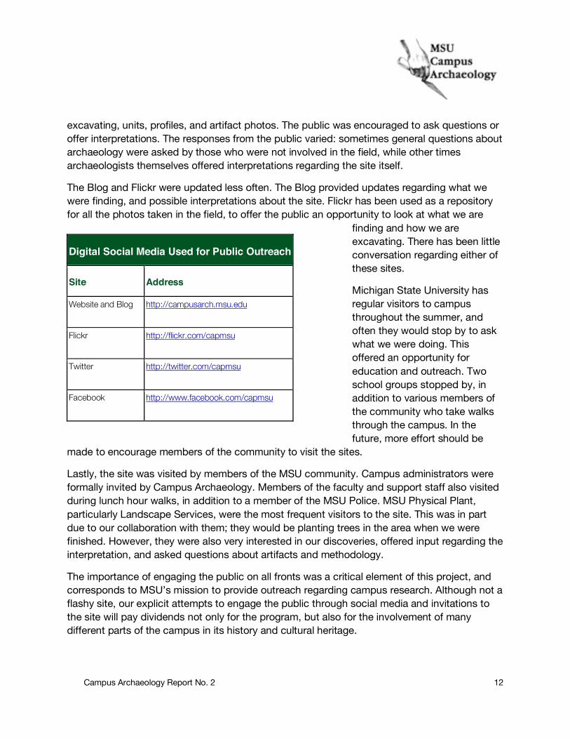
Campus Archaeology has utilized three elements of digital media and social networking sites: Twitter, Flickr, and Facebook, in addition to the Campus Archaeology Program WordPress blog. All four of these were used during excavations at Beal Street. Twitter and Facebook were used in the field, as a means of integrating the public with the work as it happened. Twitter and Facebook were regularly updated by the field director with photos of archaeologists
Figure 9: College Hall after part of it collapsed, August 1918 (Photo courtesy of MSU Archives and Historical Collections).
Campus Archaeology Report No. 2 12
excavating, units, profiles, and artifact photos. The public was encouraged to ask questions or offer interpretations. The responses from the public varied: sometimes general questions about archaeology were asked by those who were not involved in the field, while other times archaeologists themselves offered interpretations regarding the site itself.
The Blog and Flickr were updated less often. The Blog provided updates regarding what we were finding, and possible interpretations about the site. Flickr has been used as a repository for all the photos taken in the field, to offer the public an opportunity to look at what we are
finding and how we are excavating. There has been little conversation regarding either of these sites.
Michigan State University has regular visitors to campus throughout the summer, and often they would stop by to ask what we were doing. This offered an opportunity for education and outreach. Two school groups stopped by, in addition to various members of the community who take walks through the campus. In the future, more effort should be
made to encourage members of the community to visit the sites.
Lastly, the site was visited by members of the MSU community. Campus administrators were formally invited by Campus Archaeology. Members of the faculty and support staff also visited during lunch hour walks, in addition to a member of the MSU Police. MSU Physical Plant, particularly Landscape Services, were the most frequent visitors to the site. This was in part due to our collaboration with them; they would be planting trees in the area when we were finished. However, they were also very interested in our discoveries, offered input regarding the interpretation, and asked questions about artifacts and methodology.
The importance of engaging the public on all fronts was a critical element of this project, and corresponds to MSU’s mission to provide outreach regarding campus research. Although not a flashy site, our explicit attempts to engage the public through social media and invitations to the site will pay dividends not only for the program, but also for the involvement of many different parts of the campus in its history and cultural heritage.
Digital Social Media Used for Public Outreach
Site Address
Website and Blog http://campusarch.msu.edu
Flickr http://flickr.com/capmsu
Twitter http://twitter.com/capmsu
Facebook http://www.facebook.com/capmsu

Campus Archaeology Report No. 2 13
References Cited Beal, William J. 1915 History of the Michigan Agricultural College and Biographical Sketches of Trustees and Professors. Agricultural College, East Lansing, Michigan. Goldstein, Lynne, Terry Peterkin Brock, Chris Stawski, and Elizabeth Pruitt 2010 Faculty Row: Developing a Model for Change at Michigan State University. Manuscript. East Lansing, Michigan. Jacobs, Megan S., and Michael J. Thelen 2008 Geotechnical Evaluation Report: Michigan State University Brody Hall Renovations, East Lansing, Michigan. Soil and Materials Engineers, Inc., Lansing, Michigan, June 20, 2008. Lewandowski, David 2010 College Hall Site Report. Michigan State University, Campus Archaeology Program, Re-port No. 3, East Lansing, Michigan. Mustonen, Heather L. 2007 Public Archaeology and Community Engagement at Michigan State University: The Saints' Rest Archaeological Project. Michigan State University. Dept. of Anthropology. Stanford, Linda O., and C. Kurt Dewhurst 2002 MSU Campus: Buildings, Places, Spaces. Michigan State University Press, East Lansing, Michigan. Swartz, Paul 2009 Personal Communication. June 5. Tooman, Daniel 2010 Brody Complex Site Report. Michigan State University, Campus Archaeology Program, Report No. 2, East Lansing, Michigan. Widdler, Keith R. 2005 Michigan Agricultural College: The Evolution of a Land Grant Philosophy, 1855-1925. Michigan State University Press. East Lansing, Michigan.