2. Approach to EIA and project design - E.ON UK/media/PDFs/Generation/wind/...Approach to EIA and...
40
11 l:\data\projects\ea-210\24421 winwick wind farm (sub file)\24421 winwick es final_em.doc © Entec UK Limited 2. Approach to EIA and project design 2.1 EIA process Overview of EIA 2.1.1 EIA should be a systematic process that must be followed for certain types of project before a decision can be made on development consent. The publication Environmental Impact Assessment: Guide to Procedures (ODPM, 2000) describes EIA as “the whole process whereby information about the environmental effects of the project is collected, assessed and taken into account in reaching a decision on whether the project should go ahead or not”. 2.1.2 The flowchart in Table 2.1 outlines the EIA process as applied to the proposed Winwick Wind Farm. 2.1.3 The ES that is prepared and submitted on behalf of a project developer (EC&R), in conjunction with a planning application, provides details of the development and an assessment of the likely significant environmental effects predicted to arise as a result of it. The ES forms a basis for consultation and enables decision-makers to consider the significant environmental effects when determining the planning application. 2.1.4 In this case the planning application will be determined by Daventry District Council as the Local Planning Authority for the area within which the proposed Winwick Wind Farm is situated. 2.1.5 The assessment of significant environmental effects presented in an ES has a number of key characteristics: • It should be systematic, comprising a sequence of tasks defined both by regulation and by practice; • It should be analytical, requiring the application of specialist skills from the environmental sciences; • It should be impartial, its objective being to inform the decision-maker rather than to promote the development; • It should be consultative, with provision being made for obtaining information and feedback from interested parties including the Local Planning Authority, statutory and non-statutory consultees and the local community; and • It should be iterative, allowing opportunities for environmental concerns to be addressed during the planning and design of a development. 2.1.6 This final point is particularly important with respect to the design of the proposed Winwick Wind Farm. A number of design iterations (in effect, in-built mitigation) have taken place in response to environmental issues identified during the EIA process and
Transcript of 2. Approach to EIA and project design - E.ON UK/media/PDFs/Generation/wind/...Approach to EIA and...
11
l:\data\projects\ea-210\24421 winwick wind farm (sub file)\24421 winwick es final_em.doc © Entec UK Limited
2. Approach to EIA and project design
2.1 EIA process
Overview of EIA 2.1.1 EIA should be a systematic process that must be followed for certain types of project
before a decision can be made on development consent. The publication Environmental Impact Assessment: Guide to Procedures (ODPM, 2000) describes EIA as “the whole process whereby information about the environmental effects of the project is collected, assessed and taken into account in reaching a decision on whether the project should go ahead or not”.
2.1.2 The flowchart in Table 2.1 outlines the EIA process as applied to the proposed Winwick Wind Farm.
2.1.3 The ES that is prepared and submitted on behalf of a project developer (EC&R), in conjunction with a planning application, provides details of the development and an assessment of the likely significant environmental effects predicted to arise as a result of it. The ES forms a basis for consultation and enables decision-makers to consider the significant environmental effects when determining the planning application.
2.1.4 In this case the planning application will be determined by Daventry District Council as the Local Planning Authority for the area within which the proposed Winwick Wind Farm is situated.
2.1.5 The assessment of significant environmental effects presented in an ES has a number of key characteristics:
• It should be systematic, comprising a sequence of tasks defined both by regulation and by practice;
• It should be analytical, requiring the application of specialist skills from the environmental sciences;
• It should be impartial, its objective being to inform the decision-maker rather than to promote the development;
• It should be consultative, with provision being made for obtaining information and feedback from interested parties including the Local Planning Authority, statutory and non-statutory consultees and the local community; and
• It should be iterative, allowing opportunities for environmental concerns to be addressed during the planning and design of a development.
2.1.6 This final point is particularly important with respect to the design of the proposed Winwick Wind Farm. A number of design iterations (in effect, in-built mitigation) have taken place in response to environmental issues identified during the EIA process and

12
l:\data\projects\ea-210\24421 winwick wind farm (sub file)\24421 winwick es final_em.doc © Entec UK Limited
comments received during consultation with statutory and non-statutory consultees and the local community (Section 2.3).
Table 2.1 Winwick Wind Farm EIA process
EIA Regulations
Need for EIA 2.1.7 Schedule 1 of the EIA Regulations lists those developments for which an EIA is a
mandatory requirement. Schedule 2 of the EIA Regulations describes developments for which the need for an EIA is determined by the Local Planning Authority on a case-by-

13
l:\data\projects\ea-210\24421 winwick wind farm (sub file)\24421 winwick es final_em.doc © Entec UK Limited
case basis using the criteria described in Schedule 3 to determine if a particular development requires an EIA.
2.1.8 Wind energy developments that involve the installation of more than two turbines or where the hub height of any turbine or other structure exceeds 15m are a Schedule 2 development. As such, unless an ES is submitted voluntarily (in which case the planning application will be treated as one that is subject to EIA), the Local Planning Authority must screen the development to determine whether an EIA is required. For all Schedule 2 developments where it is decided that it is likely to have significant effects on the environment, either positive or negative, on account of factors such as its nature, scale or location, an EIA is required.
2.1.9 The criteria used for determining whether a Schedule 2 development is likely to have significant effects on the environment are not clearly defined and each proposal must therefore be assessed on its merits against various guidelines. For wind energy developments guidance states that an EIA is more likely to be required for commercial developments of five or more turbines or more than 5MW of new generating capacity.
2.1.10 Given the size of the proposed Winwick Wind Farm and the sensitivity of the surrounding environment, for example, the Daventry Special Landscape Area, EC&R recognised that an EIA would be needed. EC&R also recognised that the EIA process can play an important role in developing the wind farm design to minimise any adverse environmental impacts and capitalise on any positive environmental effects of the development.
2.1.11 It should be noted that, where it has been determined that there is the potential for significant environmental effects to arise and that an EIA is therefore required, it does not necessarily mean that the development will have a significant effect on the environment.
2.1.12 The EIA process requires the potential for significant environmental effects to be identified but then allows a developer to incorporate environmental measures into either the wind farm design, or the methods of construction and operation, to reduce or eliminate any potentially significant adverse environmental effects. It is the significance of any residual effects following the incorporation of environmental measures on which the determination decision is based.
Issues to be addressed 2.1.13 Schedule 4 of the EIA Regulations specifies the information that must or may be
provided in the ES. This includes “A description of the likely significant effects of the development on the environment, which should cover the direct effects and any indirect, secondary, cumulative, short, medium and long-term, permanent and temporary, positive and negative effects of the development…”
2.1.14 Schedule 4 also specifies that the ES should describe those “aspects of the environment likely to be significantly affected by the development, including, in particular population, fauna, flora, soil, water, air, climatic factors, material assets, including the architectural and archaeological heritage, landscape and the inter relationship between the above factors.”

14
l:\data\projects\ea-210\24421 winwick wind farm (sub file)\24421 winwick es final_em.doc © Entec UK Limited
2.1.15 The developer of an EIA project may ask the Local Planning Authority for their formal opinion (a scoping opinion) on the information to be provided in the ES (Section 2.2).
EIA guidance 2.1.16 A range of reference material and guidance has been drawn upon in developing the EIA
methodology adopted for this development. Principal sources over and above the Town and Country Planning (Environmental Impact Assessment) (England and Wales) Regulations 1999 (S.I. 1999 No. 293) include:
• DETR Circular 02/99 Environmental Impact Assessment (DETR, 1999);
• Environmental Impact Assessment: Guide to Procedures (ODPM, 2000);
• Preparation of Environmental Statements for Planning Projects that require Environmental Assessment: Good Practice Guide (HMSO, 1995); and
• Guidelines for Environmental Impact Assessment (IEMA, 2004).
EIA terminology
Defining significance 2.1.17 The EIA Regulations recognise that development proposals affect different
environmental elements to differing degrees and that not all of these are of sufficient concern to warrant detailed investigation or assessment through the EIA process. The EIA Regulations identify those environmental resources that warrant investigation as those that are “likely to be significantly affected by the development”.
2.1.18 The EIA Regulations themselves do not define significance and it is therefore necessary to state how this will be defined for this development. In general qualitative terms this ES has been completed on the basis that, for an effect to be significant, it must be of sufficient scale to:
• Lead to an exceedance of defined guidelines or widely recognised levels of acceptable change; or
• Threaten or enhance the viability or integrity of a receptor or receptor group of concern.
2.1.19 The conclusion about significance is arrived at using professional judgement, with reference to the development description, and available information about potential changes that are expected to be caused by the proposed Winwick Wind Farm and the receptors that may be affected. Professional judgement (in combination with any published guidance) is used to assess the interaction of, a receptor’s sensitivity to change, and the magnitude of change caused by the development, to identify a level of effect. In some cases professional judgement can be guided by quantitative values whilst in other cases qualitative descriptions are used.
2.1.20 Table 2.2 provides an indication of how the level of effect is categorised from the interaction of a receptor’s sensitivity to change and the magnitude of change. Of course, the divisions between categories of receptor sensitivity and magnitude of change

15
l:\data\projects\ea-210\24421 winwick wind farm (sub file)\24421 winwick es final_em.doc © Entec UK Limited
may not be as clearly delineated as shown and professional judgement is always applied.
2.1.21 For some of the topics that are assessed in the ES there is published guidance about significance evaluation. Where such topic-specific guidance exists (even if in draft) it has been used to inform the development of the significance evaluation methodologies used in this ES. For other topics, it has been necessary to develop methodologies without the benefit of guidance. This has involved technical specialists drawing on their previous experience of evaluating the significance of environmental effects to determine whether effects are significant or not.
2.1.22 In general environmental effects are categorised as – no effect, not significant or significant. In the example shown in Table 2.2 those environmental effects which are shaded equate to those considered significant under the EIA Regulations with the others constituting no effect or an insignificant effect.
Table 2.2 Establishing the level of effects
Magnitude of change Receptor sensitivity
Negligible Low Medium High
National No Effect Not Significant Significant Significant
Regional No Effect Not Significant Significant Significant
County No Effect Not Significant Not Significant Significant
Local No Effect Not Significant Not Significant Not Significant
Note:- levels of effect shown in shaded boxes are considered significant in terms of the EIA Regulations
Impacts and effects 2.1.23 EIA is concerned with the identification of likely significant environmental effects.
However the terms impact and effect are often used synonymously and this can lead to confusion. For clarity in this assessment a cause and effect logic is applied where impacts are the change that arises (e.g. change in drainage pattern) and effects are the consequences of that change (e.g. habitat becomes degraded by change in drainage). They have been defined as follows:
• Impact: any change attributable to the development that are likely to result in an environmental effect, i.e. they are the cause of the environmental effect; and
• Effect: the result of the change in relation to specific environmental resources or receptors (an effect may in turn produce further change, i.e. an effect may become an impact in its own right.)
Types of effect 2.1.24 The EIA Regulations require consideration of effects whether: direct / indirect /
secondary / cumulative / positive / negative / short / medium / long-term / permanent or temporary. Key here however is not the type of effect, but that all the effects arising from the development are considered in the assessment.

16
l:\data\projects\ea-210\24421 winwick wind farm (sub file)\24421 winwick es final_em.doc © Entec UK Limited
2.1.25 All effects are considered in terms of their valency - positive (representing environmental gain) or negative. There may also be cases where it is appropriate to identify that a change may occur but to note that the change is either neutral – and neither specifically beneficial nor adverse or is a matter of personal opinion.
2.1.26 All effects are also considered in terms of their duration. Effects can typically be:
• Temporary – these are likely to last for a period of a few days to a few months, they will be related to a particular activity and will cease as soon as the activity ceases;
• Short-term – this would normally be considered to be between a period of a few months to a few years depending on the topic and effect being discussed and the environment’s ability to recover from an impact;
• Long-term – this would typically be a period of between a few years and the life of the development; and
• Permanent – this would typically mean an irreversible change in the environment.
2.1.27 In terms of how effects arise the following are considered:
• Direct effects are readily identified because of the physical connection between some element of the development and an affected receptor;
• Indirect effects require some additional pathway for the effect to arise, for example, a listed building may not be directly impacted by any elements of a development, but if the development changed its wider setting there would be an indirect effect;
• Secondary effects would typically require further pathway connections, for example, an effect on a receptor population A could have a secondary effect on receptor B if B was itself dependent on A in some way, as for example, a food source; and
• Cumulative effects arise when the receptors affected by one development are also affected by a second development (which may be of differing form) resulting in the aggregation of effects or the interaction of impacts.
Temporal and spatial scope 2.1.28 The temporal scope of the EIA covers the period from commencement of the first phase
of development (construction) through to the operational phase (operation) up to completion of operations and restoration of the development site (decommissioning).
2.1.29 In its broadest sense, the spatial scope of an EIA is the area over which changes to the environment would occur as a consequence of the development. In practice, the EIA focuses on those areas where these changes may result in significant environmental effects.
2.1.30 The spatial scope varies between the environmental topics assessed. For example, the effect of the proposed Winwick Wind Farm upon the landscape resource and visual amenity is assessed within a zone of up to 30km from the development site boundary of the wind farm, whilst ecology related effects are normally assessed within a much smaller area encompassing a zone of up to 4km from the developable area.

17
l:\data\projects\ea-210\24421 winwick wind farm (sub file)\24421 winwick es final_em.doc © Entec UK Limited
EIA methodology 2.1.31 Following the identification of the scope of the EIA, individual technical topic
investigations and assessments are progressed using appropriate methodologies. These methodologies are based on recognised good practice and guidelines specific to each subject area, details of which are provided within each individual technical chapter.
2.1.32 In general terms the technical topic studies would include:
• Ongoing consultation in response to emerging study findings;
• Collection and collation of baseline information about the receptors and effects considered within the scope along with prediction using professional judgement and trend data of how the baseline may evolve or be evolving;
• Consideration of the potential effects of the development on the predicted baseline along with the identification of any appropriate scheme changes from a topic specific basis to seek to avoid or reduce predicted adverse effects;
• Engagement with other technical topic specialists in a design iteration process seeking to optimise the scheme layout for the differing environmental effects; and
• Assessment of the effects of the final scheme and evaluation of the significance of any residual effects followed by reporting in the ES.
2.1.33 In general, for each environmental topic, the following format has been adopted with regard to the presentation of information in this ES:
• Summary;
• Introduction – provides an overview of the chapter and its contents;
• Policy and Legislative Context – summarises the planning policy issues relevant to that environmental topic;
• Data Gathering Methodology – describing the methods adopted in determining the baseline situation;
• Overall Baseline – describing the current baseline situation, predicted trends in the absence of the proposed development and highlighting any information gaps;
• Environmental Measures Incorporated into the Scheme – description of potentially significant effects and how the design has evolved to minimise impacts that could potentially occur;
• Scope of the Assessment – details the potential receptors that could be affected by the proposed development, potentially significant environmental effects that have been reduced or eliminated by the incorporation of environmental measures into the scheme, and the potentially significant residual effects that have been subject to further assessment;
• Assessment Methodology – describing the methods adopted in carrying out the assessment;

18
l:\data\projects\ea-210\24421 winwick wind farm (sub file)\24421 winwick es final_em.doc © Entec UK Limited
• Assessment of Effects – details the effects predicted to occur (allowing for the assumed environmental measures) as a result of the proposed development and an assessment of the nature and magnitude of these effects;
• Conclusions of Significance Evaluation – conclusion as to the significance of any residual effects identified; and
• References.
2.1.34 For ease of reporting the temporal scope is considered in relation to the following key stages of the development:
• Construction – effects may arise from the construction activities themselves or from the temporary occupation of land. The effects are often temporary and of limited duration although there is the potential for permanent effects as well. It is also the case that construction activities create permanent change, i.e. the effects arising from these changes occur over the operational period;
• Operation – effects are typically permanent (subject to any future decommissioning) though may also be related to operational emissions or effects that will stop if the operation stops; and
• Decommissioning – effects may arise from the decommissioning activities themselves or from the temporary occupation of land. The effects would often be temporary and of limited duration and additional permanent change (unless associated with restoration) would normally be unlikely.
2.1.35 Careful attention is paid to avoid the potential for overlap between technical topic chapters. So, for example, all visual amenity effects including on those visiting cultural heritage features would be addressed within the Landscape and Visual chapter whilst the Cultural Heritage chapter retains a focus on direct effects on cultural heritage resources (whether sub-surface remains or visible structures) and on any potential effects on the intrinsic setting of cultural heritage features. Similarly any effects on ecological resources arising from hydrological change would be considered in the Ecology chapter with the change in hydrological characteristics considered in the Geology, Hydrology and Hydrogeology chapter.
2.2 Scoping process
Scoping process 2.2.1 Scoping is the process of identifying those aspects of the environment and the issues
that need to be considered in assessing the significant environmental effects of a proposed development. This recognises that there may be some elements of the environment on which the development will have no significant effects and hence where there is no need for further investigation to be undertaken.
2.2.2 Scoping is undertaken through consultation with the Local Planning Authority and statutory and non-statutory consultees with an interest in and knowledge of the development site combined with the professional judgement of the EIA team. It takes
19
l:\data\projects\ea-210\24421 winwick wind farm (sub file)\24421 winwick es final_em.doc © Entec UK Limited
account of published guidance, the effects of the kind of development under consideration and the environmental resources that could be affected.
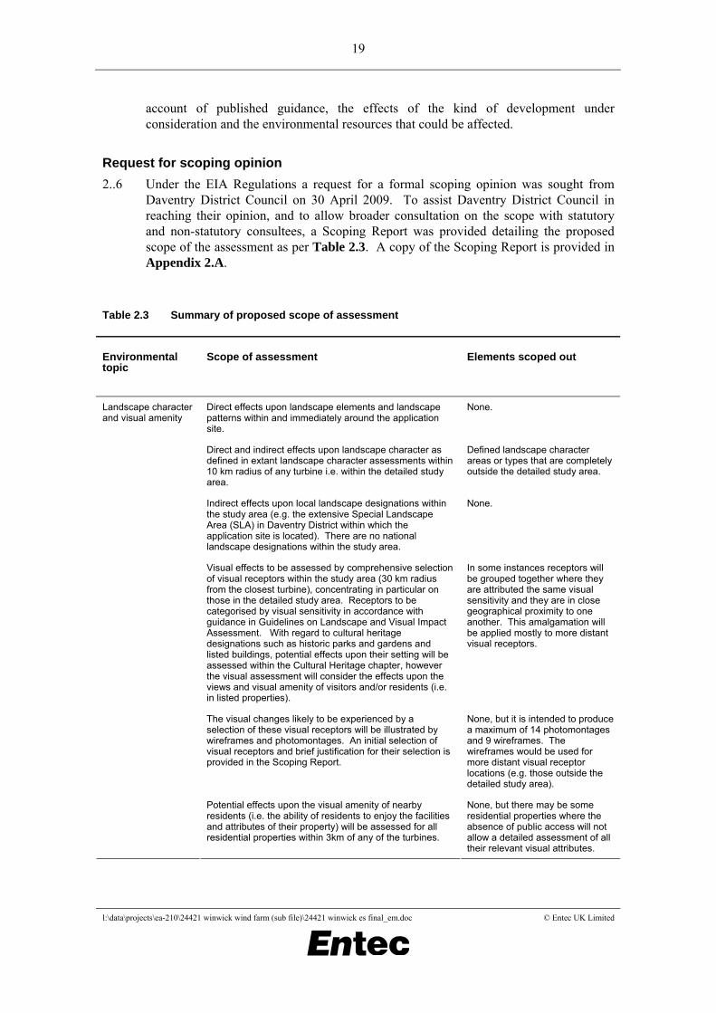
Request for scoping opinion 2..6 Under the EIA Regulations a request for a formal scoping opinion was sought from
Daventry District Council on 30 April 2009. To assist Daventry District Council in reaching their opinion, and to allow broader consultation on the scope with statutory and non-statutory consultees, a Scoping Report was provided detailing the proposed scope of the assessment as per Table 2.3. A copy of the Scoping Report is provided in Appendix 2.A.
Table 2.3 Summary of proposed scope of assessment
Environmental topic
Scope of assessment Elements scoped out
Direct effects upon landscape elements and landscape patterns within and immediately around the application site.
None.
Direct and indirect effects upon landscape character as defined in extant landscape character assessments within 10 km radius of any turbine i.e. within the detailed study area.
Defined landscape character areas or types that are completely outside the detailed study area.
Indirect effects upon local landscape designations within the study area (e.g. the extensive Special Landscape Area (SLA) in Daventry District within which the application site is located). There are no national landscape designations within the study area.
None.
Visual effects to be assessed by comprehensive selection of visual receptors within the study area (30 km radius from the closest turbine), concentrating in particular on those in the detailed study area. Receptors to be categorised by visual sensitivity in accordance with guidance in Guidelines on Landscape and Visual Impact Assessment. With regard to cultural heritage designations such as historic parks and gardens and listed buildings, potential effects upon their setting will be assessed within the Cultural Heritage chapter, however the visual assessment will consider the effects upon the views and visual amenity of visitors and/or residents (i.e. in listed properties).
In some instances receptors will be grouped together where they are attributed the same visual sensitivity and they are in close geographical proximity to one another. This amalgamation will be applied mostly to more distant visual receptors.
The visual changes likely to be experienced by a selection of these visual receptors will be illustrated by wireframes and photomontages. An initial selection of visual receptors and brief justification for their selection is provided in the Scoping Report.
None, but it is intended to produce a maximum of 14 photomontages and 9 wireframes. The wireframes would be used for more distant visual receptor locations (e.g. those outside the detailed study area).
Landscape character and visual amenity
Potential effects upon the visual amenity of nearby residents (i.e. the ability of residents to enjoy the facilities and attributes of their property) will be assessed for all residential properties within 3km of any of the turbines.
None, but there may be some residential properties where the absence of public access will not allow a detailed assessment of all their relevant visual attributes.

20
l:\data\projects\ea-210\24421 winwick wind farm (sub file)\24421 winwick es final_em.doc © Entec UK Limited
Environmental topic
Scope of assessment Elements scoped out
Assessment of potential cumulative visual effects that could be generated by the interaction of the proposed Winwick Warren Wind Farm and other existing, consented and proposed (i.e. a planning application has been submitted) wind farms within 60km of the application site. This distance is selected to be in accordance with Scottish Natural Heritage (SNH) guidance which is widely accepted as being the template applied to cumulative assessment of wind farm proposals throughout the UK.
Any proposals, which whilst in the public domain, have not yet formally submitted a planning application and accompanying ES, on the basis that there is insufficient certainty that such proposals will ever become operational.
An initial appraisal has identified the remains of medieval ridge and furrow cultivation within the site. Otherwise no specific archaeological potential has been identified, although prehistoric remains are recorded to the north of the site.
It will be important to further establish the archaeological potential of land within the site. To this end the ES will include a desk-based assessment of official registers, primary and secondary records, including those held in Northamptonshire Sites and Monuments Record (SMR) and County Record Office, and the National Monuments Record. This will inform design iteration and any evaluative work which may be needed prior to construction of the wind farm.
A site visit and walkover will also be undertaken. Mitigation is likely to include the siting of turbines in order to avoid known features and areas of potential, along with measures incorporated into the scheme to record any previously unidentified features.
Aerial photography of the area appears to have been comprehensively studied as part of the National Mapping Programme and other county-based studies. It is not intended to replicate this work during the assessment and it is not expected that aerial photographs held as part of the SMR or those at Cambridge University Library will need to be consulted. However, a check will be made for any available photographs not included in studies undertaken.
Archaeology and cultural heritage
A number of designated cultural heritage features, including a scheduled monument and numerous listed buildings, lie in the vicinity of the site. Naseby Battlefield lies some 3.2km to the north east of the site and the registered park and garden of Cottesbrooke Hall lies some 4.5km to the east of the site. An assessment will be made of the potential for the scheme to affect the settings of these cultural heritage features. A brief account of the assessment of effects on designated cultural heritage features within a 5km radius of turbines will be presented in the ES.
This assessment will be made in close cooperation with the landscape character and visual amenity assessment and will include wireframe and photomontage viewpoints from key cultural heritage receptors as required. Key cultural heritage receptors identified for further detailed assessment during the EIA are given in the attached document.
Initial appraisal of likely receptors has concluded that no cultural heritage receptors more than 5km from turbines will be significantly affected.

21
l:\data\projects\ea-210\24421 winwick wind farm (sub file)\24421 winwick es final_em.doc © Entec UK Limited
Environmental topic
Scope of assessment Elements scoped out
Geology, hydrology and hydrogeology
Desk based assessment, consulting available published information from Ordnance Survey mapping, British Geological Society, the Environment Agency, water suppliers and Daventry District Council. The desk based assessment will be supplemented by a site visit to develop a conceptual understanding of river flow, drainage connectivity and water quality.
The desk based assessment will enable the importance of hydrological receptors to be identified and this will be taken into account in determining the impacts on water quality and quantity.
A separate Private Water Supply Risk Assessment may be required if small local supplies are identified close to the site.
Impacts on geology and land contamination are scoped out. Geological information will be used to put into context the hydrological environment.
Flood Risk Assessment is scoped out as the site lies within the lowest flood risk zone, Flood Zone 1. However, consideration will be given to surface water drainage to prevent flood risk increasing downstream of the development.
Terrestrial and aquatic ecology
Impact on habitats and protected species present within the application site boundary, supported by:
Extended Phase 1 habitat survey (already completed).
Great crested newt surveys of ponds within the application site boundary and, where access is possible, within 500m of the site boundary.
Badger survey of suitable habitat on site as identified during the Phase 1 survey.
Water vole surveys along the wet ditches and small stream on site within 50m of working areas.
Bat activity surveys along pre-determined transects across the site taking in key features of potential value to bats. Survey effort to follow Natural England guidelines.
Assessment of trees (not buildings) on site for bat roost potential followed, if appropriate, by bat emergence surveys.
No additional surveys for other protected species are considered necessary (e.g. otter, reptiles) given the habitats on site and the nature of the works.
No additional vegetation surveys are considered necessary.
Ornithology Vantage Point Surveys covering a full 12 months to identify use of the air space by target bird species.
Winter field counts to establish the numbers of waders and other species using the arable and pasture land for foraging etc (already undertaken).
Common bird census (using a three visit strategy) to determine the make-up of the breeding bird community.
None.
Socio-economics and public attitudes
Desk based assessment to determine: benefits in relation to the alleviation of climate change; generation of employment opportunities; and direct/indirect effects on economic activity.
None. Effects on local residents and the local community due to visual impact, shadow flicker and noise will be dealt with in detail within other technical assessments.
Public access, safety and shadow flicker
Desk based assessment to include effects on recreational access with particular reference to Public Rights of Way and their use by walkers and horse riders in accordance with Planning Policy Statement 22: Renewable Energy (PPS22).
Shadow flicker assessment for properties situated within ten times turbine rotor diameter.
In accordance with the Companion Guide to PPS22, properties greater than ten rotor diameters from a turbine will not require a shadow flicker assessment.

22
l:\data\projects\ea-210\24421 winwick wind farm (sub file)\24421 winwick es final_em.doc © Entec UK Limited
Environmental topic
Scope of assessment Elements scoped out
Transport Desk based assessment to determine transportation impacts associated with the movements of Heavy Goods Vehicles travelling to and from the site during construction.
Consideration will be given to the following potential effects on the identified receptors (access route): severance; driver delay; pedestrian delay; pedestrian amenity; fear and intimidation; and accidents and safety.
Once the wind farm is operational, it is envisaged that the amount of traffic associated with the scheme would be minimal. It is considered that the effects of operational traffic would be negligible and therefore further consideration does not need to be given to operational traffic.
Noise Operational noise effects to be considered. Background noise levels proposed to be recorded in accordance with ETSU guidelines. Number and locations for monitoring to be agreed with Environmental Health Officer when scheme design progressed. Noise limits to protect amenity to be established as recommended in PPS22.
Construction noise will be evaluated but is expected to be controlled through adoption of good practice guidelines and standard mitigation.
Traffic noise during construction will be evaluated once access route and scale of movements known.
Operational traffic noise likely to be minimal as traffic movements very low, propose to scope out.
Infrastructure, telecommunications, utilities, and air safeguarding issues
Desk based assessment to include potential for interference with radar and electromagnetic signals determined in consultation with operators.
None.
Dust and Air Quality Not applicable. Dust can be controlled through the adoption of environmental best practice during construction and has therefore been scoped out of the assessment.
Emissions from construction and operation traffic are considered to be negligible.
Scoping opinion 2..7 Daventry District Council issued their Scoping Opinion on 05 August 2009. The
scoping opinion raised the following issues in relation to the following environmental topics for consideration:
• Planning context – the East Midlands Regional Plan (adopted March 2009) has replaced the Regional Spatial Strategy for the East Midlands (March 2005) and consequently the Northamptonshire Structure Plan has been replaced with the exception of Policy SD1 only. In addition to saved policies GN1 (General), GN2 (General) and Policy ENV1, there are other saved policies within the Daventry District Local Plan that may also be of relevance;
• Landscape character and visual amenity – the ES should demonstrate the suitability of the site taking into account other possible alternatives. It was advised that the proposed list of viewpoints is expanded to take account of scoping consultation comments received; including views from surrounding roads and PRoW, and that consideration is given to viewpoints from Cultural Heritage assets;

23
l:\data\projects\ea-210\24421 winwick wind farm (sub file)\24421 winwick es final_em.doc © Entec UK Limited
• Archaeology and cultural heritage – the advice set out in PPG16 should be taken into account and the impact on any Registered Parks and Gardens, Conservation Areas and listed buildings considered. English Heritage should be fully engaged and any recommendations taken into account;
• Hydrology and hydrogeology – early dialogue with the Environment Agency is required;
• Terrestrial and aquatic ecology and ornithology – ecological surveys should be undertaken at the right time of year and over a sufficient period of time. The relevant organisations (Natural England, RSPB, Northants Wildlife Trust, Northants Bat Group and Northants Badger Group) should be contacted to agree assessment methodologies. Opportunities for biodiversity enhancements should be considered;
• Socio-economics and public attitude –a statement of community involvement should be submitted as part of the application, demonstrating the extent to which local communities were engaged prior to submission of the application;
• Public access, safety and shadow flicker – consultation should be undertaken with the Council for Protection of Rural England (CPRE). Issues such as ice being thrown from blades, potential for structural failure and health concerns have been raised and these issues should be addressed in the ES;
• Transport – given the locations of the site near to the A14(T) and other roads the Highways Agency, the relevant county highways authorities and any other relevant bodies should be consulted and their views taken into account;
• Noise – agreement should be reached with the Council’s Environmental Health Officer on the proposed approach prior to preparation and submission of the ES;
• Infrastructure, telecommunications, utilities and air safeguarding issues – the relevant bodies and organisations should be contacted at an early stage to identify potential issues and agree any necessary mitigation; and
• Other issues – the ES should detail the grading of the agricultural land affected by the development, how much will be lost as a result of the development, and how agricultural use of the land would continue.
2..8 The scoping opinion is present in full in Appendix 2.B with Table 2.4 providing a summary of the main points raised by consultees responding to Daventry District Council.

24
l:\data\projects\ea-210\24421 winwick wind farm (sub file)\24421 winwick es final_em.doc © Entec UK Limited
Table 2.4 Summary of consultations received in response to Scoping Report
Consultee Date of response
Issue raised Response
National Air Traffic Services
18/05/2009 Unable to comment on the proposals at this stage. Provided details of their pre-planning consultancy service offered.
Further consultation was undertaken with National Air Traffic Services as part of the Telecommunications, Infrastructure, Utilities and Aviation assessment following the development of an indicative site layout for the proposed Winwick Wind Farm (refer to Chapter 14). However, they only provide a consultancy service at the pre-planning application stage.
Northants Bat Group
21/05/2009 The Northants Bat Group hold a large database of bat records, and should be the body approached for past bat records.
The walked transect routes proposed are those designed for surveying at ground level and useful for ground-based developments such as housing, roads and similar. They were not designed to assess dangers such as turbine blades high up, nor are they entirely suitable for this. The Eurobats guidelines No 3 for surveying potential wind turbine sites, and the recent Natural England guidance should be incorporated.
Records were obtained from the Northants Bat Group of bat species recorded within 10km of the development site.
The combination of desk search, roost surveys and activity surveys undertaken over April – October 2009 provided details of the bat species using the site in order to inform the ecological assessment. It was identified that pipistrelle, noctule and myotis bats are present.
Recent research has found that on open sites “no extra species groups were recorded at height [30m] than were recorded at ground level“ and that “total bat passes … were significantly higher on the lower detectors compared with the upper detectors.”10 Significantly they found that the “difference between numbers of passes of Nyctalus/Eptesicus at the upper and lower detectors was not significant.”
Given that high flying noctule species were recorded at ground level, the lack of surveys at height does not compromise the validity of the ecological assessment.
10 Jan Collins, University of Bristol and RSK Carter Ecology (2009) Differences in bat activity in relation to bat detector height: implications for bat surveys at proposed windfarm sites, Acta Chiropterologica, Volume 11, Number 2, December 2009 , pp. 343-350(8)

25
l:\data\projects\ea-210\24421 winwick wind farm (sub file)\24421 winwick es final_em.doc © Entec UK Limited
Consultee Date of response
Issue raised Response
Northamptonshire County Archaeological Advisor
22/05/2009 As the Sites and Monuments Record contains only presently identified archaeological resources, the submission of a desk based assessment would not provide sufficient information on the archaeological potential of the development area and would not provide a definitive answer as to the possibility of the presence of hitherto unidentified archaeological deposits. Non intrusive and intrusive archaeological evaluation of the proposed turbine bases and crane beds should be undertaken in order to assess the archaeological potential of the development area.
The baseline overview has identified that the study area has a number of areas of ridge and furrow, which were identified within the Open Fields Project. It is expected that the desk based assessment would include the present state of the existing ridge and furrow as identified during the site visit and walkover. This would be of value as ideally the development should impact as little as possible on any areas of good quality ridge and furrow survival. There is also the potential for prehistoric activity within the landscape which may be masked by the ridge and furrow.
The desk-based assessment has been undertaken, to include documentary research of a full range of sources, including historic maps and aerial photographs, in addition to the Sites and Monuments Record.
Most areas of ridge and furrow identified in 1995 (Open Fields Project) have subsequently been ploughed-out. Remaining areas lie outside the footprint of the proposed scheme.
In light of the comments from the Archaeological Advisor, both non-intrusive (geophysical survey) and intrusive (trial trenching) evaluation have been undertaken. The County Archaeological Advisor monitored the ongoing trial trench evaluation.
While some archaeological features are present (in the areas of turbines 5, 6 and 7) these were not considered to be of sufficient importance to warrant any changes to the scheme design. Refer to Chapter 5 Archaeology and Cultural Heritage for further details of the impact assessment.
English Heritage 22/05/2009 English Heritage has drawn up guidelines for planners and developers, Wind Energy and the Historic Environment. These guidelines are designed to be used alongside other current standard methodologies associated with the development of such proposals.
A number of considerations will need to be taken into account in the assessment, including:
• The potential impact upon the landscape, especially if a site falls within an area of historic landscape;
• Direct impacts on historic/archaeological fabric (buildings, sites or areas), whether statutorily protected or not. All grades of listed buildings should be identified;
• Other impacts, particularly the setting of listed buildings, scheduled monuments, registered parks and gardens, conservation areas etc, including long views and any specific designed views and vistas within historic designed landscapes. In some cases, inter-visibility between historic sites may be a significant issue;
• The potential for buried archaeology;
• Effects on landscape amenity from public and private land; and
• Cumulative impacts.
Refer to Chapter 5 Archaeology and Cultural Heritage and Chapter 6 Landscape and Visual Impact which address the issues raised.
The desk-based assessment has been undertaken, to include documentary research of a full range of sources, including historic maps and aerial photographs, in addition to the Sites and Monuments Record.
Both non-intrusive (geophysical survey) and intrusive (trial trenching) evaluation have been undertaken to assess the potential for buried archaeology.
Key visual receptors that English Heritage recommended for inclusion in the assessment have been fully considered in Chapter 5 Archaeology and Cultural Heritage.
Photomontages have been produced from a range of viewpoints, including Cottesbrooke Hall and Park, and from the minor road bridge over A14(T) near Naseby, which is representative of views available within the Naseby registered battlefield.

26
l:\data\projects\ea-210\24421 winwick wind farm (sub file)\24421 winwick es final_em.doc © Entec UK Limited
Consultee Date of response
Issue raised Response
Zones of Theoretical Visibility of the proposed development should initially be based on topographical data before the impact of existing trees and buildings etc. on lines of sight is assessed. Photomontages should be produced for key viewpoints; English Heritage would wish to be consulted about possible viewpoints where significant historic assets are affected.
List a number of key visual receptors in the area and state that any impact upon them would need to be considered in depth.
The County Historic Environment Record holds information on undesignated archaeology and should also be consulted.
Warwickshire County Council
26/05/2009 Due to the proposed location and the assumed construction traffic routes, Warwickshire County Council has no comments. However, should the construction traffic routes be routed through Warwickshire, then the Council would like to be consulted.
It is not intended to route any access routes through Warwickshire. Refer to Chapter 10 Traffic and Transport for details of the proposed access routes.
Royal Society for the Protection of Birds
26/05/2009 The scope of the Environmental Impact Assessment work in respect of ornithological matters looks satisfactory and the Royal Society for the Protection of Birds are pleased to note that the surveys and risk assessment will follow the Scottish Natural Heritage methodology.
N/A
Daventry District Council Environmental Health Officer
27/05/2009 The Council agree with the assessment of construction site noise methodology proposed in the Scoping Report. Please note the Council permits construction site noise between the hours of 08:00 to 18:00 hours Monday to Friday. 08:30 to 13:00 hours Saturdays and no construction work on Sundays or bank holidays.
The Council agree with the assessment criteria for operational noise as being compliant with ETSU-R-1997.
In relation to the choosing of sites, the Council agree with the locations in principal, however, consideration should be given to a monitoring location at a property on the south western fringe of Cold Ashby as this location is likely to receive greater noise from the proposed wind farm due to the prevailing wind.
Sites should be chosen considering the worst case scenario, and properties which may be more sensitive due to their orientation or layout favoured. The microphone must be located in free field conditions away from solid structures in accordance with ETSU-R-97. Details of why the sites were chosen, including photographs of the set up location, must be included.
The noise assessment has been undertaken in accordance with ETSU-R-97 and the relevant information provided as requested.
As agreed with the Daventry District Council Environmental Health Officer, noise monitoring was undertaken at the Cold Ashby Bowls Club to the south west of Cold Ashby, which is the furthest point to the south west and closest to the proposed Winwick Wind Farm.
Information on the chosen sites is provided in Chapter 11 Noise, Section 11.3 with photographs of the set-up location provided in Appendix 11.A.
For further details refer to Chapter 11 Noise.

27
l:\data\projects\ea-210\24421 winwick wind farm (sub file)\24421 winwick es final_em.doc © Entec UK Limited
Consultee Date of response
Issue raised Response
Monitoring locations must be representative of the worst case scenario for noise sensitive receptors in the area, data from sites that are not representative and/or are adversely affected by other more localised noise sources, or if insufficient descriptive detail is provided the Council will not have sufficient data to make an assessment. All locations must be at least 3.5m from all reflective surfaces and vegetation.
The chosen sites must be detailed with a six figure grid-reference and photographs.
Wind speed and weather data must be presented to show that background monitoring has been undertaken in a suitable range of wind speeds and weather conditions.
Average background noise levels, per wind speed from 2m/s to 12m/s, per assessment location, must be presented in graphical format and with a table for each monitoring location showing the average LA90 levels for each wind speed at each location.
Justification must be given as to why or why not the tonal penalty has been applied in relation to the tonal noise from the whole wind farm and not just the turbines, i.e. tonal noise from electrical equipment at base of towers etc.
The report should include an assessment of audibility of noise from the turbines.
Modelled turbine noise must be undertaken using an “assessment envelope”. This means using all of the turbines that it is suggested may be fitted obtaining their Sound Power Level for each wind speed and modelling the turbines based upon the highest Sound Power Level per wind speed.
If a particular type of turbine is to be assessed. Warranted sound power levels and assessment of tonality must be provided.
Any witnessed adverse noisy events which could have affected the background noise monitoring must be recorded and the measurements adjusted accordingly.

28
l:\data\projects\ea-210\24421 winwick wind farm (sub file)\24421 winwick es final_em.doc © Entec UK Limited
Consultee Date of response
Issue raised Response
Rugby Borough Council
29/05/2009 The Scoping Opinion would appear to refer to all the main areas for consideration. Therefore, the only point to make at this stage is that the impact of reflected light from the wind turbines should also be considered.
Refer to Chapter 13 Public Access, Safety and Shadow Flicker, which includes an assessment of potential shadow flicker from the proposed Winwick Wind Farm, undertaken in accordance with The Companion Guide to Planning Policy Statement 22: Renewable Energy.
Turbines can also cause flashes of reflected light, which can be visible for some distance. Careful choice of blade colour and surface finish can help reduce the effect. In this case the turbines are proposed to be coloured pale gray with a semi-matt finish to reduce their potential contrast with the background sky.
East Midlands Regional Assembly
01/06/2009 Recommend Policy 1 as a basis for scoping. The East Midlands Regional Plan (March 2009) seeks a holistic approach to the development process and therefore the Regional Core Objectives set out in Policy 1 reflect the social, economic, environmental and resource efficiency facets of sustainable development.
Policy 40 contains the Regional Priorities for low carbon energy generation, including matters to give consideration in establishing criteria for onshore wind energy.
Policies 1 and 40 of the Regional Plan have been considered and are referred to in Chapter 4 Renewables and Planning Policy Context, Section 4.5.
Stanford on Avon Parish Council
02/06/2009 There are several areas about which the local residents of the Parish are particularly worried about the proposed wind farm, as follows:
Health - concern about the health risks that the wind farm would pose to the local community.
Noise - the turbines will constantly generate a great deal of noise.
Visual Impact - the turbines are considerably higher than any other construction in the area and will blight the rural landscape.
Hope that the scoping opinion will take into account the above and other environmental issues such as potential flooding caused by changes to the flow of water in the area.
Consideration has been given to health impacts in Chapter 12 Socio-economics and Public Attitude.
Refer to Chapter 11 Noise for further details of the potential noise impact of the proposed Winwick Wind Farm.
Refer to Chapter 6 Landscape and Visual Impact for further details of the potential landscape and visual impact of the proposed Winwick Wind Farm.
Refer to Chapter 7 Hydrology and Hydrogeology for further details of the potential effect of the proposed Winwick Wind Farm upon flood risk.
1 Manor Cottage, Winwick
02/06/2009 Objects to the wind farm as such a project would destroy the visual beauty of the area, especially when viewed from the very popular Jurassic Way.
Consideration has been given to the issues raised. Refer to Chapter 6 Landscape and Visual Impact for further details of the potential landscape and visual impact of the proposed Winwick Wind Farm, including the potential visual impact from the Jurassic Way.

29
l:\data\projects\ea-210\24421 winwick wind farm (sub file)\24421 winwick es final_em.doc © Entec UK Limited
Consultee Date of response
Issue raised Response
Winwick Parish Council
03/06/2009 The Planning Guidance for Winwick is that there should be no development and that the Parish should remain rural.
There was some concern as to noise although again, at this stage, there was insufficient data to object in a concrete manner, albeit that various members of the village through personal experience were able to say that the noise of other wind farms was significantly louder than people had been led to believe prior to their erection.
The turbines would, by virtue of their very height and magnitude, spoil a very attractive visual backdrop to the Village and would adversely affect leisure activities, i.e. walkers on the Jurassic Way and golfers at Cold Ashby Golf Course.
The village understood the macro arguments for alternative energy sources but these should be placed in locations where there was already noise and visual impairment.
Consideration has been given to the issues raised.
Refer to Chapter 11 Noise for further details of the potential noise impact of the proposed Winwick Wind Farm.
Refer to Chapter 6 Landscape and Visual Impact for further details of the potential landscape and visual impact of the proposed Winwick Wind Farm.
West Haddon Parish Council
04/06/2009 The Parish Council have concerns on the cumulative impact due to all the other applications in the area for wind farms, the visual impact on residents and concerns over health effects for which there is no scientific evidence.
Refer to Chapter 6 Landscape and Visual Impact for further details of the potential landscape and visual impact of the proposed Winwick Wind Farm, which includes consideration of cumulative impacts.
Consideration has been given to health impacts in Chapter 12 Socio-economics and Public Attitude.

30
l:\data\projects\ea-210\24421 winwick wind farm (sub file)\24421 winwick es final_em.doc © Entec UK Limited
Consultee Date of response
Issue raised Response
Northamptonshire Wildlife Trust
05/06/2009 The Wildlife Trust would expect to see an analysis of the cumulative effects of the proposal with any other proposed or operational wind farms in the wider area.
As a general over-arching comment, the Trust feel that there are very likely to be specific potential areas of significance and concern related to the possibility of both injury and fatality in respect of bat and bird species associated with this particular application near to Winwick Warren. The Trust therefore strongly recommends that the advice and opinions of all of the relevant statutory and non-statutory consultees is sought.
New developments should both protect and enhance local biodiversity as an integral part of any proposal. Alongside an assessment of the existing ecological value of the site the Trust would like to see the identification of opportunities for enhancement.
Adequate baseline surveys should be completed to assess the value of the site and surrounding area. At least an Extended Phase I Habitat Survey be carried out, and all statutory and non-statutory sites, protected species and other relevant species and habitats be fully investigated and evaluated. In particular, the Trust would recommend that bat surveys ascertain whether bat flights occur across the site, and therefore assess potential strike risks, as well as determining all bat roosts and foraging routes on and around the site.
Furthermore, the Trust recommends that, as part of the investigative work for bats, an element of the surveying exercise is actually carried out at altitude.
Information on sites and wildlife records for the area should be obtained from the Northamptonshire Biodiversity Records Centre and other appropriate county recorders and special interest groups. The proposed wind farm lies in an area that is surrounded by a number of designated Local Wildlife Sites and Potential Wildlife Sites.
An assessment of potential cumulative effects that could be generated by the proposed Winwick Warren Wind Farm and other existing, consented and proposed wind farms has been undertaken. Refer to Chapter 2, Table 2.6 for details of the wind farm developments assessed for cumulative impacts and the individual technical chapters for the cumulative impact assessments.
Consultation has been undertaken with the relevant statutory consultees as recommended. Refer to Chapter 8 Terrestrial and Aquatic Ecology, and Chapter 9 Ornithology for details of consultation undertaken.
An outline habitat improvement plan has been developed, the aim of which is to deliver biodiversity enhancements and enable the development of Green Infrastructure on-site. A copy of the outline habitat improvement plan is provided in Appendix 8.I.
The ecological assessment has been informed by a desk based assessment (including records from the Northamptonshire Biodiversity Records Centre) and a phase one habitat survey followed by surveys for bats, badger, great crested newt, water vole and otter as detailed in Chapter 8 Terrestrial and Aquatic Ecology.
The combination of desk search, roost surveys and activity surveys undertaken over April – October 2009 provided details of the bat species using the site in order to inform the ecological assessment. It was identified that pipistrelle, noctule and myotis bats are present.

31
l:\data\projects\ea-210\24421 winwick wind farm (sub file)\24421 winwick es final_em.doc © Entec UK Limited
Consultee Date of response
Issue raised Response
The Northants Bird Club, the British Trust for Ornithology and the Royal Society for the Protection of Birds should be contacted to gather bird data.
The contradiction in respect of the Scientific and the Common Names attributed to the Oak tree species mentioned in the Scoping Report needs to be rationalised, or explained, as necessary.
The Trust does not agree with the intention to scope-out certain types of designated sites as it serves to ignore the presence of the suite of Potential Wildlife Sites that surround this proposed wind farm site – especially Potential Wildlife Site No. 338 at Warren Covert.
The Environmental Impact Assessment should include proposals for ecological mitigation linked to during and post- construction impacts and should suggest the content of Planning Conditions and ecological sections of s106 Agreements if applicable.
The Trust strongly recommends that a Green Infrastructure approach be followed and that this process is an integral part of the Environmental Impact Assessment process.
The Environmental Impact Assessment should consider the long-term management of all green spaces.
The final wind turbine positions should be informed by a design process that takes into account all ecological information about the site and the surrounding countryside. The important issue of possible effects on birds and bats will also need to be comprehensively addressed.
At the detailed design stage it should be ensured that turbine design is selected to minimise the chance of birds using them as nesting and/or roosting sites. The construction methodology adopted should also allow for micro-siting of the turbines.
Recent research has found that on open sites “no extra species groups were recorded at height [30m] than were recorded at ground level“ and that “total bat passes … were significantly higher on the lower detectors compared with the upper detectors.” Significantly they found that the “difference between numbers of passes of Nyctalus/Eptesicus at the upper and lower detectors was not significant.”
Given that high flying noctule species were recorded at ground level, the lack of surveys at height does not compromise the validity of the ecological assessment.
The oak tree species referred to is a penduculate oak; the scientific name was incorrectly stated.
The impact on Local Wildlife Sites and Potential Wildlife Sites (in close proximity to the development site) is considered in Chapter 8 Terrestrial and Aquatic Ecology.
Welford Parish Council
05/06/2009 The Parish Council consider that given the number of local wind farm applications there should be some weight given to cumulative impact.
An assessment of potential cumulative effects that could be generated by the proposed Winwick Wind Farm and other existing, consented and proposed wind farms has been undertaken. Refer to Chapter 2, Table 2.6 for details of the wind farm developments assessed for cumulative impacts and the individual technical chapters for the cumulative impact assessments.
Ramblers Association
05/06/2009 The Association been given to understand that the Honey Hill escarpment on which the proposed wind farm will be situated is an Area of Special Landscape. The Association would therefore be opposed to the proposed development being given planning permission.
Refer to Chapter 6 Landscape and Visual Impact for details of the potential landscape and visual impact of the proposed Winwick Wind Farm.

32
l:\data\projects\ea-210\24421 winwick wind farm (sub file)\24421 winwick es final_em.doc © Entec UK Limited
Consultee Date of response
Issue raised Response
Natural England 08/06/2009 The Environmental Impact Assessment should include an analysis of the potential impacts on all relevant statutory and non-statutory protected sites.
Appropriate and relevant protected species surveys should be undertaken within the maximum land take area and these may need to extend beyond these boundaries, up to 500m away. A phase one habitat survey should also be undertaken and marked up on maps of a suitable scale.
Surveys should use agreed standard techniques where available and applicable and be undertaken at suitable times of the year by qualified and, where appropriate, licensed ecologists.
Natural England does not have specific avian survey guidelines for wind farm proposals. However, generally recommend that a suitable methodology is produced using current industry best practice, with reference to material such as Survey Methods for use in Assessment of the Impacts of Onshore Wind Farms on Bird Communities (Scottish Natural Heritage, November 2005).
All wind farm proposals should include a full assessment of the impact on birds based on a sufficient level of baseline survey work. This should address matters such as disturbance leading to displacement/exclusion, collision risk/mortality and loss/degradation of habitat. Some other factors to take into account for this type of survey should include:
• Surveys covering a full calendar year are generally considered to be the minimum effort required.
• Surveys cover the full range of seasonal, diurnal and weather conditions to ensure to some survey effort covers poor visibility conditions.
• Nocturnal surveys for owls and night-flying migrants if appropriate.
• Record flight behaviour (e.g. altitude, direction) and foraging areas used by different species.
• The number, location and time spent at Vantage Points should be suitable to the size, shape and topography of the site – no point within the development site should be greater than 2km away from a Vantage Point and all areas of the site should be viewable from at least one Vantage Point.
• Consider that woodland, high hedgerows, buildings or topographical features for example, might block the view between a Vantage Point and an area of the site.
Refer to Chapter 8 Terrestrial and Aquatic Ecology and Chapter 9 Ornithology for details of the potential ecological and ornithological impact of the proposed Winwick Wind Farm.
The ecological assessment has been informed by a desk based assessment and a phase one habitat survey followed by surveys for bats, badger, great crested newt, water vole and otter as detailed in Chapter 8 Terrestrial and Aquatic Ecology.
The ornithological assessment has been undertaken with reference to Scottish Natural Heritage guidance. It should be noted however that since the scoping exercise and the surveys NE have released their own guidance on assessing the effects of onshore wind farms on birds (January 2010). This guidance largely endorses SNH guidance.
Bird surveys were undertaken over a 12 month period as detailed in Chapter 9 Ornithology.
Nocturnal surveys were not considered to be justified, as there is not a genuine risk of regular nocturnal flight activity of target species at collision risk height, as would occur in a coastal situation, with waders moving between high tide roosts and foraging areas, occurring at the development site.
Foraging flights of barn own may occur as this species was recorded during the bird surveys; but this is a species which is not thought to be at risk from wind farms.
The combination of desk search, roost surveys and activity surveys undertaken over April – October 2009 provided details of the bat species using the site in order to inform the ecological assessment. It was identified that pipistrelle, noctule and myotis bats are present.
To minimise the risk of collisions between bats and turbine blades, the turbines have been positioned so that the operational blade tips are a minimum of 50m from the edge of the nearest feature that is likely to used by foraging/commuting bats in accordance with Natural England’s Technical Information Note TIN051 (Bats and Onshore Wind Turbines Interim Guidance, 2009).

33
l:\data\projects\ea-210\24421 winwick wind farm (sub file)\24421 winwick es final_em.doc © Entec UK Limited
Consultee Date of response
Issue raised Response
• A consideration of habitat outside the site boundary – to aid discussion of potential displacement of birds.
The potential impacts of wind turbines on bat populations are poorly understood and this is a topic that is coming under greater scrutiny than previously. Therefore, sufficient field survey and desk study effort will be required to assess potential for roost sites: presence and type of roosts; foraging behaviour for each species – flight lines, altitude, paying particular attention to hedgerows, water bodies, woodland interior and edge; swarming activity; potential for hibernation sites, e.g. mature trees, suitable buildings, underground structures, tunnels etc.
Please refer to Natural England’s interim guidance on bats and onshore wind turbines for more information: http://www.snh.gov.uk/pdfs/strategy/renewable/B259918.pdf
The importance of comprehensive baseline ecological surveys should not be underestimated. The results and subsequent analysis should:
• Provide an assessment of the overall potential impact of the development on wildlife;
• Advise on the number, design and siting of turbines – along with lighting issues;
• Guide mitigation, compensation and habitat enhancement proposals; and
• Provide baseline data for site-specific post-development monitoring.
Natural England considers that the potential for the development to provide nature conservation enhancements should be clearly distinguished from measures to mitigate or compensate for harm to nature conservation interests. The ES should always seek ways to enhance biodiversity as part of the development. It should include plans to retain existing important landscape features such as mature trees and hedgerows and where appropriate seek opportunities to implement habitat creation that contribute to local biodiversity targets as set out in the Biodiversity Action Plan for Northamptonshire.
A visual and landscape character appraisal must be included within the Environmental Statement, based on good practice guidelines such as those produced jointly by the Landscape Institute/Institute of Environmental Assessment 2002.
An outline habitat improvement plan has been developed, the aim of which is to deliver biodiversity enhancements and enable the development of Green Infrastructure on-site. A copy of the outline habitat improvement plan is provided in Appendix 8.I.
Refer to Chapter 6 Landscape and Visual Impact for further details of the potential landscape and visual impact of the proposed Winwick Wind Farm.

34
l:\data\projects\ea-210\24421 winwick wind farm (sub file)\24421 winwick es final_em.doc © Entec UK Limited
Consultee Date of response
Issue raised Response
Cold Ashby Parish Council
09/06/2009 The Parish Council is totally opposed to the proposal on the grounds that the area being of natural outstanding beauty used by hikers, ramblers and cyclists. The elevation is not appropriate for this type of structure.
The Council would support Yelvertoft Parish Council in objecting to this planning application.
Refer to Chapter 6 Landscape and Visual Impact for further details of the potential landscape and visual impact of the proposed Winwick Wind Farm.
Yelvertoft Parish Council
10/06/2009 All areas covered in the Scoping Report should be extended to include all the places that the wind farm will affect, especially those in visible range as per Figure 3 of the Scoping Report and the effects the farm will have on them.
Montages should be produced for all areas that will be affected by the farm and all local communities consulted. Wide angle lenses should not be used as this can make the turbines look smaller. Local communities should advise what advantage point the montages should be from.
Why is a farm needed? The East Midlands contribution target 2020 is already met by existing wind farms in the area and there are none the other side of the A5.
There is a viable established rare species of buzzard in the area which is not mentioned in the Scoping Report. The Royal Society for the Protection of Birds should be consulted.
The site is surrounded by roads that have a 7.5 tonne weight restriction on and this should be considered with construction traffic. The main road is also very close to Guilsborough School and is a school bus route.
Refer to Chapter 6 Landscape and Visual Impact for further details of the potential landscape and visual impact of the proposed Winwick Wind Farm, which includes consideration of cumulative impacts. Details of how photomontages are produced are included.
Consultation has been undertaken with the Royal Society for the Protection of Birds. A copy of their response to scoping is provided above. Refer to Chapter 9 Ornithology for further information.
Consideration has been given to the weight restriction and consultation undertaken with Northamptonshire County Council Highways department. Refer to Chapter 10 Traffic and Transport for further information.
Northamptonshire County Council Public Rights of Way
11/06/2009 There are Public Rights of Way, Public Byways Open to All Traffic FM8 and CK6, bridleways and footpaths surrounding the proposed development.
Hope the applicant is open to negotiations for access improvements along the surrounding Public Rights of Way.
Northamptonshire County Councils byway policy is to close byways in winter to the public to reduce the impact of motorised vehicles on the natural surface. If the Byway is to be used the Council would be asking for surfacing improvements for the Byway to stop winter surfacing damage by especially large vehicles churning it up.
With reference to the British Horse Society guidelines, Northamptonshire County Council Rights of Way Service adheres to wind turbines being a minimum distance of 200m, the legally agreed distance, from Public Rights of Way.
However, in mitigating the circumstances, with reference to Northamptonshire County Council’s Rights of Way Improvement Plan, the Council would potentially like to negotiate section 106 contributions for enhancements along the local network.
The information provided by Northamptonshire County Council Public Rights of Way department has been taken into account.
All turbines have been located so as to provide a stand-off distance of at least 200m from Public Rights of Way and any micro-siting of the turbines will ensure that this distance is maintained.

35
l:\data\projects\ea-210\24421 winwick wind farm (sub file)\24421 winwick es final_em.doc © Entec UK Limited
Consultee Date of response
Issue raised Response
This would include: creating village circular walks to take in the wind farm, leaflet design and printing costs for new and updating promoted routes, and surfacing for the byway.
There are also other access improvements in the Council’s policy to make stile replacements with easier access gates along promoted and circular walks, to be identified at a later stage. The Council are open to negotiation for implementing interpretation boards along the Public Rights of Way for education information relating the wind farm and the local historical and ecological environment.
With respect to construction works to be carried out in close proximity to and using Public Rights of Way or access, the following standard requirements are noted:
• The routes must be kept clear, unobstructed, safe for users, and no structures or material placed on the right of way at all times;
• There must be no interference or damage to the surface of the right of way as a result of the construction. Any damage to the surface of the path must be made good by the applicant, specifications for any repair or surfacing work must be approved by the Council Public Rights of Way office, under s131 HA1980;
• As a result of the development the right of way needs to be closed a Traffic Regulation Order will be required for surfacing works for access; and
• Any new path furniture (e.g. gates preferred over stile) needs to be approved in advance with the Access Development Officer.
It is not intended to use the byway which runs through the development site or to restrict public access to this or any other Public Rights of Way during construction, operation or decommissioning of the proposed Winwick Wind Farm. Appropriate signage will be provided. EC&R are in discussions with Northamptonshire County Council regarding the potential to provide educational information boards and/or undertake surface improvements to the surrounding PRoW network.
Refer to Chapter 13 Public Access, Safety and Shadow Flicker for further information.
Defence Estates 22/06/2009 The principal safeguarding concern of the Ministry of Defence with respect to the development of wind turbines relates to their potential to create a physical obstruction to air traffic movements and cause interference to Air Traffic Control and Air Defence radar installations.
Based on the information provided, it is not anticipated that the proposed wind turbines will affect military air traffic movements in the area.
In the interests of air safety, the Ministry of Defence requests that the turbines are fitted with aviation lighting. All turbines should be fitted with 25 candela omni-directional red lighting at the highest practicable point.
The applicant should take account of Ministry of Defence aviation and radar operations in completing the Environmental Impact Assessment particularly in identifying a suitable site for development and the dimensions of the turbines that are to be installed.
Aviation lighting will be provided in accordance with the requests of Defence Estates.
Refer to Chapter 14, Infrastructure, Telecommunications, Utilities and Air Safeguarding Issues for further information.

36
l:\data\projects\ea-210\24421 winwick wind farm (sub file)\24421 winwick es final_em.doc © Entec UK Limited
Consultee Date of response
Issue raised Response
Civil Aviation Authority
10/07/2009 This development might affect Coventry Airport, the licensee/operator of which should be consulted as recommended in the Wind Energy and Aviation Interim Guidelines.
The related viewpoint of local emergency services air support units should be established due to the unique nature of their operations in respect of operating altitudes and potentially unusual landing sites.
In respect of any aviation need to increase the conspicuity of the turbines, developers should be aware that there may be a need to install aviation obstruction lighting to some or all of the associated wind turbines.
In accordance with international aviation regulatory documentation, the Civil Aviation Authority requires that the rotor blades, nacelle and upper 2/3 of the supporting mast of wind turbines that are deemed to be an aviation obstruction should be painted white, unless otherwise indicated by an aeronautical study.
Developers are advised that there is a civil aviation requirement in the UK for all structures over 300 feet high to be charted on civil aviation maps (the Civil Aviation Authority understand that the Ministry of Defence utilises a lower threshold height). Should this proposed wind turbine development progress and the 300 feet height be breached, to achieve this civil aviation charting requirement, developers will need to provide details of the development to the Civil Aviation Authority and Defence Geographic Centre.
Consultation has been undertaken with the relevant statutory consultees as recommended. Refer to Chapter 14 Infrastructure, Telecommunications, Utilities and Air Safeguarding Issues for further information.
Environment Agency
04/08/2009 The proposed site is located in Flood Zone 1 (Iow probability of river and sea flooding).
If the total surface area from the turbines base foundations, access roads and any maintenance buildings is less than I hectare the development can be classed as 'operational development of less than 1 hectare site size falling within Flood Zone I'. The main flood risk issue to consider will usually be managing surface water run-off.
If the total surface area exceeds 1hectare then a Flood Risk Assessment should be submitted with the planning application detailing the proposed methods of surface water disposal.
Any proposed works affecting ordinary watercourses, statutory main river, within the indicative floodplain or within the byelaw distance requires the prior written consent of the Environment Agency. The applicant should consult with the Environment Agency to determine and secure formal land drainage consent for the proposed works as appropriate.
Within any drainage strategy for the development site the use of Sustainable Drainage Systems is recommended.
Legislative requirements will be followed for any works which would affect watercourses; refer to Chapter 7 Hydrology and Hydrogeology which addresses the issue of site drainage.
Further consultation has been undertaken with the Environment Agency regarding flood risk and it has been agreed in principle that a flood risk pro-forma (Appendix 7.A) is an acceptable format.
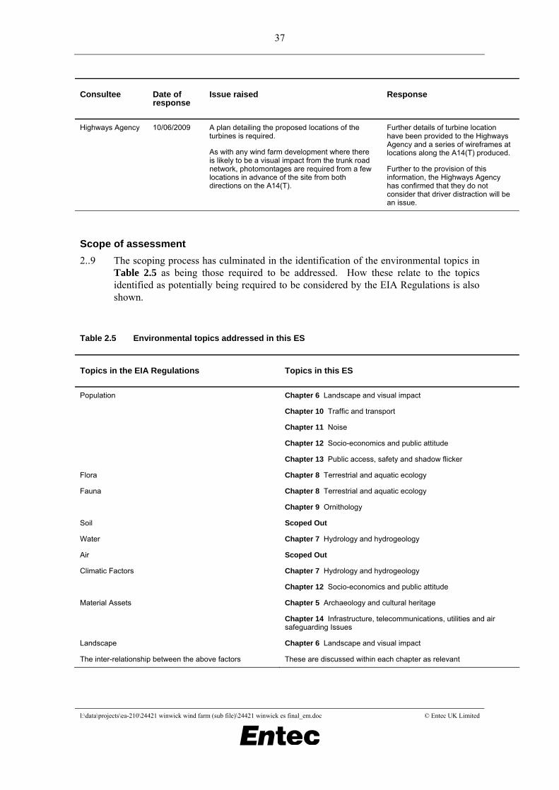
37
l:\data\projects\ea-210\24421 winwick wind farm (sub file)\24421 winwick es final_em.doc © Entec UK Limited
Consultee Date of response
Issue raised Response
Highways Agency 10/06/2009 A plan detailing the proposed locations of the turbines is required.
As with any wind farm development where there is likely to be a visual impact from the trunk road network, photomontages are required from a few locations in advance of the site from both directions on the A14(T).
Further details of turbine location have been provided to the Highways Agency and a series of wireframes at locations along the A14(T) produced.
Further to the provision of this information, the Highways Agency has confirmed that they do not consider that driver distraction will be an issue.
Scope of assessment 2..9 The scoping process has culminated in the identification of the environmental topics in
Table 2.5 as being those required to be addressed. How these relate to the topics identified as potentially being required to be considered by the EIA Regulations is also shown.
Table 2.5 Environmental topics addressed in this ES
Topics in the EIA Regulations Topics in this ES
Population Chapter 6 Landscape and visual impact
Chapter 10 Traffic and transport
Chapter 11 Noise
Chapter 12 Socio-economics and public attitude
Chapter 13 Public access, safety and shadow flicker
Flora Chapter 8 Terrestrial and aquatic ecology
Fauna Chapter 8 Terrestrial and aquatic ecology
Chapter 9 Ornithology
Soil Scoped Out
Water Chapter 7 Hydrology and hydrogeology
Air Scoped Out
Climatic Factors Chapter 7 Hydrology and hydrogeology
Chapter 12 Socio-economics and public attitude
Material Assets Chapter 5 Archaeology and cultural heritage
Chapter 14 Infrastructure, telecommunications, utilities and air safeguarding Issues
Landscape Chapter 6 Landscape and visual impact
The inter-relationship between the above factors These are discussed within each chapter as relevant
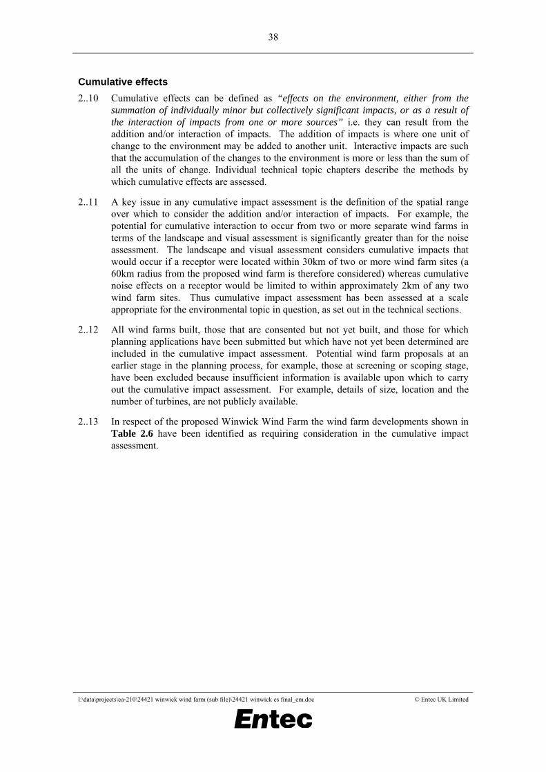
38
l:\data\projects\ea-210\24421 winwick wind farm (sub file)\24421 winwick es final_em.doc © Entec UK Limited
Cumulative effects 2..10 Cumulative effects can be defined as “effects on the environment, either from the
summation of individually minor but collectively significant impacts, or as a result of the interaction of impacts from one or more sources” i.e. they can result from the addition and/or interaction of impacts. The addition of impacts is where one unit of change to the environment may be added to another unit. Interactive impacts are such that the accumulation of the changes to the environment is more or less than the sum of all the units of change. Individual technical topic chapters describe the methods by which cumulative effects are assessed.
2..11 A key issue in any cumulative impact assessment is the definition of the spatial range over which to consider the addition and/or interaction of impacts. For example, the potential for cumulative interaction to occur from two or more separate wind farms in terms of the landscape and visual assessment is significantly greater than for the noise assessment. The landscape and visual assessment considers cumulative impacts that would occur if a receptor were located within 30km of two or more wind farm sites (a 60km radius from the proposed wind farm is therefore considered) whereas cumulative noise effects on a receptor would be limited to within approximately 2km of any two wind farm sites. Thus cumulative impact assessment has been assessed at a scale appropriate for the environmental topic in question, as set out in the technical sections.
2..12 All wind farms built, those that are consented but not yet built, and those for which planning applications have been submitted but which have not yet been determined are included in the cumulative impact assessment. Potential wind farm proposals at an earlier stage in the planning process, for example, those at screening or scoping stage, have been excluded because insufficient information is available upon which to carry out the cumulative impact assessment. For example, details of size, location and the number of turbines, are not publicly available.
2..13 In respect of the proposed Winwick Wind Farm the wind farm developments shown in Table 2.6 have been identified as requiring consideration in the cumulative impact assessment.

39
l:\data\projects\ea-210\24421 winwick wind farm (sub file)\24421 winwick es final_em.doc © Entec UK Limited
Table 2.6 Wind farm developments assessed for potential cumulative effects
Wind farm Location No. turbines
Hub height (m)
Rotor diameter (m)
Blade tip (m)
Status Status date
Burton Wold Wind Farm
Burton Latimer, Kettering
10 60 80 100 Operational April 2006
Brush Falcon Works (DeWind)
Loughborough 1 80 80 120 Approved September 2004
Burton Wold Wind Farm Extension
Burton Latimer, Kettering
7 60 80 100 Approved March 2008
East Midlands Airport
Leicestershire 4 31 27 45 Approved March 2008
Tesco Distribution Centre
Crick, Daventry 1 60 60 90 Approved January 2007
WW Steadfold Lane
Ketton, Rutland 2 60 70 95 Approved April 2007
Milton Keynes Milton Keynes 7 80 90 125 Approved November 2009
Swinford Near Lutterworth, Leicestershire
11 80 93 126.5 Approved December 2009
New Albion Between Rushton and Pipewell
7 65 70 100 Approved January 2010
Low Spinney Between the villages of Dunton Bassett to the north west, Ashby Magna
4 80 90 125 Submitted (LPA)
February 2009
Nun Wood Between Bozeat, Lavendon & Harold
12 80 90 125 Submitted (LPA)
January 2009
Yelvertoft Wind Farm
Between Yelvertoft, Crick and Lilibourne – east of the MI & near junction 19 of the M1 with the A14(T) and the M6
8 80 90 125 On appeal January 2010
Cotton Farm Between the villages of Graveley, Great Paxton, Toseland and Offord D'Arcy
8 80 93 126.5 Submitted (LPA)
December 2009
Harrington Harrington, Northamptonshire
7 80 93 126.5 On appeal February 2010
Airfield Farm Poddington, Bedfordshire
3 85.5 82 126.5 On appeal January 2010

40
l:\data\projects\ea-210\24421 winwick wind farm (sub file)\24421 winwick es final_em.doc © Entec UK Limited
Wind farm Location No. turbines
Hub height (m)
Rotor diameter (m)
Blade tip (m)
Status Status date
Gartree Wind Power
Between Market Harborough, Lubenham and Gartree, Leicestershire
3 80 90 125 Submitted (LPA)
November 2009
Watford Lodge
Watford, Northamptonshire
5 80 90 125 Submitted (LPA)
August 2009
Lilbourne Lilbourne, Northamptonshire
8 80 90 125 Submitted (LPA)
November 2009
Severn Trent Sewage Treatment Works
Wanlip, Leicestershire
1 80 52 132 Submitted (LPA)
December 2009
Fewcott Oxfordshire 4 80 90 125 Submitted (LPA)
December 2009
North Kilworth North Kilworth, Leicestershire
1 80 92 126 Submitted (LPA)
July 2008
Kelmarsh Kelmarsh, Northamptonshire
7 80 82m or 93m 121m or 126.5m
Submitted (LPA)
February 2010
Queniborough Queniborough, Leicestershire
4 80 90 125 Submitted (LPA)
February 2010
2..14 As noted in Section 1.1.3 and Section 1.4.7 the connection between the proposed Winwick Wind Farm and the distribution network is subject to a separate consent procedure. Network studies and discussions with E.ON Central Networks indicate that the most likely connection will be a 33kV local connection to the West Haddon primary sub-station in West Haddon, approximately 2km south of the proposed Winwick Wind Farm, with the cables running underground within the highway corridor. As such, no potentially significant environmental effects are anticipated, provided environmental legislation is complied with and any highway works are controlled as part of a Traffic Management Plan. Therefore, the connection between the proposed Winwick Wind Farm and the distribution network is not considered further within the technical assessments.
2.3 Community engagement
Commitment to community engagement 2.3.1 EC&R has a commitment to promoting an open and honest dialogue with statutory and
non-statutory consultees and the local community throughout the development process and acknowledges that the development of wind turbines and other renewable energy technologies can be controversial. Given that a significant amount of information is required to support any meaningful assessment of a wind farm project, it is a challenge to communicate such developments to a diverse range of people.

41
l:\data\projects\ea-210\24421 winwick wind farm (sub file)\24421 winwick es final_em.doc © Entec UK Limited
2.3.2 EC&R’s overall approach to community engagement is to:
• Provide information to help local communities understand the benefits and impacts of a wind farm in a variety of accessible formats;
• Identify key supporters and objectors to a development and their main interests or concerns;
• Provide feedback mechanisms to enable an understanding of and address any concerns that the local community may have including welcoming constructive suggestions on the project design; and
• Help the local community define the structure of a community benefits package.11
2.3.3 EC&R wants to ensure that the local community are consulted and involved throughout the development process. While every consultation programme is developed with a specific project and location in mind, there are a number of consultation tools that are likely to be used during the development process as follows:
• Public exhibitions;
• Leaflets;
• Questionnaires;
• Site visits; and
• Internet.
Community consultation activities 2.3.4 EC&R, Entec and BSG have undertaken extensive discussions with statutory and non-
statutory consultees, the local community and landowners/tenant farmers with the accumulated findings all having an influence over the evolution of the design. Consultation for the proposed Winwick Wind Farm has been completed through the following activities.
Consultation website 2.3.5 A project web page (www.eon-uk.com/winwick) has been set up to provide information
on the proposed Winwick Wind Farm. This is kept updated with milestones as the project progresses. Upon submission, the ES will be made available for download, providing easy access to the full information on the project. The website has been designed to encourage dialogue, comment and debate, with visitors able to leave feedback and register their support for the scheme. A dedicated e-mail address is provided ([email protected]), along with details of who to contact and the deadline dates for representations. The website has been promoted through the local media, newsletters and public exhibitions.
11 EC&R have committed to providing a community benefits fund of at least £28,000 per year for the life of the wind farm but the structure of this is still subject to agreement.

42
l:\data\projects\ea-210\24421 winwick wind farm (sub file)\24421 winwick es final_em.doc © Entec UK Limited
Public exhibitions, November 2009 2.3.6 Two public exhibitions were organised by EC&R to illustrate the progress of the EIA
process. The exhibitions were timed so that EC&R could present sufficient and meaningful information to the public yet allow time to incorporate suggestions raised and for revisions to be made where applicable to the ES.
2.3.7 The public exhibitions were held over two days in appropriately accessible venues at times convenient to the local community. The first exhibition was held at West Haddon Village Hall on Tuesday 10 November 2009 from 2pm to 9pm, and the second at Cold Ashby Memorial Hall on Wednesday 11 November 2009 from 1pm to 8pm.
2.3.8 Invitations to the exhibitions were delivered by hand to around 1,450 households in the villages of Cold Ashby, Coton, Elkington, Guilsborough, Thornby, West Haddon, Winwick and Yelvertoft. Announcements of the exhibitions were also made in the form of a press release and quarter-page colour adverts in local papers. A4 colour posters were put up in the vicinity of the village halls publicising the exhibitions.
2.3.9 Over the course of the two days 180 people attended. At the public exhibitions a range of information boards were provided, these displayed details of why the development is needed and showed specific details about the project and the impact it may have. This included a display of photomontages of how the proposed Winwick Wind Farm could look from viewpoints in the surrounding area.
2.3.10 Technical experts from EC&R and Entec were available at the public exhibitions to answer questions with visitors having the opportunity to request wireframe visualisations and noise predictions for their property. There were also representatives from Global Action Plan, a climate change awareness charity who had available interactive displays to show visitors the connection between their everyday behaviour and climate change.
2.3.11 Questionnaires were available at the public exhibitions for visitors to provide comments about the proposal. In addition to the comments received in response to the scoping request which are summarised in Table 2.4, 29 people provided comments on the proposed Winwick Wind Farm at the public exhibitions over the course of the two days. Generally comments in support of the wind farm related to the need for renewable energy. Negative responses are summarised as follows:
• Noise effects;
• Landscape and visual effects;
• Countryside ruin; and
• Cumulative effects.
Information days for access route, February 2010 2.3.12 EC&R organised two information days to display the access route proposals in the
villages of Thornby and Guilsborough. These villages were highlighted as being potentially affected by the preferred access route for abnormal loads.

43
l:\data\projects\ea-210\24421 winwick wind farm (sub file)\24421 winwick es final_em.doc © Entec UK Limited
2.3.13 The information days were held over two days at two locations: Thornby Village Hall on Monday 15 February 2010 and at Guilsborough Village Hall on Tuesday 16 February 2010 both from 4pm to 8pm.
2.3.14 500 households in Thornby and Guilsborough received hand-delivered invites and posters advertising the information days were put up around the villages.
2.3.15 Some of the exhibition boards on show at the public exhibitions held in November 2009 were displayed and information relating to the proposed access routes was exhibited. Details of vibration mitigation and drawings of the route through Thornby and Guilsborough were presented. Visitors were handed information sheets on the proposal and invited to provide comments. Technical experts from EC&R and Entec were available to answer questions on the proposed routes. Over the course of the two days 55 people attended.
2.3.16 Comments related to the suitability of the route for abnormal loads and traffic management.
Other activities 2.3.17 Other activities include:
• Submission of a scoping request to Daventry District Council;
• A presentation to Winwick Parish Council in June 2009 to introduce the project;
• Topic specific consultations with statutory and non-statutory consultees (reported in individual technical topic chapters);
• A tour of EC&R’s operational wind farm at Stag’s Holt in Cambridgeshire was organised for local residents on 4 November 2009. The tour was advertised on the invite for the public exhibitions in November 2009, and transport was provided by EC&R to the wind farm from Kelmarsh Hall. 26 people attended and members of the EC&R development and operations team were on hand to answer any questions; and
• In March 2010, a newsletter was produced to remind residents of the key features of the proposal and report back on the public exhibitions which took place in November 2009. The newsletter gave details of the main comments raised at the exhibitions, the progress of the proposal in relation to the planning timeline and details of a wind farm tour to Stag’s Holt wind farm in March near Cambridgeshire on 21 April 2010. The newsletter was distributed by hand to around 1,450 households in the villages of Cold Ashby, Coton, Elkington, Guilsborough, Thornby, West Haddon, Winwick and Yelvertoft.
2.4 Consideration of alternatives
Need for alternatives 2.4.1 The EIA Regulations require the ES to include “an outline of the main alternatives
studied by the applicant or appellant and an indication of the main reasons for his

44
l:\data\projects\ea-210\24421 winwick wind farm (sub file)\24421 winwick es final_em.doc © Entec UK Limited
choice”. The Daventry District Council scoping opinion also requested that the ES should demonstrate the suitability of the site taking into account other possible alternatives.
2.4.2 National planning policy makes it clear that there is no requirement for renewable energy developments to demonstrate an overall need for new renewable generation or a need to be located in a specific location. The Energy Review of 2006 and the White Paper of 2007 both contained a Renewables Statement of Need which states: “Renewable energy as a source of low-carbon, indigenous electricity production is central to reducing emissions and maintaining the reliability of our energy supplies at a time when indigenous fossil fuels are declining more rapidly than expected”.
2.4.3 The 2007 Energy White Paper provides further clarification stating at Section 5.3.67: “Recognising the particular difficulties faced by renewables in securing planning consent, the Government is also:
Underlining that applicants will no longer have to demonstrate either the overall need for renewable energy or for their particular proposal to be sited in a particular location”.
2.4.4 The 2007 Planning Policy Statement, PPS1 Supplement on Planning and Climate Change also emphasises that point, stating in Paragraph 20 that: “In particular, planning authorities should:
Not require applicants for energy developments to demonstrate either the overall need for renewable energy and its distribution, nor question the energy justification for why a proposal for such development must be sited in a particular location…”
2.4.5 Clearly the requirement for renewable energy as part of a decentralised and diverse portfolio of generating sources within the UK has been accepted at national policy level with wind energy widely recognised as being the most mature renewable energy technology currently available. This was highlighted in 2004 when the DTI and Carbon Trust published the Renewable Innovation Review12, which found that:
“Wind power, both on and off shore, can deliver almost all the required growth in renewable energy to meet the 2010 target and is likely to continue to be the dominant renewable energy technology out to 2020…….At present wind, both on and off shore, is the only economically viable and scaleable technology……There is sufficient UK practical wind resource to fulfil the 2010 target and 2020 aspiration, and so wind development dominates the near-term forecast of renewables growth”.
2.4.6 PPS22 supports the approach that wind turbines should be developed wherever commercially and environmentally acceptable, i.e. the requirement is only to demonstrate that this is a suitable development site rather than that it is the highest ranked in any form of sequential testing. This requirement is needed given the number of wind energy sites which will need to come forward in order to meet the Government’s renewable energy targets; the Member States of the European Union have agreed to a binding target that 20% of EU energy consumption must come from renewable sources by 2020 and it is proposed that the UK contribution to this should be
12 DTI and the Carbon Trust (2004) Conclusions of the Renewables Innovation Review.

45
l:\data\projects\ea-210\24421 winwick wind farm (sub file)\24421 winwick es final_em.doc © Entec UK Limited
to increase the share of renewables in our energy (electricity, heat and transport) mix from around 1.5% in 2006 to 15% by 2020.
2.4.7 Onshore and offshore wind are expected to provide the greatest part in meeting this target. It is expected that onshore wind will increase from 3GW in 2008 to 14GW in 2020 which equates to around 4,000 new 3MW onshore turbines in addition to the approximately 2,000 turbines already installed.
2.4.8 Given the clear policy context that there is no requirement to justify the viability of wind energy or the need to be located in a particular location. In this case, in EIA terms, by alternatives we mean alternative design solutions for the development site in terms of site layout, design, turbine height and turbine numbers. Nevertheless, the subsequent sections describe the site identification process and design criteria.
2.4.9 The comprehensive and thorough design process has considered a range of technical constraints and the potential for significant environmental effects in order to produce an appropriate design.
Site identification process 2.4.10 The careful selection of potential wind farm sites is a critical aspect of the overall wind
farm development process.
2.4.11 The EIA process started in 2007 when EC&R, as part of a UK wide search, carried out a high level assessment of Northamptonshire looking to identify suitable sites for wind development opportunities.
2.4.12 The site finding exercise allowed early identification of key technical, environmental and planning issues associated with each site which could either rule it out, or point towards further detailed studies and consultation which need to be undertaken as part of further phases of work in order to establish whether or not a project is feasible.
2.4.13 Each potential site was evaluated independently of each other, based on the criteria established for evaluation of potential new wind farm sites with the intention that any site that meets the basic criteria would progress to the next stage of evaluation. These included, but were not limited to:
• Land use and context: the existing land use and environmental or planning designations on or near the proposed wind farm site;
• Wind resource: the wind resource on the proposed wind farm site;
• Electricity grid: proximity to the electricity grid and its likely capacity;
• Transport infrastructure: proximity to public road infrastructure for construction, operation and maintenance;
• Residential amenity: proximity to dwellings and settlements;
• Landscape and visual capacity: potential landscape and visual effects of a wind farm; and
• Commercial viability.

46
l:\data\projects\ea-210\24421 winwick wind farm (sub file)\24421 winwick es final_em.doc © Entec UK Limited
2.4.14 In this site finding search, the proposed Winwick Wind Farm site was identified as a potential location for a wind farm development.
2.4.15 An initial assessment of the feasibility of the proposed Winwick Wind Farm site (the development site) was conducted looking at high level constraints and key criteria for wind farm development. The outcome highlighted that:
• The development site itself and its immediate surroundings had no statutory planning or environmental designations;
• There were no Local or Structure Plan policies which in principle precluded wind farm development;
• There was likely to be an appropriate wind resource;
• There were potentially suitable routes available to access the proposed development site;
• There were no constraints within the development site in relation to geology and ground conditions;
• Subject to the need for survey work to validate initial desk based assessments, there was no indication of any significant ecological or ornithological factors that would preclude wind farm development at the development site;
• Subject to a full noise assessment to validate initial noise predictions, there was no indication that the required noise levels could not be met at the development site;
• Subject to a comprehensive landscape and visual impact assessment, there were no landscape and visual constraints that would preclude wind farm development at the development site; and
• Although an initial desk study identified the presence of features of cultural heritage within, and in close proximity to the site (remaining ridge and furrow), the identified ridge and furrow is relatively common in the area and the fields appeared to have been recently ploughed, which would result in damage to the features.
2.4.16 The feasibility study confirmed Winwick as a suitable development site with the potential for 7 turbines with a maximum capacity of 17.5MW.
2.4.17 Following discussions with the landowner it was decided that the development site warranted further detailed environmental and technical assessment. EC&R and Entec built on the initial feasibility assessment findings and consultations, to design an appropriate, responsibly designed wind farm which is sensitive to the surrounding area.
2.4.18 EC&R continues to develop other proposed wind farm sites throughout the UK and across Europe and North America.
Design Criteria 2.4.19 The design solution for a development site is based on the considered application of the
following technical, economic and environmental criteria:

47
l:\data\projects\ea-210\24421 winwick wind farm (sub file)\24421 winwick es final_em.doc © Entec UK Limited
• The available wind resource needs to be sufficient to make the development financially viable, since, in general terms the greater the wind speed the more electricity and revenue will be generated by the development site. However, there is no absolute minimum wind speed required to make the development of a site viable, since the amount of predicted electricity generation needs to be offset against other factors such as the costs of the grid connection, required civil works and the turbines themselves;
• Ground conditions – ground conditions must be suitable for the installation of wind turbines, access tracks and cables. This will usually mean excavating down to find suitable load bearing strata on which to seat the foundations or can occasionally mean the use of piled foundation designs;
• Site topography – the site topography is computer modelled to establish the wind flow on and around the development site to provide guidance on the best locations for the wind turbines. This, of course, has to be balanced against other factors and effects to achieve an acceptable scheme;
• Distance between turbines – to minimise the turbulent interaction between wind turbines (wake effect), turbines should be separated by set distances both perpendicular to, and in line with, the prevailing wind direction. This design feature is a key factor in maximising the overall power generating capacity of a development site. Spacing requirements may vary between turbine manufacturers and are also subject to wind conditions;
• Proximity to occupied dwellings – wind turbines have to be located sufficiently far away from houses to protect local amenity with this aspect considered both in terms of visual amenity, noise amenity and in respect of shadow flicker. The use of computer generated visualisations and predictive modelling assist greatly in this process;
• Environmental constraints – features and areas of environmental sensitivity (ecology, archaeology, hydrology etc.) are identified and their implications considered. It is EC&R’s intention to seek to avoid or reduce these affects as far as possible through the design process – something facilitated by the EIA process;
• Landscape and visual design considerations are taken into account and the layout modified accordingly. Experienced landscape architects use their professional judgement aided by computer generated visualisations to carefully modify the number, layout and scale of turbines to achieve an acceptable design solution;
• Existing land use – whilst the wind turbines and their associated infrastructure occupy no more than 1.9% of the development site, the existing use of the land is considered in the layout of tracks and turbines. For example, existing track lines are used where practicable;
• Proximity to obstructions - such as tall trees or buildings which can create turbulence in the air flow and reduce the power generated from the development site. The design process considers standing turbines away from such obstructions or the relative size of tower and rotor to maximise the stability of airflow at the rotors;

48
l:\data\projects\ea-210\24421 winwick wind farm (sub file)\24421 winwick es final_em.doc © Entec UK Limited
• Health and Safety requirements - such as standoffs from roads, Public Rights of Way (PRoWs) and aviation infrastructure are all factored into the layout development to ensure appropriate safety standards are achieved and risks minimised; and
• Underground and overground services – pipelines and telecommunications links can be affected by wind turbine developments, therefore it is necessary to take into account the presence of such services when designing a wind energy development. Pipelines usually require standoffs at least equivalent to height to blade tip (plus an additional margin) as well as possible strengthening of proposed access crossings. Means of avoiding effects on telecommunications links vary and include: avoidance of defined Fresnel zones by blade swept areas; stand back from lines of sight or use of relays or in some cases re-routing of signals via other connection means.
2.4.20 The design solution for a development site also takes account of comments received during consultation (Section 2.3) with statutory and non-statutory consultees and the local community.
Design evolution 2.4.21 The main design changes resulting from the consultation and design process for the
proposed Winwick Wind Farm are summarised in Table 2.7. Prior to the end point being reached several design options were considered in terms of landscape and visual impact and noise; the final wind farm layout was considered the optimum design in terms of the number and arrangement of turbines taking into account environmental impact. The number of turbines has been reduced from eight to seven. The final wind farm layout is discussed in Chapter 3.
Table 2.7 Summary of design iterations
Issue addressed Detail of change
Start Point following site identification process by EC&R (energy optimisation only)
EC&R feasibility study identified that eight turbines with a blade tip height of up to 126.5m could be potentially accommodated.
Adjacent land use Turbines have been located at least 46.5m away from the development site boundary to avoid blade overhang onto neighbouring land.
Public roads Turbines have been located at least 126.5m (i.e. topple distance) away from these features in accordance with PPS22.
Public Rights of Way Turbines have been located at least 126.5m (i.e. topple distance) from footpaths and at least 200m away from bridleways in accordance with PPS22, supported by Northamptonshire County Council.
Telecommunication links Turbines have been located at least 100m from the Arqiva link which crosses the development site.
Watercourses and waterbodies Turbines have been located at least 20m from watercourses and waterbodies (e.g. ponds) located on the development site. Turbines have been located at least 50m from the spring issuing to the west of Winwick Warren Farm.

49
l:\data\projects\ea-210\24421 winwick wind farm (sub file)\24421 winwick es final_em.doc © Entec UK Limited
Issue addressed Detail of change
Source protection zones and flood risk areas identified by the Environment Agency
No infrastructure related to the proposed Winwick Wind Farm has been located in these areas.
Badgers Proposed turbines have been located at least 40m from any badger setts on the development site.
Bat flight lines There are a number of hedgerows crossing the development site which are potentially used as bat flight lines. Bats are a European protected species thus it was necessary to provide a standoff distance of at least 50m from the blade tip to any hedgerows, wooded areas and ditches.
The required standoff distance has been calculated in accordance with Natural England’s Bats and Onshore Wind Turbines Interim Guidance TIN05 (February 2009). Information on the height of hedgerows within the development site was obtained by BSG during ecology survey work.
Separation distances It is necessary to ensure adequate separation distance perpendicular to, and in line with, the prevailing wind direction. Separation distances are necessary to minimise turbulent interaction (wake effect) between the turbines which would affect the power generation capacity of the wind farm.
Archaeological impact All known archaeological features within the development site have been avoided. This followed a site visit, which confirmed that the area of ridge and furrow in the south western part of the development site (recorded in the Midland Open Field Project) has been ploughed up and there is no trace of it.
Landscape and visual amenity In determining the site layout a visual review of potential layouts was undertaken and several design iterations made to minimise as far as possible the visual impact upon nearby receptors. This included consideration of the potential extent of turbine visibility and their spatial inter-relationship, blade overlap, clustering, the relationship to backdrop/horizon, topographical fit and turbine ghosting. The visual analysis informed the decision that all turbines were to be situated in the southern part of the development site to the south of the public byway which bisects the development site thereby removing visually isolated outlier turbines from the design layout. Specifically a decision was taken not to pursue the option of two outlier turbines which could be accommodated in the northern strip of the development site due to the visual impact.
Noise It was necessary for noise levels at nearby residential receptors to meet the limits derived from the approach set out in ETSU-R-97 The Assessment and Rating of Noise from Wind Farms. To ensure these noise limits can be met at nearby properties the scheme was reduced to seven turbines and the turbines have been located at least 400m from residential properties.
Existing trees and hedgerows The access track routes were modified to incorporate existing field entrances and to avoid mature trees and hedgerows wherever possible.
Landowner interests The access tracks have been routed as far as possible along field boundaries as a result of discussions with the landowners.
End Point Seven turbines with a blade tip height of up to 126.5m.

50
l:\data\projects\ea-210\24421 winwick wind farm (sub file)\24421 winwick es final_em.doc © Entec UK Limited