1979 Mission Street.pdf
77
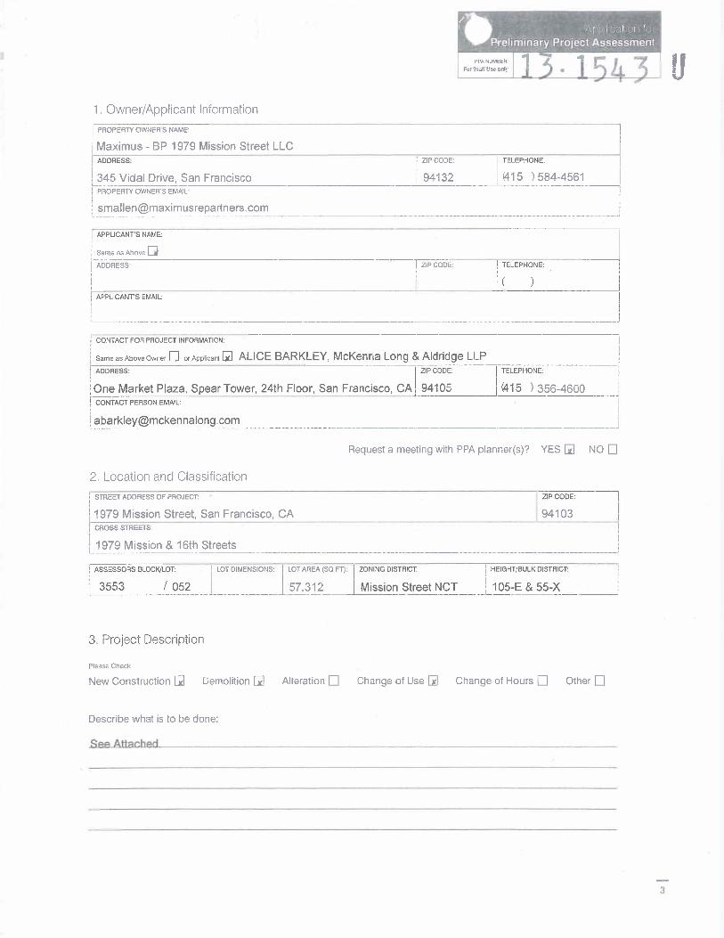
;v PPA NUS. 1 Owner/Applicant Information PROPERTY OWNERS NAME: Maximus - BP 1979 Mission Street LLC ADDRESS: ZIP CODE: TELEPHONE: 345 Vidal Drive, San Francisco 94132 015 ) 584-4561 PROPERTY OWNER’S EMAIL: smallenmaximusrepartners.com APPLICANTS NAME: Same as Above ADDRESS: ZIP CODE: TELEPHONE: APPLICANT’S EMAIL: CONTACT FOR PROJECT INFORMATION: Same avAboveOwner El or Applicant l_ALICE BARKLEY, McKenna Long & Aldridge LLP ADDRESS: ZIP CODE: TELEPHONE: One Market Plaza, Spear Tower, 24th Floor, San Francisco, CA 94105 (415 ) 356-4600 CONTACT PERSON EMAIL: abarkleymckennalong.com Request a meeting with PPA planner(s)? YES EI NO LI 2, Location and Classification STREET ADDRESS OF PROJECT: ZIP CODE: 1979 MissionStreet,SanFrancisco,CA 94103 CROSS STREETS: 1979 Mission & 16th Streets ASSESSORS BLOCK/LOT: LOT DIMENSIONS: LOT AREA (SQ FT): ZONING DISTRICT: 3553 / 052 57,312 Mission Street NCT HEIGHT/BULK DISTRICT: 105-E & 55-X 3. Project Description Please Check New Construction III Demolition Alteration El change of Use Change of Hours El Other El Describe what is to be done: 3
-
Upload
san-francisco-examiner -
Category
Documents
-
view
1.340 -
download
2
description
Document on 1979 Mission Street.
Transcript of 1979 Mission Street.pdf
�
;�v
PPA NUS.
1 Owner/Applicant Information
PROPERTY OWNERS NAME:
Maximus - BP 1979 Mission Street LLC ADDRESS: ZIP CODE: TELEPHONE:
345 Vidal Drive, San Francisco 94132 015 ) 584-4561 PROPERTY OWNER’S EMAIL:
smallenmaximusrepartners.com
APPLICANTS NAME:
Same as Above
ADDRESS: ZIP CODE: TELEPHONE:
APPLICANT’S EMAIL:
� CONTACT FOR PROJECT INFORMATION:
Same avAboveOwner El or Applicant l_ALICE BARKLEY, McKenna Long & Aldridge LLP ADDRESS: ZIP CODE: TELEPHONE:
One Market Plaza, Spear Tower, 24th Floor, San Francisco, CA 94105 (415 ) 356-4600 CONTACT PERSON EMAIL:
abarkleymckennalong.com
Request a meeting with PPA planner(s)? YES EI NO LI
2, Location and Classification
STREET ADDRESS OF PROJECT: ZIP CODE:
1979 MissionStreet,SanFrancisco,CA 94103 CROSS STREETS:
1979 Mission & 16th Streets
ASSESSORS BLOCK/LOT: LOT DIMENSIONS: LOT AREA (SQ FT): ZONING DISTRICT:
3553 / 052 57,312 Mission Street NCT
HEIGHT/BULK DISTRICT:
105-E & 55-X
3. Project Description
Please Check
New Construction III Demolition Alteration El change of Use Change of Hours El Other El
Describe what is to be done:
3
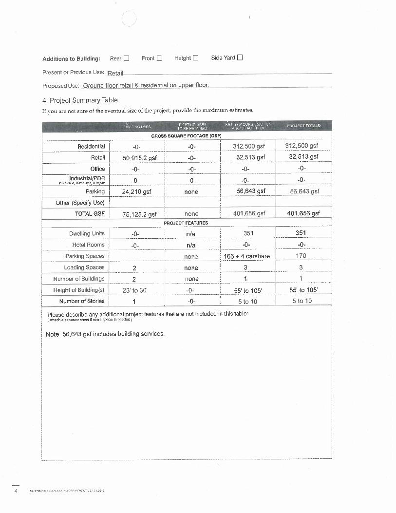
Additions to Building: Rear El Front E Height LI Side Yard LI
Present or Previous Use: Reta il
Proposed Use: Ground floor retail & residential on upper floor.
4. Project Summary Table
If you are not sure of the eventual size of the project, provide the maximum estimates.
GROSS SQUARE FOOTAGE (GSF)
Residential -0- -0- 312,500 gsf 312,500 gsf
Retail 50,915.2 gsf -0- 32,513 gsf 32,513 gsf
Office -0- -0- -0- -0-
lndustrial/PDR - - -0 - - Production. Distribution, & Repair - -
Parking 24,210 gsf none 56,643 gsf 56,643 gsf
Other (Specify Use)
TOTAL GSF 75,125.2 gsf none 401,656 gsf 401,656 gsf
PROJECT FEATURES
Dwelling Units -0- n/a 351 351
Hotel Rooms 1 -0- n/a -0- -0-
Parking Spaces none 1 166 + 4 carshare 170
Loading Spaces 2 none 3 3
Number of Buildings 2 none 1 1
Height of Building(s) 23 to 30’ -0- 55’ to 105’ 55 to 105’
Number of Stories 1 -0- 5 to 10 5 to 10
Please describe any additional project features that are not included in this table (Attach a separate sheet if more space is needed)
Note 56,643 gsf includes building services.
4 SAN FRANCISCO PLANNING DEPARTMENT V03.23.2012
EPA NUMB, It ForStati Uss only
e
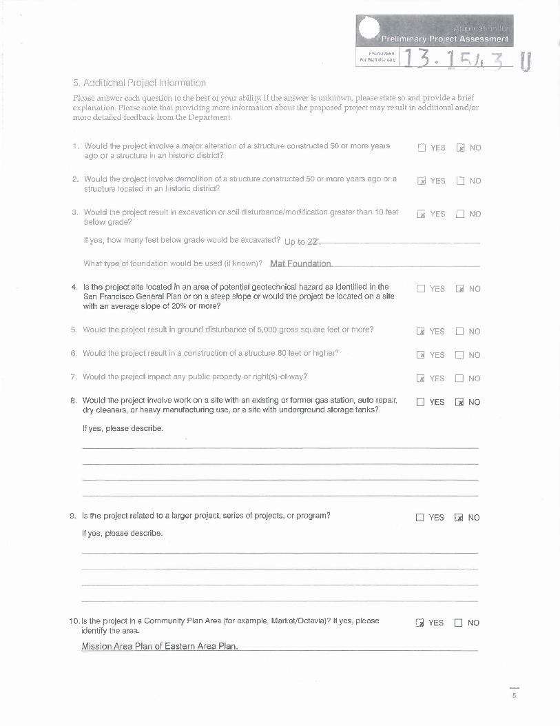
5. Additional Project Information
Please answer each question to the best of your ability. If the answer is unknown, please state so and provide a brief explanation. Please note that providing more information about the proposed project may result in additional and/or more detailed feedback from the Department.
1. Would the project involve a major alteration of a structure constructed 50 or more years LII YES Iil NO ago or a structure in an historic district?
2. Would the project involve demolition of a structure constructed 50 or more years ago or a iii YES fl NO structure located in an historic district?
3. Would the project result in excavation or soil disturbance/modification greater than 10 feet Eli YES U NO below grade?
If yes, how many feet below grade would be excavated? Up4o 22.
What type of foundation would be used (if known)? Mat foundation.
4. Is the project site located in an area of potential geotechnical hazard as identified in the LII YES Li NO San Francisco General Plan or on a steep slope or would the project be located on a site with an average slope of 20% or more?
5. Would the project result in ground disturbance of 5,000 gross square feet or more? Li YES U NO
6. Would the project result in a construction of a structure 80 feet or higher? 5 YES III NO
7. Would the project impact any public property or right(s)-of-way? IIj YES III NO
8. Would the project involve work on a site with an existing or former gas station, auto repair, EJ YES Li NO dry cleaners, or heavy manufacturing use, or a site with underground storage tanks?
If yes, please describe.
9. Is the project related to a larger project, series of projects, or program? El YES Ii NO
If yes, please describe.
10. Is the project in a Community Plan Area (for example, Market/Octavia)? If yes, please Li YES ü NO identify the area.
Mission Area Plan of Eastern Area Plan.
5
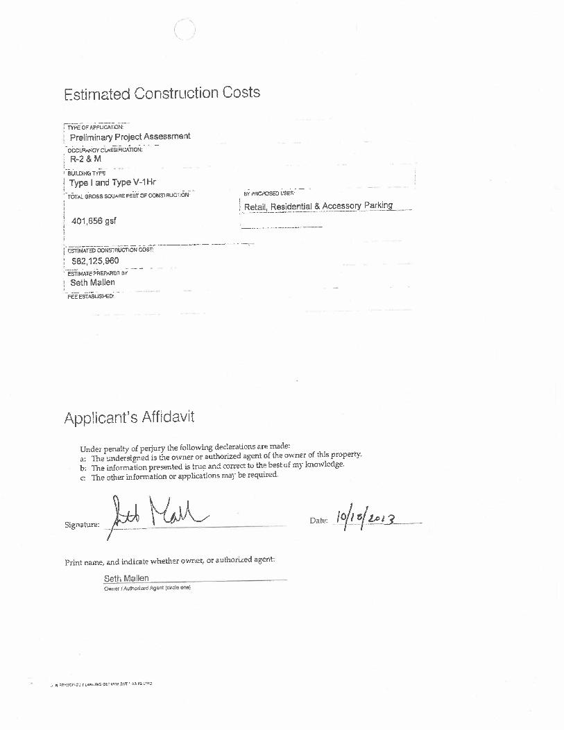
Estimated Construction Costs
TYPE OF APPLICATION:
Preliminary Project Assessment 000UPMr4CY CISSIFICATlON:
R-2&M
BUILDING TYPE
Type land Type V-i Hr
� TOTAL GROSS SOUAJE FEET OF CONM RUCTION,-
401,656 gsf
CSTIMATED CONSTRUCTION COST
$82125960 ESTIMATE PREPAREII 51
Seth Mallen
FEE ESTABLISHED’
BY PROPOSED USES -
Retail, Residential &Accessory Parking
Applicant’s Affidavit
Under penalty of perjury the following dedarations are made: a: The undersigned is the owner or authorized agent of the owner of this property. b: The information presented is true and correct to the best of my knowledge. C: The other information or applications may be required.
Signature: Date:
Print name, and indicate whether owner, or authorized agent:
Seth Mallen Owner! Authorized Agent (circle 0(10)
IN FP’- r LP1,INt1 DEr ASTS.5(IT 1,323 f q12

jTf Hilt
Applications listed below submitted to the Planning Department must be accompanied by this checklist and all required materials. The checklist is to be completed and signed by the applicant or authorized agent and a department staff person.
APPLICATION MATERIALS CHECKLIST
Application, with all blanks completed
300-foot radius map, if applicable :El
Address labels (original), if applicable
Address labels (copy of the above), if applicable
Site Plan JI Floor Plan
Elevations
Section 303 Requirements (shown on info, sheet)
Prop. M Findings
Photographs
Check payable to Planning Dept.
Application signed by owner or agent
Letter of authorization for agent El
NOTES:
Required Material. Write N/A" if you believe
the item is not applicable, (e.g letter of authorization is not required if application is
signed by property owner.)
Typically would not apply. Nevertheless, in a
specific case, staff may require the item.
Some applications will require additional materials not listed above. The above checklist does not include material needed for Planning review of a building permit. The "Application Packet" for Building Permit Applications lists those materials.
No application will be accepted by the Department unless the appropriate items on this checklist is completed. Receipt of this checklist, the accompanying application, and required materials by the Department serves to open a Planning file for the proposed project. After the file is established it will be assigned to a planner. At that time, the planner assigned will review the application to determine whether it is complete or whether additional information is required in order for the Department to make a decision on the proposal.

Acknovvedment and Sqnatures
OTHER APPLICATIONS THAT MAY BE REQUIRED:
By signing below, I acknowledge: That I have read and completed this form in its entirety; that I understand that receipt of these materials by the Department does not mean that the application has been accepted as complete; that all of the information provided in this application is accurate.
..Signature:
Print name, and indicate whether owner, or authorized agent:
Oi7Autborlzed Agent (circle One)
For Opartmeni Use Only
Application received by Planning Department:
By: - Date: -
Central Reception Planning Information Center (PlC) 1650 Mission Street Suite 400 1660 Mission Street First Floor San Francisco, CA 94103-2479 San Francisco. CA 94103-2479
TEL 4155586378 TEL 4155586377 FAX: 415,558.6409 Planning staff em availabla by pho and at the PlC WEB. http://www.sfpianfflng.org No appointment in necessary.

131’tX U
Preliminary Project Assessment Application 1979 Mission Street, San Francisco October 18, 2013 Page 1
ATTACHMENT TO PRELIMINARY ASSESSMENT APPLICATION
FOR BLOCK 3553, LOT 052
PROJECT SITE
The 57,312 sf(1.3 acre) Project Site (Block 3553, Lot 052), bounded by Mission, 16th and Capp Streets, is located in the Mission Street Neighborhood Commercial Transit District and the Mission Area Plan of the Eastern Neighborhood Plan ("EN Mission Area Plan"). The southern and western edges of the Project Site abut the 16 1h and Mission Streets BART station plaza. An aerial photograph of the Project Site is attached hereto as Exhibit 1. The Project Site straddles two height and bulk districts. The portion of the Project Site with frontage on Mission and 16 1h Streets is located in a 105-E height and bulk district. The remainder of the Project Site with frontage only on Capp Street is located in a 55-X height and bulk district. Copies of the zoning and height/bulk district maps are attached hereto as Exhibit 2.
The Project Site is improved with two buildings with a total of 50,915 gross square feet ("gsf’), both of which have basements. The 15,477 gsf one-story building with mezzanine and basement (1979 & 1985 Mission Street) building is approximately 23’ to 25.5’ high to the top of the parapet and is currently occupied by Waigreens. The 2950-2978 16th Street building contains approximately 35,438 gsf and is approximately 28’ to 30’ high to the top of the parapet, of which 22,068.7 sq. ft. (the space occupied by Dollar Store) is vacant. The remainder of the l6’ Street building is occupied by two restaurants, a bar and retail store. Most of the retail stores in this building have mezzanines. The northeast corner of the Project Site is a 24,210 sq. ft. surface parking lot with access from Capp Street. A copy of the existing site plan is attached hereto and collectively referred to as Exhibit 3.
The Project Site is fairly flat. The 185’ long frontage on Mission Street has a slight uphill slope of approximately 1’ from north to south toward 16 "’ Street. The 160’ long frontage on 16th Street slopes approximately 2’ downhill toward Capp Street. The frontage on Capp Street slopes approximately 2’ to the north. A copy of the topographic survey is attached hereto as Exhibit 4.
The Project vicinity is developed with 2 to 6 story mixed-use buildings. North of the Project Site are small scale residential buildings with ground floor retail on Mission Street, and Marshall Elementary School on Capp Street. On the opposite Mission Street block face is a vacant public school, retail/residential mixed use and other commercial use buildings. See existing land use map (ENFEIR p. 43 Figure 8) attached hereto as Exhibit 5. Block face and Project Site context photographs are attached hereto as Exhibit 6.
Preliminary Project Assessment Application 1979 Mission Street, San Francisco October 18, 2013 Page 2
PROJECT DESCRIPTION
1. Proposed Project
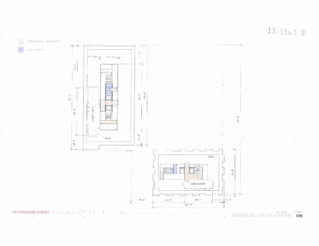
The Project Sponsor proposes to demolish all existing improvements on the Project Site and to construct a 5 to 10-story up to 105’ high, 345,013 sq. ft. building exclusive of a 56,643 sq. ft. basement parking garage. Off-street parking that meets the Planning Code requirements will be located in the basement garage level which will contain 161 off-street parking spaces (39 independently accessible spaces for retail use and 122 spaces for the residential units, of which 88 spaces will be stacker spaces). The basement garage and ground floor levels will also house approximately 166 Class 1 bicycle spaces and a minimum of 27 Class 2 bicycle spaces, meeting Planning Code requirements. Ingress and egress to the basement garage, three (3) off-street freight loading, and four (4) car-share spaces will be off Capp Street via a 20’ wide garage door and a 20’ curb cut.
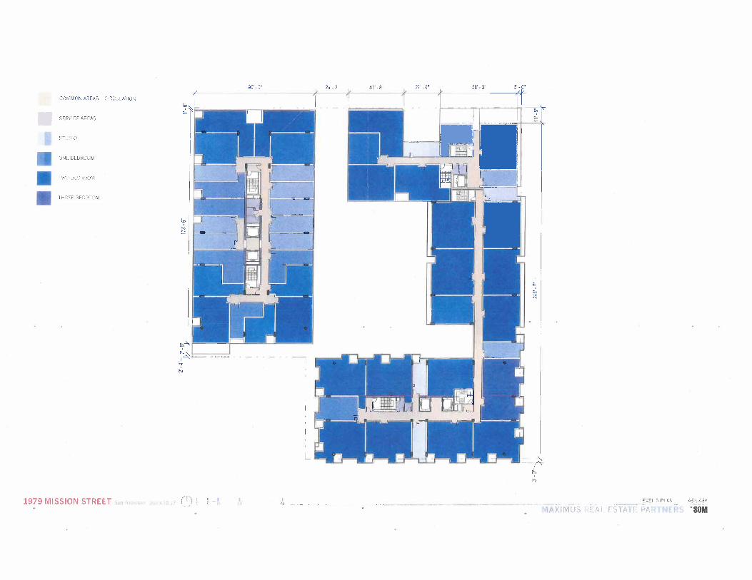
The ground floor will contain approximately 32,513 gsf ground floor retail, three (3) freight loading spaces, a van space, and four (4) car-share spaces. The 312,500 residential component will have 351 residential units (108 studio, 103 one-bedroom units, 133 two-bedroom units and 7 three-bedroom units).
Except for three (3) ground floor units fronting on Capp Street, there are three residential pods on the podium level. The ground floor retail spaces will have a minimum of 14’ floor to floor height with glass storefronts. The residential pod fronting on Mission Street will have 9 levels; the residential pod above the corner of 16" and Capp Street will contain 7 to 9 levels and the Capp Street residential pod will be 4 levels. Each residential pod will have its own entrance lobby, located on Mission Street, at the corner of 16th and Capp Street, and on Capp Street, respectively.
A 12,871 sq. ft. interior courtyard will be provided at the podium level, which is 22.45% of the lot area. Usable open space will be provided with a combination of private usable open space in the fonTn of decks and terraces and a portion of the inner courtyard, meeting the Planning Code requirements.’ The interior court and roof terraces will offer a variety of active and passive recreational spaces for all residents.
The current design includes 47 units with a minimum o’180 sq. ft. of private usable open space; 104 units with 36 sq. ft. of private usable open space, and with the balance provided through common usable open space, and approximately 19,961 sq. ft. of common usable open space through a combination of roofs and a portion of the interior courtyard meeting the usable open space requirements.
{footnote continued}

Preliminary Project Assessment Application 1979 Mission Street, San Francisco October 18, 2013 Page 3
The Project sponsors will work with BART and the City to improve the public open space of the BART Plaza that abuts the Project Site.
The Site Plan, floor plans, elevations, and photomontages are attached hereto as Exhibit 7.
2. Urban Design Considerations
The Project has been designed to be compatible with the neighborhood while implementing the visions of the EN Mission Area Plan. Mission Street is developed with low-rise commercial or mixed use buildings incorporating residential use over ground floor retail uses. Capp Street is more residential in character with finer scale buildings. The EN Mission Area Plan envisions buildings of 80’ to 85’ along Mission Street between 15 I and 17th Street, 85’ around the 24th Street BART Station, and 105’ feet around the 16th and Mission BART Plaza.
The Project has been designed to respect the current surrounding buildings while being one of the first projects to implement the vision of the EN Mission Area Plan. One major issue with the current buildings on the Project Site is the blank facades facing the BART Plaza and on Mission and Capp Streets, and to a lesser degree on 16t1i Street. See Exhibit 6. The lack of interaction between the current buildings and the neighborhood is a significant contributing factor to the high crime rate at the intersection of 16 I and Mission Streets, which in turn deters and limits the public’s use of the BART Plaza open space for only access to the BART trains.
The Project is designed to create a recognizable landmark for this all-important transit node. The proposed design utilizes a unique mix of architectural elements and features to establish a relatable building scale to the surrounding lower buildings in order to enhance pedestrian visual interest and to strengthen Mission Street as a neighborhood retail street.
To emphasize the continuous neighborhood-serving ground floor retail, store fronts will wrap around the BART Plaza and continue along Mission and 16"’ Streets. Retail spaces will feature welcoming high ceilings and a large expanse of display glass to spark pedestrian interest and provide a safe, engaging revitalization of the BART Plaza. The Project includes 15’ setbacks at the ground level and 10’ setbacks for the upper floors from the common property line shared with BART to provide a pedestrian-friendly frontage, and to allow neighborhood-serving retail, cafes and restaurant uses at the ground level. A strong storefront cornice line will separate and establish the transition to the
(continued from previous page

Preliminary Project Assessment Application 1979 Mission Street, San Francisco October 18, 2013 Page 4
residential component above. This rejuvenation of the BART Plaza is further enhanced by locating the residential public amenities at level 2 to face the Plaza and to provide additional eyes on the street. The extended balconies facing the BART Plaza identify the Project Site’s location as a major pedestrian and transit node of the City. See Exhibit 8.
The Mission Street residential component respects the future heights of adjacent buildings, as described in the EN Mission Area Plan, by introducing a transition in building articulation at the 8-story level. The Project’s Mission Street façade incorporates various window types that reflect and distinguish the different residential unit types, reducing the building’s mass and scale.
The 16th Street residential component defines the corner of 16th and Capp Street, reaching the 105’ height in the EN Mission Area Plan and stepping down to 55’ commensurate to the lower-scaled buildings on the opposite side of Capp Street. The Project design embraces a setback at the 7th floor (from the BART Plaza) to allow for additional sunlight access into the residential courtyard, the adjacent school and the BART Plaza. The 16th Street façade creates 3 off-set tiers of bay windows. The balconies at levels 5 and 8 relate to the heights of the existing and future buildings.
The Project’s Capp Street building façade will step down from 105’ to 55’ in order to reinforce the design of the corner pod and to relate to the more intimate scale of the residential buildings on the east side of Capp Street. The 55’ high portion will be articulated into three distinct façade segments to decrease the visual length of the building with the last segments that include three (3) ground-floor residential units. Each of these ground floor residential units will have its own private entry stoop that faces directly onto the street, creating an appropriately scaled, finer-grain street front that recalls the older residential buildings across the street.
The Project is designed to achieve or exceed a LEED Silver rating. The Project may include sustainable design features, such as sustainable building materials; energy-efficient building envelope; possible use ofphotovoltaics and/or solar hot water roof panels; rooftop rainwater capture; landscaped courtyard and roof gardens to limit any heat island effect; radiant heating; Energy Star appliances; low flow plumbing fixtures and low-VOC finishes.
The Project will also activate the building frontage facing the BART Plaza and will work with BART to enhance the use of the Plaza as public open space. The current conceptual approach to improvements to the BART Plaza includes engaging local artists, who may work with school children of Marshall Elementary School on the resurfacing of the BART Plaza as public art appropriate for the Mission neighborhood context.
The Project’s proposed streetscape improvements will comply with the Mission District Streetscape Plan and will be submitted to the Planning Department when the design details are more developed.

Preliminary Project Assessment Application 1979 Mission Street, San Francisco October 18, 2013 Page 5
In order to improve pedestrian safety and accommodate an underground sidewalk vault at Capp Street, the Project proposes to widen the Capp Street sidewalk to 12 -15’ and to create a bulb-out at the intersection of 16 ’1’ Street, which would calm traffic and improve pedestrian safety as identified in the Mission District Streetscape Plan. The bulb-out will improve walkability by shortening street crossing distances. and provide safer access for children and families going to the adjacent school. A bioswale feature maybe considered for the areas on Capp Street immediate adjacent to the ground floor residential units.
Approvals Required:
The Project will require the following approvals:
A. Large project authorization in EN (329);
B. Conditional use authorization pursuant to Section 303 for � lot size; and � use size limitations.
C. Deviation from the following sections of the Planning Code pursuant to §329: � rear yard (l34); � Bulk limitations; and � unit size mix ((209.6(d)(2).) � Section 140 Dwelling unit exposure to open space
D. Subdivision and Condominium map approval from DPW Bureau of Streets and Mapping;
E. Encroachment permit for sidewalk underground vault from DPW Bureau of Streets and Mapping;
F. Capp Street sidewalk Bulb-out from DPW Bureau of Streets and Mapping;
G. Building Permit from the Department of Building Inspection; and
H. BART approval for improvements to the Mission and 16 t1i BART Station plaza.

Preliminary Project Assessment Application 1979 Mission Street, San Francisco October 18, 2013 Page 6
APPLICABLE PLANNING CODE PROVISIONS
A Applicable Planning Code Sections
Zoning: NCT Mission Street Neighborhood Commercial Transit
The Property is located in the Fringe Financial Service Restricted Use District (FFSRUD). Fringe financial services are not permitted pursuant to § 249.35.
Dwelling Unit Limited by the building envelope with no limit on the number of Density dwelling units (736.91).
Large Project in A large project is defined as in excess of 75’ in height or in excess of Eastern 25,000 sq. ft. (329). Under this section, a large project is subject to Neighborhood design review by the Planning Commission under the criteria set forth in
§329 and may seek exceptions to the Planning Code requirements listed under §329(d), including deviations from the unit size mix requirement (207.6(d)(2)).
Planned Unit The Project Site is in excess of 1/2 acre and can be developed with a Development Planned Unit Development (PUD), which will allow deviations from
certain quantitative standards of the Planning Code. A PUD requires a conditional use authorization (304).
Dwelling Unit Governed by building envelope with no limit on the number of dwelling Density units (736.91).
Lot Size: Conditional use approval required for new construction on lots with 10,000 sq. ft. and above (736.11).
Floor Area Ratio: 3.6 to 1 (124(a)(b)); Not applicable to residential use (736.20).
Use Size Principally penTnitted up to %,999 sq. ft. and conditional use required for use size in excess of 6,000 sq. ft. (§ 736.20).

Preliminary Project Assessment Application 1979 Mission Street, San Francisco October 18, 2013 Page 7
Usable Open 80 sq. ft. if private usable open space; and 100 sq. ft. if common usable Space open space (736.93). [Per Residential Unit] For units less than 350 sq. ft. plus a bathroom, 26.67 sf. ft. if private
usable open space, and 35.56 sq. ft. if common usable open space
Street Trees: Required for each 20’ of street frontage (428).
Ground Floor Floor to Floor height shall be a minimum of 14’ (415. 1(c)(4)(13)). Height
Active use, except for parking, loading and building access, are required Street frontage for ground floor street frontages (§415. 1(c)(2)). uses
Rear Yard Minimum 25% of lot depth at residential levels (736.12).
Off-Street No off-street parking is required. Maximum allowed is 0.5 % per unit. Parking, Up to a maximum of 0.75 per unit is conditionally permitted (§ 155(r)). Residential
Off-Street Parking For Retail, up to 1 space per 1,500 sfofoccupied floor area. none-residential
For retail grocery stores with over 20,000 gsf, up to I space per 500 sq. ft. of occupied floor area, and subject to the conditions and criteria of Section 151.1(g). Conditional use required for up to 1 space per 250 sq. ft. of occupied floor area for that area in excess of 20,000 sq. ft.
Off-Street Freight In general, none required if gross floor area is less than 10,000 sf. The Loading:
number required will depend on the type and use sizes in the building (Table 152.1.).
Car Share Spaces Car-share parking spaces do not count against accessory off-street parking spaces (§ 166).
1 space for 50-200 dwelling units, 2 spaces plus one for every 200 dwelling units over 200, or a total of 2 spaces for the residential component (Table 166). 1 space for 24-49 spaces provided for non-residential use (Table 166).

Preliminary Project Assessment Application 1979 Mission Street, San Francisco October 18, 2013 Page 8
Bicycle Parking For projects over 50 dwelling units, 25 Class 1 spaces, plus one Class 1 space for every 4 dwelling units over ( § 155.5 and Table 155.5).
Residential Use (Table 155.2) One Class 2 space for every 20 units.
For a project with 351 units, 100 Class 1 spaces and 18 Class 2 spaces are required.
One Class 1 space for every 7,500 sq. ft. of occupied area of retail sales, including grocery stores.
Non-residential One Class 1 space for every 7,500 sq. ft. of occupied area of Uses restaurant/financial service/personal service uses.
One Class 2 space for every 2,500 sf of occupied floor area of retail uses, with a minimum of 2 spaces. For retail uses in excess of 50,000 sf, 10 class 2 spaces plus 1 space for every additional 10,000 sf of occupied area.
One Class 2 space for every 750 sq. ft. of occupied area for personal services/financial services, restaurants, limited restaurants and bars, but no less than Two.
Drive-Up Facility: Not permitted.
Walk-Up Facility: Pennitted if recessed 3 feet; conditional use if not recessed (§145.2(b)).
Hours of No limit (§736.27), except Medical cannabis dispensaries are limited to Operation: the hours of 8 am and 10 pm.
Signage: See Article 6 of the Planning Code.
Fringe Financial Not Permitted (736.25). use:
B. EXACTIONS
Impact Fees. The following Impact Fees apply to the Project:
(a) Transit Impact Development Fee (TIDF) (’411.3).

Preliminary Project Assessment Application 1979 Mission Street, San Francisco October 18, 2013 Page 9
(b) Eastern NeiJiborhood Impact Fee and Public Benefit (’ 423).
The amount of the impact fee is based on Tier 1 because this Property did not benefit from any increase in height. See. § 423.2(a) (1). Under Tables 423.3A and 423.313, the impact fee is $8/gsf for the new additional nonresidential development and $2/gsf to replace the existing nonresidential uses. Gross square footage includes circulation space (bathrooms, hallways, etc.) (423.3(c)).
2. Affordable Housing.
(a) Inclusionary Affordable Housing Program ( 415).
The Project Applicant is considering the following options:
Designate 12% of the on-site units to be affordable units (Sec 415.5(b)); or
2. Provide 20% of the affordable housing off-site; or
3. Pay an in-Lieu Fee equal of 20% of the total number of units by size; or
4. A combination of all three above options; or
As a Tier A project(41 9.2(a)(2).), dedicate 30% of the total developable area of the Project Site to the City for the purpose of construction of a minimum of 40 affordable units. (§ 419.5 (2)) The City may accept dedicated sites that meet the requirements of § 419, in combination with fees or on-site units (419.5 (2)(G)).
6. The 40% two- bedroom unit requirement may be waived if 100% of the affordable housing units contain two or more bedrooms. (207.6 and §329.)
ENVIRONMENTAL ISSUES
The Project is located in the EN Mission Area Plan area. A Final Environmental Review for the Eastern Neighborhood Plan ("ENEIR") was certified on August 7, 2008. A review of the ENEIR demonstrates that the Project meets the criteria to qualif y’ for a Community Plan Exemption.

Preliminary Project Assessment Application 1979 Mission Street, San Francisco October 18, 2013 Page 10
1. Land Use
The Project is located in the Mission Street NC-T District where ground floor retail and upper floor residential are principal permitted uses; housing on upper floors is encouraged. The Project is consistent with the planned use in the Mission Street NC-T district and EN Mission Area Plan, and is compatible with the surrounding uses. The proposed Project will have no adverse impacts on Land Use because PDR uses are not permitted in this district or in its predecessor district.
2. Plans and Policies
The Project will provide ground floor retail and new housing units on the upper floors, including permanently affordable units. The Project will comply with the City’s affordable housing requirements. Usable open space will be provided on the roof and portion of the interior court in compliance with Planning Code requirements. The Project’s proximity to BART and the Mission Street Transit Corridor will promote the City’s Transit-first Policy. The Project will comply with the applicable Planning Code requirements and is consistent with the objectives and Policies of the EN Mission Area Plan.
The Project, located in the EN Mission Area Plan and NC-T corridor, will be consistent with the objective and policies of the following General Plan elements:
� Commerce and Industry Elements - it is a mixed use building with ground floor commercial. See pp. 87-90 of ENFEIR.
� Community Safety Element - the building will meet current seismic and fire safety standards of the Building Code. See p. 89 of ENFEIR.
� Environmental Protection Element - the building will increase transit use and decrease Greenhouse gas emission. The building will be designed to meet Title 24 standards (see p. 89 of the FFEIR) and will meet or exceed LEED Silver standards.
� Housing Element - the Project will add 351 dwelling units to the City’s housing stock, with 12% of the units being penTnanently affordable. See pp. 91-95 of the ENFEIR.
� Recreation and Open Space Element - the Project will provide usable and other types of open space for residents and will provide improvements to the BART Plaza. See pp. 96 and 97 of the ENFEIR.

Preliminary Project Assessment Application 1979 Mission Street, San Francisco October 18, 2013 Page 11
� Transportation Element - this is the ideal site for high density housing in that the Project has immediate access to Muni on Mission and 16111 Streets and is adjacent to the BART Station. See pp. 97-99 of ENFEIR and detailed discussion below.
� Urban Design Element - the Project is consistent with many of the objectives and policies of the Urban Design Element and the EN Mission Area Plan.
The Project’s compliance with the City’s General Plan Objectives and policies will be discussed in detail in the Conditional Use Application. The EE Application will identify the General Plan Objectives and policies to be considered.
3. Visual Quality and Urban Design
The EN Mission Area Plan calls for anew 105’ building at Mission and 16th Streets. The 55’ height limit governing the remainder of the Project Site with frontage only on Capp Street will provide a logical transition to the neighboring buildings to the east and north. The proposed Project is consistent with the EN Mission Area Plan. The ENEIR finds no adverse impacts on the visual quality of the Mission Area Plan, including the Project Site, if developed according to the plan.
The design of the building described in the Project Description section above and as shown on the photomontages is compatible with the urban context envisioned by the EN Mission Area Plan. As a large project, the Planning Commission will review the Project design’s compliance with the criteria set forth in §329(c).
4. Population, Housing, Business Activity, and Employment
No residents will be displaced by the Project. The Project will include ground floor retail for neighborhood-serving businesses. The Project Sponsor will give the existing commercial tenants the right of first refusal to return to the new building. The anticipated increase in population, residential density, affordable housing, retail establishments and related employment opportunities associated with the Project are consistent with the ENEIR analysis. The Project as designed will not result in potential significant adverse effects on population, housing, business activity and employment not already studied during the ENFEIR process.
I/I
I/I

Preliminary Project Assessment Application 1979 Mission Street, San Francisco October 18, 2013 Page 12
Transportation, Circulation and Parking
Trip Generation - Existing
The existing 35,438.2 sq. ft. of occupied general retail uses on the Project Site generates 4,762.2 daily person trips, of which 507 person trips occur during the PM peak hour. 2
Alternative 1 - 351 residential units: (108 studio, 103 one-bedroom units, 133 two-bedroom units and 7 three-bedroom units), 26,667 gsf of grocery store and 5,846 gsf of restaurants/cafes.
Trip Generation - Proposed
The residential component will generate a total of 2,982.5 daily person trips of which 516 person trips occur during the PM peak hour. The mode split of the 516 person trips are 120 vehicular trips, 196 transit trips, 120 walk trips, and 80 other trips.
It is anticipated that the proposed retail space with a 26,667 gsf grocery store will generate 7,920 daily trips of which 578 trips occurs during the PM peak period. The 5,846 gsf of restaurants/cafes 3 will generate 1,169 daily person trips, of which 158 trips will occur during the PM peak hour. The Alternative 1 retail uses will generate 736 person trips during the PM peak period. Of the 229 net new non-residential PM peak hour trips, 147 will be trips will be by automobile, 28 will be transit trips, 49 will be walking and 5 by other modes.
Net New Trips
Currently, there are 20,141.9 gsf of general retail (Walgreen & Hwa Lei Market) and 8,704.6 gsf of restaurant/bar. For transportation analysis, the vacant 22,068.7 sf store previously occupied by The Dollar Store is not included in the trip generation calculation. The general retail use generates 3,021.28 daily person trips (150 per 1,000 gsf) of which 272 trips occur during the PM peak period. The restaurant/bar use generates 1740.92 daily person trip (200 per 1,000 gsf), of which 235 trips occur during the PM peak period. The current retail uses generates 507 person trips during the PM peak hour.
A portion of 5,846 gsf will be rented to general retail tenants. Allocation of all 5.846 gsf for restaurant/cafØ use will maximize the trip generation for these spaces.

Preliminary Project Assessment Application 1979 Mission Street, San Francisco October 18, 2013 Page 13
The 516 PM peak period trips generated by the residential use will be new trips. There will be a net increase of 229 net new retail use trips during the PM peak period. The Project will generate a total of 745 net new person trips during the PM peak hour and a total of 193 net new vehicle trips during the PM peak Hour.
Alternative 2 - 351 residential units: (108 studio, 103 one-bedroom units, 133 two-bedroom units and 7 three-bedroom units), 12,000 gsfof general retail use, 16,500 gsf of grocery store and 4,013 sq. ft. of restaurant/CafØ/bar.
Trip Generation - Proposed
The residential component will generate a total of 2,982.5 daily person trips of which 516 persons trips occur during the PM peak hour. The mode split of the 516 person trips are 120 vehicle trips, 196 transit trips, 120 walk trips, and 80 other trips.
12,000 gsf of general retail uses will generate 1,800 daily person trips, of which 162 person trips will occur during the PM peak hour. Of the 162 general retail PM peak hour trips, 105 will be trips by automobiles, 19 will be transit trips, 35 will be walking and 3 by other modes. A 16,500 gsf grocery store will generate 4,900.5 daily trips of which 358 person trips occurs during the PM peak hour. Of the 358 grocery store PM peak hour trips, 230 will be trips by automobile, 43 will be transit trips, 78 will be walking and 7 by other modes. The 4,013 gsf of restaurants/cafes 4 will generate 803 daily person trips, of which 108 trips will occur during the PM peak hour. Of the 108 restaurant/Cafe PM peak hour trips, 70 will be trips by automobile, 13 will be transit trips, 23 will be walking and 2 by other modes
Under Alternative 2 retail uses, there will be a total of 628 non-residential person trips during the PM peak hour. Of the 121 net new non-residential PM peak hour trips, 78 will be trips will be by automobile, 14 will be transit trips, 26 will be walking and 3 by other modes.
Net New Trips
The 516 PM peak hour trips generated by the residential use will be new trips. There will be a net increase of 121 net new retail use trips during the PM peak hour. The Project will
A portion of 5,846 gsf will be rented to general retail tenants. Allocation of all 5.846 gsf for restaurant/cafØ use will maximize the trip generation for these spaces.

Preliminary Project Assessment Application 1979 Mission Street, San Francisco October 18, 2013 Page 14
generate a total of 637 net new person trips during the PM peak hour and total of 156 net new vehicle trips.
Alternative 3 - 351 residential units: (108 studio, 103 one-bedroom units, 133 two-bedroom units and 7 three-bedroom units), 28,000 gsf of general retail and 4,513 gsf of restaurant/CafØ/Bar.
Trip Generation - Proposed
The residential component will generate a total of 2,982.5 daily person trips of which 516 persons trips occur during the PM peak hour. The mode split of the 516 person trips are 120 vehicular trips, 196 transit trips, 120 walk trips, and 80 other trips.
28,000 gsf of general retail uses will generate 4,200 daily person trips, of which 378 person trips will occur during the PM peak hour. Of the 378 net new non-residential PM peak hour trips, 243 will be trips will be by automobile, 45 will be transit trips, 82 will be walking and 7 by other modes. The 4,513 gsf of restaurants/cafes 5 will generate 903 daily person trips, of which 122 trips will occur during the PM peak period. Of the 122 restaurant/CafØ person trip during the PM peak hour, 78 will be trips will be by automobile, 15 will be transit trips, 27 will be walking and 2 by other modes.
Under alternative 3 retail uses, there will be a total of 500 non-residential person trip during the PM peak hour, resulting in a modest reduction of 6 PM peak hour non-residential vehicular trips.
Net New Trips
During the PM peak hour, there will be 509 PM person trips and 107 vehicle trips all of which will be new trips generated by the residential use.
See Exhibit 9 for a trip generation calculation.
A portion of 5,846 gsf will be rented to general retail tenants. Allocation of all 5.846 gsf for restaurant/cafØ use will maximize the trip generation for these spaces.

Preliminary Project Assessment Application 1979 Mission Street, San Francisco October 18, 2013 Page 15
Circijlc,tinn
The Project Site is on the Mission Transportation Corridor and directly adjacent to the 16111 and Mission BART station. Muni line Nos. 14, 14L and 49 stops are in front of the Project Site and directly across the street on Mission. Muni line Nos. 22 and 33 travels on 16th Street. To avoid conflict with transit, the ingress and egress to freight loading and off-street parking will be off Capp Street via a single entrance. The access to the lobby of the residential units will be via all three street frontages, 16t1, Mission and Capp Streets, in order to reduce pedestrian congestion and help to create a safe neighborhood environment.
Table 41 on page 272 of the ENFETR shows the current level of service (LOS); the 16’h/Mission intersection operates at LOS C, which will degrade to LOS D under all options studied. Therefore, the proposed Project will not have a significant impact on the surrounding intersections. The Project Applicant is working with a transportation engineer on solutions to minimize the impacts on Capp Street traffic from cars exiting from the garage.
Off-street Parking/Loading
The basement garage will have 161 spaces available.
The three (3) freight loading spaces and four (4) car share spaces will be located on the ground level. The off-street parking, freight loading and car-share spaces will share a 20’ wide garage entrance off Capp Street. The number of off-street freight loading and car share spaces will meet Planning Code requirements.
The Planning Code requires 43 off-street parking spaces for grocery store use with more than 20,000 sq. ft. of occupied area. Only 39 spaces are allocated to retail uses. 6 The residential component of Project will generate a demand of 421 off-street parking spaces 7 with only 122 spaces provided for residential. While the Project will have an off-street parking deficit, the City does not recognize parking deficits as a significant impact on the environment.
6 Assuming grocery store and restaurant/CafØ uses. 7 The Transportation Guidelines published by the Department show 1.1 space per studio or 1-BR. 1.5 for 2-13R or more. For affordable housing, 0.45 space for studio & 1 BR, and 0.92 for 2-13R or more units. The residential component of the project will generate 421 (211 for studio and 1-BR and 140 for 2- and 3-1311s) without discounting the lower demand rate for affordable units on site.

Preliminary Project Assessment Application 1979 Mission Street, San Francisco October 18, 2013 Page 16
The Project Site is in a transit-rich area with M1JNI Stops and a BART station within one hundred (100) feet of the Project Site. It is anticipated that the residents will use public transit for work trips as well as non-work trips, thereby promoting the City’s Transit First policy. The availability of four (4) car-share vehicles on-site will further discourage automobile ownership.
Tvnn cif
The Project Site is adjacent to the BART Station and MUNI Line Nos. 14, 14L, 33, 49 and 22.
Table 42 on page 282 of the ENFEIR shows that MUNI Line Nos. 14, 14L, 33, 49 and 22 will exceed maximum capacity during PM Peak hours at their respective maximum load points. The ENFEIR acknowledged that when the EN Plan is implemented, the potential significant impact on MUTNI could not be fully mitigated. (ENFEIR p.282.) Although implementation of the EN Plan will have a potential significant impact on MUNI, implementation of Mitigation Measures E-5, E-6, E-7, E-8, E-9 and E- 10 by the City will address the potential significant impacts. Implementation of one or more of the ENFEIR Transportation mitigation measures cited above will improve MIINI services citywide. See ENFEIR, pp. S-35 to S-40 and pp. 503-506.
The ENFEIR failed to take into consideration that all BART trains stop at this BART station and that the Clipper Cards can be used on BART within the City. BART serves as major transit hub to all employment centers in the City, the East Bay and to SF0. The Civic Center is one stop away; Union Square is two; the downtown financial district stations (Montgomery and Embarcadero) are three and four stations away, respectively. From the Embarcadero Station, the N and T MUNI Metro lines connect to Caltrans Station (which has service south as far as Gilroy). The T line continues on to the UCSF Mission Bay Campus. BART’s capacity utilization at the 16 th & Mission Station is 18% to the East Bay with the maximum load point (MLP) at the Embarcadero Station and 68% to Peninsular/South Bay with the MLP at the Civic Center Station.
6. Noise
Construction noise is governed by the City’s Noise Ordinance. The major contributor to ambient noise is traffic. The Project Site is on Mission and 16th Streets. Once the demolition of the existing buildings and the construction of the new buildings are completed, the

Preliminary Project Assessment Application 1979 Mission Street, San Francisco October 18, 2013 Page 17
residential and retail activities associated with the Project will not contribute to an increase in the ambient noise level.
The Project will comply with Noise Insulation standards in Title 24 of the California Code of Regulations and will follow the window assemblies and other recommendations of the acoustical engineer for the Project. See Mitigation Measure F-3 of the ENFEIR.
The Project Sponsor will comply with Noise Mitigation Measures F-i and F-2 to reduce construction noise to a less-than-significant level. See p. S-30 and S-31 as set forth in the ENEIR to the extent required by the City.
7. Air Quality
The Bay Area Air Quality Management Board (BAAQMB ) has established thresholds for projects that require review for potential air quality impacts. The Project will demolish the two existing buildings. Due to the potential presence of asbestos in the buildings, demolition permits will not be issued by DBI until BAAQMB certifies that removal of asbestos is completed and lawfully disposed of in compliance with applicable laws. Similarly, removal of lead paint must follow local ordinances, state and federal regulations, to ensure that air quality will not be affected.
The Project Sponsor will comply with Mitigation Measure G-1 in the ENEIR to reduce construction-related air quality effects to a less-than-significant level. See p. S-44 of ENFEIR.
Parks, Recreation and Open Space
The Planning Code requires 80 sq. ft. of private usable open space per unit, or 100 sq. ft. per unit if common, or 26.67 sq. ft. of private open space or 35.56 sq. ft. common usable open space for units with less than 350 sq. ft. in area. 151 units will have private usable open space, meeting in whole or in part the Planning Code requirements. The units will share 19,961 sq. ft. of usable open space on the roof and in the inner courtyard. The Project will improve the BART Plaza by setting back the ground floor store front facades 15’ to increase the use of the BART Plaza as a public usable open space.
Preliminary Project Assessment Application 1979 Mission Street, San Francisco October 18, 2013 Page 18
9. Shadow
There are two public parks/playgrounds near the Project Site. The Mission Dolores Park, bounded by 18t1, Dolores, 201 and Church Streets, is uphill from the Project Site and two blocks to the north and three blocks to the west. This park is not within the EN Mission Area Plan Area. The Mission Playground on 1 9th and Linda Streets is two blocks southwest of the Project Site. Because of the distance of these public open spaces and intervening buildings, it is anticipated that any shadow that might be cast by the Project on these parks would be insignificant as described in the ENFEIR. See Tables 56 and 57 (pp. 393-396) of the ENFEIR.
The shadow impact on KidPower Park locate on Hoff Street, mid-block between 16t1’ and 17th Street, is analyzed on Page 403-404 of the ENFEIR.
The Project is to the north and east of the BART Plaza. Except for mornings, the Project will not add new shadows on the BART Plaza. The north end of the Capp Street residential structure has been set back 11’-5 ’/4 " to reduce its shadow impact on the Elementary School playground.
10. Geotechnical Investigation
A preliminary Geotechnical Report dated January 30, 2013 ("Rollo Report") was prepared by Treadwell & Rollo, Geotechnical Engineers. A copy of the Treadwell & Rollo Report will be submitted with the environmental review application. The Project Site has 2’ to 4’ of sandy fill under the pavement which is underlain by about 33’ of inter-bedded layers of various alluvial deposits, consisting of loose to dense sand, stiff silt, and medium stiff to stiff clay. Below 33’, very dense sand is present to the about 90’. (See Rollo Report, p.5.)
Groundwater was encountered at approximately 10’ below grade. Based on the 2012 groundwater monitoring reports for Auto City Gasoline at 505 South Van Ness and Quality Tune Up, both approximately 1/8 mile east of the Site, groundwater flow is varied and can be considerable. (Professional Service Industries Inc. Phase 1 ESA Report dated January 11, 2013, pp. 14-15.) Dewatering will be required. (See Rollo Report, p.1 1 and p. 18.)
Except as otherwise provided, the technical exhibits, such as The Phase 1 and Phase 2 environmental site assessment report, geotechnical report and other will be provided with the Environmental Review Application.
Preliminary Project Assessment Application 1979 Mission Street, San Francisco October 18, 2013 Page 19
The Project Site is not within an Earthquake Fault Zone, no known or potentially active faults exist under the Project Site. The Report concludes that the risk of surface faulting and consequent secondary ground failure is very low, and that the risk of liquefaction and lateral spreading at the Project Site is low. (See Rollo Report, pp. 9-10.)
The Report notes that BART has certain requirements regarding design over or adjacent to its subway structures. Approximately 50 feet of the proposed Building No. 1 will be within the BART Zone of Influence ("ZOl"). The new foundation located in the BART ZOl will be designed to avoid imposing a surcharge on the BART structure.
An excavation of up to approximately 22 feet of the entire site will be required to accommodate the proposed basement and foundation. A soldier-pile-and-lagging system with internal bracing is recommended as the most suitable system along Mission Street; this shoring system must also meet BART requirements Where the excavation abuts the existing buildings on the north side of the Project Site and public right-a-ways, tiebacks should be use. Construction monitoring should be undertaken. (See Rollo Report, pp.1 1-17.)
The foundation will be a mat foundation supported drilled piers within the BART Zone of Influence and a mat foundation bearing on dense native sand. (Rollo Report p. 19.)
11. Archeological Resources
The Project Site is located in the Mission Dolores Archeological District. Implementation of Mitigation Measure J-3 will reduce the potential significant impact to a less-than significant level. See ENFEIRpp 515-518.
12. Historical Resources
The Historical Resource Survey and Report undertaken as part of the ENFEIR detennined that neither of the existing buildings meet any of the criteria for listing in the National Register, the California Register or any local register. The buildings on the Project Site are not located in an historic district nor are contributory buildings to any potential historic districts in the area. Demolition of the existing buildings will not have an adverse impact on an historical resource. See Inner Mission Commercial Corridor survey form for 1979 Mission Street attached hereto as Exhibit 10.

Preliminary Project Assessment Application 1979 Mission Street, San Francisco October 18, 2013 Page 20
13. Hazardous Materials
Phase 1 Environmental Assessment Report
A Phase 1 Enviromnental Assessment Report and a Subsurface Investigation Report were prepared by Professional Service Industries Inc ("PSI")., both dated January 11, 2013. The Phase I Report consists of reconnaissance, interview and evaluation of observations, interviews, and records reviewed. The records review included environmental regulatory database information, historic information, recorded land title records, and user-provided information. The Phase 1 Report concluded that there are no recognized on-site or off-site environmental conditions. A copy of the Phase 1 Report will be submitted with the environmental Review Application.
Hazardous Substances
A hazardous waste storage area is located within the Walgreens, with numerous approximately 10 gallon containers for ignitable materials, corrosive acid, etc. These containers are removed by Stericycle about every 3 months. The photo processing area has two 5-gallon containers for silver recovery, which are removed by Kodak approximately every 6 months. The five to ten 55-gallon drums identified as generated by the geotechnical investigation and left on the Project Site have been removed.
Phase 2 Subsurface Investigation Report prepared by PSI dated January 11, 2013
This report summarizes the results of soil sampling, groundwater sampling and soil-vapor sampling and will be submitted with the Environmental Review Application.
Soil. Lead, Barium, Chromium, Cobalt, Copper, Nickel, Vanadium and Zinc were detected above the laboratory reporting limit but below their respective ESL and none of the samples had a concentration greater than the STLC and TTLC.
The area that is currently used as a surface parking lot will be excavated for the parking basement level. Lead was detected at a concentration above the screening criteria or ten times its STLC. To determine whether the soil would be classified as a hazardous waste, a Waste Extraction Test (WET) was performed. The test result from SunStar laboratories, Inc. showed that lead would be the contaminant of concern. Any soil that would be classified as a hazardous waste will be disposed of in accordance with applicable federal, state and local

Preliminary Project Assessment Application 1979 Mission Street, San Francisco October 18, 2013 Page 21
laws. The building will have abasement that covers the entire Project Site with no at-grade rear yard.
Groundwater. Barium was detected in both ground water samples, but all of the detected contaminants and compounds were at concentrations below their respective ESL. Except for cis- 1,2 Dicholoethene, no other metal was detected above its laboratory limit. TPH-G, TPH-D, and TPH-MO were not detected at or above the laboratory reporting limit in any of the samples tested. The groundwater is not a drinking water resource.
Soil �Vapor Samples: The soil-vapor samples were compared to the RWQCEB ESLs for residential sites and all the detected compounds were at concentrations at or below their respective ESL. Acetone was detected in all of the soil vapor samples. Cyclohexane, Heptane, Hexane, and 4-Ethyltoluene were found in SV-1. None of the samples’ concentrations were above their respective ESLs and are not commonly found associated with dry cleaning or gas station impacts.
PSI has prepared a soil mitigation plan which will be submitted to the Department of Public Health for their review.
Report of Asbestos and Lead Paint Survey by PSI dated January 14, 2013
PSI prepared an asbestos and lead paint survey dated January 14, 2013. This report will be attached to the Environmental Review Application.
Asbestos. 146 samples of suspected asbestos-containing construction material (ACCM) were collected from the building. Detectable are the floor tiles/mastic, roof penetration/mastic, and wall texture, and drywall in identified locations. The Project Sponsor will comply with all applicable federal, state and local laws governing the removal of ACCM. Furthermore, DBI will not issue a demolition permit until BAAQMB has certified that all ACCM has been removed and lawfully disposed.
Lead Paint. 18 samples of painted surfaces and ceramic tile were tested. Lead was found in the exterior orange and white paint on stucco, 4"x4" white ceramic wall tile and the blue painted concrete floor in the old Dollar Store area, ceramic wall/floor tile and white paint on the wall of the Bar, and ceramic wall/floor tiles in the restaurant area. Only the off-white paint on the plaster wall of the storage area was found to exceed 0.5% lead by weight. The Project Sponsor will contract for the removal of lead paint where necessary in accordance with state law and local ordinances.

Preliminary Project Assessment Application 1979 Mission Street, San Francisco October 18, 2013 Page 22
Mold Impacted Materials. Moisture and mold-damaged drywall as well as standing water were observed in the large basement area.
14. Utilities
The Project Site is currently served with all necessary services. Electricity and natural gas are and will be provided by PG&E. An underground vault will be located in the adjacent widened Capp Street Side Walk.
Sewage disposal and potable water are and will be provided by the City. Solid waste, compost and recyclable collection are and will be provided by Recology.
15. Public Services
The closest fire station is Station #7 at 2300 Folsom at 19th Street, which is approximately four blocks away. The nearest police station is the Mission Station at 630 Valencia Street at 17 til Street, which is approximately 2 blocks away.

Preliminary Project Assessment Application 1979 Mission Street, San Francisco October 18, 2013 Page 23
TABLE OF EXHIBITS
Exhibit I Aerial Photograph
Exhibit 2 Zoning and Height/Bulk District Map
Exhibit 3 Existing Site Plan
Exhibit 4 Topographic Survey
Exhibit 5 Existing Land Use Map
Exhibit 6 Block face and vicinity photographs
Exhibit 7 Proposed site plans, floor Plans, elevations and sections
Exhibit 8 Map showing Project site street intersection as a major vehicular and transit node.
Exhibit 9 Trip Generation Calculation
Exhibit 10 Inner Mission Commercial Corridor survey form for 1979 Mission Street
USW 803991062.10


L \ +ii! 6XL58 .5l5:y 56
F] 55-XI 80-B 55-X vi
X 45X
__--
Ai O-X -
55-X Hm 9XI
m 457A 4 _
W Z~ w
55-X __ F- 1_
TII\
rH °’
cr) 80-B CD to,
-
_ \ 1,
r. V
I 0 50 -
ni
O-X Cl)
50-
01 01 p)
68-X 58.X Ll
go] 04,
S.

Y11 lTv-
KNEW All 0091,
/ wfw /,i
/ �/ / /
/
/4’ AM
At J’ / 7I\ \ .
/ 1
is
//-RIP
VIM
RA /
/ 44Como,


LU LU
LU
16TH STREET
1 3.1543 U
LLj
i9 H H 1979 MISSION STREET .. .-- - - -
- SOM- -

11 11 M11,111711T%
BUTSN~ ’T
0 HOC.
LEGEND, SYMBOLS & LiNETAPES
7 1 TAI-11111" rA All
T11 Tr.
IT
S
1� 11 111T 55
>- Ui LU
>w
GRAPHIC GEniE
)(fl
�z
o OF OJRO1Y 0 ci
SAOk1!O 01 000351S0000100I!0003000A1 000 p 0004103 0 100 city
UJJLIflOQRA
C
0
ADAIR STREET (35 WiDE)

33.15L3 U
C
EA IMF
ES -
-
7, IER
iq
LLIL -
a Ll
II i_fl
- -
:-
--
1 Ut
-i-1
MCI t~
-’
D. -
Tj- - - -
-
-cI- -
- - - - --
!
S
0
WE
Ogg IRV
WEI
_1 nll:i1ii
I’ -
b L.Bi .UL
C � - - r : -
-
1 -
biU
-
U.
£
ItU (n.tn1)
Case No. 200401 60E: Eastern Neighborhoods Rezoning and Area Plans (20091) SOURCE: Dyett & Bhatia; San Francisco Panning Department Figure
Existing Land Use
43 Mission

fl cicTcT

6

II
4 ,-.


dip
!i
... -1 -1
I


4 -’- - ;_’.’ - ’-
I i
th’Lr�


T

.I

5~1


13. 154:5 U
PROJECT DATA SHEET
S lB 213 313 Area(gsf)
Retail 32,513
Residential
Mrsswn St 68 31 32 142.803
1613 Si 23 14 77 7 130.509
flapp 51 12 3 18 39.188
rotul los 103 133 7 -
351
Parking Allowable Provided
Residential 176 122
Retail 43 39
Loading Spaces 3 3 (2 full space + 1 truck space)
Car Share 4 4
Bicycle (Class 1) 166 166
Bicycle (Class 2) 27 27
1.979 MISSION STREET Hiject Asses.
20]. I
i, ;N’NLRS 8DM -

n~ F--] n~ H LU LU LU H U)
U) 0 H U)
0
H LU LU LU H U)
0 0 H 0
16TH STREET
1979 MISSION STREET PRE000)) SIT PLAN )HAPRP
so1

U AICYCLE 5105555
COMMON RREAS I CIRCLILSII
SERVICE AREAS
245-0"
. -
RETAIL PARKING/
L
ci � __
- -
RESIDENTIAL PARKING
� - 7 -
VIiiiiIi’iIii
i " "[_ j
-- . - -
BART PLAZA 0
- -
1.979 MISSION STREET ............. .. 1 1 i.
I -- .1 EASEIVEIOrPLAIL 5555CR
SOM

16TH STREET
FACYCL A STORAGE
COMMON AREAS CrACULATON
SERVICE AREAS
RET4IL
GSA EEC ROOM LU ui ry
T\RO SEC RC)NSi
SQ
1979 MISSION STREET .. .. . LEVEL I ALAN ASA.RA3
som- -
. ;

COMMON AREAS CIRCULATION
.TESVICF AREAS
STUDIO
ONE 21UR000
iVJ5 BEDROOM
l3ITLc U 25-2 41-6’
129-11’
27’-O 61-3"
TENANT AMENm ES
I. S U U
-
150-0’
1979 MISSION STREET LESELU PLAN AT 461
- AXFviUE SOM

COMMON AREAS SNRCLILSTION
.555005 AREAS
555105)
0515 BEDROoM
r5)5 1OOR000
THNEE AFOF-COM
129-10
BART PLAZA BELOW
Li
1979 MISSION STFaL -- -- . - -, AFRAA-2
ISUS F SOM

90 1 - 01 25-2’ 129-11’ COMMCN ~FI FAS ClCL..FLATO1
SERVICE AlkE AS
STEREO
SEE AEDR000
TOO REi’
TAT ES BEER JO A
1979 MISSION STREET
- 8DM
COMMON AREAS 0000LATION
SERVICE SERVE
ETIVTSO
ONE REDS000
TWO ESDESOM
THERE BLOSSOM
90 -0 25-2’ 41-9’ 27-0" 58-3"
1979 MISSION STREET .s :.. . . LEVELETLAN EEEC’
sor

C’DAMC AREASCL,
SlVCEE5
- rs L’JOS
� r51 "I)FI,
HF BFFIPIDOM
245’- 0"
90-0’ 25-2’ 41-8" 27-0 61 , 3"
ROOF ’ ’
L
ROOF
U
I 153’- 4"
1979 MISSION STREET
LCCLS 5" PL 40’4 AFK, 46g
SOM

90 o
121-6"
clrih\ ARLAS
sTu[c
’ED R uOM
rpr F’(
PATIC
BELO (LEVEt
1979 MISSION STREET " I IE’Ep 10r A
- "’ SOM
3k154 Ii COMMON AREAS CIRCULA7NON
NERVICE ANEAS I SKY"2tLT
SKYLrG
J
ROOF
L
4 1979 MISSION STREET s - .
0 - NOOFELAS AS4L7
- ’XlM1J0 . SOM
&
C
TirrT=f ’iiF!rJr1r TjI
JL 11111 L "ID iL U [IT TI UrT [T ’ [IJ[1JLIEJI17T11[Jt ’ I
iIiTIIIriLj1r1r 7 H
£iLITIrIiI]H[iI[I LI-T I I
irTH -i I I
II I
I
1979 MISSION STREET EAST EEVAOR fC
SOM

[I
j- HL lqI
.- rr 14 1
I[li.f:ihf JP1 Trir.Jr VT rrT1r1’ i Ii I pr9 1J1
JL ur rr I I MWiTT [P IV[T P1W rr
fF1 5 J I I Elr L
- -- 1
4 4
1979 MISSION STREET -:-1 - ) - - UUTrH FLEW ON AS F 49
� 7j SOIVI

j979V1- - - -- WEST Ft ASK 47C
som

i31543 U
1979 MISSION STREET VtER FROM M:SSIGA STR[ET& 16TH STREET ASK 471
SOM
a gN
[1
Aa
Amll i1H
H
H
H
, 4w
1919 MISSION STREET F%Il FRON4 MISSION S1 AK72
1AX F T SOM

13-1 - 4_,, U
VIEW FROM 16EV STREET ASK �473 1979 MISSION STREET -
SOM

19)9 MISSION STREET - VEW FROM CAPP Si I SOUTH ASK 474
XIMUS R 1, L SOM
13-1543 Li
1979 MISSION STRF
VEW FROM O.4PP ST NORTH ASK�475
AXIMUS F 8DM

13i5)L.3 U

13454. gj.
1979 MISSION STREET PROJECT Existing Conditions ciis uoing
Land Use SqFt/ Units
Daily Person Trips PMtP’eaItH our P-Tnps Work Non-Work Total Work iNiWó rk Total Inbound Outbound
i-iv1vl Gvvl(l "Resiouront/CofØ
20142 8.705
121 70
2.900 1,671
3.021 1,741
i i 261 9 226
272 235
131 113
141 122
272 235
Total 28,847 190 4 , 572 4,7132 20 497 507 243 264 507 Note. (1) Currently, the existing 20,142 gsl of retail uses on the project Site are Waigreens and Hwa Lei Market. SF Guidelines does not provide a trip generation rate for drug store use, the trip generation for the existing Walgreens and’Hwa Lei Market was calculated using the general retail trip generation rote
Mode Split Summary Retail - General(1)
Daily PM Wk Nwk Total Wk Nwk Total
Drive Alone 86 1,559 1.944 8 167 175 Carpool 0 0 0 0 0 0 Transit 24 336 363 2 31 33 Walk 7 650 e57 1 58 59 Other 4 53 57 0 5 5 Total 121 2,900 3,021 11 261 272
RestaurantlCafØ Daily PM
Wk Nwk Total Wk Nwk Total Drive Alone 45 1 1 071 1,120 7 145 152 Carpuol 0 0 9 0 0 0 Transit 14 195 205 2 26 29 ill/aR 4 374 378 1 51 51 Other 2 31 33 0 4 4 Total 70 1,671 1,741 9 226 235
Daily PM Wk Nwk Total Wk Nwk Total
Drive Alone 135 2,629 3,065 14 312 327 Carpool 0 0 0 0 0 0 Transit 38 534 573 4 57 61
Walk 11 1,024 1,035 ’ 1 109 110 Other 6 84 50 1 9 9 Total 190 4,572 4,762 20 487 507

1979 MISSION STREET PROJECT Alternative 1 jV. 011V C
Person Trios
VINSOak I trr 4WoV wWD6t 7WThl te& 00 un05rThtar9k I Retail - Supermarket 26.667 317 7603 7,920 23 655 578 278 301 578 ReotecrortlCofe. 5,546 47 1,122 1,169 6 152 158 76 82 158 ResidootiOl 351 984 1,958 2,583 258 258 518 343 973 594 Total -- 1,345 10,724 12.972 207 965 1,282 696 506 1,252
Mode Split Summary Retail - Soportoarirat
Doily PM Wk Nook Total Wk Nook Total
Drive Alorre 225 4,872 5,097 19 356 372 Csrpool 0 0 0 0 0 9 Tr096jl 64 885 853 5 65 70 WOk 18 1,703 1,721 1 124 125 Othnr 8 148 145 I 10 11 Total 317 7,603 7,920 23 005 570
RestaurantlCale
Daily PM 086 Nwk Total WI, NwIr Total
DsvoAlone 33 795 752 4 97 902 0017091 0 0 0 0 0 0 Trorrsft 9 131 141 1 98 15 Walk 3 251 254 0 34 34 Other 1 29 22 0 3 3 Total 47 1,122 1,169 0 152 158
Residential
Daily PM Wk Nook Total Wk Nwk Total
Drive Alone 204 414 617 53 53 177 Carpool 25 50 75 6 0 93 Transit 375 781 1,138 58 99 995 Walk 228 494 692 60 00 120 Other 153 310 482 40 40 80
Total 954 1.995 2,983 258 208 016
Total (Retail 0015)
Daily PM Wk Nwk Total Wk Nwk Total
Drive Wore 259 0,891 5,845 21 453 474
Corpool 0 0 0 0 0 0
T-71
74 9,020 1,053 8 53 09 08016 21 1,954 1,575 2 150 109 Other II 101 171 1 13 14 Total 364 0,726 9 1 005 29 707 736
Existing Total (Retail)
Daily PM
Wk Nook Total Wk Nwlr Total
Deer Aloer 130 2,529 3,065 94 312 327
Caool rp 0 0 0 0 0 0 Trorroit 39 034 572 4 57 SI
0801k 11 1,024 9,039 1 109 ItO
011191 6 94 90 1 5 0
Total 190 4,572 4,762 20, 487 507
NET NEW RETAIL
Daily PM
Wk Nwk Total Wk Nwk Total
Wise Aloro 123 2,662 2,785 7 141 147
Carpool 0 0 0 9 0 0
Trossit 35 405 520 2 20 20
90016 10 930 940 1 49 49
Other 5 76 01 0 4 5
Total 173 4,154 4,327 9, 220 229
NET NEW TOTAL
Doily PM
WIt Nwk Total Wk Nook Total
Dove Alcoa 327 3,070 3.402 6Q 194 254
Corp.ol 20 50 75 6 6 13
TroesI 410 1.247 9,607 100 124 224
We [k 238 1394 1,632 60 109 160
Other 958 386 544 40 44 05
Total . 1,157 6,153 7,310 267 478 745

U
1979 MISSION STREET PROJECT Alternative 2
4.
Daily ParsorrTrips PM’ Peak HoaieP.Trlps PM Writ NWIO T Wit N Wit TI Ib d Dthd 1_ti
R-19111anUG.le 4013 -12 77 0 803 l84 1 999 4 lil 1 2 51
Land Daily Vehicle Trips
Ut Wit N W k TI I PM peak Hoar V-Trips PM I W N TI lnb..nd0 b Total
j
T-1 U2 71 266 :77
Mode Split Summary Retell - General
Daily PM Wk stok Total Wk Na,k Totet
0,100 Gone 51 1.107 1,150 S tOO tOT Cerpool 0 0 0 0 0 0 --t 15 202 210 1 18 tO 000111 4 307 391 0 45 35 Oltror 2 30 34 0 3 TOtal 72 1,720 t.aoo 5 tOO 602
Retail -
Daily PM WI1 01001, Total Wk Noah Total
003,0 Alone 130 0,014 3,104 10 220 230 Corpool 0 0 0 0 0 0 Trrort 40 503 000 2 40 43 Walk it 1,0S4 1,065 I 77 ’O 010cr 0 07 90 0 0 Total 196 4,704 4,001 14 343 - 050
Daily PM Wk honk Total WO Nwk Total
0400fllono 23 404 517 3 07 70 0017001 3 0 0 0 0 ’ 0 3,0397 0 00 97 t 12 tO Walk 2 173 174 0 23 23 01050 Total
1
32 14
777 15
806 0 4
2 104
2 tOO
Doily PM WI, Nook 106al WI, Nwk Trial
0400010n3 204 414 817 53 53 137 Carpool 20 00 75 0 8 13 Traosil 975 771 I 130 98 08 130 03814 228 404 002 00 03 120 Other 103 310 402 40 43 40 Total 504 1,900 2,003 210 256 019
Total (Oatail Only)
Doily PM
Wk Nwk T018l WIt Nwlo Total Trroo fllonc 213 4,010 3,620 is 300 405 0010001 0 0 Ir
j 0
0 51 442 502 S 70 70
7201k 13 1,013 1,431 1 133 151
011103 8 133 141 1 II 12 -
Octal 100 4,200 7,503 20 603 020
Daily PM Wy Nwk 101al Wk Nwk Total
iOrlOeAln,ro 135 2,920 3005 14 012
0
327 C&yol 0 T
I I
0
Trannil 30 924 573 4 57 01 000lir It 1,024 1,035 I 109 110 Other 0 84 85 I 8 9
Total 098 4,572 4,762 20 447 107
Doily PM WIt t4wk Totol WI, Nerit Total
Ltti000laor 70 1,880 1,744 3 75 70
0017001 0 0 0 0 0 0 T, at 22 307 330 I 14 14 00014 0 580 500 0 20 20 010cr 3 40 52 3 2 3 Total 110 2,931 2,741 5 110 121
Daily 1114 Wk Nk Total Wk 1*01, Total -
00100 Alone 282 21011 2081 57 120 180 Oorpoyl 20 SO 75 0 8 13 Srtntlt 397 1,000 taos so 112 210 V’Jalk 235 1,052 3284 00 45 740 OIlier 109 300 014 40 42 83 T010l 1,004 4,680 S,004 263 074 007

1979 MISSION STREET PROJECT Alternative 3
Sq Ft/ ism onat One Units Total, WW - 090 93 1,363 1,455 1 8 123 131 61 70 131
Ros eiŁ 4513 20 293 313 3 40 42 20 22 42 Residential 351 216 439 655 67 07 113 75 38 113 Total -- 329 2,094 2,424 60 219 287 186 130 207
Mode SDI1t Su Retell - General
Daily PM Wk Nwk Total Wk Nwk Total
04cc Alone 119 2,584 2,703 11 233 243 Carpool 0 0 0 3 0 0 Trans4 34 471 505 3 42 45 Walk 10 903 913 1 81 02 Other 5 74 79 0 7 7 Total 160 4,032 4,200 18 363 78
Daily PM Wk Nwk Total Wk Nwk Total
Wine Alone 26 555 581 3 75 78 Carpeol 0 0 0 0 0 0 Transit 7 101 109 1 14 18 Walk 2 194 188 1 20 27 Other 1 16 17 0 2 2 Total 36 866 983 6 117 122
Residential Daily PlOt
Wk Nwk Total Wk Nwk Total
Orion Alone 204 414 617 53 53 107
Carpool 25 50 75 6 6 13 Transit 375 761 1,136 98 98 197 WolIr 228 464 692 60 60 120 Other 153 310 462 40 40 80 Total 984 1,999 2,083 208 208 516
Total (Ratail Only) Daily PM
Wk NwIn Total Wk Nwk Total DdvnAlonn 145 3139 3,284 54 307 322 Cerpool ’ 0 0 0 0 0 0 Trannd 41 572 614 4 56 60 Wall, 12 1.097 1,109 2 107 155 Other 6 90 96 0 8 9
Total 284 4,098 5,103 28 480 008
Daily PM Wk Nwk Total Wk NwIn Total
Dyne Alone 345 3,553 3,901 68 361 429 Carpool 25 50 75 6 6 13 Transit 416 1,334 1.750 102 154 257 Walk 240 1.561 1,801 62 167 229 Other 159 4110 558 40 49 89 Total 1,185 6,897 0,086 278 738 1,017
State of California - The Resources .-jency
DEPARTMENT OF PARKS AND RECREATION
PRIMARY RECORD Other Listings
Review Code -
Primary # HRI# Trinomial CHR Status Code
Reveiwer Date
Page 1 of 3 Resource name(s) or number(assigned by recorder) 1979 MIssion Street
P1. Other Identifier: Form Number 327
P2. Location: El Not for Publication W Unrestricted *a County San Francisco
*b USGS 7.5’ Quad San Francisco North Date: 1995
c. Address 1979 Mission ST City San Francisco Zip 94103
e. Other Locational Data: Assessor’s Block and Lot 3553 052
*p3a. Description: (Describe resource and its major elements. Include design, materials, condition, alterations, size, setting, and boundaries.)
This is a large double-height, one story commercial building with an "L" shaped plan, located at the northeast corner of 16th and Mission streets. There is a large block of the building at the intersection that has been removed, and is now an open plaza for the 16th/Mission B.A.R.T. Station. On the Mission Street façade, the masonry ground level features a continuous row of infilled storefront windows, and bearing columns. The upper portion of the building is coated with smooth stucco. The 16th Street elevation is similarly finished, although the majority of the storefronts are extant. At the rear of the lot, accessed on Capp Street is an open parking area. The boarded windows are steel, the open windows located within the courtyard are aluminum.
*133b. Resources Attributes: HP6. 1-3 Story Commercial Building Style or Period Art Deco
*4 Resources Present: W Building Ll Structure Object Ll Site L1 District El Element of District L1 Other
135b. Photo: (view and date) View From Mission Street looking east 5/30/2003
*P6. Date Constructed/Age and Sources
1909 W Historic
Assessor’s Parcel Info
*137 Owner and Address: JANG FAMILY LTD PARTNERSHIP % BRUCE & ELAINE JANG
655 Greenwich Street San Francisco CA 94133
1. Report Citation: (Cite survey report and other sources, or enter "none")
P8. Recorded by: Planning Department City & County of San Francisco 1660 Mission, 5th Floor San Francisco, CA 94103
P9. Date Recorded 8/29/2002
PlO. Survey Type Intensive
Attachments:LII1 None Ll Location Map L1 Sketch Map W Continuation Sheet W Building, Structure, and Object Record
Archaeological Record El District Record El Linear Feature Recor 11 Milling Station Record El Rock Art Record
EJ Artifact Record E Photograph Record El Other (list)
DPR 523A (1/95) - *Required Information

State of California - The Resources . Primary #
DEPARTMENT OF PARKS AND RECREATION HRI#
BUILDING, STRUCTURE, AND OBJECT RECORD Form Number 327
Page 2 of 3 *Resource name(s) or number 1979 Mission Street
CHR Status Code 6Z
Bi. Historic Name: Sixteenth Street Theater; National Academy dance Hall; Mission Supermarket B2. Common Name:1 955-1999 Mission, and 2952-2999 16th Street. B3. Original Use: Moving Picture House and Skating Rink B4. Present Use: Commercial stores
*136 Construction History: *135 Architectural Style: Art Deco Moving Picture house and skating rink erected in 1909. By 1920, Mission Street facade erected. By 1940, 16th Street facade erected. C. 1969, 16th and Mission corner removed for BART plaza, and Movie house and Ice rink area removed. 1994 -sizemic upgrades to building structure.
*67 Moved? V No Date: *B8 Related Features:
B9a. Architect: none *610. Significance: Theme Post-1906 reconstruction
Original Location
B9b. Builder: H.HULEIN (ILLEGIBLE)
Area: San Francisco 1906 fire-zone
Period of Significance 1906-1913 Property Type Res idential over Commercial Applicable Criteria (NR):
(Discuss importance in terms of historical or architectural context as defined by theme, period, and geographic scope. Also address integrity) HISTORY: In 1886, the site of this building was occupied by a number of different uses in rows of single-story buildings: several shops on both the Mission and 16th Street frontages; a Mission at the location of the current plaza, and the California Horse Market, in the location of the parking lot. In 1894, the whole parcel was owned by William H. Taylor. In 1899, the Mission frontage was still occupied by a number of shops, however, the corner and 16th street shops had been replaced by a single large two-story and attic building housing the Pattosien & Co. Furniture & Carpet warehouse and showroom. The property was destroyed by the earthquake and fire of 1906, at which time it was still owned by Taylor, who still owned the lot in 1909, when the present building was first constructed. Moving Picture house and skating rink erected in 1909. By 1920, Mission Street façade erected. By 1920, to at least 1946, the lot was owned by the Henry Investment Company. By 1940, 16th Street façade erected. C. 1969, 16th and Mission corner removed for BART plaza, and Movie house and Ice rink area removed. CONTEXT: The Residential-over-commercial property type is found in two kinds of locations: the first kind is located in mostly residential districts, where this building is the so-called corner store. The second place this building type is found is in small-scale commercial strips. Frequently, there is a plate glass storefront at the ground level, with a side entrance to a residential flat, or group of apartments on the upper floors. In the Inner Mission North survey area: 73% of the residential over commercial buildings were erected in the reconstruction era, 1906-1913; 20% were constructed between 1914 and 1930 in the early infill period, and 7% in the late infill period 1931-1957. By 1935, this property type was no longer being constructed in the survey area. Beginning in the early 1960s, San Francisco zoning ordinances encouraged the elimination of many of the commercial uses. As a result, many former storefronts became garages, or additional residential space. Named for an international exposition held in Paris in 1925, the style was used on all kinds of buildings including commercial, industrial, governmental, institutional, schools, theaters, apartments and residences. (See Continuation Sheet)
Bit Additional Resources Attributes: HP2. Single Family Property *612 References:
B13. Remarks: Reviewed by: the San Francisco Survey Advisory Committee: Charles Chase, Neil Hart, Tim Kelley, Bridget Maley, Mark Ryser, Jeffrey Tully, Chris VerPlanck.
*B14 Evaluator: N. Moses Corrette, SF Planning Department 1660 Mission Street, 5th Floor San Francisco, CA, 94103
* Date of Evaluation: 9/10/2003 (I nis space reserved tor oniciai Comments)
DPR 523B (1/95)
(Sketch Map with north arrow required)
INS 2
fr--7 iz I
IL
I6-- "
*Required information

�1 .- Il tate of California�The Resourt. Agency Primary# )EPARTMENT OF PARKS AND RECREATION HRI #
ONTINUATION SHEET Trinomial___________________________
Mission /\_
Street r ,’! …r :’, J16"’ Street
P10, 1rr. Ornamental designs were derived from a variety of sources inch- ,ding Egyptian, Mayan, and Oriental art and architecture. All elements were stylized with a heavy influence from Cubism and German Expressionism; art movements of the early 20th century. The earlier Art Deco movement is most noted for the use of rich materials and profuse ornament of zigzags, rays, and chevrons. This style represents 2% of the building stock in the Inner Mission North survey area 1850-1957. This building represents the first wave of redevelopment in the Inner Mission North survey area of residential, residential-over-commercial, and small-scale commercial structures between 1906 and 1913, following the area’s destruction in the earthquake and fire of April 1906. Development was extremely rapid, intense and frequently lacked sophisticated design. Fully 61% of the properties in the survey date from this period. ASSESSMENT: This building appears to be ineligible for individual listing in either the National Register, the California Register, or local listing as it lacks the historical or architectural significance for such listing. It also appears not to contribute to any potential districts in the area, as it falls outside the significant period of development identified within the Inner Mission North survey area. This property does not seem to be related to any event or chain of events important in illustrating the historic context, per National Register Criterion A. None of the persons known to have associations with this building appear to have had significant cultural contributions represented by this property, per National Register Criterion B. This property is associated with a number of other properties in the Inner Mission North survey area in a thematic district having a common range of architectural style, period and pattern of development, and method of construction, per National Register Criterion C. An identified thematic district in the survey area would extend beyond the boundaries of the Inner Mission North into the whole of the 1906 fire area. This district would have a period of significance from 1906 to 1913. Although the building is in good condition, integrity of design, materials, workmanship, feeling and association has been compromised through the numerous modifications (i.e. façade and structural replacement over time, and removal of large portions of the building complex) undertaken since the historic period of significance. In its present state, the building does not reflect the sense of time, or convey an authentic visual sense of the historic period (1906-1913) with which it is associated. At the present time, it is not eligible for listing in the National or California Registers, and it is not contributory to the thematic district. The building does retain sufficient integrity from its period to warrant special consideration in local planning. This property was not fully assessed for its potential to yield information important in prehistory or history, per National Register Criterion D. INTEGRITY: The building appears to be in good structural and material condition. Materially, there is little or no fabric remaining from the first quarter of the 20th century, as this has been an organically evolving structure from the time it was first erected. The majority of the integrity has been lost since the 1960s, therefore there is no basis to determine that the changes that have occurred over time have gained significance of their own. On the contrary, this building has lost integrity of design, setting, workmanship, materials, feeling and association, only having remained in the same location. FEATURES: Character defining features that should be preserved: NONE.