1545 disaster monitoring at BMKG - virtuallab.bom.gov.au · CB detection –Bali Island (12 May...
19
Satellite Meteorology – Derived Products for Disaster Monitoring at BMKG ANA OKTAVIA SETIOWATI RIRIS ADRIYANTO M. REZZA FERDIANSYAH ASRI SUSILAWATI ANDERSEN L.PANJAITAN (SATELLITE DATA MANAGEMENT SUBDIVISION - INDONESIA METEOROLOGICAL, CLIMATOLOGICAL AND GEOPHYSICAL AGENCY)
Transcript of 1545 disaster monitoring at BMKG - virtuallab.bom.gov.au · CB detection –Bali Island (12 May...

Satellite Meteorology – Derived Products for
Disaster Monitoring at BMKG
ANA OKTAVIA SETIOWATI RIRIS ADRIYANTO
M. REZZA FERDIANSYAH ASRI SUSILAWATI
ANDERSEN L.PANJAITAN (SATELLITE DATA MANAGEMENT SUBDIVISION -
INDONESIA METEOROLOGICAL, CLIMATOLOGICAL AND GEOPHYSICAL AGENCY)

OUTLINE • Overview of BMKG’s Meteorology Early
Warning System (MEWS) • Satellite-derived products for meteorological-
related disaster events • Conclusion • Future challenges


END TO END SYSTEM OF METEOROLOGICAL –CLIMATOLOGICAL EARLY WARNING SYSTEM
NOTE: T C W C – TROPICAL CYCLONE WARNING CENTER
User/ Airport
PUBLIC WEATHER INFORMATION : -‐ Flood Poten+al Forecast -‐ Tropical Storm -‐ Strong Wind/Pu9ng Beliung -‐ Extreme Rain -‐ Forest/Field Fire Forecast -‐ Wave Height
INTEGRATOR MEWS CLIENT
3a 4a
REGIONAL CENTRE MEWS
3b
4b
CYCLONE MONITORING
T C W C -‐ JAKARTA
NWP PRODUCT (Data Grib)
2a
WEATHERSATELITTE
WEATHERRADAR
2b
TRANSMET
1a
AWOS AWS
SAT. GSR (8)
-‐ RADAR (24)
AWS/ARG (157)
1b
METEO FRANCE ARPEGE MODEL BOM-‐AUSTRALIA
ACCESS-‐T MODEL CMSS
0BSERVATION DATA
5a
REGIONAL GOVERNMENT LEVEL. I dan II
MASS MEDIA / ELECTRONIC
INSTITUTION INTERFACE
PRESIDENT
MARINE MET. WAVE
EARLY WARNING TROPICAL STORM
6a
BNPB
AVIATION MET. SIGMET
STAMET MARITIM
STAMET. PENERBANGAN
ADPEL / KANPEL
6a
7a
7a
6a
PUBLIC WEATHER INFORMATION : -‐ Extreme Rain -‐ Flood Poten+al -‐ Strong Wind/Pu9ng Beliung -‐ Wave Height Forecast -‐ Tropical Storm
PROVINCE GOVERMENT
BPBD REGIONAL MASS MEDIA/
ELECTRONIC
INSTITUTION INTERFACE
5b
6b

FOREST FIRE MONITORING

Latest 10-Days Hotspot Count from MODIS

Smoke Trajectory
BMKG-‐NOAA Hysplit Model
10 m 1 m Surface Source Height :

VOLCANIC ASH MONITORING

Volcanic ash from Mt. Merapi Eruption Nov. 5, 2010 (6:00 to 11:00 pm LST)
Ø BTD [11µm-12µm] < -2 ; BTD [3.8µm-11µm] > 0 dan TVAP > 100

Mt. Soputan Eruption, August 26, 2012 at 22.00 UTC

Mt. Sinabung Eruption, September 14, 2013 at 20.00 UTC

POTENTIAL HEAVY RAINFALL MONITORING


Cb-Cloud Detection
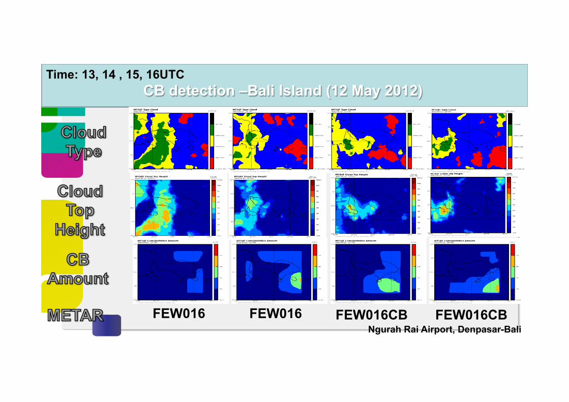
CB detection –Bali Island (12 May 2012) Time: 13, 14 , 15, 16UTC
FEW016 FEW016 FEW016CB FEW016CB Ngurah Rai Airport, Denpasar-Bali

Validation with METAR
FA
Cb exist No Cb exist
FC
FB FD
Cb exist
No Cb exist
Metar
Det
ectio
n
POD = FA / (FA+FC)
FAR = FB / (FA+FB)
N = 24 METAR Y N
DetecDon Y 5 5 N 0 14
POD = 50%
FAR = 0%

Conclusion • Geostationary satellites such as MTSAT can be used to observe
volcanic ash with high temporal resolution that is useful for aviation weather services in our region.
• Potential heavy rainfall product from satellite data provide gap-filling information to BMKG’s forecasters at regions where lack of radar observation found. In line with this, we are now engaged of combining radar data to provide alert system of significant weather events to forecasters à next generation of Himawari 8/9 is expected to be able to enhance forecasting accuracy with its higher temporal and spatial resolution data
• Satellite-derived Cb-detection using threshold and split windows technique is useful to support surface-based observation and forecasting of Cb existence for aviation stakeholders

Future challenges for BMKG • False alarms of volcanic-ash detection using MTSAT – need
further improvement of algorithm. • Need improvement in the accuracy of potential heavy rainfall
detection with validation using near real-time observation data (e.g. Radar rainfall estimate, GSMaP products).
• More satellite-derived products for aviation weather services (e.g. Turbulence, icing, wind-shear potential region) as one of BMKG’s prioriy to be developed in the near future.