151 - Texas Department of Transportation · 2015-04-27 · May 31, 1971 151 Minutes of the Seven...
45
May 3 1 , 1971 151 Minutes of the Seven Hundred and Seventeenth Meeting, a Regular Meeting of the State Highway Commission held in Austin, Texas, with the following members present: Dewitt C. Greer H. C. Petry, Jr. Charles E. Simons J. C. Dingwall Chairman Member Member State Highway Engineer 64883 IT IS ORDERED that a Regular Meeting oi the State Highway Com- mission be opened at 9:00 A. M., May 31, 1971. May 3 1 , 1971 64884 An appropriation of $39,495,572. 00 is hereby made covering construction and right of way for the following listed projects which have been previously authorized. COUNTY DIST. P.D. PROTECT NO. HIGHWAY OR LOCATION FUNDS Travis 14 M-14-K-14 Austin (Suppl. to $ Min. 64023) 29,700.00 Dallas 18 3005 RW 8018-1-27 ST 66 (Suppl. to Min. 62711) 45,000.00 Wichita 3 3260 RW 8003-1-22 US 82 (Suppl. to Min. 61388) 500,000.00 Gregg 10 3180 RW 8010-1-10 ST 149 (Suppl. to Min. 54256) 30,000.00 La Salle 15 7510 Acct. 9015-5-33 IH 35 (Suppl. to Min. 57229) 46,000.00 Comanche 23 8461 S 2388(2)A FM 2486 (Suppl. to Min. 63542) 5,903.00 Hopkins 1 8465 S 3164(1)A FM 3134 (Suppl. to Min. 64192) 14,000.00 Wheeler 25 9003 I 40-2(10) IH 40 (Suppl. to Min. 64564) 6,496.00 Falls 9 2017 A 819-2-5, etc. FM 431 (Suppl. to Min. 63342) 10,300.00 Hale 5 0130 C 67-9-15, etc. LO 445 (Suppl. to Min. 62810) 6,100.00 Galveston 12 0051 C 51-3-29 ST 3 (Suppl. to Min. 61066) 2,000.00 Lamar 1 0044 C 136-7-30, etc. US 271 (Suppl. to Min. 62071) 93,000.00 Gillespie, etc. 14 8015 F 127(6), etc. US 290 (Suppl. to Min. 64107) 5,235.00 Wichita 3 5246 M 2323-1-6 FM 2384 22,200.00 Wilbarger 3 5247 M 2312-2-4 FM 925 26,100.00 Coryell 9 5276 M 567-2-9 FM 185 63,000.00 Bell 9 5277 M 231-16-17 FM 436 4,700.00 (Continued on next page)
Transcript of 151 - Texas Department of Transportation · 2015-04-27 · May 31, 1971 151 Minutes of the Seven...

May 3 1 , 1971
151
Minutes of the Seven Hundred and Seventeenth Meet ing, a Regular Meeting of the State Highway Commission held in Aust in , Texas, w i t h the fo l lowing members present:
Dewit t C. Greer H . C. Petry, Jr. Charles E. Simons J. C. Dingwal l
Chairman Member Member State Highway Engineer
64883 IT IS ORDERED that a Regular Meeting o i the State Highway Commission be opened at 9:00 A. M . , May 3 1 , 1971.
May 3 1 , 1971
64884 An appropriation of $39,495,572. 00 is hereby made covering construction and right of way for the fo l lowing l i s ted projects which have been previously authorized.
COUNTY DIST. P . D . PROTECT NO. HIGHWAY OR LOCATION FUNDS
Travis 14 M-14-K-14 Austin (Suppl. to $ M i n . 64023)
29,700.00
Dallas 18 3005 RW 8018-1-27 ST 66 (Suppl. to M i n . 62711)
45,000.00
Wichi ta 3 3260 RW 8003-1-22 US 82 (Suppl. to M i n . 61388)
500,000.00
Gregg 10 3180 RW 8010-1-10 ST 149 (Suppl. to M i n . 54256)
30,000.00
La Salle 15 7510 Acct . 9015-5-33 IH 35 (Suppl. to M i n . 57229)
46,000.00
Comanche 23 8461 S 2388(2)A FM 2486 (Suppl. to M i n . 63542)
5,903.00
Hopkins 1 8465 S 3164(1)A FM 3134 (Suppl. to M i n . 64192)
14,000.00
Wheeler 25 9003 I 40-2(10) IH 40 (Suppl. to M i n . 64564)
6,496.00
Falls 9 2017 A 819-2-5, e tc .
FM 431 (Suppl. to M i n . 63342)
10,300.00
Hale 5 0130 C 67-9-15, e tc .
LO 445 (Suppl. to M i n . 62810)
6,100.00
Galveston 12 0051 C 51-3-29 ST 3 (Suppl. to M i n . 61066)
2,000.00
Lamar 1 0044 C 136-7-30, etc .
US 271 (Suppl. to M i n . 62071)
93,000.00
Gi l l e sp ie , e tc .
14 8015 F 127(6), e tc .
US 290 (Suppl. to M i n . 64107)
5,235.00
Wichi ta 3 5246 M 2323-1-6 FM 2384 22,200.00
Wilbarger 3 5247 M 2312-2-4 FM 925 26,100.00
Coryell 9 5276 M 567-2-9 FM 185 63,000.00
Bell 9 5277 M 231-16-17 FM 436 4 ,700.00
(Continued on next page)
152
May 3 1 , 1971
64884 Con inued -
COUNTY DIST. P . D . PROTECT NO. HIGHWAY OR LOCATION FUNDS
Hardin 20 5288 M 1947-1-5 FM 1293 $ 33,500.00
El Paso 24 T 9008(1) El Paso (Suppl. to M i n . 62605)
10,000.00
Bowie 19 T 9020(1) Texarkana (Suppl. to M i n . 62605)
12,000.00
Tarrant 2 9956 T 9009(3) TS 15 220,000.00
H i l l 9 5278 M 2547-1-3 FM 1713 9,800.00
Wil l iamson 14 5281 M 683-1-9 FM 620 16,000.00
Kimble 7 8012 F 1008(7) US 290 (Suppl. to M i n . 64107)
6,500.00
Panola 19 5281 M 394-3-10 FM 699 57,800.00
Bowie 19 5280 M 2048-1-7 FM 2253 31,500.00
Cameron 21 3724 RWA 3304-1-2 FM 3195 1,000.00
Rains 1 3720 RW 770-1-7 FM 47 6,600.00
Dimmit 22 8325 RS 364(3) FM 133 998,745.00
Sterling 7 8462 S 691(6) ST 158 124,345.00
Panola 19 8465 S 2366 (4)A FM 2517 214,505.00
Ti tus , e tc .
19 2024 A 1816-1-1 , e tc .
FM 1896 259,015.00
Wi l l acy 21 0262 C 433-5-10 FM 497 165,010.00
Gray 4 0295 C 169-10-9 FM 282 193,690.00
El l i s 18 0368 C 261-1-21 US 67 99,085.00
Gonzales, e tc .
13 9025, e tc .
I 10-6(28) IH 10 70,222.00
Hardin 20 0244 C 1096-1-20 FM 770 33,155.00
Dimmit , e tc .
22 0087, e tc .
C 37-6-39, etc .
US 83, e tc . 73,995.00
Dallam, e tc .
4 0296, e tc .
C 2724-1-3, e tc .
FM 2535, e tc . 601,515.00
Cherokee 10 0134 C 345-4-11 ST 110 342,230.00
Calhoun 13 0239 C 144-3-16 US 87 626,145.00
Dallas 18 0369 C 9-11-72 IH 30 286,735.00
Brazoria 12 0204 C 1004-1-22 FM 521 363,070.00
Frio 15 9089, e tc .
I 35-2(99), e tc .
IH 35 8,581,305.00
Travis 14 0205, e t c .
C 1378-1-9, e tc .
FM 1431 244,135.00
(Continued on next page)
64884 Con Inued —
153
May 31, 1971
COUNTY DIST. P . D . PROJECT NO. HIGHWAY OR LOCATION FUNDS
Gray, e tc .
25 2004, e tc .
A 7 9 7 - 5 - 1 , e tc .
FM 3143 $ 548,315.00
Bell 9 8013 F 1009(12) US 190 3,857,815.00
Gregg 10 0135 C 1763-2-7 FM 1845 78,970.00
Jefferson 20 0245 C 307-1-93 ST 87 226,005.00
Freestone, e tc .
17 9022, e tc .
I 45-2(7) IH 45 138,140.00
Bastrop, e tc .
14 0207, e tc .
C 114-5-21 , etc.
US 290, etc . 131,800.00
Harrison 19 0141 C 495-10-15 IH 20 271,490.00
Nacogdoches
11 0164, e tc .
C 118-8-34, e tc .
ST 2 1 , e tc . 102,860.00
Wheeler 25 0105, e tc .
C 489 -1 -11 , e tc .
ST 48, e tc . 672,980.00
Kerr, e tc .
15 0170, e tc .
C 142-2-13, etc .
ST 27 353,140.00
Upshur 19 8013, e tc .
F 109(16), etc .
US 80 1,298,645.00
Rusk 10 0136 C 1608-2-4 FM 1639 283,990.00
Brazoria 12 0205, e tc .
C 111-8-59, etc.
ST 288, etc . 449,605.00
Dal las , e tc .
18 0371, etc.
C 9-11-73, etc .
IH 30, e tc . 671,225.00
Pecos 6 8465, e tc .
SU 1058(8), e tc .
US 285 618,530.00
Freestone 17 8474 S 3209(1)A FM 2628 128,460.00
Reeves 6 9061, e tc .
I 20-1(7 9), etc.
IH 20 5,351,025.00
Hansford 4 0339 C 1886-1-6 FM 2018 191,165.00
Gray 4 8481 S 2184(3) ST 7 0 660,400.00
Freestone 17 0308 C 1326-2-8 FM 1365 58,270.00
Kaufman 18 0378, e tc .
C 197-4-37, e tc .
US 175, e tc . 206,600.00
Navarro 18 0375, etc.
C 92-6-62, e tc .
US 75, e tc . 189,735.00
Gonzales 13 9027, etc .
I 10-6(49) IH 10 3,933,210.00
Sabine, e tc .
11 0167, e tc .
C 119-6-6, e tc .
SP 35, e tc . 367,040.00
Angelina 11 0204, e tc .
C 176-2-51 , etc .
US 59, e tc . 458,640.00
(Continued on next page)
154
May 3 1 , 1971
64884 Con inued -
COUNTY DIST. P . D . PROJECT NO. HIGHWAY OR LOCATION FUNDS
Col l in 18 0380, e tc .
C 91-4-28, etc .
ST 289, etc . $ 266,415.OC
Kaufman, e tc .
18 0384, e tc .
C 95-4-32, etc .
US 80, e tc . 341,275.0C
Refugio 16 0345 MC 371-3-55 US 77 23,500.00
Young 3 3004 RW 8003-1-29 ST 24 1,000.00
Hunt 1 3003 RW 8001-1-18 SP 178 30,000.00
M i l l s 23 3006 RW 8023-1-43 US 84 80,000.00
Bexar 15 5318 M 143-1-28 US 87 6,125.00
Travis 14 7001 Acct . 9014-5-16 IH 35 (Suppl. to M i n . 63178)
2,334,000.00
Cass 19 5089 M 1131-2-4 PR 42 30, 000.00
Nueces 16 M-16-N-12 Corpus Chr is t i 6,300.00
Tyler 20 M-20-X-10 Woodville 4 ,000.00
Kendall 15 3738 RWA 3212-3-3 FM 3160 1,000.00
Anderson 10 3023 RW 8010-1-77 US 287 81,000.00
Carson 4 3700 RW 788-5-1 FM 1059 2,000.00
Fayette 13 5276 M 266-1-35 ST 71 11,000.00
Oldham, e tc .
4 9036 I 40-1(11) IH 40 (Suppl. to M i n . 64361)
2,986.00
Harr is , e tc .
12 0177, e tc .
C 28-1-46, etc .
US 90, e tc . (Suppl. to M i n . 64564)
4 ,000.00
Young 3 1707 RR 134-2-26 ST 24 15,700.00
Lubbock 5 1726 RR 3273-1-2 FM 3020 14,100.00
Blanco 14 5253 M 954-4-6 FM 1320 (Suppl. to M i n . 64275)
354.00
Burnet 14 5248 M 1378-4-14 FM 1431 (Suppl. to M i n . 64192)
1,300.00
Coleman 23 8007 F 194(16), e tc .
US 84 (Suppl. to M i n . 63342)
29,042.00
El Paso 24 0061 C 1-4-43, etc .
LO 16, e tc . (Suppl. to M i n . 63916)
4 ,350.00
Victor ia , e tc .
13 4807, e tc .
ER 26(13) US 59, e tc . 45,652.00
De W i t t , e tc .
13 4810, e tc .
ER 26(14) ST 7 2, e tc . 51,278.00
Val Verde 22 2800 TR 160-8-1 RR 2 (Suppl. to M i n . 64275)
4 ,800.00
Brazos 17 0059 C 49-9-30, e tc .
ST 6 (Suppl. to M i n . 61292)
121,844.00
(Continued on next page)

155
May 3 1 , 1971
64884 Con inued -
COUNTY DIST. P . D . PROTECT NO. HIGHWAY OR LOCATION FUNDS
Duval 21 3725 RWA 3305-1-1 FM 3196 $ 200.00
Bell 9 7001 Acct . 9009-5-26 IH 35 (Suppl. to M i n . 56570)
5,000.00
Matagorda 12 3718 RWA 2697-1-6 FM 2668 (Suppl. to M i n . 62605)
1,000.00
Scurry 8 1711 RR 966-1-5 FM 644 10,300.00
Navarro 18 0205 C 574-1-14 ST 309 (Suppl. to M i n . 62711)
17,500.00
Cameron 21 T 9048(1) Brownsville 15,000.00
Van Zandt 10 0079 C 443-3-5 FM 17 (Suppl. to M i n . 62496)
17, 670. 00
Midland 6 0138 C 5-2-48, US 8 1 , etc . (Suppl. e tc . to M i n . 63129)
2,000.00
Oldham, e tc .
4 9032 I 40-1(79) IH 40 (Suppl. to M i n . 63342)
07,390.00
Refugio 16 5055 M 371-3-57 US 77 7,100.00
TOTAL $ 39,495,572. 00
64885 WHEREAS, in the fo l lowing counties, engineering and t r a f f i c investigations have been made to determine the reasonable and safe prima facie maximum speeds on the sections of
' COUNTY DIST. DESCRIPTION ZONE SPEED
TARRANT 2 FARM TO MARKET ROAD 157 from Station 40 1291+69.7, Control 747-4, F 385(38), southerly to Station 1310+95.0, Control 747-4, F 385(38), a distance of 0.365 mile approximately,
WISE 2 FARM TO MARKET ROAD 1658 from Station 40 203+00, Control 1606-1, C 1606-1-9, southerly to Station 227+00, Control 1606-1, C 1606-1-9, a distance of 0.455 mile approximately,
ARMSTRONG 4 U . S. HIGHWAY 287 from the East Ci ty 45 Limit of Claude at Station 881+56, Cont ro l 42-4 , C 42-4-25, easterly to Station 893+00, Control 42-4, C 42-4-25, a distance of 0.210 mile approximately,
CHEROKEE 10 FARM TO MARKET ROAD 13 from Station 50 & SMITH 31+30, Control 5 9 1 - 1 , C 591-1-3 in
Smith County, southeasterly to Station 464+33, Control 591-3, C 591-3-5 in Cherokee County, a distance of 8.202 miles approximately,
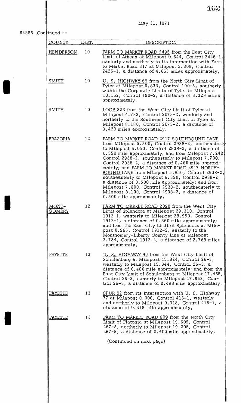
HENDERSON 10 FARM TO MARKET ROAD 90 from Station 45 260+47.4, Control 646-5, C 646-5-8, southerly to Station 296+84, Control 646-5, C 646-5-8, a distance of 0.689 mile approximately; and from Station
(Continued on next page)
64885 Con
May 3 1 , 1971
156
inued —
COUNTY DIST. DESCRIPTION ZONE SPEED
360+00, Control 646-5, C 646-5-8, southerly to Station 433+91, Control 646-5, C 646-5-8, a distance o i 1.352 miles approximately,
HENDERSON 10 FARM TO MARKET ROAD 3062 from Station 45 445+32, Control 3193-1 , S 3205 (1)A, easterly to Station 5 07+00, Control 3193-1 , S 3205(1)A, a distance of 1.168 miles approximately,
POLK 11 U . S. HIGHWAY 59 from Station 45 1206+82, Control 176-4, C 176-4-37, northerly to Station 1650+34.47, Cont ro l 17 6-4, C 17 6-4-37, a distance of 8.400 miles approximately,
BRAZORIA 12 STATE HIGHWAY 6 from Station 45 142+48.45, Control 192-2, F 318(10), westerly to Station 17 2+48.45, Control 192-2, F 318(10), a distance o i 0.568 mile approximately,
BRAZORIA 12 STATE HIGHWAY 35 from the Southwest 35 Ci ty Limit of Alv in at Station 92+65, Control 178-3, C 178-3-67, southwesterly to the Northeast Ci ty Limit of Angleton at Station 1031+57.6, Control 178-3, C 178-3-67, a distance o i 17.782 miles approximately,
BRAZORIA 12 STATE HIGHWAY 288 from the Northwest 35 Ci ty Limit of Freeport at Station 103+24. 04, Control 111-8, C 111-8-34, northwesterly to the Southeast Ci ty Limit of Lake Barbara at Station 181+62.3, Control 111-8, C 111-8-34, a distance of 1.254 miles approximately; from the Northwest Ci ty Limit of Richwood at Station 342+50.3, Control 111-8, C 111-8-34, northwesterly to the Southeast Ci ty Limit o i Angleton at Station 759+60.52, Control 111-7, C 111-7-19, a distance of 7.877 miles approximately; and from the North Ci ty Limit of Angleton at Station 59+20.5, Control 111-9, C 111-9-16, northerly to the Fort Bend County Line at Station 922+63.5, Control 111-4, C 111-4-21 , a distance of 10.154 miles approximately,
HARRIS & 12 INTERSTATE HIGHWAY 45 from Station 45 MONTGOMERY 432+55.75, Control 110-6-41 ,
I 45-1(122)000, northerly to Station 902+00, Control 110-4-62, I 45-1(122)060, a distance o i 23. 984 miles approximately,
FAYETTE 13 STATE HIGHWAY 71 from Station 5+68, 45 Control 266-1 , F 417(14), w i t h i n the Corporate Limits of La Grange, easterly w i t h i n and without the Corporate Limits of La Grange to Station 84+00, Control 2 6 6 - 1 , F 417(14), a distance of 1.483 miles approximately,
(Continued on next page)

64885 Con inued —
I
I
I
157
May 3 1 , 1971
COUNTY DIST. DESCRIPTION ZONE SPEEE
BEXAR 15
BEXAR 15
COMAL 15
COMAL 15
COMAL 15
LIVE OAK 16
NUECES 16
REFUGIO 16
SAN PATRICIO 16
SAN PATRICIO 16
INTERSTATE HIGHWAY 35 from Station 45 24+23.99, Control 17-3, 1 35-2(98)134, northeasterly through Von Ormy (unincorporated) to the Southwest Ci ty Limits o i San Antonio at Station 472+22.51, Control 17-2, I 35-2(98)134, a distance of 8.47 miles approximately,
FARM TO MARKET ROAD 25 36 irom Station 3 0 245+00, Control 2440-1 , C 2440-1-5, southerly to Station 268+00, Control 2440-1 , C 2440-1-5, a distance of 0.435 mile approximately,
STATE HIGHWAY 46 from Station 85 0+00, 40 Control 215-1 , A 3213-1-2, westerly to Station 864+00, Control 2 1 5 - 1 , A 3213-1-2, a distance of 0.265 mile approximately,
FARM TO MARKET ROAD 311 from Station 30 56+00.0, Control 1541-1, A 3213-1-2, northerly to Station 76+00, Control 1541-1, A 3213-1-2, a distance of 0.379 mile approximately,
FARM TO MARKET ROAD 2673 from Station 40 390+00.0, Control 2650-1 , A 3213-1-2, westerly to Station 404+00.0, Control 2650-1 , A 3213-1-2, a distance o i 0.265 mile approximately,
INTERSTATE HIGHWAY 37 from Station 45 419+50, Control 74-2-27, I 37-1(18)047, northerly to Station 562+69, Control 74-2-27, I 37-1(18)047, a distance o i 2.713 miles approximately,
PARK ROAD 22 from Station 259+67. 20, 45 Control 517-2, S 3027(5), southerly to Station 457+95. 22, Control 617-2, S 3027(5), a distance of 3.755 miles approximately,
FARM TO MARKET ROAD 774 from its 45 junct ion w i t h State Highway 35 at Stat ion 1+10, Control 447-5, C 447-5-29, northeasterly to Station 24+89, Control 447-5, C 447-5-29, a distance o i 7.465 miles approximately,
U . S. HIGHWAY 77 from the South City 45 Limit of Sinton at Station 588+29.2, Control 3 7 2 - 1 , C 372-1-27, southerly to Station 527+05.3, Control 3 7 2 - 1 , C 372-1-27, a distance of 1.100 miles approximately,
U . S . HIGHWAY 181 from the East Ci ty 45 Limit of Sinton at Station 461+53.69, Control 101-3, C 101-3-29, easterly to Station 566+75, Control 101-3, C 101-3-29, a distance of 1.992 miles approximately,
(Continued on next page)

I
I
I
158
May 3 1 , 1971
inued —
COUNTY DIST. DESCRIPTION ZONE SPEEE
WALKER 17 U . S. HIGHWAY 190 from Station 45 330+00, Control 213 -1 , C 213-1-16, easterly to Station 37 2+00, Control 213 -1 , C 213-1-16, a distance of 0.795 mile approximately,
COLLIN 18 STATE HIGHWAY 24 from Station 0+20, 30 Control 135-5, C 135-5-16, westerly to Station 160+62, Control 135-5, C 135-5-16, a distance of 3.038 miles approximately,
COLLIN 18 FARM TO MARKET ROAD 1777 irom Station 30 82+50, Control 1014-4, C 1014-4-6, northerly to Station 302+67, Control 1014-4, C 1014-4-6, a distance of 4.169 miles approximately,
DENTON 18 FARM TO MARKET ROAD 428 irom Station 30 195+00, Control 81-5, S 1118(3), northerly to Station 234+00, Control 81-5, S 1118(3), a distance of 0.725 mile approximately,
DENTON 18 FARM TO MARKET ROAD 428 from Station 40 234+00, Control 81-5, C 8 1 - 5 - 2 1 , easterly to Station 395+61. 2, Control 81-5, C 8 1 - 5 - 2 1 , a distance of 3.061 miles approximately,
ELLIS 18 INTERSTATE HIGHWAY 45 from Station 40 307+72, Control 92-5, C 92-5-27, southeasterly to Station 0+00, Cont ro l 92-5, C 92-5-27, a distance of 5.798 miles approximately,
ELLIS 18 U . S. HIGHWAY 67 from Station 191+00, 40 Control 260-2, C 260-2-19, northeasterly to Station 279+48.2, Control 260-2, C 260-2-19, a distance o i 1.675 miles approximately,
ELLIS 18 LOOP 489 from Station 308+50, Control 40 260-4, C 260 -4 -1 , northeasterly to Station 276+22, Control 260-4, C 2 6 0 - 4 - 1 , a distance of 0.611 mile approximately,
JASPER 20 FARM TO MARKET ROAD 777 from Station 40 52+00, Control 1109-1, C 1109-1-11, southerly to Station 5+00, Control 1109-1, C 1109-1-11, a distance of 0.573 mile approximately,
WILLACY 21 LOOP 448 from Station 666+13.5, Con 45 t ro l 327-6, C 2119-1-5, northerly to Station 667+23.5, Control 327-6, C 2119-1-5, a distance o i 0.02 mile approximately,
WILLACY 21 FARM TO MARKET ROAD 2209 from Station 45 52+58, Control 2119-1 , C 2119-1-5, southerly to Station 53+58, Control 2119-1 , C 2119-1-5, a distance of 0.019 mile approximately,
(Continued on next page)
159
64885 Con::
I
I
64886
I
May 31, 1971
nued —
COUNTY DIST. DESCRIPTION ZONE SPEEE
KINNEY 22
UVALDE 22
VAL VERDE 22
U. S. HIGHWAY 90 from the Val Verde- 40 Kinney County Line at Station 0+00, Control 23-2, C 23-2-27, easterly to the City Limit of Brackettville at Station 911+48.5, Control 23-3, C 23-3-24, a distance oi 17.262 miles approximately,
FARM TO MARKET ROAD 187 from Station 40 461+00, Control 678-1, C 678-1-13, northerly to Station 593+00, Control 678-1, C 678-1-13, a distance o i 2.500 miles approximately,
U . S. HIGHWAY 277 irom Station 0+00, 40 Control 160-4, C 160-4-12, northerly to the Val Verde-Edwards County Line at Station 619+81.92, Control 160-4, C 160-4-12, a distance oi 11.739 miles approximately,
where construction projects are in progress; and
WHEREAS, it has been determined by these engineering and traffic investigations that the reasonable and safe prima facie maximum speeds on the sections of highways described herein are as tabulated under the heading, "Zone Speed".
NOW, THEREFORE, THE STATE HIGHWAY COMMISSION hereby declares and iixes the reasonable and safe prima facie maximum speed limits on the sections o i highways described herein to be as tabulated under the heading, "Zone Speed", and i t is ordered that the State Highway Engineer be authorized to proceed with the erection o i appropriate signs showing the maximum speed limits as tabulated under the heading, "Zone Speed". Upon completion o i each construction project, al l such signs applying to that project shall be removed. The completion and/or acceptance of each project shall cancel the provision of this Minute applying to said project.
WHEREAS, in the following counties, engineering and traffic investigations have been made to determine the reasonable and safe prima facie maximum speeds on the sections of
COUNTY DIST. DESCRIPTION
GRAYSON
TOHNSON
FARM TO MARKET ROAD 1417 from its intersection of Farm to Market Road 120 at Milepost 4.000, Control 2456-1, southerly and easterly to the West City Limit of Sherman at Milepost 17.100, Control 2455-1, a distance of 13.100 miles approx mately,
STATE HIGHWAY 174 from the South City Limit of Joshua at Station 327+91, Control 19-01, southerly to Station 310+00, Control 19-01, a distance of 0.339 mile approximately,
WISE FARM TO MARKET ROAD 730 from the North City Limit of Decatur at Station 79+04, Control 2292-northerly to Station 672+43, Control 2292-01, a distance oi 11.272 miles approximately,
(Continued on next page)
01
64886 Con inued —
I
I
I
160
May 31, 1971
COUNTY DIST. DESCRIPTION
WISE
WISE
WISE
GRAY
DAWSON
DAWSON
DAWSON
DAWSON & LYNN
LUBBOCK
LYNN
LYNN
FARM TO MARKET ROAD 2127 from Station 0+00, Control 1848-02, northerly and westerly through Crafton (unincorporated) to the Wise-Jack County Line at Station 178+30, Control 1848-02, a distance of 6.110 miles approximately,
FARM TO MARKET ROAD 2265 from its intersection with Farm to Market Road 2127 at Station 0+00, Control 2738-01, easterly to its intersection with Farm to Market Road 1655 at Station 266+46.7, Control 2738-01, a distance of 8.956 miles approximately,
FARM TO MARKET ROAD 295 2 from its intersection with Farm to Market Road 1810 at Station 0+00, Control 3011-01, southerly to its intersection with Farm to Market Road 1658 at Station 325+66, Control 3011-01, a distance of O. 270 miles approximately,
U . S. HIGHWAY 60 from the West City Limit of Pampa at Station 366+34.8, Control 169-6, westerly to Station 318+60, Control 169-6, a distance of 0.904 mile approximately; and from the East City Limit of Pampa at Station 85+30, Control 169-7, easterly to Station 137+68, Control 169-7, a distance oi 0.992 mile approximately,
U . S. HIGHWAY 180 from Station 380+40, Control 295-1, easterly through Key (unincorporated) to Station 401+58, Control 295-1, a distance of 0.400 mile approximately,
FARM TO MARKET ROAD 178 from Station 661+22.2, Control 959-2, southerly through Key (unincorporated) to Station 142+31.3, Control 959-1, a distance of 0.7 00 mile approximately,
FARM TO MARKET ROAD 178 from Station 21+12, Control 959-1, southerly through Midway (unincorporated) to Station 196+06, Control 959-1, a distance of 0.800 mile approximately,
FARM TO MARKET ROAD 205 3 irom Station 29+79.8, Control 1966-1, in Dawson County, northerly and easterly to Station 7 6+22, Control 1966-2, in Lynn County, a distance of 0.800 mile approximately,
FARM TO MARKET ROAD 40 irom the East City Limit oi Lubbock at Station 54+03, Control 644-1, easterly to Station 165+5 0, Control 644-1, a distance oi 2.113 miles approximately,
FARM TO MARKET ROAD 2053 from Station 349+43, Control 1966-2, easterly and northerly to Station 439+13.03, Control 1966-2, a distance of 1.701 miles approximately,
FARM TO MARKET ROAD 2053 from its intersection with U . S. Highway 87 West Service Road at Station 656+90, Control 1966-2, westerly to Station 611+25, Control 1966-2, a distance o i 0.865 mile approximately; and from its intersection with U . S. Highway 87 East Service Road at Station 0+00, Con trol 1966-3, easterly to Station 31+68, Control 1966-3, a distance of 0.600 mile approximately,
(Continued on next page)
54886 Con
161
May 61, 1971
inued —
OOUNTY OlST. DESCRIPTION
TYNN 5 EARMTOMARKETROAD6112 irom its intersection with Earmto Market Road 2056 at Station 687+17. 1, Control 0167-1, northerly to Station 668+59.1, Control6167-l , adistance ei 0.650 miie approximateiy.
TONES 8 H. S.HiOHWAY 680 irom the Southeast City Timit oiStamiord at Station 706+50, Cont ro i l07-1 , southeasterly to Station 695+94, Control 107-1, a distance oiO.200 miie approximateiy.
TONES 8 H.S .HiOHWAY 680 irom theWest City T imi to i TuedersatStation 66+07, Oontroi 107-1, westerly to Station 66+92, Control 107-1, a distance oi 0.076 miie approximateiy; and iromtheEast City TimitoiTueders at Station 9+87, Con t ro i l07-1 , easterly to Station2+69, Oontroi 107-1, adlstanoe oi 0.142 miie approximateiy.
MiTCHETT 8 INTERSTATE H1OHWAY20 MAIN TANES irom the West Oity TimitoiToraine at Station 1564+44.6, Oontroi 6 -1 , easterlywithinthe Corporate Timits oiToraine tothe East Oity TimitoiToraine at Station 1590+57.4, Oontroi 6 -1 , adlstanoe o i 1.066 miles approximateiy.
MITCHETT 8 INTERSTATE HiOHWAY 20 MAIN TANES irom the West Oity TimitoiOoiorado Oity at Station 992+91.5, Oontroi 5-8, easterly through the OorporateTimits oiColorado O i ty to theEas tO i ty T imi to i Colorado Oity at Station 1116+96.61, Control5-8, adlstanoe o i 2.649 miies approximately.
NOTAN 8 INTERSTATE HiOHWAY 20 MAIN TANES irom the West City T imi to i Sweetwater at Station 808+98.6, Control 6-2, easterlywithinthe Corporate Timits o Sweetwater totheEast Ci tyTimitoiSweetwaterat Station 910+24. 04, Control 6-6, adlstanoe oi 1.917 miles approximateiy,
RETT 9 STATE HIOHWAY 95 irom the North City T imi to i Holland at Station 666+75, Control 620-2, southwesterly withinthe Corporate Timits o iHoi iandto Station 695+75.4, Control 620-2, adlstanoe oi 0.626mile approximately; andiromtheSouthCity T imi to i Holland at Station 749+56, Control 620-2, southwesterlyto Station 770+68, Control 620-2, a distance oiO.400 miie approximately,
MoTENNAN 6 SRHR 299 irom the East City T imi to i Waco at Station 60+97, Control 162-1, easterly to the West Ci tyTimitoiOel imeadatStat ion 45+66, Controi 162-1, a distance oiO.278 miieapproxi-mately.
HENDERSON 10 EARM TO MARKET ROAD1616 irom the North City TimitoiAthens at Milepost 0.650, Controll099-6, northerly tothe SouthCi tyTimi to iMurchisonat Milepost 6.660, Control 1099-6, adistance o i 6.280 miles approximateiy.
(Continuedonnextpage)
64886 Con
I
I
I
May 31, 1971
inued
COUNTY DIST. DESCRIPTION
HENDERSON 10
SMITH 10
SMITH 10
BRAZORIA 12
MONT- 12 GOMERY
FAYETTE 13
FAYETTE 13
FAYETTE 13
FARM TO MARKET ROAD 2495 from the East City Limit of Athens at Milepost 0.644, Control 2426-1, easterly and northerly to its intersection with Farm to Market Road 317 at Milepost 5. 309, Control 2426-1, a distance of 4.665 miles approximately,
U . S. HIGHWAY 69 from the North City Limit of Tyler at Milepost 6.833, Control 190-5, southerly within the Corporate Limits of Tyler to Milepost 10.162, Control 190-5, a distance oi 3.329 miles approximately,
LOOP 323 from the West City Limit oi Tyler at Milepost 4.733, Control 2075-2, westerly and northerly to the Southwest City Limit oi Tyler at Milepost 8.180, Control 2075-2, a distance oi 3.428 miles approximately,
FARM TO MARKET ROAD 2917 SOUTHBOUND LANE from Milepost 5.5 00, Control 2938-2, southeaster! to Milepost 6.050, Control 2938-2, a distance oi 0.550 mile approximately; and from Milepost 7.240 Control 2938-2, southeasterly to Milepost 7.7 00, Control 2938-2, a distance oi 0.460 mile approximately; and FARM TO MARKET ROAD 2917 NORTHBOUND LANE from Milepost 5.850, Control 2938-2, southeasterly to Milepost 6.350, Control 2938-2, a distance of 0.500 mile approximately; and from Milepost 7.600, Control 2938-2, southeasterly to Milepost 8.100, Control 2938-2, a distance of 0.500 mile approximately,
FARM TO MARKET ROAD 2090 from the West City Limit oi Splendora at Milepost 29.310, Control 1912-1, westerly to Milepost 28.950, Control 1912-1, a distance oi 0.360 mile approximately; and from the East City Limit of Splendora at M i l e post 0.965, Control 1912-2, easterly to the Montgomery-Liberty County Line at Milepost 3.734, Control 1912-2, a distance of 2.769 miles approximately,
U. S. HIGHWAY 90 from the West City Limit of Schulenburg at Milepost 15.824, Control 26-3, westerly to Milepost 15.344, Control 26-3, a distance of 0.480 mile approximately; and irom the East City Limit oi Schulenburg at Milepost 17.465, Control 26-3, easterly to Milepost 17.953, Control 26-3, a distance of 0.488 mile approximately,
SPUR 92 from its intersection with U . S. Highway 77 at Milepost 0. 000, Control 416-1, westerly and northerly to Milepost 0.318, Control 416-1, a distance of 0.318 mile approximately,
FARM TO MARKET ROAD 609 from the North City Limit of Flatonia at Milepost 19. 605, Control 267-5, northerly to Milepost 19.205, Control 267-5, a distance of 0.400 mile approximately,
(Continued on next page)

54000 Con
D
^
^
163
May 31,1571
Inued —
CCUNTY DIST. DESCRIPTION
HAYS 14 RANCH TC MARKET RCAD 150 from Station 0+72, Control I I 5 7 - I , southeasterly throughDrlftwood (unincorporated) toStat!on 550+00, Control I I 5 7 - I , a distance of 10.552 miles approximately; and from Station 400+00, Control 005-4, southeasterly to theWest City Elmltof Kyle at Station 415+00, ControI 005-4, adistanceof 0.250 mlleapproxl-mateIy;andfromStatton7+7I, ControI 005-I , wlthlnthe Corporate Elmlts of Kyle, easterly to the East City Elmltof Kyle at Station 10+00, Control 005-1, adistanceof 0.211 mile approximately,
HAYS 14 RANCH TC MARKET RCAD 2770 from the South City Elmlt of Ruda at Station 10+40, Control 0210-1, souther1ytoStatIon 55+00, ControI02lO-I , a d i s tance of 0.700 mIIe approximately.
TRAVIS 14 EARM TC MARKET RCAD 1025 from Station 121+74, Control I 5 0 2 - I , easterly to theWest City Elmltof Pflugerville at StatIonI45+55, Cont roI I502- I , a dlstanceof 0.527 mile approximately; andfromthe East City Elmlt of PflugeryHIe at Station 101+25, Cont roI I502- I , easterly to Station 100+52, Control I 5 0 2 - I , adistance of 0.107 mile approximately
REXAR 15 PARM TC MARKET RCADI5I0 from the Rexar-Atasco County EIne at Milepost 0.000, Control I 74 I -2 , easterly tothe West CI tyTIml tof Somerset at Mile post 0.007, Control I74 I -2 , adistance ofO.007 miles approximately; andfromthe East CItyTImIt of Somerset at Milepost 0. 055, Control I 74 I -2 , easterly to Its IntersectlonwIthStateHIghway 10 atMIIepost 5.555, Control I 74 I -2 , adistanceof 0.500 miles approximately.
REXAR 15 EARMTCMARKETRCAD2I70 from Its Intersection w l t h H . S. Highway 01 at MHepost 4.021, Control 2020-2, southerlyto theNorthCItyEImlt of Somerset at MIIepost7.020, Control 2020-2, adistance of 0. 002 miles approximately,
SAN PATRICIC
15 H. S .HICHWAYI0I from the North City Elmltof Portland at Station 500+70.50, ControI lOI-4, southerly wlthlnthe Corporate Elmlts of Portland tothe SouthCItyEImlt of Portlandat Station 505+00, Control I 0 I - 5 , adistance of 4.274 mIIes approximately,
CASS 15 PARM TCMARKETRCADI25from Its Intersection with State HIghwayOat Station 511+25, Control 52-0, southeasterly to the North CI tyTIml tof EIndenatStatIon505+00, Control 52-0, adistance of 0.541 mile approximately,
CASS 15 PARM TCMARKETRCADI04Ifrom Its Intersection wIthStateHIghway40 InRIylns (unincorporated) at Station 0+05, Control I 7 5 0 - I , easterly t o l t s Inter-sectlonwtthParmtoMarketRoad 25Ia t Station 207+41.7, Control I 7 5 0 - I , adistance of 0.511 miles approximately.
EEPASC 24 ECCP 075 from Its Intersection wlthStateHIghway 20atStatIonO+25, Control 2552-1, easterly to Station 02+00, Control 2552-1, adis tanceof 1.540 miles approximately; and from Its Intersection
(Continued on next page)
64886 Con Inued —
I
I
I
164
May 31, 1971
COUNTY DIST. DESCRIPTION
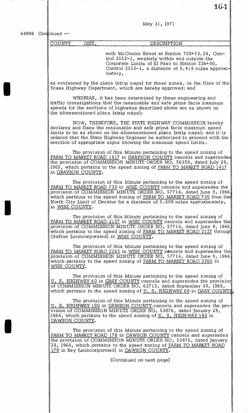
with McCombs Street at Station 705+5 3. 24, Control 2552-1, westerly within and outside the Corporate Limits of El Paso to Station 226+00, Control 2552-1, a distance oi 9.419 miles approximately,
as evidenced by the plans (strip maps) for these zones, in the files of the Texas Highway Department, which are hereby approved; and
WHEREAS, it has been determined by these engineering and traffic investigations that the reasonable and saie prima facie maximum speeds for the sections of highways described above are as shown on the aforementioned plans (strip maps);
NOW, THEREFORE, THE STATE HIGHWAY COMMISSION hereby declares and fixes the reasonable and safe prima facie maximum speed limits to be as shown on the aforementioned plans (strip maps); and i t is ordered that the State Highway Engineer be authorized to proceed with the erection of appropriate signs showing the maximum speed l imits .
The provision of this Minute pertaining to the speed zoning o i FARM TO MARKET ROAD 1417 in GRAYSON COUNTY cancels and supersedes the provision of COMMISSION MINUTE ORDER NO. 56359, dated July 29, 1965, which pertains to the speed zoning of FARM TO MARKET ROAD 1417 in GRAYSON COUNTY.
The provision of this Minute pertaining to the speed zoning o i FARM TO MARKET ROAD 730 in WISE COUNTY cancels and supersedes the provision of COMMISSION MINUTE ORDER NO. 57714, dated June 9, 1966 which pertains to the speed zoning oi FARM TO MARKET ROAD 7 30 irom the North City Limit oi Decatur ior a distance of 5.609 miles approximately, in WISE COUNTY.
The provision oi this Minute pertaining to the speed zoning o i FARM TO MARKET ROAD 2127 in WISE COUNTY cancels and supersedes the provision of COMMISSION MINUTE ORDER NO. 57714, dated June 9, 1966 which pertains to the speed zoning of FARM TO MARKET ROAD 2127 througr Crafton (unincorporated) in WISE COUNTY.
The provision of this Minute pertaining to the speed zoning oi FARM TO MARKET ROAD 2265 in WISE COUNTY cancels and supersedes the provision o i COMMISSION MINUTE ORDER NO. 57714, dated June 9, 1966 which pertains to the speed zoning of FARM TO MARKET ROAD 2265 in WISE COUNTY.
The provision oi this Minute pertaining to the speed zoning of U. S. HIGHWAY 60 in GRAY COUNTY cancels and supersedes the provisior of COMMISSION MINUTE ORDER NO. 62713, dated September 30, 1969, which pertains to the speed zoning of U . S. HIGHWAY 60 in GRAY COUNTl
The provision of this Minute pertaining to the speed zoning of U. S. HIGHWAY 180 in DAWSON COUNTY cancels and supersedes the provision of COMMISSION MINUTE ORDER NO. 53876, dated January 29, 1964, which pertains to the speed zoning o i U . S. HIGHWAY 180 in DAWSON COUNTY.
The provision o i this Minute pertaining to the speed zoning o i FARM TO MARKET ROAD 178 in DAWSON COUNTY cancels and supersedes the provision o i COMMISSION MINUTE ORDER NO. 53876, dated January 29, 1964, which pertains to the speed zoning of FARM TO MARKET ROAD 178 in Key (unincorporated) in DAWSON COUNTY.
(Continued on next page)

64886 Con inued —
I
I
I
1.
May 31, 1971
The provision of this Minute pertaining to the speed zoning of FARM TO MARKET ROAD 178 in DAWSON COUNTY cancels and supersedes the provision of COMMISSION MINUTE ORDER NO. 53876, dated January 29, 1964, which pertains to the speed zoning of FARM TO MARKET ROAD 178 through Midway (unincorporated) in DAWSON COUNTY.
The provision of this Minute pertaining to the speed zoning oi FARM TO MARKET ROAD 2053 in DAWSON and LYNN COUNTIES cancels and supersedes the provisions of COMMISSION MINUTE ORDER NO. 54028, dated February 25, 1964, which pertains to the speed zoning of FARM TO MARKET ROAD 2053 in DAWSON and LYNN COUNTIES.
The provision oi this Minute pertaining to the speed zoning of FARM TO MARKET ROAD 40 in LUBBOCK COUNTY cancels and supersedes the provision of COMMISSION MINUTE ORDER NO. 53876, dated January 29, 1964, which pertains to the speed zoning of FARM TO MARKET ROAD 40 from the East City Limit oi Lubbock ior a distance of 1.571 miles approximately, in LUBBOCK COUNTY.
The provisions oi this Minute pertaining to the speed zoning oi FARM TO MARKET ROAD 2053 in LYNN COUNTY cancels and supersedes the provisions of COMMISSION MINUTE ORDER NO. 54028, dated Februar 25, 1964, which pertains to the speed zoning of FARM TO MARKET ROAD 2053 in LYNN COUNTY.
The provision of this Minute pertaining to the speed zoning of U. S. HIGHWAY 380 in TONES COUNTY cancels and supersedes the provision of COMMISSION MINUTE ORDER NO. 53457, dated September 20, 1963, which pertains to the speed zoning of U . S. HIGHWAY 380 in TONES COUNTY.
The provision of this Minute pertaining to the speed zoning of U. S. HIGHWAY 380 in TONES COUNTY cancels and supersedes the provision of COMMISSION MINUTE ORDER NO. 53583, dated October 24, 1963, which pertains to the speed zoning of U . S. HIGHWAY 380 in TONES COUNTY.
The provision of this Minute pertaining to the speed zoning o i STATE HIGHWAY 95 in BELL COUNTY cancels and supersedes the provision of COMMISSION MINUTE ORDER NO. 53349, dated August 12, 1963, which pertains to the speed zoning of STATE HIGHWAY 95 in BELL COUNTY
The provision oi this Minute pertaining to the speed zoning of FARM TO MARKET ROAD 2090 in MONTGOMERY COUNTY cancels and super! sedes the provision o i COMMISSION MINUTE ORDER NO. 64482, dated January 29, 1971, which pertains to the speed zoning of FARM TO MARKET ROAD 2090 through Splendora in MONTGOMERY COUNTY.
The provision of this Minute pertaining to the speed zoning of U. S. HIGHWAY 90 in FAYETTE COUNTY cancels and supersedes the provision of COMMISSION MINUTE ORDER NO. 54731, dated June 22, 1964, which pertains to the speed zoning of U . S. HIGHWAY 90 in FAYETTE COUNTY.
The provision of this Minute pertaining to the speed zoning of SPUR 92 in FAYETTE COUNTY cancels and supersedes the provision of COMMISSION MINUTE ORDER NO. 54940, dated August 31, 1954, which pertains to the speed zoning oi SPUR 92 in FAYETTE COUNTY.
The provision oi this Minute pertaining to the speed zoning of FARM TO MARKET ROAD 009 in FAYETTE COUNTY cancels and supersedes the provision of COMMISSION MINUTE ORDER NO. 54271, dated May 5, 1964, which pertains to the speed zoning of FARM TO MARKET ROAD 609 in FAYETTE COUNTY.
(Continued on next page)
166
64886 Con Inued —
May 31, 1971
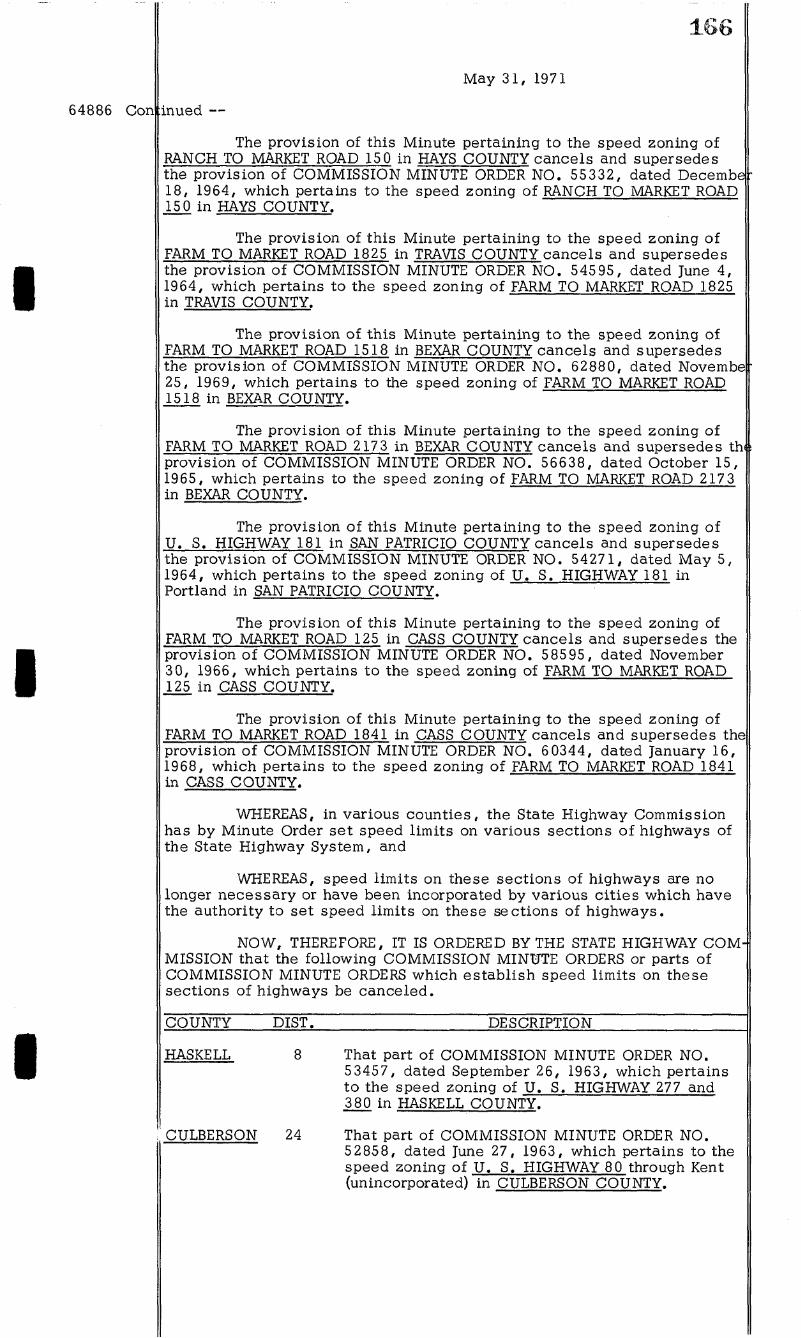
The provision oi this Minute pertaining to the speed zoning of RANCH TO MARKET ROAD 15 0 in HAYS COUNTY cancels and supersedes the provision of COMMISSION MINUTE ORDER NO. 55332, dated Decembe 18, 1964, which pertains to the speed zoning of RANCH TO MARKET ROAD 150 in HAYS COUNTY.
The provision of this Minute pertaining to the speed zoning of FARM TO MARKET ROAD 1825 in TRAVIS COUNTY cancels and supersedes the provision of COMMISSION MINUTE ORDER NO. 54595, dated June 4, 1964, which pertains to the speed zoning of FARM TO MARKET ROAD 1825 in TRAVIS COUNTY.
The provision of this Minute pertaining to the speed zoning of FARM TO MARKET ROAD 1518 in BEXAR COUNTY cancels and supersedes the provision of COMMISSION MINUTE ORDER NO. 62880, dated Novembe -25, 1969, which pertains to the speed zoning of FARM TO MARKET ROAD 1518 in BEXAR COUNTY.
The provision of this Minute pertaining to the speed zoning of FARM TO MARKET ROAD 217 3 in BEXAR COUNTY cancels and supersedes th,: provision of COMMISSION MINUTE ORDER NO. 56638, dated October 15, 1965, which pertains to the speed zoning of FARM TO MARKET ROAD 2173 in BEXAR COUNTY.
The provision o i this Minute pertaining to the speed zoning of U. S. HIGHWAY 181 in SAN PATRICIO COUNTY cancels and supersedes the provision of COMMISSION MINUTE ORDER NO. 54271, dated May 5, 1964, which pertains to the speed zoning of U . B. HIGHWAY 181 in Portland in SAN PATRICIO COUNTY.
The provision of this Minute pertaining to the speed zoning of FARM TO MARKET ROAD 125 in CASS COUNTY cancels and supersedes the provision of COMMISSION MINUTE ORDER NO. 58595, dated November 30, 1966, which pertains to the speed zoning of FARM TO MARKET ROAD 125 in CASS COUNTY.
The provision of this Minute pertaining to the speed zoning of FARM TO MARKET ROAD 1841 in CASS COUNTY cancels and supersedes the provision of COMMISSION MINUTE ORDER NO. 6 0344, dated January 16, 1968, which pertains to the speed zoning of FARM TO MARKET ROAD 1841 in CASS COUNTY.
WHEREAS, in various counties, the State Highway Commission has by Minute Order set speed limits on various sections of highways oi the State Highway System, and
WHEREAS, speed limits on these sections oi highways are no longer necessary or have been incorporated by various cities which have the authority to set speed limits on these sections of highways.
NOW, THEREFORE, IT IS ORDERED BY THE STATE HIGHWAY COM MISSION that the following COMMISSION MINUTE ORDERS or parts oi COMMISSION MINUTE ORDERS which establish speed limits on these sections of highways be canceled.
COUNTY DIST. DESCRIPTION
HASKELL
CULBERSON 24
That part of COMMISSION MINUTE ORDER NO. 53457, dated September 26, 1963, which pertains to the speed zoning oi U . S. HIGHWAY 277 and 380 in HASKELL COUNTY.
That part oi COMMISSION MINUTE ORDER NO. 52858, dated June 27, 1963, which pertains to the speed zoning of U . S. HIGHWAY 80 through Kent (unincorporated) in CULBERSON COUNTY.
I
I
I
167
May 3 1 , 1971
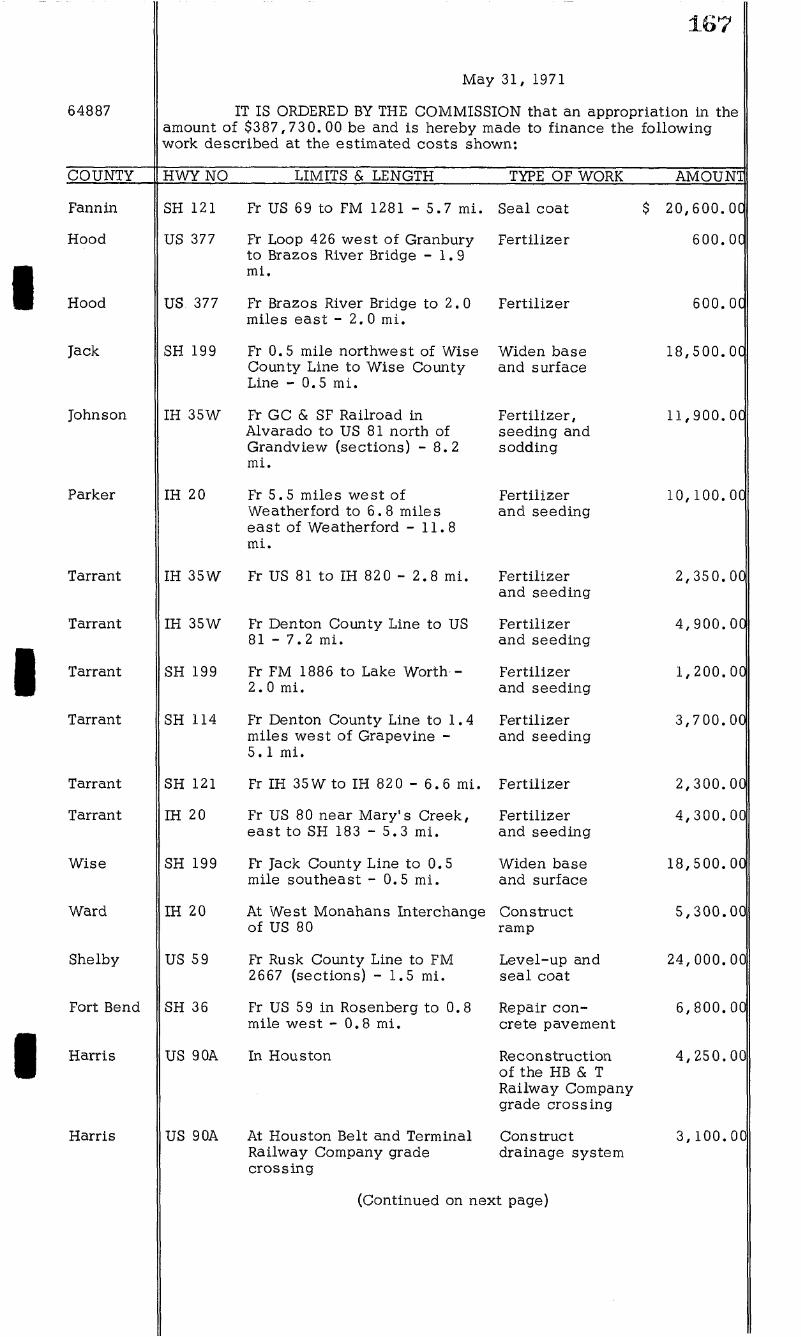
64887 IT IS ORDERED BY THE COMMISSION that an appropriation in the amount of $387,730.00 be and is hereby made to finance the fo l lowing work described at the estimated costs shown:
COUNTY HWY NO LIMITS & LENGTH TYPE OF WORK AMOUNT
Fannin SH 121 Fr US 69 to FM 1281 - 5.7 m i . Seal coat $ 20,600.00
Hood US 377 Fr Loop 426 west of Granbury to Brazos River Bridge - 1.9 m i .
Fert i l izer 600.0C
Hood US 377 Fr Brazos River Bridge to 2.0 miles east - 2 . 0 m l .
Fert i l izer 600.0C
Jack SH 199 Fr 0.5 mile northwest of Wise County Line to Wise County Line - 0.5 m i .
Widen base and surface
18,500.00
Johnson IH 35W Fr GC & SF Railroad in Alvarado to US 81 north o i Grandview (sections) - 8.2 m i .
Fer t i l izer , seeding and sodding
11,900.00
Parker IH 20 Fr 5.5 miles west o i Weatherford to 6.8 miles east of Weatherford - 11.8 m l .
Ferti l izer and seeding
10,100.00
Tarrant IH 35W Fr US 81 to IH 82 0 - 2.8 m i . Ferti l izer and seeding
2,350.00
Tarrant IH 35W Fr Denton County Line to US 8 1 - 7 . 2 m i .
Fert i l izer and seeding
4,900.00
Tarrant SH 199 Fr FM 1886 to Lake Worth -2. 0 m i .
Ferti l izer and seeding
1,200.00
Tarrant SH 114 Fr Denton County Line to 1.4 miles west of Grapevine -5 .1 m i .
Ferti l izer and seeding
3,700.00
Tarrant SH 121 Fr IH 35W to IH 820 - 6. 6 m l . Fert i l izer 2,300.00
Tarrant IH 20 Fr US 80 near Mary's Creek, east to SH 183 - 5.3 m i .
Fert i l izer and seeding
4 ,300.00
Wise SH 199 Fr Jack County Line to 0.5 mile southeast - 0.5 m i .
Widen base and surface
18,500.00
Ward IH 20 At West Monahans Interchange of US 80
Construct ramp
5,300.00
Shelby US 59 Fr Rusk County Line to FM 2667 (sections) - 1.5 m i .
Level-up and seal coat
24,000.00
Fort Bend SH 36 Fr US 59 in Rosenberg to 0.8 mile west - 0.8 m i .
Repair concrete pavement
6,800.00
Harris US 9 OA In Houston Reconstruction of the HB & T Railway Company grade crossing
4 ,250.00
Harris US 9 OA At Houston Belt and Terminal Railway Company grade crossing
Construct drainage system
3,100.00
(Continued on next page)
168
64887 Con inued —
May 3 1 , 1971
COUNTY HWY NO LIMITS & LENGTH TYPE OF WORK AMOUNT
Harris
Harris
Harris
Lee
Lee
Lee
Travis
Bexar
Bexar
Dallas
Navarro
Navarro
Rockwall
Harrison
Harrison
Jefierson
Liberty
Liberty
Orange
Orange
US 59
IH 45
SH 225
US 77
US 77
SH 21
US 290
SH 218
IH 410
IH 635
IH 45
IH 45
IH 30
IH 20
SH 105
SH 321
SH 105
IH 10
SH 87
At San Jacinto River Bridge and Relief Bridges
Fr Howard Drive to Almeda-Genoa Road - 3 .1 m i .
Fr T. & N . O. Railroad Overpass to 2.3 miles east - 2.3 m i .
At Allen Creek Bridge and Brushy Creek Bridge
At West Yegua Creek Bridge, Elm Creek Bridge, and Nails Creek Bridge
At West Yegua Creek Bridge
At Ben White Boulevard and Woodward Spur in Austin
Fr Robin Drive to Kit ty Hawk Road - 0.4 m i .
Meta l beam guard fence
Seal coat
Seal coat
Repair, clean and paint bridges
Repair, clean and paint bridges
Repair, clean and paint bridge
Reconstruction of the Missour i Pacific Railroad Company grade crossing
Widen base, structures and surface
Fr Callaghan Road to 0.3 mile Level-up west o i Ingram Road - 3.5 m i .
Fr Dowdy Ferry Road to St. Augustine Road
Fr Intersection SH 14 to 0.2 mile north - 0.2 m i .
Fr SH 14 to 0.3 mile southeast - 0.3 m i .
Clean and paint structure
Groove pavement
Groove pavement
Fr Dallas County Line to east Erosion control side o i Lake Ray Hubbard (sections) - 1.5 m i .
Sp 449 Fr SH 43 to FM 134 - 1.0 m i .
At Loop 281
At 0.4 mile west of US 09
Fr 12.6 miles south of Cleveland to 1.3 miles south - 1.3 m i .
At Tr ini ty River Bridge
At Intersection of FM 105
Repair base, leve l -up and seal coat
Revise ramps
Improve drainage
Construct outf a l l d i tch
Bridge Repairs
Construct l e f t turn lane
At 1.7 miles north o i Li t t le Cypress Creek
Improve drainage
(Continued on next page)
23,000.00
7,100.00
12,000.00
4,120.00
1,800.00
3,200.00
2,370.00
29,900.00
13,200.00
35,500.00
1, 850.00
3,350.00
37,700.00
4 ,600.00
7,600.00
7 ,600.00
16,940.00
5,900.00
15,000.00
7,100.00
169
May 3 1 , 1971
64887 Con inued —
COUNTY HWY NO LIMITS & LENGTH TYPE OF WORK AMOUNT
Brooks US 281 Fr M i l l e r Street in Falfurrias to SH 285 - 0 .1 m i .
Widen base and surface
$ 2,300.00
Zapata US 83 Fr 0. 9 mile north of Starr County to 4 .8 miles north (sections) - 4.8 m i .
Level-up and seal coat
2,600.00
TOTAL $ 387,730.00
64888 IT IS ORDERED BY THE COMMISSION that an appropriation in the amount of $128,550.00 be and is hereby made to finance the fo l lowing work described at the estimated costs shown:
COUNTY HWY NO LIMITS & LENGTH TYPE OF WORK AMOUNT
Grayson FM 3133 Fr SH 5 to Col l in County Line - 4 .0 m i .
Erosion control $ 3, 300. 00
Runnels FM 384 Fr Oak Creek to FM 383 - 4.7 m i .
Reconstruct shoulders
27,200.00
Angelina FM 2109 Fr FM 1669 in Huntington to 8.7 m i . east - 8.7 m i .
Seal coat 16,000.00
Brazoria FM 1462 At 1.4 m i . west of SH 35 in Alv in
Improve drainage 5,600.00
Lee FM 448 Fr Fayette County Line to Northrup - 3.9 m i .
Seal coat 8,800.00
Llano RM 965 Fr 7.9 m i . southwest o i SH 16 to SH 16 - 7. 9 m i .
Seal coat 17,600.00
Guadalupe FM 1150 Fr US 9OA to FM 1104 - 4.2 m i .
Level-up 15,200.00
Brazos FM 2154 Fr FM 2818 to M i l l i c a n -11.9 m i .
Seal coat 28,600.00
Hidalgo FM 1925 North o i Edinburg Reconstruction 6, 25 0.00 of the Southern Pacific Transportation Company grade crossing
TOTAL $ 128,550.00
64889 IT IS ORDERED BY THE COMMISSION that an appropriation in the amount of $14,847. 12 be and is hereby made to reimburse the io l lowing Dis t r ic ts for the sale of junk and unserviceable eguipment:
DISTRICT AMOUNT
1 $ 2 3 5 8
12 14 16 18 19 20
2,532.78 565.44
3,346.30 475.75
1,056.00 2,598.76 1,071.89 1,000.15
851.98 1,039.98
308.09
TOTAL $ 14,847.12
170
64850
64851
64852
May 61, 1571
IT IS OROE^OBYTHE COMMISSION that the State Engineer be authorizedtoproceedwiththepurchase ef needed replace-ment andadditionaicapitaiizedeguipment inthe amount ef $414,160.60 as perlisfattaohedandappropriationof the amount tothe following account ishereby made for this purpose. This Is Inaceordanoe withthe 1570-1571 Approved Budget for OepartmentalOperations, Hem 11. A. 6.
Account No. 44-1-5202 $414,100.00
Inaddltlon tothe aboveandinaccordance withMinute No. 66857, the attached i i s i i o i a i i n g $106,452.12 is submitted to ihe Siate Highway Engineer for review and submission to the Siate Highway Oom-missionand reflects allpurchases during themonthof May of ShopEguip-ment, Office Eumiture, Laboratory Eguipment, Office Machines, Engineering Eguipment andai i Oode Chart 27-BMisceilaneousEguipment Items.
WHEREAS, the State Highway Oommlsslon, under provision oi HouseRill 993enactedby the State Eegislature inthe 55th Regular Session, is authorized to i ix the maximum gross weight oi vehicles or combination thereoiand loader maximum axle and wheel loads which may be transported or moved on, over or upon any State Highway or Earmto Market or Ranch to Market Road a t a l e s s weight than the legal loads w h e n i t f o ioundthatgreatermaximnm weight wouldtendtorapidly deteriorate or destroy the roads, bridges or oulyerfo; and
WHEREAS, anengineeringand traiiio inyestigationhaye heen made oi the Highway System to determine and t lx the maximum loadsto he transportedcrmovedon, overorupon theroads and structures oi said Highway System; and
WHEREAS, it has heen determined irom this inyestigation that the loads en oertainstrnetures and seetfonsei roads oi the Highway System should berestrictedorpreviousrestrictions should beremoved;
HOW, THEREFORE, IT IS ORDERED that the maximum limits o i loads whioh may he transportedcrmovedon, overoruponthoseroads and structures as desorihedlnthe attached lists he iixedandremovedas set forththerein, supersedingany portionoiprevious action inconi l ic t herewith; and
IT IS EHRTHER ORDERED that the State Highway Engineer shall proceedwiththeerect ionandremovaloisigns as appropriate, thereby making the i ix ingandremovaloi theseload limitations eiiectiye and operative.
WHEREAS, theState Highway Ccmmissionoi theState oi Texas has ioundinorder topromotethe Rnhiic Safoty, to iaci i i ta te the Saietyanc moyementoi t ra i i ic , topreserve foe i inanciai investmentoi thepnhiio in its highways andtopromote the HationaiDefonse, puhifonecessity requires theiayingout , opening, constructing, reconstructing, maintaining, andoperatingoiCentroiied Access Highways foihe Siaie o i Texas asa pari e i ihe StateHighway Systematsuch locations as are neoessary io compietethe HaticnaiSystemoi interstate andDeienseHighways throughout the Stateoi Texas; and,
WHEREAS, ihe StateHighway Commission has ioundanddeter-minedthateachoi the foiiowing iisiedparoeis o i i and , sameheingmore particuiariy descrihed in theexhihi ts attached herefo, and suchadditionai iesserestates or property interests descrihed thereon, arenecessaryand suitable for nse ior suchpurposes audi t is necessary toacgulre iee simpfo ti t ie fo saidiand, asproyidedhyiaw, as a p a r t o i t h e StateHighway Sys-temtohe so constructed, reconstructed, maintained, andoperated thereor, andinthe exercise o i the poiice poweroithe State forthepreseryationoi humaniiie and saiety, andunderexist inglaws, thehighway tohe con-structedoneach suchparcel o i iand is designatedas a Controlled Access Highway; and,
(Continuedon next page)
64892 Con inued —
64893
r-M
May 31, 1971
WHEREAS, the State Highway Commission, through its duly authorized representatives, has negotiated with the owner or owners of each of such parcels of land and has been unable to agree with such ownej or owners as to the fair cash market value thereoi and damages, i f any;
NOW, THEREFORE, i t is hereby ordered that the State Highway Engineer be and he is hereby authorized and directed to transmit this request of the State Highway Commission to the Attorney General of the Statf of Texas to fi le or cause to be f i l ed , against a l l owners and lienholders, proceedings in eminent domain to acguire in the name oi and on behalf of the State of Texas, for said purposes, fee simple tit le to each such parcel of land as are more particularly described in each of the exhibits attached hereto and made a part hereoi, and such additional lesser estates or property interests as are more fu l ly described in each of said exhibits, save and excepting, o i l , gas and sulphur, as provided by law, to wit :
EXHIBIT: COUNTY: HIGHWAY: ACCOUNT N O . : PARCEL
A BELL Interstate 35 9009-5-22 122 B HARRIS Interstate 45 9012-7-23 4 C ATASCOSA Interstate 37 9015-12-11 14 &
14(E) D ATASCOSA Interstate 37 9015-12-11 16A &
16A(E) E EL PASO Loop 375 CBH L37 5(2) 10
WHEREAS, the State Highway Commission of the State of Texas has found in order to promote the Public Safety, to facilitate the Safety anij movement of t raff ic , to preserve the financial investment of the public in its highways and to promote the National Defense, public necessity re -guires the laying out, opening, constructing, reconstructing, maintaining, and operating df Controlled Access Highways in the State oi Texas as a part of the State Highway System at such locations as are necessary to complete the National System o i Interstate and Defense Highways through-] out the State of Texas; and,
WHEREAS, the State Highway Commission has iound and determined that each of the following listed parcels of land, same being more particularly described in the exhibits attached hereto, and such additional lesser estates or property interests described thereon, are necessary and suitable ior use ior such purposes and i t is necessary to acquire fee simpl tit le to said land, as provided by law, as a part of the State Highway System to be so constructed, reconstructed, maintained, and operated thereon] and in the exercise oi the police power of the State for the preservation of human l ife and safety, and under existing laws, the highway to be constructed on each such parcel of land is designated as a Controlled Access Highway, and roads are to be built as a part of said highway whereby the right of ingress and egress to or from the remaining private property abutting on said highway is not to be denied; and,
WHEREAS, the State Highway Commission, through its duly authorized representatives, has negotiated with the owner or owners of each of such parcels of land and has been unable to agree with such owneij or owners as to the fair cash market value thereof and damages, i f any;
NOW, THEREFORE, i t is hereby ordered that the State Highway Engineer be and he is hereby authorized and directed to transmit this request of the State Highway Commission to the Attorney General of the Stat^ of Texas to f i le or cause to be f i l ed , against a l l owners and lienholders, proceedings in eminent domain to acquire in the name oi and on behalf of the State of Texas, for said purposes, iee simple t i t le to each such parcel of land as are more particularly described in each of the exhibits attached hereto and made a part hereof, and such additional lesser estates or property interests as are more ful ly described in each of said exhibits, save and excepting, o i l , gas and sulphur, as provided by law, to wit :
(Continued on next page)

172
Con inued —
EXHIBIT: COUNTY: HIGHWAY: ACCOUNT N O . : PARCEL:
A BELL Interstate 35 9009-5-22 128 B BELL Interstate 35 9009-5-22 157 C BELL Interstate 35 9009-5-22 177 D ATASCOSA Interstate 37 9015-12-11 6 E LIVE OAK Interstate 37 9016-12-11 9A &
9A(E) F LIVE OAK Interstate 37 9016-12-11 10
May 31, 1971
WHEREAS, in BRAZORIA COUNTY, Texas, on FARM TO MARKET ROAD 523, certain land is used for State Highway purposes by the State Highway Department; and
WHEREAS, the United States of America, in conjunction and cooperation with the Velasco Drainage District, is constructing the Free-port and Vicinity, Texas, Hurricane-Flood Protection Project as authorized by Act of Congress dated October 23, 1962, Public Law 87-874, in accordance with plans set out in House Document No. 495, 87th Congress, Second Session; and
WHEREAS, the State and the Drainage District in its capacity as local sponsor ior said Project, entered into a contract dated May 29, 1969 providing for the reconstruction of a portion of Farm to Market Road 523 at its intersection with the flood protection levee at approximate Highway centerline Station 201+12.6 to accommodate construction of the Project near Freeport, Brazoria County, Texas; and,
WHEREAS, the alteration has been accomplished by the State, and the Drainage District has reimbursed the State for the work performed pursuant to the contract terms; and
WHEREAS, the State has been requested to grant and convey unto the Velasco Drainage District and its assigns the perpetual right, privilegf and easement to enter upon, occupy and use the land described in Exhibit A, attached hereto and made a part hereof, for the purposes of constructin operating and maintaining the Freeport and Vicinity Hurricane-Flood Protection Levee and any and al l structures relating thereto; and
WHEREAS, Article 5244a-3, V. A. C. S., authorizes the Governo of Texas, upon the recommendation oi the State Highway Commission, to convey to the United States oi America or to any political subdivision, agency or instrumentality o i the State which is cooperating with the United States in any such project, with or without monetary consideration therefor, an easement or other interest in land under control of the Texas Highway Department as may be necessary for the construction and maintenance of such project as mentioned above; and
WHEREAS, it is the opinion of the State Highway Commission that it is proper and correct that the State grant and convey unto the Velasco Drainage District, the perpetual right, privilege and easement to enter upon, occupy and use the aforementioned land as necessary for the construction, operation and maintenance o i the aforesaid flood control project;
NOW, THEREFORE, in consideration of the foregoing premises a n | in accordance with the provisions and within the purview o i the aforementioned Statute, i t is hereby recommended by the State Highway Commission, subject to approval by the Attorney General, that the Governor o i Texas execute a proper instrument granting and conveying to the Velasco Drainag| District, its successors and assigns, the perpetual right, privilege and easement to enter upon, occupy and use the land described in the attachec Exhibit A ior the purpose oi constructing, operating and maintaining the Freeport and Vicinity, Texas, Hurricane-Flood Protection Levee and any
(Continued on next page)
64894 Con
173
May 31, 1971
inued —
and al l structures related thereto; however, while expressly subordinating al l of the State's rights in said land to the rights to be conveyed to the Drainage District, the conveyance w i l l reserve unto the State a l l rights which i t now has to use said land for highway purposes to the extent that the exercise of such rights w i l l not conflict or interfere with the rights herein conveyed to the Drainage District . In connection with this subordination, but not in limitation thereoi, the State for itself and its assigns, covenants with the Drainage District that it w i l l not breach the levee to alter, lower or add to the existing highway facili t ies located on the land subject to this easement without first submitting plans and drawings oi such work to the Drainage District; that no such work w i l l begin without the prior approval of the Chairman, Board of Supervisors, Velasco Drainage District; and that upon receiving such approval the State w i l l perform such work expeditiously with due regard to the possibility of impending hurricane or flood.
WHEREAS, in BRAZORIA COUNTY, Texas, on STATE HIGHWAY 288 and FARM TO MARKET ROAD 1495, certain land is used for State Highway purposes by the State Highway Department; and
WHEREAS, the United States of America, in conjunction and cooperation with the Velasco Drainage District , is constructing the Free-port and Vicinity, Texas, Hurricane Flood Protection Project, as authorize by Act of Congress dated October 23, 1962, Public Law 87-874, in accordance with plans set out in House Document No. 495, 87th Congress, Second Session; and
WHEREAS, the State and the Drainage District in its capacity as local sponsor for said Project, entered into a contract dated December 8, 1969, providing for the State to grant to the Drainage District, and its assigns, an easement and subordination in the land described in Exhibit A, attached hereto and made a part hereoi; and
WHEREAS, Article 5244a-3, V. A. C. S., authorizes the Governo: 01 Texas, upon the recommendation o i the State Highway Commission, to convey to the United States of America or any political subdivision, agencjy or instrumentality oi the State which is cooperating with the United States in any such project, with or without monetary consideration therefor, an easement or other interest in land under control o i the Texas Highway Department as may be necessary for the construction and maintenance of such project as mentioned above; and
WHEREAS, i t is the opinion of the State Highway Commission tha i t is proper and correct that the State grant and convey the requested right in the aforementioned land to the Velasco Drainage District , as necessary for the construction, operation and maintenance o i the aforesaid flood control project;
NOW, THEREFORE, in consideration of the foregoing premises an, in accordance with the provisions and within the purview of the aforementioned Statute, i t is hereby recommended by the State Highway Commissio:^, subject to approval by the Attorney General, that the Governor oi Texas execute a proper instrument granting unto the Velasco Drainage District, its successors and assigns, the perpetual right, privilege and easement to enter upon, occupy and use the land described as Parcels Nos. 1 and 2 in the attached Exhibit A, for the purpose of constructing, operating and maintaining the Freeport and Vicinity Hurricane Flood Protection Levee and any and a l l structures relating thereto; however, while expressly subordinating a l l o i the State's rights in said land to the rights to be conveyed to the Drainage District, the conveyance w i l l reserve unto the State a l l rights which i t now has to use said land for highway purposes to the extent that the exercise o i such rights w i l l not conflict or interfere with the rights conveyed to the Drainage District. In connection with this subordination, but not in limitation thereof, the State for itself and its assign covenants with the Drainage District that i t w i l l not breach the levee to
(Continued on next page)
174
64895 Con
64896
May 61, 1971
tnued—
alter, loweroraddto thehlghway facili t ies locatedonthe landsubject tothlseasement without first submitting plans anddrawlngsof suchwork totheDralnage District; that nosuchwork w i l l beglnwlthouttheprlor approvalof the Chairman, Boardcf Supervisors, Velasco Drainage District andthat upon recelvlngsuch approval, the State wll lperform suchwork expeditiously wl thdueregardtothe possibility of Impendlnghurrlcane or flood. Inaddltlon to theaboveeasement and subordination, the Statewll hythe samepresents and for the same consideration, grant andconvey unto the Drainage District and its assigns:
a. Aperpetual right Inthe landdesorlhed as Parcels Nos. 6, 4and 5, Inthe attached Exhibit A, to operate, malntalnand reconstruct thereon as an Integral part of the Preeport Hurricane Plood Protection Project, the State'sexlstlngearthen levee on said land, a tamlnlmumhelghtcf five feet above mean sea level , andtheState covenants wi ththe Drainage District and Itsasslgns that i t w i l l neither perform nor authorize the performance of any actor acts intheeasement area which would reduce its existing levee below the height aforesaldunless Itobtalns the advance wrlttenapproval therefor fromtheDralnage District; and
b. A temporary easement to enter uponthelanddeslgnatedln theattachedPxhlbltAas Parcels Nos. 6, 4and 5, with men, materlaland eguipment andtouse same Inanymannercon-sonant wlthconstructlonof the Preeport Hurricane Plood Protection Project. The termof this temporary construction easement shall heglnupon Inl t la t lonof ccnstructlononthe Preeport Pump StatlonlnterceptorChannelandshallcontlnue Inef fec tun t l l comple t lonof such construction, but In no event beyondflve years fromthe date of the Instrument con-veylngsuch right to the DralnageDlstrlct.
WHEREAS, InOATTASOOHHTY,Texas, on INTERSTATE HIOHWAY 35, the Oounty acquired Inthe State'sname at no oost tothe State an easement Interest Incertaln land neededforhlghway purposes hythe StateHighway E^epartment, said easement helnggrantedto the Statehy InstrumentofrecordlnVoIume 2157, Rage447, of theOeed Records of Oallas Oounty, Texas; and
WHEREAS, apor t tono tsa ld land Is nolongor needed tor highway purposes or tor the use of citizens as aroad, saidsurplus land helng more particularly descrlhedlnExhlhlt A, attached hereto and made apart hereof; and
WHEREAS, theState, acting hy and through the State Highway Oommlsslon, andOharles Eorsee enteredlntoan agreement wherehy as partconslderatlonfortheconyeyanoehy Mr. Eorseetothe State of cerD talnland needed Iorhighway r lghtot way purposes, the State Highway OommlssIonwouIdrecommendtotheOoyernorof Texas that the State's Interest Inthe aforementioned surplus land he gultclalmedto Oharles Eorsee; and
WHEREAS, Article 5575a, V. A. O. S., authorizes the State's conyeyanceof such surplusproperty or Interest therein forc ther landor Interest therein neededhythe State forhlghway purposes; and
WHEREAS, It Is the opinion cf theState Highway Oommlsslontha It Is proper and correct that the S ta teconyeya l l l t s r lgh t , t i t le andlnter-est In said surplus landto Oharles Eorsee aspart consideration forh ls conyeyanceoftheneeded landtothe State;
NOW, THEREFORE, Inoonslderatlonof theforegolng premises anA Inaooordanoe wl th theproyls lonsandwlthln thepurylew of the aforemen-tlonedStatute, It Is herehy recommended hythe State Highway Oommlsslon, suhjectto approval hythe Attorney Oeneral, that theOovernor of Texas execute aproper Instrument quitclaiming a l l o t the State'srlght, t l t leand Interest In saldsurplusland to Oharles Eorsee, said land helng more particularly descrihed In Exhlhlt A, attached hereto and made apart hereof
64897
I 64898
64899
I 64900
64901
64902
I 64903
175
May 31, 1971
In BEXAR COUNTY, on bids received May 25, 1971, contract for construction of grading, drainage structures, separations, flexible base, asphalt treated base, hot mix asphaltic concrete pavement, signing, delineation and pavement markings from 0.4 mile northeast of Atascosa County Line north to 0.6 mile northeast of Spur 422 in San Antonio, a distance of 15.649 miles on INTERSTATE HIGHWAY 35, Control 17-2-37, 17-3-33, 17-9-26, 17-2-38, 17-3-34 and 17-9-27, Federal Project I 35-2(98)134 and I 35-2(41)134, is awarded to Leo P. Cloud, Jr. and Son and J. H . Strain & Sons, Inc . , New Braunfels, Texas, for $7,605,548.21, which is the lowest and best bid, subject to the concurrence of the Federal Highway Administration.
In BEXAR COUNTY, on bids received May 26, 1971, contract for construction of grading, structures, base and surfacing at Southern Pacific Railroad 2.1 miles southwest oi Interstate Highway 410, a distance of 0.435 mile on FARM TO MARKET ROAD 2536 and INTERSTATE HIGHWAY 410 Control C 5 21-5-25 and C 2440-1-5, is awarded to Killian-House Compan San Antonio, Texas, for $387, 161.39, which is the lowest and best bid.
In BOWIE COUNTY, on bids received May 26, 1971, contract for construction of grading, widen structures, concrete pavement, jointed reinforced and modernization of traffic signal from 0.2 mile west of Robison Road to 0.2 mile east of Robison Road and from 0.1 mile south of U . S. Highway 67 to 0.1 mile north of U. S. Highway 67, a distance of 0.575 mile on TOPICS STREET 2 and U . S. HIGHWAY 67, Control 10-13-36 and 5019-1-1, Federal Project T 9020(2), is awarded to Calvin Carter Construction Co. , Inc . , Texarkana, Texas, ior $634, 912.45, which is the lowest and best bid, subject to the concurrence oi the Federal Highway Administration.
In BRISCOE COUNTY, on bids received May 26, 1971, contract for construction of grading, structures, foundation course and hot mix asphaltic concrete pavement from intersection of State Highway 207 in Sllverton, east to Top oi Caprock, a distance oi 11.756 miles on STATE HIGHWAY 86, Control C 303-3-26, is awarded to Ivan Dement, Inc . , Amarillo, Texas, for $478,784.26, which is the lowest and best bid.
In CAMERON COUNTY, on bids received May 25, 1971, contract for construction of grading, structures, base and surfacing from Loop 448 in Combes west to Hidalgo County Line, a distance of 8.540 miles on STATE HIGHWAY 107, Control C 342-3-12, is awarded to Ballenger Construction Company, San Benito, Texas, for $426,983.77, which is the lowest and best bid.
In CHAMBERS COUNTY, on bids received May 26, 1971, contract for construction of grading, structures, base and surfacing from Interstate Highway 10, 2.8 miles west of Farm to Market Road 565 south, to Farm to Market Road 2354, a distance oi 3.945 miles on FARM TO MARKET ROAD
R. 3180, Control 3271-1-2, Federal Project S 3204 (1)A, is awarded to W. Boyd, Inc . , Center, Texas, for $662,081.16, which is the lowest and best bid.
In COCHRAN COUNTY, on bids received May 26, 1971, contract for construction of grading, structures, base and surfacing from State Highway 214, 9.0 miles south of Lehman, east to Farm to Market Road 1780, a distance of 12.446 miles on FARM TO MARKET ROAD 1585, Control 3126-2-1, Federal Project RS 2970 (2)A, is awarded to Western Pavers, Inc . , Lubbock, Texas, for $196,883.67, which is the lowest and best bid.
176
64904
64905
I 64906
64907
64908
I 64909
64910
I
May 31, 1971
In COMAL COUNTY, on bids received May 25, 1971, contract ior construction of grading, structures, base and surfacing from Farm to Market Road 267 3 near Startzville southwest to State Highway 46, a distance of 6.351 miles on FARM TO MARKET ROAD 3159, Control A 3213-1-2, is awarded to Dean "Word Company, New Brauniels, Texas, for $419,915.43, which is the lowest and best bid.
In DALLAS COUNTY, on bids received May 25, 1971, contract for widening grading, structures, base and surfacing from 0.5 mile east of Radio Road to 0.4 mile west of O'Connor Road, a distance oi 4.240 miles on STATE HIGHWAY 114, Control 353-4-29, Federal Project F 1116(14), is awarded to M & S Construction Company and Uvalde Construction Compan ', Dallas, Texas, for $2,949,578.03, which is the lowest and best bid, subject to the concurrence of the Federal Highway Administration.
In DALLAS COUNTY, on bids received May 26, 1971, contract for signing and delineation irom south of Grand Avenue to Paciiic Avenue, a distance of 1.658 miles on INTERSTATE HIGHWAYS 45 and 345, Control 92-14-19 and 92-14-20, Federal Project I 45-3(27)283 and I 345-3(58)284, is awarded to Mica Corporation, Wichita Falls, Texas, ior $163,542.68, which is the lowest and best bid, subject to the concurrence of the Federal Highway Administration.
In DENTON COUNTY, on bids received May 25, 1971, contract for construction of asphalt stabilized base from State Highway 24 to Mustang, a distance of 7.559 miles on FARM TO MARKET ROAD 1385, Control C 1315-1-14, is awarded to Jagoe-Public Company, Denton, Texas, for $201,501. 09, which is the lowest and best bid.
In DENTON COUNTY, on bids received May 26, 1971, contract for construction o i grading, structures, base and surfacing from 0.5 mile south of Clear Creek north 3.8 miles, a distance of 3.756 miles on FARM TO MARKET ROAD 428, Control 81-5-20 and C 81-5-21, Federal Project S 1118 (3), is awarded to R. W. McJCinney and C. R. Hudnall, Nacogdoches, Texas, ior $526,870.34, which is the lowest and best bid.
In EASTLAND COUNTY, on bids received May 26, 1971, contract for construction of grading, structures, base and surfacing from U. S. Highway 80 in Eastland north and west to U . S. Highway 183, a distance of 7.102 miles on FARM TO MARKET ROAD 3101, Control 3181-1-1, Federal Project S 3172 (1)A, is awarded to Acme Bridge Company, Inc. Austin, Texas, for $305, 168.27, which is the lowest and best bid.
In ELLIS COUNTY, on bids received May 25, 1971, contract ior construction of grading, base and surfacing in the county and between the limits listed below:
COUNTY PROJECT HIGHWAY LENGTH LIMITS
Ellis C 92-5-27 IH 45 5.798 mi. From US 75 to Navarro County Line
Ellis C 260-2-19 US 67 1.675 mi . From approximately 1. J miles southwest o i Loop 489 southwest of Midlothian
Ellis C 26 0-4-1 Loop 489 1.097 mi. From US 67 southwest o i Midlothian to US 287 in Midlothian
(Continued on next page)
64910 Con Inued --
I
64911
64912
I 64913
64914
64915
I 64916
177
May 31, 1971
COUNTY PROTECT HIGHWAY LENGTH LIMITS
Ellis
Ellis
Ellis
C 1160-1-18 FM 877
C 1318-1-5 FM 1181
C 1393-1-7 FM 308
6.269 mi . From 2.0 miles north of Howard to SH 34
9.777 mi. From US 75 to northeast of Village Creek Bridge
3.264 mi. From north of Milford to US 77
a total length of 27. 880 miles, is awarded to Young Brothers, Inc . , Contractors, Waco, Texas, ior $584,771.20, which is the lowest and best bid.
In ELLIS COUNTY, on bids received May 26, 1971, contract for construction of grading, structures, base and surfacing irom Johnson County Line to Farm to Market Road 157, a distance of 2.579 miles on FARM TO MARKET ROAD 2258, Control A 1599-5-1, is awarded to Dan Buckner, Inc . , Cleburne, Texas, for $153,502.61, which is the lowest and best bid.
In HARRIS COUNTY, on bids received May 25, 1971, contract for preparing right of way from Fannin Street to Almeda Road in Houston, a distance of 0.00 mile on U . S. HIGHWAY 59, Control 27-13-64, Federal Project U 514(66), is awarded to Robert Hal l , Valley M i l l s , Texas, for $28, 125. 00, which is the lowest and best bid, subject to the concurrence of the Federal Highway Administration.
In HARRIS COUNTY, on bids received May 26, 1971, contract for safety lighting, median guard fence and headlight barrier fence from 0.13 mile north of Aldine Road to 0.56 mile south oi Gears Road, a distance of 1.002 miles on INTERSTATE HIGHWAY 45, Control C 110-6-43 and 110-6-44, Federal Project I 45-1(124)060, is awarded to Toyd Electric Co. , Inc . , San Antonio, Texas, for $164,7 64.21, which is the lowest and best bid, subject to the concurrence of the Federal Highway Administration.
In HARRIS COUNTY, on bids received May 26, 1971, contract for construction oi grading, structures, base and surfacing irom Farm to Market Road 149 to Howard Street in Tomball, a distance oi 1.7 27 miles on FARM TO MARKET ROAD 2920, Control A 2941-2-4, is awarded to A. M . Vogel, Inc . , Houston, Texas, for $994,011.40, which is the lowest and best bid.
In HENDERSON COUNTY, on bids received May 25, 1971, contract ior construction oi grading, structures, base and surfacing irom 2.1 miles west o i Farm to Market Road 90, east to Farm to Market Road 90 and from near Clear Creek to State Highway 31 in Malakoff, a distance oi 5.180 miles on FARM TO MARKET ROADS 90 and 3 062, Control C 646-5-8 and 3193-1-3, Federal Project S 3205 (1)A, is awarded to R. C. Buckner, Jacksonville, Texas, for $364, 128.39, which is the lowest and best bid.
In HENDERSON COUNTY, on bids received May 26, 1971, contract for construction of grading, structures, base and surfacing from Farm to Market Road 2495 near Athens Water Treatment Plant, southeast to County Road, a distance of 2. 05 0 miles on FARM TO MARKET ROAD 2892, Control 3262-1-2, Federal Project S 3211 (l)A, is awarded to Reynolds-Land, Inc . , Tyler, Texas, for $77,703.36, which is the lowest and best bid.

64917
I 64918
64919
I 64920
64921
64922
I 64923
1 K'| t.
May 31, 1971
In HIDALGO COUNTY, on bids received May 26, 1971, contract for construction of grading, structures, base and surfacing in McAllen, from North City Limits to Loop 374, from Farm to Market Road 494 to Farm to Market Road 1926 and from Loop 374 west of McAllen to U . S. Highway 83 Expressway, a distance of 5.945 miles on STATE HIGHWAY 336, FARM TO MARKET ROAD 1924 and SPUR 487, Control C 621-1-34, C 621-1-36, 1802-1-9 and 2094-1-10, Federal Project S 1831(2)A and US 2373(3), is awarded to South Texas Construction Co., Corpus Christi, Texas, ior $495, 084.42, which is the lowest and best bid, subject to the concurrence of the Federal Highway Administration.
In TIM HOGG and DUVAL COUNTIES, on bids received May 25, 1971, contract for construction of grading, structures, base and surfacing in Hebbronville, from State Highway 359, south, east, and north 0.9 mile, from north end of curb and gutter in Hebbronville to State Highway 359 and irom 0.8 mile south of U . S. Highway 59 in Freer to State Highway 339 south of Freer, a distance of 3.772 miles on STATE HIGHWAYS 359 and 16, Control C 86-6-18, C 86-7-19, C 517-4-23 and C 517-10-7, is awarded to B & E Construction Co., Corpus Christi, Texas, ior $271,680.90, which is the lowest and best bid.
In KINNEY and VAT VERDE COUNTIES, on bids received May 25, 1971, contract for construction oi seal coat and rock asphalt pavement from Val Verde County Line to 3.5 miles west of Brackettville, irom 3.5 miles west o i Brackettville to Brackettville West City Limit and from 11.7 miles south of Edwards County Line to Edwards County Line, a distance of 28.491 miles on U . S. HIGHWAYS 90 and 277, Control C 23-2-27, C 23-3-24 and C 160-4-12, is awarded to W. D. Turner Construction Company, Lubbock, Texas, for $112,932.00, which is the lowest and best bid.
In KNOX COUNTY, on bids received May 26, 1971, contract for construction of grading, structures, base and surfacing from Farm to Mar ket Road 2534, south to Farm to Market Road 1043 and from Munday southeast to Haskell County Line, a distance o i 9. 049 miles on FARM TO MAR KET ROADS 3202 and 1587, Control C 1512-1-6 and 3295-1-1, Federal Project RS 3214 (1)A, is awarded to H . L. Freeland, Inc. and George M . Amthor, San Antonio, Texas, for $306,517.50, which is the lowest and best bid.
In MADISON COUNTY, on bids received May 25, 1971, contract for construction of grading, structures, base and surfacing from U . S. Highway 190, 3.8 miles southwest of Farm to Market Road 39, northeast to Road Intersection, a distance of 2.533 miles on FARM TO MARKET ROAD 2865, Control 3303,1-2, Federal Project RS 3215 (1)A, is awarded to Pit Construction Co., Lufkin, Texas, ior $88,870.34, which is the lowest and best bid.
In MOORE COUNTY, on bids received May 25, 1971, contract for construction of hot mix asphaltic concrete pavement irom 19th Street to North 4th Street in Dumas and from U. S. Highways 87 and 287 to Wilson Street in Dumas, a distance of 2.519 miles on U . S. HIGHWAYS 87 and 287 and FARM TO MARKET ROAD 722, Control C 66-4-26, C 66-5-26 and C 727-4-6, is awarded to Gilvin-Terr i l l , Inc . , Amarillo, Texas, for $38,925.03, which is the lowest and best bid.
In NACOGDOCHES COUNTY, on bids received May 25, 1971, con tract for construction of grading, structures, base and surfacing from 2.4 miles notheast of Farm to Market Road 2112, east to Farm to Market Road 95, a distance of 4.458 miles on FARM TO MARKET ROAD 1878, Control 3248-1-1, Federal Project S 2103 (2)A, is awarded to T. Richard Vardeman Inc . , Nacogdoches, Texas, for $159,648.73, which is the lowest and bes bid.

64924
64925
I 64926
64927
64928
I 64929
64930
64931
179
May 31, 1971
In POLK COUNTY, on bids received May 26, 1971, contract ior construction of hot mix asphaltic concrete pavement and seal coat shoulders from Corrigan to Neohes River, a distance of 8.400 miles on U. S. HIGHWAY 59, Control C 176-4-37, is awarded to Gaylord Construction Co., Houston, Texas, for $147,740.45, which is the lowest and best bid.
In POTTER COUNTY, on bids received May 25, 1971, contract for construction of grading, structures, asphalt stabilized base and concrete pavement in City of Amarillo at Fillmore Street Underpass, a distance of 0.07 2 mile on U . S. HIGHWAY 87, Control C 41-7-49, is awarded to Gilvin-Terr i l l , Inc . , Amarillo, Texas, ior $71,058.63, which is the lowest and best bid.
In POTTER COUNTY, on bids received May 25, 1971, contract for illumination at Interchange of Interstate Highway 40 and Spur 468 in Amarillo, a distance of 1.100 miles on INTERSTATE HIGHWAY 40, Control 275-1-52, Federal Project I 40-1(85)077, is awarded to Arlington Equipment Company, Inc . , Arlington, Texas, for $82,385. 25, which is the lowest and best bid, subject to the concurrence of the Federal Highway Administration.
In RANDALL COUNTY, on bids received May 26, 1971, contract ior construction of grading, structures, base and surfacing from Loop 335 north to 1.0 mile south o i U . S. Highway 60-87, a distance of 2.260 miles on FARM TO MARKET ROAD 1541, Control C 1480-2-9, is awarded to Gilvin-Terr i l l , Inc . , Amarillo, Texas, ior $167, 026.38, which is the lowest and beat bid.
In SMITH and CHEROKEE COUNTIES, on bids received May 25, 1971, contract for widening drainage structures from Alabama Street in Troup to Cherokee County Line and from Smith County Line,east to Rusk County Line, a distance of 8.602 miles on FARM TO MARKET ROAD 13, Control C 591-1-3 and C 591-3-5, is awarded to Pit Construction Co., Lufkin, Texas, for $48,853.08, which is the lowest and best bid.
In SMITH and GREGG COUNTIES, on bids received May 25, 1971, contract for construction oi guard fence at grade separations and interchange structures from U. S. Highway 69 in Smith County, east to 16th Street in Longview, a distance of 39.866 miles on INTERSTATE HIGHWAY 20, Control 495-4-21, 495-5-13, 495-6-9 and 495-7-14, Federal Project I 20-6(40)569, is awarded to Mica Corporation, Wichita Falls, Texas, for $83,569.00, which is the lowest and best bid, subject to the concurrence of the Federal Highway Administration.
In TARRANT COUNTY, on bids received May 26, 1971, contract for construction of grading, drainage facilities and structures from Interstate Highway 20 southeast to Farm to Market Road 157, a distance o i 6.307 miles on U . S. HIGHWAY 287, Control 172-9-2, Federal Project F 385(38), is awarded to Adams Brothers, Inc . , Athens, Texas, for $3,730,443.46, which is the lowest and best bid, subject to the concurrence of the Federal Highway Administration.
In UVALDE COUNTY, on bids received May 26, 1971, contract for traffic signal system in City of Uvalde at High Street, U . S. Highway 83, Camp Street, Farm to Market Road 1023, Nopal Street and at Camp Street, a distance of 0. 000 mile on U . S. HIGHWAYS 90 and 83 and FARM TO MARKET ROAD 862, Control C 24-1-50, C 36-8-25 and C 2835-1-3, is awarded to Forest Park Properties of Arlington, Inc . , Arlington, Texas, for $59,000.00, which is the lowest and best bid.
64932
64933
I
64934
64935
I 64936
64937
64938
I 64939 JCD
180
May 31, 1971
In WALKER COUNTY, on bids received May 26, 1971, contract for widening railroad overpass and approaches at Missouri Pacific Railroad, a distance of 0.795 mile on U . S. HIGHWAY 190, Control C 213-1-16, is awarded to R. B. Butler, Inc. , Bryan, Texas, for $84,056.10, which is the lowest and best bid.
In WHARTON and FAYETTE COUNTIES, on bids received May 26, 1971, contract for construction oi hot mix asphaltic concrete pavement from Colorado County Line to 200 feet east of State Highway 60, from Alabama Road in Wharton to 495 feet south of Farm to Market Road 442 and from 4.9 miles east of State Highway 159 to Colorado County Line, a distance of 26.931 miles on STATE HIGHWAYS 60 and 71 and U . S. HIGHWAY 9OA, Control C 27-4-24, C 241-1-20 and C 266-1-34, is awarded to Jones G. Finke Inc . , Sealy, Texas, for $287,997.41, which is the lowest and best bid.
In WISE COUNTY, on bids received May 25, 1971, contract for construction oi bridge and approaches at proposed Spillway Channel from Lake Bridgeport, a distance oi 0.160 mile on FARM TO MARKET ROAD 1658 Control C 1606-1-9, is awarded to Zack Burke tt Co. , Graham, Texas, for $119, 339.47, which is the lowest and best bid, subject to the concurrence of Tarrant County Water Control and Improvement District No. 1.
In CAMERON COUNTY, on bids received until 2:30 P . M . , May 20, 1971, at Austin, the contract ior construction of an ADDITION TO and ALTERATION OF CONSTRUCTION BUILDING on the Maintenance Site at San Benito, Job MC-21-Q-8, Budget 21, Authorization 2408, is awarded to Stotler Construction Co., 521 Nebraska, San Juan, Texas, for $59,700.00, which is the lowest and best bid.
In GARZA COUNTY, on bids received until 2:00 P . M . , May 13, 1971, at Lubbock, the contract for construction of CHAIN LINK FENCING ON REST AREA on U . S. Highway 84 approximately 3.3 miles northwest of Post, Job MC-53-4-23, Budget 5, is awarded to United States Steel Corporation, P. O. Box 1567, Lubbock, Texas, ior $6, 185. 00, which is the lowest and best bid.
In TOHNSON COUNTY, on bids received 9:00 A . M . , May 13, 1971, at Fort Worth, contract for installation of a volume density, fu l l traffic actuated signal with saiety lighting at the intersection of State Highway 174 with Summercrest Street,in Burleson, a distance of 0.00 mile on STATE HIGHWAY 174, Control 19-1-49, Maintenance Project MC 19-1-49, is awarded to Blackburn Electric Service, Fort Worth, Texas, for $16,390. 00, which is the lowest and best bid.
In WILBARGER COUNTY, on bids received until 2:30 P . M . , May 20, 1971, at Austin, the contract for construction of a LABORATORY, SERVICE STATION and STORAGE BUILDING, a MAINTENANCE and CONSTRUCTION ADDITION TO EXISTING WAREHOUSE, and OUTSIDE UTILITIES and GROUND IMPROVEMENTS on the Maintenance Site at Vernon, Jobs MC-3-M-10, MC-3-D-11, and MC-3-E-11, Budget 3, is awarded to Texoma Construction & Engineering, Inc . , P. O. Box 1711, Wichita Falls, Texas, for $129,879. 00, which is the lowest and best bid.
WHEREAS, in BOWIE COUNTY, the City o i Texarkana has requested assistance in the improvement of West 14th Street extending from U. S. Highway 82 (Texas Boulevard) to U. S. Highways 59 and 71 (State-line Avenue), a distance of approximately 0.5 mile; and
WHEREAS, it,has been determined that the proposed work is eligible for participation in the Federal TOPICS Program; and
(Continued on next page)
64939 Con inued —
181
May 31, 1971
WHEREAS, it is the desire o i the Texas Highway Department to assist the City of Texarkana in the improvement of this thoroughfare;
NOW, THEREFORE, the State Highway Engineer is directed to tender the following proposal to the City oi Texarkana ior the development of such a project:
Provided the City of Texarkana w i l l :
1. Furnish a l l necessary right of way clear of obstructions and provide ior the adjustment of utili t ies as may be reguired.
2. Provide for the construction of curb and gutter where none now exists, storm sewers i f required, driveways and sidewalks and agree to make such installations in accordance with governing policies and regulations of the Department.
3. Maintain a l l of the work constructed as a part of the project and operate the installations upon completion in a manner satisiactory to the Department.
4. Adopt and enforce such ordinances and regulations as may be necessary for proper operation of the installations.
The Texas Highway Department w i l l :
Prepare construction plans and specifications for the proposed improvements.
2. Provide relocation assistance as may be reguired and determined to be eligible under the Relocation Assistance Program, at an estimated cost of $14,000.00.
3. Provide for widening pavement, small structures and the addi • tion and upgrading of traffic control devices, at an estimated cost o i $125, 000.00.
Upon acceptance of the provisions of this Order by the appropriat 2 officials of the City of Texarkana, IT IS ORDERED that 14th Street extendir g from U. S. Highway 82 to U . S. Highways 59 and 71 , a distance o i appro) i -mately 0.5 mile, be and is hereby designated as a TOPICS STREET, and the State Highway Engineer is directed to enter into agreement with the City covering the details of the proposed improvements, to proceed with the engineering development of the project and after the City has fu l f i l led its responsibilities, proceed with relocation assistance and construction as authorized herein in the most feasible and economical manner, financing the cost in the Federal TOPICS Program.
It is understood that the City may discharge its construction obligations as outlined herein in any manner as they may elect. In the event the City desires the State to include their portion of the work in the State's construction contract, the State Highway Engineer is hereby authorized to enter into agreement with the City for such work and its cost as may be agreed upon.
This Order shall become operative upon acceptance by the City of Texarkana and i f not accepted within 90 days of the date hereof, the action herein contained shall be automatically cancelled.
64940 D-18
WHEREAS, in BURLESON COUNTY. PARK ROAD 57 has been designated from Farm to Market Road 60 to the entrance of Birch Creek park con tingent upon the park being designated as a State Park by the Parks & Wildlife Department; and
WHEREAS, the Parks & Wildlife Department has assumed the Birch Creek Park as a State Park; and
(Continued on next page)
64940 Con
64941 JCD
64942 JCD
64943 JCD
64944 JCD
64945 JCD
64946 JCD
182
May 31, 1971
inued —
WHEREAS, the Parks & Wildlife Department has requested us to assume maintenance oi the main park road constructed by the Corps of Engineers;
NOW, THEREFORE, IT IS ORDERED, that an extension oi Park Road 57 be designated from the entrance of the park in a southerly and easterly direction to the boat ramp, a distance of approximately 1.6 miles and that maintenance thereof be assumed.
In CARSON COUNTY on U. S. HIGHWAY 60, from Euclid Avenue in Panhandle to Gray County Line, a distance of approximately 19.0 miles the reconstruction oi grading, structures and surfacing as presently authorized is expected to exceed the original allotment of funds, and the State Highway Engineer is directed to proceed with construction as planned, at a revised estimated cost o i $3,283,600.00, financing the additional cost of $255,600.00 from a portion o i the funds presently authorized for the reconstruction of U . S. HIGHWAY 60 in HEMPHILL COUNTY, from Lipscomb County Line, southwest to East City Limit of Glazier.
In COKE COUNTY on FARM TO MARKET ROAD 1904, from 0.8 mile west oi State Highway 208, north and west around Robert Lee Dam, a distance of approximately 2.6 miles, the construction of grading, structures and surfacing as presently authorized, is expected to exceed the original allotment of funds, and the State Highway Engineer is directec to proceed with construction as planned, at a revised estimated cost of $125,400. 00, financing the additional cost oi $31,400.00 from a portion of the funds presently authorized for the construction of FARM TO MARKET ROAD 2111 in RUNNELS COUNTY, from State Highway 158 at Valley View, south to Farm to Market Road 2133.
In DALLAS COUNTY on INTERSTATE HIGHWAY 20, from Tarrant County Line east to Interstate Highway 35E, a distance of approximately 12.8 miles, IT IS ORDERED that an additional increment in the amount o i $1,000,000.00 be and is hereby authorized to continue the purchase of right of way over the above l imits , financing the additional cost in the 1969-1972 Interstate Construction and Right of Way Program.
In DALLAS COUNTY on INTERSTATE HIGHWAY 35E in Dallas at intersection with Loop 12, the State Highway Engineer is directed to proceed in the most feasible and economical manner with the installation oi traffic signals on Frontage Roads, at an estimated cost of $21,300. 00, financing the cost in the 1969-197 2 Interstate Construction and Right of Way Program.
In DALLAS COUNTY on INTERSTATE LOOP 635 at intersection with Midway Road, the State Highway Engineer is directed to proceed in the most feasible and economical manner with the installation of traffic signals on Frontage Roads, at an estimated cost of $27,500.00, financing the cost in the 1969-197 2 Interstate Construction and Right o i Way Program
In EL PASO COUNTY on INTERSTATE HIGHWAY 10 at Yarbrough Drive Interchange in El Paso, the State Highway Engineer is directed to proceed in the most feasible and economical manner with the installation of traffic signals on Frontage Roads, at an estimated cost of $38,500.00, financing the cost in the 1969-197 2 Interstate Construction and Right of Way Program.
64947 JCD
I 64948 JCD
I 64949 JCD
I
183
May 31, 1971
In EL PASO COUNTY on INTERSTATE HIGHWAY 110 in El Paso, from San Antonio Street, north to Alameda Avenue, a distance of approximately 0.4 mile, the State Highway Engineer is directed to proceed in the most feasible and economical manner with the construction of grading, structures and surfacing for an expressway faci l i ty , at an estimated cost of $2,314,000.00, financing the cost in the 1969-197 2 Interstate Construction and Right of Way Program.
WHEREAS, in FANNIN COUNTY on STATE HIGHWAY 7 8, the appropriate County oii icials have requested improvement of the present faci l i ty from Bonham to Bailey, a distance oi approximately 10.5 miles, and have tendered financial assistance in procurement of the required right of way; and
WHEREAS, this section of State Highway 7 8 is in need of improvement to adequately and safely carry the present and anticipated traffic volumes; and
WHEREAS, advance planning should be initiated now due to the lead time required by the many Laws, Rules and Regulations at the National and State levels now in effect for the development of a project; and
WHEREAS, considerable uncertainty also exists at the present time as to the future ability oi the Texas Highway Department to finance highway construction i f legislation now pending at the National and State levels for diversion of Highway Funds is enacted into law;
NOW, THEREFORE, the State Highway Engineer is directed to proceed with advance planning to determine the traffic requirements and right of way needs, subject to the condition that i f funds now accrusing to the Texas Highway Department are substantially reduced by the National Congress or Texas Legislature, this project w i l l be immediately reviewed and reconsidered as to further movement in accordance with the Department's financial outlook at that time.
WHEREAS, in GRAYSON COUNTY on U. S. HIGHWAY 75, the City oi Sherman has requested assistance in the installation of traffic signals at five locations between Fallon Drive and Roberts Road; and
WHEREAS, i t has been determined that such work is eligible for participation in the Federal TOPICS Program; and
WHEREAS, i t is the desire of the Texas Highway Department to assist the City o i Sherman in such improvements;
NOW, THEREFORE, the State Highway Engineer is directed to tender the following proposal to the City of Sherman for the development of such a project:
Provided the City w i l l :
1. Prepare construction plans and specifications for the proposed improvements.
2. Adopt and enforce such oridinances and regulations as may be necessary for proper operation o i the installations.
3. Maintain and operate the signals upon completion in a mannei satisfactory to the Department.
The Texas Highway Department w i l l provide for the installation of traffic signals at five locations within these l imits , at an estimated cost of $90, 000. 00.
(Continued on next page)

184
64949 Con
I 64950 JCD
I
I 64951 JCD
May 31, 1971
inued —
Upon acceptance of the provisions of this Order by the appropriat officials of the City of Sherman, the State Highway Engineer is directed to enter into agreement with the City covering the details oi the proposed improvements and to proceed with the work in the most feasible and economical manner, financing the cost in the Federal TOPICS Program.
This Order shall become operative upon acceptance by the City of Sherman and i f not accepted within 90 days oi the date hereoi, the action herein contained shall be automatically cancelled.
WHEREAS, in GRAYSON COUNTY, the City of Sherman has requested assistance in the installation of a traffic signal at the intersection of Washington Avenue and Crockett Street; and
WHEREAS, i t has been determined that such work is eligible for participation in the Federal TOPICS Program; and
WHEREAS, it is the desire of the Texas Highway Department to assist the City oi Sherman in such an improvement;
NOW, THEREFORE, the State Highway Engineer is directed to tender the following proposal to the City of Sherman for the development of such a project:
Provided the City w i l l :
1. Prepare construction plans and specifications for the proposed improvements.
2. Adopt and enforce such ordinances and regulations as may be necessary for proper operation oi the installation.
3. Maintain and operate the signals upon completion in a manner satisfactory to the Department.
The Texas Highway Department w i l l provide for the installation of a traffic signal at the intersection of Washington Avenue and Crockett Street, at an estimated cost of $17,000.00.
Upon acceptance of the provisions of this Order by the appropriat off icials of the City of Sherman, IT IS ORDERED that Washington Avenue, extending from U. S. Highway 75 to Crockett Street, a distance of approxi mately 0.3 mile, and Crockett Street, extending from Washington Avenue to U. S. Highway 82, a distance of approximately 0.3 mile, be and are hereby designated as TOPICS STREETS and the State Highway Engineer is directed to enter into agreement with the City covering the details of the proposed improvements and to proceed with the work in the most feasible and economical manner, financing the cost in the Federal TOPICS Program
This Order shall become operative upon acceptance by the City of Sherman and i f not accepted within 90 days oi the date hereof, the action herein contained shall be automatically cancelled.
WHEREAS, in GRAYSON COUNTY, the City of Sherman has requested assistance in the installation of Automatic Grade Crossing Protective Devices at the Southern Pacific Railroad crossing on College Street; and
WHEREAS, i t has been determined that such work is eligible for participation in the Federal TOPICS Program; and
WHEREAS, i t is the desire oi the Texas Highway Department to assist the City o i Sherman in such improvements;
(Continued on next page)
64951 Con Inued
May 31, 1971
NOW, THEREFORE, the State Highway Engineer is directed to tender the following proposal to the City of Sherman for the development of such a project:
Provided the City w i l l :
1. Adopt and enforce such ordinances and regulations as may be necessary for proper operation oi the fac i l i ty .
2. Provide, or see that proper provisions are made, for operation and maintenance of the fac i l i ty .
The Texas Highway Department w i l l :
1. Prepare construction plans and specifications.
2. Provide for installation oi Automatic Grade Crossing Protective Devices at the Southern Pacific Railroad crossing on College Street, at an estimated cost of $18,000.00.
Upon acceptance of the provisions oi this Order by the City oi Sherman, IT IS ORDERED that Travis Street, extending from U. S. Highway 75 to College Street, a distance of approximately 0.2 mile; College Street extending from Travis Street to Maxey Street, a distance of approximately 0.5 mile; and Maxey Street, extending from College Street to U . S. Highway 82, a distance of approximately 0.5 mile be and are hereby designated as TOPICS STREETS and the State Highway Engineer is directed to enter into agreement with the City of Sherman covering the details of the proposed improvements and to proceed with the work as outlined herein in the most ieasihle and economical manner, iinancing the cost in the Federal TOPICS Program.
This Order shall become operative upon acceptance by the City oi Sherman and i i not accepted within 90 days of the date hereof, the action herein contained shall be automatically cancelled.
WHEREAS, in GRAYSON COUNTY on U. S. HIGHWAY 75, the City oi Denison has requested assistance in the construction of left-turn storage lanes at 14 intersections and improvement oi the traific signal system at 10 locations between Johnson Street and U. S. Highway 69, and the installation of a traffic signal at the intersection with Farm to Market Road 691; and
WHEREAS, i t has been determined that such work is eligible for participation in the Federal TOPICS Program; and
WHEREAS, it is the desire of the Texas Highway Department to assist the City of Denison in such improvements;
NOW, THEREFORE, the State Highway Engineer is directed to tender the following proposal to the City of Denison ior the development of such a project:
Provided the City w i l l :
1. Prepare construction plans and speciiications for the proposed improvements.
2. Adopt and enforce such ordinances and regulations as may be necessary ior proper operation of the installation.
3. Maintain and operate the signals upon completion in a manner satisfactory to the Department.
(Continued on next page)
64952 Con
64953 JCD
64954 JCD
64955 JCD
64956 JCD
64957 JCD
64958 JCD
186
May 31, 1971
inued —
The Texas Highway Department w i l l provide ior the construction of left-turn storage lanes at 14 intersections, improvement of traffic signal system at 10 locations and the installation of a traffic signal at the intersection with Farm to Market Road 691, a l l at an estimated cost o i $190, 000. 00.
Upon acceptance oi the provisions of this Order by the City of Denison, the State Highway Engineer is directed to enter into agreement with the City of Denison covering the details of the proposed improvements and to proceed with the work in the most feasible and economical manner, financing the cost in the Federal TOPICS Program.
This Order shall become operative upon acceptance by the City of Denison and i f not accepted within 90 days of the date hereof, the action herein contained shall be automatically cancelled.
In HARRIS COUNTY on INTERSTATE LOOP 610, at State Highway 225 interchange in Southeast Houston, the State Highway Engineer is directed to proceed in the most feasible and economical manner with the construction of grading, structures and surfacing, at an estimated cost of $8,678, 000.00, financing the cost in the 1909-1972 Interstate Construe tion and Right of Way Program.
In HARRIS COUNTY on INTERSTATE HIGHWAY 10, from Gates Road, west to east of U . S. Highway 9OA (North Wayside Drive), a distance of approximately 2.3 miles, the State Highway Engineer is directed to proceed in the most feasible and economical manner with the installation of pavement markers, at an estimated cost of $16,200.00, financing the cost in the 1969-1972 Interstate Construction and Right of Way Program
In HARRIS COUNTY on STATE HIGHWAY 225, from Interstate Loop 610, east to Sims Bayou, a distance of approximately 0.2 mile, the State Highway Engineer is directed to proceed in the most feasible and economical manner with the construction of grading, structures and surfacing, at an estimated cost of $166, 000. 00„ financing the cost from a portion of the funds presently authorized for the purchase of right of way on STATE HIGHWAY 35 in Houston, irom Interstate Highway 45, south to Interstate Loop 610 a distance of approximately 2.5 miles.
In HARRIS and MONTGOMERY COUNTIES on INTERSTATE HIGHWAY 45, from Farm to Market Road 525, north to U . S. Highway 75 in Conroe, a distance of approximately 15.6 miles, the State Highway Engineer is directed to proceed in the most feasible and economical manner with the work of additional surfacing, at an estimated cost of $920, 600. 00, financing the cost in the 1969-197 2 Interstate Construction and Right of Way Program.
In HILL COUNTY on INTERSTATE HIGHWAY 35W at Farm to Market Road 2959 interchange, the State Highway Engineer is directed to proceed in the most feasible and economical manner with the construction oi ramps at an estimated cost of $140,700.00, financing the cost in the 1969-1972 Interstate Construction and Right of Way Program.
In HILL COUNTY on INTERSTATE HIGHWAY 35E at Farm to Market Road 295 9 interchange 6.0 miles north of Hillsboro, the construction of ramps as presently authorized is expected to exceed the original allotment of funds and the State Highway Engineer is directed to proceed with construction as planned, at a revised estimated cost of $148,700.00, financing the additional cost of $48,700.00 from a portion of the funds presently authorized for the reconstruction of STATE HIGHWAY 36 in HAMILTON COUNTY, from Comanche, southeast a distance of approximately 5.0 miles.
64959 JCD
I 64960 JCD
64961 JCD
64962 JCD
I 64963 JCD
I
187
May 31, 1971
In HOOD and TOHNSON COUNTIES on FARM TO MARKET ROAD 1192, from 3.3 miles southeast of Acton, southeast to 12.0 miles northwest of Cleburne, a distance oi approximately 4.6 miles, the construction of grading, structures and surfacing as presently authorized is expected to exceed the original allotment of funds and the State Highway Engineer is directed to proceed with construction as planned, at a revised estimated cost of $238,000.00, financing the additional cost of $68,500. 00 in the next available program of work.
In McLENNAN COUNTY on FARM TO MARKET ROAD 2416, IT IS ORDERED that the portion of the 1968 Farm to Market Road Improvement Program which authorized the lengthening of South Bosque River Bridge southeast oi Farm to Market Road 2188, at an estimated cost oi $8,500. OC be and is hereby modified to provide for the construction oi a retaining wa l l .
In TOHNSON COUNTY on U . S . HIGHWAY 67, IT IS ORDERED that Minute Order Number 63877 which authorized the modernization of traffic signal system in the City of Cleburne with Federal TOPICS Funds, be and is hereby modified to include the installation of traffic signals in Cleburne at Ridgeway Drive, at an estimated cost oi $15,000.00, financing the cost in the Federal TOPICS Program.
In LIVE OAK COUNTY on INTERSTATE HIGHWAY 37, from 0.3 mile north of Farm to Market Road 534, north to State Highway 9, a distance oi approximately 2.2 miles, the State Highway Engineer is directed to proceed in the most ieasihle and economical manner with the construction oi grading, structures and surfacing for an expressway fac i l i ty , at an est i mated cost oi $1,634,000.00, financing the cost in the 1969-1972 Interstate Construction and Right of Way Program.
In McLENNAN COUNTY on FARM TO MARKET ROAD 1637, the City of Waco has reguested assistance in the widening of pavement i n cluding incidental items thereto from Gregory Lane to Steinbeck Bend Road, a distance o i approximately 0.8 mile; and
WHEREAS, an analysis oi the requested work indicates that such construction w i l l materially add to traffic saiety on this iaci l i ty;
NOW, THEREFORE, the State Highway Engineer is directed to tender the iollowing proposal to the City of Waco:
Provided the City w i l l :
1. Provide ior the immediate construction of continuous curb and gutter, ut i l i ty adjustments, storm sewers, etc . , a l i a s may be necessary ior a complete project.
2. Assume responsibility for the construction of driveways and sidewalks should they be deemed necessary now or in the iuture and agree to make such installations in accordance with governing policies and regulations o i the Department.
3. Maintain that portion o i the work which is its responsibility in accordance with present maintenance agreement and agree to regulate t ra f f ic , prohibit a l l parking and prevent encroachment on the right of way, a l l in accordance with governing policies and regulations o i the Department.
The Texas Highway Department w i l l :
1. Provide for the widening of pavement and its support within these l imits .
2. Maintain that portion of the work which is its construction responsibility.
(Continued on next page)

188
64963 Con inued —
May 31, 1971
It is understood that the responsibility oi the Texas Highway Department is confined to the pavement and its support, and al l other feature necessary now or in the future to provide an adequate travel faci l i ty shall be the responsibility of the City o i Waco.
Upon acceptance of the provisions of this Order by the appropriat 2 officials of the City oi Waco, the State Highway Engineer is directed to proceed with the development oi plans ior construction and a iter the City has fu l f i l l ed its responsibilities, proceed with construction in the most feasible and economical manner, financing the work as a portion of the project presently authorized in the 197 0 Farm to Market Road Improvement Program.
It is understood that the City may discharge its construction obligations as outlined herein in any manner as they may elect. In the event the City desires the State to include their portion of the work in the State's construction contract, the State Highway Engineer is hereby authorized to enter into agreement with the City for such work and its cost as may be agreed upon.
This Order shall become operative upon acceptance by the City of Waco and i f not accepted within 90 days of the date hereof, the action herein contained shall be automatically cancelled.
In MILAM COUNTY on FARM TO MARKET ROAD 487, reconstructio: L of the San Gabriel River Bridge and Approaches 3.8 miles northwest of Farm to Market Road 1712 as presently authorized, is expected to exceed the original allotment of funds and the State Highway Engineer is directed to proceed with the work originally planned, at a revised estimated cost o i $151,000.00, financing the additional cost of $59,400.00 from a portioi L oi the iunds presently authorized by Minute Order 57839 ior the construction of FARM TO MARKET ROAD 3076 in MADISON and HOUSTON COUNTIEdl. from Farm to Market Road 247, 1.5 miles north of Walker County Line, east and northeast to Farm to Market Road 230.
WHEREAS, in MONTGOMERY COUNTY on STATE HIGHWAY 105, the City of Conroe has requested assistance in the modernization of the traffic signal system between U. S. Highway 7 5 and First Street and channelization and resurfacing of the intersection at U . S. Highway 75; and
WHEREAS, i t has been determined that such work is eligible for participation in the Federal TOPICS Program;
NOW, THEREFORE, the State Highway Engineer is directed to proceed in the most feasible and economical manner with modernization of the traffic signal system and channelization and resurfacing of the intersection with U . S. Highway 75 at an estimated cost of $55, 000. 00, financing the cost in the Federal TOPICS Program.
WHEREAS, in NUECES COUNTY, the City oi Corpus Christi has requested assistance in the improvement of SOUTH STAPLES STREET and SWANTER STREET, extending from 18th Street, southeast to Annapolis Drive, a distance of approximately 0.8 mile; and
WHEREAS, it has been determined that such work is eligible for participation in the Federal TOPICS Program;
NOW, THEREFORE, the State Highway Engineer is directed to tender the iollowing proposal to the City of Corpus Christi ior development of such a project:
(Continued on next page)

189
64966 Con inued —
May 31, 1971
Provided the City of Corpus Christi w i l l :
1. Adjust a l l utilities as may be required and provide for the construction of curb and gutter, storm sewers, driveways and sidewalks and agree to make such installations in accordance with governing policies and regulations of the Texas Highway Department.
2. Maintain and operate a l l the work constructed as a part of the project and agree to regulate traffic and prevent encroach ment on the right of way.
3. Adopt and enforce such ordinances and regulations as may be necessary for proper operation of the installation.
The Texas Highway Department w i l l :
1. Provide for widening, resurfacing, channelization and the installation o i a traffic signal system within these l imits , at an estimated cost of $246, 000. 00.
Upon acceptance of the provisions of this Order by the appropriat 2 officials of the City oi Corpus Christi, IT IS ORDERED that Staples Street, extending from Interstate Highway 37 south of State Highway 35 8, a distance o i approximately 6.8 miles, and Swanter Street, extending from 18th Street to Annapolis Drive, a distance of approximately 0.3 mile, be and are hereby designated as TOPICS STREETS and the State Highway Engineer is directed to enter into agreement with the City oi Corpus Christi coverin [ the details of the proposed improvements, to proceed with the engineering development of the project and after the City has fu l f i l led its responsibi l i t ies , proceed with construction as authorized herein in the most feasible and economical manner, financing the cost in the Federal TOPICS Program.
It is understood that the City may discharge its construction obligations as outlined herein in any manner as they may elect. In the event the City desires the State to include their portion of the work in the State's construction contract, the State Highway Engineer is hereby authorized to enter into agreement with the City for such work and its cost as may be agreed upon.
This Order shall become operative upon acceptance by the City of Corpus Christi and i f not accepted within 90 days o i the date hereof, the action herein contained shall be automatically cancelled.
WHEREAS, in NUECES COUNTY on FARM TO MARKET ROAD 665, irom 650 feet west of Morgan Street to 500 feet north of Morgan Street, a distance of approximately 0.4 mile, the City of Corpus Christi has requested assistance in reconstruction of the intersection including widening, resurfacing, channelization and installation of a traffic signal system; and
WHEREAS, i t has been determined that such work is eligible for participation in the Federal TOPICS Program;
NOW, THEREFORE, the State Highway Engineer is directed to tender the following proposal to the City of Corpus Christi for development of such a project:
Provided the City of Corpus Christi w i l l :
1. Adjust a l l utilities as may be required and provide ior the construction of curb and gutter, storm sewers, driveways and sidewalks and agree to make such installations in accordance with governing policies and regulations of the Texas Highway Department.
(Continued on next page)

64967 Con inued -
May 31, 1971
2. Maintain and operate al l the work constructed as a part of the project and agree to regulate traffic and prevent encroach ment on the right of way.
3. Adopt and enforce such ordinances and regulations as may be necessary for proper operation of the installation.
The Texas Highway Department w i l l :
1. Provide ior widening the intersection, resurfacing, channelization and the installation oi a traffic signal system, within these l imits , at an estimated cost oi $180,000.00.
Upon acceptance of the provisions of this Order by the appropriat officials of the City of Corpus Christi, the State Highway Engineer is directed to enter into agreement with the City of Corpus Christi covering the details of the proposed improvements, to proceed with the engineering development of the project and after the City has fu l f i l led its responsibili t ies, proceed with construction as authorized herein in the most feasible and economical manner, iinancing the cost in the Federal TOPICS Program,
It is understood that the City may discharge its construction obligations as outlined herein in any manner as they may elect. In the event the City desires the State to include their portion oi the work in the State's construction contract, the State Highway Engineer is hereby authorized to enter into agreement with the City ior such work and its cost as may be agreed upon.
This Order shall become operative upon acceptance by the City oi Corpus Christi and i f not accepted within 90 days of the date hereof, the action herein contained shall be automatically cancelled.
WHEREAS, Item 23 of the appropriation to the Parks and Wildli ie Department, contained in House Bill 2, Acts oi the Sixty-First Legislature 1969, Second-Called Session, appropriated funds for the construction of a water exchange pass between Corpus Christi Bay and the Gulf of Mexico across Mustang Island; and
WHEREAS, the Parks and Wildlife Department has (1) requested permission of the Texas Highway Department to construct and operate the water exchange pass across Park Road 53, and (2) indicated willingness to construct a bridge and approaches on Park Road 53 as necessary to preserve the integrity of Park Road 53; and
WHEREAS, the Texas Highway Department is agreeable to the rearrangement and reconstruction of its faci l i ty to allow for the construction and maintenance of a water exchange pass.
NOW, THEREFORE, the State Highway Engineer is authorized and directed to enter into an interagency contract with the Parks and Wildlife Department for the necessary highway adjustments whereby the Parks and Wildliie Department w i l l award a contract and pay a l l of the costs of constructing the necessary bridge and approaches ior the adjustment of Park Road 53 as required to accommodate the proposed water exchange pass.
Upon execution o i the interagency contract with the Parks and Wildl ife Department, the State Highway Engineer is directed to prepare plans, specifications and estimates for the bridge and approaches in accordance with vertical and horizontal clearances established by the Parks and Wildlife Department, and furnish necessary copies to the Parks and Wildlife Department for their advertising, receiving of bids and award of contract for the adjustment of Park Road 53, with the Texas Highway Department contributing the preliminary and design engineering estimated to cost $10,000.00.
(Continued on next page)

191
64968 Con Inued —
May 31, 1971
During construction of the bridge and approaches, the State Highway Engineer is authorized to provide the necessary construction supervision and inspection to insure the proper adjustments of Park Road 53 at an estimated cost of $25, 000. 00.
WHEREAS, Interstate Highway 37 has been constructed on the present STATE HIGHWAY 9 route from the junction with Lorn a Alta Road in the northern edge of Corpus Christi northwesterly through NUECES and SAN PATRICIO COUNTIES to just south of Mathis; and
WHEREAS, in SAN PATRICIO and LIVE OAK COUNTIES, Interstate Highway 37 is nearing completion on a new location from a junction with present State Highway 9 southeast o i Mathis northwesterly to a junction with present State Highway 9 near Farm to Market Road 534; and
WHEREAS, it is proposed that Interstate Highway 37 from near Farm to Market Road 534 northwesterly to the junction o i U . S. Highway 281 north o i Three Rivers w i l l be constructed on the present route of State Highway 9; and
WHEREAS, in order to proceed with present and iuture Interstate Highway 37 signing, the final disposition of State Highway 9 irom southeast of Mathis northwesterly to near Farm to Market Road 534 and northwesterly to its junction with U . S. Highway 281 north of Three Rivers needs to be determined; and
WHEREAS, the eventual cancellation o i State Highway 9 in its entirety would facilitate better signing and safer guidance to the traveling public;
NOW, THEREFORE, IT IS ORDERED that State Highway 9 be cancelled from its junction with Interstate Highway 37 at Loma Alta Road at the northern edge of Corpus Christi northwesterly through Nueces and San Patricio Counties to its junction with the new location of Interstate Highway 37 near Farm to Market Road 534 in Live Oak County; and that, as each major portion of Interstate Highway 37 is completed over the present route of State Highway 9 in Live Oak County from Farm to Market Road 534 northwestward to the junction of U . S. Highway 281 north oi Three Rivers, the State Highway 9 designation on the completed Interstate Highway 37 segment w i l l be cancelled, thus ultimately cancelling State Highway 9 in its entirety.
FURTHER, that the section of present State Highway 9, in San Patricio County, from its junction with Interstate Highway 37 southeast of Mathis northwestward to its junction with State Highway 359 be redesignated as a Spur.
FURTHER, that the section of present State Highway 9, in San Patricio County, from its junction with State Highway 359 at the northwest edge of Mathis northwesterly to its junction with the new location of Interstate Highway 37 near Farm to Market Road 534 in Live Oak County be redesignated as a Farm to Market Road.
In REFUGIO COUNTY on STATE HIGHWAY 113 and FARM TO MARKET ROAD 774, the cost of construction of the following projects is expected to exceed the iunds as presently authorized and the State Highway Engineer is directed to proceed with construction as planned, at the revised estimated costs shown, financing the additional cost of $133, 500. Of), from a portion oi the funds presently authorized ior construction on STATE HIGHWAY 44 in NUECES COUNTY, from State Highway 358 to near Clark-wood, a distance of approximately 3.2 miles:
(Continued on next page)
192
64970 Con
Rd. or Hwy.
St. 113
St. 113
P.M. 774
64971 JCD
Rd. or Hwy
U.S. 181
U.S. 77
F . M . 881
64972 JCD
64973 JCD
64974 JCD
64975 JCD
inued —
Limits
Fr. Tivol i , NW. to US 7 7
Fr. Austwell, NW. to St. 35
Bet. St. 35 and Austwell
Length
May 31, 1971
Work Revised Estimated Cost
10.4 M i . Reconst. Shldrs. $ 421,400.00 & Widen Strs.
0.03 M i . Widen Strs. 20, 000.00
0.6 M i . Replace 7 Brs. 160,300.00 & Appro s.
In SAN PATRICIO COUNTY on U. S. HIGHWAY 181, U. S. HIGHWAY 77 and FARM TO MARKET ROAD 881, the cost of construction of the following projects is expected to exceed the iunds as presently authorized and the State Highway Engineer is directed to proceed with construction as planned, at the revised estimated costs shown, financing the additional cost o i $29,200. 00 from a portion of the funds presently authorized for additional surfacing on U . S. HIGHWAY 77 in NUECES COUNTY, from Robstown to Driscoll , a distance of approximately 7.8 miles:
Limits Length
Fr. Crockett St. in Sinton 2.1 M i . to Oliver Drainage Ditch
Fr. 4th St. in Sinton, 1.8 M i . Southwest
2.0 M i . W. of Sinton 0.1 M i .
Work Revised Estimated Cost
Reconst. Shldrs. $ 80, 100.00 & Level Up
Reconst. Shldrs. & Level Up
Replace Chiltipin Cr. Br.
44,500.00
74,900.00
In SHELBY COUNTY on U. S. HIGHWAY 84 and STATE HIGHWAY 7 from junction of U . S. Highway 84 and State Highway 7, north a distance of approximately 0.7 mile, the widening o i grading, structures and surfacing as presently authorized is expected to exceed the original al lotment of funds and the State Highway Engineer is directed to proceed with construction as planned, at a revised estimated cost o i $407,800.00, financing the additional cost of $20,800.00, from a portion of the funds presently authorized for grade separation and ramps on LOOP 287 in ANGELINA COUNTY at intersection of U. S. Highway 59 south oi Lufkin.
In SUTTON COUNTY on INTERSTATE HIGHWAY 10, from 0. 3 mile west of Sonora, east to 0.9 mile east oi U. S. Highway 277, a distance of approximately 1.5 miles, the State Highway Engineer is directed to proceed in the most ieasihle and economical manner with the construction of grading and structures for an Expressway Facility, at an estimated cost of $2,897,000.00, financing the cost in the 1969-197 2 Interstate Construe tion and Right of Way Program.
In TARRANT COUNTY on INTERSTATE LOOP 820, at interchange with U. S. Highway 287 and Interstate Highway 20 Off Ramp in Forest H i l l , the State Highway Engineer is directed to proceed in the most ieasihle and economical manner with the installation of traffic signals on Frontage Roads, at an estimated cost of $24,000.00, financing the cost in the 1969-197 2 Interstate Construction and Right of Way Program.
In TARRANT COUNTY on INTERSTATE HIGHWAY 20 and INTERSTATE HIGHWAY 35W in the City o i Fort Worth, the State Highway Engineer is directed to proceed in the most ieasihle and economical manner with the installation oi vehicle impact attenuators on the following locations, at the estimated costs shown, financing the cost in the 1969-197 2 Interstate Construction and Right o i Way Program:
(Continued on next page)
64975 Con
64976 JCD
64977 JCD
May 31, 1971
inued —
Highway
Int. 20
Int. 20
Int. 35 W
Int. 35W
Location
At Guilford Road
At Camp Bowie Blvd.
At Int. Loop 82 0 (South)
At Int . 20
Estimated Cost
$ 4,500.00
4,500.00
4,600.0C
9,000.0c
Total $ 22,600.00
In TARRANT COUNTY on INTERSTATE LOOP 820 and INTERSTATE HIGHWAY 35W in the City of Port Worth, the State Highway Engineer is directed to proceed in the most feasible and economical manner with the installation of traffic signals on Frontage Roads at the iollowing locations at the estimated costs shown, iinancing the cost in the 1969-197 2 Interstate Construction and Right o i Way Program:
Highway
Int. Loop 820
Int. Loop 820
Int. 35W
Location
At Brentwood Stair Road
At Meadowbrook Drive
At Morningside Drive
Estimated Cost
$ 32, 800.OC
32,900.00
30,800.00
Total $ 96,500.00
WHEREAS, in TRAVIS COUNTY, the City of Austin has requested assistance in the modernization of traffic signals at 72 intersections arid the expansion of the Computer Control System to provide control for an additional 85 intersections in the Central Business District; and
WHEREAS, it has been determined that such work is eligible for participation in the Federal TOPICS Program;
NOW, THEREFORE, the State Highway Engineer is directed to tender the following proposal to the City of Austin for development of such a project:
Provided the City w i l l :
1. Prepare construction plans and specifications.
2. Adopt and enforce such ordinances and regulations as may be necessary for proper operation of the installations.
3. Maintain and operate the signals upon completion in a mannei satisfactory to the Department.
The Texas Highway Department w i l l provide for modernization of the requested signal installations which meet current warrants and the installation of additional computer system necessary for control of 85 intersections in the Central Business District, at an estimated cost of $570,000.00.
Upon acceptance of the provisions of this Order by the appropriate officials of the City oi Austin, IT IS ORDERED that the following streets, not now a part of the State Highway System, be and are hereby designated as TOPICS STREETS:
(Continued on next page)
194 May 31, 1971
64977 Con inued —
Approximate Street Name Limits Length
First Street From Congress Avenue to Interstate Highway 35
0.5 M i .
Red River Street From First Street to 15th Street 1.0 M i .
15th Street From West Avenue to Red River Street
0.8 M i .
West Avenue From Sixth Street to 15th Street 0.0 M i .
Trinity Street From Sixth Street to 15th Street 0.6 M i .
San Jacinto Boulevard
From Sixth Street to 15th Street 0.6 M i .
Brazos Street From Sixth Street to 11th Street 0.3 M i .
Congress Avenue From First Street to 11th Street 0.8 M i .
Colorado Street From Sixth Street to 11th Street 0.3 M i .
11th Street From Colorado Street to Brazos Street 0.2 M i .
Lamar Boulevard From Sixth Street to 12th Street 0.4 M i .
12th Street From Lamar Boulevard to Guadalupe Street
0.5 M i .
Total 6.6 M i .
The State Highway Engineer is directed to enter into agreement with the City o i Austin covering the details of the proposed project and to proceed with construction in the most feasible and economical manner, financing the cost in the Federal TOPICS Program.
This Order shall become operative upon acceptance by the City of Austin and i f not accepted within 90 days oi the date hereof, the action herein contained shall be automatically cancelled.
June 1, 1971
64978 WHEREAS, there is presently pending on appeal in the United JCD States Court of Appeals for the Fifth Circuit, Cause No. 30915 styled,
Named Individual Members oi the San Antonio Conservation Society v . Texas Highway Department, et a l , and The Department of Transportation, et a l , and there is some apparent doubt concerning whether a stay of highway construction should be effected, in part because of apparent doubt concerning the nature of the State's commitment to construct the highway involved; and, because such doubt should not exist;
THEREFORE, IT IS HEREBY AFFIRMED that the commitment of the State of Texas made by this Commission to build said highway, is absolute . The highway w i l l be built with 100% state money if necessary. While this Commission continues to believe that this highway is eligible ior federal funding, such el igibi l i ty is neither determinative o i whether or not the highway w i l l be buil t , nor of the schedule of its construction.
FURTHERMORE, the construction contracts authorized by this Commission in the Fall of 1970, under which construction is presently proceeding on the end segments of the highway, are in no way contingent upon federal funding.
64579
^
^
64560
^
195
Tune 1,1571
WHEREAS, foe 62nd Tegislature enacted House Concurrent ResolutionHo. 160as follows;
"WHEREAS, foe fond bounded by Co Colorado Street, lOthStreet, and l l thSt ree t inthe City oi Austin fo a historical and archaeological site o i great value and interest totbe people oi Texas and sbouldbepreseryedioral l generations to oome; and
WHEREAS, it is the obligation oi the State Highway Department as well as any state agencytorecognize and honor sucha yaluableresouroeratbertbanobliierate i t withanother massive oiiioe structure tbat oould easily be placedelsewhere;now, therefore, be i i
RESCTVED by the Senate oi the State oi Texas, the House oi Representatives oonourring, that i t is the intent oi the Tegisla-turethatthe State Highway Department should re-evaluate its plans tooonstruotanybuildingon the sitementionedahove and that i t should consider that the site might be more acceptably developed, used, andmaintainedasapark, parking lot , and tourist iniormationcenter, and that the CldRakerybe utilized as thetouristinformationcenter;" and
WHEREAS, theTexas Highway CommlssionhasreviewedH. C. R Ho. lOOandexpresses its intention toconiorm tothe Resolution and reevaluate its plans to constructabuilding at the reierenced location;
HCW,THERERCRE, the State Highway Engineer is herewith inst ructedtoproceedwithare-s tudyandre-evaluat ionoi thisent i re matterandtoreport hack tothe Highway Commission whenthe study is complete.
IT IS ORDERED that the Regular Meeting oi the State Highway Commission be closed at 4:00 P . M . , June 1, 1971.
—ooOOOOoo—
I hereby certify that the above and foregoing pages constitute the f u l l , true and correct record of a l l proceedings and of f ic ia l orders of the State Highway Commission at its Seven Hundred and Seventeenth Meeting a Regular Meeting, held in Austin, Texas, on May 31 and June 1, 1971.
^cZs&^^y Chief IVWhute Clerk State Highway Department oi Texas