15 Kyrgyz and Tajik Land Use in Transition: Challenges ...
14
241 15 Kyrgyz and Tajik Land Use in Transition: Challenges, Responses and Opportunities Bettina Wolfgramm 1 , Jyldyz Shigaeva 2 , Gulniso Nekushoeva 3 , Bassirou Bonfoh 4 , Thomas Breu 5 , Hanspeter Liniger 6 , and Daniel Maselli 7 Abstract Based on studies conducted in Kyrgyzstan and Tajikistan, land use in tran- sition was assessed with regard to historical background, implications for livelihoods, the current state of natural resources, and opportunities for sus- tainable land management. The overall aim of this research was to improve the basis for decision-making in sustainable land management. Methodo- logically, a need for new approaches and methods well adapted to the chang- ing agricultural sector in the Central Asian context was identified, and stud- ies conducted were analysed for lessons to be learned. Thematically, it can be concluded that political and socio-economic transition created a highly challenging situation for farmers, initially forcing many of them into land- use practices that led to land degradation. However, studies in Tajikistan clearly revealed the existence of opportunities for improving land manage- ment, which include (i) fruit, cereal and fodder plots, (ii) large-area conserva- tion systems implemented in Soviet times, and (iii) agronomic conservation measures on cropland. Finally, it was concluded that insufficient knowledge had been gathered so far, especially on pasture management. Keywords: Land use; transition; land degradation; sustainable land management (SLM); SLM opportunities; impact assessment; Kyrgyzstan; Tajikistan.
Transcript of 15 Kyrgyz and Tajik Land Use in Transition: Challenges ...

241
15 KyrgyzandTajikLandUseinTransition:Challenges,ResponsesandOpportunities
Bettina Wolfgramm1, Jyldyz Shigaeva2, Gulniso Nekushoeva3, Bassirou Bonfoh4, Thomas Breu5, Hanspeter Liniger6, and Daniel Maselli7
Abstract
Based on studies conducted in Kyrgyzstan and Tajikistan, land use in tran-
sition was assessed with regard to historical background, implications for
livelihoods, the current state of natural resources, and opportunities for sus-
tainable land management. The overall aim of this research was to improve
the basis for decision-making in sustainable land management. Methodo-
logically, a need for new approaches and methods well adapted to the chang-
ing agricultural sector in the Central Asian context was identified, and stud-
ies conducted were analysed for lessons to be learned. Thematically, it can
be concluded that political and socio-economic transition created a highly
challenging situation for farmers, initially forcing many of them into land-
use practices that led to land degradation. However, studies in Tajikistan
clearly revealed the existence of opportunities for improving land manage-
ment, which include (i) fruit, cereal and fodder plots, (ii) large-area conserva-
tion systems implemented in Soviet times, and (iii) agronomic conservation
measures on cropland. Finally, it was concluded that insufficient knowledge
had been gathered so far, especially on pasture management.
Keywords: Land use; transition; land degradation; sustainable land
management (SLM); SLM opportunities; impact assessment; Kyrgyzstan;
Tajikistan.

Global Change and Sustainable Development
242
North-Southperspectives
15.1 Introduction
15.1.1 Challenges:triggersofland-usechange
The transition period after the collapse of the Soviet Union in 1991 led to a deep economic and social crisis that called for immediate measures. One such measure was the land reform process initiated directly after the Cen-tral Asian states achieved independence. It was expected to improve the efficiency and productivity of agriculture (Nissen 2004). However, deci-sions on land reform often taken in an ad hoc manner led to unequal access to land (Dudwick et al 2003), leaving many rural households with small rainfed plots on steep slopes. Food insecurity caused an emergency situa-tion, and subsequently such marginal areas were cultivated without applica-tion of conservation measures. Large areas of grazing land remain common property, but they lack management and are thus frequently overstocked (Ludi 2003). In Kyrgyzstan, pasture use is strictly regulated in theory. In practice, responsibilities at different administrative levels often overlap, creating management conflicts. Furthermore, breakdown of infrastructure has in particular limited farmers’ possibilities and willingness to move to remote summer pastures, adding pressure on common pasture resources in the vicinity of villages. Overall, all these land-use changes have resulted in degradation of land resources (see section 15.3.1). In recent years, labour migration has often led to the abandonment of degraded cropland and agri-cultural activities as a whole.
Thus, the political and socio-economic transformation that took place after the breakdown of the Soviet Union triggered a series of sudden land-use changes in Central Asia (Jones 2004). Together with changes in land tenure, this has affected not only land resources, but also the livelihoods of peo-ple as well as their livestock (Dudwick et al 2003). Accordingly, a range of ecological, socio-economic, institutional, legal and political changes can be observed which can be considered as both opportunities and threats for the future development of the region. In particular, land management may help to prevent, mitigate and reverse the degradation of natural resources or, on the contrary, trigger or accelerate degradation (Liniger and Critch-ley 2007). Despite the ongoing transformations, information on the state of land resources has scarcely been updated since independence in1991, and in most areas statistical data and maps are outdated or inappropriate for land-use planning in this new context.
243
Kyrgyz and Tajik Land Use in Transition
15.1.2 Generalset-up,overallaimandresearchquestions
This synthesis is based on the analysis of studies conducted in different regions of Central Asia, including studies on the Sokuluk and Naryn river basins in Kyrgyzstan, the Tajik Pamirs and the hills of central Tajikistan, within the framework of the Swiss National Centre of Competence in Research (NCCR) North-South programme. The overall aim of the research conducted was to improve the basis for decision-making and for more effec-tive interventions to achieve sustainable land management (SLM) in Cen-tral Asia. Thematically, the research questions at hand were the following: (1) What triggered land-use changes, and what were the main implications for livelihoods? (2) How did land-use changes affect natural resources, and what is the present state of natural resources? (3) What opportunities exist for SLM? The implicit methodological goal of the studies was to introduce and integrate different new approaches to land resource assessment in Cen-tral Asia. These included efficient methods for spatially explicit analysis, such as soil spectrometry for digital soil mapping (Shepherd and Walsh 2002) and fuzzy logic-based risk modelling, as well as interdisciplinary and transdisciplinary approaches such as livelihood and multi-level stakehold-er approaches (Hurni 2000) and the WOCAT8 methodology (Liniger and Critchley 2007).
15.2 Methods:assessinglanddegradationandconservation
In this section it is first argued that there is a need to apply new and more efficient methodologies for assessing land degradation and conservation in order to suit the context of the changing agricultural sector in Central Asia, including transformations in government institutions concerned with land management. This is followed by a brief presentation of the methodological approach using four examples of studies conducted at various spatial scales.
15.2.1 Adaptingtonewlandmanagementrequirements
During the era of planned economy, central top-down management authori-ties prepared basic materials for land-use planning, decided on land use (Bloch 2002), and deployed specific conservation measures to state-farm managers. Since the breakdown of the Soviet Union most rural families have gone back to subsistence agriculture, and land is now privately used. How-

Global Change and Sustainable Development
244
North-Southperspectives
ever, rural households have limited physical, financial and human resources, while depending heavily on the output of their land. With the stakehold-ers, the land management units and the available physical and financial resources changing, there is a need to adapt research approaches to new land management requirements, particularly with a view to introducing new and more efficient methods. In addition, the overall research goal has changed, as well. While in Soviet times land surveying (e.g. geobotanical and soil surveying) was dominated by a focus on agricultural production, the focus has now shifted towards SLM since the Central Asian countries have signed international conventions. SLM requires balancing ecological, economic and socio-cultural sustainability, and thus calls for inter- and transdiscipli-nary research approaches. Joint efforts must be made by scientists and vari-ous stakeholder groups to adapt and develop more cost-effective monitor-ing systems, including indicators, measures, and procedures adjusted to the farmers’ needs and means.
15.2.2 Fourstudies,fourspatialscalesandspecific
approaches
The first study presented here focused on the communal level in Kyrgyzstan (Figure 1) and was conducted by Shigaeva et al (2007). The aim was to ana-lyse qualitative and quantitative changes over time in the ecology and pro-ductivity of pasture resources, and subsequently to analyse the links between the status of land resources and corresponding household strategies. Use of a standardised procedure from the Soviet era for detailed geobotanical pasture assessment (Kyrgyz Giprozem 1987) facilitated comparison of new with previous data. Household strategies were appraised using interviews based on the Sustainable Livelihood Framework (DFID 2000); this allowed for examination of how peasant farms emerging from the privatisation process reacted to the changes in their institutional and social environment.
Two studies were conducted in the loess hills of central Tajikistan (Figure 1); one was conducted at the plot level and used comparative case studies in order to assess in detail the impact of conservation measures on soil resourc-es (Akhmadov and Nekushoeva 2007). Indicators included a set of com-monly used soil chemical and physical properties developed in Soviet times (Zaslavski 1983). This information was then linked to the recent experiences of individual land users and systematically recorded by means of WOCAT questionnaires (Liniger and Critchley 2007), thus integrating quantitative and qualitative approaches.

245
Kyrgyz and Tajik Land Use in Transition
The other study was conducted by Wolfgramm et al (2007) and focused on digital soil mapping to identify hot spots of soil degradation and bright spots of soil conservation at the district scale. It was conducted based on a large soil sample set collected using a systematic sampling design. A soil spectral library was established for efficient prediction of soil organic carbon (SOC) based on samples from soil reflectance measurements conducted in the labo-ratory. The large sample set allowed for subsequent calibration of SOC con-tent to satellite imagery. SOC values were also regressed to the traditionally more widely used organic matter content values. Classification tree models proved efficient when linking ground-truth data and information from satel-lite imagery in the heterogeneous area (Wolfgramm et al 2007).
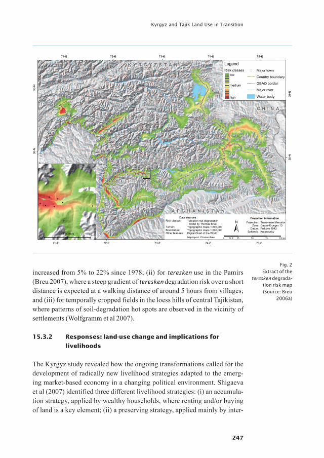
The fourth study focused on the provincial scale, on the Gorno Badakhshan Autonomous Oblast (GBAO), Tajikistan (Figure 1). The aim was to model the degradation risk for teresken, a shrubby vegetation which in the Pamirs is nowadays extensively used as a fuel substitute. A spatial fuzzy logic-based modelling approach applied to an expert-based classification tree was adopted. This approach has so far been applied mainly at a smaller scale (e.g. global resource assessments). In this study, the approach was further devel-oped for application at the village level. The study was intended to investi-gate knowledge about land resources available at different stakeholder lev-els and to address its role in SLM (Breu 2006a).
Fig. 1 Map of Central
Asia and the four Swiss National
Centre of Compe-tence in Research
(NCCR) North-South study sites.
(Map by Bettina Wolfgramm)
Global Change and Sustainable Development
246
North-Southperspectives
15.3 Results:responsesandopportunitiesforSLM
This section presents results related to responses to the challenges created in the transformation context and highlights opportunities for SLM in the same context. Additionally, a summary of the lessons learned from the different methodological approaches applied in the specific Central Asian context is provided in section 15.3.4.
15.3.1 Responses:thecurrentstateoflandresourcesresulting
fromland-usechanges
Today in Central Asia the situation generally reported is one of widespread and severe land degradation (Sadikov 1999). The results of the four studies presented here confirm ongoing land degradation in many places. However, this understanding must be refined, as spatial variability is high and vari-ous examples of well-conserved land resources do exist. This is demonstrat-ed especially in the two studies from the Tajik loess hills (Akhmadov and Nekushoeva 2007; Wolfgramm et al 2007).
Newly collected empirical data on the state of land resources show that in the loess region of central Tajikistan large areas are affected by water ero-sion, with 45% of the study area classified as showing indications of erosion (Wolfgramm et al 2007). In the Sokuluk basin in Kyrgyzstan, forage produc-tivity on pre-mountain and mountain pastures close to villages has generally decreased between 1% and 34% since 1978 (Shigaeva et al 2007). Based on the teresken degradation risk model it was calculated that teresken areas with a low, medium or high degradation risk cover a total of roughly 30% (or 19,000 km2) of the surface of GBAO (Breu 2006a; Figure 2). Howev-er, by contrast with this negative picture, classification of the loess areas in Tajikistan showed that 33% of the area classified was well conserved (Wolf-gramm et al 2007).
All four studies showed that severe management problems and the related depletion of natural resources today seem to be linked to the fact that the financial, human and physical resources of farmers are very limited. Thus, the intensity of use of these natural resources today is closely linked to the accessibility of areas and their vicinity to villages. This effect was observed for different land-use types: (i) for pasture use in the Pamirs (Haslinger et al 2007) and in Kyrgyzstan (Shigaeva et al 2007), where use of remote high-mountain pastures was abandoned and where forage productivity has
247
Kyrgyz and Tajik Land Use in Transition
increased from 5% to 22% since 1978; (ii) for teresken use in the Pamirs (Breu 2007), where a steep gradient of teresken degradation risk over a short distance is expected at a walking distance of around 5 hours from villages; and (iii) for temporally cropped fields in the loess hills of central Tajikistan, where patterns of soil-degradation hot spots are observed in the vicinity of settlements (Wolfgramm et al 2007).
15.3.2 Responses:land-usechangeandimplicationsfor
livelihoods
The Kyrgyz study revealed how the ongoing transformations called for the development of radically new livelihood strategies adapted to the emerg-ing market-based economy in a changing political environment. Shigaeva et al (2007) identified three different livelihood strategies: (i) an accumula-tion strategy, applied by wealthy households, where renting and/or buying of land is a key element; (ii) a preserving strategy, applied mainly by inter-
75∞E
75∞E
74∞E
74∞E
73∞E
73∞E
72∞E
72∞E
71∞E
71∞E
39∞N
39∞N
38∞N
38∞N
0 25 50 75 10012.5 km
K Y R G Y Z S T A NK Y R G Y Z S T A N
C H I N AC H I N A
Projection informationProjection:
Zone:Datum:
Spheroid:
Transverse MercatorGauss-Krueger 13Pulkovo 1942Krassovsky
Data sourcesRisk classes:
Terrain:Boundaries:Other features:
Teresken risk degradation model by Thomas BreuTopographic maps 1:200,000Topographic maps 1:200,000Digital Chart of the WorldMap layout: Thomas Breu
±A F G H A N I S T A NA F G H A N I S T A N
!
!
!
!
!
!!
Legend!( Major town
Country boundary
GBAO border
Major river
Water body
Risk classeslow
high
medium
0 10Kilometers
Vanch
Darva
z
Bartang
Wakhan
Gunt
Shakhdara
Pan
dzh
river
Fig. 2 Extract of the
teresken degrada-tion risk map (Source: Breu
2006a)

Global Change and Sustainable Development
248
North-Southperspectives
mediate households, which are very often forced to return their land to the commune or sell it to wealthier households; (iii) a coping strategy, applied mainly by poor households consisting of elderly pensioners or headed by single mothers, whose agricultural production is very low and barely covers subsistence needs due to their limited labour and economic power; pensions and social allowances form the backbone of these households’ income. The study showed that in the study areas the main avenues for rural families to increase their wealth are to be found in the agricultural sector and consist in controlling more and mainly irrigated land, as well as in increasing live-stock. Ensuring access to land for the poor is therefore imperative to combat rural poverty and socio-economic disparities in rural Kyrgyzstan.
15.3.3 Opportunities:examplesofSLM
The Tajik study conducted at the regional level showed that various oppor-tunities for SLM in the loess hills of Tajikistan exist and include specifically the following land-use systems: (i) fruit, cereal and fodder plots, either tra-ditionally cultivated or newly established; (ii) large-area conservation sys-tems implemented in Soviet times and diversified into agroforestry systems during the 1990s; and more recently, (iii) agronomic conservation measures on farm cropland, such as crop rotation and cultivation of perennial fodder (Wolfgramm et al 2007).
In the Tajik study conducted at the local level, a significant impact of con-servation measures, especially on organic matter content in the topsoil, was detected in a case study in Varzob. In this area, slopes of around 30% are used communally and are heavily overgrazed, resulting in reduced vegeta-
Fig. 3 Degrading and well-conserved areas, Faizabad, Tajikistan. (Photo by Gulniso Nekushoeva, 2006)

249
Kyrgyz and Tajik Land Use in Transition
tion cover and severe sheet and rill erosion. Already in 1982, an innovative land user began to set up a half-hectare vineyard/fruit plot with intensive grass/fodder production for cut-and-carry use (Liniger and Critchley 2007). Today this management practice has led to distinct differences in the con-tent of soil organic matter, with an organic matter content of over 1.5% to over 2% in conserved areas, as opposed to less than 1.5% in degraded areas (Akhmadov and Nekushoeva 2007).
Nekushoeva also found that even degraded areas have a potential to be used for agricultural production when adequately managed – such as degraded pasture areas when fenced in and cultivated with alfa-alfa. While soil prop-erties in such areas change slowly and inconsistently, productivity rapidly increases several times over (Akhmadov and Nekushoeva 2007).
15.3.4 Summarisingmethodologicalexperiences
Analysis of the above studies led to three types of conclusions regarding the application of more efficient methods for assesing land degradation and conservation in Central Asia:
Research questions and required spatial scales: Comparison of the stud-ies described above highlights differences in the availability of data and the feasibility of specific analyses for each scale. At the provincial scale (1:500,000), data are highly generalised and often remotely sensed; expert-knowledge-based classification models might be applied, but ground-truth information for verification is often scarce. Thus, such coarse information is mainly indicative and suitable for preliminary analysis of risks and/or oppor-tunities. At the district scale (1:50,000), collection of representative field data is feasible and can be used to calibrate remotely sensed data. Resulting maps provide information on the state of resources and are also useful for monitoring. However, the level of generalisation of the data is high, allow-ing mainly for qualitative analysis with regard to the effect of land use on natural resources, e.g. soil. Case studies (1:5000) allow for sampling of well-defined, homogenous areas at a high density, and thus facilitate controlling of influencing factors. This allows for quantitative impact assessments.
Classification tree modelling – successful approaches for spatial assess-ments in heterogeneous areas: Today, spatial datasets are readily acces-sible, e.g. in the form of satellite images. However, highly heterogeneous areas are challenging with regard to satellite image classification. In the pre-

Global Change and Sustainable Development
250
North-Southperspectives
vious section, two studies were mentioned that included different types of tree models: (i) an expert-knowledge-based classification tree model com-bined with fuzzy logics (Breu 2006b) and (ii) a modelling approach based on statistical algorithms (Wolfgramm et al 2007). Classification tree models are non-parametric and thus provide a well-suited approach for heteroge-neous areas. Further advantages are straightforward integration of various datasets and linking of rules observed in the field with models.
Collaboration between land users and scientists (transdisciplinary approaches): The results from the interviews conducted with farmers using the WOCAT questionnaires showed that farmers’ knowledge is deci-sive for planning SLM. While researchers are better equipped to verify and quantify processes, land users provide crucial information regarding land management and degradation and conservation processes (Akhmadov and Nekushoeva 2007). Thus, there is great potential in concurrently applying transdisciplinary approaches and disciplinary scientific methods. Further-more, the results of the study by Breu (2006a) show that on average, knowl-edge of SLM at different stakeholder levels differs little, while differences within a stakeholder level can be considerable. These experiences confirm the importance of exchange among stakeholders, also within the individual stakeholder levels, in order to share knowledge about SLM and to negotiate and coordinate actions.
15.4 Conclusionsandimplications
This section draws conclusions and provides recommendations for future research. Based on the synthesis at hand, the following three aspects were considered of crucial importance in creating opportunities for SLM in Kyr-gyzstan and Tajikistan:
Information basis for land-use planning: Approaches were identified and applied to efficiently collect information on the state of land resources at different scales relevant to land-use planning. Today geographic informa-tion systems (GIS), remote sensing and efficient laboratory methods play an important role in mapping. Studies have shown that transdisciplinary approaches for identifying SLM options at the plot level are decisive. Thus, participatory (GIS) approaches should be used also for land-use planning and monitoring activities at the district and provincial levels.
251
Kyrgyz and Tajik Land Use in Transition
Abandonment of agricultural plots: This phenomenon has been observed to be linked to widespread labour migration. While in some cases abandon-ment of cultivation can take pressure off the land, heavily degraded fallow land can also degrade further when abandoned. However, with rising food prices9 it is expected that crop production on marginal land will increase again. As labour migration is very important for both Tajikistan and Kyr-gyzstan, it is recommended that research be conducted on the effect of migration and the availability of human resources, on abandonment of cul-tivation and its effect on land degradation and conservation, as well as on SLM options adapted to households with a limited workforce.
Pasture management: Results show that large areas are used as pastures and that increasing the number of livestock is one of the main options for rural families to increase their wealth. However, easily accessible pastures in particular are highly affected by degradation processes. At the same time, land regulations regarding pastures show distinct deficiencies, for exam-ple regarding clear administrative responsibilities. Although the studies presented here identify various entry points to SLM, they focus mainly on the management of small plots, whereas opportunities for improved pas-ture management are lacking. Thus, there are many implications for future research in the field of pasture management. For Kyrgyzstan, important new topics and research questions have already been identified. They include transhumance to summer pastures, improved pasture and livestock manage-ment (e.g. pasture information systems), and pasture law, including the role of different institutions in land management as well as human and animal health risks.
Global Change and Sustainable Development
252
North-Southperspectives
Endnotes
Full citation for this article:Wolfgramm B, Shigaeva J, Nekushoeva G, Bonfoh B, Breu T, Liniger HP, Maselli D. 2010. Kyrgyz and Tajik land use in transition: Challenges, responses and opportunities. In: Hurni H, Wiesmann U, editors; with an international group of co-editors. GlobalChangeandSustainableDevelopment:
ASynthesisofRegionalExperiencesfromResearchPartnerships.Perspectives of the Swiss National Centre of Competence in Research (NCCR) North-South, University of Bern, Vol. 5. Bern, Switzerland: Geographica Bernensia, pp 241–254.
Acknowledgements:Investigations of the various studies synthesised in this article were supported by the Swiss National Centre of Competence in Research (NCCR) North-South. We thank Inam-ur-Rahim and Joldosh-bek Kasymbekov for their contributions during the synthesis workshop that took place on 13−15 September 2007 in Bishkek, Kyrgyzstan.
1 Bettina Wolfgramm is a Senior Research Scientist at the Centre for Development and Environment (CDE), University of Bern. Her main field of expertise is geographic information systems (GIS) and remote sensing applications for regional land-cover and soil monitoring. One of her special interests is the identification of multi-scale indicators using soil reflectance spectrometry. E-mail: [email protected]
2 Jyldyz Shigaeva is a Senior Researcher at the Institute of Mountain Physiology, National Academy of Sciences of the Kyrgyz Republic. Her main scientific fields of expertise and interest are moun-tain ecology, land use and rural livelihoods. E-mail: [email protected]
3 Gulniso Nekushoeva is a Senior Researcher at the Tajik Soil Institute in Dushanbe, Tajikistan. She has been involved in soil mapping for over 20 years. In the past few years she has been focusing on comparative case studies aiming at assessing the impact of sustainable land management systems using both participatory and quantitative methods. E-mail: [email protected]
4 Bassirou Bonfoh is a veterinarian and Director General of the Centre Suisse de Recherches Scientifiques (CSRS) in Abidjan, Côte d’Ivoire, as well as Regional Coordinator for the Swiss National Centre of Competence in Research (NCCR) North-South in West Africa. He is involved in international research networks in the fields of epidemiology of zoonotic diseases in pastoral production systems. He has a specific interest in expanding the “one health” concept in academic and research institutions in Africa. E-mail: [email protected]
5 Thomas Breu has a PhD in Geography with minors in Economy and Geology. Thomas Breu has over 10 years of experience in developing and transition countries in Southeast Asia and Central Asia. Besides his various coordinating roles, e.g. as Programme Coordinator of the Swiss Na-tional Centre of Competence in Research (NCCR) North-South, he has an extensive track record of publications on geographic information systems (GIS), watershed management, sustainable land management and participatory strategy development. E-mail: [email protected]

253
Kyrgyz and Tajik Land Use in Transition
6 Hanspeter Liniger is a Senior Research Scientist at the Centre for Development and Environ-ment (CDE), University of Bern, and Programme Coordinator of WOCAT (World Overview of Conservation Approaches and Technologies). His professional focus is on evaluation of natural resource management (soil and water conservation) and its local and regional impacts on water and soil productivity; dryland management; and training of professionals and supervision of students. E-mail: [email protected]
7 Daniel Maselli is Senior Research Scientist at the Centre for Development and Environment (CDE), University of Bern, Switzerland, and Associate Senior Research Fellow at the University of Central Asia (UCA) in Bishkek, Kyrgyzstan. His main field of expertise is natural resource use in semi-arid mountain regions with a particular focus on transhumance and sustainable pasture management. He recently joined the Swiss Agency for Development and Cooperation (SDC). E-mail: [email protected], [email protected]
8 WOCAT: World Overview of Conservation Approaches and Technologies9 http://enews.ferghana.ru/article.php?id=2124
Global Change and Sustainable Development
254
North-Southperspectives
References
Publications elaborated within the framework of NCCR North-South research are indicated by an asterisk (*).
* Akhmadov HM, Nekushoeva G. 2007. The main SLM methods in rainfed areas [in Russian]. AgriculturalAcademyReportsJournal 14(4):37–44.
Bloch P. 2002. AgrarianReforminUzbekistanandOtherCentralAsianCountries. Working Paper No. 49. Madison, WI: University of Wisconsin, Madison, Land Tenure Center.
* Breu T. 2006a. SustainableLandManagementintheTajikPamirs:TheRoleofKnowledgeforSustainableDevelopment [PhD dissertation]. Bern, Switzerland: Swiss National Centre of Competence in Research (NCCR) North-South and Centre for Develop-ment and Environment (CDE), University of Bern. Also available at: http://www.nccr-north-south.unibe.ch/publications/Infosystem/On-line%20Doku-mente/Upload/PhD%20Breu-SLM%20Pamirs_2006.pdf; accessed on 23 July 2009.
* Breu T. 2006b. Spatial environmental risk modelling in the Pamir-Alai Mountains: Applica-tion of a fuzzy-logic based GIS approach. In:ProceedingsoftheInternationalDisasterReductionConference(IDRC),Davos,27August–1September,2006. Davos, Switzer-land: Swiss Federal Research Institute, pp 705−708.
DFID [Department for International Development]. 2000. SustainableLivelihoodsGuidanceSheets. London: Department for International Development.
Dudwick N, Gomart E, Marc A. 2003. WhenThingsFallApart:QualitativeStudiesofPovertyintheFormerSovietUnion. Washington, D.C.: World Bank.
* Haslinger A, Breu T, Hurni H, Maselli D. 2007. Opportunities and risks in reconciling con-servation and development in a post-Soviet setting: The example of the Tajik Nation-al Park. InternationalJournalofBiodiversityScienceandManagement 3(3):157−169.
Hurni H. 2000. Assessing sustainable land management (SLM). AgricultureEcosystems&Environment 81:83−92.
Jones KD. 2004. Land privatization and conflict in Central Asia: Is Kyrgyzstan a model? In:Burghart D, editor. IntheTracksofTamerlane:CentralAsia’sPathtothe21stCentury. Washington, D.C.: National Defense University, Center for Technology and National Security Policy (CTNSP), pp 258−272.
Kyrgyz Giprozem [Kyrgyz State Institute for Land Management Planning]. 1987. Methodo-logicalGuidelinestoConductGeobotanicalResearchonNaturalFodderLandsoftheKyrgyzSSR [in Russian]. Bishkek, Kyrgyzstan: Kyrgyz Giprozem.
Liniger HP, Critchley W, editors. 2007. WheretheLandIsGreener:CaseStudiesandAnaly-sisofSoilandWaterConservationInitiativesWorldwide.Bern, Switzerland: World Overview of Conservation Approaches and Technologies (WOCAT), CTA, Food and Agriculture Organization of the United Nations (FAO), United Nations Environment Programme (UNEP), and Centre for Development and Environment (CDE).
* Ludi E. 2003. Sustainable pasture management in Kyrgyzstan and Tajikistan: Development needs and recommendations. MountainResearchandDevelopment 23(2):119−123.
Nissen SW. 2004. Tajiks’ promised land − A farm of one’s own. OSCEMagazine 1(3):4−7.
Sadikov KR, editor. 1999. MountainRegionsofCentralAsia−SustainableDevelopmentIssues.Dushanbe, Tajikistan: Tajik Technical University.
Shepherd KD, Walsh MG. 2002. Development of reflectance spectral libraries for characteri-zation of soil properties. SoilScienceSocietyofAmericaJournal 66:988−998.
* Shigaeva J, Kollmair M, Niederer P, Maselli D. 2007. Livelihoods in transition: Changing land use strategies and ecological implications in a post-Soviet setting (Kyrgyzstan). CentralAsianSurvey 26(3):389−406.
* Wolfgramm B, Seiler S, Kneubühler M, Liniger HP. 2007. Spatial assessment of erosion and its impact on soil fertility in the Tajik foothills. EARSeLeProceedings 6(1):12−25.
Zaslavski MN. 1983. StudyingSoilErosion [in Russian]. Moscow, Russia: Mysl.