15. CONSIDERATION OF ACCEPTANCE OF DRAINAGE EASEMENT ...
8
SOUTHAMPTON COUNTY BOARD OF SUPERVISORS Regular Session i October 27, 2014 MOTION REQUIRED: A motion is required authorizing the County Administrator to accept the attached Deed of Easement, subject to approval as to form by the County Attorney. 15. CONSIDERATION OF ACCEPTANCE OF DRAINAGE EASEMENT COUNTRY ROADS SUBDIVISION In May of 2008, the developers of Phase 2 of the Country Roads subdivision (north of Story’s Station) recorded a revised plat which relocated the property line between lot(s) 6 and 7 and centered a 20’ drainage easement along the revised lot line. A copy is attached herewith for your reference. However, the final grading did not direct the flow of stormwater to the easement between the lots, but allowed it to continue to follow its natural path along the eastern edge of lot 6. To resolve this situation, the owner of lot 6 has agreed to set aside an additional 40’for a public drainage easement; the total area within the easement is 0.214 acres. Attached herewith please find a copy of the proposed deed of easement and an exhibit illustrating the easement. If the Board is agreeable, a motion is required authorizing the County Administrator to accept the Deed of Easement, subject to Approval as to Form by the County Attorney.
Transcript of 15. CONSIDERATION OF ACCEPTANCE OF DRAINAGE EASEMENT ...

SOUTHAMPTON COUNTY BOARD OF SUPERVISORS Regular Session i October 27, 2014
MOTION REQUIRED: A motion is required authorizing the County Administrator to accept the attached Deed of Easement, subject to approval as to form by the County Attorney.
15. CONSIDERATION OF ACCEPTANCE OF DRAINAGE EASEMENT COUNTRY ROADS SUBDIVISION
In May of 2008, the developers of Phase 2 of the Country Roads subdivision (north of Story’s Station) recorded a revised plat which relocated the property line between lot(s) 6 and 7 and centered a 20’ drainage easement along the revised lot line. A copy is attached herewith for your reference. However, the final grading did not direct the flow of stormwater to the easement between the lots, but allowed it to continue to follow its natural path along the eastern edge of lot 6. To resolve this situation, the owner of lot 6 has agreed to set aside an additional 40’for a public drainage easement; the total area within the easement is 0.214 acres. Attached herewith please find a copy of the proposed deed of easement and an exhibit illustrating the easement. If the Board is agreeable, a motion is required authorizing the County Administrator to accept the Deed of Easement, subject to Approval as to Form by the County Attorney.
r
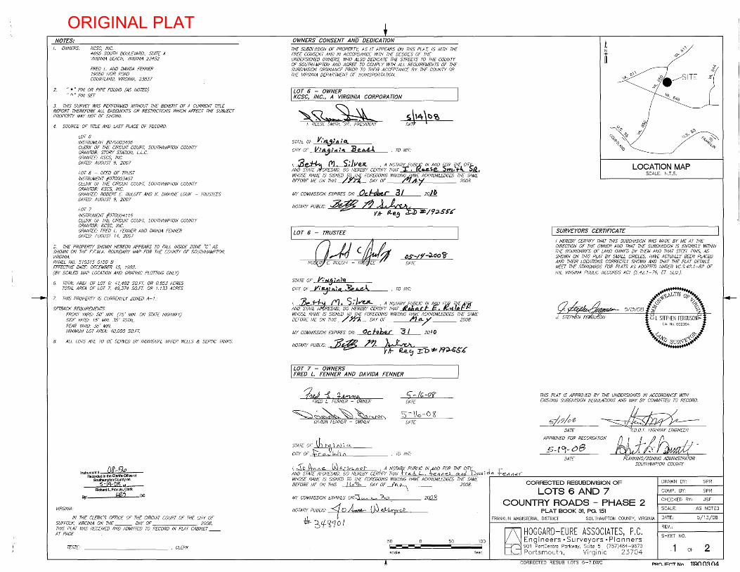
NOTES: OWNERS: KCSC, INC.
4665 SOUTH BOULEVARD., SUITE A VIRGINIA BEACH, VIRGINIA 23452
FRED L. AND DAVIDA FENNER 19050 IVOR ROAD COURTLAND, VIRGINIA, 23837
2. ... " PIN OR PIPE FOUND (AS NOTED) .. 0" PIN SET
3. THIS SURVEY WAS PERFORMED WITHOUT THE BENEFIT OF A CURRENT TITLE REPORT THEREFORE ALL EASEMENTS OR RESTRICTIONS WHICH AFFECT THE SUBJECT PROPERTY MAY NOT BE SHOWN.
4. SOURCE OF TITLE AND LAST PLACE OF RECORD:
LOT 6 INSTRUMENT 1070003406 CLERK OF THE CIRCUIT COURT, SOUTHAMPTON COUNTY GRANTOR: STORY STATION, L.L.C. GRANTEE: KSCS, INC. DATED: AUGUST 9, 2007
LOT 6 - DEED OF TRUST INSTRUMENT 1070003407 CLERK OF THE CIRCUIT COURT, SOUTHAMPTON COUNTY GRANTOR: KSCS, INC. GRANTEE: ROBERT E RULOFF AND K. DWA YNE LOUK - TRUSTEES DATED: AUGUST 9, 2007
LOT 7 INSTRUMENT 1070004116 CLERK OF THE CIRCUIT COURT, SOUTHAMPTON COUNTY GRANTOR: KCSC, INC. GRANTEE' FRED L. FENNER AND DAVIDA FENNER DATED: AUGUST 14, 2007
5. THE PROPERTY SHOWN HEREON APPEARS TO FALL INSIDE ZONE "C" AS SHOWN ON THE F.EM.A. BOUNDARY MAP FOR THE COUNTY OF SOUTHHAMPTON, VIRGINIA. PANEL NO. 510315 0150 B EFFECTIVE DATE: DECEMBER IS, 19B2. (BY SCALED MAP LOCATION AND GRAPHIC PLOTTiNG ONLY)
6. TOTAL AREA OF LOT 6: 41,492 SO.FT. OR 0.953 ACRES TOTAL AREA OF LOT 7: 49,374 SO.FT. OR 1.133 ACRES
7. THIS PROPERTY IS CURRENTLY ZONED A-I.:
SETBACK REQUIREMENTS FRONT YARD: 50' MIN. (75' MIN. ON STATE HIGHWAY) SIDE YARD: IS' MIN. 35' TOTAL. REAR YARD: 35' MIN. MINIMUM LOT AREA: 40,000 SO.FT.
B. ALL LOTS ARE TO BE SERVED BY INDIVIDUAL WATER WELLS & SEPTIC TANKS.
VIRGINIA:
Instrument#~ Recorded In the Clerk'S Office of
SOuthampton County on 5-ltj-Q?j at __
Richard L Francis, Clerk
By: ~? DC
IN THE CLERK'S OFFICE OF THE CIRCUIT COURT OF THE CITY OF SUFFOLK, VIRGINIA ON THE DA Y OF 200B, THIS PLAT WAS RECEIVED AND ADMITTED TO RECORD IN PLAT CABINET AT PAGE
TESTE' ___________ , CLERK
OWNERS CONSENT AND DEDICATION
THE SUBDIVISION OF PROPERTY, AS IT APPEARS ON THIS PLA T, IS WITH THE FREE CONSENT AND IN ACCORDANCE WITH THE DESIRES OF THE UNDERSIGNED OWNERS, WHO ALSO DEDICA T£ THE STREETS TO THE COUNTY OF SOUTHAMPTON AND AGREE TO COMPL Y WITH ALL REOUIREMENTS OF THE SUBDIVISION ORDINANCE PRIOR TO THEIR ACCEPTANCE BY THE COUNTY OR THE VIRGINIA DEPARTMENT OF TRANSPORTA TlON.
CORPORATION
'5. \'4 \~«O DAT!
STATE OF Y.·~I'" ,'q,
CITY OF V.,4.."",, ~1. BeALl , TO WIT.'
I, oDP-~ (YJ ;,; /Ve.1l. , A NOTARY PUB~ IN AND /)JR (HE CITt-AND STAiEORESAID, DO HEREBY CERTIFY THAT r .a.e.se.. ::>m. t4:. :>12, WHOSE NAME IS SIGNED ;r;,,!!!.[ FOREGOING WRITIN~ VE ACKNOWLEDGED THE SAME BEFORE ME ON THIS , DAY OF ~ 'I 200B.
MY COMMISSION EXPIRES ON: 0" I-dbe.r a I 201 b
NOTARY PUBLIC: $~ l"'1 ~1 VH- #t.e.., J) lJ;/9:J-SS'J{
STATE OF J;"·I<l.jI'I1~q
CITY OF y.,~:h.~~ J?"'Ju!A
!)$'-/f-J.(JO cgDATE
, TO WIT:
I, 'be 'I-'I--fJ C1.. 5.-JvUf- ,A NOTARY PUBLIC IN Afj/J F~ T"E Alif" AND STATE A RESAID, DO HEREBY CERTIFY THAT IltJbe r r i:=. /C .... lo f" f.!. WHOSE NAME IS SIGNED TO THE FOREGOING WRITING HAVE ACKNOWLEDGED THE SAME BEFORE ME ON THIS ~ DAY OF t'1 a... V 200B.
7
20~ MY COMMISSION EXPIRES ON: OC hb~ 3 I
NOTARY PUBLIC: :Jf~ ;n;.. ~, r.+- R..e..c.J X'D './;:: J9';)...SS'£
LOT 7 - OWNERS FRED L. FENNER AND DA VIDA FENNER
1tUJ -i. q.~tA . FRED L. FENNER -- OWNER
~~,>-~~~No,~ DAVIDA FENNER - OWNER
STATE or th t~ ~ Ni a...
CITY OF £c 00 kl. {\
c; ~/r;~oC(' DATE
S~\\o-o~ DATE
, TO WIT:
~ t
U
'0\\ '-Ii"
'0"
C'Q~d' 'i> " 1
'11-0
,J? <0
-"~
",<' ",~.
-,,~f.---Sl TE
V-,!. 619
<:,'0 \J?'
LOCATION MAP SCALE: N.T.S.
I SURVEYORS CERTIFICA TE
'" cri ~
"'0> 1'-;:::::' -1",0
'i(q..
I HEREBY CERTIFY THAT THIS SUBDIVISION WAS MADE BY ME AT THE DIRECTION OF THE OWNER AND THAT THE SUBDIVISION IS ENTIREL Y WITHIN THE BOUNDARIES OF LAND OWNED BY THEM AND THAT STEEL PINS, AS SHOWN ON THIS PLAT BY SMALL CIRCLES, HAVE ACTUALLY BEEN PLACED AND THEIR LOCATIONS CORRECTLY SHOWN AND THAT THE PLAT DETAILS MEET THE STANDARDS FOR PLATS AS ADOPTED UNDER VC.S.42.1-B2 OF THE VIRGINIA PUBLIC RECORDS ACT (5.42.1-76, IT. SEO.).
THIS PLAT IS APPROVED BY THE UNDERSIGNED IN ACCORDANCE WITH EXISTING SUBDIVISION REGULATIONS AND MAY BY COMMITTED TO RECORD .
5/;9106 DATE
APPROVED FOR RECORDATION
W-).~-5-rDJ-08 DATE
1~~A~W4~A~ ,A~~~~~~~~q~ 'di~jr~~~ _________________ T==~~_~~~ AND STATE AFORESAID, DO HEREBY CERTIFY THAT +-re cl L. 1-cerll1eJL a.nd 1..Ja.~ I i~ -reI! Tiel
WHOSE NAME IS SIGNED TO THE FOREGOING WRITING HAVE ACKNOWLEDGED THE SAME I CORRECTED RESUBDIVISION OF BEFORE ME ON THIS ~ DAY OF "" A-.. \ 2008. LOTS 6 AND 7
PLANNING/ZONING ADMINISTRATOR SOUTHAMPTON COUNTY
DRAWN BY: SPR
COMPo BY: SPR
MY COMMISSION EXPIRES ON:""::' ,. ~o 2Q2B COUNTRY ROADS _ PHASE 2 CHECKED BY: JSF
PLAT BOOK 31, PO. 151 SCALE: AS NOTED NOTARY PUBLIC: <flO ~ (hJ <~ tt- ~c.f-9/70 I FRANKLIN MAGISTERIAL DISTRICT SOUTHAMPTON COUNTY, VIRGINIA DATE: 5/13/08
50 50 Iorro.-___
scale
100
feet ~ HOGGARD-EURE ASSOCIATES, P.C. Engineers' Surveyors· Planners 901 PortCentre Parkway, Suite 5 (757)484-9670 Portsmouth, Virginia 23704
CORRECTED RESUB LOTS 6-7.DWG
REV.:
SHEET NO.
1 OF 2
PR~. II=~T Nn 11!=ln n~ n4
ORIGINAL PLAT

InBtrumentll 'D<? ,5(p Racon:Ied In tha Clerk's 0IfIca of
6,~~u"!_on __ Richard L Manelo, Clerk
By: bUlb DC
~",~o =-~ "0:s:. .... ....
LOT 5 COUNTRY ROADS
PHASE 2 p.B. 31, PGS. 44-47
R ~
n
~
S16' -::-:!.9'0?" .J8.~C
S~~;g:,O', '19 0,>"
'90" ('
TAX PARCEL 61-41 NOW OR FORMERL Y
HOWELL CORPORATION #2 D.B. 232, PG. 64
<§J'~~ \ ,
O:CI~'\.. \'2-:,:1\ 'Clu
•• 5 :
S69'OO'36"E ~:1:l i ! 's 72.73' '2- : ':!
I !! I " I :: I ::! EXISTING PROPERTY I : I : LINE HEREBY VACATED I : r--+--IN ACCORDANCE WITH I :,: VIRGINIA STA TE CODE I :': 15.2-2275
I !! I , : EXISTING 20' PUBLIC
20' PUBLIC I : DRAINAGE EASEMENT DRAINAGE EASEMENT : HEREBY VACATED HEREBY DEDICATED I : IN ACCORDANCE WITH
I • : VIRGINIA STATE CODE
LOT 6 41,492 SO.FT.
0.953 AC.
I ~, 15.2-2265
I ~ : N '
I : I : I ,w :
I .n : I ::::: : I
:- , N ,
I Z :
I : I : I : I : I : I : I ,
LOT 7 49,374 SO.FT.
1.133 AC.
S.)s'
~7J>7'l--"'.)SS·~.s
50' SETBACK I I!:! ------------------------1- ---i------L--:....,----------------I I! I: EXISTING I I:,: 20' COMMON I I:,: I UTILITY EASEMENT
;,.
~
~ n ~ ~
LOTB COUNTRY ROADS
PHASE 2 P.B. 31, PGS. 44-47
I I, I: I P.B. 31, PGS. 44-47 ____________________________ L_ ~-l---L--
I I,"
170.00'
I I:'! I I! :
N68'15'29"W 350.00'
CREEK SiDE LANE (50' R/W) (P.B. 31, PGS. 44-47)
180.00'
313.1' HUNTER POINT RD.
CORRECTED RESUBDIVISION OF
LOTS 6 AND 7 COUNTRY ROADS - PHASE 2
PLAT BOOK 31, PG, 151
DRAWN BY: SPR
COMPo BY: SPR
CHECKED BY: JSF
SCALE: 1"=30'
FRANKLIN MAGISTERIAL DISTRICT SOUTHAMPTON COUNTY, VIRGINIA DATE: 5/13/08
30 30
scale
60
feet ~ HOGGARD-EURE ASSOCIATES, P.C. Engineers. Surveyors· Planners 901 PartCentre Parkway, Suite 5 (757)484-9670
Portsmouth, Virginia 23704
CORRECTED RESUB LOTS 6-7.DWG
REV.:
SHEET NO.
2 OF 2
PRO.JECT No, 1190,03,04
ORIGINAL PLAT
Hoggard-Eure Associates,.c
[N01NEE<l5 SURVEYORS f>l.A"INEAS
757·484·9670 . fax: 757-484 ·7498 901 Po,t(tnlre Porkwav. Suite S Portsmouth. VirQinio 23704
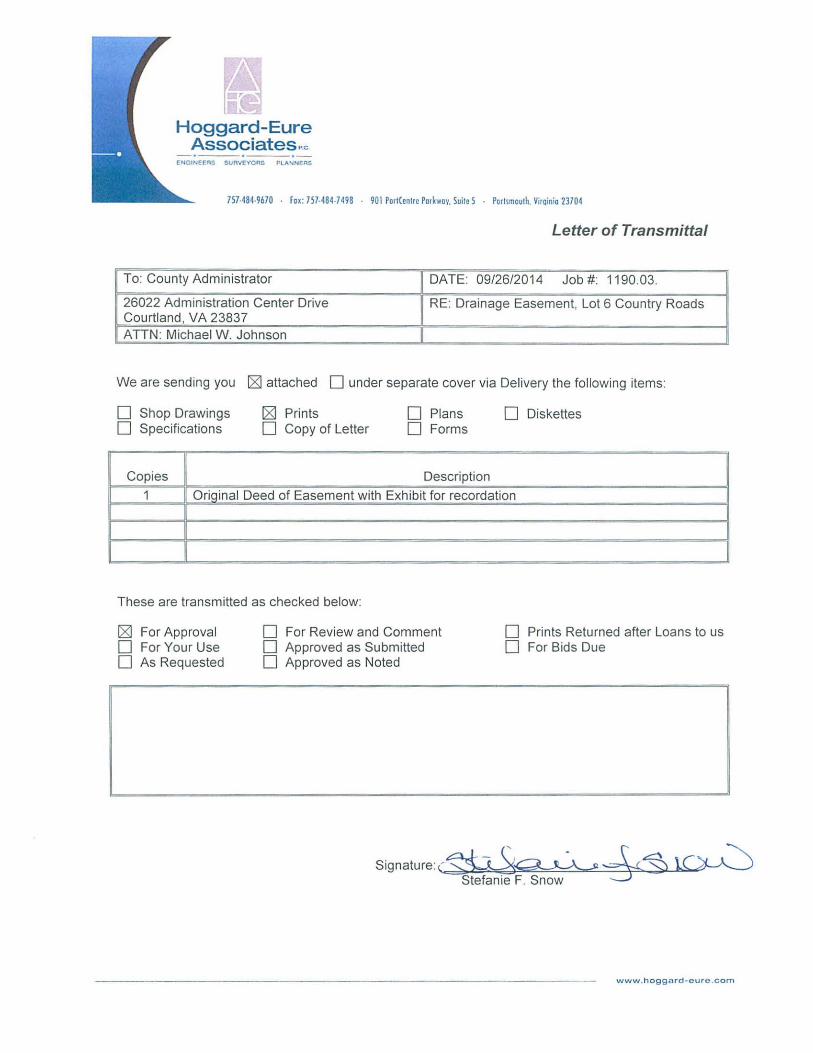
Letter of Transmittal
To: County Administrator DATE: 09/26/2014 Job #: 1190.03.
26022 Administration Center Drive RE: Drainage Easement, Lot 6 Country Roads Courtland, VA 23837 AnN: Michael W. Johnson
We are sending you [gJ attached 0 under separate cover via Delivery the following items:
o Shop Drawings [gJ Prints o Plans o Diskettes o Specifications o Copy of Letter o Forms
Copies Description
1 OrTOinal Deed of Easement with Exhibit for recordation
These are transmitted as checked below:
[gJ For Approval o For Review and Comment o Prints Returned after Loans to us o For Your Use o Approved as Submitted o For Bids Due o As Requested o Approved as Noted
Signature (~~~§ \.C~ Stefanie F. Snow
www .hoggard- eurc .com
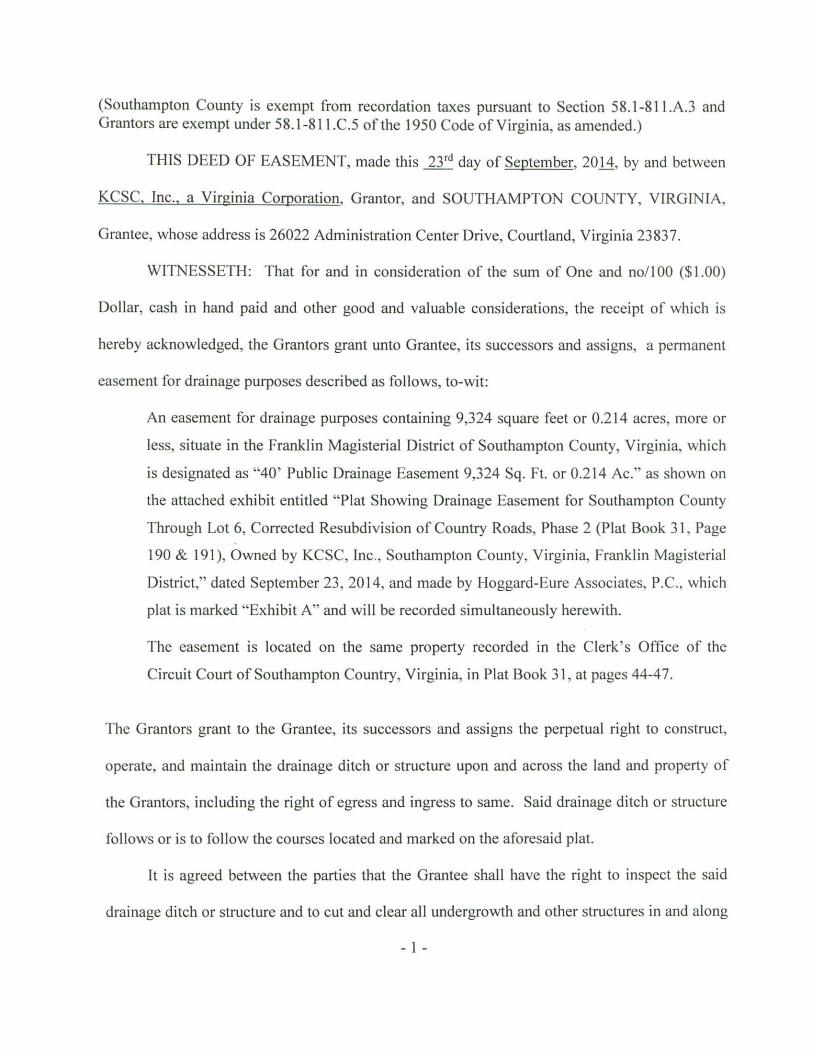
(Southampton County is exempt from recordation taxes pursuant to Section 58 .1-81l.AJ and Grantors are exempt under 58.1-811.C.5 of the 1950 Code of Virginia, as amended.)
THIS DEED OF EASEMENT, made this 23,d day of September, 2011, by and between
KCSC. Inc .. a Virginia Corporation, Grantor, and SOUTHAMPTON COUNTY, VIRGINIA,
Grantee, whose address is 26022 Administration Center Drive, Courtland, Virginia 23837.
WITNESSETH: That for and in consideration of the sum of One and nollOO ($1 .00)
Dollar, cash in hand paid and other good and valuable considerations, the receipt of which is
hereby acknowledged, the Grantors grant unto Grantee, its successors and assigns, a permanent
easement for drainage purposes described as follows, to-wit:
An easement for drainage purposes containing 9,324 square feet or 0.214 acres, more or
less, situate in the Franklin Magisterial District of Southampton County, Virginia, which
is designated as "40' Public Drainage Easement 9,324 Sq. Ft. or 0.214 Ac." as shown on
the attached exhibit entitled "Plat Showing Drainage Easement for Southampton County
Through Lot 6, Corrected Resubdivision of Country Roads, Phase 2 (Plat Book 31 , Page
190 & 191), Owned by KCSC, Inc., Southampton County, Virginia, Franklin Magisterial
District," dated September 23 , 2014, and made by Hoggard-Eure Associates, P.C. , which
plat is marked "Exhibit A" and will be recorded simultaneously herewith.
The easement is located on the same property recorded in the Clerk's Office of the
Circuit Court of Southampton Country, Virginia, in Plat Book 31 , at pages 44-47.
The Grantors grant to the Grantee, its successors and assigns the perpetual right to construct,
operate, and maintain the drainage ditch or structure upon and across the land and property of
the Grantors, including the right of egress and ingress to same. Said drainage ditch or structure
follows or is to follow the courses located and marked on the aforesaid plat.
It is agreed between the parties that the Grantee shall have the right to inspect the said
drainage ditch or structure and to cut and clear all undergrowth and other structures in and along
- I -

or adjacent to the said drainage ditch that may in any way endanger or interfere with the proper
use of same.
This conveyance is made expressly subject to all unexpired restrictions, reservations, and
easements of record, if any, constituting constructive notice.
WITNESS the following signatures
~.....;l~~~.i!IoO!::"""..t..L~~i...C!....~(SEAL)
"5s\.(.~'~l~ ~<: .. S~ .. "l~c.. . fSI3.U") , ,
COMMONWEALTH OF VIRGINIA, CITY OF VIRGINIA BEACH, to-wit:
The foregoing instrument bearing date of Dl/ 'J :;; IJ.. 0 \ Y was
acknowledged before me this 8?J day of S~lA!.uK , 001 y., by
" }2p R3..{ Svu i-lA..
ROSALIE PALMER CHILTON NOTARY PUBLIC
Commonwealth of Virginia Reg . #7525758
My Commissien Expires April 30, 2016
My commission expires: April SO,)OI b , Registration No : -1 "5~ <)iSg
APPROVED AS TO FORM: ACCEPTED BY: SOUTHAMPTON COUNTY
BY: ____ ~----------------County Attorney County Administrator
-2-
"" 1
~~ 1 R
~I I <0
" Cl.:::;: "" CC)V,'Vi 1
'-~~ 1
C)G It -.J ct: "'-~ "-"'1 '" P:: I ; t-::C)j s· 1 -c)"'-
I ~ Cl
1
TAX PARCEL 67-47 NOW OR FORMERL Y
HOWELL CORPORATION /2 D.B. 232, PG. 64
LOT 6 CORRECTED RESUBDIVISION or
COUNTRY ROADS, PHASE 2 PH 37, PG. 190. & 191
1 1
~I ,..., "" I ""I
40' PUBLIC I DRAINAGE EASEMENT --....lL.,L-,.£.-.,.<....,L-+-J j-'-J
;;:; 1 9,324 SO.FT. OR \"1 0.214 AC. ~ I
~
I--EXISTING 20.' PUBLIC I DRAINAGE EASEMENT I P.B. 31, PGS 44-47
I 50. ' SETB_M_CK __
~ EXISTING --. ---,-I_-
I 1 [ 20. ' COMMON 1 UTILITY EASEMENT I
l PB. 31, PGS. 44-47 I ------- -- ------------
I : ~~:- 1- - - - - - - - --40.00'~' I
N 68'15'29" W 170.0.0. '
CREEK SIDE LANE (50' R/W) (P.B. 31, PGS 44-47)
REVISED PLAT
MJohnson
Polygon
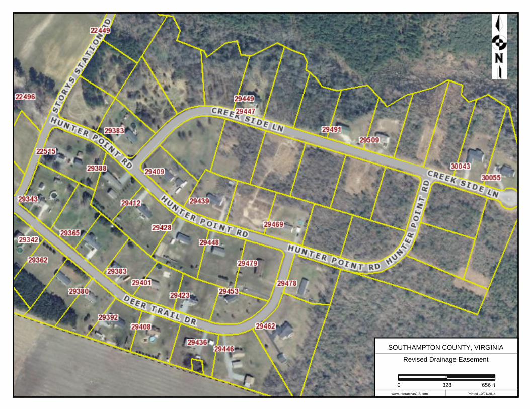
SOUTHAMPTON COUNTY, VIRGINIA
Revised Drainage Easement
www.interactiveGIS.com Printed 10/21/2014
0 328 656 ft
MJohnson
Polygon
MJohnson
Line
MJohnson
Text Box
New Drainage Easement