14.4 St Helena Bay (Refer Plan 37 and Plan 38) 14.4.pdfURBAN DYNAMICS WESTERN CAPE INC. 240 SALDANHA...
8
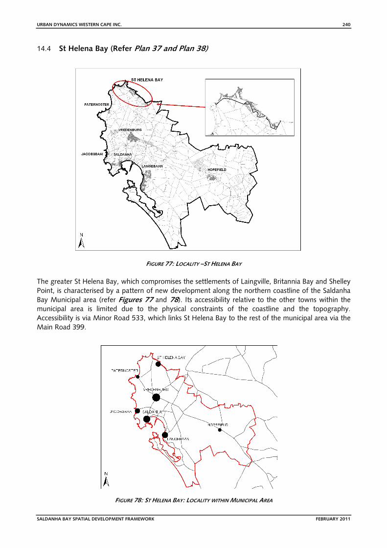
URBAN DYNAMICS WESTERN CAPE INC. 240 SALDANHA BAY SPATIAL DEVELOPMENT FRAMEWORK FEBRUARY 2011 14.4 St Helena Bay (Refer Plan 37 and Plan 38) FIGURE 77: LOCALITY –ST HELENA BAY The greater St Helena Bay, which compromises the settlements of Laingville, Britannia Bay and Shelley Point, is characterised by a pattern of new development along the northern coastline of the Saldanha Bay Municipal area (refer Figures 77 and 78). Its accessibility relative to the other towns within the municipal area is limited due to the physical constraints of the coastline and the topography. Accessibility is via Minor Road 533, which links St Helena Bay to the rest of the municipal area via the Main Road 399. FIGURE 78: ST HELENA BAY: LOCALITY WITHIN MUNICIPAL AREA
Transcript of 14.4 St Helena Bay (Refer Plan 37 and Plan 38) 14.4.pdfURBAN DYNAMICS WESTERN CAPE INC. 240 SALDANHA...
URBAN DYNAMICS WESTERN CAPE INC. 240
SALDANHA BAY SPATIAL DEVELOPMENT FRAMEWORK FEBRUARY 2011
14.4 St Helena Bay (Refer Plan 37 and Plan 38)
FIGURE 77: LOCALITY –ST HELENA BAY
The greater St Helena Bay, which compromises the settlements of Laingville, Britannia Bay and Shelley
Point, is characterised by a pattern of new development along the northern coastline of the Saldanha
Bay Municipal area (refer Figures 77 and 78). Its accessibility relative to the other towns within the municipal area is limited due to the physical constraints of the coastline and the topography.
Accessibility is via Minor Road 533, which links St Helena Bay to the rest of the municipal area via the
Main Road 399.
FIGURE 78: ST HELENA BAY: LOCALITY WITHIN MUNICIPAL AREA
URBAN DYNAMICS WESTERN CAPE INC. 241
SALDANHA BAY SPATIAL DEVELOPMENT FRAMEWORK FEBRUARY 2011
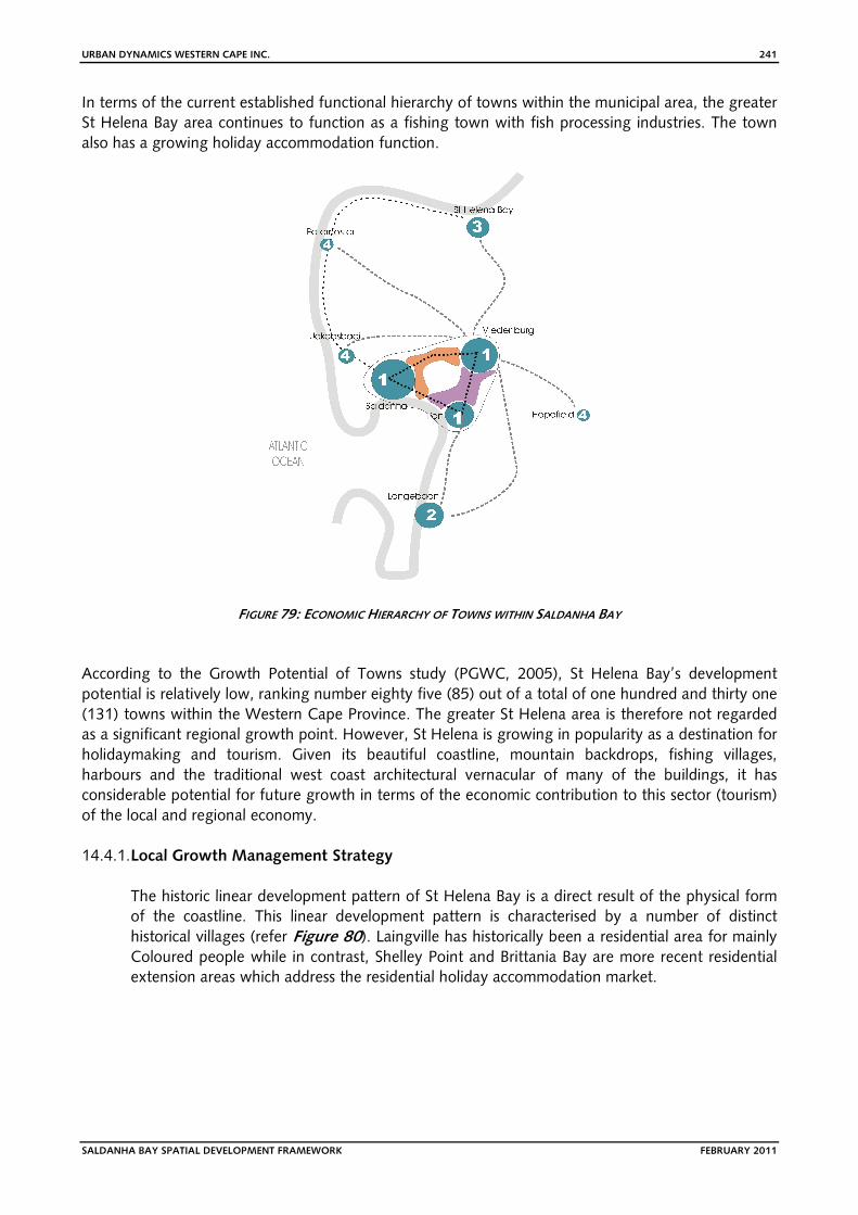
In terms of the current established functional hierarchy of towns within the municipal area, the greater
St Helena Bay area continues to function as a fishing town with fish processing industries. The town
also has a growing holiday accommodation function.
FIGURE 79: ECONOMIC HIERARCHY OF TOWNS WITHIN SALDANHA BAY
According to the Growth Potential of Towns study (PGWC, 2005), St Helena Bay’s development
potential is relatively low, ranking number eighty five (85) out of a total of one hundred and thirty one
(131) towns within the Western Cape Province. The greater St Helena area is therefore not regarded
as a significant regional growth point. However, St Helena is growing in popularity as a destination for
holidaymaking and tourism. Given its beautiful coastline, mountain backdrops, fishing villages,
harbours and the traditional west coast architectural vernacular of many of the buildings, it has
considerable potential for future growth in terms of the economic contribution to this sector (tourism)
of the local and regional economy.
14.4.1. Local Growth Management Strategy
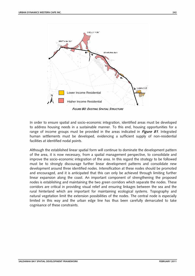
The historic linear development pattern of St Helena Bay is a direct result of the physical form
of the coastline. This linear development pattern is characterised by a number of distinct
historical villages (refer Figure 80). Laingville has historically been a residential area for mainly Coloured people while in contrast, Shelley Point and Brittania Bay are more recent residential
extension areas which address the residential holiday accommodation market.
URBAN DYNAMICS WESTERN CAPE INC. 242
SALDANHA BAY SPATIAL DEVELOPMENT FRAMEWORK FEBRUARY 2011
FIGURE 80: EXISTING SPATIAL STRUCTURE
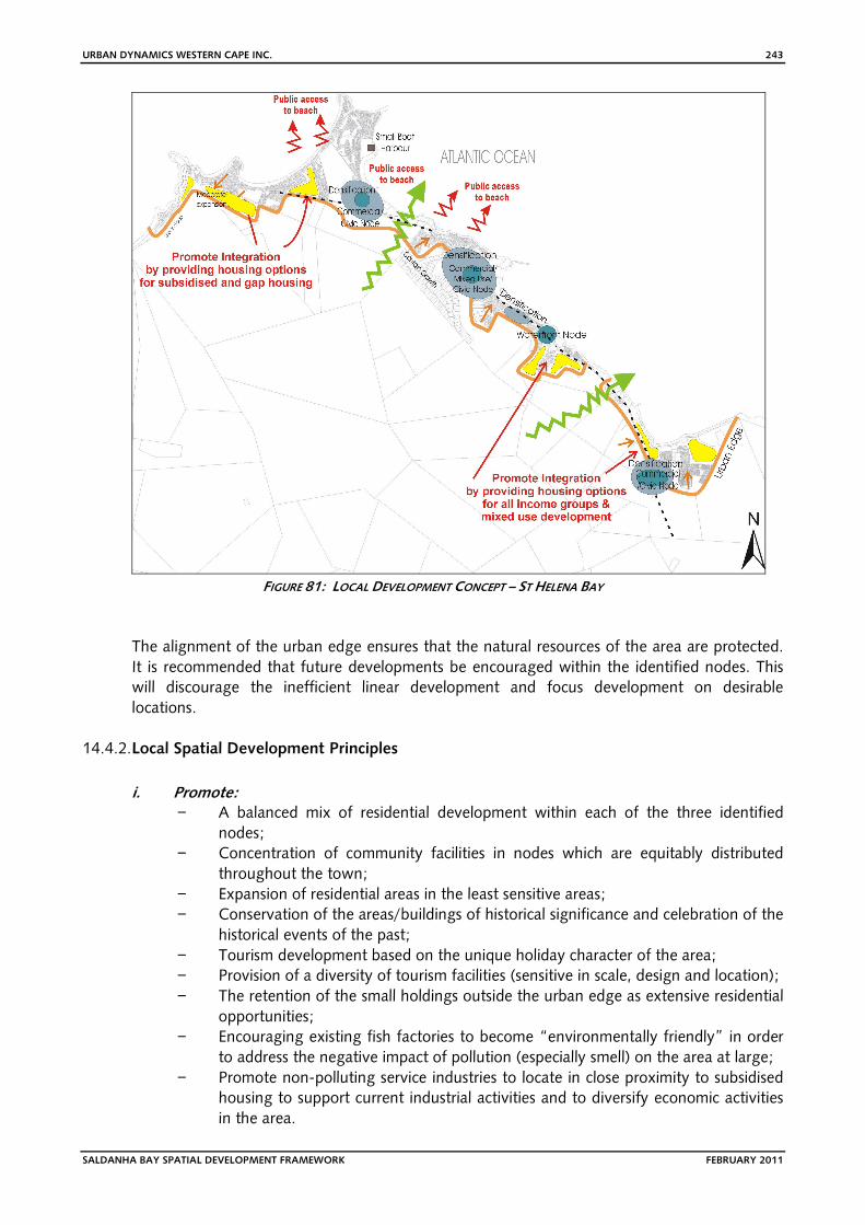
In order to ensure spatial and socio-economic integration, identified areas must be developed
to address housing needs in a sustainable manner. To this end, housing opportunities for a
range of income groups must be provided in the areas indicated in Figure 81. Integrated human settlements must be developed, evidencing a sufficient supply of non-residential
facilities at identified nodal points.
Although the established linear spatial form will continue to dominate the development pattern
of the area, it is now necessary, from a spatial management perspective, to consolidate and
improve the socio-economic integration of the area. In this regard the strategy to be followed
must be to strongly discourage further linear development patterns and consolidate new
development around three identified nodes. Intensification at these nodes should be promoted
and encouraged, and it is anticipated that this can only be achieved through limiting further
linear expansion along the coast. An important component of strengthening the proposed
nodes is establishing and maintaining the two green corridors which separate the nodes. These
corridors are critical in providing visual relief and ensuring linkages between the sea and the
rural hinterland which are important for maintaining ecological systems. Topography and
natural vegetation limit the extension possibilities of the nodes. The central node is especially
limited in this way and the urban edge line has thus been carefully demarcated to take
cognisance of these constraints.
Lower Income Residential
Higher Income Residential
URBAN DYNAMICS WESTERN CAPE INC. 243
SALDANHA BAY SPATIAL DEVELOPMENT FRAMEWORK FEBRUARY 2011
FIGURE 81: LOCAL DEVELOPMENT CONCEPT – ST HELENA BAY
The alignment of the urban edge ensures that the natural resources of the area are protected.
It is recommended that future developments be encouraged within the identified nodes. This
will discourage the inefficient linear development and focus development on desirable
locations.
14.4.2. Local Spatial Development Principles
i. Promote: − A balanced mix of residential development within each of the three identified
nodes;
− Concentration of community facilities in nodes which are equitably distributed
throughout the town;
− Expansion of residential areas in the least sensitive areas;
− Conservation of the areas/buildings of historical significance and celebration of the
historical events of the past;
− Tourism development based on the unique holiday character of the area;
− Provision of a diversity of tourism facilities (sensitive in scale, design and location);
− The retention of the small holdings outside the urban edge as extensive residential
opportunities;
− Encouraging existing fish factories to become “environmentally friendly” in order
to address the negative impact of pollution (especially smell) on the area at large;
− Promote non-polluting service industries to locate in close proximity to subsidised
housing to support current industrial activities and to diversify economic activities
in the area.
URBAN DYNAMICS WESTERN CAPE INC. 244
SALDANHA BAY SPATIAL DEVELOPMENT FRAMEWORK FEBRUARY 2011
ii. Restrict: − Continued ribbon development which is spatially inefficient;
− Privatisation of large stretches of beach thereby depriving the public access
thereto;
− Unchecked linear business development; focus business activities in the identified
nodes;
− The further subdivision of the small holdings and agricultural land outside the
urban edge;
− Residential development which is outside the urban edge and which would lead to
a dispersed development pattern.
iii. Maintain: − Appropriately located parking areas and public access to the beach;
− Significant ecological corridors linking the hinterland with the coast.
iv. Contain:
− The urban footprint of St Helena Bay to within a clearly defined urban edge;
− Business activities to within the identified business nodes;
− Industrial activities to within the existing locations and identified industrial and
service industrial areas.
v. Conserve: − Those buildings with architectural heritage;
− Sensitive vegetation adjacent to the town and on the dunes areas/coastline;
− Important views and ridgelines to minimise the visual impact of development.
14.4.3. Spatial Development Strategies (SDS)
The following spatial development strategies (SDS) are proposed for St Helena Bay:
(i) Equity of Land Use Distribution SDS 1:
Equitable Distribution of Community Facilities
���� The optimal utilisation of community facilities depends on the careful consideration
of their location relative to other land uses and end user thresholds. It is critical
therefore, that the community facilities are located at the identified nodes, or at
other points of highest end user accessibility.
SDS 2:
Integrate Precincts
���� Spatial integration in Laingville must be promoted by (a) the development of a
business precinct at the main entrance to this residential area, and (b) actively
encouraging the development / provision of residential opportunities for all income
groups.
���� Business and community uses should be focused within a well defined hierarchy of
nodes. An equitable distribution of these nodes is important given the linear
development pattern of the town. Refer to Figure 80 for the proposed local
business and community nodes.
URBAN DYNAMICS WESTERN CAPE INC. 245
SALDANHA BAY SPATIAL DEVELOPMENT FRAMEWORK FEBRUARY 2011
(ii) Encouragement / Restriction of Land Use Development SDS 3:
Prevent/contain Ribbon Development
���� It is important to contain further ribbon development along the coast because
sensitive coastal resources are at risk. It is thus important to encourage further
development within the identified nodes.
SDS 4:
Encourage Appropriate Densification
���� Densification, especially within and around the identified nodes, will assist in
preventing sprawling ribbon development. However, due to the linear nature of the
existing development the expansion opportunities for St Helena town are limited.
���� Instead, future growth must be encouraged and accommodated through
appropriate densification strategies.
SDS 5:
Promote tourist related activities
���� An important economic driver and employment creator is the tourist/holiday
accommodation industry. Tourism and related activities must be promoted
wherever possible.
SDS 6:
Contain negative visual impact
���� One aspect which contributes greatly to the unique character of the area is the
uninterrupted hills and “koppies” which punctuate urban development on the
coastal plain. In some instances, insensitive development has led to these ridge lines
being visually interrupted by large, unsightly buildings. In approving new
developments, care should be taken of the visual impact which proposed
developments would have on prominent ridgelines.
14.4.4. Land Use Proposals : Local Planning Level (LPL)
The following Spatial Development Management Proposals are made for St Helena Bay to
address the land use needs identified for the area:
(a) Housing
LPL 1:
Housing needs: Densification and Spatial Expansion
•••• The current average residential density in St. Helena is 12 units per hectare.
However, due to the linear nature of the existing development the expansion
opportunities for St Helena town are limited.
•••• Instead, future growth must encourage appropriate densification strategies.
•••• The projected population growth figures indicate a future residential demand of
approximately 3552 units.
•••• It is within this context that the urban extension areas to St Helena Bay are
proposed.(Refer Plan 38).
•••• Subsidised housing must be provided to address the current housing backlog. In this
regard, sufficient land has been identified for higher density development. To
promote integration, the location of subsidised housing should specifically be
investigated in the proposed north western node.
•••• Care should also be taken to address the “gap” housing market (Households with
incomes of between R3500 and R7000 per month).
URBAN DYNAMICS WESTERN CAPE INC. 246
SALDANHA BAY SPATIAL DEVELOPMENT FRAMEWORK FEBRUARY 2011
(b) Community Facilities
LPL 2:
Provision of Community Facilities
•••• Community facilities must be located within the identified business nodes to ensure
efficient spatial distribution and maximum accessibility. Community facilities and
schools should be provided in residential extension areas in accordance with the
most recent Provincial standards for the provision of community facilities.
LPL 3:
Public Access
•••• An important principle of development along the coast is to ensure public access to
the beach. Existing areas of public access must be retained and maintained, and
retaining public access to the beach must be an important aspect in assessing
township establishment applications.
(c) Business Districts
LPL 4:
Strengthening Local Business Nodes
•••• Businesses serving the local communities must be located within the identified local
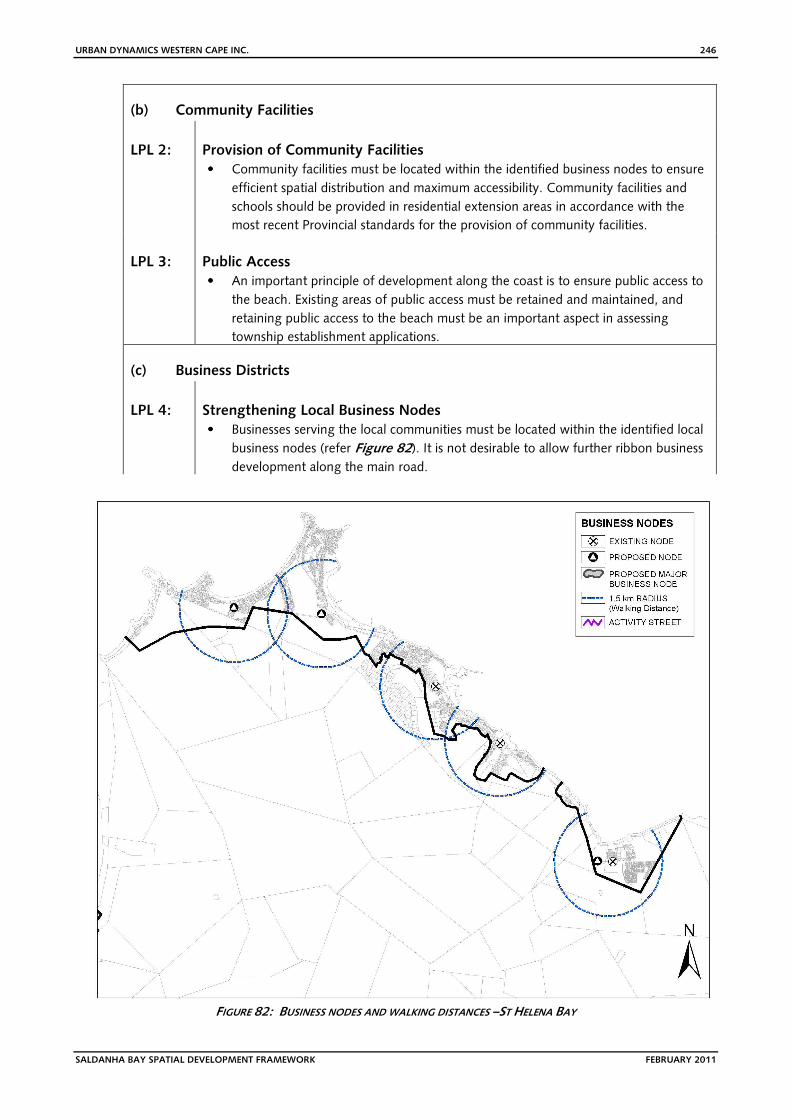
business nodes (refer Figure 82). It is not desirable to allow further ribbon business
development along the main road.
FIGURE 82: BUSINESS NODES AND WALKING DISTANCES –ST HELENA BAY
URBAN DYNAMICS WESTERN CAPE INC. 247
SALDANHA BAY SPATIAL DEVELOPMENT FRAMEWORK FEBRUARY 2011
(d) Industrial
LPL 5:
Provision for the fish processing industry
� Careful provision should be made for the historical fishing industry. New fish
processing industries should be encouraged to implement non-polluting
technologies.
LPL 6:
Service Industrial Development and Community Farming
� A service industrial area has been identified in close proximity to Laingville to
provide opportunities for the diversification of the economy, thus creating jobs for
local residents. Community farming, as well as aquaculture initiatives must also be
investigated and implemented.
(e) Conservation
LPL 7:
Conservation of Sensitive Biophysical Environments
� Sensitive areas of the biophysical environment should be managed with
conservation objectives in mind, and should be protected from urban development.
In this regard, the following areas are of particular importance:
- The areas immediately adjacent to the urban edge in those parts of St Helena
Bay where Saldanha Granite Strandveld occurs.
- The coastline and areas immediately adjacent thereto.
- Any dune systems, particularly any frontal dunes, along the coastline.
- Any CBAs within the urban edge (refer Plan 18).
� The de facto coastal setback line, which is in effect demarcated by the existing
extent (or footprint) of development along the coastline, should be maintained. No
development should be permitted in this de facto setback area along the coastline,
thereby ensuring that a continuous coastal corridor is maintained.
14.4.5. Recommendations
• Encourage residential densification within the identified nodes to limit ribbon
development.
• Encourage development in areas which are not environmentally sensitive.
• Maintain the de facto coastal setback line in accordance with LPL 7. • Provide subsidised housing and ‘gap’ housing to address the needs of the community in
an integrating manner.
• Ensure that development does not have a negative visual impact (especially on ridgelines
and natural vistas).
• Ensure that business and community uses are clustered in nodes which are distributed
equitably throughout the area.
• Discourage inappropriate subdivisions outside the urban edge.