1.3.Vision and principles42.MARITIME PRECINCT PLAN52.1 ... · Web viewPortarlington is home to...
25
Portarlington Safe Harbour Master Plan O V E R V I E W
Transcript of 1.3.Vision and principles42.MARITIME PRECINCT PLAN52.1 ... · Web viewPortarlington is home to...

Portarlington SafeHarbour
MasterPlan
O V E R V I E W
CONTENTS
1.3. Vision and principles 4
2. MARITIME PRECINCT PLAN 5
2.1. Maritime Precinct Plan 4
2.2. Detailed Master Plan 5
3. IMPLEMENTATION 13
3.1. Cost plan 13
3.2. Planning controls and land management 13
3.3. Next steps 13
FOREWORD 1
1. BACKGROUND 2
1.1. Introduction 2
1.2. Study area 3
LIST OF FIGURES
Figure 1. Regional context and study area Figure 2. Maritime Precinct PlanFigure 3. Detailed Master PlanFigure 4. Newcombe Street town square Figure 5. Beachfront promenadeFigure 6. Building A elevation Figure 7. Building C elevationFigure 8. Proposed safe harbour layout
LIST OF APPENDICES
Appendix A: Detailed Master Plan Appendix B: Maritime Precinct Plan
© Copyright Parks Victoria 2009
DisclaimerThis plan is prepared without prejudice to any negotiated or litigated outcome of any native title determination applications covering land or waters within the plan’s area. It is acknowledged that any future outcomes of native title determination applications may necessitate amendment of this plan; and the implementation of this plan may require further notifications under the procedures in Division 3 of Part 2 of the Native Title Act 1993 (Cwlth).

The plan is also prepared without prejudice to any future negotiated outcomes between the Government/s and Victorian Indigenous communities. It is acknowledged that such negotiated outcomes may necessitate amendment of this plan. Every effort has been made to ensure that the information in this plan is accurate. Parks Victoria does not guarantee that the publication is without flaw of any kind and therefore disclaims all liability for any error, loss or other consequence that may arise from you relying on any information in the publication.
2
1
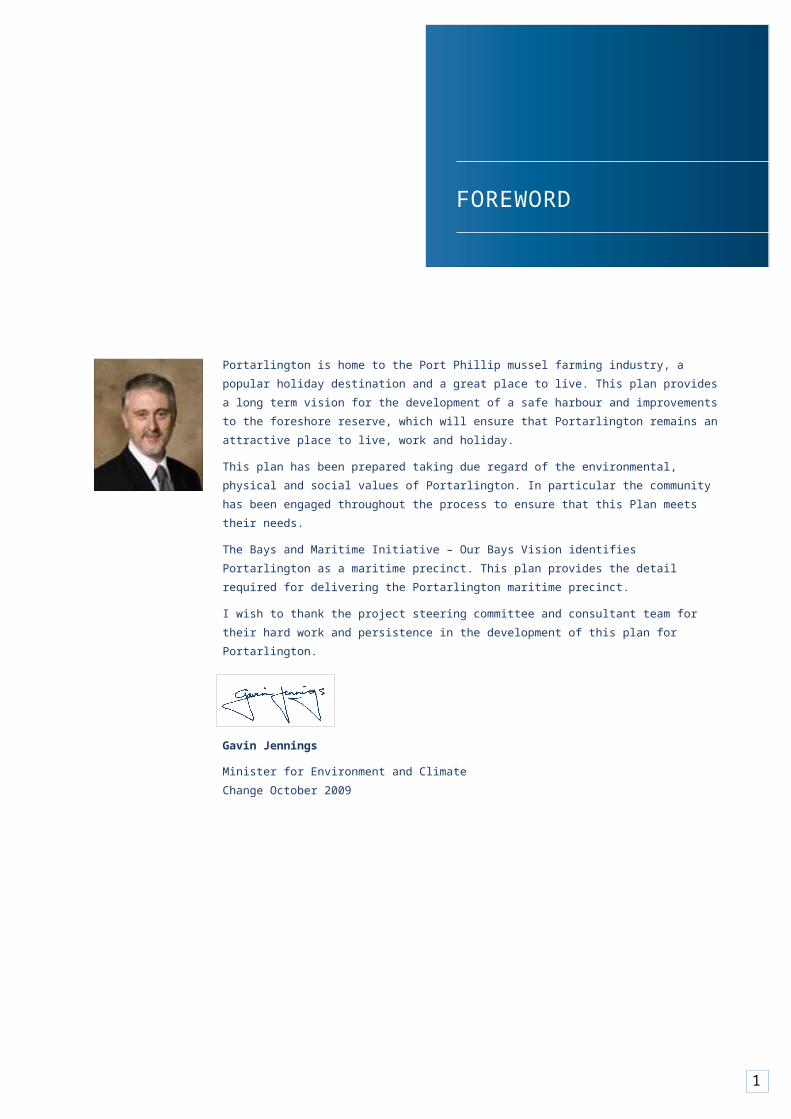
FOREWORD
Portarlington is home to the Port Phillip mussel farming industry, a popular holiday destination and a great place to live. This plan provides a long term vision for the development of a safe harbour and improvements to the foreshore reserve, which will ensure that Portarlington remains an attractive place to live, work and holiday.This plan has been prepared taking due regard of the environmental, physical and social values of Portarlington. In particular the community has been engaged throughout the process to ensure that this Plan meets their needs.The Bays and Maritime Initiative – Our Bays Vision identifies Portarlington as a maritime precinct. This plan provides the detail required for delivering the Portarlington maritime precinct.I wish to thank the project steering committee and consultant team for their hard work and persistence in the development of this plan for Portarlington.
Gavin Jennings
Minister for Environment and Climate Change October 2009

2
1 BACKGROUND
1.1 IntroductionIn October 2007, Parks Victoria, on behalf of a Steering Committee (comprising Parks Victoria, Department of Sustainability and Environment, Department of Innovation Industry and Regional Development, Department of Primary Industries, City of Greater Geelong, Marine Safety Victoria, Tourism Victoria, Central Coastal Board and Bellarine Bayside Foreshore Committee of Management) appointed a design and planning consortium led by Meinhardt Infrastructure and Environment Pty Ltd to undertake selected technical studies and prepare a Master Plan for the redevelopment of the Portarlington Safe Harbour.The project is focused on enhancing the existing marine infrastructure at Portarlington, which currently comprises the Pier, breakwater and berths.The project forms part of the State Government’s Bays and Maritime Initiative, which identifies a network of maritime precincts around Port Phillip and Western Port. This Initiative will see the revitalisation of maritime sites to create activity hubs with high quality public spaces, improved public access to recreational and tourism opportunities (on land and water), as well as provide additional jobs in tourism, aquaculture, construction and service industries.
This report presents the twenty year vision for the study area (as outlined in the Maritme Precinct Plan). Further detail on the first ten years of implementation is presented in the Detailed Master Plan.Climate Change and Sea Level Rise
Climate change is an important consideration for coastal areas and was highlighted as an area of concern by the community. Whilst it is difficult to predict the precise nature of impacts associated with climate change, any development in coastal areas should have regard to rising sea levels and anticipated extreme weather events.The Victorian Coastal Strategy 2008 recommends adopting a sea level rise of not less than 0.8 metres by the year 2100. The combined effects of tides, storm surges, coastal processes and local conditions, such as topography and geology, are also to be considered when assessing risks and impacts associated with climate change.In developing the Master Plan, consideration has been given to the anticipated impacts of climate change. This includes incorporation of a 0.8 metre sea level rise into the design.
Community and Stakeholder ConsultationThe community and stakeholders were extensively engaged throughout the preparation of the Master Plan through regular community bulletins, community workshops, focus group meetings, a community information day and one-on- one discussions. The information and feedback received from participants informed the establishment of the vision and principles for the study area and the development of the Master Plan.1
3
1 A report summarising the feedback received during exhibition of the Draft Master Plan, titled Portarlington Safe Harbour Master Plan – Overview of Stakeholder Feedback Regarding Draft Master Plan (November 2008) is available on the Parks Victoria website at www.parkweb.vic.gov.au.
4
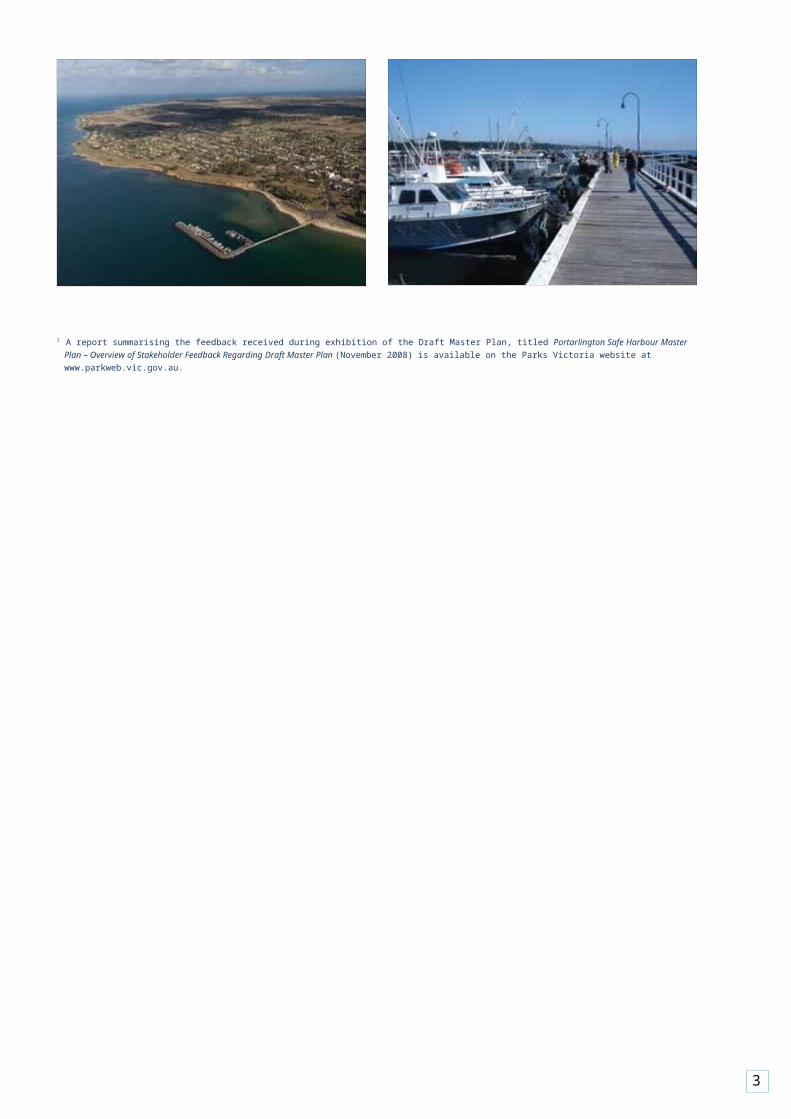
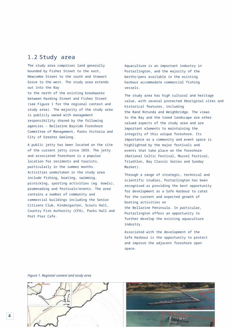
1.2Study areaThe study area comprises land generally bounded by Fisher Street to the east, Newcombe Street to the south and Stewart Grove to the west. The study area extends out into the Bayto the north of the existing breakwater between Harding Street and Fisher Street (see Figure 1 for the regional context and study area). The majority of the study area is publicly owned with management responsibility shared by the following agencies – Bellarine Bayside Foreshore Committee of Management, Parks Victoria and City of Greater Geelong.A public jetty has been located on the site of the current jetty since 1859. The jetty and associated foreshore is a popular location for residents and tourists, particularly in the summer months. Activities undertaken in the study area include fishing, boating, swimming, picnicking, sporting activities (eg. bowls), promenading and festivals/events. The area contains a number of community and commercial buildings including the Senior Citizens Club, Kindergarten, Scouts Hall, Country Fire Authority (CFA), Parks Hall and Port Pier Cafe.
Aquaculture is an important industry in Portarlington, and the majority of the berths/pens available in the existing harbour accommodate commercial fishing vessels.The study area has high cultural and heritage value, with several protected Aboriginal sites and historical features, includingthe Band Rotunda and Weighbridge. The views to the Bay and the treed landscape are other valued aspects of the study area and are important elements to maintaining the integrity of this unique foreshore. Its importance as a community and event space is highlighted by the major festivals and events that take place on the foreshore (National Celtic Festival, Mussel Festival, Triathlon, Bay Classic Series and Sunday Market).Through a range of strategic, technical and scientific studies, Portarlington has been recognised as providing the best opportunity for development as a Safe Harbour to cater for the current and expected growth of boating activities onthe Bellarine Peninsula. In particular, Portarlington offers an opportunity to further develop the existing aquaculture industry.Associated with the development of the Safe Harbour is the opportunity to protect and improve the adjacent foreshore open space.
Figure 1. Regional context and study area
5
1.3Vision and principlesVisionThe following Vision for the Portarlington Safe Harbour expresses the longer term aspirations for the Precinct (both landside and waterside):
The Portarlington Safe Harbour will be a high quality precinct incorporating commercial aquaculture and recreational fishing, boating, passive and active recreation and tourism activities for the local community and greater Bellarine Peninsula region.
Development of the Precinct will respect and build on the town’s village character, fishing and cultural heritage, as well as have regard to the natural environment, valued open spaces and views.
The precinct will develop in a staged and sustainable manner, contain commercially viable elements and showcase best practice outcomes in its design and operation.
PrinciplesThe following principles encapsulate the elements that arose from the consultation and research undertaken as part of this project. They have been categorised into themes based on social, environmental and financial objectives.
Social/Community
• Provide a focal/meeting point and high quality public spaces.
• Develop quality facilities and infrastructure for thecommunity and visitors.
• Provide pedestrian/bike paths for people of all abilities.
• Reduce the impact of vehicle movements and parking on the amenity of the reserve, while still providing convenient access to locals and visitors.
• Encourage shared use of facilities and parking areas.
• Improve linkages between the town centre and theforeshore/harbour.
• Provide for year round activity.• Provide enduring facilities and infrastructure for
shelter, safety, security and amenities for recreational and commercial (aquaculture, fishing and tourism) vessels and their users, and for other harbour-users.
• Provide for a possible future regional commuter/tourism
ferry service.
6
• Embrace the notion of a combined working port and a placeof community, tourism and leisure activity.
• Segregate commercial and recreation boating/fishing fromthe general public.
• Retain a beach within the harbour.
Environment
• Preserve, maintain and enhance the valued characteristics of the precinct (eg. beach, mature trees, open space, natural amphitheatre, fishing, boating).
• Minimise detrimental impacts on the physical environment by incorporating Water Sensitive Urban Design (WSUD) initiatives and adopting advanced Ecologically Sustainable Design (ESD) initiatives.
• Respond to climate change impacts, including latest sea levelrise predictions.
• Respect and protect sensitive natural and cultural sites.
• Encourage conservation and revegetation of the foreshoreand open spaces with indigenous plants.
• Maintain and enhance important view corridors between the town centre and the foreshore and the views over Port Phillip towards the Melbourne skyline and the You Yangs.
• Minimise impacts on key views through appropriate sitingand scale of buildings.
• Remove unnecessary buildings, roads, car parks and otherinfrastructure as the opportunity arises.
Economic
• Make a significant contribution to the town’s economy.• Expand the economic base of the town with
commerciallyviable tourism/retail development.
• Complement and enhance activity in Newcombe Street.
• Promote Portarlington as a focus for sustainable aquaculture and fine produce (Victoria’s home of mussel farming) as well as a premier recreation and commercial boating hub.
• Ensure development can be staged appropriately.

7
2 2.1Maritime Precinct PlanThe Maritime Precinct Plan articulates the longer term vision (up to 20 years) for the Precinct and contains the following key elements:
Landside• New town square providing a focal point for the
localcommunity and visitors.
• Retention of the Portarlington Bowls Club in themedium term.
• Retention of the kindergarten and CFA within existingfootprints.
• Relocation of the Scouts to another suitable location.
• Retention and upgrade of The Esplanade.• Potential connection to Stewart Grove between
WestForeshore Road and Newcombe Street.
• Beachfront boardwalk and commercial development incorporating up to three buildings (with a maximum of two storeys each). New commercial development is to complement existing businesses in Newcombe Street.
• Improved pedestrian connections between the foreshoreand town centre.
• Enhanced aesthetics, amenity, use and safety of open spaceareas (eg. shaded recreation and picnic areas).
Figure 2. Maritime Precinct Plan
MARITIME PRECINCT PLAN
• Incorporation of water conservation and stormwatertreatment measures.
• Mix of formal and informal landscape settings.• Rationalised vehicular circulation and parking, with
improvedpedestrian and vehicle safety.
Harbour• New wider Pier that allows for separation of pedestrians
and vehicles.• Improved protection for boats.• New facilities for boating related activities including:
– Up to 45 commercial berths.– Up to 100 recreational berths.– Service berth comprising re-fuelling and pump out.– Provision for a possible future regional
commuter/tourism ferry service.• Realigned stormwater outfalls providing improved visual
and environmental amenity.• Additional pedestrian recreational access and use
(promenading, fishing) on the new breakwaters.Appendix A contains the Maritime Precinct Plan (extract shown below).
8

9
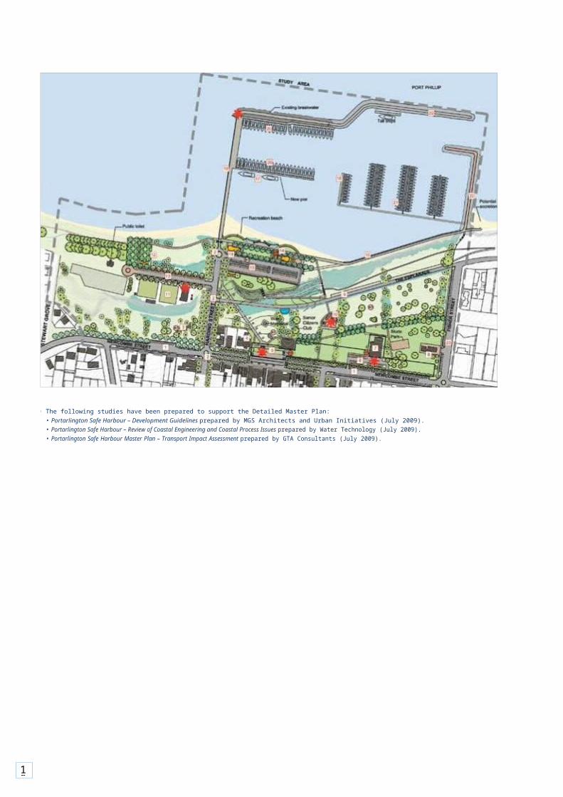
2.2Detailed Master PlanThe Detailed Master Plan focuses on the delivery of the first ten years of the project and is supported by a number of technical studies on: coastal engineering and processes; built form and landscape design; and traffic and parking.2
2.2.1 Development guidelinesThe Development Guidelines focus on built form and landscape design. The general development principles outlined havebeen prepared having regard to ESD initiatives, such as waste minimisation and storm water harvesting.The Guidelines acknowledge the minimum sea level rise of 0.8 metres by year 2100 adopted by the Victorian Coastal Strategy and it is recommended that the building ground level of development on the foreshore be elevated to a minimumof 2.0 metres above sea level.
Whilst the Guidelines provide direction on land use, built form and landscape expectations, they are not intended to be prescriptive. Proposals that provide an alternative response orsolution, which is underpinned by the principles outlined in the document, should be considered.Figure 3 provides an extract from the Detailed Master Plan and highlights the 23 key elements. A brief description of each of these elements is provided in Section 2.2.2.The complete version of the Detailed Master Plan is included in Appendix B.
Figure 3. Detailed Master Plan
10
2 The following studies have been prepared to support the Detailed Master Plan:• Portarlington Safe Harbour – Development Guidelines prepared by MGS Architects and Urban Initiatives (July 2009).• Portarlington Safe Harbour – Review of Coastal Engineering and Coastal Process Issues prepared by Water Technology (July 2009).• Portarlington Safe Harbour Master Plan – Transport Impact Assessment prepared by GTA Consultants (July 2009).

11
2.2.2 Landside elementsNewcombe Street (Element 1)Additional angle parking spaces (up to 20 spaces) are to be provided west of Harding Street along the park edge. Parking capacity east of Town Square is to be maximised with angle parking.
Harding Street (Element 2)The proposal aims to provide clear access to and within the Safe Harbour Precinct, maximise parking and formalise footpaths.Harding Street is to be formalised with 2.5 metre footpaths against the property line, a tree lined nature strip of similar width and 90 degree parking on both sides. Healthy Elm trees will be retained and supplemented with a formal planting of suitable trees to frame this important vista.
Scouts hall (Element 3)Remove the hall and nearby toilet block, subject to successful relocation of the Scouts and a heritage assessment of the building.
Kindergarten (Element 4)The Kindergarten is to remain within the existing footprint.
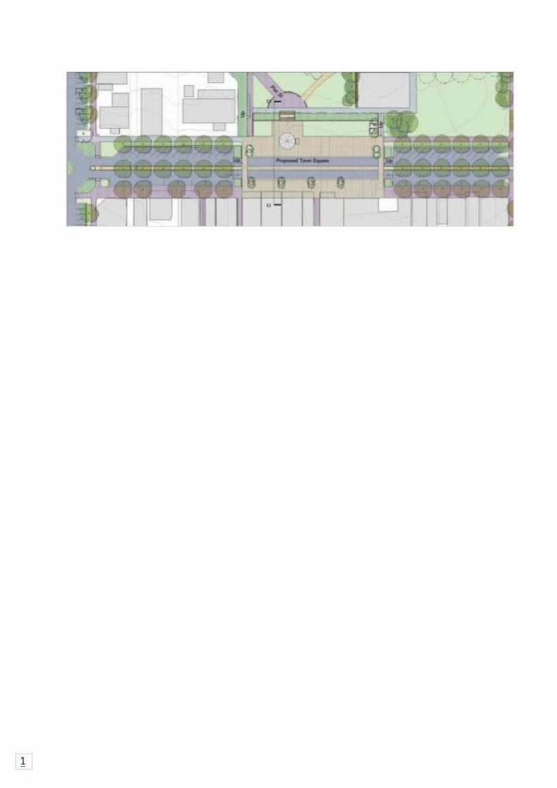
Town square/Pier Street (Element 5)A Town Square is to be developed at the intersection of Newcombe Street and Pier Street. Traffic along Newcombe Street will still be accommodated and the space will be levelled to provide a more formal setting for the Grand Hotel and Rotunda and Weighbridge that will be re-sited and restored as a focal point in the square. The square is to be a simple flexible space that caters for events as well as being a new heart for Portarlington.Pier Street is to be closed to vehicular traffic. Small incidental play events and sculpture will be set within lawns adjacent to the north eastern edge of this promenade. Tree planting is limited to maintain open view of the harbour from the town square.
Figure 4. Newcombe Street town square
12
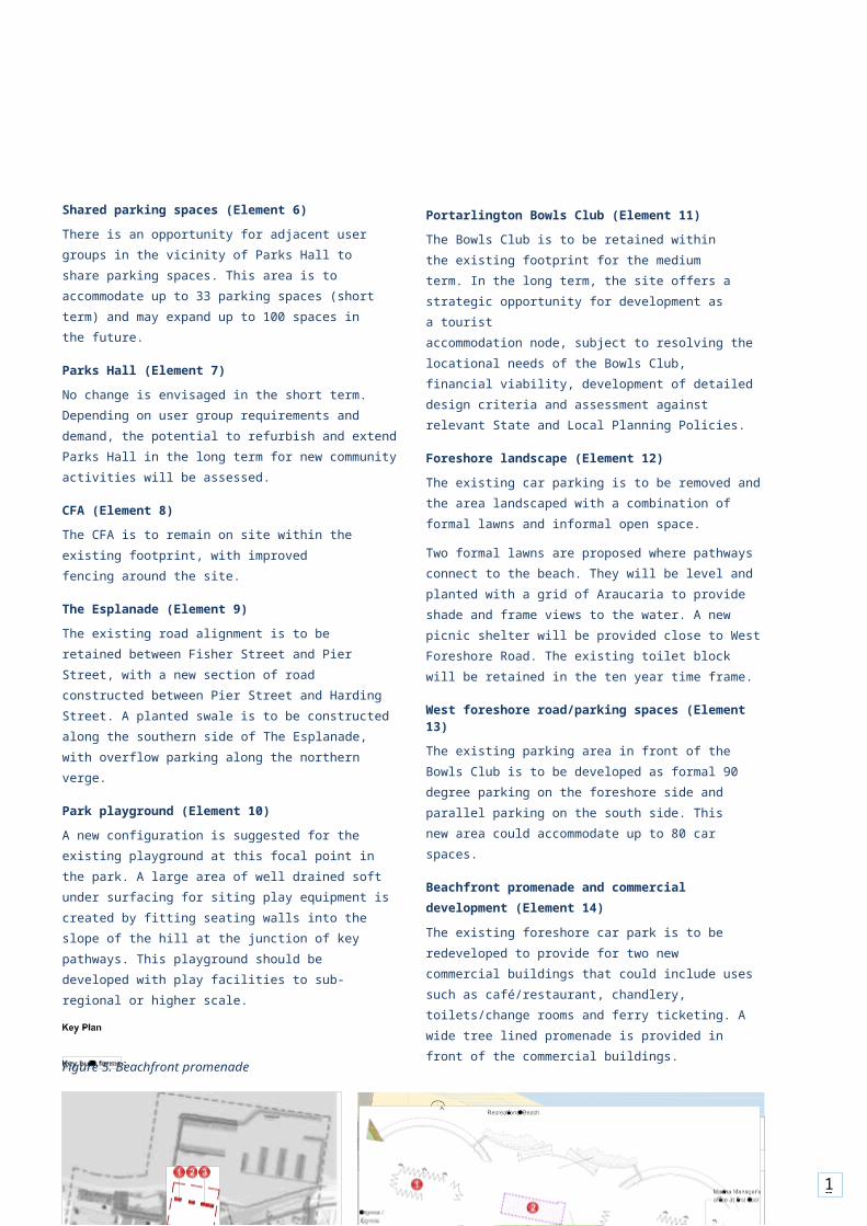
Shared parking spaces (Element 6)There is an opportunity for adjacent user groups in the vicinity of Parks Hall to share parking spaces. This area is to accommodate up to 33 parking spaces (short term) and may expand up to 100 spaces in the future.
Parks Hall (Element 7)No change is envisaged in the short term. Depending on user group requirements and demand, the potential to refurbish and extend Parks Hall in the long term for new community activities will be assessed.
CFA (Element 8)The CFA is to remain on site within the existing footprint, with improved fencing around the site.
The Esplanade (Element 9)The existing road alignment is to be retained between Fisher Street and Pier Street, with a new section of road constructed between Pier Street and Harding Street. A planted swale is to be constructed along the southern side of The Esplanade, with overflow parking along the northern verge.
Park playground (Element 10)A new configuration is suggested for the existing playground at this focal point in the park. A large area of well drained soft under surfacing for siting play equipment is created by fitting seating walls into the slope of the hill at the junction of key pathways. This playground should be developed with play facilities to sub-regional or higher scale.
Figure 5. Beachfront promenade
Portarlington Bowls Club (Element 11)The Bowls Club is to be retained within the existing footprint for the medium term. In the long term, the site offers a strategic opportunity for development as a touristaccommodation node, subject to resolving the locational needs of the Bowls Club, financial viability, development of detailed design criteria and assessment against relevant State and Local Planning Policies.
Foreshore landscape (Element 12)The existing car parking is to be removed and the area landscaped with a combination of formal lawns and informal open space.Two formal lawns are proposed where pathways connect to the beach. They will be level and planted with a grid of Araucaria to provide shade and frame views to the water. A new picnic shelter will be provided close to West Foreshore Road. The existing toilet block will be retained in the ten year time frame.
West foreshore road/parking spaces (Element 13)The existing parking area in front of the Bowls Club is to be developed as formal 90 degree parking on the foreshore side and parallel parking on the south side. This new area could accommodate up to 80 car spaces.
Beachfront promenade and commercial development (Element 14)The existing foreshore car park is to be redeveloped to provide for two new commercial buildings that could include uses such as café/restaurant, chandlery, toilets/change rooms and ferry ticketing. A wide tree lined promenade is provided in front of the commercial buildings.
13
14
Figure 6. Building A elevation
Figure 7. Building C elevation
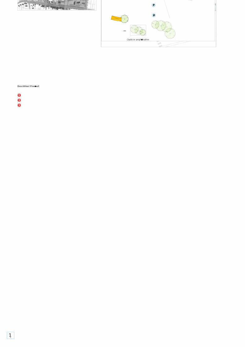
East foreshore parking spaces and landscape (Element 15)Remove existing public toilets and Port Pier Café and provide parking (approximately 150 spaces) with landscaped edges to the south of the beachfront development. A grassed or stepped amphitheatre is to be established south of the car park.
Fisher Street (Element 23)A shared pathway and 90 degree parking is envisaged along the eastern park edge.

15
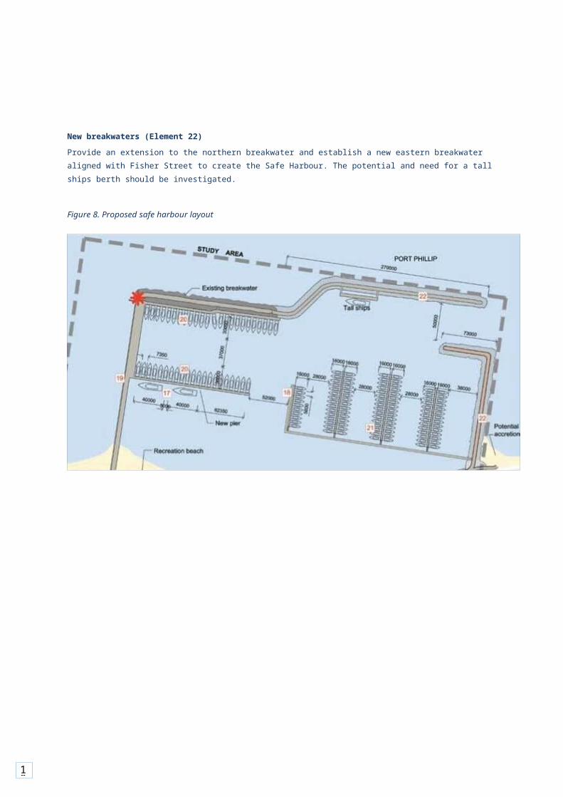
2.2.3 Harbour elementsTo provide a Safe Harbour, it is proposed to establish a new eastern breakwater aligned with Fisher Street and extend the existing northern breakwater to overlap with the eastern breakwater at the entrance. Both breakwaters would allow pedestrian access.The design of the Safe Harbour has been informed by an assessment of coastal engineering and process issues3,in particular assessment of key structural dimensions of breakwaters; analysis of wave protection afforded by the harbour design; the options available to mitigate impacts on coastal processes; and assessment of the dredging requirements.The ultimate configuration of key elements within the Safe Harbour, as well as the design of the breakwaters, will require further investigations to optimise the layout and construction methods.The key harbour elements are outlined below.
Recreational berthing maintenance access road (Element 16)The new maintenance access road would connect the beachfront commercial area with the eastern breakwater and recreational marina. Access to the road will be via an informal/ grassed path from the east foreshore car park. Whilst theroad will be shared by pedestrians and authorised vehicles, it is anticipated that vehicle usage will be restricted to thoseundertaking sand removal works and occasional maintenance associated with the eastern breakwater.
Ferry Berthing (Element 17)Opportunity to provide two ferry berths with safe separation from commercial activities and within walking distance to beachfront commercial development. Subject to viability and providing safe separation between the ferry and beach users.
Refuelling/sewage pump out (Element 18)The service berth, comprising refuelling and sewage pump out facilities, is proposed to be located at the western end of the recreational berths and would be a shared facility for both commercial and recreational vessels.
Portarlington Pier (Element 19)The existing concrete Pier is to be demolished and replaced with a wider pier that allows for separation of pedestrian and vehicle movements. Wave protection will be incorporated along the western edge of the Pier, to prevent sand and waves from entering the harbour. A covered walkway is to be provided in the long term for pedestrians, from the beachfront area to the ferry berths.
Commercial berths (Element 20)Provide for up to 45 commercial berths off the Portarlington Pier to service the aquaculture industry. The layout of berths has been designed to meet the appropriate Australian Standards.The east-west aligned pier located along the northern breakwater is expected to remain for the foreseeable future for berthing of commercial vessels. The smaller east-westaligned pier located to the south will be replaced once demand necessitates expansion of the commercial berths.
Recreational berthing and boating facilities (Element 21)An area for recreational berthing and boating facilities, with capacity for approximately 100 berths, is proposed to be located off the eastern breakwater and would comprise a series of floating finger pontoons. Further investigations are required to confirm the suitability of the access arrangements off the eastern breakwater.

16
3 Report titled Review of Coastal Engineering and Coastal Process Issues prepared by Water Technology (July 2009).

17
New breakwaters (Element 22)Provide an extension to the northern breakwater and establish a new eastern breakwater aligned with Fisher Street to create the Safe Harbour. The potential and need for a tall ships berth should be investigated.
Figure 8. Proposed safe harbour layout
18
2.2.4 Other general elementsCar ParkingA transport impact assessment was undertaken by GTA Consultants. It determined that the proposed supply of 645 formal parking spaces within the study area (including parking on both sides of Newcombe Street) is expected to be adequate to accommodate the regular peak demands in each area within the site.With regard to car parking areas, the following summarises the location and number of car spaces within the study area:• Newcombe Street (west of Harding Street) – up to
20 spaces.• West Foreshore Road (in front of Bowls Club) – up
to80 spaces.
• East foreshore (behind the promenade and commercialbuildings) – approximately 160 spaces.
• Harding Street (north of Newcombe Street) – approximately90 spaces.
• Parks Hall – approximately 30 spaces. This car park has the ability to expand to accommodate up to 100 spaces in the longer term.
• Fisher Street – approximately 70 spaces.The remaining spaces are located on Newcombe
Street. Provision has been made for informal
overflow parking on thenorth side of The Esplanade and to the west of the Bowls Club.
PathwaysThe Detailed Master Plan proposes upgrading existing paths and construction of new paths, including:• Conversion of Pier Street to a shared
pedestrian/bicycle path.• A wide promenade along the foreshore (east of the
Pier)with paths leading east and west from this point.• Paths linking the upgraded playground to the
beachfrontpromenade and Newcombe Street.
• A path linking Fisher Street to the eastern breakwater.
• A path along both sides of Harding Street, north ofNewcombe Street.
• A path along the north side of Newcombe Street.
LandscapingThe landscape guidelines are based on a number of elements including:• Removal of vehicle access on the foreshore, except
ondesignated roadways and car parks.
• Commencing a re-planting strategy as soon as possible to enable trees to establish while existing mature trees decline. Unsafe or unhealthy trees should be removed when their retention is no longer cost effective.
• Development of site drainage and stormwater harvesting
and treatment systems to assist with park watering.• Planting of a combination of native and indigenous
trees.• Attending to unstable embankments with
earthworks,planting and grassing.

19
4 The Portarlington Safe Harbour Master Plan – Transport Impact Assessment report includes an assessment of traffic management, transport and parking issues associated with the Detailed Master Plan.

20
3 3.1Cost planA cost plan has been prepared by Donald Cant Watts Corke (DCWC) based on the Detailed Master Plan and other plans prepared by MGS Architects and Urban Initiatives.The estimated costs of construction for the landside elements is approximately $22 million and the safe harbour elements is about $36 million. The total project cost (including fees and allowances) is approximately $58 million.This investment is capable of being staged over 10 years, through private, public and community initiatives and investment.
3.2Planning controls and land managementWith regard to the local Planning controls contained in the Greater Geelong Planning Scheme, it is noted that some of the proposed key elements contained within the Detailed Master Plan require a planning permit (eg. the Beachfront Commercial Development). However, there are no provisions in the Planning Scheme that prohibit the implementation of the key elements and therefore, no planning scheme amendment is required to implement the Detailed Master Plan.Notwithstanding, it may be necessary to provide some confidence to Parks Victoria, the City of Greater Geelong and Bellarine Bayside Foreshore Committee of Management that the key elements identified in the Detailed Master Plan will be implemented in the form generally depicted in the Plan. Arange of planning tools exist in the Victorian Planning Provisions to “give effect or statutory weight” to the Detailed Master Plan and these could be explored by the public land managers.
IMPLEMENTATION
With regard to land management responsibilities, consideration was given to appointing one land manager to be responsible for all of the study area. However, given the fact that the current model appears to be working well, together with the combination of land and water elements within the study area, it is recommended that the existing land managers retain their current roles within the Safe Harbour Precinct.
3.3Next stepsPublic sector agencies will establish an appropriate model to enable the delivery of the Portarlington Safe Harbour. The assessment of potential models will include a number of combinations for public/private sector investment of various elements.Through the consultation undertaken during the study, a clear message from the aquaculture industry has been its desire to remain under government management. The potential models for delivery will consider this scenario.Once the delivery model has been confirmed, funding will be sought for the construction of key elements of the Plan. Further detailed design will need to be undertaken for each of the key elements prior to construction.It is important to note that the development of the Precinct is intended to be undertaken in stages and will be driven by market demand.

21