130 th & 145 STATION AREA PLANNING Plan for Public Review
35
Station Area Planning 130 th & 145 th STATION AREA PLANNING Plan for Public Review March 2021 DRAFT 3/17/2021
Transcript of 130 th & 145 STATION AREA PLANNING Plan for Public Review

Station Area Planning
130th & 145th STATION AREA PLANNING
Plan for Public Review
March 2021
DRAFT 3/17/2021

DR
AFT
2
THIS PAGE LEFT INTENTIONALLY BLANK
DR
AFT
3
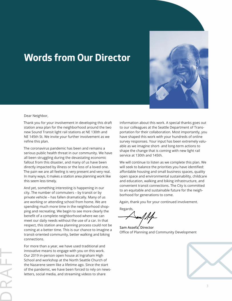
Dear Neighbor,
Thank you for your involvement in developing this draft station area plan for the neighborhood around the two new Sound Transit light rail stations at NE 130th and NE 145th St. We invite your further involvement as we refine this plan.
The coronavirus pandemic has been and remains a serious public health threat in our community. We have all been struggling during the devastating economic fallout from this disaster, and many of us have been directly impacted by illness or the loss of a loved one. The pain we are all feeling is very present and very real. In many ways, it makes a station area planning work like this seem less timely.
And yet, something interesting is happening in our city. The number of commuters – by transit or by private vehicle – has fallen dramatically. Many of us are working or attending school from home. We are spending much more time in the neighborhood shop-ping and recreating. We begin to see more clearly the benefit of a complete neighborhood where we can meet our daily needs without the use of a car. In that respect, this station area planning process could not be coming at a better time. This is our chance to imagine a transit-oriented community, better walking and biking connections.
For more than a year, we have used traditional and innovative means to engage with you on this work. Our 2019 in-person open house at Ingraham High School and workshop at the North Seattle Church of the Nazarene seem like a lifetime ago. Since the start of the pandemic, we have been forced to rely on news-letters, social media, and streaming videos to share
information about this work. A special thanks goes out to our colleagues at the Seattle Department of Trans-portation for their collaboration. Most importantly, you have shaped this work with your hundreds of online survey responses. Your input has been extremely valu-able as we imagine short- and long-term actions to shape the change that is coming with new light rail service at 130th and 145th.
We will continue to listen as we complete this plan. We will seek to balance the priorities you have identified: affordable housing and small business spaces, quality open space and environmental sustainability, childcare and education, walking and biking infrastructure, and convenient transit connections. The City is committed to an equitable and sustainable future for the neigh-borhood for generations to come.
Again, thank you for your continued involvement.
Regards,
Sam Assefa, Director Office of Planning and Community Development
Words from Our Director
DR
AFT
4
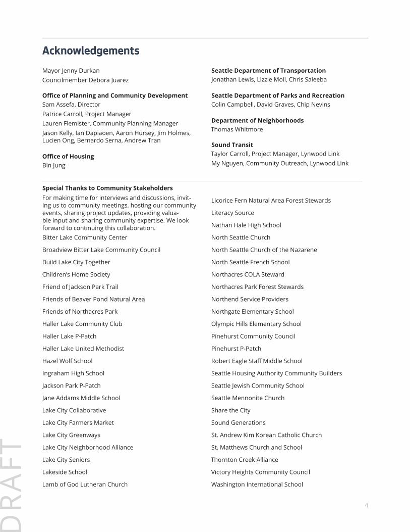
AcknowledgementsMayor Jenny DurkanCouncilmember Debora Juarez
Office of Planning and Community DevelopmentSam Assefa, DirectorPatrice Carroll, Project ManagerLauren Flemister, Community Planning ManagerJason Kelly, Ian Dapiaoen, Aaron Hursey, Jim Holmes, Lucien Ong, Bernardo Serna, Andrew Tran
Office of HousingBin Jung
Seattle Department of TransportationJonathan Lewis, Lizzie Moll, Chris Saleeba
Seattle Department of Parks and RecreationColin Campbell, David Graves, Chip Nevins
Department of NeighborhoodsThomas Whitmore
Sound TransitTaylor Carroll, Project Manager, Lynwood LinkMy Nguyen, Community Outreach, Lynwood Link
Special Thanks to Community Stakeholders For making time for interviews and discussions, invit-ing us to community meetings, hosting our community events, sharing project updates, providing valua-ble input and sharing community expertise. We look forward to continuing this collaboration.Bitter Lake Community Center
Broadview Bitter Lake Community Council
Build Lake City Together
Children’s Home Society
Friend of Jackson Park Trail
Friends of Beaver Pond Natural Area
Friends of Northacres Park
Haller Lake Community Club
Haller Lake P-Patch
Haller Lake United Methodist
Hazel Wolf School
Ingraham High School
Jackson Park P-Patch
Jane Addams Middle School
Lake City Collaborative
Lake City Farmers Market
Lake City Greenways
Lake City Neighborhood Alliance
Lake City Seniors
Lakeside School
Lamb of God Lutheran Church
Licorice Fern Natural Area Forest Stewards
Literacy Source
Nathan Hale High School
North Seattle Church
North Seattle Church of the Nazarene
North Seattle French School
Northacres COLA Steward
Northacres Park Forest Stewards
Northend Service Providers
Northgate Elementary School
Olympic Hills Elementary School
Pinehurst Community Council
Pinehurst P-Patch
Robert Eagle Staff Middle School
Seattle Housing Authority Community Builders
Seattle Jewish Community School
Seattle Mennonite Church
Share the City
Sound Generations
St. Andrew Kim Korean Catholic Church
St. Matthews Church and School
Thornton Creek Alliance
Victory Heights Community Council
Washington International School
DR
AFT
5
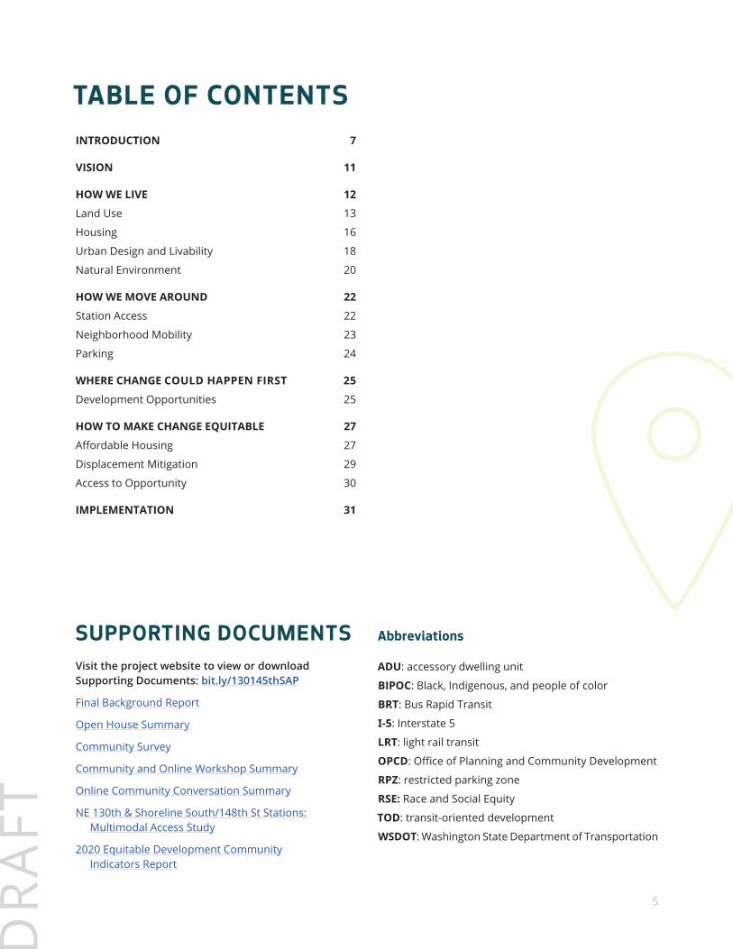
TABLE OF CONTENTS
Abbreviations
ADU: accessory dwelling unit
BIPOC: Black, Indigenous, and people of color
BRT: Bus Rapid Transit
I-5: Interstate 5
LRT: light rail transit
OPCD: Office of Planning and Community Development
RPZ: restricted parking zone
RSE: Race and Social Equity
TOD: transit-oriented development
WSDOT: Washington State Department of Transportation
INTRODUCTION 7
VISION 11
HOW WE LIVE 12
Land Use 13
Housing 16
Urban Design and Livability 18
Natural Environment 20
HOW WE MOVE AROUND 22
Station Access 22
Neighborhood Mobility 23
Parking 24
WHERE CHANGE COULD HAPPEN FIRST 25
Development Opportunities 25
HOW TO MAKE CHANGE EQUITABLE 27
Affordable Housing 27
Displacement Mitigation 29
Access to Opportunity 30
IMPLEMENTATION 31
SUPPORTING DOCUMENTSVisit the project website to view or download Supporting Documents: bit.ly/130145thSAP
Final Background Report
Open House Summary
Community Survey
Community and Online Workshop Summary
Online Community Conversation Summary
NE 130th & Shoreline South/148th St Stations: Multimodal Access Study
2020 Equitable Development Community Indicators Report
home | 6
DR
AFT
Let Us Know What You Think!
The Draft Plan is now available for your review and comments: bit.ly/130145thSAP. Comments will be accepted until April 16, 2021. There are multiple ways for you to review the Draft Plan and provide your feedback.
1. Visit the Draft Plan online open house
2. Read the FAQs and submit new questions to [email protected]
3. Email a letter or comments to [email protected]
4. Invite us to your community meeting. Email [email protected] to schedule
Next Steps• We will review all your comments received by April 16th.
• We will make changes and issue a Final Plan in 2021.
• We may implement a land use change for the one block nearest the station in 2021.
• We will commit to a timeline for station area zoning and environmental studies by the end of 2021
Stay InformedIf you would like to receive project updates, please sign up here: bit.ly/130145thSAP
home | 7
DR
AFT
INTRODUCTION
To ensure the benefits of new high capacity transit are equitably distributed, and additional investments are equitably leveraged to lift up those most in need, communities along transit corridors are creating plans so more people can live, work or shop near new stations. Shoreline, Mountlake Terrace and Lynnwood have completed station area plans, adopted new land use regulations and funded infrastructure to transform areas around stations to vibrant, mixed-use centers. Sound Transit has strengthened its commitment to increase affordable housing as part of transit-oriented development on surplus property.
The 130th and 145th Station Area Plan will outline the community and City’s concept(s) for land use, mobil-ity and other policies and investments to support this regional vision for integrating fast and reliable transit with compact walkable communities for generations to come. Regional transit investments create a unique opportunity for the City of Seattle, surrounding commu-nities, and agency partners to work together to realize this shared vision.
The purpose of the 130th and 145th Station Area Plan is to guide decisions for public and private investment near these high capacity transit stations. The Seattle Comprehensive Plan and other citywide plans and poli-cies act as a starting point for the goals, strategies and early actions contained in this plan. Local conditions and community input, shape and refine citywide guid-ance to fit the unique challenges and opportunities of this station area. Topics addressed in this plan include land use, mobility, housing, open space and other community needs.
Regional investments are bringing new high capacity transit to North Seattle. Sound Transit’s Lynwood Link Extension will extend service north of Northgate to Lynwood including light rail stations at NE 130th Street and NE 148th Street (recently renamed the Shoreline South/148th Station). Stride bus rapid transit service, connecting the Shoreline South/148th Station to Bothell, will include several stations in Seattle along NE 145th Street. The capital cost of new transit is shared by Central Puget Sound Region taxpayers and the Federal Transit Administration.
home | 8
DR
AFT
T
1/2 mile from LRT stations
1/4 mile from BRT station
T
TNE 130TH ST
NE 130TH STNE 130TH ST
5TH
AVE
NE
15TH
AVE
NE15
TH AV
E NE
NE 115TH ST
AUR
OR
A AV
E N
N 145TH ST
LAKE
CIT
Y W
AY N
E
N 115TH ST
NE NORTHGATE WAY
LIN
DEN
AVE
NIN
TER
UR
BAN
TR
AIL
ROOSEVELT WAY N
PINE
HURS
T W
AY N
E
RO
OSE
VELT
WAY
NE
N 110TH ST
RO
OSE
VELT
WAY
NE
NE 145TH STCITY LIMITS
NE 125TH STNE 125TH ST NE 125TH ST
CITY LIMITS
DEN
SMO
RE
AVE
N
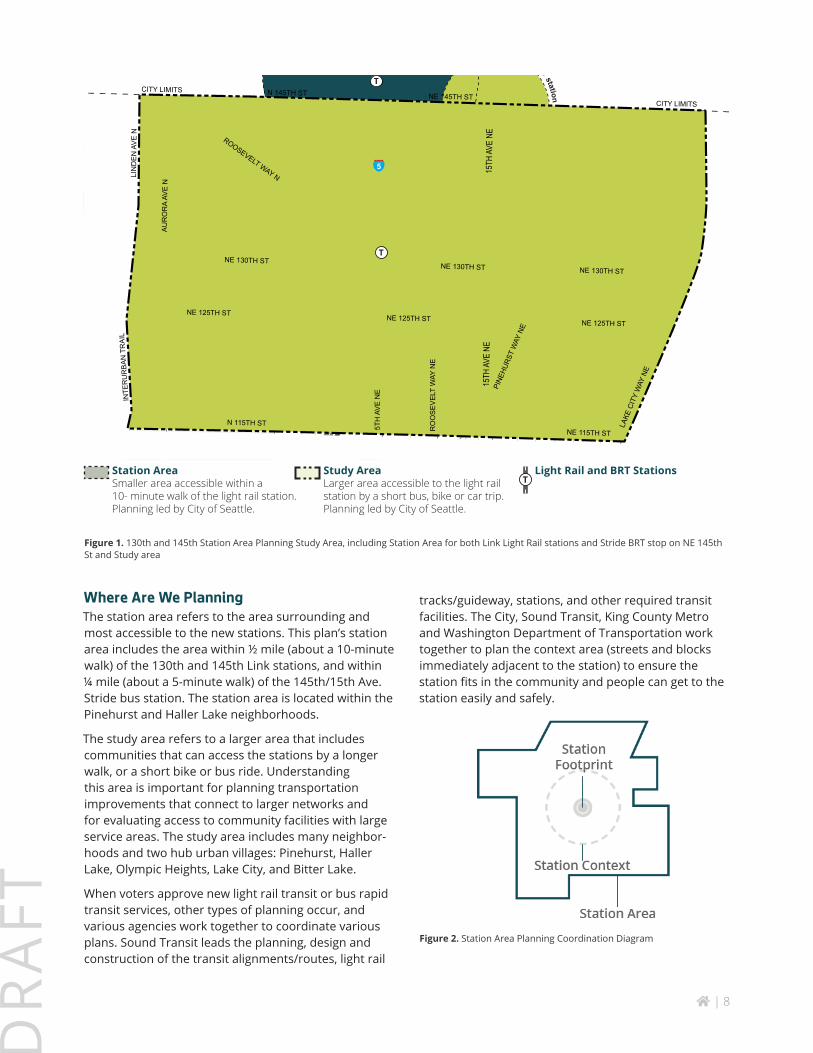
Figure 1. 130th and 145th Station Area Planning Study Area, including Station Area for both Link Light Rail stations and Stride BRT stop on NE 145th St and Study area
tracks/guideway, stations, and other required transit facilities. The City, Sound Transit, King County Metro and Washington Department of Transportation work together to plan the context area (streets and blocks immediately adjacent to the station) to ensure the station fits in the community and people can get to the station easily and safely.
Figure 2. Station Area Planning Coordination Diagram
Where Are We PlanningThe station area refers to the area surrounding and most accessible to the new stations. This plan’s station area includes the area within ½ mile (about a 10-minute walk) of the 130th and 145th Link stations, and within ¼ mile (about a 5-minute walk) of the 145th/15th Ave. Stride bus station. The station area is located within the Pinehurst and Haller Lake neighborhoods.
The study area refers to a larger area that includes communities that can access the stations by a longer walk, or a short bike or bus ride. Understanding this area is important for planning transportation improvements that connect to larger networks and for evaluating access to community facilities with large service areas. The study area includes many neighbor-hoods and two hub urban villages: Pinehurst, Haller Lake, Olympic Heights, Lake City, and Bitter Lake.
When voters approve new light rail transit or bus rapid transit services, other types of planning occur, and various agencies work together to coordinate various plans. Sound Transit leads the planning, design and construction of the transit alignments/routes, light rail
Station AreaSmaller area accessible within a 10- minute walk of the light rail station. Planning led by City of Seattle.
Study AreaLarger area accessible to the light rail station by a short bus, bike or car trip. Planning led by City of Seattle.
Light Rail and BRT StationsT
home | 9
DR
AFT
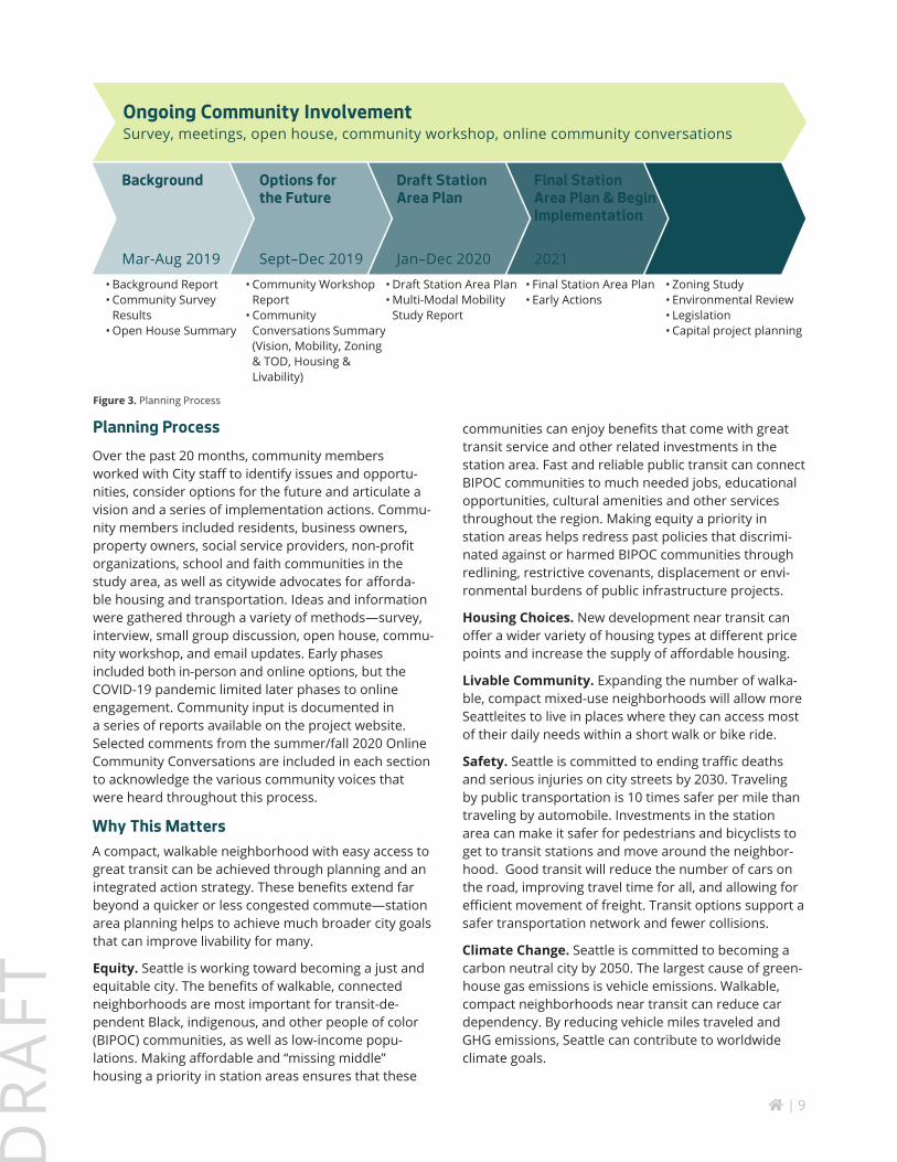
Planning ProcessOver the past 20 months, community members worked with City staff to identify issues and opportu-nities, consider options for the future and articulate a vision and a series of implementation actions. Commu-nity members included residents, business owners, property owners, social service providers, non-profit organizations, school and faith communities in the study area, as well as citywide advocates for afforda-ble housing and transportation. Ideas and information were gathered through a variety of methods—survey, interview, small group discussion, open house, commu-nity workshop, and email updates. Early phases included both in-person and online options, but the COVID-19 pandemic limited later phases to online engagement. Community input is documented in a series of reports available on the project website. Selected comments from the summer/fall 2020 Online Community Conversations are included in each section to acknowledge the various community voices that were heard throughout this process.
Why This MattersA compact, walkable neighborhood with easy access to great transit can be achieved through planning and an integrated action strategy. These benefits extend far beyond a quicker or less congested commute—station area planning helps to achieve much broader city goals that can improve livability for many.
Equity. Seattle is working toward becoming a just and equitable city. The benefits of walkable, connected neighborhoods are most important for transit-de-pendent Black, indigenous, and other people of color (BIPOC) communities, as well as low-income popu-lations. Making affordable and “missing middle” housing a priority in station areas ensures that these
communities can enjoy benefits that come with great transit service and other related investments in the station area. Fast and reliable public transit can connect BIPOC communities to much needed jobs, educational opportunities, cultural amenities and other services throughout the region. Making equity a priority in station areas helps redress past policies that discrimi-nated against or harmed BIPOC communities through redlining, restrictive covenants, displacement or envi-ronmental burdens of public infrastructure projects.
Housing Choices. New development near transit can offer a wider variety of housing types at different price points and increase the supply of affordable housing.
Livable Community. Expanding the number of walka-ble, compact mixed-use neighborhoods will allow more Seattleites to live in places where they can access most of their daily needs within a short walk or bike ride.
Safety. Seattle is committed to ending traffic deaths and serious injuries on city streets by 2030. Traveling by public transportation is 10 times safer per mile than traveling by automobile. Investments in the station area can make it safer for pedestrians and bicyclists to get to transit stations and move around the neighbor-hood. Good transit will reduce the number of cars on the road, improving travel time for all, and allowing for efficient movement of freight. Transit options support a safer transportation network and fewer collisions.
Climate Change. Seattle is committed to becoming a carbon neutral city by 2050. The largest cause of green-house gas emissions is vehicle emissions. Walkable, compact neighborhoods near transit can reduce car dependency. By reducing vehicle miles traveled and GHG emissions, Seattle can contribute to worldwide climate goals.
Figure 3. Planning Process
Ongoing Community InvolvementSurvey, meetings, open house, community workshop, online community conversations
Background Options for the Future
Draft Station Area Plan
Final Station Area Plan & Begin Implementation
Continue Implementation
Mar-Aug 2019 Sept–Dec 2019 Jan–Dec 2020 2021 2022+
• Background Report• Community Survey
Results• Open House Summary
• Community Workshop Report
• Community Conversations Summary (Vision, Mobility, Zoning & TOD, Housing & Livability)
• Draft Station Area Plan• Multi-Modal Mobility
Study Report
• Final Station Area Plan• Early Actions
• Zoning Study• Environmental Review• Legislation• Capital project planning
home | 10
DR
AFT
Environment. New energy-efficient, compact devel-opment in station areas will consume fewer resources, and improve water quality through better stormwa-ter management standards. Encouraging development to locate near transit helps protect farmland and open space in the region that are essential for a sustainable food system and a healthy watershed.
Sustainable Transit. To be successful, transit agen-cies must achieve a level of ridership and revenue to support the service provided. Higher density devel-opment within walking distance of stations promotes more ridership and more efficient transit operations.
Health. More walking and biking can improve overall health. Less driving can improve local air quality by lowering particulates and emissions.
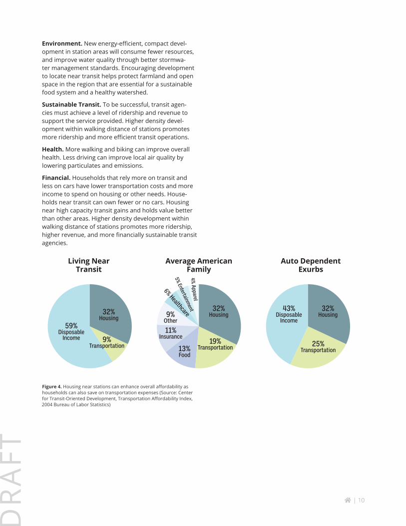
Financial. Households that rely more on transit and less on cars have lower transportation costs and more income to spend on housing or other needs. House-holds near transit can own fewer or no cars. Housing near high capacity transit gains and holds value better than other areas. Higher density development within walking distance of stations promotes more ridership, higher revenue, and more financially sustainable transit agencies.
59%Disposable
Income
32%Housing
32%Housing
32%Housing
43%Disposable
Income
9%Transportation 25%
Transportation19%
Transportation13%Food
11%Insurance
9%Other
6% Healthcare
5% Entertainment
4% Apparel
Living Near Transit
Average American Family
Auto Dependent Exurbs
Figure 4. Housing near stations can enhance overall affordability as households can also save on transportation expenses (Source: Center for Transit-Oriented Development, Transportation Affordability Index, 2004 Bureau of Labor Statistics)

home | 11
DR
AFT
VISIONOver the past two years the community shared aspirations for the station area through surveys, interviews, in-person and online engagement events. City staff blended this input into a concise vision statement that was shared with the community in the Online Community Conversation about Vision (Summer/Fall 2020). Response to the vision statement was very positive. The goals, strategies and early actions included in this Draft Plan are guided by this vision:
Figure 5. The future station area will have more homes, walkable streets, great transit and local businesses.
What We Heard about the VISION“I love it!”
“I would like to see mention of sustainability, housing density, green stormwater infrastructure included.”
“I’d mention good connections to surrounding neighborhoods.”
“Would like to see the vision acknowledge and build on existing assets and history, not just imagine a new/different place from what is already here.”
“Will need to add more sidewalks if the “vibrant and walkable” statement is going to be true.”
“I like that it’s positive, but I’m still concerned we could wind up with Northgate II.”
“Adding something about the importance of quiet would be good.”
“Walkability like a 15 minute neighborhood where people can safely walk/bike to child care/school/the station/drug store/grocery store/coffee shops/etc.”
The 130th and 145th Station Area is a lively, walkable and welcoming North Seattle neighborhood. Major streets have roomy, tree-lined sidewalks, and other green infrastructure. Bicycle infrastructure makes everyday trips to transit stations, schools and neighboring urban villages enjoyable and safe. An array of housing offers options affordable to a broad range of incomes and lifestyles. Small shops and cafes near the station cater to locals, commuters, students and visitors. Local and citywide lovers of nature, recre-ation and culture treasure the abundant greenspaces and unique cultural events so easily reached by walking, biking or transit.
home | 12
DR
AFT
HOW WE LIVE
Life in Seattle today is quite different than the mid-century when much of this area was built.
Our families are smaller, our population is growing and more diverse, our economy has tilted
towards tech and services and our society has become more aware of the long term impacts of
racial discrimination, social injustice, and climate change. The COVID-19 pandemic has exacer-
bated these inequities and added more uncertainty about the future. Reimagining the station
area is an opportunity to better fit how we live today, recover and rebuild equitably from
COVID-19, redress past harms and create more opportunity for everyone.
home | 13
DR
AFT
Land Use
At the beginning of the 20th century, this area of Seattle was dotted with small farms, fields and grazing lands. As railways and highways expanded north from Seattle, that way of life faded. Farms were sold, platted and zoned for housing and commercial use. The 1950 opening of Northgate Mall accelerated the transition from rural to urban. As part of unincorporated King County, the area developed to suburban standards – large lots and minimal infrastructure. The annexation of the area in 1954 brought Seattle’s municipal services (water, electricity, police and fire). But other infrastruc-ture that Seattle would have required new development to provide was missing: sidewalks, drainage infrastruc-ture and a compact, connected street grid.
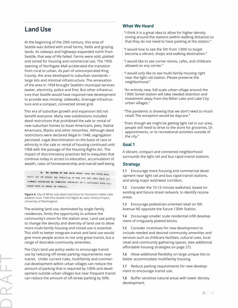
This era of suburban growth and expansion did not benefit everyone. Many new subdivisions included deed restrictions that prohibited the sale or rental of new suburban homes to Asian Americans, Jews, Native Americans, Blacks and other minorities. Although deed restrictions were declared illegal in 1948, segregation persisted. Legal discrimination on the basis of race or ethnicity in the sale or rental of housing continued until 1968 with the passage of the Housing Rights Act. The impact of discriminatory practices led to inequities that continue today in access to education, accumulation of wealth, rates of homeownership and overall well-being.
Figure 6. Clip of White only deed restriction for Huntoon’s Haller Lake Addition from 1940 (The Seattle Civil Rights & Labor History Project, University of Washington)
The existing land use, dominated by single family residences, limits the opportunity to achieve the community’s vision for the station area. Land use policy to change the density and diversity of land use to allow more multi-family housing and mixed use is essential. This shift to better integrate transit and land use would give more people access to not only great transit, but a range of desirable community amenities.
The City’s land use policy seeks to encourage transit use by reducing off-street parking requirements near transit. Under current rules, multifamily and commer-cial development within urban villages can reduce the amount of parking that is required by 100% and devel-opment outside urban villages but near frequent transit can reduce the amount of off-street parking by 50%.
What We Heard“I think it is a great idea to allow for higher density zoning around the stations (within walking distance) so that they do not need to have parking at the station.”
“I would love to see the 5th from 130th to target become a vibrant, shops and walking destination.”
“I would like to see corner stores, cafes, and childcare allowed on any corner.”
“I would only like to see multi-family housing right near the light rail station. Please preserve the neighborhood.”
“An entirely new, full-scale urban village around the 130th Street station will take needed attention and investment away from the Bitter Lake and Lake City urban villages.”
“The pandemic is showing that we don’t need so much retail! The exception would be daycare.”
“Even though we might be getting light rail in our area, people still need to drive to the store for groceries, Dr. appointments, or to recreational activities outside of the city.”
Goal 1A vibrant, compact and connected neighborhood surrounds the light rail and bus rapid transit stations.
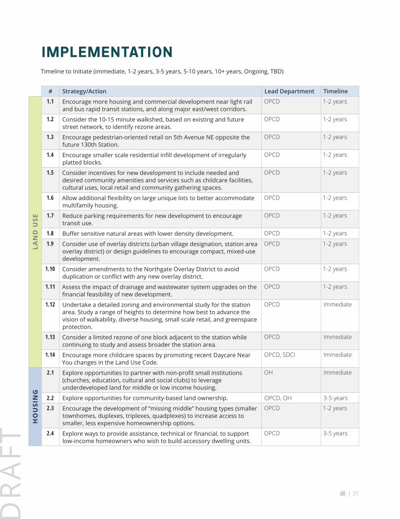
Strategy1.1 Encourage more housing and commercial devel-opment near light rail and bus rapid transit stations, and along major east/west corridors.
1.2 Consider the 10-15 minute walkshed, based on existing and future street network, to identify rezone areas.
1.3 Encourage pedestrian-oriented retail on 5th Avenue NE opposite the future 130th Station.
1.4 Encourage smaller scale residential infill develop-ment of irregularly platted blocks.
1.5 Consider incentives for new development to include needed and desired community amenities and services such as childcare facilities, cultural uses, local retail and community gathering spaces. (see additional affordable housing strategies on page 27).
1.6 Allow additional flexibility on large unique lots to better accommodate multifamily housing.
1.7 Reduce parking requirements for new develop-ment to encourage transit use.
1.8 Buffer sensitive natural areas with lower density development.
home | 14
DR
AFT
1.9 Consider use of overlay districts (urban village designation, station area overlay district) or design guidelines to encourage compact, mixed-use development.
1.10 Consider amendments to the Northgate Overlay District to avoid duplication or conflict with any new overlay district.
1.11 Assess the impact of drainage and wastewa-ter system upgrades on the financial feasibility of new development.
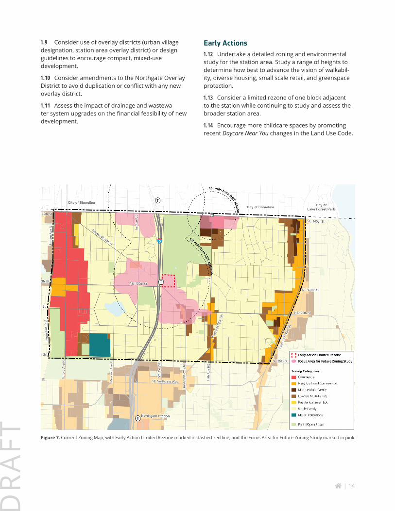
Early Actions1.12 Undertake a detailed zoning and environmental study for the station area. Study a range of heights to determine how best to advance the vision of walkabil-ity, diverse housing, small scale retail, and greenspace protection.
1.13 Consider a limited rezone of one block adjacent to the station while continuing to study and assess the broader station area.
1.14 Encourage more childcare spaces by promoting recent Daycare Near You changes in the Land Use Code.
Figure 7. Current Zoning Map, with Early Action Limited Rezone marked in dashed-red line, and the Focus Area for Future Zoning Study marked in pink.
home | 15
DR
AFT
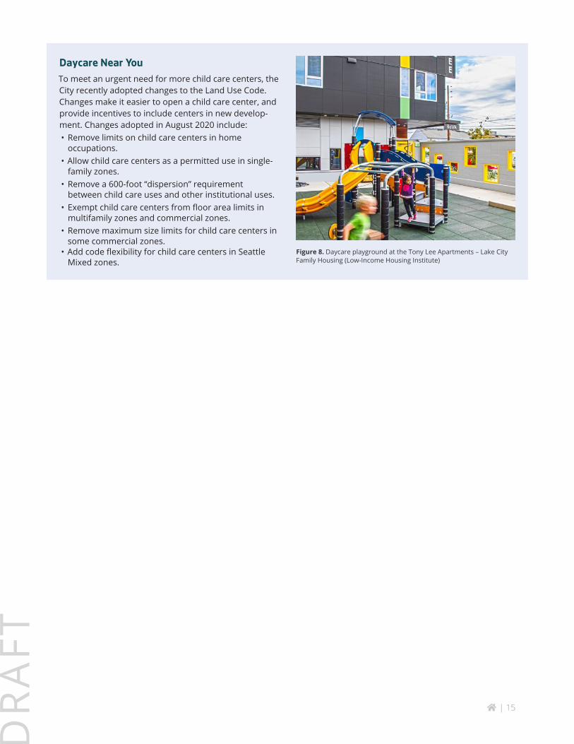
Daycare Near YouTo meet an urgent need for more child care centers, the City recently adopted changes to the Land Use Code. Changes make it easier to open a child care center, and provide incentives to include centers in new develop-ment. Changes adopted in August 2020 include:• Remove limits on child care centers in home
occupations.• Allow child care centers as a permitted use in single-
family zones. • Remove a 600-foot “dispersion” requirement
between child care uses and other institutional uses. • Exempt child care centers from floor area limits in
multifamily zones and commercial zones. • Remove maximum size limits for child care centers in
some commercial zones. • Add code flexibility for child care centers in Seattle
Mixed zones.
Figure 8. Daycare playground at the Tony Lee Apartments – Lake City Family Housing (Low-Income Housing Institute)
home | 16
DR
AFT
Housing (Additional goals and strategies specifically for affordable (rent and income-restricted) housing are on page 27)
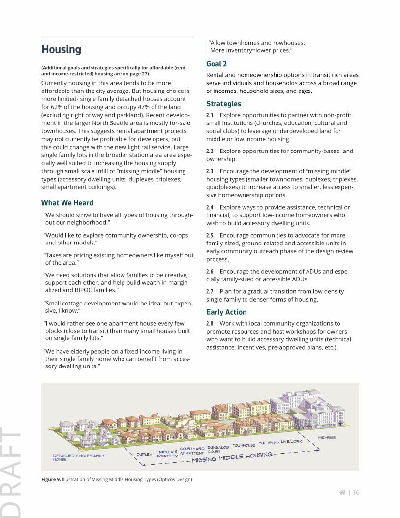
Currently housing in this area tends to be more affordable than the city average. But housing choice is more limited- single family detached houses account for 62% of the housing and occupy 47% of the land (excluding right of way and parkland). Recent develop-ment in the larger North Seattle area is mostly for-sale townhouses. This suggests rental apartment projects may not currently be profitable for developers, but this could change with the new light rail service. Large single family lots in the broader station area area espe-cially well suited to increasing the housing supply through small scale infill of “missing middle” housing types (accessory dwelling units, duplexes, triplexes, small apartment buildings).
What We Heard“We should strive to have all types of housing through-out our neighborhood.”
“Would like to explore community ownership, co-ops and other models.”
“Taxes are pricing existing homeowners like myself out of the area.”
“We need solutions that allow families to be creative, support each other, and help build wealth in margin-alized and BIPOC families.”
“Small cottage development would be ideal but expen-sive, I know.”
“I would rather see one apartment house every few blocks (close to transit) than many small houses built on single family lots.”
“We have elderly people on a fixed income living in their single family home who can benefit from acces-sory dwelling units.”
“Allow townhomes and rowhouses. More inventory=lower prices.”
Goal 2Rental and homeownership options in transit rich areas serve individuals and households across a broad range of incomes, household sizes, and ages.
Strategies2.1 Explore opportunities to partner with non-profit small institutions (churches, education, cultural and social clubs) to leverage underdeveloped land for middle or low income housing.
2.2 Explore opportunities for community-based land ownership.
2.3 Encourage the development of “missing middle” housing types (smaller townhomes, duplexes, triplexes, quadplexes) to increase access to smaller, less expen-sive homeownership options.
2.4 Explore ways to provide assistance, technical or financial, to support low-income homeowners who wish to build accessory dwelling units.
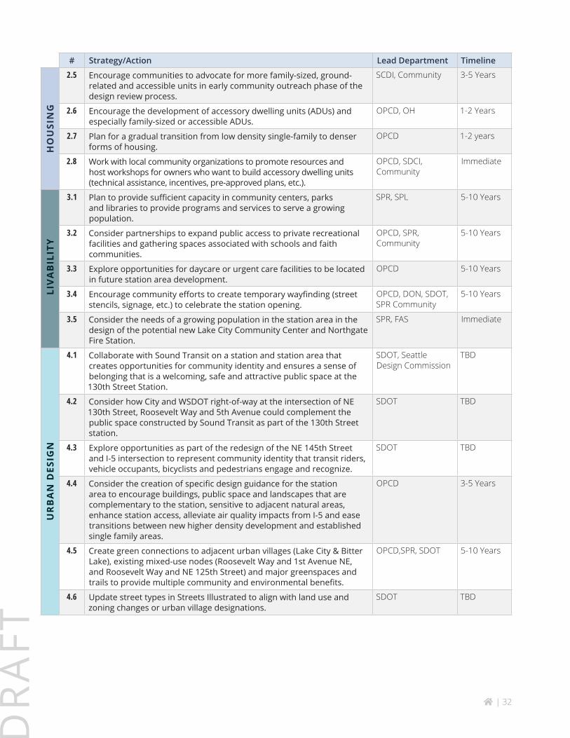
2.5 Encourage communities to advocate for more family-sized, ground-related and accessible units in early community outreach phase of the design review process.
2.6 Encourage the development of ADUs and espe-cially family-sized or accessible ADUs.
2.7 Plan for a gradual transition from low density single-family to denser forms of housing.
Early Action2.8 Work with local community organizations to promote resources and host workshops for owners who want to build accessory dwelling units (technical assistance, incentives, pre-approved plans, etc.).
Figure 9. Illustration of Missing Middle Housing Types (Opticos Design)
home | 17
DR
AFT
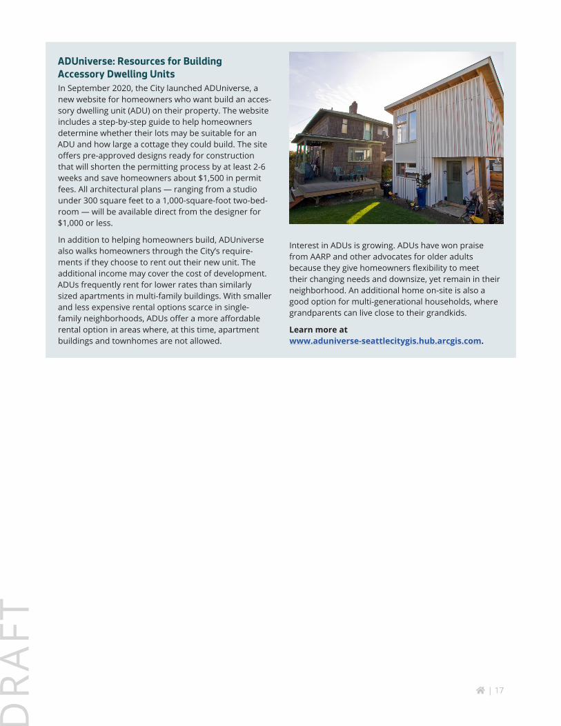
ADUniverse: Resources for Building Accessory Dwelling UnitsIn September 2020, the City launched ADUniverse, a new website for homeowners who want build an acces-sory dwelling unit (ADU) on their property. The website includes a step-by-step guide to help homeowners determine whether their lots may be suitable for an ADU and how large a cottage they could build. The site offers pre-approved designs ready for construction that will shorten the permitting process by at least 2-6 weeks and save homeowners about $1,500 in permit fees. All architectural plans — ranging from a studio under 300 square feet to a 1,000-square-foot two-bed-room — will be available direct from the designer for $1,000 or less.
In addition to helping homeowners build, ADUniverse also walks homeowners through the City’s require-ments if they choose to rent out their new unit. The additional income may cover the cost of development. ADUs frequently rent for lower rates than similarly sized apartments in multi-family buildings. With smaller and less expensive rental options scarce in single- family neighborhoods, ADUs offer a more affordable rental option in areas where, at this time, apartment buildings and townhomes are not allowed.
Interest in ADUs is growing. ADUs have won praise from AARP and other advocates for older adults because they give homeowners flexibility to meet their changing needs and downsize, yet remain in their neighborhood. An additional home on-site is also a good option for multi-generational households, where grandparents can live close to their grandkids.
Learn more at www.aduniverse-seattlecitygis.hub.arcgis.com.
home | 18
DR
AFT
Urban Design and Livability
The transition of the station area from a quiet single-family area to a walkable vibrant neighborhood will unfold over a long period of time. New develop-ment will bring new building forms and upgrade the street from suburban to urban with sidewalks, curbs, planting strips, and street trees. The 130th Street Station will create a major destination and identity for the neighborhood through its architecture, landscape design, public art and other public realm improvements. Neighborhood wayfinding will be key for highlighting routes to/ from the station. 145th Street is an opportu-nity to create a welcoming entrance to the City of Seattle that will be experienced by thousands of commuters and visitors from the communities north of Seattle.
As more people have opportunity to live near light rail and bus rapid transit stations, demand at nearby community facilities and services will increase. Existing community amenities within two miles of the station include multiple community centers, libraries and parks. A new fire station in Lake City opened in 2010, and studies are underway to replace the fire station in Northgate. Currently these facilities have sufficient capacity to accommodate an increase in population. Growth is likely to occur gradually as individual property owners make decisions to move, sell or redevelop their property. Future growth will continue to be monitored in citywide plans and capital improvement programs, and additional capacity added as needed.
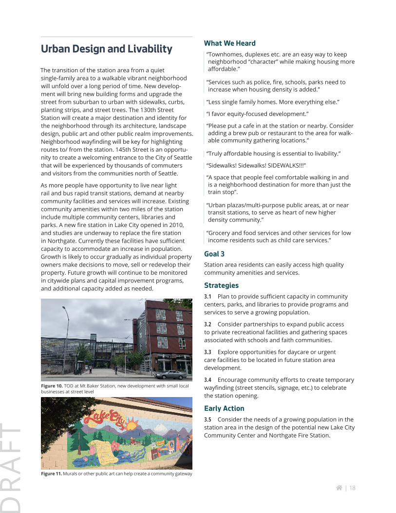
Figure 10. TOD at Mt Baker Station, new development with small local businesses at street level
Figure 11. Murals or other public art can help create a community gateway
What We Heard“Townhomes, duplexes etc. are an easy way to keep neighborhood “character” while making housing more affordable.”
“Services such as police, fire, schools, parks need to increase when housing density is added.”
“Less single family homes. More everything else.”
“I favor equity-focused development.”
“Please put a cafe in at the station or nearby. Consider adding a brew pub or restaurant to the area for walk-able community gathering locations.”
“Truly affordable housing is essential to livability.”
“Sidewalks! Sidewalks! SIDEWALKS!!!”
“A space that people feel comfortable walking in and is a neighborhood destination for more than just the train stop”.
“Urban plazas/multi-purpose public areas, at or near transit stations, to serve as heart of new higher density community.”
“Grocery and food services and other services for low income residents such as child care services.”
Goal 3Station area residents can easily access high quality community amenities and services.
Strategies3.1 Plan to provide sufficient capacity in community centers, parks, and libraries to provide programs and services to serve a growing population.
3.2 Consider partnerships to expand public access to private recreational facilities and gathering spaces associated with schools and faith communities.
3.3 Explore opportunities for daycare or urgent care facilities to be located in future station area development.
3.4 Encourage community efforts to create temporary wayfinding (street stencils, signage, etc.) to celebrate the station opening.
Early Action3.5 Consider the needs of a growing population in the station area in the design of the potential new Lake City Community Center and Northgate Fire Station.
home | 19
DR
AFT
Goal 4The neighborhood surrounding the station area has a distinct identity, high-quality public realm and well-de-signed buildings.
Strategies4.1 Collaborate with Sound Transit on a station and station area that creates opportunities for commu-nity identity and ensures a sense of belonging that is welcoming, safe and attractive public space at the 130th Street Station.
4.2 Consider how City and WSDOT right-of-way at the intersection of NE 130th Street, Roosevelt Way and 5th Avenue could complement the public space constructed by Sound Transit as part of the 130th Street station.
4.3 Explore opportunities as part of the redesign of the NE 145th Street and I-5 intersection to represent community identity that transit riders, vehicle occu-pants, bicyclists and pedestrians engage and recognize.
4.4 Consider the creation of specific design guid-ance for the station area to encourage buildings, public space and landscapes that are complementary to the station, sensitive to adjacent natural areas, enhance station access, alleviate air quality impacts from I-5 and ease transitions between new higher density develop-ment and established single family areas.
4.5 Create green connections to adjacent urban villages (Lake City & Bitter Lake), existing mixed-use nodes (Roosevelt Way and 1st Avenue NE, and Roosevelt Way and NE 125th Street) and major green-spaces and trails to provide multiple community and environmental benefits.
4.6 Update street types in Streets Illustrated to align with land use and zoning changes or urban village designations.
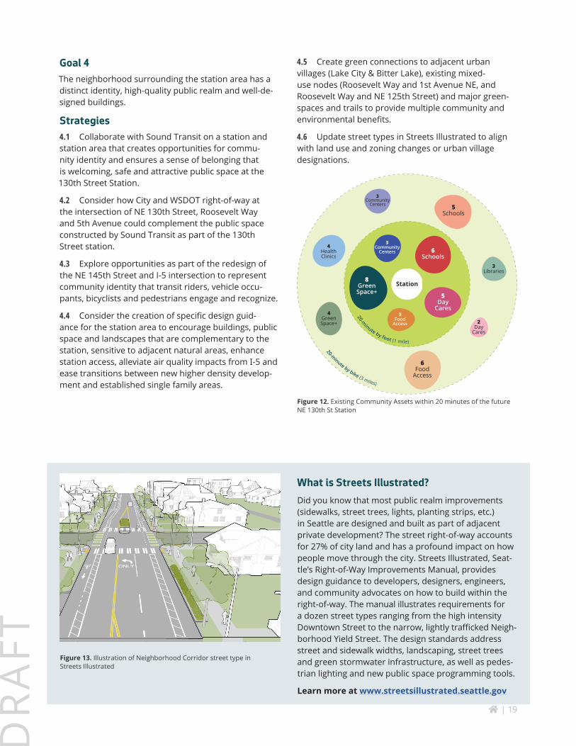
20-m
inute by foot (1 mile)
20-m
inute by bike (3 miles)
6Schools
8GreenSpace+ 5
DayCares
5Schools
3Libraries
4HealthClinics
2Day
Cares
4GreenSpace+
3Community
Centers
3Community
Centers
3Food
Access
6Food
Access
Station
Figure 12. Existing Community Assets within 20 minutes of the future NE 130th St Station
Figure 13. Illustration of Neighborhood Corridor street type in Streets Illustrated
What is Streets Illustrated?Did you know that most public realm improvements (sidewalks, street trees, lights, planting strips, etc.) in Seattle are designed and built as part of adjacent private development? The street right-of-way accounts for 27% of city land and has a profound impact on how people move through the city. Streets Illustrated, Seat-tle’s Right-of-Way Improvements Manual, provides design guidance to developers, designers, engineers, and community advocates on how to build within the right-of-way. The manual illustrates requirements for a dozen street types ranging from the high intensity Downtown Street to the narrow, lightly trafficked Neigh-borhood Yield Street. The design standards address street and sidewalk widths, landscaping, street trees and green stormwater infrastructure, as well as pedes-trian lighting and new public space programming tools.
Learn more at www.streetsillustrated.seattle.gov

home | 20
DR
AFT
Natural Environment
Natural features are defining characteristics of the neighborhood. Residents enjoy a variety of social and health benefits from greenspace and tree canopy. Notable natural features include Northacres Park, Jackson Park Golf Course, Licorice Fern Natural Area, and Haller Lake. The large swaths of public lands provide recreation, preserve forests, wetlands, lake, floodplains, and habitat, and produce an array of envi-ronmental services such as stormwater management to protect Thornton Creek. The high value placed on the environment is demonstrated by the hands-on community efforts to help manage and steward natural resources through a number of organizations which builds social capital. Some residential blocks, espe-cially those with steep slopes or near Thornton Creek, have dense tree canopy which adds to the greenness of the neighborhood. Maintaining these resources as the community grows and changes is a priority for the community.
What We Heard“Our old growth trees are so valuable in our fight against climate chaos.”
“This area has one of Seattle’s last old-growth forests that extends into the residential neighborhood.”
“Tear down the fences around the PUBLIC PARK called Jackson Park Golf Club and make it equally accessible to all Seattle residents for recreation and safe, green route to the Station locations.“
“Preserve and improve green space at Jackson Park to create calm, reflective natural area with added trees and paths, connecting the two station areas.”
Goal 5Heathy, attractive and sustainable open spaces bring together longtime and new residents and provide multiple benefits to a growing community.
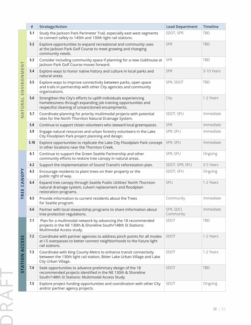
Strategies5.1 Study the Jackson Park Perimeter Trail, espe-cially east west segments to connect safely to 145th and 130th light rail stations (see Project #9 and 10 in NE 130th St & Shoreline South/148th St Stations: Multi-modal Access Study).
5.2 Explore opportunities to expand recreational and community uses at Jackson Park Golf Course to meet growing and changing community needs.
5.3 Consider including community space if planning for a new clubhouse at the Jackson Park Golf Course moves forward.
5.4 Explore ways to honor native history and culture in local parks and natural areas.
5.5 Explore ways to improve connectivity between parks, open space and trails in partnership with other City agencies and community organizations.
5.6 Strengthen the City’s efforts to uplift individu-als experiencing homelessness through expanding parks-based job training opportunities and respectful cleaning of unsanctioned encampments.
Early Actions5.7 Coordinate planning for priority multimodal projects with potential sites for the North Thornton Natural Drainage System.
5.8 Continue to support citizen volunteers who steward local greenspaces.
5.9 Engage natural resources and urban forestry volunteers in the Lake City Floodplain Park project plan-ning and design.
5.10 Explore opportunities to replicate the Lake City Floodplain Park concept in other locations near the Thornton Creek.
Goal 6Station area has healthy and resilient tree canopy.
Strategies6.1 Continue to support the Green Seattle Partnership and other community efforts to restore tree canopy in natural areas.
6.2 Support the implementation of Sound Transit’s reforestation plan.
6.3 Encourage residents to plant trees on their prop-erty or the public right of way.
6.4 Expand tree canopy through Seattle Public Utilities’ North Thornton natural drainage system, culvert replacement and floodplain restoration programs.
Early Actions
6.5 Provide information to current residents about the Trees for Seattle program.
6.6 Partner with local stewardship programs to share information about tree protection regulations.

home | 21
DR
AFT
Figure 14. This site will be transformed into a public park that will be a mix of floodplain habitat and and urban greenspace. (Seattle Public Utilities)
downstream flooding, improved water quality, reduced erosion and sedimentation, improved creek habitat for fish and aquatic life, greater system resiliency due to lower stream velocities, easier maintenance and future replacement of the undersized NE 125th culvert and increased public access to greenspace. Over time the site will become more important for fish habitat as culverts that block fish passage are removed.
Seattle Parks and Recreation and Seattle Public Utilities jointly purchased the site to create a public greenspace and restore the site for multiple benefits. After restoration is complete, Seattle Public Utilities will manage the in-stream habitat while Seattle Parks and Recreation will manage the upland habitat. Mid Sound Fisheries Enhancement Group will lead public engagement and manage the development of conceptual designs for the site.
Lake City Floodplain Park ProjectThornton Creek is a highly urbanized creek that suffers from frequent flooding events, poor water quality, and high peak flows. Chronic flooding has caused damage to public infrastructure and private property. Lake City is a highly diverse mixed-use neighborhood that has a growing multifamily residential housing and pedestrian retail and services core but lacks urban greenspace. Past neighborhood planning has identified Thornton Creek as a feature of community pride and has prior-itized improving visual and physical access to the creek. The privately-owned parcel was listed for sale in 2018 and quickly identified by the community as a high prior-ity to protect and restore.
The site area includes approximately 200 linear ft of stream, ~21,000 sq. ft of potential floodplain habitat, and ~19,000 sq. ft of upland habitat. Restoration of the site will create multiple benefits including decreased

home | 22
DR
AFT
HOW WE MOVE AROUND(See NE 130th & Shoreline South/148th St Stations: Multimodal Access Study for more detailed transportation infrastructure recommendations)
Goal 7People experience safety and convenience when walking, bicycling, and taking transit to the future light rail stations and bus rapid transit.
Strategies7.1 Plan for a multimodal network by advancing the 18 recommended projects in the NE 130th & Shoreline South/148th St Stations: Multimodal Access Study.
7.2 Coordinate with partner agencies to address pinch points for all modes at I-5 overpasses to better connect neighborhoods to the future light rail stations.
7.3 Coordinate with King County Metro to enhance transit connectivity between the 130th light rail station, Bitter Lake Urban Village and Lake City Urban Village.
Early Actions7.4 Seek opportunities to advance preliminary design of the 18 high priority recommended projects iden-tified in the NE 130th & Shoreline South/148th St Stations: Multimodal Access Study.
7.5 Explore project funding opportunities and coordi-nation with other City and/or partner agency projects.
Station Access
How we access the future light rail station by bike, walking, and taking transit.
The introduction of light rail service will boost regional mobility for North Seattle. But the area will continue to be challenged by its 1950’s auto-oriented pattern of urban development- few sidewalks, interrupted street grid, large block sizes, and informal on-street parking. Streets built in this era rarely included marked or separated bicycle lanes. I-5 and Jackson Park Golf Course present additional connectivity challenges. This pattern hampers safe pedestrian and bike access to the future stations and other community destinations and remains a top issue for many neighborhoods in Seattle north of 85th Street.
What We Heard“We need more sidewalks, bike facilities, and safer street crossings in the neighborhood to get to the new light rail station”
“I would want to walk or bike to the 130th St light rail station if there were safer connections”
“The NE 130th St overpass is not pleasant for walking and biking”
“Improve the trail around the golf course – especially along 145th and the trail on the south side of the park.”
Transitioning a neighborhood to be less reliant on cars requires better infrastructure and a shift in thinking about how to regulate on-street and off-street parking in ways that encourage walking, biking and transit use.
home | 23
DR
AFT
Neighborhood Mobility
Goal 8Future transportation investments complement future land use changes.
Strategies8.1 Coordinate transportation investments with private development.
8.2 Strengthen east-west connections for people walking, biking, and taking transit between urban villages.
8.3 Connect key community destinations like parks, schools, and businesses with multimodal improve-ments to enhance neighborhood circulation.
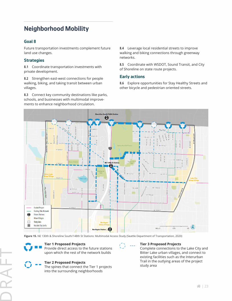
Figure 15. NE 130th & Shoreline South/148th St Stations: Multimodal Access Study (Seattle Department of Transportation, 2020)
8.4 Leverage local residential streets to improve walking and biking connections through greenway networks.
8.5 Coordinate with WSDOT, Sound Transit, and City of Shoreline on state route projects.
Early actions8.6 Explore opportunities for Stay Healthy Streets and other bicycle and pedestrian oriented streets.
Tier 3 Proposed Projects Complete connections to the Lake City and Bitter Lake urban villages, and connect to existing facilities such as the Interurban Trail in the outlying areas of the project study area
Tier 2 Proposed Projects The spines that connect the Tier 1 projects into the surrounding neighborhoods
Tier 1 Proposed ProjectsProvide direct access to the future stations upon which the rest of the network builds
home | 24
DR
AFT
Parking
When light rail service comes to a neighborhood it greatly increases options for travelling to regional desti-nations quickly and cheaply. People who live close by tend to drive less and use transit more. Gener-ally, Seattle does not use park-and-ride lots to increase ridership. The City’s policy encourages land close to stations to be used for housing, retail or community uses. Although Sound Transit has not included park-and-ride as part of its station plan for the 130th Street Station, people can use park-and-ride at the Shoreline South or Northgate stations a short distance away.
Within neighborhoods adjacent to the station, The City will study parking regulations to discourage commut-ers from parking all day on local streets or in lots at City parks, libraries and other public facilities. Potential regulations ensure that parking is available for visitors, shoppers, and local residents. The City may poten-tially modify land use regulations to discourage private commuter parking lots. The 46-space South Jackson Park Park-and-Ride lot on 5th Avenue NE, owned by WDOT and leased by King County Metro, was used for carpools and vanpools, but is closed for light rail construction. Its future use is yet to be decided but it could play a role in supporting local mobility.
Goal 9Parking in the station area is minimized to encourage walking, biking and transit use.
Strategy9.1 Coordinate with King County Metro on a future plan for the South Jackson Park Park-and-Ride lot on 5th Ave NE.
9.2 Evaluate potential parking restrictions at public spaces near light rail stations (Jackson Park Golf Course, Northacres Park, Helene Madison Pool, Jackson Park P-Patch) to increase parking availability for visitors and ensure parking is not used by all-day commuters.
9.3 Discourage the use of private parking lots for park-and-ride within a half mile of the station. (e.g. church or school properties).
9.4 Initiate a community parking study two years before the LRT or BRT stations open to explore the need for a restricted parking zone (RPZ), on-street parking restrictions and loading needs.
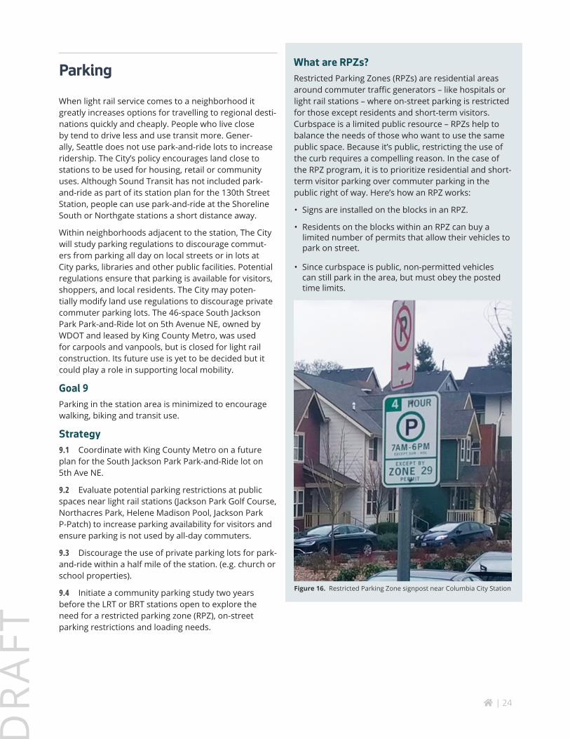
What are RPZs?Restricted Parking Zones (RPZs) are residential areas around commuter traffic generators – like hospitals or light rail stations – where on-street parking is restricted for those except residents and short-term visitors. Curbspace is a limited public resource – RPZs help to balance the needs of those who want to use the same public space. Because it’s public, restricting the use of the curb requires a compelling reason. In the case of the RPZ program, it is to prioritize residential and short- term visitor parking over commuter parking in the public right of way. Here’s how an RPZ works:
• Signs are installed on the blocks in an RPZ.
• Residents on the blocks within an RPZ can buy a limited number of permits that allow their vehicles to park on street.
• Since curbspace is public, non-permitted vehicles can still park in the area, but must obey the posted time limits.
Figure 16. Restricted Parking Zone signpost near Columbia City Station
home | 25
DR
AFT
T
T
Public/Private Parcels with No Development Expected
City-Owned Open Space
Publicly-Owned
No Development Allowed (i.e. zone prohibits, difficult site conditions)
Mixed Use / Commercial with Potential CapacitySignificantly Under Developed (under 20%)
Under Developed (21% - 40%)
Moderately Developed (41% - 80%)
Residential (SF/Low-rise MF) with Potential Capacity
Significantly Under Developed (under 20%)
Under Developed (21% - 40%)
Moderately Developed (41% - 80%)
WHERE CHANGE COULD HAPPEN FIRST
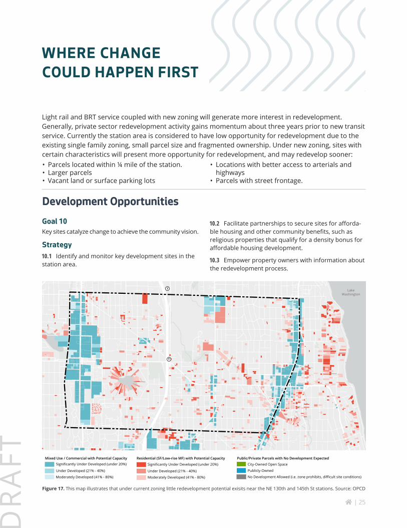
Light rail and BRT service coupled with new zoning will generate more interest in redevelopment. Generally, private sector redevelopment activity gains momentum about three years prior to new transit service. Currently the station area is considered to have low opportunity for redevelopment due to the existing single family zoning, small parcel size and fragmented ownership. Under new zoning, sites with certain characteristics will present more opportunity for redevelopment, and may redevelop sooner:
Development OpportunitiesGoal 10Key sites catalyze change to achieve the community vision.
Strategy10.1 Identify and monitor key development sites in the station area.
10.2 Facilitate partnerships to secure sites for afforda-ble housing and other community benefits, such as religious properties that qualify for a density bonus for affordable housing development.
10.3 Empower property owners with information about the redevelopment process.
• Parcels located within ¼ mile of the station.• Larger parcels• Vacant land or surface parking lots
• Locations with better access to arterials and highways
• Parcels with street frontage.
Figure 17. This map illustrates that under current zoning little redevelopment potential exisits near the NE 130th and 145th St stations. Source: OPCD
Lake Washington
home | 26
DR
AFT
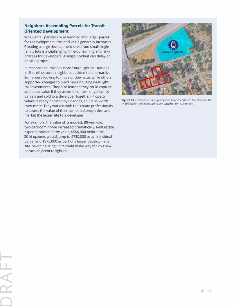
Neighbors Assembling Parcels for Transit Oriented DevelopmentWhen small parcels are assembled into larger parcel for redevelopment, the land value generally increases. Creating a large development sites from small single family lots is a challenging, time-consuming and risky process for developers. A single holdout can delay or derail a project.
In response to upzones near future light rail stations in Shoreline, some neighbors decided to be proactive. Some were looking to move or downsize, while others supported changes to build more housing near light rail investments. They also learned they could capture additional value if they assembled their single family parcels and sold to a developer together. Property values, already boosted by upzones, could be worth even more. They worked with real estate professionals to assess the value of their combined properties, and market the larger site to a developer.
For example, the value of a modest, 80-year-old, two-bedroom home increased dramatically. Real estate experts estimated the value, $500,000 before the 2016 upzone, would jump to $730,000 as an individual parcel and $875,000 as part of a larger development site. Seven housing units could make way for 250 new homes adjacent to light rail.
Figure 18. Owners of seven properties near the future Shoreline South 148th Station collaborated to sell together for a premium.
home | 27
DR
AFT
HOW TO MAKE CHANGE EQUITABLE
What We Heard
“Glad to share my neighborhood with low income housing.”
“Make affordable housing available to everyone who needs it.”
“Would like to explore community ownership, co-ops and other models.”
“We need a more comprehensive public housing policy.”
“Affordable housing needs to be diverse. We have immigrants and refugees with large families living in one-bedroom apartments.”
Goal 11People of limited means and marginalized populations have affordable housing opportunities close to light rail and bus rapid transit.
Strategy11.1 Prioritize the station area for affordable housing investments.
11.2 Encourage religious institutions to consider affordable housing development on surplus lands.
11.3 Support capacity building of community organiza-tions and social service providers in North Seattle (e.g. Lake City Collaborative, Children’s Aid Society, Literacy Source, Mary’s Place) to better connect their constituents to affordable housing opportunities in the station area.
11.4 Share information with Seattle Public Schools about affordable housing developments to promote and market affordable housing to eligible families within the service area of local schools.
Equitable development means public and private investments, programs, and policies in neighborhoods that take into account past history and current conditions to meet the needs of marginalized populations. It is development that reduces disparities. Quality of life outcomes such as access to quality education, living wage employment, healthy environment, affordable housing and transportation, are equitably distributed for the people currently living and working here, as well as for new people moving in. Station area planning can help ensure that the public and private investments near future transit stations include equitable development.
Affordable Housing
One of the City’s guiding principles for station area planning and development is to “provide housing choices to a full range of incomes near high capacity transit (light rail and bus rapid transit stations).”
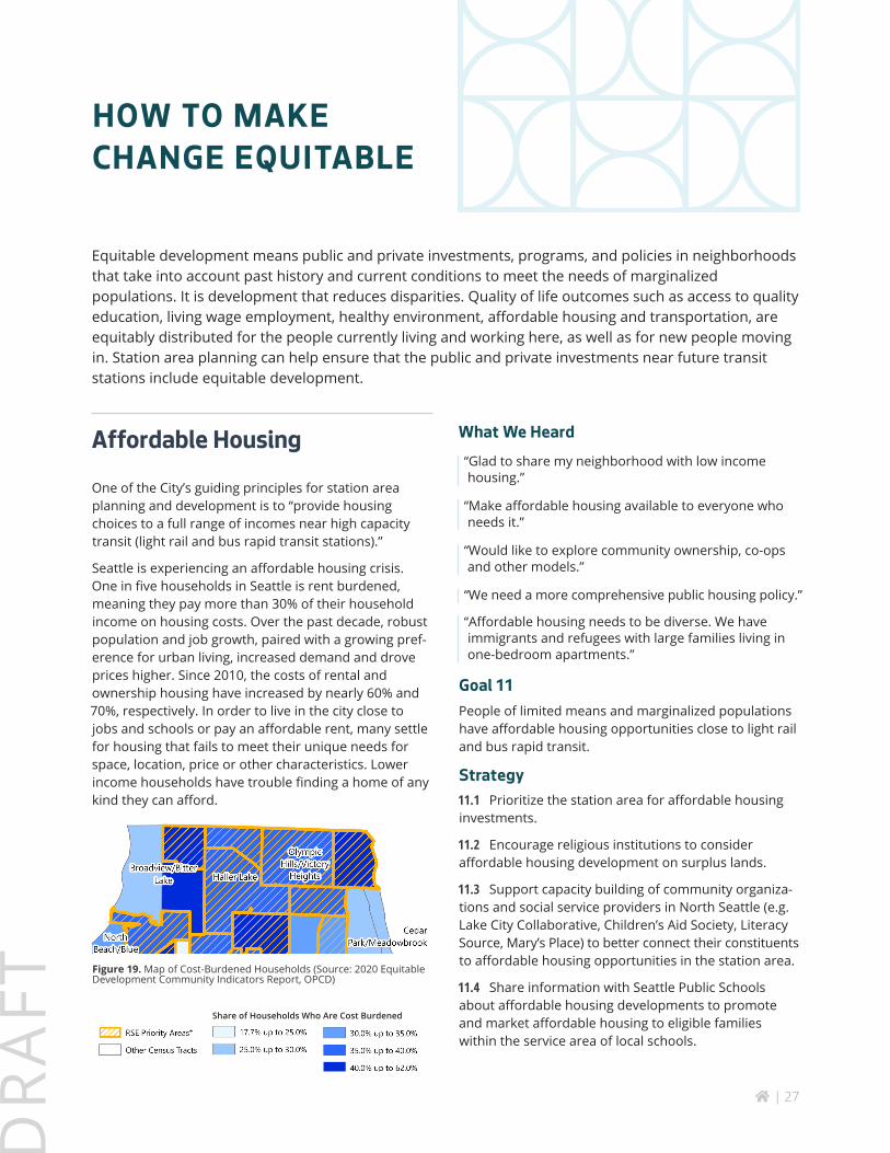
Seattle is experiencing an affordable housing crisis. One in five households in Seattle is rent burdened, meaning they pay more than 30% of their household income on housing costs. Over the past decade, robust population and job growth, paired with a growing pref-erence for urban living, increased demand and drove prices higher. Since 2010, the costs of rental and ownership housing have increased by nearly 60% and 70%, respectively. In order to live in the city close to jobs and schools or pay an affordable rent, many settle for housing that fails to meet their unique needs for space, location, price or other characteristics. Lower income households have trouble finding a home of any kind they can afford.
Figure 19. Map of Cost-Burdened Households (Source: 2020 Equitable Development Community Indicators Report, OPCD)
Share of Households Who Are Cost Burdened

home | 28
DR
AFT
Sound Transit’s Equitable TOD ProgramSound Transit partners with private and non-profit developers to build transit oriented development (TOD), where housing is affordable to a range of income levels, as well as new retail, restaurants, offices, and community spaces, contribute to creating vibrant neighborhoods with direct access to transit. Transit construction requires Sound Transit to purchase land for building stations, installing track, and for staging. When construction is finished and the project opens, the agency no longer needs some of this land.
In May 2018, the Sound Transit Board officially recom-mitted the agency to facilitate TOD on this surplus property. Washington’s State Statute RCW 81.112.350 requires Sound Transit to offer 80 percent of its surplus property that is suitable for housing to qualified entities (local governments, housing authorities and nonprofit developers) to develop affordable housing. At least 80 percent of the housing units constructed must be affordable to those earning 80 percent of the area median income.
Although Sound Transit will have no surplus land at the 130th Street Station, this program brought affordable housing to the Roosevelt Station. Cedar Crossing will provide approximately 254 affordable housing units on a 1.2-acre property adjacent to the north station build-ing at Roosevelt Station, including approximately 87 two- and three-bedroom units for larger families. The project will set aside housing for children with high medical needs and their families through a partner-ship with Seattle Children’s/Mary’s Place. It will also offer housing to veterans and their families as well as to senior veterans. A public plaza, child-care center and ground-floor retail will provide services for transit riders and the broader neighborhood.
Figure 21. Cedars Crossing TOD at Roosevelt Station built on Sound Transit surplus land, will have 254 affordable housing units (Sound Transit)
11.5 Work with Sound Transit to explore “Equitable TOD” opportunities for any remnant parcels along Lynwood Link alignment (between Northgate and 130th Street Station) or the 145th BRT corridor.
11.6 Explore partnerships with Seattle Housing Authority to increase supply of affordable housing in station area.
11.7 Explore opportunities for affordable housing developers to build rent-restricted accessory dwelling units in the area.
11.8 Maximize zoned development potential for affordable housing development sites.
11.9 Educate tenants and property owners about Notice of Intent to Sell, which requires property owners to provide the City with information about the inten-tion to sell a residential property with at least one unit rented at 80% of Area Median Income or below. Notice of Intent to Sell allows for the City and partners to deploy a range of property preservation tools, such as acquisition.
Early Actions
11.10 Work with local community organizations to support the development of affordable housing in the station area.
Figure 20. Location of Existing Rent- and Income-Restricted Units
Olympic Hills/Olympic Hills/Victory HeightsVictory Heights
Haller LakeHaller Lake
Cedar Park/ Cedar Park/ MeadowbrookMeadowbrook
home | 29
DR
AFT
Displacement Mitigation
As one of the country’s fastest growing large cities over the past decade, Seattle saw rapidly escalating rents and housing prices. This has placed low-income house-holds and BIPOC communities at increasing risk of displacement. In response, the City is working to help residents, community organizations, and businesses to stay in their neighborhoods through many anti-displace-ment policies and programs, a few of which include:
• The Equitable Development Initiative fund, which supports community-led organizations that are combating displacement and helping small BIPOC businesses respond to economic disruption from the COVID-19 pandemic. In North Seattle, this funding currently supports the Lake City Collective.
• A Community Preference Policy, which enables City-funded housing in areas with high displacement risk to prioritize prospective tenants who have longstand-ing links to the neighborhood.
• A moratorium on residential, nonprofit, and small business evictions, along with other emergency protections and relief to mitigate economic impacts of the COVID-19 pandemic.
Goal 12Current residents and businesses can afford to remain in the station area and enjoy benefits of enhanced transit service.
Strategies12.1 Continue to monitor indicators of displacement risk in the station area, especially single home housing flipping.
12.2 Require a Community Preference Policy for City-funded affordable housing in the station area.
12.3 Work with Lake City Together, North Seattle Chamber or other business associations to relocate local businesses displaced by redevelopment.
12.4 Continue to direct City resources to support capac-ity building for community organizations working to mitigate displacement in North Seattle through the Equitable Development Initiative or similar programs.
Measuring DisplacementCurrently the City is monitoring and mapping following various indicators of displacement risk:
• Housing cost burden and supply of affordable housing, especially rentals.
• Tenant relocation, condo conversions, and foreclosures.
• Early design guidance applications, construction permits, increases in sale prices, and
• Home flipping is an indicator of displacement.
About 62% of the housing units in the 130th and 145th station area are detached “single family” units. Over the past five years the station area has seen an above average number of single family home flips, which refer to homes that were sold twice within a year and increased in price significantly between sales.
This indicates the market is seeing opportunities for short term profits, and could affect current renters of single-family homes in the station area as well as the ability for low- and moderate-income families to move into one of these homes in the future.
More information about the City data on displace-ment risk indicators can be found here: https://population-and-demographics-seattlecitygis.hub.arcgis.com/pages/displacement-risk
home | 30
DR
AFT
Access to Opportunity
The Seattle 2035 Growth and Equity Report (May 2016) defines access to opportunity as “Living within walking distance or with transit access to services, employment opportunities, amenities, and other key determinants of social, economic, and physical well-being.” The intro-duction of LRT and BRT service will increase access to opportunity in this area, which could change outcomes for lower income and BIPOC communities who have yet to benefit from Seattle’s recent prosperity.
Most local public schools that serve residents in the station area have been renovated or replaced. A new replacement building for Northgate Elementary School is scheduled to be completed for the 2023-24 school year.
An increased supply of affordable housing in the station area paired with high capacity transit (LRT and BRT) will greatly improve access to higher education institutions and major employment centers. Low- income households, marginalized and BIPOC communities can leverage this access to achieve better quality of life outcomes.
• Future Estimated Time to Educational Institutions: Northgate/North Seattle Community College (2 min), UW Main campus (8 min), UW Bothell campus (22 min)
• Future Estimated Time to Major Employment Centers: Northgate (2 min), University District (8 min), Down-town Seattle (15 min), Duwamish Industrial District (26 min), Sea-Tac Airport (45 min)
Goal 13
Residents have excellent access to regional educational and employment opportunities.
Strategy13.1 Work with Seattle Housing Authority and other institutions to replicate the success of Creating Moves to Opportunity program.
13.2 Promote the station area to low-income house-holds as a high opportunity area.
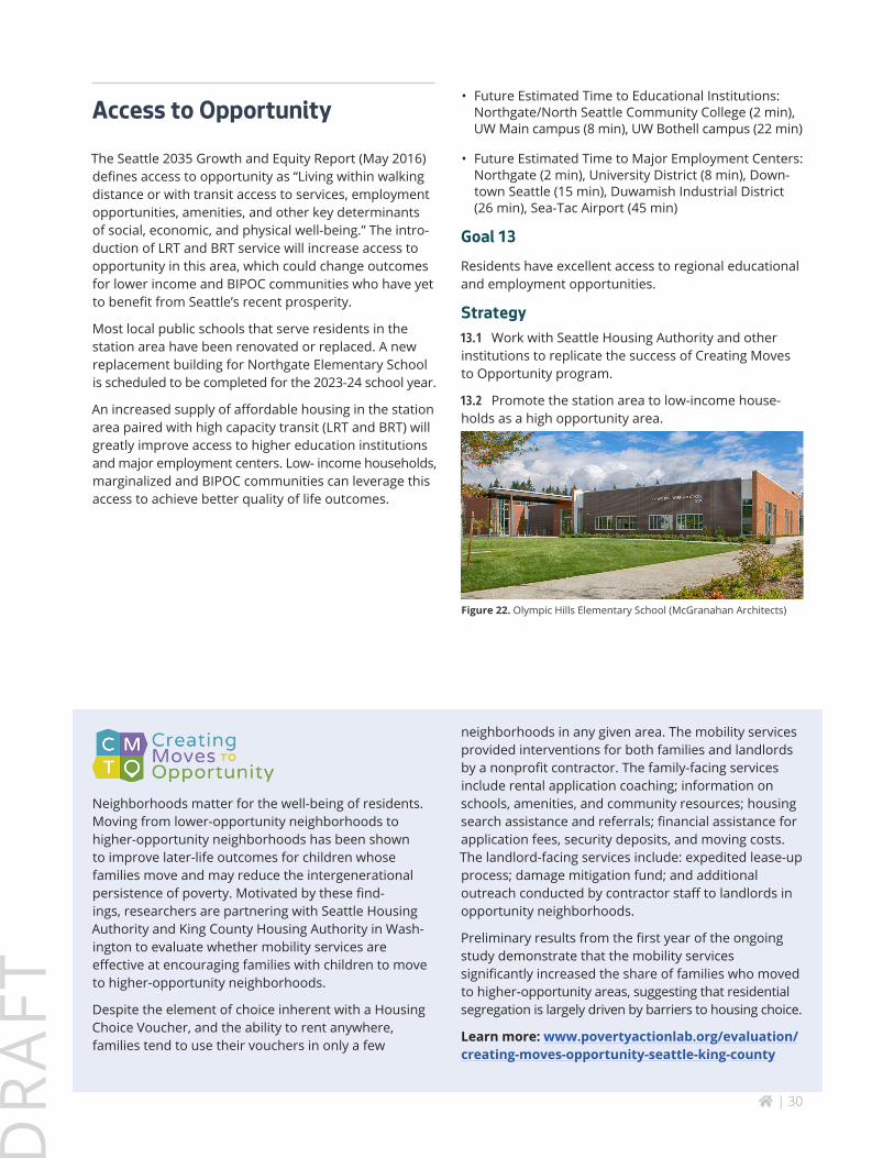
Figure 22. Olympic Hills Elementary School (McGranahan Architects)
Neighborhoods matter for the well-being of residents. Moving from lower-opportunity neighborhoods to higher-opportunity neighborhoods has been shown to improve later-life outcomes for children whose families move and may reduce the intergenerational persistence of poverty. Motivated by these find-ings, researchers are partnering with Seattle Housing Authority and King County Housing Authority in Wash-ington to evaluate whether mobility services are effective at encouraging families with children to move to higher-opportunity neighborhoods.
Despite the element of choice inherent with a Housing Choice Voucher, and the ability to rent anywhere, families tend to use their vouchers in only a few
neighborhoods in any given area. The mobility services provided interventions for both families and landlords by a nonprofit contractor. The family-facing services include rental application coaching; information on schools, amenities, and community resources; housing search assistance and referrals; financial assistance for application fees, security deposits, and moving costs. The landlord-facing services include: expedited lease-up process; damage mitigation fund; and additional outreach conducted by contractor staff to landlords in opportunity neighborhoods.
Preliminary results from the first year of the ongoing study demonstrate that the mobility services significantly increased the share of families who moved to higher-opportunity areas, suggesting that residential segregation is largely driven by barriers to housing choice.
Learn more: www.povertyactionlab.org/evaluation/creating-moves-opportunity-seattle-king-county
home | 31
DR
AFT
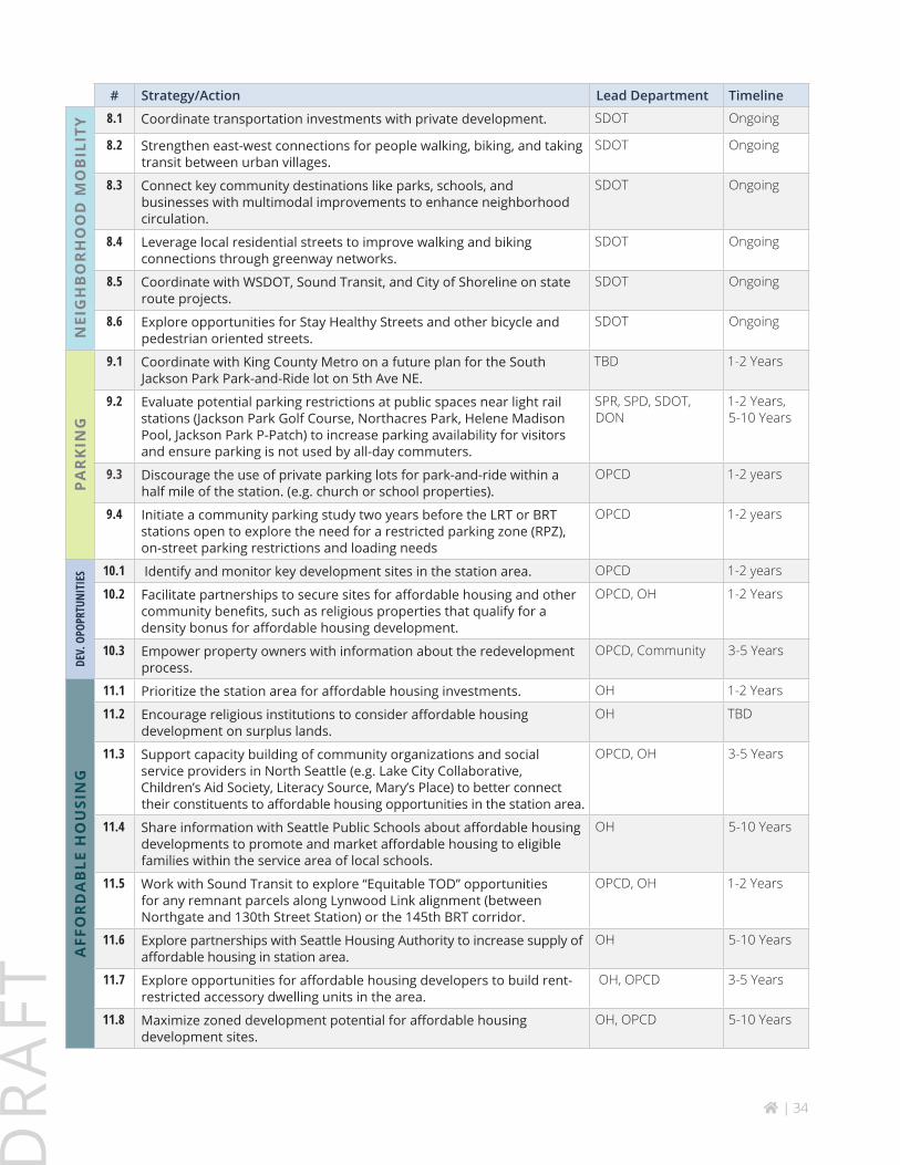
IMPLEMENTATIONTimeline to Initiate (immediate, 1-2 years, 3-5 years, 5-10 years, 10+ years, Ongoing, TBD)
# Strategy/Action Lead Department Timeline
LAN
D U
SE
1.1 Encourage more housing and commercial development near light rail and bus rapid transit stations, and along major east/west corridors.
OPCD 1-2 years
1.2 Consider the 10-15 minute walkshed, based on existing and future street network, to identify rezone areas.
OPCD 1-2 years
1.3 Encourage pedestrian-oriented retail on 5th Avenue NE opposite the future 130th Station.
OPCD 1-2 years
1.4 Encourage smaller scale residential infill development of irregularly platted blocks.
OPCD 1-2 years
1.5 Consider incentives for new development to include needed and desired community amenities and services such as childcare facilities, cultural uses, local retail and community gathering spaces.
OPCD 1-2 years
1.6 Allow additional flexibility on large unique lots to better accommodate multifamily housing.
OPCD 1-2 years
1.7 Reduce parking requirements for new development to encourage transit use.
OPCD 1-2 years
1.8 Buffer sensitive natural areas with lower density development. OPCD 1-2 years
1.9 Consider use of overlay districts (urban village designation, station area overlay district) or design guidelines to encourage compact, mixed-use development.
OPCD 1-2 years
1.10 Consider amendments to the Northgate Overlay District to avoid duplication or conflict with any new overlay district.
OPCD 1-2 years
1.11 Assess the impact of drainage and wastewater system upgrades on the financial feasibility of new development.
OPCD 1-2 years
1.12 Undertake a detailed zoning and environmental study for the station area. Study a range of heights to determine how best to advance the vision of walkability, diverse housing, small scale retail, and greenspace protection.
OPCD Immediate
1.13 Consider a limited rezone of one block adjacent to the station while continuing to study and assess broader the station area.
OPCD Immediate
1.14 Encourage more childcare spaces by promoting recent Daycare Near You changes in the Land Use Code.
OPCD, SDCI Immediate
HO
USI
NG
2.1 Explore opportunities to partner with non-profit small institutions (churches, education, cultural and social clubs) to leverage underdeveloped land for middle or low income housing.
OH Immediate
2.2 Explore opportunities for community-based land ownership. OPCD, OH 3-5 years
2.3 Encourage the development of “missing middle” housing types (smaller townhomes, duplexes, triplexes, quadplexes) to increase access to smaller, less expensive homeownership options.
OPCD 1-2 years
2.4 Explore ways to provide assistance, technical or financial, to support low-income homeowners who wish to build accessory dwelling units.
OPCD 3-5 years
home | 32
DR
AFT
# Strategy/Action Lead Department TimelineH
OU
SIN
G
2.5 Encourage communities to advocate for more family-sized, ground-related and accessible units in early community outreach phase of the design review process.
SCDI, Community 3-5 Years
2.6 Encourage the development of accessory dwelling units (ADUs) and especially family-sized or accessible ADUs.
OPCD, OH 1-2 Years
2.7 Plan for a gradual transition from low density single-family to denser forms of housing.
OPCD 1-2 years
2.8 Work with local community organizations to promote resources and host workshops for owners who want to build accessory dwelling units (technical assistance, incentives, pre-approved plans, etc.).
OPCD, SDCI, Community
Immediate
LIV
AB
ILIT
Y
3.1 Plan to provide sufficient capacity in community centers, parks and libraries to provide programs and services to serve a growing population.
SPR, SPL 5-10 Years
3.2 Consider partnerships to expand public access to private recreational facilities and gathering spaces associated with schools and faith communities.
OPCD, SPR, Community
5-10 Years
3.3 Explore opportunities for daycare or urgent care facilities to be located in future station area development.
OPCD 5-10 Years
3.4 Encourage community efforts to create temporary wayfinding (street stencils, signage, etc.) to celebrate the station opening.
OPCD, DON, SDOT, SPR Community
5-10 Years
3.5 Consider the needs of a growing population in the station area in the design of the potential new Lake City Community Center and Northgate Fire Station.
SPR, FAS Immediate
UR
BA
N D
ESIG
N
4.1 Collaborate with Sound Transit on a station and station area that creates opportunities for community identity and ensures a sense of belonging that is a welcoming, safe and attractive public space at the 130th Street Station.
SDOT, Seattle Design Commission
TBD
4.2 Consider how City and WSDOT right-of-way at the intersection of NE 130th Street, Roosevelt Way and 5th Avenue could complement the public space constructed by Sound Transit as part of the 130th Street station.
SDOT TBD
4.3 Explore opportunities as part of the redesign of the NE 145th Street and I-5 intersection to represent community identity that transit riders, vehicle occupants, bicyclists and pedestrians engage and recognize.
SDOT TBD
4.4 Consider the creation of specific design guidance for the station area to encourage buildings, public space and landscapes that are complementary to the station, sensitive to adjacent natural areas, enhance station access, alleviate air quality impacts from I-5 and ease transitions between new higher density development and established single family areas.
OPCD 3-5 Years
4.5 Create green connections to adjacent urban villages (Lake City & Bitter Lake), existing mixed-use nodes (Roosevelt Way and 1st Avenue NE, and Roosevelt Way and NE 125th Street) and major greenspaces and trails to provide multiple community and environmental benefits.
OPCD,SPR, SDOT 5-10 Years
4.6 Update street types in Streets Illustrated to align with land use and zoning changes or urban village designations.
SDOT TBD
home | 33
DR
AFT
# Strategy/Action Lead Department TimelineN
ATU
RA
L EN
VIR
ON
MEN
T
5.1 Study the Jackson Park Perimeter Trail, especially east west segments to connect safely to 145th and 130th light rail stations.
SDOT, SPR TBD
5.2 Explore opportunities to expand recreational and community uses at the Jackson Park Golf Course to meet growing and changing community needs.
SPR TBD
5.3 Consider including community space if planning for a new clubhouse at Jackson Park Golf Course moves forward.
SPR TBD
5.4 Explore ways to honor native history and culture in local parks and natural areas.
SPR 5-10 Years
5.5 Explore ways to improve connectivity between parks, open space and trails in partnership with other City agencies and community organizations.
SPR, SDOT TBD
5.6 Strengthen the City’s efforts to uplift individuals experiencing homelessness through expanding job training opportunities and respectful cleaning of unsanctioned encampments.
City 1-2 Years
5.7 Coordinate planning for priority multimodal projects with potential sites for the North Thornton Natural Drainage System.
SDOT, SPU Immediate
5.8 Continue to support citizen volunteers who steward local greenspaces. SPR Immediate
5.9 Engage natural resources and urban forestry volunteers in the Lake City Floodplain Park project planning and design.
SPR, SPU Immediate
5.10 Explore opportunities to replicate the Lake City Floodplain Park concept in other locations near the Thornton Creek.
SPR, SPU Immediate
TREE
CA
NO
PY
6.1 Continue to support the Green Seattle Partnership and other community efforts to restore tree canopy in natural areas.
SPR, SPU Ongoing
6.2 Support the implementation of Sound Transit’s reforestation plan. SDOT, SPR, SPU 3-5 Years
6.3 Encourage residents to plant trees on their property or the public right of way.
SDOT, SPU Ongoing
6.4 Expand tree canopy through Seattle Public Utilities’ North Thornton natural drainage system, culvert replacement and floodplain restoration programs.
SPU 1-2 Years
6.5 Provide information to current residents about the Trees for Seattle program.
Community Immediate
6.6 Partner with local stewardship programs to share information about tree protection regulations.
SPR, SDCI, Community
Immediate
STA
TIO
N A
CC
ESS
7.1 Plan for a multimodal network by advancing the 18 recommended projects in the NE 130th & Shoreline South/148th St Stations: Multimodal Access study.
SDOT TBD
7.2 Coordinate with partner agencies to address pinch points for all modes at I-5 overpasses to better connect neighborhoods to the future light rail stations.
SDOT 1-2 Years
7.3 Coordinate with King County Metro to enhance transit connectivity between the 130th light rail station, Bitter Lake Urban Village and Lake City Urban Village.
SDOT 1-2 Years
7.4 Seek opportunities to advance preliminary design of the 18 recommended projects identified in the NE 130th & Shoreline South/148th St Stations: Multimodal Access Study.
SDOT TBD
7.5 Explore project funding opportunities and coordination with other City and/or partner agency projects.
SDOT Ongoing
home | 34
DR
AFT
# Strategy/Action Lead Department TimelineN
EIG
HB
OR
HO
OD
MO
BIL
ITY 8.1 Coordinate transportation investments with private development. SDOT Ongoing
8.2 Strengthen east-west connections for people walking, biking, and taking transit between urban villages.
SDOT Ongoing
8.3 Connect key community destinations like parks, schools, and businesses with multimodal improvements to enhance neighborhood circulation.
SDOT Ongoing
8.4 Leverage local residential streets to improve walking and biking connections through greenway networks.
SDOT Ongoing
8.5 Coordinate with WSDOT, Sound Transit, and City of Shoreline on state route projects.
SDOT Ongoing
8.6 Explore opportunities for Stay Healthy Streets and other bicycle and pedestrian oriented streets.
SDOT Ongoing
PA
RK
ING
9.1 Coordinate with King County Metro on a future plan for the South Jackson Park Park-and-Ride lot on 5th Ave NE.
TBD 1-2 Years
9.2 Evaluate potential parking restrictions at public spaces near light rail stations (Jackson Park Golf Course, Northacres Park, Helene Madison Pool, Jackson Park P-Patch) to increase parking availability for visitors and ensure parking is not used by all-day commuters.
SPR, SPD, SDOT, DON
1-2 Years, 5-10 Years
9.3 Discourage the use of private parking lots for park-and-ride within a half mile of the station. (e.g. church or school properties).
OPCD 1-2 years
9.4 Initiate a community parking study two years before the LRT or BRT stations open to explore the need for a restricted parking zone (RPZ), on-street parking restrictions and loading needs
OPCD 1-2 years
DEV.
OPO
PRTU
NITI
ES 10.1 Identify and monitor key development sites in the station area. OPCD 1-2 years
10.2 Facilitate partnerships to secure sites for affordable housing and other community benefits, such as religious properties that qualify for a density bonus for affordable housing development.
OPCD, OH 1-2 Years
10.3 Empower property owners with information about the redevelopment process.
OPCD, Community 3-5 Years
AFF
OR
DA
BLE
HO
USI
NG
11.1 Prioritize the station area for affordable housing investments. OH 1-2 Years
11.2 Encourage religious institutions to consider affordable housing development on surplus lands.
OH TBD
11.3 Support capacity building of community organizations and social service providers in North Seattle (e.g. Lake City Collaborative, Children’s Aid Society, Literacy Source, Mary’s Place) to better connect their constituents to affordable housing opportunities in the station area.
OPCD, OH 3-5 Years
11.4 Share information with Seattle Public Schools about affordable housing developments to promote and market affordable housing to eligible families within the service area of local schools.
OH 5-10 Years
11.5 Work with Sound Transit to explore “Equitable TOD” opportunities for any remnant parcels along Lynwood Link alignment (between Northgate and 130th Street Station) or the 145th BRT corridor.
OPCD, OH 1-2 Years
11.6 Explore partnerships with Seattle Housing Authority to increase supply of affordable housing in station area.
OH 5-10 Years
11.7 Explore opportunities for affordable housing developers to build rent-restricted accessory dwelling units in the area.
OH, OPCD 3-5 Years
11.8 Maximize zoned development potential for affordable housing development sites.
OH, OPCD 5-10 Years
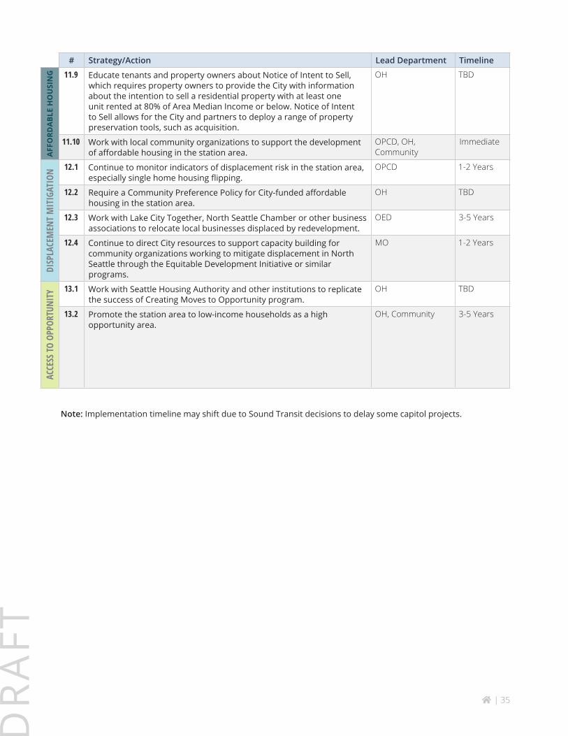
home | 35
DR
AFT
# Strategy/Action Lead Department TimelineA
FFO
RDA
BLE
HO
USI
NG 11.9 Educate tenants and property owners about Notice of Intent to Sell,
which requires property owners to provide the City with information about the intention to sell a residential property with at least one unit rented at 80% of Area Median Income or below. Notice of Intent to Sell allows for the City and partners to deploy a range of property preservation tools, such as acquisition.
OH TBD
11.10 Work with local community organizations to support the development of affordable housing in the station area.
OPCD, OH, Community
Immediate
DISP
LACE
MEN
T M
ITIG
ATIO
N 12.1 Continue to monitor indicators of displacement risk in the station area, especially single home housing flipping.
OPCD 1-2 Years
12.2 Require a Community Preference Policy for City-funded affordable housing in the station area.
OH TBD
12.3 Work with Lake City Together, North Seattle Chamber or other business associations to relocate local businesses displaced by redevelopment.
OED 3-5 Years
12.4 Continue to direct City resources to support capacity building for community organizations working to mitigate displacement in North Seattle through the Equitable Development Initiative or similar programs.
MO 1-2 Years
ACCE
SS TO
OPP
ORTU
NITY
13.1 Work with Seattle Housing Authority and other institutions to replicate the success of Creating Moves to Opportunity program.
OH TBD
13.2 Promote the station area to low-income households as a high opportunity area.
OH, Community 3-5 Years
Note: Implementation timeline may shift due to Sound Transit decisions to delay some capitol projects.

![Sabeel-e-SakinaltE 118 119 120 12'l 123 123 126 127 127 128 130 130 134 137 138 139 140 141 143 143 144 145 145,!"'-lr)]:vt!u'n"t * qlyLoJOlot *,a,Fa-ui),A* LuLq)1&iz-,ur* toJft v](https://static.fdocuments.in/doc/165x107/60a6f7ac21df6e5a8d7fa6f8/sabeel-e-sakina-lte-118-119-120-12l-123-123-126-127-127-128-130-130-134-137-138.jpg)