13) Surface Preparation and Paint Application Procedure (Splash Zone)

13. Surface Water Quality


Cross River Rail
CHAPTER 13 SURFACE WATER QUALITY
JULY 2011

CrossRiverRail
Contents 13 Surface water quality...........................................................................13-1
13.1 Introduction..................................................................................................................... 13-1 13.1.1 Methodology ................................................................................................ 13-1 13.1.2 Legislative and policy framework................................................................. 13-1
13.2 Existing environment ...................................................................................................... 13-3 13.2.1 Catchments and waterways......................................................................... 13-4 13.2.2 Surface water quality ................................................................................... 13-6
13.3 Potential impacts and mitigation................................................................................... 13-12 13.3.1 Surface water flow ..................................................................................... 13-12 13.3.2 Sedimentation and run-off ......................................................................... 13-13 13.3.3 Acid sulfate soils ........................................................................................ 13-14 13.3.4 Contaminated soil ...................................................................................... 13-14 13.3.5 Introduction of litter, toxicants and accidental spillages............................. 13-15 13.3.6 Impacts to environmental values ............................................................... 13-15 13.3.7 Construction water use .............................................................................. 13-16 13.3.8 Summary of potential impacts ................................................................... 13-16 13.3.9 Mitigation and monitoring........................................................................... 13-19
13.4 Summary ...................................................................................................................... 13-22 13.4.1 Detailed design .......................................................................................... 13-23 13.4.2 Construction............................................................................................... 13-23 13.4.3 Operation ................................................................................................... 13-23 13.4.4 Residual effects ......................................................................................... 13-23


CrossRiverRail Page 13-1
13 Surface water quality 13.1 Introduction This chapter addresses Section 3.5.2 of the Terms of Reference. A number of waterways are located within the study corridor that may be potentially affected by construction or operation of the Project through changes to surface water quality. These include major waterways such as the Brisbane River and Enoggera/Breakfast Creek, and smaller estuaries and creeks such as Oxley Creek and its tributaries. The catchment boundaries of Kedron Brook and Norman Creek are also situated within the study corridor for the Project.
This chapter assesses potential impacts of the Project on the surface water quality of these waterways. It describes the quality and health of existing waterways and assesses potential changes resulting from the construction and operation of the Project. Measures are proposed to manage possible changes in surface water quality.
Existing waterways and flood potential within the study corridor is described in Chapter 14 Flood Management, together with an assessment of the potential changes to flooding due to the Project. The potential for climate change to affect flooding is also considered in Chapter 14 Flood Management.
13.1.1 Methodology
This assessment relates to those waterways located within the study corridor as well as those that are located outside of the study corridor but may experience indirect impacts due to Project run-off into the stormwater drainage system. The assessment involved:
� a review of existing regulations, guidelines, strategies and management plans relevant to waterways potentially affected by the Project
� assessment of existing waterway conditions based on observation of waterways during site visits, water sampling and analysis, and review of available information on the existing and historical water quality, including physical, chemical and biological characteristics and environmental values and objectives
� assessment of likely impacts on surface water quality resulting from proposed construction activities and operation of the Project
� identification of measures to avoid or manage potential impacts to waterways potentially affected by the Project.
Consultation with relevant State and local government agencies was also undertaken for this assessment. The outcomes of this informed the assessment of existing waterway conditions and the identification of likely water quality impacts and mitigation measures.
13.1.2 Legislative and policy framework
This section provides a summary of the national, state and local legislative and policy framework applicable to waterways in Queensland. Further information on legislation, policies and guidelines relevant to the management of waterways in Queensland is provided in Technical Report No. 5 – Surface Water Quality.
National
Nationally, waterways are principally managed in accordance with the Australian and New Zealand Guidelines for Fresh and Marine Water Quality 2000 (ANZECC Water Quality Guidelines) and the National Water Quality Management Strategy 2000 (NWQMS). These provide guidance and strategic direction for assessing and managing water quality and for the sustainable use of water resources.

CrossRiverRail Page 13-2
The Environment Protection and Biodiversity Conservation Act 1999 (EPBC Act) also provides for the protection and management of important natural and cultural places, including the Moreton Bay Ramsar wetlands.
State
At a state level, waterways are managed through a range of legislative and policy documents. The Environmental Protection (Water) Policy 2009 (EPP (Water)) is the principal environmental policy relating to water. The EPP (Water) is subordinate legislation made under the Environmental Protection Act 1994 (EP Act). The EPP (Water) provides water quality guidelines and objectives for the protection of environmental values and provides a framework for decision making about Queensland waterways. The policy also identifies a framework for monitoring and reporting on the condition of waterways.
The Water Act 2000 (Water Act) provides for the sustainable management of water and other resources. The Water Act defines and describes watercourses and seeks to advance the sustainable management of water, including protection of the biological quality and health of natural ecosystems. One of the primary objectives of the Water Act is to maintain or improve the quality of naturally occurring waters and to protect them from degradation.
The Queensland Water Quality Guidelines 2009 (QWQG) provide water quality triggers for various regions and water types across Queensland, including South East Queensland. The guidelines define levels of aquatic ecosystem condition and describe how water quality trigger values should be applied in the protection of these environments. The QWQG also include guidelines for the management of urban stormwater.
Other legislation, guidelines and policies relevant to the management of Queensland’s surface water resources include:
� Sustainable Planning Act 2009
� Coastal Protection and Management Act 1995 (Coastal Act)
� Fisheries Act 1994
� State Coastal Management Plan 2002 (the Queensland Coastal Plan has been finalised and is proposed to come into effect in 2011, replacing the State Coastal Management Plan 2002)
� Draft Urban Stormwater - Queensland Best Practice Environmental Management Guidelines 2009
� EPA Best Practice Urban Stormwater Management - Erosion and Sediment Control Guidelines 2007
� Draft State Planning Policy for Healthy Waters 2009
� Queensland Acid Sulfate Soil Technical Manual – Legislation and Policy Guide 2004
� State Planning Policy 2/02 – Planning and Managing Development Involving Acid Sulfate Soils 2002
� Queensland Urban Drainage Manual 2007
� Draft Guidelines for the Assessment and Management of Contaminated Land in Queensland 1998.
The State Planning Policy for Healthy Waters was approved in October 2010 (SPP 4/10) and commenced on 2 May 2011. SPP 4/10 seeks to ensure development for urban purposes, including community infrastructure, is planned, designed, constructed and operated to manage stormwater and wastewater in ways to help protect the environmental values specified in the EPP (Water).

CrossRiverRail Page 13-3
The Project would be located in the area covered by the Water Resource (Moreton) Plan 2007 (WRP). The purpose of the plan is to provide a framework for sustainably managing water and identifying priorities and mechanisms for dealing with future water requirements. The plan also provides a framework for reversing, where practicable, degradation that has occurred in natural ecosystems. The WRP identifies a range of sustainable water management outcomes, environmental flow objectives and water allocation security objectives that should be achieved within the WRP area.
Regional
The South East Queensland Regional Plan 2009-2031 (SEQ Regional Plan) is the primary statutory planning strategy for South East Queensland. The plan identifies water management as a key regional policy and identifies a range of principles, policies and programs to ensure water is “managed on a sustainable and total water cycle basis to provide sufficient quantity and quality of water for human uses and to protect ecosystem health”. A key principle of the regional policy is the protection and enhancement of the ecological health, environmental values and quality of water resources, including waterways, wetlands, estuaries and Moreton Bay.
Other regional planning documents that guide the management of waterways include the South East Queensland Regional Coastal Management Plan 2006 and the South East Queensland Healthy Waterways Strategy 2007-2012. The South East Queensland Regional Coastal Management Plan 2006 will be replaced by the State Coastal Plan once it comes into effect in 2011.
Local
At a local level, waterways are managed through a range of strategies, guidelines and policies.
The Brisbane City Plan 2000 (City Plan) includes a number of planning codes which guide management of surface water. Those relevant to the Project include:
� Stormwater Management Code
� Waste Water Management (on-site effluent) Code
� Waterway Code
� Wetland Code.
The codes support the BCC’s Subdivision and Development Guidelines and Environmental Best Management Practice for Waterways and Wetlands. These outline key issues and required measures to effectively manage water quality impacts associated with development activities.
13.2 Existing environment This section describes waterways within or near to the study corridor that may be potentially affected by the construction or operation of the Project through changes to surface water quality. It includes information on waterway condition and environmental values and objectives relevant to each waterway.
Brisbane’s waterways feed directly into Moreton Bay, an important coastal resource that supports commercial fisheries, recreational fisheries and important ecological values, such as the Moreton Bay Ramsar wetlands (DEWHA 2010). The Moreton Bay ecosystem was added to the List of Wetlands of International Importance in 1993, subsequent to the Ramsar convention. It is therefore recognised as representative, rare or unique, or important for conserving biological diversity and is protected under the EPBC Act (DEWHA 2010).
CrossRiverRail Page 13-4
13.2.1 Catchments and waterways
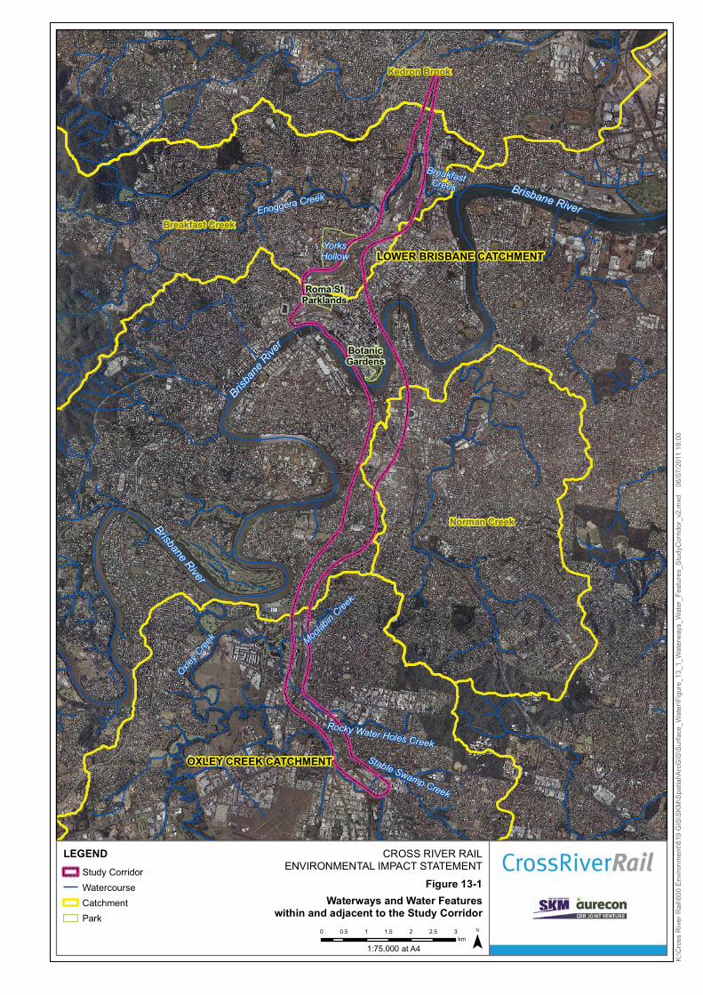
The study corridor is located within the lower Brisbane River and Oxley Creek catchments. These include a number of waterways potentially affected by the Project including:
� the Brisbane River, which generally extends the length of the study corridor and is traversed by the Project near the Brisbane CBD
� Breakfast/Enoggera Creek, which is located in the northern part of the study corridor
� Oxley Creek and its tributaries Moolabin Creek, Rocky Waterholes Creek and Stable Swamp Creek, which are located in the southern part of the study corridor.
A number of minor surface water features such as ponds and lakes are also located in the study corridor at the City Botanic Gardens, Roma Street Parklands and York’s Hollow at Victoria Park. The study corridor also traverses the catchment boundaries of Kedron Brook in the north and Norman Creek in the south. Figure 13-1 shows the waterways and water features within or near to the study corridor. Figures showing flood-prone or low lying land with or adjacent to the study corridor are provided in Chapter 14 Flood Management.
Spoil from the Project is proposed to be placed at Swanbank near Ipswich, which is located within the Bundamba Creek sub-catchment of the Bremer River (refer to Technical Report No. 5 – Surface Water Quality).
Lower Brisbane River catchment
The lower Brisbane River catchment covers an area of approximately 1,195 km2 and comprises a network of streams extending for approximately 2,475 km (EHMP 2010). The catchment is highly modified and heavily urbanised and riparian vegetation from many of the waterways in the catchment has been cleared. Large volumes of stormwater run-off enter the waterways during and after storm events.
The Brisbane River flows from the Brisbane Range through the Brisbane inner city to Moreton Bay at Pinkenba. The catchment for the Brisbane River contains approximately 850 km of river and lake banks as well as 50 major creeks (CRC 2004, DEH 1993).
Enoggera/Breakfast Creek extends approximately 39 km from the Brisbane Forest Park to the Brisbane River near Newstead (BCC 2010c; BCC 2004). The waterway’s upper freshwater reaches are known as Enoggera Creek and the lower tidal reaches are known as Breakfast Creek. Much of the creek catchment has been cleared for urban development, and land uses near to the mouth of the creek at Newstead are dominated by industrial and commercial uses. The main channel of Breakfast Creek has been straightened, widened and dredged to increase its drainage capacity, due to the creek’s history of flooding and drainage problems (BCC 2010c, BCC 2004).
Kedron Brook flows approximately 25 km from the confluence of Cedar Creek at Ferny Grove, through Brisbane’s northern suburbs to Moreton Bay at Nudgee Beach. Upstream sections of the creek are ephemeral and contain healthy natural riparian vegetation. Downstream, Kedron Brook has been channelized and contains sections of largely non-native riparian vegetation (KBCN 2010) with some sections having been diverted to allow expansion of the Brisbane Airport and for flood mitigation purposes (BCC 2010d).
Norman Creek originates as Ekibin Creek and flows to the Brisbane River at East Brisbane, through the south-eastern suburbs of Mount Gravatt, Tarragindi, Annerley, Coorparoo and Woolloongabba. The creek catchment covers an area of nearly 30 km2 and is heavily urbanised (BCC 2008).
BotanicGardens
Roma StParklands
OXLEY CREEK CATCHMENT
LOWER BRISBANE CATCHMENT
Kedron Brook
Norman Creek
Breakfast Creek
Brisbane River
Brisbane RiverEnoggera Creek
Brisba
ne R
iver
YorksHollow
Moolab
in Cree
k
Rocky Water Holes Creek
Stable Swamp Creek
BreakfastCreekOxle
y Cre
ek
CROSS RIVER RAILENVIRONMENTAL IMPACT STATEMENT
Figure 13-1Waterways and Water Features
within and adjacent to the Study Corridor
¯0 0.5 1 1.5 2 2.5 3km
LEGENDStudy CorridorWatercourseCatchmentPark
K:\C
ross
Riv
er R
ail\6
00 E
nviro
nmen
t\619
GIS
\SK
M\S
patia
l\Arc
GIS
\Sur
face
_Wat
er\F
igur
e_13
_1_W
ater
way
s_W
ater
_Fea
ture
s_S
tudy
Cor
ridor
_v2.
mxd
0
6/07
/201
1 18
:00
1:75,000 at A4

CrossRiverRail Page 13-6
Oxley Creek catchment
The Oxley Creek catchment covers an area of approximately 258 km2, south-west of Brisbane (EHMP, 2009). The catchment covers the southern part of the Project study corridor. Oxley Creek is the main waterway in the catchment. The creek extends approximately 70 km from the slopes of Mt Perry in the Scenic Rim region to the Brisbane River at Tennyson/Graceville.
The Project intercepts the Oxley Creek tributaries of Moolabin Creek, Rocky Water Holes Creek and Stable Swamp Creek at Yeerongpilly, Moorooka, Rocklea and Salisbury. These creeks have been modified from their natural state. They pass through highly urbanised areas with industrial land uses and receive urban stormwater run-off.
Other water features in the study corridor
The freshwater ornamental ponds within the City Botanic Gardens were created in the late 1950s and the lower pond was originally part of the area’s natural creek system (BCC 2010e). The freshwater lake located within the Roma Street Parkland is approximately 6,000 m2 in size and holds up to 11 million litres of water (DPW 2009). Small streams are also located within the parkland which are pumped to generate flow and maintain water quality and the lake has been stocked with native freshwater fish (DPW 2009).
York’s Hollow wetland at Victoria Park is culturally significant and was part of an original lagoon system which was remodelled as part of the Inner City Bypass construction in the early 2000s. Stormwater overflow from the York’s Hollow wetlands drains underground and eventually flows into Breakfast Creek.
Bremer catchment
The Bremer catchment is located south-west of the lower Brisbane River catchment. The catchment covers an area of approximately 2,030 km2 and comprises stream networks extending for approximately 4,425 km (EHMP 2009). Land uses in the Bremer catchment are diverse and include agriculture, mining and urban development.
The Bremer River extends approximately 82 km from the Great Dividing Range, converging with the Brisbane River at Riverview near Ipswich. The major tributaries of the Bremer River include Reynolds Creek, Warrill Creek, Western Creek, Purga Creek, Deebing Creek and Bundamba Creek.
The Bundamba Creek sub-catchment covers an area of approximately 117 km² (Telfer et al 1998). Bundamba Creek is the major tributary within the sub-catchment. Major land uses in the sub-catchment include grazing, urban residential, manufacturing, urban parks and rural residential uses, with extensive clearing of natural vegetation having occurred along the streams to allow cropping and grazing.
13.2.2 Surface water quality
This section provides an overview of existing surface water quality for waterways potentially affected by the Project.
Water quality objectives
Water quality objectives (WQO’s) are long term goals for water quality management established to support and protect the designated environmental values for various waterways. The objectives provide guideline trigger values for chemical and physical water quality indicators as well as biological indicators.
Waterways within or near to the study corridor are urban streams that receive road and stormwater run-off and support highly disturbed ecosystems. Table 13-1 outlines WQO’s relevant to the Brisbane River, Oxley Creek and its tributaries, and Bundamba Creek, respectively.

CrossRiverRail Page 13-7
Table 13-1 Water quality objectives for Brisbane River and creeks of the Brisbane River estuary, Oxley Creek and its tributaries (within Brisbane City Council local government area) and Bundamba Creek
Indicator Mid-estuary, tidal canals,
constructed estuaries
Upper estuary Lowland freshwaters
pH 7.0-8.4 7.4-8.4 6.5-8.0
Dissolved oxygen 80-105 % saturation 80-105 % saturation 85-110 % saturation
Oxidised N <10 μg/L <15 μg/L <60 μg/L
Organic N <280 μg/L <400 μg/L <420 μg/L
Ammonia N <10 μg/L <30 μg/L <20 μg/L
Total nitrogen <300 μg/L <450 μg/L <500 μg/L
Total phosphorus <25 μg/L <30 μg/L <50 μg/L
Filterable Reactive Phosphorus <6 μg/L <10 μg/L <20 μg/L
Chlorophyll a <4 μg/L <8 μg/L <5 μg/L
Turbidity (a) <8 NTU <25 NTU <50 NTU
Turbidity (b) <8 NTU <25 NTU <17 NTU
Secchi depth >1 m >0.5 m n/a
Conductivity (a) n/a n/a 600 μS/cm
Conductivity (b) n/a n/a 1120 μS/cm*
Conductivity (c) n/a n/a <770 μS/cm
Suspended solids <20 mg/L <25 mg/L <6 mg/L
Aluminium pH >6.5 ** 0.5 μg/L(1) 0.5 μg/L(1) 55 μg/L
Aluminium pH <6.5 0.5 μg/L(1) 0.5 μg/L(1) 0.8 μg/L(1)
Iron** ID ID ID
Arsenic (AsIII)** 2.3 μg/L(2) 2.3 μg/L(2) 24 μg/L
Arsenic (AsV)** 4.5 μg/L(1) 4.5 μg/L(1) 13 μg/L
Cadmium** 0.7 μg/L(B) 0.7 μg/L(B) 0.2 μg/L
Chromium (CrIII)** 27.4 μg/L 27.4 μg/L 3.3 μg/L(1)
Chromium (CrVI)** 4.4 μg/L 4.4 μg/L 1 μg/L(C)
Copper** 1.3 μg/L 1.3 μg/L 1.4 μg/L
Lead** 4.4 μg/L 4.4 μg/L 3.4 μg/L
Nickel** 7 μg/L 7 μg/L 11 μg/L
Zinc** 15 μg/L(C) 15 μg/L(C) 8 μg/L(C)
Mercury (inorganic)** 0.1 μg/L 0.1 μg/L 0.06 μg/L
Chlorine** 3 μg/L(1) 3 μg/L(1) 3 μg/L
Polycyclic Aromatic Hydrocarbons (PAH)**
Naphthalene 50 μg/L(C) 50 μg/L(C) 16 μg/L
Anthracene 0.4 μg/L(1) 0.4 μg/L(1) 0.4 μg/L(1)
Phenanthrene 2 μg/L(1) 2 μg/L(1) 2 μg/L(1)

CrossRiverRail Page 13-8
Indicator Mid-estuary, tidal canals,
constructed estuaries
Upper estuary Lowland freshwaters
Fluoranthene 1.4 μg/L(1) 1.4 μg/L(1) 1.4 μg/L(1)
Benzo(a)pyrene 0.2 μg/L(1) 0.2 μg/L(1) 0.2 μg/L(1)
BTEX**
Benzene 500 μg/L(C) 500 μg/L(C) 950 μg/L
Toluene 180 μg/L(1) 180 μg/L(1) 180 μg/L(1)
Ethylbenzene 80 μg/L(1) 80 μg/L(1) 80 μg/L(1)
Ortho-xylene ID ID 350 μg/L
Meta-xylene 75 μg/L(1) 75 μg/L(1) 75 μg/L(1)
Para-xylene ID ID 200 μg/L
Notes: Indicator values were sourced from the EPP (Water) 2009 Environmental Values and WQOs for the Brisbane River (Basin No.
143) (DERM 2010b). Indicators marked with (**) were sourced from the ANZECC Water Quality Guidelines 2000. If a particular parameter is not given in the above table, reference should be made to the EPP (Water) 2009 and the ANZECC Water Quality Guidelines 2000.
n/a = not applicable for this indicator and water type. ID = insufficient data available to derive a reliable goal value. (B) = chemicals for which bioaccumulation and secondary poisoning effects should be considered. (C) = Figure may not protect key test species from chronic toxicity (ANZECC & ARMCANZ 2000, Section 3.4, Table 4.3.1). Turbidity (a) for Brisbane River and Oxley Creek and its tributaries, Turbidity (b) for Bundamba Creek. Conductivity (a) for Brisbane River, Conductivity (b) for Oxley Creek and its tributaries, Conductivity (c) for Bundamba Creek. Indicators marked with (*) were sourced from QWQG. To comply with these WQOs, the median value of the water quality data
set should lie within the concentration range, or below the maximum concentration (DERM 2009b). (1) Low reliability trigger value for 95% protection, sourced from section 8.3.7 of the ANZECC 2000. (2) High reliability trigger value for 95% protection, sourced from section 8.3.7 of the ANZECC 2000.
Environmental values
Environmental values for waterways describe the key qualities that are important for the health of an ecosystem and for safe human waterway use. The Brisbane River, Enoggera/Breakfast Creek, Oxley Creek, Norman Creek and Bundamba Creek are located within Basin No. 143 of the broader Brisbane basin (DERM 2009b, 2009c, 2009e). Kedron Brook is located within Basin No. 142 of the broader Brisbane basin (DERM 2009d).
Table 13-2 provides a summary of the environmental values defined by the EPP (Water) for waterways potentially affected by the Project.

CrossRiverRail Page 13-9
Table 13-2 Environmental values relevant to waterways
Waterway Aqu
atic
ec
osys
tem
s
Irrig
atio
n
Hum
an
cons
umer
Stoc
k w
ater
Prim
ary
recr
eatio
n
Seco
ndar
y re
crea
tion
Visu
al
recr
eatio
n
Cul
tura
l &
spiri
tual
val
ues
Indu
stria
l use
s
Freshwater creeks and drains
� � � �
Tidal creeks/drains, estuarine
� � � �
Brisbane River
Estuarine & enclosed coastal � � � � � � �
Enoggera Creek Freshwater � � � � � �
Breakfast Creek Estuarine � � � � � �
Upper Oxley Creek
Freshwater � � � �
Lower Oxley Creek
Estuarine � � � � � �
Freshwater (urban reach) � � � � Kedron Brook
Freshwater (urban reach) � � � �
Freshwater � � � � Norman Creek
Estuarine � � � �
Freshwater � � � � � � � Bundamba Creek
Estuarine � � � �
Source: DERM 2010b, 2010c, 2010d, 2010e.
Environmental values for Enoggera/Breakfast Creek are also defined in the Breakfast/Enoggera Creek Waterway Management Plan prepared by Brisbane City Council (BCC) in consultation with relevant stakeholders. These identify additional environmental values for Enoggera Creek in relation to industrial use and irrigation (BCC 2004).
Water quality monitoring and assessment
Water quality monitoring and scientific assessment of ecosystem health in the lower Brisbane River, Oxley Creek and Bremer River catchments has been conducted by South East Queensland Healthy Waterways since 2000 as part of the Ecosystem Health Monitoring Program (EHMP). Water quality monitoring is undertaken monthly for estuarine/marine environments and twice yearly for freshwater environments, using a broad range of biological, physical and chemical indicators. Monitoring results are published in annual report cards for each of the major catchments in South East Queensland, with grades ranging from ‘A’ (excellent) to ‘F’ (fail).
Table 13-3 provides an explanation of the various report card grades.

CrossRiverRail Page 13-10
Table 13-3 EHMP report card grades
EHMP report card grade
Description
A Excellent – conditions meet all set ecosystem health values; all key processes are functional and all critical habitats are in near pristine condition.
B Good – conditions meet all set ecosystem health values in most of the reporting region; most key processes are functional and most critical habitats are intact.
C Fair – conditions meet some of the set ecosystem health values in most of the reporting region; some key processes are functional but some critical habitats are impacted.
D Poor – Conditions are unlikely to meet set ecosystem health values in most of the reporting region; many key processes are not functional and many critical habitats are impacted.
F Fail – Conditions do not meet set ecosystem health values; most key processes are not functional and most critical habitats are severely impacted.
Source: EHMP 2010
The results of water quality monitoring conducted between 2000 and 2009 are presented in Table 13-4. This monitoring found that:
� streams within the lower Brisbane River catchment in 2009 were in poor condition and generally failed to meet ecosystem health guidelines, particularly in terms of nutrient cycling, aquatic macro-invertebrates and physical/chemical indicators. Improvements in the indicators for fish and ecosystem processes were reported from previous years
� the estuarine environment of the Brisbane River recorded decreases in dissolved oxygen as well as increases in turbidity and the sewage nitrogen indicators from previous years. There was a decrease in phytoplankton abundance and results for salinity were the lowest since 2001, which was indicative of high freshwater inputs.
� streams in the Oxley Creek catchment generally failed to meet ecosystem health guidelines. The condition of the waterways was rated as poor, with these showing a significant decline in nutrient cycling throughout the year. Physical and chemical indicators improved slightly, although overall scores were lower than the previous year for four of the five ecological indicators.
� within Oxley Creek, concentrations of dissolved oxygen were low and levels of nutrients, turbidity and phytoplankton abundance had increased from previous years. These results were consistent with previous years.
� streams within the Bremer Catchment are generally in poor condition, although improved results for ecosystem processes, aquatic macroinvertebrates and fish indicators provided better grades than previous years.
Table 13-4 EHMP catchment and waterway report card grades, 2000-2009
Report card grade Waterway 2000 2001 2002 2003 2004 2005 2006 2007 2008 2009
Lower Brisbane catchment nd D- D F F D- F F F F
Brisbane River estuary D D- D- D- D- D- D- D+ D+ D
Oxley catchment nd D- D F F D- F F F F Oxley Creek (estuarine) nd nd nd nd F F F F D F
Bremer catchment nd F F D- D- D- D- D D- D+
Source: EHMP 2010 Note: nd – no data available

CrossRiverRail Page 13-11
A city-wide assessment of water quality in Brisbane’s creeks was conducted between October 1999 and March 2000 by the Department of Environment and Resource Management (DERM) and BCC (Webb 2000). Monitoring was conducted during four separate dry-weather surveys with waterway health being assessed across five scales ranging from very good to very poor. This assessment generally found that:
� freshwater quality for Enoggera/Breakfast Creek was generally good
� estuarine water quality for Enoggera/Breakfast Creek was generally poor with nutrient concentrations generally exceeding objectives and dissolved oxygen concentrations below objectives
� freshwater quality in Oxley Creek was moderate-good, although concentrations of organic nitrogen were above objectives and monitoring showed evidence of high sediment load
� water quality at estuarine monitoring sites in Oxley Creek was very poor, with concentrations of all nutrients exceeding objectives and dissolved oxygen concentrations below objectives. Water clarity was also recorded as very poor. Water quality was impacted by nutrient inputs from an upstream wastewater treatment plant, the resuspension of Brisbane River sediments from tidal exchange and upstream extractive industries.
� Moolabin Creek, Rocky Waterholes Creek and Stable Swamp Creek had moderate to very good water quality. Concentrations of ammonia and oxidised nitrogen exceeded objectives in Moolabin and Rocky Waterholes creeks, all three creeks had dissolved oxygen concentrations below objectives, while Rocky Waterholes Creek demonstrated potentially toxic pH values.
� freshwater quality in Kedron Brook and Norman Creek was generally good, while estuarine water quality was moderate in Kedron Brook and poor in Norman Creek.
Preliminary water sampling was conducted for the Project at Moolabin, Rocky Waterholes and Stable Swamp creeks, due to their proximity to construction activities. The overall biological health of these waterways is poor and water quality conditions do not meet the relevant guidelines for many water quality parameters. As such, improving the current level of aquatic health for these creeks is important.
The results of water sampling undertaken for the Project show that:
� several water quality parameters for each creek did not comply with the Queensland Water Quality Guidelines and ANZECC water quality guidelines, particularly those relating to turbidity and nutrients. This is consistent with the 2009 EHMP results for Oxley Creek
� concentrations of pH and chlorophyll-a were within the Queensland and national guidelines for each creek
� several total metal concentrations at each creek exceeded the trigger levels for toxicants, including total copper, lead and zinc. Exceedances of trigger levels were also observed for total cadmium and chromium in Rocky Waterholes and Stable Swamp Creeks
� concentrations of the aromatic hydrocarbons benzene, toluene, ethylbenzene and xylenes (BTEX) and polycyclic aromatic hydrocarbons (PAHs) were within the relevant guidelines for each creek.
Detailed results from the water sampling are presented in Technical Report No. 5 – Surface Water Quality.

CrossRiverRail Page 13-12
13.3 Potential impacts and mitigation This section provides an assessment of potential impacts on surface waterways from the construction and operation of the Project, including spoil placement at Swanbank. Measures to mitigate potential impacts on surface water quality are also identified, together with a process for on-going monitoring of impacts on surface water quality. Potential impacts on surface water quality could result from:
� changes to surface water flow
� sedimentation and surface water run-off
� disturbance of acid sulfate soils
� disturbance of contaminated land
� introduction of litter or toxicants from spills or the accidental release of pollutants.
Surface waters of concern are those in close proximity to track works, road works, worksites, excavation sites, spoil placement, tunnel portals, vegetation removal and other alterations to existing topography, notably where significant earthworks will occur at the initial stages of site establishment.
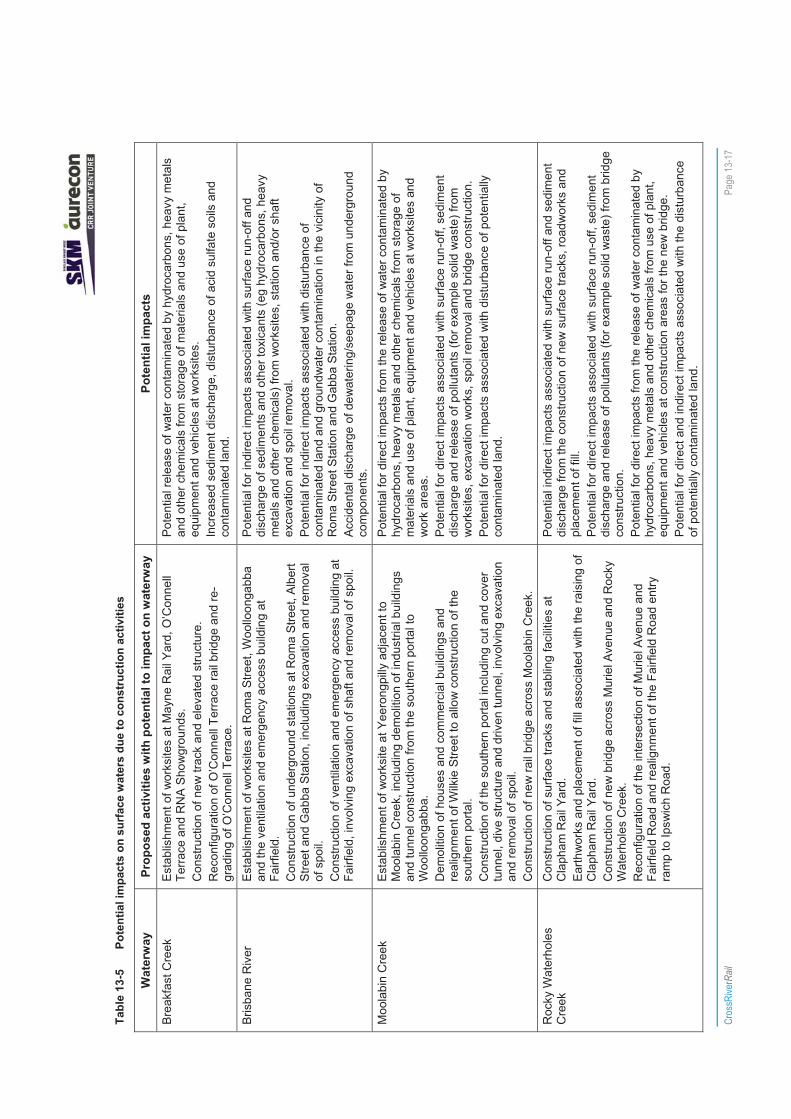
All creeks in the study corridor eventually flow into the Brisbane River, including some which are in close proximity to construction areas. These waters subsequently enter Moreton Bay, which contains marine protected zones and the internationally-recognised Ramsar Wetlands. Risks to the Brisbane River from the Project are anticipated to be primarily from indirect sources. For example, surface runoff and sediment input may be discharged from tributaries flowing into the Brisbane River.
Potential risks to Oxley Creek, tributaries of Moolabin Creek and Rocky Waterholes Creek arise from the location of a worksite adjacent to Moolabin Creek, the construction of new rail bridges and significant surface works near Yeerongpilly and Clapham Rail Yard in Moorooka. Moolabin Creek would require the construction of additional bridge piers in the floodplain for a new rail bridge, of which one pier would be located in the waterway. A new rail bridge across Rocky Waterholes Creek would also involve the construction of additional piers.
Stable Swamp Creek is also at risk of receiving sediment runoff and other pollutants from nearby construction activities, which include new track work and road realignments near Salisbury station.
On the north side of Brisbane in Bowen Hills, significant rail infrastructure alterations and road realignments involving earthworks and drainage at RNA Showgrounds and Mayne Rail Yard have the potential to impact upon Breakfast Creek. This would be managed to ensure excess sediments and other contaminants do not pollute Breakfast Creek via surface and stormwater runoff.
The potential impacts of the Project on surface waters are described in Section 13.3.1 to Section 13.3.7.
13.3.1 Surface water flow
Levee banks and stream diversions are not proposed as part of the Project. However, the Project requires new bridges to be constructed across Moolabin Creek and Rocky Waterholes Creek at Yeerongpilly and Moorooka. At Moolabin Creek, an additional twelve piers are required in the floodplain for a new rail bridge, of which one pier would be located in the waterway. Eight additional piers are also required for a new rail bridge across Rocky Waterholes Creek. Works associated with the construction of these bridges have the potential to impact on the flow of surface waters and consequently water quality. The impact of new bridge construction on surface water flows in Moolabin Creek and Rocky Waterholes Creek is described in Chapter 14 Flood Management. Permits associated with these works are described in Appendix D.

CrossRiverRail Page 13-13
Increases in water flow velocities or frequencies as a result of increased stormwater runoff from hardened areas can lead to creek erosion and subsequent decline in water quality and aquatic habitats (DNRW 2007). However, the increase in hardened areas is relatively small compared to the catchments and would be managed by means of Water Sensitive Urban Design (WSUD) measures. Measures to minimise impacts on surface water flow during construction are described in Section 13.3.9.
13.3.2 Sedimentation and run-off
During construction, suspended sediments are likely to have the greatest effect on the quality of waterways near to, or downstream from, construction activities. If not appropriately managed, construction activities could result in soil erosion and the transport of loose or excavated material into local stormwater systems and waterways. Construction activities that could result in sediment impacts on local surface waters include:
� clearing of vegetation, resulting in erosion and sediment loss
� demolition of buildings or structures
� excavation and earthworks associated with surface track works, stations and shafts, cut and cover tunnels, realignment of roads, construction of embankments and bridges, piling operations and haulage roads
� excavation, stockpiling and haulage of spoil from shaft, station and tunnel construction.
Direct impacts on waterways are possible where worksites are situated in close proximity to these features.
Construction activities at Mayne Rail Yard, O’Connell Terrace and the RNA Showground worksites may indirectly impact on Enoggera/Breakfast Creek via surface run-off and the stormwater system.
Worksites at Roma Street Station, Albert Street Station, Gabba Station and the ventilation and emergency access building at Fairfield may result in indirect impacts on the Brisbane River via surface run-off, discharge of sediments and other toxicants from worksites, station and/or shaft excavation and spoil removal.
Construction activities at Victoria Park (northern portal) also have the potential to indirectly impact on Enoggera/Breakfast Creek from surface run-off and discharge of sediments and pollutants into York’s Hollow, which flows into Breakfast Creek during overflow events.
In the south, construction works at Yeerongpilly/southern portal, Clapham Rail Yard, Moorooka, Rocklea and Salisbury have the potential for direct and indirect impacts on several waterways including Moolabin Creek, Rocky Waterholes Creek and Stable Swamp Creek.
Minor indirect impacts on Roma Street Parkland lake, City Botanic Garden ponds and Bundamba Creek may result from construction activities at Roma Street, Albert Street and placement of spoil at Swanbank respectively, from surface run-off, sediment discharge, excavation works and spoil removal.
Appropriate management and maintenance of exposed ground surfaces during construction and in the period immediately following construction would be undertaken to minimise sediment runoff following rainfall events, whilst enabling new vegetation to establish. A variety of well-established techniques would be used for managing the potential impacts of sedimentation and run-off and are summarised in Section 13.3.9. These measures would trap and filter sediments, reduce runoff velocity and potential sedimentation impacts.
Operation activities have the potential to impact surface waters through sediment accumulation and runoff from rail infrastructure during and after heavy rainfall events.
CrossRiverRail Page 13-14
Potential impacts on surface water quality associated with increased sedimentation include:
� increases in turbidity levels, which could result in reduced water clarity and light penetration, resulting in a reduction of aquatic plant growth and impacts on aquatic fauna
� changes to substrate types and blanketing of bottom substrates, possibly impacting on benthic organisms
� increases in the concentration of nutrients such as nitrogen and phosphorus, potentially resulting in increased algal growth
� reductions in the levels of dissolved oxygen, potentially impacting on aquatic fauna
� decreases to in-stream plant growth and/or increases in nuisance plant species
� changes to environmental values, particularly those relating to visual and recreational amenity.
Potential impacts on aquatic ecology resulting from increased sedimentation and run-off are described in Chapter 11 Nature Conservation.
13.3.3 Acid sulfate soils
The potential for construction activities, such as excavations, earthworks and the stockpiling and removal of spoil to disturb acid sulfate soils (ASS) is discussed in Chapter 7 Topography, Geology, Geomorphology and Soils. ASS is present in low lying areas within each section of the study corridor. There is limited potential for these soil types to be disturbed by surface works between Mayne Rail Yard and the northern portal, in the vicinity of the Albert Street Station and between the southern portal and Clapham Rail Yard.
Impacts on surface water quality can occur where run-off from worksites containing ASS disturbed by construction activities enters waterways. The reduced pH and potential mobilisation of toxicants can result in potential impacts on aquatic flora and fauna, as described in Chapter 11 Nature Conservation.
Well-established protocols exist for the identification and management of construction activities where ASS could be encountered.
Operations activities are not expected to result in disturbance to ASS. There are not expected to be any ongoing effects on surface water quality from run-off associated with ASS sites. Chapter 12 Groundwater examines the extent of groundwater drawdown associated with underground construction. The potential to lower groundwater levels in Breakfast/Enoggera Creek, Norman Creek, Oxley Creek and Brisbane River and expose potentially acidic soils is considered negligible.
13.3.4 Contaminated soil
The potential for construction activities to disturb contaminated land are examined in Chapter 8 Land Contamination. Within the study corridor, contaminated sites or potentially contaminated sites are located within Mayne Rail Yard adjacent to Breakfast/Enoggera Creek, and on land adjacent to Moolabin, Rocky Waterholes and Stable Swamp Creeks, including within the existing rail corridor and Clapham Rail Yard.
If not appropriately managed, construction activities near to surface waters could result in impacts on water quality due to contaminated sediments entering waterways via the local stormwater system or surface run-off. The release of contaminated sediment into waterways has the potential to impact on aquatic ecosystems.
During operations, disturbance of contaminated soil is not expected to occur. However, the contamination of land within the rail corridor and stabling areas as a result of train operations and maintenance activities may impact on surface waters due to contaminants entering waterways from surface run-off after periods of rainfall.

CrossRiverRail Page 13-15
13.3.5 Introduction of litter, toxicants and accidental spillages
During construction, solid waste from packaging of materials and hazardous and chemical substances such as hydrocarbons for fuel, cement slurry and other industrial chemicals are likely to be used. Contaminated water from wheel wash areas and washdown of vehicles and equipment may also be generated. Discharges could also occur via the discharge of seepage water from the underground components of the Project.
These materials and substances have the potential to be spilt, leaked, washed or blown from worksites, vehicles and equipment. Some of these pollutants may also become bound to or absorbed by sediment. If not properly managed through appropriate storage, bunding or treatment, these sources could be introduced into nearby surface waters.
Spillage or accidental release of pollutants has the potential for the greatest effect on those waterways located adjacent to worksites, such as Moolabin and Rocky Waterholes Creek in the south and Breakfast/Enoggera Creek in the north. However, other waterways may be indirectly affected by materials and substances entering waterways via the stormwater system or surface run-off.
The release of toxicants and litter into waterways has the potential to impact on surface water quality and consequently on aquatic ecosystems. This also has the potential to impact on identified environmental values through the reduction of visual and recreational amenity.
During operations, the main risk to surface water from the release of pollutants is from spills or the release of litter and toxicants such as heavy metals, petroleum hydrocarbons and PAHs from vehicles, surface run-off from tracks, stabling areas, stations and paved surfaces, and maintenance of rail vehicles.
13.3.6 Impacts to environmental values
Environmental values describe those qualities that are important for the health of ecosystems and for safe human waterway use (refer to Section 13.2.2). Potential impacts of the Project’s construction and operation on the environmental values of waterways within or near the study corridor could include:
� reduced aquatic ecosystem health
� decreased visual and recreational amenity
� changes to cultural and spiritual values of waterways
� compromising human health
� reduced suitability of surface waters for irrigation and stock watering.
If not appropriately managed, any impact to the existing quality of surface waters may threaten the environmental values listed above. Accordingly, the construction and operation of the Project would be managed to ensure that the current condition of surface waters within the study corridor is maintained and not significantly impacted. As described in the EPP (Water), surface waters should not be polluted with materials that may settle to obstruct waterways from floating debris and visible oil/scum slicks, produce an unpleasant colour/odour or cause adverse impacts to aquatic life. Indigenous and Non-Indigenous cultural heritage should be protected or restored.
Rehabilitation plans would be designed to ensure relevant environmental values are addressed. Surface water monitoring programs would be conducted to audit, monitor and manage potential impacts to environmental values (refer to Section 13.3.9).

CrossRiverRail Page 13-16
13.3.7 Construction water use
Impacts on surface water quality could also result from the use of water, including recycled water, for environmental management purposes and construction activities.
The construction phase of the Project would require water to be used for a range of construction activities. Recycled water could be used for dust suppression, earth compaction, washdown of vehicles and equipment and production of grout and shotcrete.
The reuse of water on-site for construction activities, including wastewater from on-site treatment plants, dewatering activities and rainwater captured on-site has potential benefits of reducing the demand on potable water supply.
However, a risk would remain that untreated wastewater could be accidentally released, potentially impacting the surrounding environment and affecting human health eg potential for gastroenteritis. Adverse impacts may occur from sudden and significant changes in water quality parameters such as salinity, pH and turbidity, or from the addition of foreign substances, such as hydrocarbons and sewage.
The use of wastewater would be regulated through the approval process, with specific measures to identify and avoid risks of off-site impacts. These are detailed in the environmental management plan, the draft outlines of which are presented in Chapter 24 Draft Outline EMP and include procedures for emergency response and spill containment.
13.3.8 Summary of potential impacts
Table 13-5 provides a summary of potential impacts on waterways in or near to the study corridor from key construction activities.
Cros
sRive
rRail
Pa
ge 13
-17
Tabl
e 13
-5
Pote
ntia
l im
pact
s on
sur
face
wat
ers
due
to c
onst
ruct
ion
activ
ities
Wat
erw
ay
Prop
osed
act
iviti
es w
ith p
oten
tial t
o im
pact
on
wat
erw
ay
Pote
ntia
l im
pact
s
Bre
akfa
st C
reek
E
stab
lishm
ent o
f wor
ksite
s at
May
ne R
ail Y
ard,
O’C
onne
ll Te
rrace
and
RN
A S
how
grou
nds.
C
onst
ruct
ion
of n
ew tr
ack
and
elev
ated
stru
ctur
e.
Rec
onfig
urat
ion
of O
’Con
nell
Terra
ce ra
il br
idge
and
re-
grad
ing
of O
’Con
nell
Terra
ce.
Pote
ntia
l rel
ease
of w
ater
con
tam
inat
ed b
y hy
droc
arbo
ns, h
eavy
met
als
and
othe
r che
mic
als
from
sto
rage
of m
ater
ials
and
use
of p
lant
, eq
uipm
ent a
nd v
ehic
les
at w
orks
ites.
In
crea
sed
sedi
men
t dis
char
ge, d
istu
rban
ce o
f aci
d su
lfate
soi
ls a
nd
cont
amin
ated
land
.
Bris
bane
Riv
er
Est
ablis
hmen
t of w
orks
ites
at R
oma
Stre
et, W
oollo
onga
bba
and
the
vent
ilatio
n an
d em
erge
ncy
acce
ss b
uild
ing
at
Fairf
ield
. C
onst
ruct
ion
of u
nder
grou
nd s
tatio
ns a
t Rom
a S
treet
, Alb
ert
Stre
et a
nd G
abba
Sta
tion,
incl
udin
g ex
cava
tion
and
rem
oval
of
spo
il.
Con
stru
ctio
n of
ven
tilat
ion
and
emer
genc
y ac
cess
bui
ldin
g at
Fa
irfie
ld, i
nvol
ving
exc
avat
ion
of s
haft
and
rem
oval
of s
poil.
Pot
entia
l for
indi
rect
impa
cts
asso
ciat
ed w
ith s
urfa
ce ru
n-of
f and
di
scha
rge
of s
edim
ents
and
oth
er to
xica
nts
(eg
hydr
ocar
bons
, hea
vy
met
als
and
othe
r che
mic
als)
from
wor
ksite
s, s
tatio
n an
d/or
sha
ft ex
cava
tion
and
spoi
l rem
oval
. P
oten
tial f
or in
dire
ct im
pact
s as
soci
ated
with
dis
turb
ance
of
cont
amin
ated
land
and
gro
undw
ater
con
tam
inat
ion
in th
e vi
cini
ty o
f R
oma
Stre
et S
tatio
n an
d G
abba
Sta
tion.
A
ccid
enta
l dis
char
ge o
f dew
ater
ing/
seep
age
wat
er fr
om u
nder
grou
nd
com
pone
nts.
M
oola
bin
Cre
ek
Est
ablis
hmen
t of w
orks
ite a
t Yee
rong
pilly
adj
acen
t to
Moo
labi
n C
reek
, inc
ludi
ng d
emol
ition
of i
ndus
trial
bui
ldin
gs
and
tunn
el c
onst
ruct
ion
from
the
sout
hern
por
tal t
o W
oollo
onga
bba.
D
emol
ition
of h
ouse
s an
d co
mm
erci
al b
uild
ings
and
re
alig
nmen
t of W
ilkie
Stre
et to
allo
w c
onst
ruct
ion
of th
e so
uthe
rn p
orta
l. C
onst
ruct
ion
of th
e so
uthe
rn p
orta
l inc
ludi
ng c
ut a
nd c
over
tu
nnel
, div
e st
ruct
ure
and
driv
en tu
nnel
, inv
olvi
ng e
xcav
atio
n an
d re
mov
al o
f spo
il.
Con
stru
ctio
n of
new
rail
brid
ge a
cros
s M
oola
bin
Cre
ek.
Pot
entia
l for
dire
ct im
pact
s fro
m th
e re
leas
e of
wat
er c
onta
min
ated
by
hydr
ocar
bons
, hea
vy m
etal
s an
d ot
her c
hem
ical
s fro
m s
tora
ge o
f m
ater
ials
and
use
of p
lant
, equ
ipm
ent a
nd v
ehic
les
at w
orks
ites
and
wor
k ar
eas.
P
oten
tial f
or d
irect
impa
cts
asso
ciat
ed w
ith s
urfa
ce ru
n-of
f, se
dim
ent
disc
harg
e an
d re
leas
e of
pol
luta
nts
(for e
xam
ple
solid
was
te) f
rom
w
orks
ites,
exc
avat
ion
wor
ks, s
poil
rem
oval
and
brid
ge c
onst
ruct
ion.
P
oten
tial f
or d
irect
impa
cts
asso
ciat
ed w
ith d
istu
rban
ce o
f pot
entia
lly
cont
amin
ated
land
.
Roc
ky W
ater
hole
s C
reek
C
onst
ruct
ion
of s
urfa
ce tr
acks
and
sta
blin
g fa
cilit
ies
at
Cla
pham
Rai
l Yar
d.
Ear
thw
orks
and
pla
cem
ent o
f fill
asso
ciat
ed w
ith th
e ra
isin
g of
C
laph
am R
ail Y
ard.
C
onst
ruct
ion
of n
ew b
ridge
acr
oss
Mur
iel A
venu
e an
d R
ocky
W
ater
hole
s C
reek
. R
econ
figur
atio
n of
the
inte
rsec
tion
of M
urie
l Ave
nue
and
Fairf
ield
Roa
d an
d re
alig
nmen
t of t
he F
airfi
eld
Roa
d en
try
ram
p to
Ipsw
ich
Roa
d.
Pot
entia
l ind
irect
impa
cts
asso
ciat
ed w
ith s
urfa
ce ru
n-of
f and
sed
imen
t di
scha
rge
from
the
cons
truct
ion
of n
ew s
urfa
ce tr
acks
, roa
dwor
ks a
nd
plac
emen
t of f
ill.
Pot
entia
l for
dire
ct im
pact
s as
soci
ated
with
sur
face
run-
off,
sedi
men
t di
scha
rge
and
rele
ase
of p
ollu
tant
s (fo
r exa
mpl
e so
lid w
aste
) fro
m b
ridge
co
nstru
ctio
n.
Pot
entia
l for
dire
ct im
pact
s fro
m th
e re
leas
e of
wat
er c
onta
min
ated
by
hydr
ocar
bons
, hea
vy m
etal
s an
d ot
her c
hem
ical
s fro
m u
se o
f pla
nt,
equi
pmen
t and
veh
icle
s at
con
stru
ctio
n ar
eas
for t
he n
ew b
ridge
. P
oten
tial f
or d
irect
and
indi
rect
impa
cts
asso
ciat
ed w
ith th
e di
stur
banc
e of
pot
entia
lly c
onta
min
ated
land
.

Cros
sRive
rRail
Page
13-1
8
Wat
erw
ay
Prop
osed
act
iviti
es w
ith p
oten
tial t
o im
pact
on
wat
erw
ay
Pote
ntia
l im
pact
s
Stab
le S
wam
p C
reek
C
onst
ruct
ion
of n
ew s
urfa
ce tr
acks
with
in o
r adj
acen
t to
the
exis
ting
rail
corr
idor
. D
emol
ition
of i
ndus
trial
bui
ldin
gs a
djac
ent t
o th
e ra
il co
rrido
r. R
ealig
nmen
t of l
ocal
road
s (fo
r exa
mpl
e D
ollis
Stre
et).
Pot
entia
l ind
irect
impa
cts
asso
ciat
ed w
ith s
urfa
ce ru
n-of
f, se
dim
ent
disc
harg
e an
d re
leas
e of
oth
er to
xica
nts
from
the
cons
truct
ion
of n
ew
surfa
ce tr
acks
and
road
wor
ks.
Pot
entia
l for
indi
rect
impa
cts
asso
ciat
ed w
ith th
e di
stur
banc
e of
po
tent
ially
con
tam
inat
ed la
nd.
Yor
k’s
Hol
low
E
stab
lishm
ent o
f wor
ksite
at V
icto
ria P
ark,
invo
lvin
g de
mol
ition
of b
uild
ings
, exc
avat
ion
of c
uttin
gs a
nd c
lear
ing
of
vege
tatio
n.
Con
stru
ctio
n of
nor
ther
n po
rtal,
incl
udin
g cu
t and
cov
er tu
nnel
, di
ve s
truct
ure
and
driv
en tu
nnel
, inv
olvi
ng e
xcav
atio
n an
d re
mov
al o
f spo
il.
Min
or p
oten
tial f
or in
dire
ct im
pact
s as
soci
ated
with
sur
face
run-
off a
nd
sedi
men
t dis
char
ge fr
om w
orks
ite, e
xcav
atio
n w
orks
and
spo
il re
mov
al.
Rom
a S
treet
Par
klan
d la
ke
Dem
oliti
on o
f bui
ldin
gs a
nd s
truct
ures
for w
orks
ite
esta
blis
hmen
t. C
onst
ruct
ion
of R
oma
Stre
et u
nder
grou
nd s
tatio
n, in
clud
ing
exca
vatio
n an
d re
mov
al o
f spo
il fro
m s
hafts
.
Ver
y m
inor
pot
entia
l for
indi
rect
impa
cts
asso
ciat
ed w
ith s
urfa
ce ru
n-of
f an
d se
dim
ent d
isch
arge
from
sha
ft ex
cava
tion
and
spoi
l rem
oval
. A
ccid
enta
l dis
char
ge o
f dew
ater
ing/
seep
age
wat
er fr
om u
nder
grou
nd
com
pone
nts.
C
ity B
otan
ic G
arde
n po
nds
Est
ablis
hmen
t of w
orks
ites
at c
orne
r of A
lber
t Stre
et a
nd A
lice
Stre
et, a
nd A
lber
t Stre
et a
nd M
ary
Stre
et, i
nvol
ving
the
dem
oliti
on o
f bui
ldin
gs a
nd s
truct
ures
. C
onst
ruct
ion
of lo
wer
Alb
ert S
treet
und
ergr
ound
sta
tion,
in
clud
ing
exca
vatio
n of
sha
fts a
nd s
tatio
n ca
vern
and
rem
oval
of
spo
il.
Con
stru
ctio
n of
sub
way
and
ent
ranc
e un
der A
lice
Stre
et.
Ver
y m
inor
pot
entia
l for
indi
rect
impa
cts
asso
ciat
ed w
ith s
urfa
ce ru
n-of
f an
d se
dim
ent d
isch
arge
from
wor
ksite
s, e
xcav
atio
n w
orks
and
spo
il re
mov
al a
nd th
e re
leas
e of
wat
er c
onta
min
ated
by
hydr
ocar
bons
, hea
vy
met
als
and
othe
r che
mic
als
from
sto
rage
of m
ater
ials
and
use
of p
lant
, eq
uipm
ent a
nd v
ehic
les
at w
orks
ites.
A
ccid
enta
l dis
char
ge o
f dew
ater
ing/
seep
age
wat
er fr
om u
nder
grou
nd
com
pone
nts.
Bun
dam
ba C
reek
P
lace
men
t of s
poil
at S
wan
bank
. M
inor
pot
entia
l for
indi
rect
impa
cts
asso
ciat
ed w
ith s
urfa
ce ru
n-of
f and
se
dim
ent d
isch
arge
from
spo
il pl
acem
ent.
CrossRiverRail Page 13-19
13.3.9 Mitigation and monitoring
This section outlines measures for managing potential impacts on surface waters near to the Project works along with a program for on-going water quality monitoring. The controls provide a range of measures which have been regularly and successfully applied to similar large scale construction projects.
Construction
The construction phase of the Project constitutes the major risk to surface water quality and therefore it is vital that appropriate mitigation and monitoring measures are implemented. A soil, erosion and sediment control management sub-plan would be prepared and implemented as part of the draft outline EMP to avoid or minimise the transfer of sediment or other pollutants from construction activities to waterways or stormwater systems (refer to Chapter 24 Draft Outline EMP).
During construction, potential impacts on surface water quality would be managed through the following measures and controls:
� minimising the area of vegetation clearing and changes to topography and landform and progressively rehabilitating and restoring cleared sections where appropriate, particularly where new waterway crossings are constructed or where creek banks are impacted eg Moolabin Creek, Rocky Waterholes Creek and Stable Swamp Creek
� installing effective erosion, sediment, dust and stormwater controls, eg containment bunds, silt traps, sediment basins and fences, turbidity barriers and diversions, dust suppression and earth compaction, at worksites, washdown areas and spoil placement sites prior to construction works commencing
� stockpiling materials and spoil away from natural drainage areas
� placing spoil at spoil placement sites away from known flood affected areas, existing drainage lines and waterways
� diverting stormwater from higher ground around disturbed areas, where possible
� implementing WSUD measures at worksites eg swales, bio-retention systems and vegetation buffers, to divert or treat contaminated waters and stormwater prior to run-off into receiving surface waters
� ensuring dust suppression measures and vehicle washdown prior to exiting worksites
� implementing appropriate practices and procedures for the handling, storing and management of chemicals and hydrocarbons, including for the effective management and clean-up of spills or other emergencies
� locating chemical storage areas and washdown facilities away from existing drainage lines and waterways and implementing appropriate bunding and wastewater collection mechanisms
� ensuring chemical and hydrocarbon wastewater is disposed to a liquid waste disposal facility or company, or treated via an approved on-site system to an acceptable level for discharge with the permission of the responsible authority. Temporary water treatment facilities eg for stormwater, hydrocarbon wastewater, would be provided at the Yeerongpilly, Boggo Road and Woollongabba worksites
� implementing practices and procedures for the handling, storing and management of recycled water (for example for dust suppression, earth compaction, washdown of vehicles/equipment, production of grout and shotcrete)
� undertake washing, degreasing, servicing, cleaning and maintenance of vehicles, plant or other equipment away from areas where resulting contaminants may be released to any stormwater drain, land or waters

CrossRiverRail Page 13-20
� ensuring that worksite rehabilitation plans are designed to address relevant environmental values listed in Section 13.2
� designing bridges and embankments to minimise impacts on water quality (for example placement of viaduct pilings across Moolabin Creek and bridge construction above Rocky Waterholes Creek).
Proposed measures for managing the potential impacts of ASS or contaminated soils are described in Chapter 7 Topography, Geology, Geomorphology and Soils and Chapter 8 Land Contamination respectively. Mitigation for ASS in the study corridor would implement best monitoring and management practices. Additional measures for ASS would involve protecting nearby surface waters from polluted runoff eg Breakfast Creek and adjacent to Moolabin Creek. Appropriate erosion and sediment controls and staging of worksite activities would be adopted to minimise the extent of disturbed areas and the potential run-off of contaminated soils.
Daily monitoring and maintenance of erosion, sediment, dust and stormwater control measures would ensure their continued effectiveness for the duration of construction activities.
Operation
During operation, a number of measures would be used to effectively manage and treat run-off from surface tracks, maintenance facilities and stations. These measures would seek to reduce the volume of run-off and pollutant load.
WSUD measures applied to the operation phase would mitigate cumulative impacts, by reducing runoff volumes and stormwater pollution via natural systems for infiltration, evapotranspiration and the reuse of urban stormwater. A number of different components and controls would be investigated and developed during the detailed design phase for inclusion in the final design. These include:
� grassed/vegetated swales
� permanent settlement ponds and detention basins
� use of stormwater quality improvement devices (for example gross pollutant traps, gully pit baskets and nets) to filter stormwater and prevent pollution of surface waters
� oil/grit separators to remove hydrocarbons and coarse sediments.
Permanent water quality treatment control devices would be designed for the adequate control of pollution and sediment and other coarse materials during flood events.
Groundwater in the vicinity of Roma Street Station and Gabba Station may have some contamination that would require the ingress of water collected from the tunnels and stations in these locations to require a degree of water treatment. The precise contaminants and their concentrations in the groundwater are not known at this stage and consequently the water treatment plant cannot be accurately specified. However, an allowance has been made for two water treatment plants, one at each of the two station locations. The outfalls from the water treatment plants would be discharged to the stormwater drainage system, if required. All discharge pipes would be appropriately sized at detailed design stage to accommodate the volume of discharge water.
The need for treatment plants at other underground stations for groundwater inflows will be considered during detailed design.
A risk management approach would be adopted for the reuse of any water captured on site, including effluent from any onsite sewage treatment facilities and rain water captured within tanks, in accordance with the Australian Guidelines for Water Recycling (EPHC et al 2008). These guidelines provide a consistent approach to the assessment and use of recycled water across Australia.

CrossRiverRail Page 13-21
Controlled discharges would be treated before release to receiving surface waters, in accordance with the ANZECC and ARMCANZ WQO’s for surface waters (as outlined in Section 13.2.2) and the Australian Guidelines for Water Recycling (EPHC et al, 2008). Any uncontrolled discharges of water would be avoided and, if they occur, stopped as soon as possible. For wastewater discharge to aquatic ecosystems that are recognised as ‘slightly to moderately disturbed’, as per the EPP (Water) Operational Policy for Waste Water Discharge to Queensland Waters and in accordance with the EP Act, management actions would:
� maintain the current water quality where existing water quality is better than the scheduled WQOs
� maintain water quality where existing water quality corresponds to the scheduled WQOs
� improve water quality and prevent further degradation where existing water quality is of a lower quality than the scheduled WQOs. Attainment of the scheduled WQOs would be sought through continual improvement over time and may be a long-term goal.
Stormwater treatment techniques would follow the NWQMS management hierarchy (ANZECC & ARMCANZ 2000) for protecting water quality, as follows:
a) retain, restore or rehabilitate valuable ecosystems
b) source control through non-structural measures (for example pollution prevention)
c) source control through structural measures (for example screening solids/litter/debris, isolating hydrocarbons, chemicals and other toxicants through physical entrapment, separating layers of substances such as sediments and oil, filtration, adsorption, flocculation, infiltration, oxidation)
d) use regional in-stream treatment measures.
Following construction, an operations EMP would be developed to avoid potential water quality impacts (refer to Chapter 24 Draft Outline EMP).
Water quality monitoring
A water quality monitoring program would be established prior to construction to ensure compliance with identified WQO’s and to enable potential impacts to surface water quality to be identified, controlled and reported. This would include targeted baseline monitoring of receiving waters prior to construction to identify baseline water quality conditions. Monitoring, auditing and reporting strategies are provided in Chapter 24 Draft Outline EMP.
The monitoring program would be included in the construction EMP (refer to Chapter 24 Draft Outline EMP). This would involve the collection and analysis of surface water samples at selected locations in the study corridor where worksites are in close proximity to waterways. This would include Stable Swamp Creek and Rocky Waterholes Creek near Clapham Rail Yard, Moolabin Creek adjacent to Yeerongpilly worksite and Breakfast Creek near Mayne Rail Yard.
In-situ parameters that would be measured include pH, conductivity, dissolved oxygen and turbidity. A visual inspection would also be undertaken of each monitoring site for the presence of oil or grease films on the water surface. Samples collected for laboratory analyses would measure indicators such as nutrients, suspended sediments, hydrocarbons and trace metals (to be determined by the approval conditions for discharge criteria). Non-conformances would be reported to the on-site environmental officer for immediate corrective action.
Monitoring would also include regular visual inspection of drainage channels and surface waters near to worksites, particularly after periods of rainfall to monitor sediment run-off, erosion, waste (eg litter and oil), debris and ponding (potential mosquito breeding habitat).
A monitoring program during operation would assess and manage potential long-term and cumulative impacts of the Project on surface waters.
CrossRiverRail Page 13-22
The following guidelines have been used to establish construction and operation monitoring programs for the Project, as outlined in Chapter 24 Draft Outline EMP:
� Australian and New Zealand Guidelines for Fresh and Marine Water Quality, 2000
� Queensland Water Quality Guidelines, 2009
� National Water Quality Management Strategy, 2000.
Water quality would be compared with the relevant WQO’s. If concentrations exceed the trigger values, then additional investigation and mitigation measures would be implemented.
13.4 Summary A number of waterways are located within the study corridor that may be potentially affected by construction or operation of the Project, through changes to surface water quality. These include major waterways such as the Brisbane River and Enoggera/Breakfast Creek, and smaller estuaries and creeks such as Oxley Creek and its tributaries. The catchment boundaries of Kedron Brook and Norman Creek are also situated within the study corridor for the Project. A number of surface water features such as ponds and lakes are also located in the study corridor at the City Botanic Gardens, Roma Street Parklands and York’s Hollow at Victoria Park.
The assessment of existing water quality for those waterways potentially affected by the Project has concluded that they are in poor condition and generally fail to meet ecosystem health guidelines.
Potential impacts on surface water quality from the Project could result from:
� use of water, including recycled water, for environmental management purposes and construction activities
� sedimentation and surface water run-off
� disturbance of acid sulfate soils
� disturbance of contaminated land
� introduction of litter or toxicants from spills or the accidental release of pollutants.
A range of measures would be implemented during the construction phase to avoid or minimise the transfer of sediment or other pollutants to waterways and drainage lines. These include:
� minimising vegetation clearing and progressive rehabilitation and restoration of cleared areas, particularly at new waterway crossings
� the installation of effective erosion, sediment, dust and stormwater controls
� avoiding flood affected areas, drainage lines and waterways in the stockpiling and placement of spoil and other materials
� implementing WSUD measures at worksites
� implementing appropriate practices and procedures for the handling, storing and management of chemicals and hydrocarbons.
On-going water quality monitoring during operation would ensure compliance with identified WQO’s and enable potential impacts on surface water quality to be identified, controlled and reported. Further details of these management measures are provided in Chapter 24 Draft Outline EMP.

CrossRiverRail Page 13-23
13.4.1 Detailed design
A variety of measures would be investigated and developed during the detailed design phase to protect surface water quality. In particular, the incorporation of WSUD measures into the detailed design would seek to minimise impacts on the urban water cycle.
13.4.2 Construction
The construction phase of the Project constitutes a potential risk to surface water quality as water discharged from construction areas and worksites has the potential to impact on nearby waterways if not appropriately managed. The protection of waterways and surface water features would be specifically addressed within the draft outline EMP. The EMP would provide a range of measures and controls to avoid or minimise the transfer of sediment or other pollutants from construction activities to waterways or stormwater systems.
Water quality monitoring during construction would enable potential impacts on surface water quality to be identified, controlled and reported. By following these practices, any risks would be minimised to a level where potential events would be contained and limited in scale.
13.4.3 Operation
The adoption of WSUD measures at the detailed design phase and other water treatment features would effectively manage and treat run-off from surface tracks, maintenance facilities and stations. As the existing water quality for those waterways potentially affected by the Project is generally poor, the proposed mitigation measures may result in an improvement to existing run-off quality.
13.4.4 Residual effects
The limited residual effects described as follows are those effects potentially remaining after mitigation measures have been implemented.
Construction
With the implementation of the proposed mitigation measures described in Section 13.3.9, residual effects on surface water quality during construction are predicted to be low over the short-term.
Operation
Following the implementation of water treatment measures for the operations phase, residual effects on receiving waterways are predicted to be low over the long-term. A water quality monitoring program would be implemented during operation to assess, mitigate and manage any residual effects on surface waters.