12. Tropical Cyclone Diurnal Cycle Experiment Principal ... · Tropical Cyclone Diurnal Cycle...
7
12. Tropical Cyclone Diurnal Cycle Experiment Principal Investigator: Jason Dunion (HRD) Links to IFEX goals: • Goal 1: Collect observations that span the TC lifecycle in a variety of environments; • Goal 3: Improve understanding of the physical processes important in intensity change for a TC at all stages of its lifecycle; Program Significance: Numerous studies have documented the existence of diurnal maxima and minima associated with tropical convection. However, predicting the timing and extent of this variability remains a difficult challenge. Recent research using GOES satellite imagery has identified a robust signal of tropical cyclone diurnal pulsing. These pulses can be tracked using new GOES infrared satellite image differencing that reveals a “cool ring” (i.e. diurnal pulse) in the infrared that begins forming in the storm’s inner core near local sunset each day. This diurnal pulse continues to propagate away from the storm overnight, reaching areas several hundred km from the storm center by the following afternoon. There appear to be significant structural changes to TCs [as indicated by GOES IR and microwave (37 and 85 GHz) satellite imagery] as diurnal pulses move out from the inner core each day and their timing/propagation also appears to be remarkably predictable. Although the relationships between the TC diurnal cycle and TC structure and intensity are unclear at this time, this phenomenon may be an important and fundamental TC process. Objectives: • The main goal of this experiment is to sample the thermodynamic and kinematic environment of diurnal pulses at various stages of their life cycles, including their initial formation and subsequent evolution, and to observe any corresponding fluctuations in TC structure and intensity during these events; • Employ both NOAA P-3 and G-IV aircraft to collect kinematic and thermodynamic observations both within the inner-core (i.e., radius <~150 km) and in the surrounding large-scale environment (i.e., R=~150-400+ km) for systems that have exhibited signs of diurnal pulsing in the previous 24 hours; • Employ the NOAA G-IV jet to sample the temperature, moisture, and winds at the TC cirrus canopy level before, during, and after the time of local sunset; • Quantify the capabilities of the operational coupled model forecast system to accurately capture thermodynamic (e.g. cirrus canopy cooling at sunset) and kinematic (e.g. enhanced upper-level outflow) characteristics of the TC diurnal cycle and associated diurnal pulses; Hypotheses: • Although the exact nature of diurnal pulses is not yet clear, new GOES IR satellite imagery and recent model simulations indicate a diurnal process that may be driven by rapid changes in incoming shortwave radiation resulting in rapid cooling at the cirrus canopy level around sunset each day; • Data from Caribbean rawinsondes and NASA HS3 Global Hawk GPS dropsondes suggests that there are two necessary conditions needed to initiate TC diurnal pulses: an established cirrus canopy over an area of deep convection and rapid cooling of the cloud tops (i.e. sunset cooling).
Transcript of 12. Tropical Cyclone Diurnal Cycle Experiment Principal ... · Tropical Cyclone Diurnal Cycle...
12. Tropical Cyclone Diurnal Cycle Experiment
Principal Investigator: Jason Dunion (HRD)
Links to IFEX goals:
• Goal 1: Collect observations that span the TC lifecycle in a variety of environments; • Goal 3: Improve understanding of the physical processes important in intensity change for a TC at
all stages of its lifecycle; Program Significance:
Numerous studies have documented the existence of diurnal maxima and minima associated with tropical convection. However, predicting the timing and extent of this variability remains a difficult challenge. Recent research using GOES satellite imagery has identified a robust signal of tropical cyclone diurnal pulsing. These pulses can be tracked using new GOES infrared satellite image differencing that reveals a “cool ring” (i.e. diurnal pulse) in the infrared that begins forming in the storm’s inner core near local sunset each day. This diurnal pulse continues to propagate away from the storm overnight, reaching areas several hundred km from the storm center by the following afternoon. There appear to be significant structural changes to TCs [as indicated by GOES IR and microwave (37 and 85 GHz) satellite imagery] as diurnal pulses move out from the inner core each day and their timing/propagation also appears to be remarkably predictable. Although the relationships between the TC diurnal cycle and TC structure and intensity are unclear at this time, this phenomenon may be an important and fundamental TC process.
Objectives:
• The main goal of this experiment is to sample the thermodynamic and kinematic environment of diurnal pulses at various stages of their life cycles, including their initial formation and subsequent evolution, and to observe any corresponding fluctuations in TC structure and intensity during these events;
• Employ both NOAA P-3 and G-IV aircraft to collect kinematic and thermodynamic observations both within the inner-core (i.e., radius <~150 km) and in the surrounding large-scale environment (i.e., R=~150-400+ km) for systems that have exhibited signs of diurnal pulsing in the previous 24 hours;
• Employ the NOAA G-IV jet to sample the temperature, moisture, and winds at the TC cirrus canopy level before, during, and after the time of local sunset;
• Quantify the capabilities of the operational coupled model forecast system to accurately capture thermodynamic (e.g. cirrus canopy cooling at sunset) and kinematic (e.g. enhanced upper-level outflow) characteristics of the TC diurnal cycle and associated diurnal pulses;
Hypotheses:
• Although the exact nature of diurnal pulses is not yet clear, new GOES IR satellite imagery and recent model simulations indicate a diurnal process that may be driven by rapid changes in incoming shortwave radiation resulting in rapid cooling at the cirrus canopy level around sunset each day;
• Data from Caribbean rawinsondes and NASA HS3 Global Hawk GPS dropsondes suggests that there are two necessary conditions needed to initiate TC diurnal pulses: an established cirrus canopy over an area of deep convection and rapid cooling of the cloud tops (i.e. sunset cooling).
These conditions appear create large (~2-5 C) temperature inversions near the cirrus canopy top that may be linked diurnal pulse formation;
• Diurnal pulses may be signatures of outwardly propagating gravity waves, harmonic oscillations of the CDO as it cools near the time of sunset, diurnally-driven changes in inertial stability in the upper-levels (i.e. cirrus canopy) of the storm, or temperature responses that lead to previously documented anvil expansion.
• Diurnal pulses may be associated with periods of enhanced upper-level outflow (as seen in GOES IR imagery) and may extend through a relatively deep layer of the low- to mid-level troposphere (suggested by 37/85 GHz microwave imagery and data from the P-3 lower fuselage radar);
• Observations of the TC diurnal cycle can be used to improve our understanding of this recently discovered phenomenon and test its observability in model simulations;
Model Evaluation Component: The TC diurnal cycle may be a fundamental TC process that initiates the formation of TC diurnal pulses near the time of local sunset each day. These TC diurnal pulses radially propagate from the TC inner core and reach peripheral radii (e.g. 300-400 km) the following morning and afternoon. Although the cirrus canopy is typically an under-sampled region of the storm, changes in the thermodynamic structure and outflow patterns in this region of the storm near the time of sunset will be sampled and may be a key component to the formation and evolution of TC diurnal pulses. The predictable propagation of TC diurnal pulses in both space and time each day makes them fairly easy to sample at various radii around the storm. Thermodynamic and kinematic observations will be made of the diurnal pulses from the surface to the cirrus canopy and will include outflow layer sampling, as well as areas of enhanced convergence, moisture, or vertical motions at various levels of the troposphere. Thermodynamic and kinematic observations that are collected during this module will be used to evaluate the robustness of the operational coupled model forecast system to represent the TC diurnal cycle.
Mission Description:
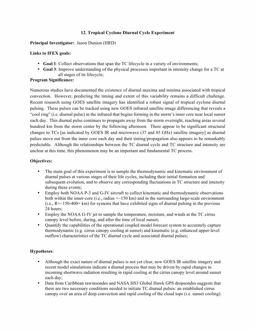
The experimental UW-CIMSS/HRD TC diurnal cycle web page (http://tropic.ssec.wisc.edu/real-time/tc_diurnal_cycle/tc_diurnal_cycle.php) will be used to monitor the development and propagation of TC diurnal pulses for storms of interest. The timing and propagation of diurnal pulses appears to be remarkably predictable: after its initial formation in the inner core region, it propagates outward at ~5-10 m s-1 and reaches peripheral radii (e.g. 200-500 km) at very specific times of day (local time). Therefore, a 24-hr conceptual clock describing the evolution of this phenomenon has been developed. Figure 12-1 shows the TC diurnal cycle clock that predicts the approximate times that diurnal pulse passes various radii and will be used in concert with the UW-CIMSS/HRD real-time diurnal pulsing imagery to plan aircraft sampling strategies and takeoff times.
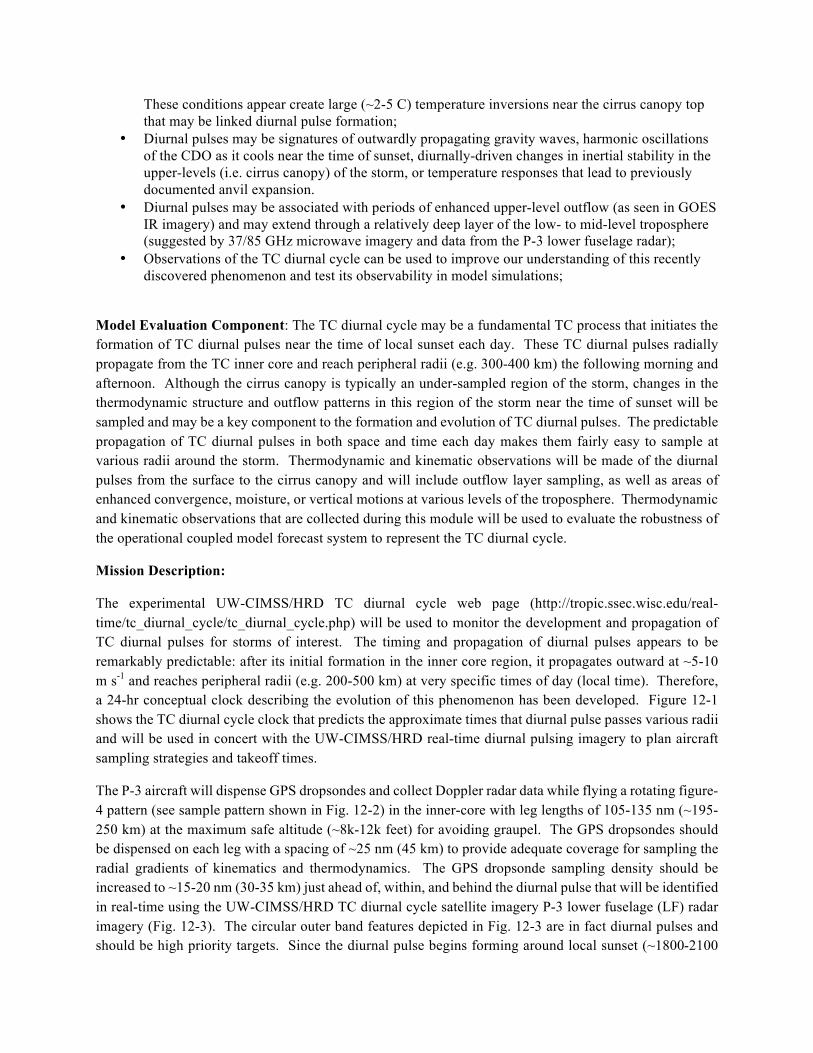
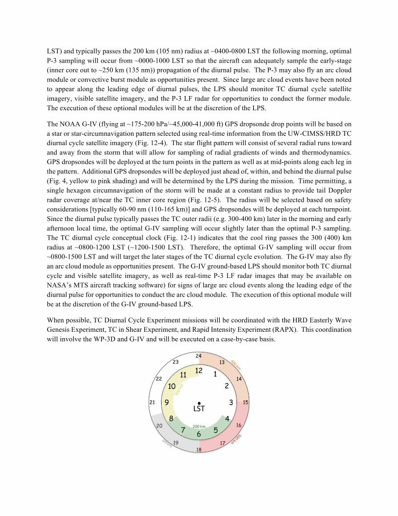
The P-3 aircraft will dispense GPS dropsondes and collect Doppler radar data while flying a rotating figure-4 pattern (see sample pattern shown in Fig. 12-2) in the inner-core with leg lengths of 105-135 nm (~195-250 km) at the maximum safe altitude (~8k-12k feet) for avoiding graupel. The GPS dropsondes should be dispensed on each leg with a spacing of ~25 nm (45 km) to provide adequate coverage for sampling the radial gradients of kinematics and thermodynamics. The GPS dropsonde sampling density should be increased to ~15-20 nm (30-35 km) just ahead of, within, and behind the diurnal pulse that will be identified in real-time using the UW-CIMSS/HRD TC diurnal cycle satellite imagery P-3 lower fuselage (LF) radar imagery (Fig. 12-3). The circular outer band features depicted in Fig. 12-3 are in fact diurnal pulses and should be high priority targets. Since the diurnal pulse begins forming around local sunset (~1800-2100
LST) and typically passes the 200 km (105 nm) radius at ~0400-0800 LST the following morning, optimal P-3 sampling will occur from ~0000-1000 LST so that the aircraft can adequately sample the early-stage (inner core out to ~250 km (135 nm)) propagation of the diurnal pulse. The P-3 may also fly an arc cloud module or convective burst module as opportunities present. Since large arc cloud events have been noted to appear along the leading edge of diurnal pulses, the LPS should monitor TC diurnal cycle satellite imagery, visible satellite imagery, and the P-3 LF radar for opportunities to conduct the former module. The execution of these optional modules will be at the discretion of the LPS.
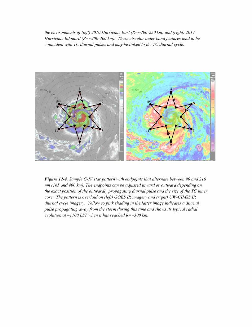
The NOAA G-IV (flying at ~175-200 hPa/~45,000-41,000 ft) GPS dropsonde drop points will be based on a star or star-circumnavigation pattern selected using real-time information from the UW-CIMSS/HRD TC diurnal cycle satellite imagery (Fig. 12-4). The star flight pattern will consist of several radial runs toward and away from the storm that will allow for sampling of radial gradients of winds and thermodynamics. GPS dropsondes will be deployed at the turn points in the pattern as well as at mid-points along each leg in the pattern. Additional GPS dropsondes will be deployed just ahead of, within, and behind the diurnal pulse (Fig. 4, yellow to pink shading) and will be determined by the LPS during the mission. Time permitting, a single hexagon circumnavigation of the storm will be made at a constant radius to provide tail Doppler radar coverage at/near the TC inner core region (Fig. 12-5). The radius will be selected based on safety considerations [typically 60-90 nm (110-165 km)] and GPS dropsondes will be deployed at each turnpoint. Since the diurnal pulse typically passes the TC outer radii (e.g. 300-400 km) later in the morning and early afternoon local time, the optimal G-IV sampling will occur slightly later than the optimal P-3 sampling. The TC diurnal cycle conceptual clock (Fig. 12-1) indicates that the cool ring passes the 300 (400) km radius at ~0800-1200 LST (~1200-1500 LST). Therefore, the optimal G-IV sampling will occur from ~0800-1500 LST and will target the later stages of the TC diurnal cycle evolution. The G-IV may also fly an arc cloud module as opportunities present. The G-IV ground-based LPS should monitor both TC diurnal cycle and visible satellite imagery, as well as real-time P-3 LF radar images that may be available on NASA’s MTS aircraft tracking software) for signs of large arc cloud events along the leading edge of the diurnal pulse for opportunities to conduct the arc cloud module. The execution of this optional module will be at the discretion of the G-IV ground-based LPS.
When possible, TC Diurnal Cycle Experiment missions will be coordinated with the HRD Easterly Wave Genesis Experiment, TC in Shear Experiment, and Rapid Intensity Experiment (RAPX). This coordination will involve the WP-3D and G-IV and will be executed on a case-by-case basis.
Figure 12-1. Conceptual 24-hr TC diurnal cycle clock that outlines the lifecycle of diurnal pulses propagating away from the TC inner core. The diurnal pulse typically forms at local sunset (~1800-2030 LST, gray shading) and begins to propagate away form the inner core, passing the 200 km radius at ~0400-0800 LST (green shading) the following morning. It eventually reaches the 400 km radius at ~1200-1500 LST (orange shading) in the early afternoon.
Figure 12-2. Sample P-3 rotated figure-4 flight pattern. The red shading denotes locations where vertical spacing of Doppler beam < 0.7 km, grey shading where vertical spacing < 1.4 km. GPS dropsondes should be released at all turn points (past the turn after the aircraft has leveled), at midpoints of inbound/outbound legs, at the centers point between IP/2 and 5/6, and across the TC diurnal pulse.
Figure 12-3. P-3 lower fuselage radar showing 25-40 dBZ circular convective bands in
the environments of (left) 2010 Hurricane Earl (R=~200-250 km) and (right) 2014 Hurricane Edouard (R=~200-300 km). These circular outer band features tend to be coincident with TC diurnal pulses and may be linked to the TC diurnal cycle.
Figure 12-4. Sample G-IV star pattern with endpojnts that alternate between 90 and 216 nm (165 and 400 km). The endpoints can be adjusted inward or outward depending on the exact position of the outwardly propagating diurnal pulse and the size of the TC inner core. The pattern is overlaid on (left) GOES IR imagery and (right) UW-CIMSS IR diurnal cycle imagery. Yellow to pink shading in the latter image indicates a diurnal pulse propagating away from the storm during this time and shows its typical radial evolution at ~1100 LST when it has reached R=~300 km.

Figure 12-5. Same as in Fig. 12-4, except that a circumnavigation of the storm is performed after (or before) the star pattern is completed. The hexagon circumnavigation that is shown has points that are 90 nm (165 km) from the storm center, but can be adjusted outward for safety considerations depending on the strength and size of the TC.
Analysis Strategy
This experiment seeks to observe the formation and evolution of the TC diurnal cycle and associated diurnal pulses. Specifically, GPS dropsonde and radar observations will be used to analyze both the inner-core and environmental kinematics and thermodynamics that may lead to the formation of diurnal pulses and to document the kinematics and thermodynamics that are associated with TC diurnal pulses at various stages of their evolution.
Coordination with Supplemental Aircraft
NOAA will be conducting its Sensing Hazards with Operational Unmanned Technology (SHOUT) mission from 01 Aug – 30 Sep 2015. This field campaign will utilize one unmanned Global Hawk (GH) aircraft based from the NASA Wallops Flight Facility and will fly at approximately 55,000-60,000 ft altitude with mission durations of ~24 h. The GH will be used to sample both the TC inner core and surrounding environment. The primary science goals of SHOUT are to use adaptive GPS dropsonde sampling strategies to improve model forecasts of track and intensity, as well as to investigate processes in the TC inner core, boundary layer, and upper-level environment that impact intensity change and structure.
When possible, it will be desirable to fly P-3 and G-IV patterns that are coordinated with the GH (see Fig.

12-6 for sample flight patterns). “Coordinated” means a) designing tracks that provide enhanced spatial and/or temporal sampling between the different aircraft; b) flying radial penetrations where the P-3 and GH or WB-57 are vertically-stacked (the P-3 will be the low-altitude aircraft) for at least a portion of the flight leg, preferably when the aircraft are approaching the center of the TC; or c) coordinating missions that are flown on alternating days by the various aircraft. The across-track displacement during stacked coordination should be kept as small as practicable, e.g., no greater than 5-10 km. In practice, the NOAA P-3 will likely fly its planned figure-4/butterfly/rotating figure-4 patterns as indicated in Fig. 2. It should be noted that the GH can fly patterns that are similar in geometry to the NOAA P-3 patterns (Fig. 6). The G-IV pattern could either be designed/timed to supplement simultaneous coverage by the GH or could supplement storm environment coverage on days when the GH is not flying the storm.
Figure 12-6. Sample flight patterns for the NOAA SHOUT Global Hawk aircraft. (Left) Series of 3 alternating radial leg butterfly patterns and (right) rotated butterfly pattern with 30 degree rotated radial legs. On-station time for both patterns is ~15-20 hr and leg lengths are ~450 km.