12. Geology and soils - Roads and Maritime Services · 12. Geology and soils ... Given the presence...
12
NSW ROADS AND TRAFFIC AUTHORITY | 191 12. Geology and soils 12.1 Assessment approach PB completed a geotechnical investigation based on the developing concept design for the proposed upgrade in November 2005. This study included investigations into subsurface conditions and design parameters along the proposed upgrade for input into the development of the concept design and to identify potential geotechnical and soil issues for this Environmental Assessment. The geotechnical works for this investigation were undertaken between November 2004 and April 2005 and included a review of existing information and the results of previous investigations; investigative boreholes, including acoustic imaging; extraction of core samples; sampling of groundwater and measurement of groundwater levels; identification of acid sulfate soils; cone penetration tests; test pits; seismic refraction traverses; and geotechnical laboratory testing. The results of the assessment are detailed in the unpublished technical report Kempsey to Eungai Pacific Highway Upgrade - Geotechnical Investigations for Concept Design, Geotechnical Investigation Report (NSW Roads and Traffic Authority 2005) and summarised in this Chapter. 12.2 Overview of existing geology and soils 12.2.1 Topography The topography along the proposed upgrade varies considerably; however, it can be broadly categorised into two general landforms, as follows: The Macleay River floodplain (including the Collombatti Creek floodplain), which generally occurs over the central part of the proposed upgrade. Undulating ground, which generally occurs over the southern and northern sections of the proposed upgrade. A profile of the topography (also indicating underlying geology) along the proposed upgrade is illustrated in Figure 12-1. South of the Macleay River floodplain, the proposed upgrade passes through undulating terrain with elevations of up to 50 metres Australian height datum (AHD). The proposed upgrade also passes to the east of the East Kempsey wetland, which has an elevation ranging from 1-6 metres AHD. The Macleay River floodplain is located mostly to the north-east of Kempsey, surrounding the Macleay River and its tributaries. The Macleay River flows to the north-east before entering the South Pacific Ocean at South West Rocks. The proposed upgrade crosses the floodplain for around 4 kilometres, between Stations 9500 and 13500. The average elevation of the floodplain through this area is approximately 2 metres AHD. The proposed upgrade crosses the Macleay River near Station 12400, where the river is about 300 metres wide. Frederickton is located to the north-west of the river on a topographic high point at an elevation of about 15 metres AHD. The Collombatti Creek floodplain is located to the north of the Macleay River floodplain and has an average elevation of approximately 1 metre AHD. The proposed upgrade crosses this floodplain between Stations 18650 and 21200 over a length of some 2.5 kilometres. North- west of Frederickton and south of the Collombatti Creek floodplain, the proposed upgrade passes through gently undulating ground, varying in elevation from approximately 2.5-18 metres AHD. • •
Transcript of 12. Geology and soils - Roads and Maritime Services · 12. Geology and soils ... Given the presence...

NSW ROADS AND TRAFFIC AUTHORITY | 191
12. Geology and soils
12.1 Assessment approach
PB completed a geotechnical investigation based on the developing concept design for the proposed upgrade in November 2005. This study included investigations into subsurface conditions and design parameters along the proposed upgrade for input into the development of the concept design and to identify potential geotechnical and soil issues for this Environmental Assessment.
The geotechnical works for this investigation were undertaken between November 2004 and April 2005 and included a review of existing information and the results of previous investigations; investigative boreholes, including acoustic imaging; extraction of core samples; sampling of groundwater and measurement of groundwater levels; identifi cation of acid sulfate soils; cone penetration tests; test pits; seismic refraction traverses; and geotechnical laboratory testing.
The results of the assessment are detailed in the unpublished technical report Kempsey to Eungai Pacifi c Highway Upgrade - Geotechnical Investigations for Concept Design, Geotechnical Investigation Report (NSW Roads and Traffi c Authority 2005) and summarised in this Chapter.
12.2 Overview of existing geology and soils
12.2.1 Topography
The topography along the proposed upgrade varies considerably; however, it can be broadly categorised into two general landforms, as follows:
The Macleay River fl oodplain (including the Collombatti Creek fl oodplain), which generally occurs over the central part of the proposed upgrade.
Undulating ground, which generally occurs over the southern and northern sections of the proposed upgrade.
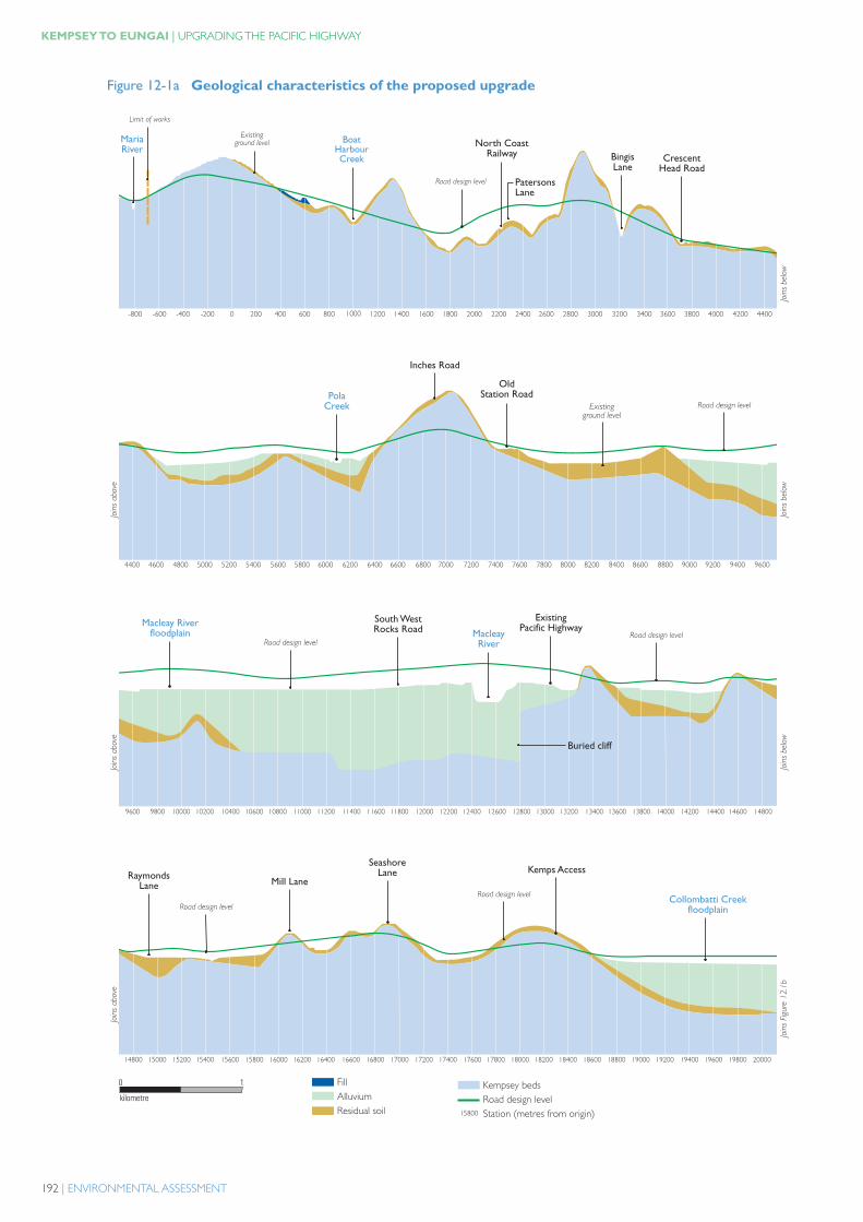
A profi le of the topography (also indicating underlying geology) along the proposed upgrade is illustrated in Figure 12-1. South of the Macleay River fl oodplain, the proposed upgrade passes through undulating terrain with elevations of up to 50 metres Australian height datum (AHD). The proposed upgrade also passes to the east of the East Kempsey wetland, which has an elevation ranging from 1-6 metres AHD.
The Macleay River fl oodplain is located mostly to the north-east of Kempsey, surrounding the Macleay River and its tributaries. The Macleay River fl ows to the north-east before entering the South Pacifi c Ocean at South West Rocks. The proposed upgrade crosses the fl oodplain for around 4 kilometres, between Stations 9500 and 13500. The average elevation of the fl oodplain through this area is approximately 2 metres AHD. The proposed upgrade crosses the Macleay River near Station 12400, where the river is about 300 metres wide. Frederickton is located to the north-west of the river on a topographic high point at an elevation of about 15 metres AHD.
The Collombatti Creek fl oodplain is located to the north of the Macleay River fl oodplain and has an average elevation of approximately 1 metre AHD. The proposed upgrade crosses this fl oodplain between Stations 18650 and 21200 over a length of some 2.5 kilometres. North-west of Frederickton and south of the Collombatti Creek fl oodplain, the proposed upgrade passes through gently undulating ground, varying in elevation from approximately 2.5-18 metres AHD.
•
•
192 | ENVIRONMENTAL ASSESSMENT
KEMPSEY TO EUNGAI | UPGRADING THE PACIFIC HIGHWAY
Figure 12-1a Geological characteristics of the proposed upgrade
#/���� ���� �������
���������� ������
1>22 1?22 1@22 1722 2 722 @22 ?22 >22 6222 6722 6@22 6?22 6>22 7222 7722 7@22 7?22 7>22 8222 8722 8@22 8?22 8>22 @222 @722 @@22
@?22@@22 @>22 4222 4722 4@22 4?22 4>22 ?222 ?722 ?@22 ??22 ?>22 A222 A722 A@22 A?22 A>22 >222 >722 >@22 >?22 >>22 B222 B722 B@22 B?22
B?22 B>22 62222 62722 62@22 62?22 62>22 66222 66722 66@22 66?22 66>22 67222 67722 67@22 67?22 67>22 68222 68722 68@22 68?22 68>22 6@222 6@722 6@@22 6@?22 6@>22
6@>22 64222 64722 64@22 64?22 64>22 6?222 6?722 6?@22 6??22 6?>22 6A222 6A722 6A@22 6A?22 6A>22 6>222 6>722 6>@22 6>?22 6>>22 6B222 6B722 6B@22 6B?22 6B>22 72222
0�� ����
���
0�� ����
���
0�� ����
���
0�� ����
���
0�� ����
���
0�� ����
���
0�� ��*��
���%-
1%�
64>22
��������+��&�������������
#�&*����'�����������������+�� �������:&������(��&�������;
�
�������
�
�.����*'.(*�*��+
.*�1��.�2��,���& �*�2)� �
���!�.�!
��*,�,-�*
#/���� ���� �������
�.���*��+
��!����,. �.�!
���������� ������
��)���&�,-�*6�..!3��, ���������� ������
���������� ������
�.(�1���2�.)+2�.�! ��)���&
,-�*
�9,2�, 0��),6,)��,01��&
�(*,�!�)�,66
���������� ������
���������� ������
�&/. !2 � � �,��� � �
���21.*� � � ��/32��))�22
�.��./'���,��*��+6�..!3��,
2������3������
����*2. 2 � �
�, 0,2 � �
� )1�2�.�!

NSW ROADS AND TRAFFIC AUTHORITY | 193
CHAPTER 12 | GEOLOGY AND SOILS
Figure 12-1b Geological characteristics of the proposed upgrade
72222 72722 72@22 72?22 72>22 76222 76722 76@22 76?22 76>22 77222 77722 77@22 77?22 77>22 78222 78722 78@22 78?22 78>22 7@222 7@722 7@@22 7@?22 7@>22 74222 74722
74722 74@22 74?22 74>22 7?222 7?722 7?@22 7?@22 7??22 7?>22 7A222 7A722 7A@22 7A?22 7A>22 7>222 7>722 7>@22 7>?22 7>>22 7B222 7B722 7B@22 7B?22 7B>22 82222 82722
82722 82@22 82?22 82>22 86222 86722 86@22 86?22 86>22 87222 87722 87@22 87?22 87>22 88222 88722 88@22 88?22 88>22 8@222 8@722 8@@22 8@?22 8@>22 84222 84722 84@22
84@22 84?22 84>22 8?222 8?722 8?@22 8??22 8?>22 8A222 8A722 8A@22 8A?22 8A>22 8>222 8>722 8>@22 8>?22 8B222 8B722 8B@22 8B?228>>22
0�� ����
���
0�� ����
���
0�� ����
���
0�� ����
���
0�� ����
���
0�� ����
���
0�� ��*��
���%-
1%�
8A222
�
�������
� ��������+��&�������������
#�&*����'�����������������+�� �������:&������(��&�������;
���������� ������
#/���� ���� �������
�.��./'���,��*��+6�..!3��,
��-� ��,��2.�!
���������� ������
#/���� ���� �������
���������� ������
#/���� ���� �������
�..+2� � � �,��2� � � ,*-� ����&
#/���� ���� �������
���������� ������
��**�0� &���,�(��.�! ��(�*�2��., �
.�!
�*(21'.9 � � .*�1��.�2�
�,���&����,. ��*���

194 | ENVIRONMENTAL ASSESSMENT
KEMPSEY TO EUNGAI | UPGRADING THE PACIFIC HIGHWAY
North of the Collombatti Creek fl oodplain, the proposed upgrade passes through undulating to strongly undulating terrain, with rounded hill crests and ridges, and some isolated alluvial pockets in valleys. The hills along this section of the proposed upgrade generally rise to a maximum of 45 metres AHD.
12.2.2 Geology and soils
Kempsey lies within the eastern section of the New England Fold Belt, which comprises a mosaic of fault bounded blocks. Reference to the 1:100,000 Geological Series Sheet 9435 for Kempsey (NSW Geological Survey 1988a) and Sheet 9436 for Macksville (NSW Geological Survey 1988b) indicates that Kempsey is located within the Hastings Block, close to its northern boundary with the Nambucca Slate Belt.
The proposed upgrade passes through two physiographic regions, namely coastal alluvial plains and undulating to strongly undulating low hills. Figure 12-1 illustrates the changing topography along the proposed upgrade.
The undulating low hills are underlain by rocks of the Kempsey Beds. The Kempsey Beds comprise predominantly sandstones and mudstones. The sandstones tend to be more resistant to weathering than the mudstones. As such, the soil landscapes on the sandstones are generally more undulating, with steeper slopes than those on mudstones. The Kempsey Beds underlie approximately two thirds of the proposed upgrade.
Within the coastal alluvial plains to the north and south of the Macleay River, the rocks of the Kempsey Beds are generally overlain by Quaternary sediments. The coastal alluvial plains occur extensively in the coastal lowlands to the east and north-east of Kempsey, covering approximately one third of the proposed upgrade. These areas include the fl oodplains and estuaries of the Macleay River, Collombatti Creek and coastal swamps. The alluvial sediments associated with these areas comprise unconsolidated sands, silts, clays and gravels in active stream channels, fl oodplains, terraces and levees.
The subsurface profi le in the northern section of the proposed upgrade generally comprises residual soils overlying extremely weathered, low strength schistose sandstone and cleaved siltstone/phyllite. The subsurface profi le of the southern part of the proposed upgrade comprises shallow residual soils overlying generally more competent, slightly weathered rocks of medium to very high strength.
Low-lying areas, including the approaches to river crossings north-east of Kempsey, typically contain deep, soft soils that are susceptible to fl ooding and settlement. These areas are also likely to contain potential or actual acid sulfate soils. Soils within the undulating hill areas are commonly shallow and sodic, with a susceptibility to erosion, salinity and acidity.
12.3 Impact of changes to surface and subsurface conditions
12.3.1 Soft soils
Soils of the Macleay River fl oodplain, the East Kempsey wetland and the Collombatti Creek fl oodplain tend to be relatively soft and compressible. Special techniques may need to be applied during construction to minimise post-construction consolidation settlements. A total of 33 fi ll embankments are proposed along the proposed upgrade alignment. The embankments
The proposed upgrade crosses fl at alluvial plains in the Frogmore, Frederickton and Collombatti areas.
The southern and northern ends of the proposed upgrade are more undulating.
The proposed upgrade crosses fl at alluvial plains in the Frogmore, Frederickton and Collombatti areas.
The southern and northern ends of the proposed upgrade are more undulating.

NSW ROADS AND TRAFFIC AUTHORITY | 195
CHAPTER 12 | GEOLOGY AND SOILS
would range between approximately 1.7 and 12.5 metres in height as shown on Figure 12-1. Approximately half of the fi ll embankments would be constructed on estuarine and alluvium soils associated with the East Kempsey wetland, the Macleay River fl oodplain and the Collombatti Creek fl oodplain. The soft soil layers in these areas vary in depth and are generally underlain by residual soils and weathered rock.
The stress increase caused by the construction of fi ll embankments on soft soils would induce compression of the soil layers and settlement of the constructed embankment. Compression of the soil layers results from deformation of soil particles, relocation of soil particles and expulsion of water and/or air from void spaces.
On the Macleay River fl oodplain, the East Kempsey wetland and the Collombatti Creek fl oodplain, where fi ll embankments would be constructed over soft compressible alluvial deposits, both primary and secondary consolidation settlement could continue after completion of embankment construction. This is expected to be considerable. The magnitude and rate of settlement would be infl uenced by various factors, including the thickness of the soft layers and the physical parameters of the materials, as well as the application of various engineering measures in design and construction, particularly ground treatment.
Water displaced vertically during consolidation of the underlying layers may discharge to the surface either by natural drainage paths or through the use of vertical wick drains installed to accelerate settlement. This water would be collected and directed to a detention basin for treatment, prior to discharge to natural watercourses.
Construction schedulingGiven the presence of extensive areas of soft soils, embankment construction would require staging and the application of ground treatment measures to manage consolidation settlement within the available construction period and project performance parameters, particularly the residual settlement that is acceptable after completion of construction. Fill for embankments would most likely be sourced from proposed cuts within the proposed upgrade. Construction scheduling may necessitate importation of some materials for bridging layers and/or general fi ll, depending on the overall project staging and ground improvement methods adopted by the construction contractor. The construction of embankments on soft soils, with associated drainage, preloading and surcharging, and subsequent relocation of some materials, would require careful planning. Impacts on embankment construction and factors for consideration in the development of a staging strategy are detailed in Chapter 7 - Detailed design and construction of the proposed upgrade.
Construction traffi c access on soft soilsA surface crust is generally present along much of the lowland areas of the proposed upgrade, with the exception of some swampy areas. The presence and strength of the surface crust varies depending on prevailing weather conditions. During periods of dry weather, the surface crust would be quite pronounced and may enable the lowlands to be traffi cked by light equipment. However, during periods of wet weather, the surface crust would be expected to be markedly weaker, making traffi cking conditions poor for even very light or track-mounted equipment.
It is expected that bridging layers would be required for access across lowlands sections of the project, particularly adjacent to watercourses. Requirements for bridging layers would be determined by the construction contractor with consideration of conditions at the time of construction and the ground treatment methods ultimately adopted for construction.
What are soft soils?
Soft soils are mostly consolidated or slightly over-consolidated clays, with varying proportions of organic material, silts and sands (Transport Research Laboratory 1994).
When a load, such as an embankment, is applied to such soils, there is potential for downward movement to cause damage to the embankment and surface infrastructure such as pavements as illustrated in the accompanying photograph.

196 | ENVIRONMENTAL ASSESSMENT
KEMPSEY TO EUNGAI | UPGRADING THE PACIFIC HIGHWAY
12.3.2 Cut slope areas
The 24 cuttings included in the concept design for the proposed upgrade would have approximate depths ranging from 1–28 metres. The materials exposed in cut batters would comprise residual silty clay soils and extremely weathered, very low strength sandstone/siltstone, grading to moderately weathered rock of medium strength with increasing depth. The majority of excavations would be in residual soils and weathered siltstone/sandstone.
Excavation for four cuttings up to approximately 20 metres deep at the southern end of the proposed upgrade (south of Kempsey) would mostly encounter moderately to slightly weathered, medium to extremely high strength sandstone and siltstone. Some blasting would be required at these locations. Four other cuts would be expected to be largely in residual soils. The remaining cuts would be excavated in highly weathered, low strength rock grading to medium strength with increasing depth.
All rock cuttings along the alignment, with the exception of one, have been designed with batter slopes of 2 metre horizontal (2H):1 metre vertical (1V), to a height of 7 metres, with 4 metre wide benches in between. The exception to this rule is Cut 3 (Station 2710 to 3120, refer to Figure 12-1), the deepest cutting in the concept design, where the fi rst two batters above road level are designed at 0.5H:1V in rock, adopting the same batter heights and bench widths.
Because of the steep batter slopes in Cut 3 (63 degree slopes), the RTA completed a preliminary kinematic assessment, using currently available geotechnical data, to assess the likelihood of wedge/sliding/toppling type failures in this cut.
On the basis of this assessment, rock bolting would most likely to be required within this cutting to restrain unfavourably oriented rock wedges. Further assessment would be carried out during detailed investigations or on-site as the excavation proceeds to determine any appropriate remediation measures. Suffi cient provision has been made in determining the proposed road boundaries at this location to allow for the general adoption of 2H:1V batters in this cutting should that be deemed the preferred approach for construction.
Two faults trending north-east and north-west would increase the possibility of defect zones or adverse joint orientation, which may impact on the cut batter design in the northern part of the proposed upgrade from Station 16000.
Due to the inclination of the joints and some rock bed partings, it is expected that some local remedial protection measures for the rocks slopes would be required. These measures are described in Section 12.4.2. Some minor slumping and rock falls may occur, particularly if the batter face is subjected to scouring.
The planned use of material obtained from cuttings during embankment construction may be affected by the overall construction staging. Material may not be extracted from cuttings early enough to be reused in embankment loading on soft soils in low-lying areas. There is some fl exibility in the amount of material available as the road boundary has been set for batters at 2H:1V where it may be possible to construct steeper batters.
12.3.3 Contaminated land
An investigation into the potential for contaminated land along or adjacent to the proposed upgrade was undertaken from February to March 2005 (NSW Roads and Traffi c Authority 2005). This investigation found a low potential for contaminants of concern. Furthermore, as the proposed change in land use along much of the proposed upgrade would be to a less sensitive use (from rural to road), should any contamination be present, it would be unlikely to pose a risk to future road users or the public.
NSW ROADS AND TRAFFIC AUTHORITY | 197
CHAPTER 12 | GEOLOGY AND SOILS
The proposed upgrade would pass through or near several nurseries where pesticides, herbicides and/or fungicides may have been used. It is unlikely that there would be suffi cient residue of these substances in the soil to pose a risk to the environment or human health.
There are also several service station sites in the area; however, they are located a considerable distance from the proposed upgrade (over 1 kilometre). It is therefore unlikely that there would be any contaminated soils or groundwater from this source beneath or adjacent to the proposed upgrade.
It is therefore unlikely that contaminants are present along the proposed upgrade at levels that would pose a risk to construction workers, users of the proposed upgrade, or the general public. However, several areas were considered to warrant further soil contamination investigation, as discussed in Section 12.4.3.
12.3.4 Acid sulfate soils
When drainage or excavation results in aeration of potential acid sulfate soil materials, bringing them into contact with oxygen, oxidisation occurs, causing the pyrite material to form sulfuric acid. Any form of disturbance that brings the potential acid sulfate soil materials into contact with oxygen leads to the development of actual acid sulfate soil layers. Potential acid sulfate soils are harmless to the environment as long as they remain waterlogged (Department of Land and Water Conservation 1998b). Acid sulfate soil materials are commonly found in low-lying areas (generally below 5 metres AHD) along the east coast of NSW within estuarine sediments of the Holocene geological age.
Potential acid sulfate soil materials occur in low-lying areas, such as the Macleay River fl oodplain. The management of surface and groundwater fl ows is important in maintaining suitable conditions for pasture growth in these areas.
Off-site effects of the exposure of potential acid sulfate materials to oxygen include fl ushing of extremely acid and aluminium rich toxic water during rain. Acid water contamination can have serious implications for aquatic ecology and commercial fi sheries, including fi sh kills and fi sh disease outbreak. In addition, corrosion of concrete and steel by acids and salts can cause serious problems for infrastructure and require signifi cant expenditure on maintenance of public structures.
A review of acid sulfate soil risk mapping indicated a high potential for the presence of potential acid sulfate soil materials in a number of areas along the proposed upgrade as illustrated in Figure 12-2. Field and laboratory tests conducted during the geotechnical investigations confi rmed the acid sulfate soil risk map, indicating that 20% of the potential acid sulfate soil values were below the threshold pH for active acid sulfate materials. These potential acid sulfate soil materials lie within the alluvium layers of the Macleay River fl oodplain and generally comprise very soft to soft alluvial (sandy/silty) clays.
12.3.5 Erosion
The potential for erosion (and sedimentation) as a result of the construction of the proposed upgrade can be mitigated adequately with conventional measures, such as those outlined in the Landcom publication Managing urban stormwater: soils and construction (Landcom 2006).
Scour occurs when water fl ows of suffi cient velocity erode and carry soil particles, causing turbidity and sedimentation. This can have an adverse effect on aquatic ecology and result in changes to waterway morphology. Scour may occur where the size of a channel is reduced or
What are acid sulfate soils?
Potential acid sulfate soils are waterlogged soils that are rich in iron sulfi des (pyrite).
Actual acid sulfate soils are the extremely acidic soils that result from the disturbance or drainage and subsequent oxidation of previously waterlogged potential acid sulfate soils. The effects of acid sulfate soil scalding in an area to the east of the proposed upgrade are illustrated in the accompanying aerial photograph.

198 | ENVIRONMENTAL ASSESSMENT
KEMPSEY TO EUNGAI | UPGRADING THE PACIFIC HIGHWAY
Figure 12-2 Acid sulfate soil risk map
������
�����������
����
���
�����
�����������������
������������������������������
��������������� �
�
����������������������
�������������������������������������������������� �
� �� �
������ �
� �
��� �
� � � � � � ������� �
� �
�������� �
� ������������������������� �
� � � �
��
�
������
��� �
����
�����
�� �
� � � � �
��
������������ �
� � �� � �
��
�
����
� �
��
������������
�����������
���������� ����
�������
����
��
��������
������
������
����
������������
�������������
�������������
������� �����������������
�� ���� ����
!������������
����������
����
��� "���
���!��������
���������� ����
������
����
�����
����
�����������
���� �������������
������
���������
#��������
�������������
# ���
����
"��������
�������
�����
� ���� �
�����
��������
��������
� ������
� ������
������������
�����
�� ���������
���������
������ ��������� �
� !� ���"�� ��������� �
#� ������� ��������� �
���"���"������"��� ����#
$���$��!���"��� ����#
%������ $��� ����
�� �������
�������
�� � &���
����
�����
������
� ���
%
����&'���� ����
���(�$���
)��
������
��
��
���&&��� �
��
���(�
$���
)��
,
�����
%��������)��
*��
������+���
�
&�����)�����
����%�������
����
���'��
�����
����� ���
������������
,�)����
����
����������-�����
������+����
��*��� %��� ��
��
�,��������.���� ����
����������
���� �
$�����
���
$��� %��������
"����
����
������ ��������� �
������
�� �������
��
��������
�
�������*���������)�����������(��������(���������
�)�*��'�'�������������(����������:'��)���6�����8�&������'���)���������������(��; �)�*��'�'�������������(����������:������������8�&������'���)���������������(��;
$����*��'�'�������������(����������:������������������������(��;$����*��'�'�������������(����������:'��)���6�����8�&������'���)���������������(��;
�����'.�
�����3����������
�����3��!�����
����4�
����!����5�
������
� ���
3�2�
���
��������� �������� �%6
678

NSW ROADS AND TRAFFIC AUTHORITY | 199
CHAPTER 12 | GEOLOGY AND SOILS
where a channel is steepened, including at the point of change from natural waterway channel to culvert inlet. Waterways and drains that do not have soil stabilising vegetation are more susceptible to erosion and scour. Scour is an important potential issue that will be considered and addressed in the detailed design of drainage culverts for the proposed upgrade.
Further details on water quality are provided in Section 21.1.
12.4 Management of impacts
12.4.1 Soft soils
Soft soil conditions that may be encountered during construction of the proposed upgrade would need to be treated using various methods, depending on the local ground conditions, construction scheduling, and the availability of suitable construction materials. In general, stability or settlement problems associated with the construction of embankments on soft soils/sediments may be controlled using various approaches.
Special construction techniques that could be applied include providing surcharge (additional temporary fi ll) for a specifi ed time period on top of fi ll embankments to accelerate the rate of consolidation, so as to reduce the amount of residual settlement expected following construction of the road pavement and bridges. Other methods of dealing with the potential settlement of fi ll embankments on soft soils include the installation of wick drains, supporting piles or stone columns prior to placement of the embankment fi ll material, vacuum consolidation or other techniques.
Further detailed geotechnical studies would be undertaken during detailed design to identify the extent and specifi c properties of the soft soils and to precisely determine the extent of surcharge and duration of loading required and the techniques that will be used. Removal of soft soils is not a viable option, as this would require excavation to signifi cant depths over relatively large areas and would also result in disturbance of acid sulfate soil materials.
Management strategies for construction on soft soils would be further developed during detailed design. The construction contractor will evaluate and select the most suitable construction methods for each location based on the consideration of the detailed geotechnical investigations, prevailing weather conditions, construction equipment to be used and the construction program.
Subgrade preparationAs previously noted, construction of sections of the proposed upgrade through low-lying areas characterised by soft alluvial sediments has the potential to affect acid sulfate soils. A number of alternative subgrade preparation measures may be used in these areas. In practice, the high probability of occurrence of acid sulfate soils (as discussed in Section 12.3.4) in these areas requires the application of construction approaches that minimise disturbance of foundation materials.
The removal of highly compressible materials, including topsoil and clays (soft or fi rm), and the replacement of these with more competent materials, could require the disturbance, treatment and disposal of large quantities of acid sulfate generating materials. This is not preferred due to design considerations and the impacts associated with disturbed potential acid sulfate soils on infrastructure, land use and the environment, but may need to be used in some cases.
Exposed areas of soil are prone to erosion.
Delivery of eroded sediment to waterways results in high turbidity levels and sedimentation.
Exposed areas of soil are prone to erosion.
Delivery of eroded sediment to waterways results in high turbidity levels and sedimentation.

200 | ENVIRONMENTAL ASSESSMENT
KEMPSEY TO EUNGAI | UPGRADING THE PACIFIC HIGHWAY
The construction contractor will determine the most suitable method for subgrade preparation on-site, considering the soils, geotechnical issues, prevailing weather conditions, construction methodology adopted, construction program and options available.
In some areas away from the low-lying sections of the proposed upgrade that are unlikely to be affected by acid sulfate soils, unsuitable materials such as topsoil and other soft compressible material would be removed and replaced prior to placement of embankment materials. Replacement materials would be placed and compacted to the same requirements as embankment fi ll.
Bridges and structure footingsAs detailed in Section 6.1, the structures to be constructed on soft soils/sediments along the proposed upgrade would include:
Bridge crossings over the Macleay River, Collombatti Creek and Pola Creek.
Bridges over the Macleay River fl oodplain in conjunction with fi ll embankments.
In soft soil areas comprising softer, less dense alluvium, the bridge structures would be supported on piles extending through the soft soil layers and founded in more competent material to comply with design criteria. In areas comprising dense to very dense granular alluvium, the bridge structure would most likely be supported on shallow footings founded on more competent material. Driven piles are the preferred footing type where unstable ground conditions are expected and/or where acid sulfate soil material is anticipated. Bored piles would be likely to be used in other locations. Where driven bridge piles are proposed in soft compressible soils, the installation of the piles would be delayed until settlement of the adjoining embankment fi ll is substantially complete.
12.4.2 Cut slopes
On the basis of the geotechnical investigations completed to date, it is expected that some local remedial protection measures would be required for cut batters. These measures may include rock bolts, mesh and other methods such as shotcreting. In the worst affected locations, batter slope fl attening would be required. The objective of such measures is to improve the stability of cut slopes; the measures would not necessarily prevent minor ravelling and weathering of cut slopes. The need for and locations of these measures would be determined as part of the detailed design and geotechnical investigations or during construction, after cuttings are established and the insitu batter material has been assessed.
It is expected that all batters would be subject to engineering inspection during the initial stages of construction. In addition, regular inspections by an engineering geologist would be undertaken during excavation to identify any potentially de-stabilising seams or steeply inclined joints. If unfavourable jointing is encountered, the bedrock would have to be battered at a fl atter slope or other stabilising methods, such as shotcrete and/or rocks bolts be applied.
Care would be taken to avoid over-excavation and to maintain batter stability throughout construction. Appropriate surface drainage systems would be provided around the crest and benches of all cut batters to assist in management of erosion and sedimentation.
12.4.3 Contaminated land
Using the recommended environmental management measures throughout the construction of the proposed upgrade, as detailed in the draft Statement of Commitments (Appendix D), excavation of soils along the proposed upgrade would be unlikely to pose an environmental or human health risk.
•
•

NSW ROADS AND TRAFFIC AUTHORITY | 201
CHAPTER 12 | GEOLOGY AND SOILS
Further soil contamination investigation will be required in some areas during detailed investigation and design. These will include:
At Frederickton interchange where a sewage treatment plant and a possible waste disposal centre are located.
The southern section of the proposed upgrade, where the new road diverts from the existing Pacifi c Highway within the South Kempsey commercial area where existing and historic land uses may have contributed to soil contamination.
These investigations would incorporate a detailed inspection of the sites to evaluate the nature of the land use and detect any evidence of potential contamination. If the site inspection fi nds any evidence of contamination, further investigations including sampling and analysis of soils for contaminants may be required.
If contaminated land is encountered prior to or during construction, conventional mitigation and management measures would be applied. These measures are included in the draft Statement of Commitments for the proposed upgrade in Appendix D and outlined in the summary of management measures below.
12.4.4 Acid sulfate soils
The potential engineering and environmental consequences of building a new road on acid sulfate soil materials were taken into account in developing the concept design for the proposed upgrade. They would be further considered in developing the detailed design and environmental management measures to be implemented during construction.
Given the presence of potential acid sulfate soils along the proposed upgrade, an Acid Sulfate Soils Management Plan will be developed and implemented prior to the commencement of earthworks in areas where alluvial deposits are expected to be encountered. The need for an Acid Sulfate Soils Management Plan is identifi ed in the draft Statement of Commitments for the proposed upgrade in Appendix D and outlined in the summary of management measures below.
12.4.5 Erosion
To minimise the effects of scour in association with drainage culverts, appropriate scour protection measures would be incorporated into the design of culverts where necessary. Culverts and scour protection would be designed to be fi sh-friendly where aquatic habitats exist.
Conventional mitigation and management measures would be applied to manage other erosion impacts arising from the construction and operation of the proposed upgrade. These are included in the draft Statement of Commitments for the proposed upgrade in Appendix D and outlined in the summary of management measures below.
12.4.6 Summary of management measures
Mitigation and management techniques for contaminated land, acid sulfate soils as well as erosion and sedimentation arising from the construction and operation of the proposed upgrade are summarised below. They are also included in the draft Statement of Commitments for the proposed upgrade in Appendix D.
•
•

202 | ENVIRONMENTAL ASSESSMENT
KEMPSEY TO EUNGAI | UPGRADING THE PACIFIC HIGHWAY
Contaminated land
A review will be undertaken of land impacted by the proposed upgrade to identify potentially contaminated sites. Potentially contaminated sites will be further investigated in accordance with the RTA’s Contaminated Land Management Guideline.
If site contamination investigations indicate that contaminants are present on the site in concentrations above the intended land use criteria, then an appropriate risk-based management plan approach would be developed in accordance with the RTA’s Contaminated Land Management Guideline.
Where contamination is found to pose unacceptable risk to either the environment or human health receptors, a Remedial Action Plan will be developed and remediation works will be undertaken in consultation with the Department of Environment and Climate Change.
Acid sulfate soils
An Acid Sulfate Soil Management Sub Plan will be prepared and implemented in consultation with relevant government departments as part of the CEMP. The Sub Plan will include a contingency plan to deal with the unexpected discovery of actual or potential acid sulfate soils, measures to manage ASS impacts and will include a water quality monitoring program.
Erosion and sedimentation
A Soil and Water Management Sub Plan will be prepared and implemented in consultation with relevant government departments and Councils as part of the CEMP. The Sub Plan will:
Include the hydrology, water quality and soil management measures listed in the Enviroacnmental Assessment and Submissions Report.
Identify the construction activities that could cause soil erosion or discharge sediment or water pollutants from the site.
Describe management methods to minimise soil erosion or discharge of sediment or water pollutants from the site, including a strategy to minimise the area of bare surfaces during construction.
Include contingency plans to be implemented for events such as fuel spills.
All operation stage controls for stormwater drainage and water pollution will be located, designed, constructed, operated and maintained to meet the requirements of the RTA’s Code of Practice for Water Management – Road Development and Management. These controls will be designed in consultation with relevant government departments and councils.
An appropriately qualifi ed soil conservationist will be appointed according to a schedule identifi ed in the Soil and Water Management Sub Plan to:
Assist in the preparation of progressive erosion and sediment control plans.
Undertake inspections of temporary and permanent erosion and sedimentation control devices.
Ensure that the most appropriate controls are being implemented.
Check that controls are being maintained in an effi cient condition.
Check that controls meet the requirements of any relevant approval and/or licence condition.
Erosion and sedimentation controls will be installed, maintained and managed prior to and during construction. The principles in Managing Urban Stormwater —- Soils and Construction, Volume 2 Book 4 – Main Road Construction (Landcom 2006) will apply.
Sediment will be cleared from behind barriers as required on a regular basis and controls will be monitored and maintained to ensure they work effectively at all times.
Hardstand material, rumble grids, wheel wash or other measures will be installed at entry and exit points to minimise the tracking of soil and particulates onto pavement surfaces.
Scour protection will be installed in creek/river bank areas at risk of erosion as necessary, taking into account fi sh and fauna issues in scour design where possible.
•
•
•
•
•
–
–
–
–•
•
––
–––
•
•
•
•