Mapping to underpin management of tropical littoral rainforest

2 Jacaranda Geography Alive 9 for the Victorian Curriculum
1.1 Overview 1.1.1 Work and careers in Geography Geographical skills will be useful for your future employment. An understanding of Geography and its application for managing sustainable futures is pivotal knowledge that will be desirable to future employers. In Geography, students are developing an understanding of the world. � e skills you develop in Geography are transferrable to the workplace and can be used as a basis for evaluating strategies for the sustainable use and management of the world’s resources.
Skills for work Geography is a foundational skill for many occupations. Learning to navigate further educa-tion and training paths will help you to understand the variety of occupations that the study of Geography can lead to. � e study of Geography includes important geospatial and spatial technology skills. � ese skills underpin the knowledge base of a range of courses and careers. Start your pathways exploration by considering who might use the key geospatial and spatial technologies. • Geospatial skills : the ability to collect and collate information gathered from � eldwork and
observations. Geospatial skills are used in careers such as surveying, meteorology, agricultural science and urban planning.
• Spatial technologies : technologies that demonstrate the connections between location, people and activities in digital formats. Jobs in the spatial industry are varied and include working in business and government. Spatial technologies apply many techniques, such as photogrammetry, remote sensing and global positioning systems (GPS). Spatial technologies manage information about the environment, transportation and other utility systems.
FIGURE 1 GIS (Geographic Information Systems) being used to manage spaces and plan escape routes during a � re
TOPIC 1 THE WORLD OF GEOGRAPHY
c01TheWorldOfGeography.indd 2 27/10/16 7:56 PM
UNCORRECTED about the environment, transportation and other utility systems.
UNCORRECTED about the environment, transportation and other utility systems.
UNCORRECTED
UNCORRECTED
UNCORRECTED GIS (Geographic Information Systems) being used to manage spaces and plan escape routes during a � re
UNCORRECTED GIS (Geographic Information Systems) being used to manage spaces and plan escape routes during a � re PAGE : the ability to collect and collate information gathered from � eldwork and
PAGE : the ability to collect and collate information gathered from � eldwork and observations. Geospatial skills are used in careers such as surveying, meteorology, agricultural
PAGE observations. Geospatial skills are used in careers such as surveying, meteorology, agricultural
: technologies that demonstrate the connections between location, people
PAGE : technologies that demonstrate the connections between location, people
and activities in digital formats. Jobs in the spatial industry are varied and include working in
PAGE and activities in digital formats. Jobs in the spatial industry are varied and include working in business and government. Spatial technologies apply many techniques, such as photogrammetry,
PAGE business and government. Spatial technologies apply many techniques, such as photogrammetry, remote sensing and global positioning systems (GPS). Spatial technologies manage information
PAGE remote sensing and global positioning systems (GPS). Spatial technologies manage information about the environment, transportation and other utility systems.PAGE about the environment, transportation and other utility systems.PAGE P
ROOFSdevelop in Geography are transferrable to the workplace and can be used as a basis for evaluating
PROOFSdevelop in Geography are transferrable to the workplace and can be used as a basis for evaluating
Geography is a foundational skill for many occupations. Learning to navigate further educa-
PROOFS Geography is a foundational skill for many occupations. Learning to navigate further educa-tion and training paths will help you to understand the variety of occupations that the study
PROOFStion and training paths will help you to understand the variety of occupations that the study of Geography can lead to. � e study of Geography includes important geospatial and spatial
PROOFSof Geography can lead to. � e study of Geography includes important geospatial and spatial technology skills. � ese skills underpin the knowledge base of a range of courses and careers.
PROOFStechnology skills. � ese skills underpin the knowledge base of a range of courses and careers. Start your pathways exploration by considering who might use the key geospatial and spatial
PROOFSStart your pathways exploration by considering who might use the key geospatial and spatial
: the ability to collect and collate information gathered from � eldwork and PROOFS
: the ability to collect and collate information gathered from � eldwork and observations. Geospatial skills are used in careers such as surveying, meteorology, agricultural PROOFS
observations. Geospatial skills are used in careers such as surveying, meteorology, agricultural
Topic 1 The world of Geography 3
FIGURE 2 Using GPS to survey and record road traf�c movements for a local council
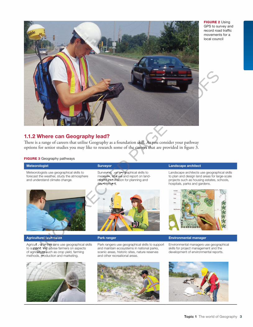
1.1.2 Where can Geography lead?�ere is a range of careers that utilise Geography as a foundation skill. As you consider your pathway options for senior studies you may like to research some of the careers that are provided in �gure 3.
FIGURE 3 Geography pathways
Meteorologist Surveyor Landscape architect
Meteorologists use geographical skills to forecast the weather, study the atmosphere and understand climate change.
Surveyors use geographical skills to measure, analyse and report on land-related information for planning and development.
Landscape architects use geographical skills to plan and design land areas for large-scale projects such as housing estates, schools, hospitals, parks and gardens.
Agricultural technician Park ranger Environmental manager
Agricultural technicians use geographical skills to support and advise farmers on aspects of agriculture such as crop yield, farming methods, production and marketing.
Park rangers use geographical skills to support and maintain ecosystems in national parks, scenic areas, historic sites, nature reserves and other recreational areas.
Environmental managers use geographical skills for project management and the development of environmental reports.
c01TheWorldOfGeography.indd 3 27/10/16 7:56 PM
UNCORRECTED
UNCORRECTED
UNCORRECTED
UNCORRECTED
UNCORRECTED Surveyors use geographical skills to
UNCORRECTED Surveyors use geographical skills to measure, analyse and report on land-
UNCORRECTED measure, analyse and report on land-related information for planning and
UNCORRECTED related information for planning and development.
UNCORRECTED development.
UNCORRECTED
Agricultural
UNCORRECTED
Agricultural technician
UNCORRECTED
technician
Agricultural technicians use geographical skills
UNCORRECTED
Agricultural technicians use geographical skills to support and advise farmers on aspects UNCORRECTED
to support and advise farmers on aspects UNCORRECTED
of agriculture such as crop yield, farming UNCORRECTED
of agriculture such as crop yield, farming methods, production and marketing.UNCORRECTED
methods, production and marketing.
PAGE
PAGE �ere is a range of careers that utilise Geography as a foundation skill. As you consider your pathway
PAGE �ere is a range of careers that utilise Geography as a foundation skill. As you consider your pathway options for senior studies you may like to research some of the careers that are provided in �gure 3.
PAGE options for senior studies you may like to research some of the careers that are provided in �gure 3.
PROOFS
PROOFS

4 Jacaranda Geography Alive 9 for the Victorian Curriculum
ACTIVITIES
1 Select an occupational pro�le that is presented in �gure 3. Use the Job Outlook weblink in the Resources tab to locate the Job Outlook website. At this site you will be able to explore a career that interests you. Job Outlook is a federal government website that provides information on employment in a range of occupations. It also includes information on the training, skills and tools needed for the career that you are researching.
2 Develop a career pro�le for your occupation of choice. In your pro�le include:• the geographical skills needed for this job• the geographical tools that may be used in
this occupation• the study and training requirements that lead
to this occupation• the job prospects for your chosen occupation
over the next �ve years.
3 In Australia, there is a range of industries that employs conservationists, oceanographers or agricultural scientists. Use the Job Outlook weblink in the Resources tab to locate the Job Outlook website to research industries that may deal with land degradation, marine pollution or world food needs. For example, the Agricultural, Forestry and Fishing industries offer all three occupations and list a range of technical and professional tasks in their job descriptions.
Develop a job description for one of the occupations. Highlight the geographical skills required, the tools needed to work with in this �eld and the core skills that are essential for the position.
1.2 Geographical concepts1.2.1 IntroductionGeographical concepts help you make sense of your world. By using these concepts you can inves-tigate and understand the world you live in, and try to imagine a di�erent world. �e concepts help you to think geographically. �ere are seven major concepts: scale, place, interconnection, change, environment, sustainability and space.
In this book you will use the seven concepts to investigate two units: Biomes and food security and Geographies of interconnections.
FIGURE 1 A way to remember these seven concepts is to think of the term SPICESS.
To access videos, interactivities, discussion widgets, image galleries, weblinks and more, go to www.jacplus.com.au
WeblinkJob Outlook
c01TheWorldOfGeography.indd 4 27/10/16 7:56 PM
UNCORRECTED Geographical concepts help you make sense of your world. By using these concepts you can inves
UNCORRECTED Geographical concepts help you make sense of your world. By using these concepts you can investigate and understand the world you live in, and try to imagine a di�erent world. �e concepts help
UNCORRECTED tigate and understand the world you live in, and try to imagine a di�erent world. �e concepts help you to think geographically. �ere are seven major concepts:
UNCORRECTED you to think geographically. �ere are seven major concepts:
sustainability
UNCORRECTED sustainability
In this book you will use the seven concepts to investigate two units:
UNCORRECTED In this book you will use the seven concepts to investigate two units:
Geographies of interconnections
UNCORRECTED Geographies of interconnections.
UNCORRECTED .
UNCORRECTED
UNCORRECTED
UNCORRECTED
UNCORRECTED
UNCORRECTED
UNCORRECTED
UNCORRECTED
UNCORRECTED
UNCORRECTED
UNCORRECTED
A way to remember these seven concepts is to think of the term SPICESS.
UNCORRECTED
A way to remember these seven concepts is to think of the term SPICESS.
PAGE
PAGE Geographical concepts
PAGE Geographical concepts
Geographical concepts help you make sense of your world. By using these concepts you can invesPAGE
Geographical concepts help you make sense of your world. By using these concepts you can inves
PROOFS
PROOFSoffer all three occupations and list a range of
PROOFSoffer all three occupations and list a range of technical and professional tasks in their job
PROOFStechnical and professional tasks in their job
Develop a job description for one of the
PROOFSDevelop a job description for one of the occupations. Highlight the geographical skills
PROOFSoccupations. Highlight the geographical skills required, the tools needed to work with in this
PROOFSrequired, the tools needed to work with in this �eld and the core skills that are essential for the
PROOFS�eld and the core skills that are essential for the
PROOFS
Topic 1 The world of Geography 5
1.2.2 What is scale? When we examine geographical questions at di� erent spatial levels we are using the concept of scale to � nd more complete answers. A little like using a zoom lens on a camera, scale enables us to examine issues from di� erent per-spectives, from personal to local, regional, national or global. Using scale helps in the analysis and explanation of phenomena. For example, climate is the most important factor in determining veg-etation type on a global scale; whereas, at a local scale, soil and drainage might be more important. Di� erent activities can also have an impact at a range of scales. � e construction of an international airport in Cairns saw the development of tourism evolve from a local to an international scale with direct � ights between Australia and South-East Asia.
Arctic Circle
Tropic of Cancer
Equator
Tropic of Capricorn
PACIFIC
ARCTIC OCEAN
ATLANTIC
OCEANOCEAN
INDIAN
OCEAN
Over 500 000
100 000 to 500 000
50 000 to 100 000
10 000 to 50 000
Under 10 000
International visitors toAustralia, 2015
Over 1 000 000
500 000 to 1 000 000
350 000 to 500 000
200 000 to 350 000
Where Australians are going
20000 4000 km
Source: ABS, Austrade.
FIGURE 2 Country of origin for tourists visiting Australia, and destinations for Australian tourists, 2015
ACTIVITIES
1 a Compare the scale of movement of tourists from Australia to New Zealand and to China.
b What reasons can you give for the differences?
2 Suggest one national- scale and one international- scale event that might in� uence
the number of Australians visiting the United States.
3 Predict future trends in the number of tourists leaving Australia.
4 a Brainstorm with your class an example of an environmental issue at a local, national and global scale .
b How would solutions differ at each scale ?
Deepen your understanding of this topic with related case studies and questions. � Scale
c01TheWorldOfGeography.indd 5 27/10/16 7:56 PM
UNCORRECTED
UNCORRECTED
UNCORRECTED
UNCORRECTED
UNCORRECTED
UNCORRECTED
UNCORRECTED
UNCORRECTED
UNCORRECTED
UNCORRECTED
UNCORRECTED
UNCORRECTED
UNCORRECTED
UNCORRECTED
UNCORRECTED
UNCORRECTED
UNCORRECTED
UNCORRECTED
UNCORRECTED
UNCORRECTED
UNCORRECTED
UNCORRECTED
UNCORRECTED
UNCORRECTED
UNCORRECTED
UNCORRECTED
UNCORRECTED
UNCORRECTED
UNCORRECTED
UNCORRECTED
UNCORRECTED
UNCORRECTED
UNCORRECTED
UNCORRECTED
UNCORRECTED
UNCORRECTED
UNCORRECTED
UNCORRECTED
UNCORRECTED
UNCORRECTED
UNCORRECTED
UNCORRECTED
UNCORRECTED
UNCORRECTED
UNCORRECTED
UNCORRECTED
UNCORRECTED
UNCORRECTED
UNCORRECTED
UNCORRECTED
UNCORRECTED
UNCORRECTED
UNCORRECTED
UNCORRECTED
UNCORRECTED
UNCORRECTED
UNCORRECTED
UNCORRECTED
UNCORRECTED
UNCORRECTED
UNCORRECTED
UNCORRECTED
UNCORRECTED
UNCORRECTED
UNCORRECTED
UNCORRECTED
UNCORRECTED
UNCORRECTED
UNCORRECTED
UNCORRECTED
UNCORRECTED
UNCORRECTED
UNCORRECTED
UNCORRECTED
UNCORRECTED
UNCORRECTED
UNCORRECTED
UNCORRECTED
UNCORRECTED
UNCORRECTED
UNCORRECTED
UNCORRECTED
UNCORRECTED
UNCORRECTED
UNCORRECTED
UNCORRECTED
UNCORRECTED
UNCORRECTED
UNCORRECTED
UNCORRECTED
UNCORRECTED
UNCORRECTED
UNCORRECTED
UNCORRECTED
UNCORRECTED
Over 500 000
UNCORRECTED
Over 500 000Over 500 000
UNCORRECTED
Over 500 000Over 500 000
UNCORRECTED
Over 500 000Over 500 000
UNCORRECTED
Over 500 000
100 000 to 500 000
UNCORRECTED
100 000 to 500 000100 000 to 500 000
UNCORRECTED
100 000 to 500 000100 000 to 500 000
UNCORRECTED
100 000 to 500 000
50 000 to 100 000
UNCORRECTED
50 000 to 100 000
10 000 to 50 000
UNCORRECTED
10 000 to 50 000
Under 10 000
UNCORRECTED
Under 10 000
International visitors to
UNCORRECTED International visitors toAustralia, 2015
UNCORRECTED
Australia, 2015
UNCORRECTED
UNCORRECTED
ACTIVITIES
UNCORRECTED
ACTIVITIES
UNCORRECTED
UNCORRECTED
UNCORRECTED
UNCORRECTED
Compare the
UNCORRECTED
Compare the tourists from Australia to New Zealand and UNCORRECTED
tourists from Australia to New Zealand and to China. UNCORRECTED
to China. What reasons can you give for the UNCORRECTED
What reasons can you give for the UNCORRECTED PAGE
PAGE
PAGE
PAGE
PAGE
PAGE
PAGE
PAGE
PAGE
PAGE
PAGE PACIFIC
PAGE PACIFIC
PROOFS
PROOFS
PROOFS
PROOFS
PROOFS
PROOFS
PROOFS
PROOFS
PROOFS
PROOFS
PROOFS
PROOFS
PROOFS
PROOFS
PROOFS
PROOFS
PROOFS
PROOFS
PROOFS
PROOFS
PROOFS
PROOFS
PROOFS
PROOFS
PROOFS
PROOFS
PROOFS
PROOFS
PROOFS
PROOFS
PROOFS
PROOFS
PROOFS
PROOFS
PROOFS
PROOFS
PROOFS
PROOFS
PROOFS
PROOFS
PROOFS
PROOFS
PROOFS
PROOFS
PROOFS
PROOFS
PROOFS
PROOFS
PROOFS
PROOFS
PROOFS
PROOFS
PROOFS
PROOFS
PROOFS
PROOFS
PROOFS
PROOFS
PROOFS
PROOFS
PROOFS
PROOFS
PROOFS
PROOFS
PROOFS
PROOFS
PROOFS
PROOFS
PROOFS
PROOFS
PROOFS
PROOFS
PROOFS
PROOFS
PROOFS
PROOFS
PROOFS
PROOFS
PROOFS
PROOFS
PROOFS
PROOFS
PROOFS
PROOFS
PROOFS
PROOFS
PROOFS
PROOFS
PROOFS
PROOFS
PROOFS
6 Jacaranda Geography Alive 9 for the Victorian Curriculum
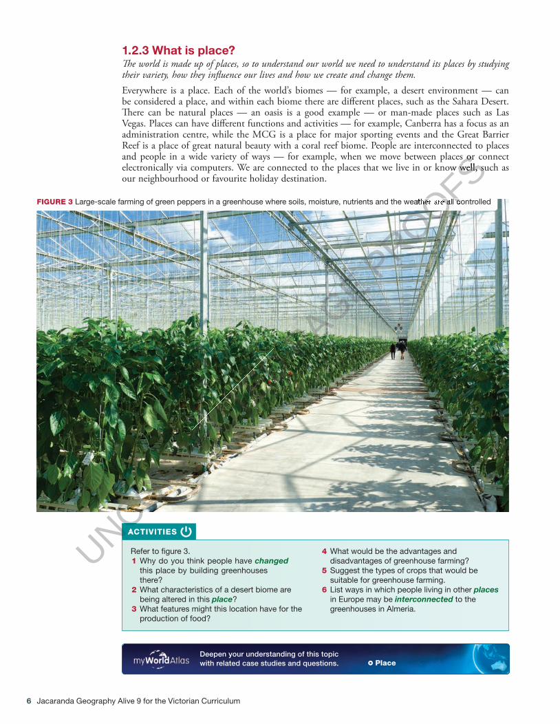
1.2.3 What is place? � e world is made up of places, so to understand our world we need to understand its places by studying their variety, how they in� uence our lives and how we create and change them. Everywhere is a place. Each of the world’s biomes — for example, a desert environment — can be considered a place, and within each biome there are di� erent places, such as the Sahara Desert. � ere can be natural places — an oasis is a good example — or man-made places such as Las Vegas. Places can have di� erent functions and activities — for example, Canberra has a focus as an administration centre, while the MCG is a place for major sporting events and the Great Barrier Reef is a place of great natural beauty with a coral reef biome. People are interconnected to places and people in a wide variety of ways — for example, when we move between places or connect electronically via computers. We are connected to the places that we live in or know well, such as our neighbourhood or favourite holiday destination.
FIGURE 3 Large-scale farming of green peppers in a greenhouse where soils, moisture, nutrients and the weather are all controlled
ACTIVITIES
Refer to � gure 3. 1 Why do you think people have changed
this place by building greenhouses there?
2 What characteristics of a desert biome are being altered in this place ?
3 What features might this location have for the production of food?
4 What would be the advantages and disadvantages of greenhouse farming?
5 Suggest the types of crops that would be suitable for greenhouse farming.
6 List ways in which people living in other places in Europe may be interconnected to the greenhouses in Almeria.
Deepen your understanding of this topic with related case studies and questions. � Place
c01TheWorldOfGeography.indd 6 27/10/16 7:56 PM
UNCORRECTED
UNCORRECTED
UNCORRECTED
ACTIVITIES
UNCORRECTED
ACTIVITIES
UNCORRECTED PAGE P
ROOFSand people in a wide variety of ways — for example, when we move between places or connect
PROOFSand people in a wide variety of ways — for example, when we move between places or connect electronically via computers. We are connected to the places that we live in or know well, such as
PROOFSelectronically via computers. We are connected to the places that we live in or know well, such as
PROOFS
PROOFSLarge-scale farming of green peppers in a greenhouse where soils, moisture, nutrients and the weather are all controlled
PROOFSLarge-scale farming of green peppers in a greenhouse where soils, moisture, nutrients and the weather are all controlled

Topic 1 The world of Geography 7
1.2.4 What is interconnection? People and things are connected to other people and things in their own and other places, and understanding these connections helps us to understand how and why places are changing. Individual geographical features can be interconnected — for example, the climate within a place or biome, such as a tropical rainforest, can in� uence natural vegetation, while removal of this vegetation can affect climate. People can be interconnected to other people and other places via employment, communications, sporting events or culturally. � e manufacturing of a product may create interconnections between suppliers, manufacturers, retail-ers and consumers.
ACTIVITIES
Refer to � gure 4. 1 Describe the distribution of the main ports
dealing with e-waste trade. 2 What is the interconnection between the main
recycling countries and the main ports that receive and dispatch e-waste?
3 Where are the destinations of e-wastes from Europe?
4 Describe the interconnection between North America and Asia in relation to e-waste trade.
5 Create a diagram to show the interconnections that could occur for the growing, manufacturing, sales and consumption of a can of pineapple slices.
Deepen your understanding of this topic with related case studies and questions. � Interconnection
1.2.5 What is change? � e concept of change is about using time to better understand a place, an environment, a spatial pattern or a geographical problem. From a geographical time perspective, change can be very slow — think of processes such as the formation of mountains or soil. On the other hand, a volcanic eruption or landslide can change
Tropic of Cancer
Equator
CHINA
INDIA
PAKISTAN
INDONESIA
JAPAN
SOUTHKOREA
MALAYSIA
AUSTRALIA
TAIWAN
SINGAPORE
Sher Shah
MacauMumbai
Seoul
HongKong
Karachi ShantouGuiyu
New Delhi
Chennai
NanhaiAhmedabad
Islamabad
Guangzhou
Beijing
Tokyo
I N D I A NO C E A N
PA C I F I CO C E A N
SOUTHCHINA
SEA
Bay ofBengal
fromEurope
from theArabian
Peninsulafrom North
America
KeyMain e-waste recyclingcountriesMovement of e-waste
E-waste recycling sitesKnownSuspectedMain ports where e-wasteis received and dispatched
0 1000 2000 km
Source: Spatial Vision
FIGURE 4 Many countries have strict laws dealing with e-waste disposal. It is often easier to export the material to countries in South-East Asia, where there are fewer laws and the wastes can be broken down, recycled or sold. It is extremely hazardous.
c01TheWorldOfGeography.indd 7 27/10/16 7:56 PM
UNCORRECTED
UNCORRECTED
UNCORRECTED
UNCORRECTED
UNCORRECTED
UNCORRECTED
UNCORRECTED
Describe the distribution of the main ports
UNCORRECTED
Describe the distribution of the main ports dealing with e-waste trade.
UNCORRECTED
dealing with e-waste trade. interconnection
UNCORRECTED
interconnection between the main
UNCORRECTED
between the main recycling countries and the main ports that
UNCORRECTED
recycling countries and the main ports that receive and dispatch e-waste?
UNCORRECTED
receive and dispatch e-waste? Where are the destinations of e-wastes
UNCORRECTED
Where are the destinations of e-wastes from Europe?
UNCORRECTED
from Europe?
UNCORRECTED
UNCORRECTED
UNCORRECTED
UNCORRECTED
UNCORRECTED
UNCORRECTED
UNCORRECTED
UNCORRECTED
UNCORRECTED Main ports where e-waste
UNCORRECTED Main ports where e-wasteis received and dispatched
UNCORRECTED is received and dispatched
Spatial Vision
UNCORRECTED Spatial Vision
PAGE
PAGE
PAGE
PAGE
PAGE
PAGE
PAGE
PAGE
PAGE
PAGE
PAGE
PAGE
PAGE
PAGE
PAGE
PAGE
PAGE
PAGE
PAGE
PAGE
PAGE
PAGE
PAGE
PAGE
PAGE
PAGE
PAGE
PAGE
PAGE
PAGE
PAGE
PAGE
PAGE
PAGE
PAGE
PAGE
PAGE
PAGE
PAGE
PAGE
PAGE MALAYSIA
PAGE MALAYSIAMALAYSIA
PAGE MALAYSIAMALAYSIA
PAGE MALAYSIA
SINGAPORE
PAGE SINGAPORESINGAPORE
PAGE SINGAPORESINGAPORE
PAGE SINGAPORESINGAPORE
PAGE SINGAPORESINGAPORE
PAGE SINGAPORE
I N D I A NPAGE I N D I A NO C E A NPAGE
O C E A NPAGE
PAGE
PAGE PROOFS
PROOFS
PROOFS
PROOFS
PROOFS
PROOFS
PROOFS
PROOFS
PROOFS
PROOFS
PROOFS
PROOFS
PROOFS
PROOFS
PROOFS
PROOFS
PROOFS
PROOFS
PROOFS
PROOFS
PROOFS
PROOFS
PROOFS
PROOFS
PROOFS
PROOFS
PROOFS
PROOFS
PROOFS
PROOFS
PROOFS
PROOFS
PROOFS
PROOFS
PROOFS
PROOFS
PROOFS
PROOFS
PROOFS
PROOFS
PROOFS
PROOFS
PROOFS
PROOFS
PROOFS
PROOFS
PROOFS
PROOFS
PROOFS
PROOFS
PROOFS
PROOFS
PROOFS
PROOFS
PROOFS
PROOFS
PROOFS
PROOFS
PROOFS
PROOFS
PROOFS
PROOFS
PROOFS
PROOFS
PROOFS
PROOFS
PROOFS
PROOFS
PROOFS
PROOFS
PROOFS
PROOFS
PROOFS
PROOFS
PROOFS
PROOFS
PROOFS
PROOFS
PROOFS
PROOFS
PROOFS
PROOFS
PROOFS
PROOFS
PROOFS
PROOFS
PROOFS
PROOFS
PROOFS
PROOFS
PROOFS
PROOFS
PROOFS
PROOFS
PROOFS
PROOFS
PROOFS
PROOFS
PROOFS
PROOFS
PROOFS
PROOFS
PROOFS
PROOFS
PROOFS
PROOFS
PROOFS
PROOFS
PROOFS
PROOFS
PROOFS
PROOFS
PROOFS
PROOFS
PROOFS
PROOFS
PROOFS
PROOFS
PROOFS
PROOFS
PROOFS
PROOFS
PROOFS
PROOFS
PROOFS
PROOFS
PROOFS
PROOFS
PROOFS
PROOFS
PROOFS
PROOFS
PROOFS
PROOFS
PROOFS
PROOFS
PROOFS
PROOFS
PROOFS
PROOFS
PROOFS
PROOFS
PROOFS
PROOFS
PROOFS
PROOFS
PROOFS
PROOFS
PROOFS
PROOFS
PROOFS
PROOFS
PROOFS
PROOFS
PROOFS
PROOFS
PROOFS
PROOFS
PROOFS
PROOFS
PROOFS
PROOFS
PROOFS
PROOFS
PROOFS
PROOFS
PROOFS
PROOFS
PROOFS
PROOFS
PROOFS
PROOFS
PROOFS
PROOFS
PROOFS
PROOFS
PROOFS
PROOFS
PROOFS
PROOFS
PROOFS
PROOFS
PROOFS
PROOFS
PROOFS
PROOFS
PROOFSKOREA
PROOFSKOREAKOREA
PROOFSKOREAKOREA
PROOFSKOREAKOREA
PROOFSKOREAKOREA
PROOFSKOREAKOREA
PROOFSKOREAKOREA
PROOFSKOREAKOREA
PROOFSKOREAKOREA
PROOFSKOREAKOREA
PROOFSKOREAKOREA
PROOFSKOREAKOREA
PROOFSKOREAKOREA
PROOFSKOREAKOREA
PROOFSKOREAKOREA
PROOFSKOREAKOREA
PROOFSKOREAKOREA
PROOFSKOREAKOREA
PROOFSKOREAKOREA
PROOFSKOREA
TAIWAN
PROOFSTAIWANTAIWAN
PROOFSTAIWANTAIWAN
PROOFSTAIWANTAIWAN
PROOFSTAIWANTAIWAN
PROOFSTAIWANTAIWAN
PROOFSTAIWANTAIWAN
PROOFSTAIWANTAIWAN
PROOFSTAIWANTAIWAN
PROOFSTAIWANTAIWAN
PROOFSTAIWANTAIWAN
PROOFSTAIWANTAIWAN
PROOFSTAIWAN
Macau
PROOFSMacauMacau
PROOFSMacauMacau
PROOFSMacau
Seoul
PROOFSSeoulSeoul
PROOFSSeoulSeoul
PROOFSSeoul
Hong
PROOFSHongHong
PROOFSHongHong
PROOFSHongKong
PROOFSKong
Shantou
PROOFSShantouShantou
PROOFSShantouShantou
PROOFSShantouShantou
PROOFSShantouShantou
PROOFSShantouShantou
PROOFSShantouShantou
PROOFSShantouShantou
PROOFSShantouShantou
PROOFSShantou
Guiyu
PROOFSGuiyuGuiyu
PROOFSGuiyuGuiyu
PROOFSGuiyuGuiyu
PROOFSGuiyu
SOUTH
PROOFSSOUTHCHINA
PROOFS
CHINA
8 Jacaranda Geography Alive 9 for the Victorian Curriculum
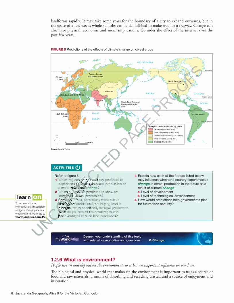
landforms rapidly. It may take some years for the boundary of a city to expand outwards, but in the space of a few weeks whole suburbs can be demolished to make way for a freeway. Change can also have physical, economic and social implications. Consider the e� ect of the internet over the past few years.
ACTIVITIES
Refer to � gure 5. 1 Which regions of the world are predicted to
experience decreases in cereal production as a result of climate change ?
2 Which regions are predicted to show an increase in cereal production?
3 Some countries, particularly those with a shortage of arable land, are buying land in other countries speci� cally for food production. What do you see as the advantages and disadvantages of such land purchases?
4 Explain how each of the factors listed below may in� uence whether a country experiences a change in cereal production in the future as a result of climate change .a Level of development b Level of technological advancement
5 How would predictions help governments plan for future food security? To access videos,
interactivities, discussion widgets, image galleries, weblinks and more, go to www.jacplus.com.au
Deepen your understanding of this topic with related case studies and questions. � Change
1.2.6 What is environment? People live in and depend on the environment, so it has an important in� uence on our lives. � e biological and physical world that makes up the environment is important to us as a source of food and raw materials, a means of absorbing and recycling wastes, and a source of enjoyment and inspiration.
Arctic Circle
Tropic of Cancer
Equator
Tropic of Capricorn
PACIFIC
ARCTIC OCEAN
ATLANTIC
OCEANOCEAN
INDIAN
OCEAN
North America
Latin America
South-East Asia andDeveloped Paci�cAsia
East Asia
Eastern Europeand former USSR
South Asia
WesternEurope
Middle East and North Africa
Sub-SaharanAfrica
Decrease (–8% to –19%)
Small decrease (1% to –10%)
Decrease or increase (–4% to 8%)
Small increase (2% to 4%)
Increase (1% to 20%)
Change in cereal production by 2060s
20000 4000 km
Source: Spatial Vision
FIGURE 5 Predictions of the effects of climate change on cereal crops
c01TheWorldOfGeography.indd 8 27/10/16 7:56 PM
UNCORRECTED
UNCORRECTED
Which regions of the world are predicted to
UNCORRECTED
Which regions of the world are predicted to experience decreases in cereal production as
UNCORRECTED
experience decreases in cereal production as a result of climate
UNCORRECTED
a result of climate change
UNCORRECTED
change Which regions are predicted to show an
UNCORRECTED
Which regions are predicted to show an increase in cereal production?
UNCORRECTED
increase in cereal production? Some countries, particularly those with a
UNCORRECTED
Some countries, particularly those with a shortage of arable land, are buying land in
UNCORRECTED
shortage of arable land, are buying land in other countries speci� cally for food production.
UNCORRECTED
other countries speci� cally for food production. What do you see as the advantages and
UNCORRECTED
What do you see as the advantages and disadvantages of such land purchases?
UNCORRECTED
disadvantages of such land purchases?
UNCORRECTED
UNCORRECTED
UNCORRECTED
www.jacplus.com.au
UNCORRECTED
www.jacplus.com.au
UNCORRECTED PAGE
PAGE
PAGE
PAGE
PAGE
PAGE
PAGE
PAGE
PAGE
PAGE
PAGE
PAGE
PAGE
PAGE
PAGE
PAGE
PAGE
PAGE
PAGE
PAGE
PAGE
PAGE
PAGE
PAGE
PAGE
PAGE
PAGE
PAGE
PAGE
PAGE
PAGE
PAGE
PAGE
PAGE
PAGE
PAGE
PAGE
PAGE
PAGE
PAGE
PAGE
PAGE
PAGE
PAGE
PAGE
PAGE
PAGE
PAGE
PAGE
PAGE
PAGE
PAGE
PAGE
PAGE
PAGE
PAGE
PAGE
PAGE
PAGE
PAGE
PAGE
PAGE
PAGE
PAGE
PAGE
PAGE
PAGE
PAGE
PAGE
PAGE
PAGE
PAGE
PAGE
PAGE
PAGE
PAGE Change in cereal production by 2060s
PAGE Change in cereal production by 2060s
PAGE PROOFS
PROOFS
PROOFS
PROOFS
PROOFS
PROOFS
PROOFS
PROOFS
PROOFS
PROOFS
PROOFS
PROOFS
PROOFS
PROOFS
PROOFS
PROOFS
PROOFS
PROOFS
PROOFS
PROOFS
PROOFS
PROOFS
PROOFS
PROOFS
PROOFS
PROOFS
PROOFS
PROOFS
PROOFS
PROOFS
PROOFS
PROOFS
PROOFS
PROOFS
PROOFS
PROOFS
PROOFS
PROOFS
PROOFS
PROOFS
PROOFS
PROOFS
PROOFS
PROOFS
PROOFS
PROOFS
PROOFS
PROOFS
PROOFS
PROOFS
PROOFS
PROOFS
PROOFS
PROOFS
PROOFS
PROOFS
PROOFS
PROOFS
PROOFS
PROOFS
PROOFS
PROOFS
PROOFS
PROOFS
PROOFS
PROOFS
PROOFS
PROOFS
PROOFS
PROOFS
PROOFS
PROOFS
PROOFS
PROOFS
PROOFS
PROOFS
PROOFS
PROOFS
PROOFS
PROOFS
PROOFS
PROOFS
PROOFS
PROOFS
PROOFS
PROOFS
PROOFS
OCEAN
PROOFS
OCEAN
North America
PROOFSNorth America
Topic 1 The world of Geography 9
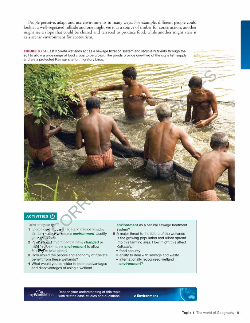
People perceive, adapt and use environments in many ways. For example, di� erent people could look at a well-vegetated hillside and one might see it as a source of timber for construction, another might see a slope that could be cleared and terraced to produce food, while another might view it as a scenic environment for ecotourism.
ACTIVITIES
Refer to � gure 6. 1 Look closely at the image and decide whether
this is a natural or human environment . Justify your decision.
2 In what ways might people have changed or modi� ed the natural environment to allow farming to take place?
3 How would the people and economy of Kolkata bene� t from these wetlands?
4 What would you consider to be the advantages and disadvantages of using a wetland
environment as a natural sewage treatment system?
5 A major threat to the future of the wetlands is the growing population and urban spread into this farming area. How might this affect Kolkata’s:• food security • ability to deal with sewage and waste • internationally recognised wetland
environment ?
Deepen your understanding of this topic with related case studies and questions. � Environment
FIGURE 6 The East Kolkata wetlands act as a sewage � ltration system and recycle nutrients through the soil to allow a wide range of food crops to be grown. The ponds provide one-third of the city’s � sh supply and are a protected Ramsar site for migratory birds.
c01TheWorldOfGeography.indd 9 27/10/16 7:56 PM
UNCORRECTED
UNCORRECTED
Refer to � gure 6.
UNCORRECTED
Refer to � gure 6. Look closely at the image and decide whether
UNCORRECTED
Look closely at the image and decide whether this is a natural or human
UNCORRECTED
this is a natural or human your decision.
UNCORRECTED
your decision. In what ways might people have UNCORRECTED
In what ways might people have modi� ed the natural UNCORRECTED
modi� ed the natural UNCORRECTED
farming to take place? UNCORRECTED
farming to take place? UNCORRECTED
UNCORRECTED PAGE P
ROOFS
10 Jacaranda Geography Alive 9 for the Victorian Curriculum
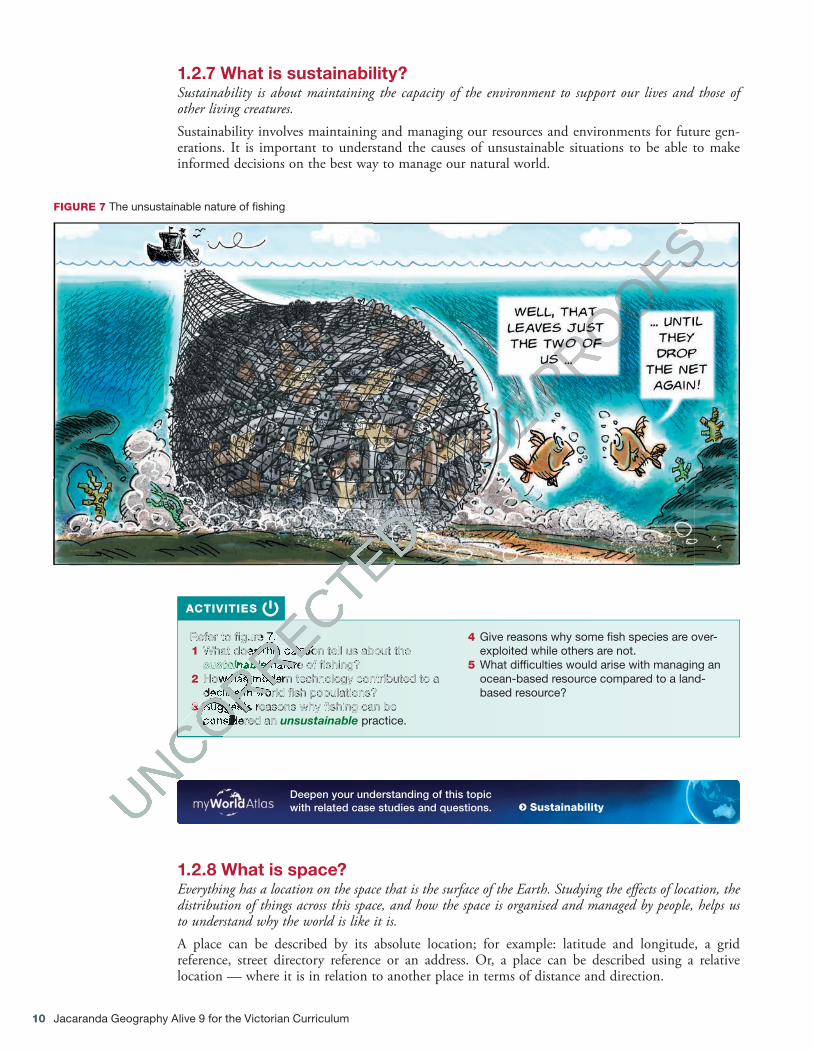
1.2.7 What is sustainability? Sustainability is about maintaining the capacity of the environment to support our lives and those of other living creatures. Sustainability involves maintaining and managing our resources and environments for future gen-erations. It is important to understand the causes of unsustainable situations to be able to make informed decisions on the best way to manage our natural world.
FIGURE 7 The unsustainable nature of � shing
ACTIVITIES
Refer to � gure 7. 1 What does this cartoon tell us about the
sustainable nature of � shing? 2 How has modern technology contributed to a
decline in world � sh populations? 3 Suggests reasons why � shing can be
considered an unsustainable practice.
4 Give reasons why some � sh species are over-exploited while others are not.
5 What dif� culties would arise with managing an ocean-based resource compared to a land-based resource?
Deepen your understanding of this topic with related case studies and questions.
� Sustainability
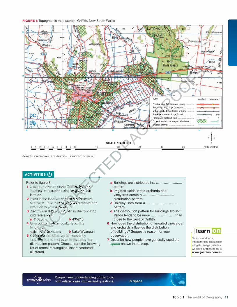
1.2.8 What is space? Everything has a location on the space that is the surface of the Earth. Studying the e� ects of location, the distribution of things across this space, and how the space is organised and managed by people, helps us to understand why the world is like it is. A place can be described by its absolute location; for example: latitude and longitude, a grid reference, street directory reference or an address. Or, a place can be described using a relative location — where it is in relation to another place in terms of distance and direction.
c01TheWorldOfGeography.indd 10 27/10/16 7:56 PM
UNCORRECTED
UNCORRECTED
UNCORRECTED
UNCORRECTED
UNCORRECTED
Refer to � gure 7.
UNCORRECTED
Refer to � gure 7. What does this cartoon tell us about the
UNCORRECTED
What does this cartoon tell us about the sustainable
UNCORRECTED
sustainable nature of � shing?
UNCORRECTED
nature of � shing? How has modern technology contributed to a
UNCORRECTED
How has modern technology contributed to a decline in world � sh populations?
UNCORRECTED
decline in world � sh populations? 3
UNCORRECTED
3 Suggests reasons why � shing can be
UNCORRECTED
Suggests reasons why � shing can be considered an
UNCORRECTED
considered an
UNCORRECTED
UNCORRECTED PAGE
PAGE PROOFS
PROOFS
Topic 1 The world of Geography 11
ACTIVITIES
Refer to � gure 8. 1 Use your atlas to locate Grif� th. Provide
its absolute location using longitude and latitude.
2 What is the location of Grif� th Aerodrome relative to Lake Wyangan? Use distance and direction in your answer.
3 Identify the features located at the following grid references.a 413208 b 435215
4 Give grid reference locations for the following.a Grif� th Aerodrome b Lake Wyangan
5 Complete the following sentences by inserting the correct term to describe the distribution pattern. Choose from the following list of terms: rectangular; linear; scattered; clustered.
a Buildings are distributed in a ………………...… pattern.
b Irrigated � elds in the orchards and vineyards create a ………………........… distribution pattern.
c Railway lines form a ………………........… pattern.
d The distribution pattern for buildings around Yenda tends to be more ………………… than those to the west of Grif� th.
6 How does the distribution of irrigated vineyards and orchards in� uence the distribution of buildings? Suggest a reason for your observation.
7 Describe how people have generally used the space shown in the map.
To access videos, interactivities, discussion widgets, image galleries, weblinks and more, go to www.jacplus.com.au
Deepen your understanding of this topic with related case studies and questions. � Space
20
40 41 42 43 44
21
22
Principal road; Built-up areas; Locality ...............
Secondary road; Bridge; Causeway ..................
Multiple track railway; Station or siding ............
Single track railway; Bridge, Tunnel ..................
Homestead; Building/s; Ruin ..............................
Orchard, plantation or vineyard; Windbreak ......
Irrigation channel .............................................
Key
SCALE 1:250 0000 1 2 3 4 5 6 7 8 9 10 20 25 30 35 40 kilometres15
Source: Commonwealth of Australia (Geoscience Australia).
FIGURE 8 Topographic map extract, Grif� th, New South Wales
Source: Commonwealth of Australia (Geoscience Australia)
c01TheWorldOfGeography.indd 11 27/10/16 7:56 PM
UNCORRECTED
UNCORRECTED
Use your atlas to locate Grif� th. Provide
UNCORRECTED
Use your atlas to locate Grif� th. Provide its absolute location using longitude and
UNCORRECTED
its absolute location using longitude and
What is the location of Grif� th Aerodrome
UNCORRECTED
What is the location of Grif� th Aerodrome relative to Lake Wyangan? Use distance and
UNCORRECTED
relative to Lake Wyangan? Use distance and direction in your answer.
UNCORRECTED
direction in your answer. Identify the features located at the following
UNCORRECTED
Identify the features located at the following grid references.
UNCORRECTED
grid references.413208
UNCORRECTED
413208 Give grid reference locations for the
UNCORRECTED
Give grid reference locations for the following.
UNCORRECTED
following.a UNCORRECTED
a Grif� th Aerodrome UNCORRECTED
Grif� th Aerodrome Complete the following sentences by UNCORRECTED
Complete the following sentences by inserting the correct term to describe the UNCORRECTED
inserting the correct term to describe the UNCORRECTED
UNCORRECTED
UNCORRECTED
UNCORRECTED PAGE
PAGE
PAGE
PAGE
PAGE
PAGE Homestead; Building/s; Ruin ..............................
PAGE Homestead; Building/s; Ruin ..............................
Orchard, plantation or vineyard; Windbreak ......
PAGE Orchard, plantation or vineyard; Windbreak ......
Irrigation channel .............................................
PAGE Irrigation channel .............................................
PAGE SCALE 1:250 000PAGE SCALE 1:250 000PAGE
PAGE PROOFS
PROOFSPrincipal road; Built-up areas; Locality ...............
PROOFSPrincipal road; Built-up areas; Locality ...............
Secondary road; Bridge; Causeway ..................
PROOFS
Secondary road; Bridge; Causeway ..................
Multiple track railway; Station or siding ............PROOFS
Multiple track railway; Station or siding ............
Single track railway; Bridge, Tunnel ..................PROOFS
Single track railway; Bridge, Tunnel ..................
Homestead; Building/s; Ruin ..............................PROOFS
Homestead; Building/s; Ruin ..............................PROOFS

12 Jacaranda Geography Alive 9 for the Victorian Curriculum
1.3 Review1.3.1 Applying the conceptsSaudi Arabia is home to extensive desert regions. Today, thanks to advances in technology, much of the desert is being transformed into productive farming areas. Fruits, vegetables and grains are the main crops grown, and these help to improve the country’s food security. Extensive drilling is tapping into underground aquifers as much as 1000 metres deep to access water for irrigation of water-hungry crops. Large circular sprays, called centre pivots, create a distinctive circular pattern of �elds (see �gure 1b).
Rainfall in the Wadi As-Sirhan Basin averages only 100–200 millimetres per year, which is insuf-�cient to recharge underground aquifers. �e water that is being pumped to the surface is actually ‘fossil’ water, possibly up to 20 000 years old. �e volume of water that is being used for desert agri-culture has more than tripled in just over 25 years.
100 20 km 100 20 km
FIGURE 1 Satellite images of the Wadi As-Sirhan Basin in Saudi Arabia. Note: Landsat imagery shows new vegetation as bright green, while dry vegetation or land lying fallow is shown as rust-coloured. Dry desert areas are shown as pink and yellow.
(b) 2012(a) 1987
c01TheWorldOfGeography.indd 12 27/10/16 7:56 PM
UNCORRECTED
UNCORRECTED
UNCORRECTED
UNCORRECTED
UNCORRECTED
UNCORRECTED
20 kmUNCORRECTED
20 km
PAGE PROOFS
water-hungry crops. Large circular sprays, called centre pivots, create a distinctive circular pattern
PROOFSwater-hungry crops. Large circular sprays, called centre pivots, create a distinctive circular pattern
Rainfall in the Wadi As-Sirhan Basin averages only 100–200 millimetres per year, which is insuf
PROOFSRainfall in the Wadi As-Sirhan Basin averages only 100–200 millimetres per year, which is insuf�cient to recharge underground aquifers. �e water that is being pumped to the surface is actually
PROOFS�cient to recharge underground aquifers. �e water that is being pumped to the surface is actually ears old. �e volume of water that is being used for desert agri
PROOFSears old. �e volume of water that is being used for desert agri
PROOFS
PROOFS Landsat imagery shows new vegetation as bright green,
PROOFS Landsat imagery shows new vegetation as bright green,
while dry vegetation or land lying fallow is shown as rust-coloured. Dry desert areas are shown as pink and yellow.PROOFS
while dry vegetation or land lying fallow is shown as rust-coloured. Dry desert areas are shown as pink and yellow.

Topic 1 The world of Geography 13
ACTIVITIES
1 Where is Saudi Arabia located? (space)2 Looking at �gure 1a, how would you describe
this place?3 What do you think the white lines to the north-
west of the image are? What does this tell you about the climate in this region? (environment, space)
4 Comparing the two images, describe the changes that irrigation has brought to this environment.
5 Each of the �elds in �gure 1b is approximately 1 kilometre wide. What does this indicate about the scale of this irrigation region?
6 How would the isolation of this irrigation region affect the movement of fresh produce to markets in cities? (interconnection)
7 Hydrologists (water engineers) believe that it will be economical to continue pumping water for only another 50 years. Is the use of groundwater sustainable in the future?
1.3.1 Applying the conceptsSaudi Arabia is home to extensive desert regions. Today, thanks to advances in technology, much of the desert is being transformed into productive farming areas. Fruits, vegetables and grains are the main crops grown, and these help to improve the country’s food security. Extensive drilling is tapping into underground aquifers as much as 1000 metres deep to access water for irrigation of water-hungry crops. Large circular sprays, called centre pivots, create a distinctive circular pattern of �elds (see �gure 1b).
Rainfall in the Wadi As-Sirhan Basin averages only 100–200 millimetres per year, which is insuf-�cient to recharge underground aquifers. �e water that is being pumped to the surface is actually ‘fossil’ water, possibly up to 20 000 years old. �e volume of water that is being used for desert agri-culture has more than tripled in just over 25 years.
100 20 km 100 20 km
FIGURE 1 Satellite images of the Wadi As-Sirhan Basin in Saudi Arabia. Note: Landsat imagery shows new vegetation as bright green, while dry vegetation or land lying fallow is shown as rust-coloured. Dry desert areas are shown as pink and yellow.
(b) 2012(a) 1987
c01TheWorldOfGeography.indd 13 27/10/16 7:56 PM
UNCORRECTED PAGE P
ROOFS