11 Effects on Hydrology - Transport Scotland
21
149 715/M8 MOTORWAY & GREENOCK ROAD (A8), INCHINNAN CASS ASSOCIATES ROYAL ORDNANCE, BISHOPTON MARCH 2015 11 Effects on Hydrology Introduction & Methodology Background 11.1 This chapter examines the potential impacts on hydrology for a proposed junction between the M8 Motorway and the A8 road near Bishopton, Renfrewshire. The proposed junction is designated M8 Jn29A. 11.2 A hydrological assessment of potential impacts of the road improvement including possible mitigation measures is now required as part of an Environmental Statement. Methodology and Significance Criteria General Scope of Assessment 11.3 The Scope of the Hydrological Assessment falls into a number of general categories that are incorporated into the overall Assessment Methodology; • Desktop review of available background data, available maps and published information as well as consultation with relevant statutory and non-statutory bodies. • Site walkover including establishment of local hydrology and water supplies as well as conducting interviews with local stakeholders. • Analysis of existing hydrology and establishment of Baseline Condition and its sensitivity. • Analysis of proposed road impact (likelihood and significance) on the local hydrology and the establishment of a risk matrix to guide potential mitigation measures. • Identification of measures to avoid and mitigate evaluated potential effects; • Reporting and summary of Construction Mitigation and Residual Effects. 11.4 Additional details of these elements are provided in the sections below. Relevant Guidance 11.5 The Planning context is set out in Chapter 5 of this statement. The hydrology assessment has been undertaken in line with the following regulations, policies and guidance: • Water Framework Directive (2000/60/EC) 30 . The Water Framework Directive (WFD) establishes a framework for the protection, improvement and sustainable use of all water environments; • The Environmental Impact Assessment (Scotland) Regulations 1999 – Part II (with amendments) • Scottish Environment Protection Agency, Policy No 41. • The Construction Industry Research and Information Association (CIRIA) C624 (2004) – ‘Development and Flood Risk – guidance for the construction industry’. • CIRIA C650 (2005) – ‘Environmental Good Practice on Site’. • CIRIA C532 (2001) – ‘Control of Water Pollution from Construction Sites’. 30 European Parliament (2000). “Directive 2000/60/EC of the European Parliament and of the Council establishing a framework for the Community action in the field of water policy” (“The Water Framework Directive”).
Transcript of 11 Effects on Hydrology - Transport Scotland

149
715/M8 MOTORWAY & GREENOCK ROAD (A8), INCHINNAN CASS ASSOCIATES ROYAL ORDNANCE, BISHOPTON MARCH 2015
11 Effects on Hydrology Introduction & Methodology
Background
11.1 This chapter examines the potential impacts on hydrology for a proposed junction between the M8 Motorway and the A8 road near Bishopton, Renfrewshire. The proposed junction is designated M8 Jn29A.
11.2 A hydrological assessment of potential impacts of the road improvement including possible mitigation measures is now required as part of an Environmental Statement.
Methodology and Significance Criteria
General Scope of Assessment
11.3 The Scope of the Hydrological Assessment falls into a number of general categories that are incorporated into the overall Assessment Methodology;
• Desktop review of available background data, available maps and published information as well as consultation with relevant statutory and non-statutory bodies.
• Site walkover including establishment of local hydrology and water supplies as well as conducting interviews with local stakeholders.
• Analysis of existing hydrology and establishment of Baseline Condition and its sensitivity.
• Analysis of proposed road impact (likelihood and significance) on the local hydrology and the establishment of a risk matrix to guide potential mitigation measures.
• Identification of measures to avoid and mitigate evaluated potential effects;
• Reporting and summary of Construction Mitigation and Residual Effects.
11.4 Additional details of these elements are provided in the sections below.
Relevant Guidance
11.5 The Planning context is set out in Chapter 5 of this statement. The hydrology assessment has been undertaken in line with the following regulations, policies and guidance:
• Water Framework Directive (2000/60/EC)30. The Water Framework Directive (WFD) establishes a framework for the protection, improvement and sustainable use of all water environments;
• The Environmental Impact Assessment (Scotland) Regulations 1999 – Part II (with amendments)
• Scottish Environment Protection Agency, Policy No 41.
• The Construction Industry Research and Information Association (CIRIA) C624 (2004) – ‘Development and Flood Risk – guidance for the construction industry’.
• CIRIA C650 (2005) – ‘Environmental Good Practice on Site’.
• CIRIA C532 (2001) – ‘Control of Water Pollution from Construction Sites’.
30 European Parliament (2000). “Directive 2000/60/EC of the European Parliament and of the Council establishing a framework for the Community action in the field of water policy” (“The Water Framework Directive”).

150
715/M8 MOTORWAY & GREENOCK ROAD (A8), INCHINNAN CASS ASSOCIATES ROYAL ORDNANCE, BISHOPTON MARCH 2015
• CIRIA C697 (2007) SUDS Manual
• Scottish Planning Policy (SPP) (February 2010) – Scottish Government policy on nationally important land use planning matters.
• PPG1 ‘General guide to the prevention of water pollution’
• PPG5 ‘Works in, near or liable to affect watercourses’
• PPG6 – Working at construction and demolition sites
• PPG7 – Refuelling facilities
Assessment Area
11.6 This assessment only addresses the effects of the proposed new M8Jn29A road junction near Bishopton as detailed elsewhere in the Environmental Statement. The description of the hydrological baseline considers the area at the proposed junction together with the land in the immediate vicinity including that of the local residents.
Consultations & Background Information
11.7 Information has been provided by a range of organisations and individuals during the assessment as summarised in the table below.
Table 11.1: Consultations
Consultee Notes
SEPA Telephone discussions with area staff. Awaiting response to written enquiry.
The Meteorological Office Information obtained on meteorological conditions and regional climate averages.
Local Residents
Discussions were held with a key land owner whose land is directly affected by the proposed junction in November 2012. Details of these interviews are discussed and addressed within the assessment.
11.8 Additional information was provided by previously issued land assessments including;
• Terrenus Consulting - Site Investigation Report – issued October 2006
• Dougall Baillie Associates - Flood Risk and Surface Water Drainage Impact Assessment Report (Rev A) – issued August 2006
• BAE Systems Environmental – Environmental Statement – issued October 2012
11.9 Proposed Sustainable Drainage System design layout details relating to the current junction development proposal were provided by Dougall Baillie Associates.
Desk Study
11.10 The desk study collated existing data to form an understanding of the hydrology and hydrogeology of the area.

151
715/M8 MOTORWAY & GREENOCK ROAD (A8), INCHINNAN CASS ASSOCIATES ROYAL ORDNANCE, BISHOPTON MARCH 2015
11.11 The desk study included:
• An overview of the local catchment including watercourses, drainage patterns and water features;
• Collation of data provided through consultations, and
• Compilation of soils, geological and hydrogeological information
11.12 Reference was made to the following sources of information:
• The British Geological Survey (BGS) Digital Mapping
• Hydrogeological Map of Scotland, 1988. British Geological Survey
• Groundwater Vulnerability Map of Scotland, 1995. British Geological Survey
• Publically available Ordnance Survey (OS) sheets
• Topographic survey supplied by Dougall Baillie Associates
Site Walkover
11.13 A site walkover was carried out on 20th November 2012 to inspect surface water features, obtain an understanding of the local topography and hydrological regime, and to interview a number of local residents.
Significance Criteria
11.14 The following criterion is used throughout this assessment:
The significance of the potential effects of the proposed road junction are classified by taking into account the sensitivity of receptors and the magnitude of the potential effect, combined with the likelihood of an event occurring.
11.15 The Town and Country Planning (Environmental Impact Assessment) (Scotland) Regulations requires a description of:
(a) The magnitude and complexity of the impact
(b) The probability of the impact
(c) The duration, frequency and reversibility of the impact.
11.16 The assessment is based on a ‘significance matrix assessment approach’ which in turn is based on the characteristics of the impact (magnitude and nature) and the sensitivity of the receptor. This relies on the importance attached to the receptor (or indicator) in local, regional and national economic development and regeneration policy in the study team’s professional judgement.
11.17 The EIA assessment method presented herein for impacts not relating to contamination is based on impact assessment guidance which can be found in:
11.18 Design Manual for Roads and Bridges, Volume 11 Environmental Assessment, Section 2, Part 5, HA205/08 Assessment And Management Of Environmental Effects (Highways Agency et al, 2008).
11.19 DMRB guidance information relevant to the Hydrogeology / Water Environment is found in the following related documents.
11.20 Design Manual for Roads and Bridges, Volume 11 Environmental Assessment, Section 3, Part 11, Geology and Soils (Highways Agency et al, 1993).

152
715/M8 MOTORWAY & GREENOCK ROAD (A8), INCHINNAN CASS ASSOCIATES ROYAL ORDNANCE, BISHOPTON MARCH 2015
11.21 Design Manual for Roads and Bridges, Volume 11 Environmental Assessment, Section 3, Part 10, HD 45/09 Road Drainage and the Water Environment (Highways Agency et al, 2008).
11.22 The EIA Regulations require consideration of a variety of types of effect, namely:
• Direct/indirect
• Secondary
• Cumulative
• Positive/negative
• Short/medium/long-term; and
• Permanent/temporary.
11.23 In this ES, effects are considered in terms of how they arise, whether they are positive or negative, and their duration. Each will have a source originating from the development, a pathway and a receptor. Table 11.2 defines the relative terms used in describing the nature of effects.
Table11.2: Definitions of the terms used in describing the nature of effects
Effect Description
Direct Effects arising on-site
Indirect Effects arising off-site due to the proposed development.
Temporary Effects which cause a change to the baseline for a limited period of time.
Permanent Effects causing an irreversible change to the baseline.
Short-term Impact is measurable over seconds up to 3 months’ time
Medium-term Impact is measurable over 4 months to 2 years’ time
Long-term Impact is measurable greater than 3 years
Cumulative Effects which arise from multiple types of effect on a particular receptor. These may overlap spatially or temporally.
11.24 The assessment of the potentially significant environmental effects has been based on a set of sensitivity criteria. For the purpose of this assessment sensitivity is determined as Very High, High, Medium, Low and Negligible.
11.25 Examples of how sensitivity may be determined for a particular feature are provided for transparency. The example hydrogeological criteria have been taken from guidance (DMRB, Volume 11 Environmental Assessment, Section 3, Part 10, HD 45/09 Road Drainage and the Water Environment, Highways Agency, 2009). Other receptors’ sensitivities have been produced for receptors where no descriptive examples are provided in the DMRB guidance.

153
715/M8 MOTORWAY & GREENOCK ROAD (A8), INCHINNAN CASS ASSOCIATES ROYAL ORDNANCE, BISHOPTON MARCH 2015
Unmitigated Development Sensitivity
11.26 Sensitivity is also dependent on factors such as the quality of local receiving waters and their existing purpose and influences. In this instance the local surface receiving waters comprise drainage channels that discharge into the Wheel and then the Lin Burn which are not at present officially monitored.
11.27 The infiltration to deep groundwater is considered to be limited due to the type of superficial deposits in the area; furthermore the level of ground water abstraction in the area is very limited.
11.28 The magnitude includes the timing, scale, size and duration of the potential effect resulting from the proposed development. Table 11.3 provides a ranking and example criteria.
Table 11.3: Methodology for Assessing Sensitivity of Hydrogeology Receptors:
Sensitivity Criteria Example Criteria
Very High Attribute has a high quality and/or rarity on local scale
Groundwater aquifers currently used, or likely to be suitable for use as public potable supplies (e.g. Principal Aquifers, Source Protection Zone for a potable groundwater supply).
Groundwater that is providing baseflow to ‘very good’ WFD status quality surface water.
High Attribute has a high quality and/or rarity on local scale
Groundwater aquifers currently used for, or likely to be suitable for, providing non-potable supplies or limited domestic supplies (e.g. Secondary Aquifers for domestic supplies or industrial abstractions).
Groundwater that is providing baseflow to ‘good’ WFD quality status surface water.
Medium Attribute has a medium quality and/or rarity on local scale
Groundwater that is unlikely to be suitable for providing abstractions (e.g. aquifers in areas of saline intrusion).
Low Attribute has a low quality and/or rarity on local scale.
Non-sensitive water resources (non-classified, static groundwater).
Negligible Attribute has a very low importance and/or rarity on local scale.
Non-aquifer such as Mudstone or Glacial Till which may contain very small amounts of groundwater.
Determining the magnitude of impacts
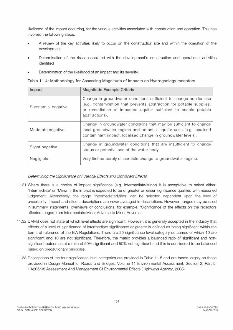
11.29 The magnitude of potential impacts on geology, soils, land use, hydrogeological features during both construction and operation of the proposed development has been assessed using the criteria presented in Table 11.4. The magnitude (scale of change) is determined by considering the degree of deviation from the baseline conditions and whether this is likely to result in any changes in the use of the receptor concerned.
11.30 In determining the scale of impacts some consideration has to be made regarding the likelihood of impact occurring under normal operating conditions. Where accidental events could arise but are of a very low likelihood, this is clearly stated. Impact magnitude has been determined by applying a qualitative conceptual model approach. This requires the identification of a source of impact, pathway to the receptor and the
154
715/M8 MOTORWAY & GREENOCK ROAD (A8), INCHINNAN CASS ASSOCIATES ROYAL ORDNANCE, BISHOPTON MARCH 2015
likelihood of the impact occurring, for the various activities associated with construction and operation. This has involved the following steps:
• A review of the key activities likely to occur on the construction site and within the operation of the development
• Determination of the risks associated with the development’s construction and operational activities identified
• Determination of the likelihood of an impact and its severity.
Table 11.4: Methodology for Assessing Magnitude of Impacts on Hydrogeology receptors
Impact Magnitude Example Criteria
Substantial negative
Change in groundwater conditions sufficient to change aquifer use (e.g. contamination that prevents abstraction for potable supplies, or remediation of impacted aquifer sufficient to enable potable abstractions).
Moderate negative Change in groundwater conditions that may be sufficient to change local groundwater regime and potential aquifer uses (e.g. localised contaminant impact, localised change in groundwater levels).
Slight negative Change in groundwater conditions that are insufficient to change status or potential use of the water body.
Negligible Very limited barely discernible change to groundwater regime.
Determining the Significance of Potential Effects and Significant Effects
11.31 Where there is a choice of impact significance (e.g. Intermediate/Minor) it is acceptable to select either: ‘Intermediate’ or ‘Minor’ if the impact is expected to be of greater or lesser significance qualified with reasoned judgement. Alternatively, the range ‘Intermediate/Minor’ can be selected dependent upon the level of uncertainty. Impact and effects descriptions are never averaged in descriptions. However, ranges may be used in summary statements, overviews or conclusions, for example, ‘Significance of the effects on the receptors affected ranged from Intermediate/Minor Adverse to Minor Adverse’.
11.32 DMRB does not state at which level effects are significant. However, it is generally accepted in the industry that effects of a level of significance of intermediate significance or greater is defined as being significant within the terms of reference of the EIA Regulations. There are 20 significance level category outcomes of which 10 are significant and 10 are not significant. Therefore, the matrix provides a balanced ratio of significant and non-significant outcomes at a ratio of 50% significant and 50% not significant and this is considered to be balanced based on precautionary principles.
11.33 Descriptions of the four significance level categories are provided in Table 11.5 and are based largely on those provided in Design Manual for Roads and Bridges, Volume 11 Environmental Assessment, Section 2, Part 5, HA205/08 Assessment And Management Of Environmental Effects (Highways Agency, 2008).

155
715/M8 MOTORWAY & GREENOCK ROAD (A8), INCHINNAN CASS ASSOCIATES ROYAL ORDNANCE, BISHOPTON MARCH 2015
Table 11.5: Estimating the Significance Level of Potential Effects on the Water Environment
Magnitude of Impact
Substantial Moderate Slight Negligible
Sen
sitiv
ity o
f R
ecep
tor
Very High Major Major Major to Intermediate
Intermediate to Minor
High Major Major to Intermediate
Intermediate to Minor
Minor
Medium Major to Intermediate
Intermediate to Minor
Minor Minor to Neutral
Low Intermediate to Minor
Minor Minor to Neutral
Minor to Neutral
Negligible Minor Minor to Neutral
Minor to Neutral
Neutral
Table 11.6: Level of Significance Criteria Descriptions for Water Environment
Significance Category Definition
Major(Significant)
These effects will represent the critical factors in the decision-making process (along with other topic effects in a similar category).
These effects are generally associated with sites or features that are of high quality and rarity on a regional or national scale that are likely to suffer a most damaging impact and loss of resource integrity.
These effects are generally associated with potential for either major impact magnitude on features of very high, high or medium importance; or moderate impact magnitude on features of very high or high importance. This is where the proposal would result in degradation of the water environment because it results in predicted very significant adverse effect on at least one attribute.
Major effects can potentially arise due to a number of less significant effects resulting in a larger cumulative effect.
Intermediate (Significant)
Due to the scale of the change predicted on features these effects can be considered to be important and material in the decision-making process, but are not likely to be critical or very important decision-making factors.
These effects are generally associated with potential for major impact magnitudes on features of low importance; or moderate impact magnitude on features of high or medium

156
715/M8 MOTORWAY & GREENOCK ROAD (A8), INCHINNAN CASS ASSOCIATES ROYAL ORDNANCE, BISHOPTON MARCH 2015
importance; or minor impact magnitude on features of very high or high importance.
This is generally where the proposal may result in the degradation of the water environment because it results in predicted moderate adverse effect on at least one attribute.
Moderate effects can potentially arise due to a number of less significant effects resulting in a larger cumulative effect.
Minor (Not Significant)
Effects at this level are of limited importance and immaterial in the decision-making in the decision-making process.
This is where the proposal may result in a degradation of the water environment because it potentially will results in a slight effect on one or more attributes.
Neutral (Not Significant)
No change in the baseline condition.
This means effects are beneath levels of scientific detection or human concern/perception, or are detectable / perceived within the normal bounds of natural variation.
Where the impact of the proposal is neutral, because it results in no appreciable effect, either positive or negative, on the identified attribute.
Neutral effects can arise where consented discharges operate within consented parameters.
Mitigated Development Risk
11.34 The residual significance after the development and implementation of mitigation measures is a function of the unmitigated significance combined with the likelihood of an event occurring with mitigation in place. The table below outlines this methodology. In line with the precautionary principle all significant unmitigated risks are assessed as being likely to occur.
Table 11.7: Significance on mitigated effects
Likelihood
Unmitigated Significance
Likely Possible Unlikely
Major Major Moderate Minor
Intermediate Moderate Minor Insignificant
Minor Minor Insignificant Insignificant
Neutral Insignificant Insignificant Insignificant

157
715/M8 MOTORWAY & GREENOCK ROAD (A8), INCHINNAN CASS ASSOCIATES ROYAL ORDNANCE, BISHOPTON MARCH 2015
11.35 The conclusions of this Chapter state whether residual significance is categorised as being major, moderate, minor or insignificant, once appropriate mitigation has been implemented. This assessment relies on professional judgment to ensure that the effects are appropriately assessed. Effects of moderate or major significance (as shaded above) are considered to be of significant concern in terms of the EIA Regulations31.
Information
11.36 Information gained during telephone conversations has been included in this assessment.
11.37 Sufficient data considered necessary to identify and assess the potential significant effects resulting from the development was available and used in the assessment reported in this Chapter.
Baseline Description
Topography & Land Use
11.38 The site is located on the M8 motorway about 1 kilometre south of the existing Junction 30 and about 13 kilometres north west of Glasgow City Centre. The M8 is approximately at grade at this location with the A8 crossing the carriageway supported by a bridge and the associated approach embankments. The National Grid Reference for the approximate site centre is NS 4500 6930.
11.39 The land use local to the western part of the proposed junction comprises agricultural land lying over a closed landfill which forms a hill feature rising to the west. Reed beds are located immediately to the west of the M8 and comprise shallow flooded areas. The reed beds are used to facilitate bioremediation of surface water emanating from the closed landfill to the west. The general topography over this section comprises the relatively flat ground associated with the reed beds and the slope of the adjacent landfill site to the west.
11.40 The land occupied by the reed beds lies at a level of about 8-8.5mOD and extends about 50 metres west of the M8 carriageway. The existing road embankment supporting the A8 crossing rises from about 10mOD at the toe to 15mOD at the carriageway edge at a slope gradient of about 1:2.5. The height of this embankment gradually decreases in a westerly direction.
11.41 The land use local to the eastern part of the proposed junction consists of agricultural grassland which is bound to the west and south by the M8 eastbound carriageway and to the north by the A8. The topography rises gently from the M8 carriageway at about 7.5mOD to approximately 9mOD at the toe of the low embankment supporting the A8. The A8 road at this point lies at a level of about 11.5mOD.
Superficial Geology
11.42 The superficial deposits beneath the site are recorded to consist principally of raised marine clay and silt overlying glacial till. Made ground comprising man-made materials deposited on the original ground surface are recorded in the vicinity of the proposed off-ramp. Full details of the local superficial geology are contained in the Chapter 13 Geology and Soils. Note that infiltration of the natural superficial deposits is likely to be low and that no exceedences of the human health assessment criteria were found during the site investigation.
11.43 Site investigations in the vicinity of the Southbar Landfill to consider the possibility of leachate adversely affecting the groundwater identified elevated Arsenic and Selenium. Recent (2014) ground investigations carried out for the south bound on-ramp indicate that thin deposits of made ground were present comprising topsoil mixed with some discarded artificial materials. Groundwater was noted to be at 2.00m depth or greater. No elevated contaminants were identified during the chemical testing.
31 The Environmental Impact Assessment (Scotland) Regulations 1999 available online at www.opsi.gov.uk/legislation/scotland/ssi1999/19990001.htm

158
715/M8 MOTORWAY & GREENOCK ROAD (A8), INCHINNAN CASS ASSOCIATES ROYAL ORDNANCE, BISHOPTON MARCH 2015
Solid Geology
11.44 The underlying solid geology comprises strata representative of the Limestone Coal and Lower Limestone Formations both of Carboniferous age. Full details of the local superficial geology are contained in the Chapter 12 Geology and Soils.
Contaminated Land
11.45 Southbarr Landfill lies adjacent to the proposed off-ramp section and is now closed and was restored to agricultural land in 2003. The landfill operated under licence from February 1981 and received over 500,000 tonnes of waste split over several phases. The authorised materials consisted principally of demolition wastes.
11.46 A number of reed beds / lagoons are present to the east of the landfill and adjacent to the M8 motorway. These features involve the treatment of surface water from the landfill and support the local ecology.
11.47 Details of the soil types and soil condition relating to the reed beds are contained in Chapter 12 of this Statement.
Climate
11.48 The Flood Estimation Handbook (FEH) dataset Version 3.0 records the Standard Average Annual Rainfall (SAAR) for the area to be in the order of 1108mm.
11.49 The Meteorological Office reports regional Average Annual Rainfall (AAR) for the assessment area (Paisley) to be 1205mm (1971 to 2000 period) and 1245mm (1981 to 2010).
Rainfall Runoff
11.50 Dougall Baillie Associates provides a detailed drainage design for the site including an assessment of existing and post development rainfall runoff. The calculators adopted by Dougall Baillie Associates for assessment of routine runoff comprise the IHR 124, FEH Rainfall Runoff and the ReFH methodologies. The SuDS analysis concludes that a 1 in 2 yr greenfield runoff rate of 8l/s/ha is appropriate for the site and forms the basis for post development runoff control.
Hydrogeology
11.51 The coastal and river alluvial deposits beneath the site are classified as a concealed aquifer of limited or local potential. The underlying bedrock may be considered moderately permeable.
11.52 Given the nature of the assessment area geology the local groundwater is likely to lie within the superficial deposits and may not be in direct continuity with the surface water regime.
11.53 SEPA defines the groundwater in the area (in the superficial and bedrock deposits) as having a poor chemistry. The groundwater 2008 classification status is defined as being Good and Poor according to the B7 and B8 assessments respectively. SEPA also notes that the groundwater is defined as a drinking water protection zone.
11.54 There are no current agreed or projected measures in place concerning ground water diffuse source pollution mitigation measures. No mitigation measures are currently in place concerning abstraction control of point source pollution.
11.55 Chemical testing of the local groundwater was carried out by BAE Systems Environmental with the report concluding that groundwater in the vicinity of the landfill contained some metals, free cyanide, PAHs and some SVOCs,. Elevated concentrations of ammonia were detected in all groundwater samples and are thought to originate from the naturally occurring superficial deposits based on the conditions encountered. From the data obtained, it was considered that the site is currently having a negligible effect on the water environment. Full

159
715/M8 MOTORWAY & GREENOCK ROAD (A8), INCHINNAN CASS ASSOCIATES ROYAL ORDNANCE, BISHOPTON MARCH 2015
details of the local ground water chemistry are provided in the BAE Systems Environmental report for the proposed scheme. (Appendices 12.1 and 12.2).
Hydrology and Drainage
11.56 The Scottish Environment Protection Agency (SEPA) provides as a public service a River Basin Management Plan Interactive Map. This resource provides information relating to the environmental status of a number of water bodies in the assessment area.
11.57 The land below the proposed junction lies just to the south east of the natural watershed between runoff flowing to the north west and the Craigton Burn and runoff flowing to the south east and the Lin Burn.
11.58 In general the area drains via a number of natural, agricultural and civil engineering related drains to the south and east. The surface water drainage features are fed by agricultural land drainage systems which converge to the south of the proposed junction to form the Wheel Burn. Some 900m downstream of the site the Wheel Burn discharges to the Lin Burn and thereafter to the River Gryfe, which in turn is a tributary to the Black Cart Water, and ultimately the River Clyde. The flood risk assessment considers it is likely that existing runoff from the surrounding farmland will discharge to the nearest drainage ditch and ultimately the Lin Burn
11.59 Full details of the local drainage patterns are contained within the Dougall Baillie Associates Flood Risk and Surface Water Drainage Impact Assessment Report. (Appendix 11.1).
11.60 Details of the local fauna and flora in relating to the ponded water system close to the site are contained in Chapter 9 of this Statement.
11.61 The nearest classified watercourse is Dargavel Burn which is a tributary of the River Gryfe and is located approximately 1 kilometre south west of the junction. The Dargavel Burn is classified as having a poor ecological status and poor objectives by 2015, however it should be noted that the runoff from the site does not directly connect with this watercourse.
11.62 Further downstream the River Gryfe and Clyde Estuary are classified as having a moderate status with both water courses having a transitional status of moderate ecological status and both being heavily modified.
11.63 Surface water bodies including local watercourses and ponds do not form part of a Drinking Water Protection Area.
Table 11.8: Importance of Surface Water Receptors
Receptor Attributes Importance
Groundwater No nearby abstractions. Little likelihood of future abstractions. Category 2 vulnerability with some contamination from landfill
Low
Lin Burn No nearby abstraction. Drains local farmland and connects with River Gryffe which is designated a SSSI
Moderate
Drainage Channels at Landfill
Directly connected with nearby Southbar landfill. Samples noted to contain metals
Low
Drainage Channels Facilitates local farmland drainage and likely to be affected by agricultural
Low

160
715/M8 MOTORWAY & GREENOCK ROAD (A8), INCHINNAN CASS ASSOCIATES ROYAL ORDNANCE, BISHOPTON MARCH 2015
runoff
Reed Beds Treats Southbar landfill runoff with some ecological life.
Moderate
Flooding
11.64 SEPA’s new Flood Map (Scotland) 200-year outline (i.e. the flood with a 0.5% chance of occurring in any single year) does not show fluvial flooding in the area of the proposed junction. This may be due to the small size of the local catchment.
11.65 The 200-year flood map should be treated with caution and SEPA make the following general comment:
“It (the flood map) does not provide enough detail to accurately estimate the flood risk associated with individual properties or specific point locations. Local factors such as flood defence schemes, structures in or around river channels such as bridges, buildings and other local influences, which might affect a flood, have not been included”.
11.66 The Dougall Baillie Associates Flood Risk And Surface Water Drainage Impact Assessment Report concludes that site is at little or no flood risk from fluvial flooding or flooding from groundwater. (Appendix 11.1).
Water Supplies
11.67 Scottish Water indicates that there is no mains water supply in the vicinity of the proposed new road; however consultation with local residents indicates that farms local to the site are supplied by mains water supplies.
Areas of Sensitivity
11.68 There are no areas local to the site that are defined by SEPA to be vulnerable to hydrological regime or water quality. There are no known abstractions of ground water in the vicinity of the site.
11.69 A Site of Importance for Nature Conservation (SINC) lies immediately to the south of the Southbar Landfill ponds on the western side of the M8. It is known that a drainage ditch separates the SINC from the proposed engineering works to the north.
11.70 The River Clyde and elements of the Black Cart Water downstream of the confluence with the River Gryfe are defined by Scottish Natural Heritage as both Special Protection Areas and Sites of Special Scientific Interest. The nearest of these areas is over 8km from the site and therefore unlikely to affected by the site.
11.71 Salmonid fresh water fish are known on the River Gryffe; however this designation lies upstream of the confluence with the Dargavel Burn and will not be affected by the site.
Assessment of Potential Effects
11.72 The effect of the proposed new junction on the water environment has been considered for the construction and operational phases of the development.
Description of Development Activities
11.73 Details of the construction activities for the proposed new road are described in the Project Description of the Environmental Statement. Development activities that could give rise to potentially significant hydrological and hydrogeological effects are listed below:
• Effect of development on local water courses;

161
715/M8 MOTORWAY & GREENOCK ROAD (A8), INCHINNAN CASS ASSOCIATES ROYAL ORDNANCE, BISHOPTON MARCH 2015
• Construction activities and site compound;
• Earthworks related to road preparation;
• Rainfall runoff during construction;
• Effectiveness of watercourse crossings and drainage features.
Receptors
11.74 The hydrology receptors at the site comprise the following:
• Local surface water drainage channels;
• Local drainage pipes;
• Locally designated SINC; and,
• Groundwater.
11.75 A number of sites of importance for nature conservation (SINCs) lie around the Bishopton area. The closest site to the proposed new junction lies immediately to the south of the Southbar Landfill ponds on the western side of the current motorway.
Sensitivity of Receptors
11.76 Due to the site location and local geology an assessment of the groundwater regime may be included within the surface water assessment.
11.77 A number of watercourses and drainage features pass across the line of the existing road network and will be affected by the proposed new junction. These watercourses generally carry water to the south and south east towards the Lin Burn and hence the River Gryfe.
11.78 There is a potential pathway for pollutants and sediment to enter these watercourses (and the wider hydrological network) through direct contact as well as via infiltration.
11.79 The sensitivities of the components within the water environment and their relationships to the potential effects from the development have been identified and are outlined below;
Table 11.9: Water Environment Sensitivities
Receptor Potential Effects Sensitivity of Receptor
Groundwater Pollution as a result of spillages during road construction and due to ongoing runoff.
Moderate
Watercourses & Local Drainage Network
Increased run-off, erosion and sedimentation, burn flow impediments and pollution as a result of road construction.
Moderate / High
Existing Road Drainage Systems
Effect of increased runoff on the existing A8 drainage system.
Moderate
162
715/M8 MOTORWAY & GREENOCK ROAD (A8), INCHINNAN CASS ASSOCIATES ROYAL ORDNANCE, BISHOPTON MARCH 2015
Local SINC to south of proposed junction
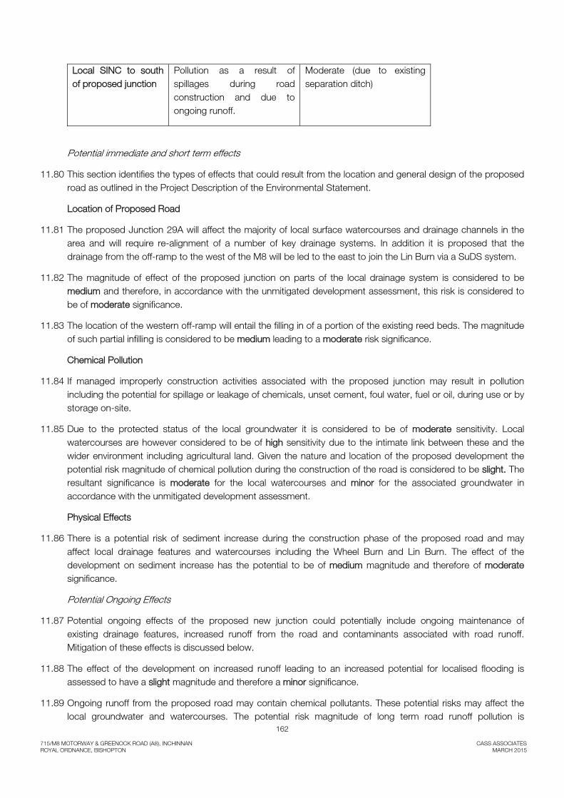
Pollution as a result of spillages during road construction and due to ongoing runoff.
Moderate (due to existing separation ditch)
Potential immediate and short term effects
11.80 This section identifies the types of effects that could result from the location and general design of the proposed road as outlined in the Project Description of the Environmental Statement.
Location of Proposed Road
11.81 The proposed Junction 29A will affect the majority of local surface watercourses and drainage channels in the area and will require re-alignment of a number of key drainage systems. In addition it is proposed that the drainage from the off-ramp to the west of the M8 will be led to the east to join the Lin Burn via a SuDS system.
11.82 The magnitude of effect of the proposed junction on parts of the local drainage system is considered to be medium and therefore, in accordance with the unmitigated development assessment, this risk is considered to be of moderate significance.
11.83 The location of the western off-ramp will entail the filling in of a portion of the existing reed beds. The magnitude of such partial infilling is considered to be medium leading to a moderate risk significance.
Chemical Pollution
11.84 If managed improperly construction activities associated with the proposed junction may result in pollution including the potential for spillage or leakage of chemicals, unset cement, foul water, fuel or oil, during use or by storage on-site.
11.85 Due to the protected status of the local groundwater it is considered to be of moderate sensitivity. Local watercourses are however considered to be of high sensitivity due to the intimate link between these and the wider environment including agricultural land. Given the nature and location of the proposed development the potential risk magnitude of chemical pollution during the construction of the road is considered to be slight. The resultant significance is moderate for the local watercourses and minor for the associated groundwater in accordance with the unmitigated development assessment.
Physical Effects
11.86 There is a potential risk of sediment increase during the construction phase of the proposed road and may affect local drainage features and watercourses including the Wheel Burn and Lin Burn. The effect of the development on sediment increase has the potential to be of medium magnitude and therefore of moderate significance.
Potential Ongoing Effects
11.87 Potential ongoing effects of the proposed new junction could potentially include ongoing maintenance of existing drainage features, increased runoff from the road and contaminants associated with road runoff. Mitigation of these effects is discussed below.
11.88 The effect of the development on increased runoff leading to an increased potential for localised flooding is assessed to have a slight magnitude and therefore a minor significance.
11.89 Ongoing runoff from the proposed road may contain chemical pollutants. These potential risks may affect the local groundwater and watercourses. The potential risk magnitude of long term road runoff pollution is

163
715/M8 MOTORWAY & GREENOCK ROAD (A8), INCHINNAN CASS ASSOCIATES ROYAL ORDNANCE, BISHOPTON MARCH 2015
considered to be medium. The resultant significance is moderate for the local watercourses in accordance with the unmitigated development assessment.
Mitigation Measures
11.90 Mitigation measures are broadly divided into those that will be “embedded” into the road design and those that will be implemented through good practice.
Embedded Mitigation Measures
11.91 A number of existing drainage features will undergo re-alignment in order to accommodate the new junction. Such re-alignments will generally retain the flow paths that are currently in place and allow runoff to flow in a south / south easterly direction.
11.92 At the southern end of the proposed new western off-ramp the runoff from the new road layout will transfer below the M8 to join the drainage system to the east of the motorway by means of a culvert.
11.93 Details of the measures taken when excavating the landfill areas are provided in Chapter 12 of the Statement. Such works will not compromise the underlying soils.
11.94 Consideration will be given to the access to the new and existing drainage features for maintenance purposes.
11.95 The proposed road will be designed to the appropriate Design Manual for Roads and Bridges (DMRB) standard. This will ensure adequate crown and cross-slope to allow rainwater to be shed as well as lateral drainage where required to intercept flow. Dependant on the detailed drainage design, appropriate drainage ditches will be formed as well as suitable Sustainable Drainage Systems (SuDS). The proposed SuDS system will attenuate the 1 in 200 year rainfall runoff from the site to a 1 in 2 year greenfield runoff rate with accommodation for potential climate change and no anticipated soakaways within the system.
11.96 The recommendations set out in the Flood Risk and Drainage Impact Assessment will form the basis for the design of the proposed work. The proposed SuDS design anticipates the employment of three levels of treatment in the SuD System including sedimentation and biological uptake. In addition a pollution control value will be placed downstream of the hydraulic control throttle to allow defence against downstream pollution in line with HD 33 (DMRB 4.2).
11.97 Water quality calculations relating to the treatment of rainfall runoff from the completed works are provided in the SuDS design report.
11.98 The location and outfall of cross pipes and waterbars, if required, will be sited to ensure minimal vegetation damage or change. Impact on the lagoons to the west of the M8 has been reduced to a minimum and measures will be taken to minimise the impact on these features.
11.99 Detailed drainage design is being carried out by Dougall Baillie Associates. The principles of sustainable drainage and site management will be implemented on site as appropriate in order to minimise the risk to local watercourses and groundwater.
11.100 Attenuated flow rates from the proposed SuDS form part of the design process and will reduce the impact of peak flows along the downstream watercourses. Although there is an increase in runoff from the west side to the east side of the motorway to the south of the junction, due to the application of SuDS the overall flow rate along the Lin Burn will be lower than at present at all but under conditions of low flow.
11.101 Consideration will be given to the current effectiveness of the existing reed beds to the west of the M8. As part of the junction development these beds will be extended if required.
164
715/M8 MOTORWAY & GREENOCK ROAD (A8), INCHINNAN CASS ASSOCIATES ROYAL ORDNANCE, BISHOPTON MARCH 2015
Good Practice
11.102 Good Practice will be followed in all aspects of design and construction, specifically through a Pollution Prevention Plan (PPP).
11.103 The PPP will set out measures to be employed in order to avoid, or mitigate potential impacts for the construction phase of the junction. This will include an Incident Plan to be followed, in the event that a pollution incident occurs. The construction engineer will have specific responsibility for implementation of the PPP as well as appropriate method statements.
11.104 In addition the works on the site will follow the SEPA guidance provided in their pollution prevention guidance notes and in particular the following:
• PPG1 ‘General guide to the prevention of water pollution’
• PPG5 ‘Works in, near or liable to affect watercourses’
• PPG6 ‘Working at construction and demolition sites’
• PPG7 ‘Refuelling facilities’
11.105 They will also be in accordance with any requirements under The Water Environment (Controlled Activities) (Scotland) Regulations 2005.
11.106 Further details of good practice mitigation measures with respect to pollution control are provided in Chapter 12 of the Statement. These measures include fuel storage, the selection of suitable plant and equipment and the handling and storage of soils.
11.107 Other measures in relation to the prevention of mobile contaminants being released to the water environment include:
11.108 Excavated areas of the landfill will be covered where possible to minimise the amount of exposed ground. Capping material will be replaced as quickly as possible in order to contain remaining landfill waste and leachate.
11.109 Emergency procedure will be in place to deal with any accidental releases, including leachate.
11.110 Accidental spillage will be mitigated via the adoption of good site management and appropriate method statements.
11.111 Appropriate runoff management practises will be adopted. This will reduce the possibility of sediment entering local watercourses and the wider hydrological network.
11.112 The impact of the development on the local ecology will be mitigated by the adoption of appropriate traffic management systems as discussed in Chapter 9 – Effects on Fauna and Flora.
11.113 Monitoring of the surface water drainage system in the close vicinity of the proposed site development works will be carried out. This monitoring will comprise visual review and appropriate water sample chemical testing of the surface water prior to the start of the development works. Such monitoring will be carried out at regular intervals throughout the construction phase of the development and following completion of the works and be compared with the baseline investigation carried out by BAE Systems Environmental. Close out reports will be prepared and presented with respect to the SuD system and the surface water monitoring work undertaken during the development work.

165
715/M8 MOTORWAY & GREENOCK ROAD (A8), INCHINNAN CASS ASSOCIATES ROYAL ORDNANCE, BISHOPTON MARCH 2015
11.114 Accidental spillage during the construction phase of the development is possible. The construction of the proposed SuD system will precede the main earthworks and thus will mitigate and treat any accidental spillage during the principal works.
11.115 Any watercourse diversion undertaken during the development works will include a method statement agreed with SEPA and all appropriate licensing.
11.116 The current drainage system separates the SINC to the south of the proposed junction and the proposed development itself. The provision of good construction practice combined with appropriate SuDS which treats and attenuates long-term runoff leads to the conclusion that the risk to the SINC from the development is insignificant.
Residual Effects and Statement of Significance
11.117 This Chapter has assessed the likely significance of effects of the proposed new junction, J29A of the M8 motorway on hydrological and hydro-geological resources and stakeholders. Following adoption of the proposed mitigation measures, including an appropriate Sustainable Drainage System (SuDS,) and a Pollution Prevention Plan the proposed junction has been assessed as having the potential to result in residual effects of a minor or insignificant nature.
11.118 In terms of the EIA Regulations, only residual effects of moderate or major significance are considered to be of significant concern. For the proposed development therefore the potential effects on hydrological and hydrogeological resources are not considered to be significant.
11.119 Residual effects following the mitigation measures discussed above are summarised in the tables below. The tables also provide an overall analysis of the significance of both the short term and long term effects.
.
166
715/M8 MOTORWAY & GREENOCK ROAD (A8), INCHINNAN CASS ASSOCIATES ROYAL ORDNANCE, BISHOPTON MARCH 2015
Table 11.10 Summary of Mitigation and Residual Effects
Effect Receptor(s) Sensitivity Effect Before Mitigation Mitigation Residual Effect Magnitude Significance Likelihood Residual
Significance Junction Alignment
Impact on local watercourses
Local environment and ecology
Moderate Slight Minor Implementation of drainage re-alignment and associated SuDS.
Unlikely Insignificant
Impact on existing drainage pipelines
Local drainage pipelines
High Medium Intermediate Re-connection and re-alignment of infrastructure in good order during construction.
Unlikely Insignificant
Impact on the existing western reed beds
Local environment and ecology
Moderate Medium Intermediate Implementation of reed bed effect on runoff from former landfill and additional development of beds if required
Unlikely Insignificant
Maintenance access to existing drainage features
Local drainage pipelines
Moderate Slight Minor Consideration given to ease of infrastructure access within the junction design
Unlikely Insignificant
Construction Activity inc temporary compounds & hardstandings
Chemical Pollution
Groundwater Moderate Slight Minor Implementation of appropriate PPP, Incident Plan and method statements (including on-site effluent disposal). Fuel & chemical storage in bunded compound underlain with impermeable membrane. Offsite concrete batching.
Unlikely Insignificant
Surface Water
High Slight Intermediate Insignificant
Accidental spillage
Groundwater Moderate Slight Minor Implementation of appropriate working methods and best practise systems during the construction phase.
Possible Insignificant
Increased sediment in watercourses
Surface Water
High Medium Intermediate Timing of construction works and management of runoff.
Possible Minor
Drainage on existing road network
Moderate Slight Minor Road cleaning works during construction phase. Possible Insignificant
Ongoing effects of the Junction construction
Runoff pollution Groundwater Moderate Slight Minor Soil infiltration is known to be low. Construction of the road to appropriate standard and the inclusion of suitable SuD system and drainage design. SuD System has been designed to reduce the attractiveness of the system to large birds.
Unlikely Insignificant
Surface Water
High Medium Intermediate Insignificant

167
715/M8 MOTORWAY & GREENOCK ROAD (A8), INCHINNAN CASS ASSOCIATES ROYAL ORDNANCE, BISHOPTON MARCH 2015
Summary of Mitigation and Residual Effects
Effect Receptor(s) Sensitivity Effect Before Mitigation Mitigation Residual Effect Magnitude Significance Likelihood Residual
Significance Ongoing hydrological and hydro geological effects of the junction
Increased runoff causing local flooding
Existing drainage system and local watercourses
Moderate Slight Minor Appropriate drainage design with maintenance regime and implementation of SuDS.
Possible Insignificant

168
715/M8 MOTORWAY & GREENOCK ROAD (A8), INCHINNAN CASS ASSOCIATES ROYAL ORDNANCE, BISHOPTON MARCH 2015
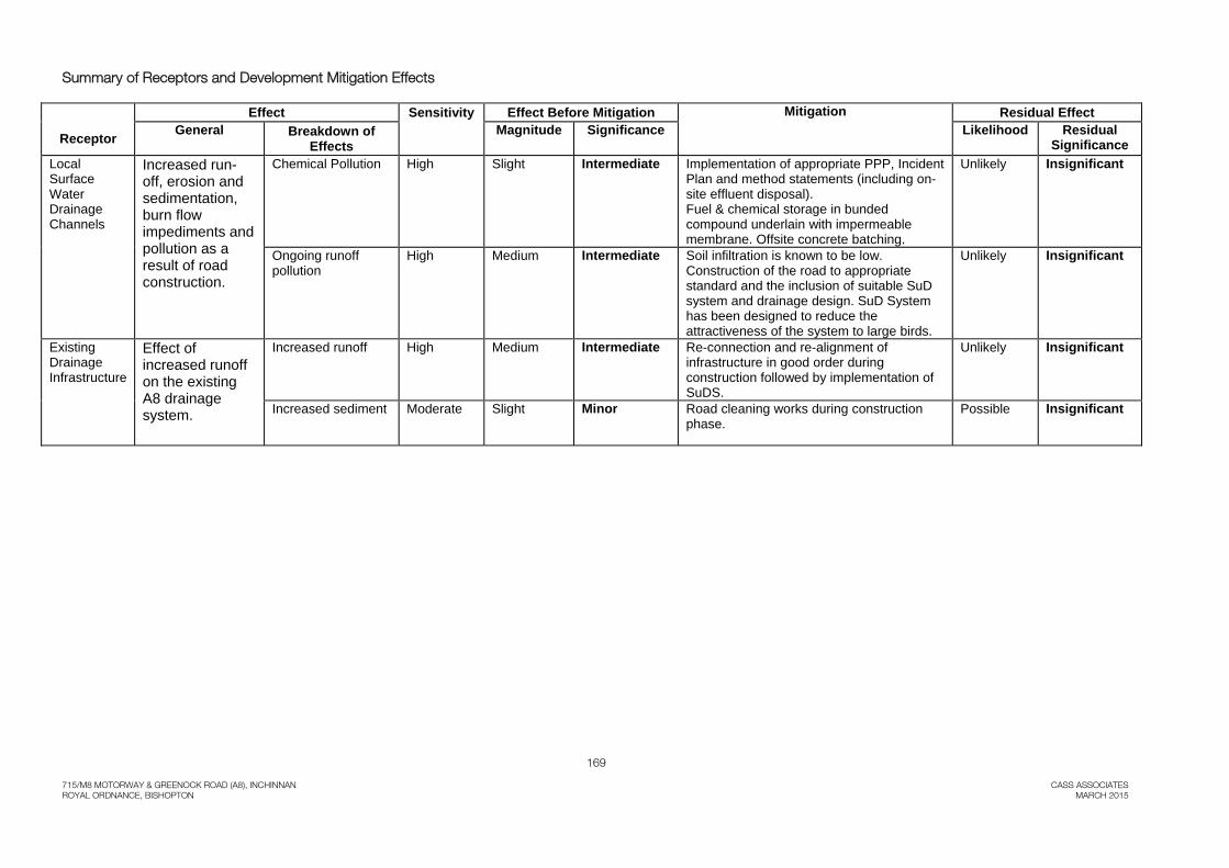
Table 11.11 Summary of Receptors and Development Mitigation Effects
Effect Sensitivity Effect Before Mitigation Mitigation Residual Effect
Receptor General Breakdown of Effects
Magnitude Significance Likelihood Residual Significance
Groundwater Pollution as a result of spillages during road construction and due to ongoing runoff.
Chemical Pollution & Accidental Spillage.
Moderate Slight Minor Implementation of appropriate PPP, Incident Plan and method statements (including on-site effluent disposal). Fuel & chemical storage in bunded compound underlain with impermeable membrane. Offsite concrete batching.
Unlikely Insignificant
Ongoing runoff pollution
Moderate Slight Minor Soil infiltration is known to be low. Construction of the road to appropriate standard and the inclusion of suitable SuD system and drainage design. SuD System has been designed to reduce the attractiveness of the system to large birds.
Unlikely Insignificant
Local Surface Water Drainage Channels
Increased run-off, erosion and sedimentation, burn flow impediments and pollution as a result of road construction.
Increased runoff Moderate Slight Minor Implementation of drainage re-alignment and associated SuDS.
Unlikely Insignificant
Impact on the existing western reed beds
Moderate Medium Intermediate Implementation of reed bed effect on runoff from former landfill and additional development of beds if required
Unlikely Insignificant
Maintenance access to existing drainage features
Moderate Slight Minor Consideration given to ease of infrastructure access within the junction design
Unlikely Insignificant
Increased sediment High Medium Intermediate Timing of construction works and management of runoff.
Possible Minor
169
715/M8 MOTORWAY & GREENOCK ROAD (A8), INCHINNAN CASS ASSOCIATES ROYAL ORDNANCE, BISHOPTON MARCH 2015
Summary of Receptors and Development Mitigation Effects
Effect Sensitivity Effect Before Mitigation Mitigation Residual Effect
Receptor General Breakdown of Effects
Magnitude Significance Likelihood Residual Significance
Local Surface Water Drainage Channels
Increased run-off, erosion and sedimentation, burn flow impediments and pollution as a result of road construction.
Chemical Pollution High Slight Intermediate Implementation of appropriate PPP, Incident Plan and method statements (including on-site effluent disposal). Fuel & chemical storage in bunded compound underlain with impermeable membrane. Offsite concrete batching.
Unlikely Insignificant
Ongoing runoff pollution
High Medium Intermediate Soil infiltration is known to be low. Construction of the road to appropriate standard and the inclusion of suitable SuD system and drainage design. SuD System has been designed to reduce the attractiveness of the system to large birds.
Unlikely Insignificant
Existing Drainage Infrastructure
Effect of increased runoff on the existing A8 drainage system.
Increased runoff High Medium Intermediate Re-connection and re-alignment of infrastructure in good order during construction followed by implementation of SuDS.
Unlikely Insignificant
Increased sediment Moderate Slight Minor Road cleaning works during construction phase.
Possible Insignificant