10.11 Fergusson River - Department of Environment and ... · Melaleuca leucadendra Tree 14/4...
30
149 Fergusson River Top End Waterways Project DALY RIVER CATCHMENT 10.11.1 Fergusson River – Below Edith River Sub-section 13a encompasses the Fergusson River, downstream of the junction with Edith River. Two sites were fully assessed in this sub-section (refer Table 10.30 and Map 42). Table 10.30 Summary of Survey Information for Sub-section 13a – Fergusson River Below Edith River Site Number Tributary Name Sample Point Letter Habitat Type Cross- Section Survey Vegetation Profile Photographic Site A Riffle √ 1 Fergusson River B Pool √ A Pool 2 Fergusson River B Riffle √ √ 10.11 Fergusson River Reach at Site 13a/1 on lower Fergusson River A small riffle at Site 13a/2 on Fergusson River Point bar at Site 13a/1 on lower Fergusson River Pool at Site 13a/2 on Fergusson River
Transcript of 10.11 Fergusson River - Department of Environment and ... · Melaleuca leucadendra Tree 14/4...

149 Fergusson River
Top End Waterways ProjectDALY RIVER CATCHMENT
10.11.1 Fergusson River – Below Edith River
Sub-section 13a encompasses the Fergusson River, downstream of the junction with Edith River. Two siteswere fully assessed in this sub-section (refer Table 10.30 and Map 42).
Table 10.30 Summary of Survey Information for Sub-section 13a – Fergusson River Below Edith River
SiteNumber
Tributary Name SamplePointLetter
HabitatType
Cross-SectionSurvey
VegetationProfile
PhotographicSite
A Riffle √1 Fergusson River
B Pool √
A Pool2 Fergusson River
B Riffle √√
10.11 Fergusson River
Reach at Site 13a/1 on lower Fergusson River
A small riffle at Site 13a/2 on Fergusson River
Point bar at Site 13a/1 on lower Fergusson River
Pool at Site 13a/2 onFergusson River

������������
� ���
����������������������������
�������������������� � !"#������!��$���
�� ��������������� ����
��������
����������� ����!� ������"
����
� �#�����$����
%�������������!� �
� &
'%�(
�
"���
�� ��)* �������
+ , - . / 0+
1� �)����2
����������300��) ,
�
�
���
����
��
����������
���
��
��
�����
�����
�
�
�
�
,�'%�(
0

151 Fergusson River
Top End Waterways ProjectDALY RIVER CATCHMENT
Figure 10.93 Cross-section Surveys for Site 13a/1 – Fergusson River
-2
0
2
4
6
8
10
12
-10 0 10 20 30 40 50 60 70 80 90
Distance (m)
Water Mark Level
FERGUSSON RIVER - SITE 13A/1 (26.9.95)
CROSS-SECTION A - RIFFLE
Bank Height (m)
Depth (m)
Water MarkHigh Bank
Rock outcrops: Bed, right
lower & upper banks
Water Level
-2
0
2
4
6
8
10
12
-10 0 10 20 30 40 50 60 70 80 90 100
Distance (m)
Water Mark Level
FERGUSSON RIVER - SITE 13A/1 (26.9.95)
CROSS-SECTION B - POOL
Bank Height (m)
Depth (m)
Water MarkHigh Bank
Rock outcrops: None
Water Level

152 Fergusson River
Top End Waterways ProjectDALY RIVER CATCHMENT
Figure 10.94 Cross-section Survey for Site 13a/2 – Fergusson River
-2.0
-1.0
0.0
1.0
2.0
3.0
4.0
5.0
6.0
-20 0 20 40 60 80 100 120 140 160 180 200 220
Distance (m)
Water Mark Level
FERGUSSON RIVER - SITE 13A/2 (30.9.95)
CROSS-SECTION B - RIFFLE
Bank Height (m)
Depth (m)
Water MarkHigh Bank
Rock outcrops: None
Water Level
Riffle at Site 13a/2 on Fergusson River downstream of Edith River junction

153 Fergusson River
Top End Waterways ProjectDALY RIVER CATCHMENT

154 Fergusson River
Top End Waterways ProjectDALY RIVER CATCHMENT
Table 10.31 Major Vegetation Species Recorded at Site 1 on Fergusson River located within Sub-section13a
Plant Name – Genus species Structural Type Exotic (E) /Noxious (N)*
Site Where Recorded(Sub-section No. / Site No.)
Barringtonia acutangula Low tree / shrub 13a/1
Casuarina cunninghamiana Tree 13a/1
Chara sp. Forb 13a/1
Coldenia procumbens Forb 13a/1
Cynodon dactylon Grass 13a/1
Dentella repens Forb 13a/1
Eucalyptus camaldulensis Tree 13a/1
Melaleuca argentea Tree 13a/1
Melaleuca leucadendra Tree 13a/1
Nauclea orientalis Tree 13a/1
Passiflora foetida Vine E 13a/1
Xanthium occidentale Forb E/N 13a/1
* Declared Noxious Weed within the Northern Territory
Vegetation along Fergusson River at Site 13a/2 showing area where vegetation profile completed

155 Fergusson River
Top End Waterways ProjectDALY RIVER CATCHMENT
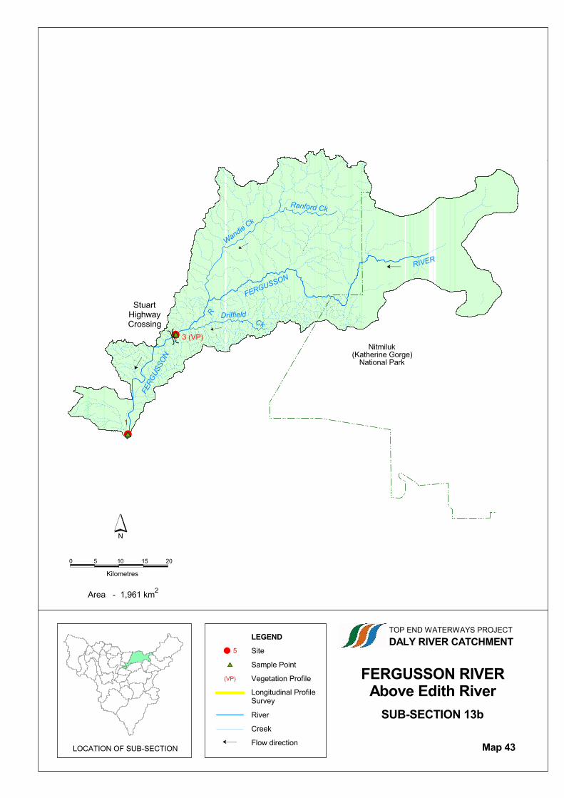
10.11.2 Fergusson River – Above Edith River
Sub-section 13b encompasses the Fergusson River, upstream of the junction with Edith River (excludingEdith River, Eight Mile Creek and Cullen River catchment areas). Two sites were fully assessed in this sub-section (refer Table 10.32 and Map 43).
Table 10.32 Summary of Survey Information for Sub-section 13b – Fergusson River Above Edith River
SiteNumber
Tributary Name SamplePointLetter
HabitatType
Cross-SectionSurvey
VegetationProfile
PhotographicSite
A Riffle √1 Fergusson River
B Pool √
A Pool √3 Fergusson River
B Rapid √√
View of pool at Site 13b/1 on Fergusson River
View of rapid at Site 13b/3 on Fergusson River
A small waterfall on Fergusson River above Site 13b/3
View of pool at Site 13b/3 on Fergusson River
������������
�����
�������������� �������������
�������������������� ��� !���������"���
�� ��������������� ����
��������
����������� ����!� ������"
����
� �#�����$����
%�������������!� �
� &
'%�(
�
����
�� ��)* �������
+ & ,+ ,& -+
.� �)����/
�
����������,012,��)-
�
�
����
����
,
3�'%�(
����
����
�
�
���
���
��������
������ ��
��������
������
��
�
��
�
�
������4��5#�" ��//���
���)� ��'.��5������6����(
������� �����

157 Fergusson River
Top End Waterways ProjectDALY RIVER CATCHMENT
Figure 10.96 Cross-section Surveys for Site 13b/1 – Fergusson River
-2
-1
0
1
2
3
4
5
6
-10 0 10 20 30 40 50 60 70 80
Distance (m)
Water Mark Level
FERGUSSON RIVER - SITE 13B/1 (9.5.96)
CROSS-SECTION A - RIFFLE
Bank Height (m)
Depth (m)
Water MarkHigh Bank
Rock outcrops: Bed, left
& right upper banks
Water Level
-4
-3
-2
-1
0
1
2
3
4
5
6
7
8
-5 0 5 10 15 20 25 30 35 40 45 50 55 60
Distance (m)
Water Mark Level
FERGUSSON RIVER - SITE 13B/1 (9.5.96)
CROSS-SECTION B - POOL
Bank Height (m)
Depth (m)
Water MarkHigh Bank
Rock outcrops: Bed, left
& right upper banks
Water Level

158 Fergusson River
Top End Waterways ProjectDALY RIVER CATCHMENT
Figure 10.97 Cross-section Surveys for Site 13b/3 – Fergusson River
-6
-5
-4
-3
-2
-1
0
1
2
3
4
-5 0 5 10 15 20 25 30 35 40 45 50
Distance (m)
Water Mark Level
FERGUSSON RIVER - SITE 13B/3 (10.5.96)
CROSS-SECTION A - POOL
Bank Height (m)
Depth (m)
Water MarkHigh Bank
Rock outcrops: Bed, left &
right upper & lower banks
Water Level
-2
-1
0
1
2
3
4
5
6
-10 0 10 20 30 40 50 60 70
Distance (m)
Water Mark Level
FERGUSSON RIVER - SITE 13B/3 (10.5.96)
CROSS-SECTION B - RAPID
Bank Height (m)
Depth (m)
Water MarkHigh Bank
Rock outcrops: Bed, left &
right lower & upper banks
Water Level

159 Fergusson River
Top End Waterways ProjectDALY RIVER CATCHMENT

160 Fergusson River
Top End Waterways ProjectDALY RIVER CATCHMENT
Table 10.33 Major Vegetation Species Recorded at Site 1 on Fergusson River located within Sub-section13b
Plant Name – Genus species Structural Type Exotic (E) /Noxious (N)*
Site Where Recorded(Sub-section No. / Site No.)
Acacia auriculiformis Tree 13b/1
Antidesma ghaesembilla Low tree / shrub 13b/1
Barringtonia acutangula Low tree / shrub 13b/1
Calytrix brownii Low tree / shrub 13/b/1
Carallia brachiata Tree 13b/1
Diospyros calycantha Tree 13b/1
Diospyros compacta Tree 13b/1
Eleocharis geniculata Forb 13b/1
Eucalyptus camaldulensis Tree 13b/1
Ficus coronulata Tree 13b/1
Flacourtia territorialis Small tree / shrub 13b/1
Flagellaria indica Vine 13b/1
Germainia truncatiglumis Grass 13b/1
Lophostemon grandiflorus Tree 13b/1
Melaleuca leucadendra Tree 13b/1
Nauclea orientalis Tree 13b/1
Pandanus aquaticus Tree 13b/1
Passiflora foetida Vine E 13b/1
Phragmites karka Grass 13b/1
Phyllanthus reticulatus Low tree / shrub 13b/1
Planchonia careya Tree 13b/1
Strychnos lucida Tree 13b/1
* Declared Noxious Weed within the Northern Territory

161 Fergusson River
Top End Waterways ProjectDALY RIVER CATCHMENT
10.11.3 Edith River
Sub-section 14 includes the catchment of Edith River. Of the 4 sites located within this sub-section, 3 siteswere fully assessed (refer Table 10.34 and Map 44).
Table 10.34 Summary of Survey Information for Sub-section 14 – Edith River
SiteNumber
Tributary Name SamplePointLetter
HabitatType
Cross-SectionSurvey
VegetationProfile
PhotographicSite
A Riffle √2 Edith River
B Pool √√
A Riffle √3 Edith River
B Pool √
4 Edith River A Pool √
6 Granite Creek √
Reach along lower Edith River at Site 14/2 A riffle and pool at Site 14/2 on Edith River
Edith River at Site 14/3 (at Gauge Station 8140152) View across riffle on Edith River at Site 14/3

�������������� �����
����������
�������������������������
���
��������� ����
!�����������������
� "
#!�$
�
������
�� �%&������������������ �����������
������
���� �'�(�� �(�)����* �������������������
+ " ,+ ,"
-���%����.
/����������,0+"1��%
�
�
� �
�
����
���� ��
/�#!�$
2 3
4
�
�
�
�
����������
����
���������
��������
�
��
�����5��6������..���
����������������
���%����#-��6������7����$�������������

163 Fergusson River
Top End Waterways ProjectDALY RIVER CATCHMENT
Figure 10.99 Cross-section Surveys for Site 14/2 – Edith River
-2
-1
0
1
2
3
4
5
6
7
8
9
10
-10 0 10 20 30 40 50 60 70 80 90 100 110 120
Distance (m)
Water Mark Level
EDITH RIVER - SITE 14/2 (17.5.96)
CROSS-SECTION A - RIFFLE
Bank Height (m)
Depth (m)
Water MarkHigh Bank
Rock outcrops: None
Water Level
-2
-1
0
1
2
3
4
5
6
7
8
-10 0 10 20 30 40 50 60 70 80 90 100 110
Distance (m)
Water Mark Level
EDITH RIVER - SITE 14/2 (17.5.96)
CROSS-SECTION B - POOL
Bank Height (m)
Depth (m)
Water MarkHigh Bank
Rock outcrops: None
Water Level

164 Fergusson River
Top End Waterways ProjectDALY RIVER CATCHMENT
Figure 10.100 Cross-section Surveys for Site 14/3 – Edith River
-2
-1.5
-1
-0.5
0
0.5
1
1.5
2
2.5
3
3.5
4
-5 0 5 10 15 20 25 30 35 40 45
Distance (m)
Water Mark Level
EDITH RIVER - SITE 14/3 (9.11.95)
CROSS-SECTION A - RIFFLE
Bank Height (m)
Depth (m)
Water MarkHigh Bank
Rock outcrops: Bed, left lower &
upper banks, right lower & upper banks
Water Level
-2
-1.5
-1
-0.5
0
0.5
1
1.5
2
2.5
3
3.5
4
-2 0 2 4 6 8 10 12 14 16 18 20 22 24 26 28 30
Distance (m)
Water Mark Level
EDITH RIVER - SITE 14/3 (9.11.95)
CROSS-SECTION B - POOL
Bank Height (m)
Depth (m)
Water MarkHigh Bank
Rock outcrops: Bed & left
lower bank
Water Level

165 Fergusson River
Top End Waterways ProjectDALY RIVER CATCHMENT
Figure 10.101 Cross-section Survey for Site 14/4 – Edith River
-2
-1.5
-1
-0.5
0
0.5
1
1.5
2
2.5
3
3.5
4
-2 0 2 4 6 8 10 12 14 16 18 20
Distance (m)
Water Mark Level
EDITH RIVER - SITE 14/4 (17.5.96)
CROSS-SECTION A - POOL
Bank Height (m)
Depth (m)
Water MarkHigh Bank
Rock outcrops: Bed
Water Level
View along pool at Site 14/4 on Edith River, downstream of Edith Falls.

166 Fergusson River
Top End Waterways ProjectDALY RIVER CATCHMENT

167 Fergusson River
Top End Waterways ProjectDALY RIVER CATCHMENT
Table 10.35 Major Vegetation Species Recorded at Sites 3, 4 and 6 on Edith River and Granite Creeklocated within Sub-section 14
Plant Name – Genus species Structural Type Exotic (E) /Noxious (N)*
Sites Where Recorded(Sub-section No. / Site No.)
Acacia dimidiata Low tree / shrub 14/6
Acacia holosericea Low tree / shrub 14/3, 14/4
Antidesma ghaesembilla Low tree / shrub 14/4
Calytrix brownii Low tree / shrub 14/3
Canthium schultzii Low tree / shrub 14/4
Cyperus conicus Forb 14/3
Cyperus haspan Forb 14/3, 14/4
Dichanthium fecundum Grass 14/6
Epaltes australis Forb 14/3
Eragrostis cumingii Grass 14/3
Eucalyptus camaldulensis Tree 14/3
Eucalyptus polycarpa Tree 14/4
Eulalia aurea Grass 14/3
Ficus coronulata Tree 14/3, 14/4
Fimbristylis pauciflora Forb 14/3
Germainia truncatiglumis Grass 14/3
Glinus oppositifolius Forb 14/3
Goodenia purpurascens Forb 14/3
Grevillea pteridifolia Tree 14/3
Hakea arborescens Tree 14/6
Heteropogon contortus Grass 14/3
Hyptis suaveolens Forb E/N 14/3
Lipocarpa microcephala Forb 14/3
Lophostemon grandiflorus Tree 14/3, 14/6
Melaleuca argentea Tree 14/3
Melaleuca leucadendra Tree 14/4
Melaleuca nervosa Low tree / shrub 14/6
Pandanus aquaticus Tree 14/3, 14/4
Passiflora foetida Vine E 14/3, 14/4
Phyllanthus reticulatus Low tree / shrub 14/3
Stemodia lythrifolia Forb 14/3
Tephrosia brachyodon Forb 14/3
Terminalia platyphylla Tree 14/6
Vitex glabrata Tree 14/3
Waltheria indica Low tree / shrub 14/4
* Declared Noxious Weed within the Northern Territory

168 Fergusson River
Top End Waterways ProjectDALY RIVER CATCHMENT
Lophostemon grandiflorus

169 Fergusson River
Top End Waterways ProjectDALY RIVER CATCHMENT
10.11.4 Eight Mile Creek
Sub-section 15 includes the catchment of Eight Mile Creek. One site was fully assessed within this sub-section (refer Table 10.36 and Map 45).
Table 10.36 Summary of Survey Information for Sub-section 15 – Eight Mile Creek
SiteNumber
Tributary Name SamplePointLetter
HabitatType
Cross-SectionSurvey
VegetationProfile
PhotographicSite
A Riffle √2 Eight Mile Creek
B Pool √
Riffle on Eight Mile Creek at Site 15/2

�������������� �����
����������
�������������������������
���
��������� ����
!�����������������
� "
#!�$
�
������
�� �%&��������
����
�� ����������
����������������
���� �'�(�� �(�)����* ����������������������
+���%����,
- . / 0 1 "
�
/����������.2-��%
����� /
�
���������
���

171 Fergusson River
Top End Waterways ProjectDALY RIVER CATCHMENT
Figure 10.103 Cross-section Surveys for Site 15/2 – Eight Mile Creek
-2
-1.5
-1
-0.5
0
0.5
1
1.5
2
-5 0 5 10 15 20 25 30 35
Distance (m)
Water Mark Level
EIGHT MILE CREEK - SITE 15/2 (9.5.96)
CROSS-SECTION A - RIFFLE
Bank Height (m)
Depth (m)
Water MarkHigh Bank
Rock outcrops: Bed, left & right
lower & upper banks
Water Level
-2
-1.5
-1
-0.5
0
0.5
1
1.5
2
-2 0 2 4 6 8 10 12 14 16 18 20 22
Distance (m)
Water Mark Level
EIGHT MILE CREEK - SITE 15/2 (9.5.96)
CROSS-SECTION B - POOL
Bank Height (m)
Depth (m)
Water MarkHigh Bank
Rock outcrops: Bed
Water Level

172 Fergusson River
Top End Waterways ProjectDALY RIVER CATCHMENT
Table 10.37 Major Vegetation Species Recorded at Site 2 on Eight Mile Creek located within Sub-section 15
Plant Name – Genus species Structural Type Exotic (E) /Noxious (N)*
Site Where Recorded(Sub-section No. / Site No.)
Acacia holosericea Low tree / shrub 15/2
Arundinella nepalensis Grass 15/2
Bridelia tomentosa Low tree / shrub 15/2
Cyperus viscidulus Forb 15/2
Eragrostis spartinoides Grass 15/2
Ficus coronulata Tree 15/2
Hyptis suaveolens Forb E/N 15/2
Lophostemon grandiflorus Tree 15/2
Melaleuca argentea Tree 15/2
Melinis repens Grass E 15/2
Passiflora foetida Vine E 15/2
Pennisetum polystachion Grass E/N 15/2
Strychnos lucida Tree 15/2
Terminalia platyphylla Tree 15/2
Waltheria indica Low tree / shrub 15/2
* Declared Noxious Weed within the Northern Territory
Riparian vegetation along Eight Mile Creek (Site 15/2)

173 Fergusson River
Top End Waterways ProjectDALY RIVER CATCHMENT
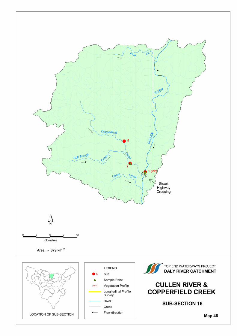
10.11.5 Cullen River and Copperfield Creek
Sub-section 16 includes the catchment of Cullen River. Three sites were fully assessed within this sub-section (refer Table 10.38 and Map 46). The sites were located on the Cullen River (1) and it’s tributary,Copperfield Creek (2).
Table 10.38 Summary of Survey Information for Sub-section 16 – Cullen River and Copperfield Creek
SiteNumber
Tributary Name SamplePointLetter
HabitatType
Cross-SectionSurvey
VegetationProfile
PhotographicSite
A Riffle √1 Cullen River
B Pool √√
A Pool √2 Copperfield Creek
B Riffle √
5 Copperfield Creek √
Reach along Cullen River at Site 16/1 View upstream along Cullen River from Stuart Highway
View along Copperfield Creek at Site 16/2 Riffle on Copperfield Creek at Site 16/2
���������������������� ������
������
�������������
�������������������� � �������������������
�� ��������������� ����
��������
����������� ����!� ������"
����
� �#�����$����
%�������������!� �
� &
'%�(
�
�����
�� ��)* �������
+� �)����,- . / 0 12
�
2����������340��)
��
�
����
���� 1�'%�(2
& �
�
�
�
�
������
�����
�� ��
� ��������
������������ ���
�����
���� �����
�
�
������5��6#�" ��,,���
�

175 Fergusson River
Top End Waterways ProjectDALY RIVER CATCHMENT
Figure 10.104 Cross-section Surveys for Site 16/1 – Cullen River
-2
-1.5
-1
-0.5
0
0.5
1
1.5
2
2.5
3
3.5
4
-5 0 5 10 15 20 25 30 35 40 45
Distance (m)
Water Mark Level
CULLEN RIVER - SITE 16/1 (8.11.95)
CROSS-SECTION A - RIFFLE
Bank Height (m)
Depth (m)
Water MarkHigh Bank
Rock outcrops: Bed & left upper bank
Water Level
Note: Bed Dry at
Sampling Time
-2
-1.5
-1
-0.5
0
0.5
1
1.5
2
2.5
3
3.5
4
-2 0 2 4 6 8 10 12 14 16 18 20 22 24 26
Distance (m)
Water Mark Level
CULLEN RIVER - SITE 16/1 (8.11.95)
CROSS-SECTION B - POOL
Bank Height (m)
Depth (m)
Water MarkHigh Bank
Rock outcrops: None
Water Level
Note: Bed Dry at
Sampling Time

176 Fergusson River
Top End Waterways ProjectDALY RIVER CATCHMENT
Figure 10.105 Cross-section Surveys for Site 16/2 – Copperfield Creek
-2
-1.5
-1
-0.5
0
0.5
1
1.5
2
2.5
3
3.5
4
-10 0 10 20 30 40 50 60 70 80 90 100
Distance (m)
Water Mark Level
COPPERFIELD CREEK - SITE 16/2 (22.9.95)
CROSS-SECTION A - POOL
Bank Height (m)
Depth (m)
Water MarkHigh Bank
Rock outcrops: Bed, left lower &
right upper banks
Water Level
Note: Bed Dry at
Sampling Time
-2
-1.5
-1
-0.5
0
0.5
1
1.5
2
2.5
3
-10 0 10 20 30 40 50 60 70 80 90 100 110
Distance (m)
Water Mark Level
COPPERFIELD CREEK - SITE 16/2 (22.9.95)
CROSS-SECTION B - RIFFLE
Bank Height (m)
Depth (m)
Water MarkHigh Bank
Rock outcrops: None
Water Level
Note: Bed Dry at
Sampling Time

177 Fergusson River
Top End Waterways ProjectDALY RIVER CATCHMENT

178 Fergusson River
Top End Waterways ProjectDALY RIVER CATCHMENT
Table 10.39 Major Vegetation Species Recorded at Sites 2 and 5 on Copperfield Creek located withinSub-section 16
Plant Name – Genus species Structural Type Exotic (E) /Noxious (N)*
Sites Where Recorded(Sub-section No. / Site No.)
Acacia holosericea Low tree / shrub 16/2, 16/5
Arundinella nepalensis Grass 16/2
Calytrix brownii Low tree / shrub 16/2
Cyperus viscidulus Forb 16/2
Eragrostis cumingii Grass 16/2
Eucalyptus polycarpa Tree 16/2
Ficus coronulata Tree 16/5
Flueggea virosa Low tree / shrub 16/5
Germainia truncatiglumis Grass 16/2
Grevillea pteridifolia Tree 16/2
Heteropogon triticeus Grass 16/2
Hibiscus meraukensis Forb 16/2
Hyptis suaveolens Forb E/N 16/2, 16/5
Lophostemon grandiflorus Tree 16/2, 16/5
Melaleuca argentea Tree 16/2, 16/5
Pandanus aquaticus Tree 16/2, 16/5
Passiflora foetida Vine E 16/2, 16/5
Staurogyne leptocaulis Forb 16/2
Terminalia platyphylla Tree 16/2, 16/5
* Declared Noxious Weed within the Northern Territory
Riparian vegetation along Cullen River (Site 16/1) Collecting vegetation samples for identification