1002w200s PLNSUB2016-01000 EuclidCorners Staff Report ... Commission/2017/00.pdf · Staff Report...
40
SALT LAKE CITY CORPORATION 451 SOUTH STATE STREET, ROOM 406 WWW.SLCGOV.COM PO BOX 145480 SALT LAKE CITY, UT 84114-5480 TEL 801-535-7757 FAX 801-535-6174 PLANNING DIVISION COMMUNITY & ECONOMIC DEVELOPMENT Staff Report To: Salt Lake City Planning Commission From: J.P. Goates, 801-535-7236, [email protected] Date: February 22, 2016 Re: PLNSUB2016-01000 – Euclid Corners Townhomes PLNSUB2017-00032 – Euclid Corners Preliminary Subdivision Planned Development & Preliminary Subdivision PROPERTY ADDRESS: 1002 West 200 South PARCEL ID: 15-02-178-025 MASTER PLAN: North Temple Boulevard Master Plan ZONING DISTRICT: TSA-UN-T, Transit Station Area Urban Neighborhood Transition REQUEST: Pascal Meyer of Carpenter Stringham Architects, on behalf of the property owner, is requesting approval from the City to develop a proposed 16‐unit townhome project at approximately 1002 West 200 South. The applicant is requesting Planned Development approval for modifications of certain zoning standards related to setbacks abutting an RMF‐ 35 district, first floor glass requirements, lots not fronting a public street and minimum lot size. Consideration of these types of modifications must be reviewed as a Planned Development. The applicant is also requesting Preliminary Subdivision approval as part of the request. Currently the land is vacant and the property is zoned TSA-UN-T, Transit Station Area Urban Neighborhood Transition. RECOMMENDATION (Planned Development): Based on the findings listed in the staff report, it is the Planning Staff’s opinion that overall the project generally meets the applicable standards and therefore, recommends the Planning Commission approve the Planned Development and Preliminary Subdivision request. Staff recommends the following motion: Based on the information in the staff report, public testimony, and discussion by the Planning Commission, I move that the Planning Commission approve petitions PLNSUB2016-01000 and PLNSUB2017-00032, regarding the Euclid Corners Townhomes Planned Development and Preliminary Subdivision request. In order to comply with the applicable standards, the following conditions of approval apply: 1. The applicant shall comply with all other Department/Division conditions provided to the applicant. 2. All other applicable zoning standards not modified by the Planned Development approval shall apply to the development. 3. The applicant shall follow through with a Real Estate Services to obtain a revocable permit for steps in the public right-of-way. 4. The section of the alley adjacent to the property will be have posted no parking signs.
Transcript of 1002w200s PLNSUB2016-01000 EuclidCorners Staff Report ... Commission/2017/00.pdf · Staff Report...

SALT LAKE CITY CORPORATION 451 SOUTH STATE STREET, ROOM 406 WWW.SLCGOV.COM PO BOX 145480 SALT LAKE CITY, UT 84114-5480 TEL 801-535-7757 FAX 801-535-6174
PLANNING DIVISION COMMUNITY & ECONOMIC DEVELOPMENT
Staff Report
To: Salt Lake City Planning Commission From: J.P. Goates, 801-535-7236, [email protected] Date: February 22, 2016 Re: PLNSUB2016-01000 – Euclid Corners Townhomes
PLNSUB2017-00032 – Euclid Corners Preliminary Subdivision
Planned Development & Preliminary Subdivision
PROPERTY ADDRESS: 1002 West 200 South PARCEL ID: 15-02-178-025 MASTER PLAN: North Temple Boulevard Master Plan ZONING DISTRICT: TSA-UN-T, Transit Station Area Urban Neighborhood Transition REQUEST: Pascal Meyer of Carpenter Stringham Architects, on behalf of the propertyowner,isrequestingapprovalfromtheCitytodevelopaproposed16‐unittownhomeprojectatapproximately1002West200South.TheapplicantisrequestingPlannedDevelopmentapprovalformodificationsofcertainzoningstandardsrelatedtosetbacksabuttinganRMF‐35district,firstfloorglassrequirements,lotsnotfrontingapublicstreetandminimumlotsize.Consideration of these types of modifications must be reviewed as a Planned Development. The applicant is also requesting Preliminary Subdivision approval as part of the request. Currently the land is vacant and the property is zoned TSA-UN-T, Transit Station Area Urban Neighborhood Transition. RECOMMENDATION (Planned Development): Based on the findings listed in the staff report, it is the Planning Staff’s opinion that overall the project generally meets the applicable standards and therefore, recommends the Planning Commission approve the Planned Development and Preliminary Subdivision request. Staff recommends the following motion: Based on the information in the staff report, public testimony, and discussion by the Planning Commission, I move that the Planning Commission approve petitions PLNSUB2016-01000 and PLNSUB2017-00032, regarding the Euclid Corners Townhomes Planned Development and Preliminary Subdivision request. In order to comply with the applicable standards, the following conditions of approval apply:
1. The applicant shall comply with all other Department/Division conditions provided to the applicant.
2. All other applicable zoning standards not modified by the Planned Development approval shall apply to the development.
3. The applicant shall follow through with a Real Estate Services to obtain a revocable permit for steps in the public right-of-way.
4. The section of the alley adjacent to the property will be have posted no parking signs.

2 PLNSUB2016-01000 and PLNSUB2017-00032
5. The applicant will submit a Final Subdivision plat for the project with private infrastructure cost disclosures within 18 months of Preliminary Subdivision approval.
6. Final approval authority for the development shall be delegated to Planning staff based on the applicant’s compliance with the standards and conditions of approval as noted within this staff report.
ATTACHMENTS: A. Vicinity Map B. Preliminary Plat C. Site Plan D. Elevations E. Additional Applicant Information and TSA Score F. Property Photographs G. Existing Conditions & Zoning H. Analysis of Standards – Planned Development I. Analysis of standards – Preliminary Subdivision J. Public Process and Comments K. Department Review Comments L. Potential Motions
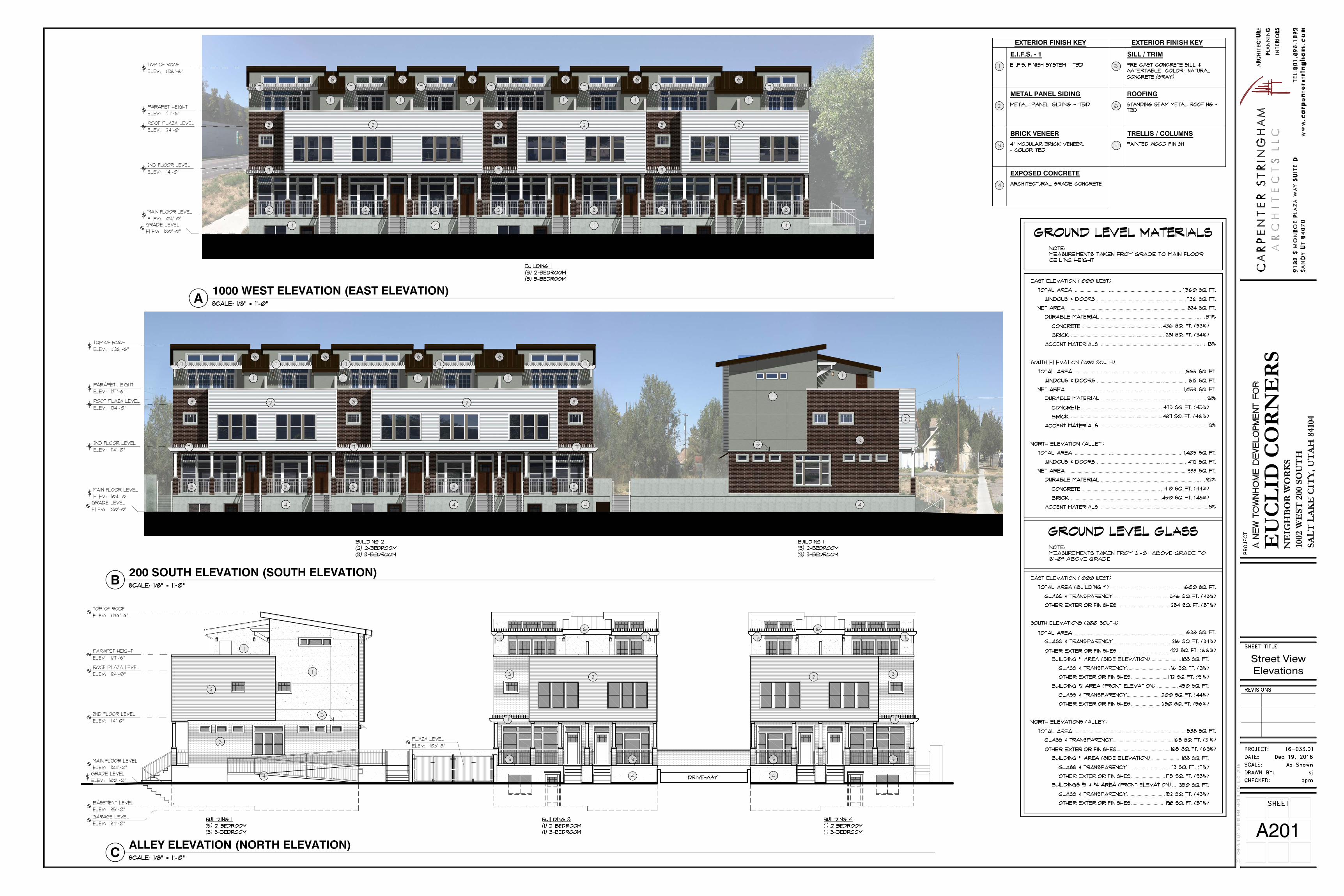
PROJECT DESCRIPTION: PLANNED DEVELOPMENT The applicant is proposing to develop a .54 acre vacant lot with a 16 unit townhome development. The proposed construction will be podium type construction with a one level below grade parking garage with three-story units above. Half of the units are three bedroom and half are two bedroom. There is a 5,900 square foot open space courtyard at the interior above the parking structure and half of the 16 proposed units will be on 800 square foot lots and half on 600 square foot lots. The parking structure will be approximately six feet below grade and buildings above will reach approximately 35 feet in height above grade. The parking will be accessed via the 16 foot wide public alley located at the North edge of the property. The building entrances are to be located at the street levels of 1000 W and 200 South with a stoop entrance, and at the courtyard level at the rear of the units. The units will also gain access from the parking garage, which contains two spaces for the three bedroom units and one space for two bedroom units. The following items detail the modifications to the ordinance and rationale for the Planned Development. This also includes modifications relating to the Preliminary Subdivision. 1. Modification of 25 foot setback requirement in side yard The TSA-UN-T district does not require any setback for this district unless the property abuts certain residential districts. In this case the property to the North is zoned RMF-35, and requires a 25 foot setback from the property line with one foot of step back of one foot for every one foot

3 PLNSUB2016-01000 and PLNSUB2017-00032
in height over 25 feet. The proposed setback is approximately 17 feet resulting in an approximate eight foot encroachment into the setback, and will require a modification through Planned Development approval. The alley abutting this required yard is 16 feet wide and with that included, the distance from the buildings to the property line will be 33 feet and the nearest single family home being an approximate 60 feet from the alley. The applicable area is shown on the right in the red oval. 2. Modification of first floor glass requirement The second modification requested is for a reduction in the first floor glass requirement. The street facing front entrance facades of each unit meet the first floor glass requirement of 40% glass, between three and eight feet above grade for residential uses. The North and South ends of the East facing units (shown in blue on the above) face public rights of way and have approximately 10% glass proposed. This does not meet the standard due to internal functions of the building, and the floor level being four feet above grade. The glass being proposed on the elevated ground floor is 25% however. The applicant has made substantial effort to meet the intent of the ordinance with windows spanning the length of the façade, including one large bay window and several clerestory windows. PRELIMINARY SUBDIVISION The proposed subdivision is for 16 individual for sale lots with common area surrounding them. The General Provisions in Chapter 21A.36 requires that all lots front on a public street. 3. Modification for lots that do not front a public street. As shown in Attachment B, the proposed subdivision is for 16 individual lots and common area with only one of the individual units with a property line that fronts the street. This modification is necessary for creation of a common space to be managed by a homeowners association including the parking structure, drive isles and garbage collection areas. The design of the buildings are unique in that they all share underground parking drive access areas that function similar to condominiums. However, the units will be on their own lots with below grade tucked under garages. 4. Modification of minimum lot size required The TSA Districts require a minimum lot size of 2,500 square feet. The proposed development is unique in that the townhome units will be for sale as single family attached units on individual lots. The typical development type in the TSA district is for condominium or apartment residential units. The individual units will be on lots of 600 and 800 square feet.
25’ setback line
<40% ground floor glass

4 PLNSUB2016-01000 and PLNSUB2017-00032
KEY ISSUES: The Planning Staff has solicited comments and input from the applicable departments within the City, the Poplar Grove Community Council, and held a public open house. The comments received did not reflect any significant concerns or key issues. These comments can be found in Attachment J for public comment and Attachment K for City department comments. DISCUSSION: As discussed above and in Attachment H, the proposal generally meets the standards for Planned Development consideration. The requested modifications would generally result in a more enhanced product than would otherwise be allowed with strict application of the zoning ordinance standards.
The proposed development would function as an additional housing option to the neighborhood where a vacant lot consisting of weeds and dilapidated infrastructure currently exists. The neighborhood has been identified in the North Temple Boulevard plan as one that should transition into a mixed use, medium density development pattern. The proposed project meets those criteria.
The allowed height in the TSA-UN-T is 50 feet. This would allow for a much larger structure and higher density than what is being proposed and that height and density of what is allowed by right may not fit the context and character of the neighborhood. The surrounding properties, while zoned for higher densities, are primarily single family detached structures. The proposed height and density of the project at 35 feet and 16 units more closely fits the context of the existing conditions and for a transitioning neighborhood.
The required 25 foot setback and building stepback when adjacent to RMF-35 zones was intended to address issues that could arise when a 50 foot building would abut smaller scale residential uses. In this case, the proposed structure is being built to the same 35 foot height requirement of the RMF-35 property to the North. With the modified setback and stepback, the separation between the property to the North and the closest building will include a 16 foot alley and an approximate 17 foot setback from the property line and the façade will not be stepped back. Strict adherence to the setback would result in a 41 foot separation between the building and the North property line and the building being stepped back 10 additional feet on the façade reaching over 25 feet. The proposed setback will result in a 33 foot separation from the neighboring South property lines with the façade remaining vertically in line. This setback configuration is more in line with what currently exists in the surrounding area.
The abutting property to the West is also zoned TSA-UN-T and contains single family structures. The proposed setback at the West edge of the property is approximately two feet for the parking structure and six feet for residential buildings. The separation between the residential structure to the West will be approximately 10 feet from the parking structure and 16 feet at the residential portion of the structure.
5 PLNSUB2016-01000 and PLNSUB2017-00032
The end units facing 200 South and the public alley would typically be required to provide 40% glass between 4 and 8 feet and approximately 10% is being proposed. In this area of the buildings, the facades are limited by mechanical and interior function of the building. At these locations, the applicant has worked with staff to include a large window in the center of each façade, and place smaller clerestory windows across the remaining façade area. In addition, the applicant has worked with staff in adding the same window treatment to interior and side yard facing facades where none are required.
The type of development proposed is located in an area primarily dominated by single family homes. The area has also been called out in the North Temple Boulevard Plan as one that should transition to medium density and mixed use type uses. The proposed project falls in line with what is called for in the plan while acknowledging the current single family nature and existing condition.
NEXT STEPS: Planned Development and Preliminary Subdivision Approval If the Planned Development is approved, the applicant will need to need to comply with the conditions of approval, including any of the conditions required by City departments and the Planning Commission. The applicant will then be able to submit for building permits for the development. The applicant will also need to submit a final subdivision plat to finalize the proposed property boundaries. Final certificates of occupancy for the buildings will not be issued until the conditions are met and the final subdivision plat is recorded to establish property lines.
Windows on final submission Initial submission
Image and caption from the North Temple Boulevard Plan of housing type desired in the area. The proposed units reflect this housing type.

6 PLNSUB2016-01000 and PLNSUB2017-00032
Planned Development and Preliminary Subdivision Denial If the Planned Development is denied, the applicant could potentially develop the lot with one building and a different property configuration, the applicant would also need to provide the full perimeter parking lot landscaping at the west edge of the lot. The shared drive access straddling the lot line would need to be replaced with the required 7 foot buffer.
7 PLNSUB2016-01000 and PLNSUB2017-00032
ATTACHMENT A: VICINITY MAP

8 PLNSUB2016-01000 and PLNSUB2017-00032
ATTACHMENT B: PRELIMINARY SUBDIVISION PLAT

63.97
'
S 89°59'12" W 64.00'
LOT 6LOT 7
BLOCK 44
1000
WES
T ST
REET
S 0°
00'48
" E 3
94.03
' (N0°
00'55
"W 39
3.97')
BASIS OF BEARING: S 89°58'19" W 792.46' (792.00')
64.00'
63.97
'
16.0' ALLEYWAYDRIVEWAY
(A P
AVED
PUB
LIC R
IGHT
OF
WAY
)
200 SOUTH STREET(A PAVED PUBLIC RIGHT OF WAY)
15-02-178-024AUBERY, MEGAN K
15-02-178-016BILLS, JESS A. & ANN S.
15-02-178-015WINTERS, JESS &MILLICH, DEBRA
15-02-178-014MEJIA, WILKIN
15-02-178-013SWENSON, ROBERT A.
FOUND SALT LAKE CITYBRASS CAP MONUMENTSET IN RING & LID
SET REBAR& CAP
SET 1/2" COPPER RIVETON LOT LINE EXTENSION8.1' EAST OF CORNER
FOUND 5/8"REBAR W/ NO CAP
SET 1/2" COPPER RIVETON LOT LINE EXTENSION9.4' SOUTH OF CORNER
NOT SET
NOT SET
NOT SET
FOUND 1.5"STEEL PIPE
FOUND SALT LAKE CITYBM # 1497 EL.=4225.94' (NAVD88)
N 42°27
'05" E
73.54
'
170.12' 63.98'
N 0°
00'42
" W 6
3.95'
137.0
3'15
2.75'
S 89°58'19" W 170.12'
N 0°00'48" W
137.04'
N 89°58'24" E 170.12'
S 0°00'48" E
137.03'
6.12'
N 0°01'41" W5.00'
90.00'
S 0°01'41" E4.98'
S 0°
01'36
" E17
.02'
44.97'29.04'35.00'20.00'41.11'
S 0°
01'36
" E 2
7.52'
S 0°
01'36
" E 2
7.52'
S 0°
01'36
" E 2
7.51'
N 89°59'12" E6.12'
27.50
'
24.5'
20.4'
24.5'
29.0'
29.0'
20.0'
29.0'
LOT: 1
600 SQFT0.014 ACRES
LOT: 2
814 SQFT0.019 ACRES
LOT: 3
600 SQFT0.014 ACRES
LOT: 4
799 SQFT0.018 ACRES
LOT: 5
601 SQFT0.014 ACRES
LOT: 6
600 SQFT0.014 ACRES
LOT: 7
786 SQFT0.018 ACRES
LOT: 8
800 SQFT0.018 ACRES
LOT: 9
614 SQFT0.014 ACRES
LOT: 10
799 SQFT0.018 ACRES
LOT: 11
601 SQFT0.014 ACRES
LOT: 12
786 SQFT0.018 ACRES
LOT: 13
800 SQFT0.018 ACRES
LOT: 14
600 SQFT0.014 ACRES
LOT: 15
600 SQFT0.014 ACRES
LOT: 16
800 SQFT0.018 ACRES
15.00
'
N 89°59'12" E 40.00'
15.00
'
S 89°59'12" W 40.00'
20.35
'
40.00'
20.35
'
15.00
'
40.00'
15.00
'
N 0°
00'48
" W 1
9.98'
40.00'S 0°
00'48
" E 1
9.98'
15.02
'
40.00'
15.02
'
15.00
'
N 89°59'12" E 40.00'
15.00
'
19.65
'
N 89°59'12" E 40.00'
19.65
'
N 0°
00'48
" W 4
0.00'
20.00'
S 0°
00'48
" E 4
0.00'
20.00'
15.35'
40.00
'
15.35'
N 89°59'12" E 19.98'
40.00
'
S 89°59'12" W 19.98'
15.02'
S 0°
00'48
" E 4
0.00'
15.02'
19.65'
S 0°
00'48
" E 4
0.00'
19.65'
40.00
'
N 89°59'12" E 20.00'
S 0°
00'48
" E 4
0.00'
S 89°59'12" W 20.00'
N 0°
00'48
" W 4
0.00'
15.00'
15.00'
40.00
'
15.00'
S 0°
00'48
" E 4
0.00'
15.00'
N 0°
00'48
" W 4
0.00'
N 89°59'12" E 20.00'
S 89°59'12" W 20.00'
5.0'
5.0'
68.00'
63.97
'
N 0°
00'47
" W 3
94.07
' (N0°
00'55
"W 39
3.97')
S 0°
00'47
" E 3
99.67
'
1100
WES
T ST
REET
FOUND SALT LAKE CITYBRASS CAP MONUMENTSET IN RING & LID
40.00
'
68.00'
N 89°58'30" E 792.46' (N89°58'19"E 792.00')EUCLID AVENUE.
SALT LAKE CITYMONUMENT (NOT FOUND)
64.00'
40.00
'
N 89°58'30" E 792.18' (N89°58'22"E 792.00')
FOUND SALT LAKE CITYBRASS CAP MONUMENTSET IN RING & LID
40.01
'
FOUND SALT LAKE CITYBRASS CAP MONUMENTSET IN RING & LID
S 0°
00'47
" E 3
94.04
'
FOUND SALT LAKE CITYBRASS CAP MONUMENTSET IN RING & LID
FOUND SALT LAKE CITYBRASS CAP MONUMENTSET IN RING & LID
SCALE: 1" =
NORTH
20'
0 10' 20' 40' 60'
FLOOD ZONE
SITE BENCHMARK IS BM# 1497 WITH ANELEVATION OF 4225.94' (NAVD88) PUBLISHEDBY THE SALT LAKE CITY SURVEYOR'S OFFICE
EUCLID CORNER PRELIMINARY SUBDIVISION
CITY PLANNING DIRECTOR
PLANNING DIRECTOR
APPROVED THIS _________________ DAY OF _____________________ A.D., 20____,BY THE SALT LAKE CITY PLANNING COMMISSION.
CITY APPROVAL
SALT LAKE CITY RECORDER
PRESENTED TO SALT LAKE CITY THIS _________________ DAY OF _____________________ A.D.,20____, AND IT IS HEREBY APPROVED.
SALT LAKE CITY MAYOR
CITY ENGINEERING DIVISION
CITY ENGINEER DATE CITY SURVEYOR DATE
I HEREBY CERTIFY THAT I HAVE HAD THIS PLAT EXAMINED BY THIS OFFICE AND IT IS CORRECT INACCORDANCE WITH THE INFORMATION ON FILE.
COUNTY HEALTH DEPARTMENT
SALT LAKE COUNTY HEALTH DEPARTMENT
APPROVED THIS _________________ DAY OF _____________________ A.D., 20____,
CITY ATTORNEY
APPROVED THIS _________________ DAY OF _____________________ A.D., 20____,
SALT LAKE CITY ATTORNEY
OF
SHEET
4
1
CITY PUBLIC UTILITIES DEPARTMENT
SALT LAKE CITY PUBLIC UTILITIES DIRECTOR
APPROVED THIS _________________ DAY OF _____________________ A.D., 20____,
NOTE: MEETS MINIMUM ALLOWABLE ERROR OF 1:15000 FOR CLASS A SURVEYS
EUCLID CORNER PRELIMINARY SUBDIVISION
A RESIDENTIAL PLANNED UNITY DEVELOPMENTLOCATED IN THE NORTHWEST CORNER OF SECTION 02, TOWNSHIP 1 SOUTH,
RANGE 1 WEST SALT LAKE BASE AND MERIDIAN.1002 WEST 200 SOUTH, SALT LAKE CITY, UTAH
A UTAH CONDOMINIUM PROJECT
SURVEYOR'S CERTIFICATE
OWNER'S DEDICATION
BOUNDARY DESCRIPTION
DENNIS K. WITHERSL.S. LICENSE NO. 6135190
SALT LAKE NEIGHBORHOOD HOUSING SERVICES, THE OWNER OF THE DESCRIBED TRACT OF LAND TO BE HEREAFTER KNOWN AS EUCLIDCORNER PRELIMINARY SUBDIVISION DOES HEREBY DEDICATE FOR THE PERPETUAL USE OF THE PUBLIC ALL STREETS, EASEMENTS ANDOTHER PROPERTY AS SHOWN ON THIS PLAT AND HEREBY CONSENTS AND GIVES APPROVAL TO THE RECORDING OF THIS PLAT FOR ALLPURPOSES SHOWN THEREIN.
IN WITNESS WHEREOF, I HAVE HEREUNTO SET MY HAND THIS ____ DAY OF _________________, 20____.
SALT LAKE NEIGHBORHOOD HOUSING SERVICES
BY: _______________________________________________________
PRINT NAME: ______________________________________________
TITLE: ____________________________________________________
CORPORATE ACKNOWLEDGMENT
STATE OF UTAHCOUNTY OF SALT LAKE
ON THE ______ DAY OF ____________, 20____, ____________________ PERSONALLY APPEARED BEFORE ME, WHO BEING BY ME DULYSWORN, DID ACKNOWLEDGE THAT HE/SHE IS THE MANAGER OF SALT LAKE NEIGHBORHOOD HOUSING SERVICES, A UTAH LIMITED LIABILITYCOMPANY, AND THAT THE FOREGOING OWNER'S DEDICATION REGARDING THE EUCLID CORNER PRELIMINARY SUBDIVISION WAS SIGNED BYHIM/HER ON BEHALF OF SAID SALT LAKE NEIGHBORHOOD HOUSING SERVICES.
COMMISSION NUMBER ___________________
MY COMMISSION EXPIRES _________________
________________________________ ______________________________________PRINTED NAME A NOTARY PUBLIC COMMISSIONED IN UTAH
S.S.
DATE
LIEN HOLDER'S CONSENT TO RECORD
ON APRIL 25, 2012, WELLS FARGO BANK, NATIONAL ASSOCIATION, A PUBLIC ENTITY, ENTERED INTO A DEED OF TRUST, ASSIGNMENT OFRENTS, SECURITY AGREEMENT AND FINANCING STATEMENT (“DEED OF TRUST”) WITH SALT LAKE NEIGHBORHOOD HOUSING SERVICES, AUTAH LIMITED LIABILITY COMPANY, AND EUCLID CORNER HOUSING L.L.C., A UTAH LIMITED LIABILITY COMPANY TO WELLS FARGO BANKNORTHWEST, NATIONAL ASSOCIATION, TRUSTEE, FOR THE BENEFIT OF WELLS FARGO BANK, NATIONAL ASSOCIATION, BENEFICIARY,DATED APRIL 25, 2012 AND RECORDED MAY 1, 2012 AS ENTRY NO.: 11632137, IN BOOK 1013, AT PAGE 2534. MODIFIED BY THAT CERTAINMODIFICATION AGREEMENT AMENDING DEED OF TRUST RECORDED MARCH 27, 2014 AS ENTRY NO.: 11824687 IN BOOK 10219 AT PAGE 8760.SAID DEED OF TRUST WAS PARTIALLY RE-CONVEYED TO OTHER PROPERTY BY INSTRUMENT RECORDED DECEMBER 18, 2014 AS ENTRYNO.: 11964650 IN BOOK 10283 AT PAGE 2129.
WELLS FARGO BANK NORTHWEST, NATIONAL ASSOCIATION IS FULLY AWARE THAT EUCLID CORNER GROUP L.L.C. IS IN THE PROCESS OFRECORDING A PLAT CREATING A CONDOMINIUM PROJECT KNOWS AS EUCLID CORNER PRELIMINARY SUBDIVISION AND WELLS FARGO BANKNORTHWEST, NATIONAL ASSOCIATION HEREBY CONSENTS TO THE PLAT FOR ALL PURPOSES SHOWN HEREON.
DATED THIS ____ DAY OF ____________________, 2015.
By: _________________________________________
Printed Name:__________________________________
Its: __________________________________________
ACKNOWLEDGEMENT
STATE OF UTAHCOUNTY OF SALT LAKE
ON THE ______ DAY OF ____________, 20____, PERSONALLY APPEARED BEFORE ME _____________________________, WHO BEING BY ME DULYSWORN, DID ACKNOWLEDGE THAT HE/SHE IS THE ___________________ OF __________________________, AND THAT THE FOREGOINGINSTRUMENT WAS SIGNED BY HIM/HER ON BEHALF OF: WELLS FARGO BANK NORTHWEST, NATIONAL ASSOCIATION.
COMMISSION NUMBER ___________________
MY COMMISSION EXPIRES _________________
__________________________________ ______________________________________ (PRINT NAME) A NOTARY PUBLIC COMMISSIONED IN UTAH
S.S.
BUILDING OFFICIAL
SALT LAKE CITY PUBLIC UTILITIES DIRECTOR
APPROVED THIS _________________ DAY OF _____________________ A.D., 20____,
SALT LAKE COUNTY RECORDER
RECORD NO. ______________________________.
STATE OF UTAH, COUNTY OF SALT LAKE, RECORDED AND FILED AT THE REQUEST OF____________________________________________________________
DATE: ________________________ TIME: ____________________________ BOOK: __________________________ PAGE: _________________________
FEE $ ######### COUNTY RECORDER
VICINITY MAP
S
I
T
E
LINCOLN HWY (I-80)
VETE
RANS
MEM
ORIA
L HW
Y (I-
15)
1000
WES
T
900 W
EST
FOLSOM AVE.
SOUTH TEMPLE
EERIL AVE.
NORTH TEMPLE
800 W
EST
JERE
MY S
T.
EUCLID AVE.
200 SOUTH
LOT 2 THRU 5, BLOCK 1 KELSEY AND GILLESPIE SUBDIVISION OF BLOCK 44, PLAT 'C' ACCORDING TO THE OFFICIAL PLAT THEREOF, ANDBEING MORE PARTICULARLY DESCRIBED AS FOLLOWS:
BEGINNING AT THE SOUTHEAST CORNER OF SAID LOT 02, SAID CORNER BEING NORTH 0°00'48" WEST, ALONG THE 1000 WEST STREETMONUMENT LINE, A DISTANCE OF 63.95 FEET AND SOUTH 89°59'12" WEST, PERPENDICULAR TO SAID MONUMENT LINE, A DISTANCE OF 64.00FEET, FROM THE SALT LAKE CITY MONUMENT MARKING THE INTERSECTION OF 200 SOUTH AND 1000 WEST STREET (BASIS OF BEARINGBEING SOUTH 89°58'19" WEST, ALONG THE 200 SOUTH STREET MONUMENT LINE, BETWEEN MONUMENT FOUND AT 1000 WEST AND 1100WEST) AND RUNNING THENCE SOUTH 89°58'19" WEST, ALONG THE NORTH LINE OF SAID 200 SOUTH STREET, A DISTANCE OF 170.12 FEET,TO THE WEST LINE OF SAID LOT 5; THENCE NORTH 0°00'48" WEST, ALONG SAID WEST LINE, A DISTANCE OF 137.04 FEET, TO THENORTHWESTERLY CORNER THEREOF AND THE SOUTH LINE OF 16.0' WIDE ALLEYWAY; THENCE NORTH 89°58'24" EAST, ALONG THE SOUTHLINE OF SAID ALLEYWAY AND THE NORTHERLY LINES OF LOTS 2 TRHU 5, A DISTANCE OF 170.12 FEET, TO THE WESTERLY LINE OFAFORESAID 1000 WEST STREET; THENCE SOUTH 0°00'48" EAST, ALONG SAID WESTERLY LINE, BEING THE EAST LINE OF SAID LOT 2, ADISTANCE OF 137.03 FEET, TO THE POINT OF BEGINNING.
CONTAINS: 23,311 SQUARE FEET, OR 0.535 ACRES.
A RESIDENTIAL PLANNED UNIT DEVELOPMENTLOCATED IN THE NORTHWEST CORNER OF SECTION 02, TOWNSHIP 1 SOUTH, RANGE 1 WEST,
SALT LAKE BASE AND MERIDIAN.1002 WEST 200 SOUTH, SALT LAKE CITY, UTAH
A UTAH CONDOMINIUM PROJECT.
THE SUBJECT PARCEL IS SITUATE WITHIN ZONE 'X', AREAS DETERMINED TO BE OUTSIDETHE 2% ANNUAL CHANCE OF FLOOD, PER FEMA MAP NO.: 49035C0143E, BEARING ANEFFECTIVE DATE OF SEPTEMBER 21, 2001.
LOT LINES
LOT LINE
PROPERTY LINE
MONUMENT LINE
EASEMENT LINE
FIRE HYDRANT
LEGEND
I, DENNIS K. WITHERS, DO HEREBY CERTIFY THAT I AM A PROFESSIONAL LAND SURVEYOR, AND THAT I HOLD LICENSE NO. 6135190, ASPRESCRIBED UNDER THE LAWS OF THE STATE OF UTAH. I FURTHER CERTIFY THAT BY AUTHORITY OF THE OWNERS, I HAVE MADE A SURVEY OFTHE TRACT OF LAND SHOWN ON THIS PLAT AND DESCRIBED BELOW, AND HAVE SUBDIVIDED SAID TRACT OF LAND INTO LOTS AND STREETSHEREAFTER TO BE KNOWN AS:
AND THAT THE SAME HAS BEEN CORRECTLY SURVEYED AND STAKED ON THE GROUND AS SHOWN ON THIS PLAT.
EUCLID CORNER PRELIMINARY SUBDIVISION
PRIVATE OWNERSHIP
COMMON AREA
AutoCAD SHX Text
}
AutoCAD SHX Text
}
Kent
Seal-UT-Svy
Kent
Withers Signature

9 PLNSUB2016-01000 and PLNSUB2017-00032
ATTACHMENT C: SITE PLAN


10 PLNSUB2016-01000 and PLNSUB2017-00032
ATTACHMENT D: ELEVATIONS

11 PLNSUB2016-01000 and PLNSUB2017-00032
ATTACHMENT E: ADDITIONAL APPLICANT INFORMATION

12 PLNSUB2016-01000 and PLNSUB2017-00032
TSA REVIEW SCORING SHEET
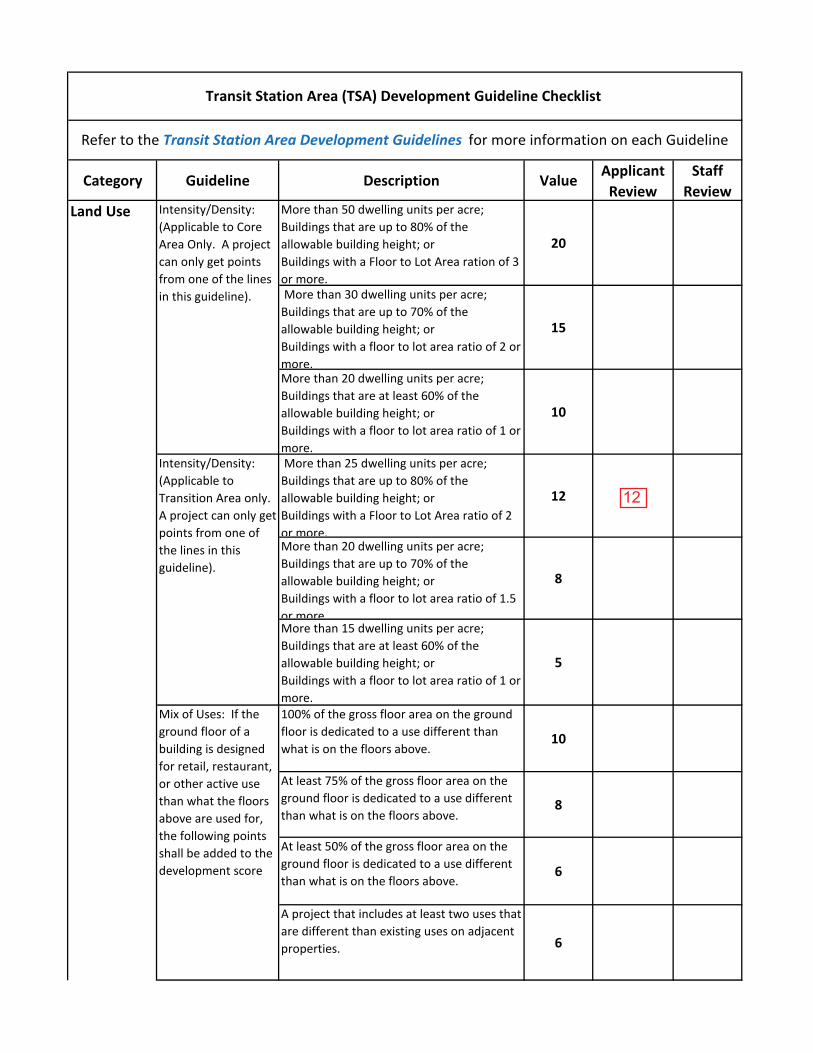
Category Guideline Description ValueApplicant
ReviewStaff
ReviewMore than 50 dwelling units per acre;Buildings that are up to 80% of the allowable building height; or Buildings with a Floor to Lot Area ration of 3 or more.
20
More than 30 dwelling units per acre;Buildings that are up to 70% of the allowable building height; orBuildings with a floor to lot area ratio of 2 or more.
15
More than 20 dwelling units per acre;Buildings that are at least 60% of the allowable building height; orBuildings with a floor to lot area ratio of 1 or more.
10
More than 25 dwelling units per acre;Buildings that are up to 80% of the allowable building height; orBuildings with a Floor to Lot Area ratio of 2 or more.
12
More than 20 dwelling units per acre;Buildings that are up to 70% of the allowable building height; orBuildings with a floor to lot area ratio of 1.5 or more.
8
More than 15 dwelling units per acre;Buildings that are at least 60% of the allowable building height; orBuildings with a floor to lot area ratio of 1 or more.
5
100% of the gross floor area on the ground floor is dedicated to a use different than what is on the floors above.
10
At least 75% of the gross floor area on the ground floor is dedicated to a use different than what is on the floors above.
8
At least 50% of the gross floor area on the ground floor is dedicated to a use different than what is on the floors above.
6
A project that includes at least two uses that are different than existing uses on adjacent properties. 6
Refer to the Transit Station Area Development Guidelines for more information on each Guideline
Transit Station Area (TSA) Development Guideline Checklist
Land Use Intensity/Density: (Applicable to Core Area Only. A project can only get points from one of the lines in this guideline).
Intensity/Density: (Applicable to Transition Area only. A project can only get points from one of the lines in this guideline).
Mix of Uses: If the ground floor of a building is designed for retail, restaurant, or other active use than what the floors above are used for, the following points shall be added to the development score
12
GJ0121
Typewritten Text
12

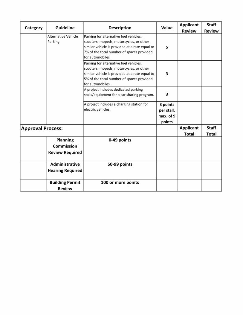
Category Guideline Description ValueApplicant
ReviewStaff
Review33% or more of the total dwelling units. 3020% or more of the total dwelling units. 1510% or more of the total dwelling units. 1033% or more of the total dwelling units. 815% or more of the total dwelling units 510% or more of the total dwelling units.
3
A minimum of 1500 square feet. 15A minimum of 1000 square feet 10A minimum of 500 Square feet
5
50% or more of the existing surface parking lot is covered by new buildings. 15
35% or more of the existing surface parking lot is covered by new buildings. 10
25% or more of the existing surface parking lot is covered by new buildings.
5
A new building that meets the standards of the TSA zoning district and replaces a building that does not meet the standards.
10
A project that includes replacing a nonconforming use with a use that is allowed in the TSA zoning district.
5
Removal of Billboards An existing billboard is legally removed by the developer as part of a redevelopment project.
10
The project utilizes a renewable energy source, such as geothermal heating, solar panels, or other similar system that is incorporated into the open space and capable of producing at least 25% of the buildings energy needs.
15
The project utilizes a roof design, such as a landscaped roof, that is intended to reduce energy use, storm drainage runoff or other similar sustainable policy of the City.
10
Building and Site Design
Mixed Income Housing: A project that includes affordable housing (available to those with 80% or less of the median household income of the City) for sale or
Redevelopment of Surface Parking Lots.
Redevelopment of Nonconforming Use or Noncomplying Building
Sustainable Site and Open Space Design
Community Serving Uses: Refer to the Transit Station Area Development Guidelines for qualifying uses.

Category Guideline Description ValueApplicant
ReviewStaff
ReviewThe project utilizes landscape designs and materials that conserves energy, reduces the urban heat island, conserves water, retains or reuses storm drainage or other similar sustainable policy of the City. Documentation must be provided to indicate how the project will incorporate this guideline.
5
Emerald 50Gold 40Silver 20
The project is capable of producing 100% of its power through renewable sources as documented by a licensed engineer.
50
The project is capable of producing 50% of its power through renewable sources as documented by a qualified, licensed engineer.
25
The project is capable of producing 25% of its power through renewable sources as documented by a qualified, licensed engineer.
10
The project is capable of producing 10% of its power through renewable sources as documented by a qualified, licensed engineer
5
The project is designed with passive, energy efficient features that are capable of reducing the energy needs of the building by at least 25%.
5
Architectural detailing is wrapped around all four sides.
20
Architectural detailing is wrapped around both side facades of a building, but not on the rear façade.
15
Local Register: New construction, major alterations and additions that are approved by the Historic Landmark Commission that include reuse of the site.
40
National Register: State Historic Preservation Office review and approval of projects with exterior alterations not locally designated and seeking federal tax credits.
20
360 Degree Architecture
Historic Preservation
Green Building: based on the ICC National Green Building Standard
Energy Efficiency
20
GJ0121
Typewritten Text
20

Category Guideline Description ValueApplicant
ReviewStaff
ReviewProjects that are adjacent to a local or national designated property that are compatible with the historic property through building mass and bulk, setbacks and design features as determined by the Planning Director
20
Local Register: Projects that receive administrative approval in accordance with Zoning Ordinance Section 21A.34.020.
5
Projects that add historically significant sites to the Salt Lake City Register of Cultural Resources if they qualify as defined in Zoning Ordinance Section 21A.34.
50
The entire street facing façade, excluding glazing, doors, and trim, is clad in durable, high quality materials as listed in the Transit Station Area Development Guidelines.
15
Other than glazing, doors and trim materials, projects that have a minimum of 50% of the street facing façade clad in durable, high quality building materials as listed in the Transit Station Area Development Guidelines.
10
When located on the corner of two intersecting streets, the primary entrance of the building addresses the corner by including a hinged, rounded, beveled, open bay, mitered orientation or similar entrance feature.
10
A corner building is designed with a visual emphasis placed on the corner to make the building more prominent. This may include additional height, a change in material, or change in architectural detail. 10
A rooftop of a building is used as a common space for the building occupants. 6
Corner Buildings
Rooftop Design and Use
Building Materials
6
GJ0121
Typewritten Text
6

Category Guideline Description ValueApplicant
ReviewStaff
ReviewA roof includes at least one of the following design features: 5 pointsTwo or more sloping planes if the roof is pitched;An arched or barrel vaulted design;A distinguishable cornice or parapet;Overhangs significant enough to create a shadow line;Variations in height of parapets of at least 2 feet.
5
Eyes on the Street and Public Spaces
Operable openings, balconies, verandas or other similar features on all levels of the building that face a public space and allow visibility into the public space.
5
Lighting A project that includes a lighting plan that accomplishes at least one of the following: Casts light from store fronts onto the sidewalk;Highlights unique architectural features of a building;Highlights artwork or unique landscape features.
6
A sign that is mounted perpendicular to the primary building façade and oriented to the pedestrian (projecting business storefront sign).
2
An awning or canopy sign that is integrated into the design of the building. 2
A monument sign that is integrated into the site and compatible with the building architecture.
2
A project includes a minimum of 15% of the total lot area.
15
A project includes a minimum of 10% of the total lot area.
10
A project includes a minimum of 5% of the total lot area.
5
A public space, regardless of size, that is located near a transit station and includes seating, art, protection from the elements or other feature intended to activate the space or make it comfortable (must be within 330 feet of transit station).
3
At least 4 street furnishings 3At least 3 street furnishings 2At least 2 street furnishings 1
Public Spaces and Plazas
Streetscape Amenities
Public Spaces
Signs
5
5
GJ0121
Typewritten Text
5
GJ0121
Typewritten Text
5

Category Guideline Description ValueApplicant
ReviewStaff
ReviewAt least 1% of the project budget is dedicated to public art.
8
At least 0.5% of the project budget is dedicated to public art.
4
A major piece of art work is incorporated into the project and is visible from a public space.
2
Projects that include a minimum six foot wide ADA accessible walkway through a parking lot that is separated from vehicle drive aisles.
4
Projects that include a minimum six foot wide ADA accessible sidewalk from private property to public open spaces.
4
The project includes lockers, changing rooms for cyclists and showers.
6
The project includes any bicycle amenity identified in the Bicycle Amenity section of the Transit Station Area Development Guidelines.
3
The project incorporates art into the design of the bicycle amenity. 3
The project is located within 750 feet, measured along the most direct, legal walking path.
8
The project is located within 1500 feet, measured along the most direct legal walking path.
4
Mid-block Walkways The project includes a walkway accessible to the public that is a minimum of 20 feet wide that connects through the property to a public space, such as park, trail or similar area and allows for the walkway to be continued on adjacent properties.
6
100% of the parking is in above grade structured or 75% in a below grade structure.
50
75% of the parking is in above grade structure or 50% in a below grade structure. 40
50% of the parking is in above grade structure or 25% in a below grade structure. 20
At least 50% of the parking is shared with other uses, whether on or off site.
15
At least 40% of the parking is shared with other uses, whether on or off site.
12
At least 25% of the parking is shared with other uses, whether on or off site.
8
Circulation
Public Artwork
Structured Parking
Shared Parking
Connections and Walkways
Bicycle Amenities
Access to Transit
Parking (see the Transit Station Area Development Guidelines for qualifying provisions related to this item)
3
50
GJ0121
Typewritten Text
3
GJ0121
Typewritten Text
50
Category Guideline Description ValueApplicant
ReviewStaff
ReviewParking for alternative fuel vehicles, scooters, mopeds, motorcycles, or other similar vehicle is provided at a rate equal to 7% of the total number of spaces provided for automobiles.
5
Parking for alternative fuel vehicles, scooters, mopeds, motorcycles, or other similar vehicle is provided at a rate equal to 5% of the total number of spaces provided for automobiles.
3
A project includes dedicated parking stalls/equipment for a car sharing program. 3
A project includes a charging station for electric vehicles.
3 points per stall, max. of 9
points
Approval Process: Applicant Total
Staff Total
Planning Commission
Review Required
0-49 points
Administrative Hearing Required
50-99 points
Building Permit Review
100 or more points
Alternative Vehicle Parking
GJ0121
Typewritten Text
101

13 PLNSUB2016-01000 and PLNSUB2017-00032
ATTACHMENT F: PROPERTY PHOTOGRAPHS
Street view image from the intersection of 200 S 1000 W
East view of alley and North abutting properties from 1000 W

14 PLNSUB2016-01000 and PLNSUB2017-00032
Southeast view of property and residences to the Northwest
Current conditions

15 PLNSUB2016-01000 and PLNSUB2017-00032
ATTACHMENT G: EXISTING CONDITIONS & ZONING
North Temple Boulevard 800 West Station Area Plan The proposed development is located within the North Temple Boulevard Plan Area. The North Temple Boulevard Plan was adopted by the Council on August 10th 2010. The Euclid Neighborhood is identified in the plan for transit station area mixed use, and an increase of residential density around the 800 West Station ranging from single family to 3-4 story multifamily developments. The current zoning reflects the plan through TSA-UN-T throughout the Euclid area North of the I-80/I-15 Interchange. The property to the North of the project is zoned RMF-35 and directly to the West is BP where a unique transition of Business Park Uses has occurred. The current zoning of TSA-UN-T is appropriate for the type of medium density residential development proposed. Adjacent Land Use The land uses surrounding the site include:
East: Single family residential West: Single family residential North: Single family residential South: Approximately 400 feet of roadway and Interstate right of way
Applicable General Zoning Standards:
Requirement TSA-UN-T Standards Proposed Development
Complies
Building Height
50’ Maximum 0’ Minimum
35’ Yes
Lot Size 2,500 sq ft min. 600-800 sq ft No, modification requested
Lot Width 40 ft of street frontage min. 317’ Yes Front/Corner Yard Setback
0' min. If provided 50% of façade within 5’
5’ Yes
Sideyard Setback
0' min. 25’ when adjacent to certain residential
2’ Yes
Rear Setback 0' min. 25’ when adjacent to certain residential
17’ No, modification requested
Building Stepback
1’ for every foot over 25’ at setback line
0’ No, modification requested to continue vertical façade within setback up to 35’
Open Space 10% of land area up to 2,500 square feet
5,900 sq ft Yes
Parking Requirement
Residential in Transition: 50% of required minimum for all uses 1.5 per dwelling unit maximum
24 Yes

16 PLNSUB2016-01000 and PLNSUB2017-00032
Applicable Design Standards: Standard Standard Proposed
Development Complies
a. Street wall Changes in plane, material, texture, etc. on facades greater than 30’
Brick and windows Yes
b. Ground floor materials
80% clad in durable materials 100% Yes
c. Ground floor glass
60% 40% for residential uses
10% on two street facing building ends
No, modification requested to be under 40% for two street facing non entrance facades
d.e. Building entrances
Minimum of 1 street facing entrance
1 per unit Yes
f. Parking structures
Below grade with residential uses <5’ above grade
4’ Yes
g. Mechanical equipment
Screened from public view Screened Yes
h. Service areas
Screened and 25’ from residential building
Screened and over 25’
Yes
Front Yard Landscaping
Trees every 25 feet. Shrubs every 2 feet
Will need to comply with Zoning comments
No

17 PLNSUB2016-01000 and PLNSUB2017-00032
ATTACHMENT H: ANALYSIS OF STANDARDS – PLANNED DEVELOPMENT
21a.55.050: Standards for Planned Developments: The planning commission may approve, approve with conditions, or deny a planned development based upon written findings of fact according to each of the following standards. It is the responsibility of the applicant to provide written and graphic evidence demonstrating compliance with the following standards:
Standard Finding Rationale A. Planned Development Objectives: The planned development shall meet the purpose statement for a planned development (section 21A.55.010 of this chapter) and will achieve at least one of the objectives stated in said section:
A. Combination and coordination of architectural styles, building forms, building materials, and building relationships; B. Preservation and enhancement of desirable site characteristics such as natural topography, vegetation and geologic features, and the prevention of soil erosion; C. Preservation of buildings which are architecturally or historically significant or contribute to the character of the city; D. Use of design, landscape, or architectural features to create a pleasing environment; E. Inclusion of special development amenities that are in the interest of the general public; F. Elimination of blighted structures or incompatible uses through redevelopment or rehabilitation; G. Inclusion of affordable housing with market rate housing; or H. Utilization of "green" building techniques in development.
Complies The applicant is complying with objectives A, D and E. These objectives involve a unique housing product with medium densities that offer single family living options. The proposed architecture of the proposed townhomes is unique in that if offers a housing type that is not common in the City. It also includes rooftop balcony/gardens, and an interior courtyard area that conceals underground parking. The front porches and balconies are also significant in activating the street. The proposed materials are of high quality and cover a majority of the buildings. The landscape plan and courtyard design creates an open space that may be used as semi-private community gathering location. Providing open space amenities with landscaping and gathering spaces is an environment that is desirable and supported in Citywide Plans. The inclusion of on street angled parking will benefit the project for visitor parking, but also be available to the general public and utilize large park strips that are often unused. This type of parking may also support home occupations or live work space.
B. Master Plan And Zoning Ordinance Compliance: The proposed planned development shall be:
1. Consistent with any adopted policy set forth in the citywide, community, and/or small area master plan and future land use map applicable to the site where the planned development will be located, and
2. Allowed by the zone where the planned development will be located or by another applicable provision of this title.
Complies 1. The proposed development is located in the North Temple Boulevard Plan area. Development opportunities have been identified for this area as mixed-use and medium density with appropriately designed residential uses on the ground floor. The proposed development closely matches what is called for in the plan.
2. Residential uses are allowed in the TSA-UN-T District.

18 PLNSUB2016-01000 and PLNSUB2017-00032
C. Compatibility: The proposed planned development shall be compatible with the character of the site, adjacent properties, and existing development within the vicinity of the site where the use will be located. In determining compatibility, the planning commission shall consider:
1. Whether the street or other means of access to the site provide the necessary ingress/egress without materially degrading the service level on such street/access or any adjacent street/access; 2. Whether the planned development and its location will create unusual pedestrian or vehicle traffic patterns or volumes that would not be expected, based on:
a. Orientation of driveways and whether they direct traffic to major or local streets, and, if directed to local streets, the impact on the safety, purpose, and character of these streets; b. Parking area locations and size, and whether parking plans are likely to encourage street side parking for the planned development which will adversely impact the reasonable use of adjacent property; c. Hours of peak traffic to the proposed planned development and whether such traffic will unreasonably impair the use and enjoyment of adjacent property.
3. Whether the internal circulation system of the proposed planned development will be designed to mitigate adverse impacts on adjacent property from motorized, nonmotorized, and pedestrian traffic;
4. Whether existing or proposed utility and public services will be adequate to support the proposed planned development at normal service levels and will be designed in a manner to avoid adverse impacts on adjacent land uses, public services, and utility resources;
5. Whether appropriate buffering or other mitigation measures,
Complies 1. The parking garages will be accessed by a public alley on the North side of the property, with only one access point on 1000 West. There is no anticipated adverse impact to the local street. The Transportation Division did not express any concerns regarding potential traffic impacts from the development. 2.a. The ingress/egress to the property will be served by the alley feeding onto a local street with ample capacity. 2b. The proposal includes angled parking to be located in the park strip and that will provide several more on street spaces than would be available from parallel parking. 2c. No impact is anticipated for the peak period and all collectors and arterials accessed by the applicable section of 1000 West are operating far below capacity. 3. The internal circulation of the property will be isolated to the alley for vehicles and new and improved sidewalks. The proposed circulation can only serve to improve the circulation of the site. 4. The development will require to upgraded utility infrastructure where determined to be necessary by the Public Utilities Department and other responsible entities in order to adequately provide service. No adverse impacts are expected from increased utility or public service use from the property. 5. The development is located in an area zoned for commercial and light industrial uses, and the surrounding properties near the site are either vacant or of uses that are more intense by nature such as the tow lot. No disturbances can be foreseen at this time which would warrant any mitigation.
19 PLNSUB2016-01000 and PLNSUB2017-00032
such as, but not limited to, landscaping, setbacks, building location, sound attenuation, odor control, will be provided to protect adjacent land uses from excessive light, noise, odor and visual impacts and other unusual disturbances from trash collection, deliveries, and mechanical equipment resulting from the proposed planned development; and
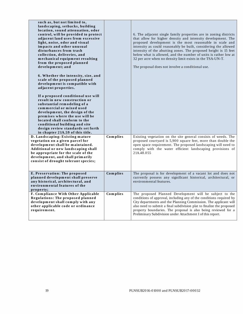
6. Whether the intensity, size, and scale of the proposed planned development is compatible with adjacent properties. If a proposed conditional use will result in new construction or substantial remodeling of a commercial or mixed used development, the design of the premises where the use will be located shall conform to the conditional building and site design review standards set forth in chapter 21A.59 of this title.
6. The adjacent single family properties are in zoning districts that allow for higher density and intensity development. The proposed development is the most reasonable in scale and intensity as could reasonably be built, considering the allowed intensity of the abutting zones. The proposed height is 15 feet below what is allowed, and the number of units is rather low at 32 per acre when no density limit exists in the TSA-UN-T. The proposal does not involve a conditional use.
D. Landscaping: Existing mature vegetation on a given parcel for development shall be maintained. Additional or new landscaping shall be appropriate for the scale of the development, and shall primarily consist of drought tolerant species;
Complies Existing vegetation on the site general consists of weeds. The proposed courtyard is 5,900 square feet, more than double the open space requirement. The proposed landscaping will need to comply with the water efficient landscaping provisions of 21A.48.055
E. Preservation: The proposed planned development shall preserve any historical, architectural, and environmental features of the property;
Complies The proposal is for development of a vacant lot and does not currently possess any significant historical, architectural, or environmental features.
F. Compliance With Other Applicable Regulations: The proposed planned development shall comply with any other applicable code or ordinance requirement.
Complies The proposed Planned Development will be subject to the conditions of approval, including any of the conditions required by City departments and the Planning Commission. The applicant will also need to submit a final subdivision plat to finalize the proposed property boundaries. The proposal is also being reviewed for a Preliminary Subdivision under Attachment I of this report.
20 PLNSUB2016-01000 and PLNSUB2017-00032
ATTACHMENT I: ANALYSIS OF STANDARDS – PRELIMINARY SUBDIVISION
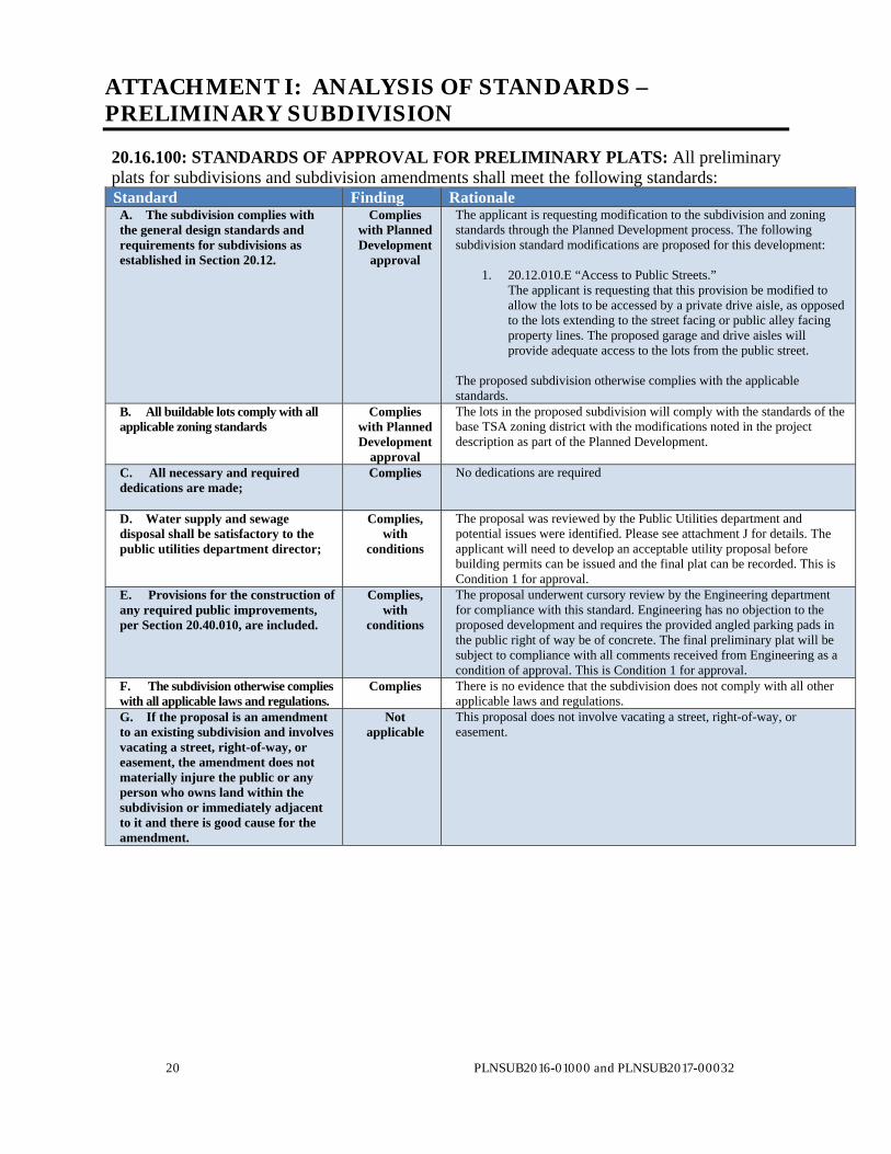
20.16.100: STANDARDS OF APPROVAL FOR PRELIMINARY PLATS: All preliminary plats for subdivisions and subdivision amendments shall meet the following standards: Standard Finding Rationale A. The subdivision complies with the general design standards and requirements for subdivisions as established in Section 20.12.
Complies with Planned Development
approval
The applicant is requesting modification to the subdivision and zoning standards through the Planned Development process. The following subdivision standard modifications are proposed for this development:
1. 20.12.010.E “Access to Public Streets.” The applicant is requesting that this provision be modified to allow the lots to be accessed by a private drive aisle, as opposed to the lots extending to the street facing or public alley facing property lines. The proposed garage and drive aisles will provide adequate access to the lots from the public street.
The proposed subdivision otherwise complies with the applicable standards.
B. All buildable lots comply with all applicable zoning standards
Complies with Planned Development
approval
The lots in the proposed subdivision will comply with the standards of the base TSA zoning district with the modifications noted in the project description as part of the Planned Development.
C. All necessary and required dedications are made;
Complies No dedications are required
D. Water supply and sewage disposal shall be satisfactory to the public utilities department director;
Complies, with
conditions
The proposal was reviewed by the Public Utilities department and potential issues were identified. Please see attachment J for details. The applicant will need to develop an acceptable utility proposal before building permits can be issued and the final plat can be recorded. This is Condition 1 for approval.
E. Provisions for the construction of any required public improvements, per Section 20.40.010, are included.
Complies, with
conditions
The proposal underwent cursory review by the Engineering department for compliance with this standard. Engineering has no objection to the proposed development and requires the provided angled parking pads in the public right of way be of concrete. The final preliminary plat will be subject to compliance with all comments received from Engineering as a condition of approval. This is Condition 1 for approval.
F. The subdivision otherwise complies with all applicable laws and regulations.
Complies There is no evidence that the subdivision does not comply with all other applicable laws and regulations.
G. If the proposal is an amendment to an existing subdivision and involves vacating a street, right-of-way, or easement, the amendment does not materially injure the public or any person who owns land within the subdivision or immediately adjacent to it and there is good cause for the amendment.
Not applicable
This proposal does not involve vacating a street, right-of-way, or easement.

21 PLNSUB2016-01000 and PLNSUB2017-00032
ATTACHMENT J: PUBLIC PROCESS AND COMMENTS
Public Notice, Meetings, Comments The following is a list of public meetings that have been held, and other public input opportunities, related to the proposed project:
Poplar Grove Community Council Presentation on January 25th, 2017 Open House on February 16th, 2017
Notice of Application: The planning staff held a public open house for the proposal on February 16th at the Tenth East Senior Center. The Planning division sent mailed notices out to properties within 350 feet and sent an e-mailed open house notice to affected community councils. Notice of the public hearing for the proposal included: Public hearing notice mailed on February 10, 2017. Public hearing notice posted on February 6, 2017 Public notice posted on City and State websites and Planning Division list serve on February 10, 2017. Public Input: The project was presented to the Poplar Grove Community Council by Bob Lund of NeighborWorks SLC on January 25th, 2017. The individuals in attendance inquired whether it would have affordable units, and how the project would affect property values. The question was also raised as to whether or not the applicant would improve the entire alley or just the segment behind the project. There was an individual who identified himself as the environmental chair of the Community Council who wanted to know how the project would address storm water runoff, and that they did not want the runoff ending up in the Jordan River or storm drains. Planning staff explained that on site reclamation is not required, but all comments would be passed on to the applicant. Planning staff also explained the process of approval and upcoming opportunities for additional input and comments. The conductor of the meeting asked if the audience was in favor and seemingly everyone in the room raised their hands. The project was presented for comments as a public open house held at the Tenth East Senior Center located at 237 South 1000 East on February 16th, 2017. The general comments received were supportive in nature and primarily inquisitive. One attendee, Brandon Felsted, who is a property owner on Euclid ave. had several concerns related to parking, alley maintenance, and blockage of the alley if people illegally park. He also voiced concerns and posed questions relating to changes according to the master plan and rezoning. These questions were addressed by sending him the staff report from the 2010 rezone, and reference to the North Temple Boulevard Plan. Three individuals signed in. The printed feedback material is attached below. No additional public comments have been received by staff at the time of this report.

1
Goates, Jonathan
From: Brandon felsted <[email protected]>Sent: Wednesday, February 15, 2017 4:57 PMTo: Goates, JonathanSubject: Concerns over proposed subdivision
Hi I received notice in the mail a few days ago for an open house regarding a proposed building project, your email was attached. I have a few questions regarding your project. first when did this zoning change from o RF 3500 to TSA-un? This new designation is concerning because there has not any notice that Euclid zoning changes have been discussed. Which lead to my second question Question 2 who has decided it's in the cities interest to fundamentally change the characteristics of a a well-established neighborhood furthermore when Urban renewal has happened conformed to the existing neighborhood. Question 3 I know the The cities Urban master plan has called for rezoning in the Gateway region why is such a dense neighborhood being proposed in a area that is plant for Less density? Question 4 why is the proposed development not conforming with existing medium density housing,. The Euclid neighborhood has six apartment complexes that are well-maintained they each have unique architectual value adding to this neighborhood each building has a private Courtyard and is well maintained parking is plentiful with spaces in front of the property and parking in the rear. The properties how mature trees and it's landscape is well maintained. These rentals bring up the neighborhood because they are always cared for which leads to my next question 5 the proposed properties will potentially have 16 separate owners so the plans show well-kept grass and tidy yards what will be done if they are not maintained? Question sex from our initial discussion the parking is limited and with the builders proposal to alter parking for Less space how will the builders plan to mitigate potentially 50 additional cars parking? Question 7 the proposed 16 buildings with three bedrooms upstairs and potentially three bedrooms in the basement how does the plans mitigate additional families moving into the basements of these units? Question 8 though the Allie way is public domain potentially 3 times the traffic will now travel down this alley what work has been done to mitigate the additional noise from the traffic? Question 9 what planning has been done for the Perpetual maintenance of this neighborhood, concerned with yards. Question 10 is there enough storage in the property or will people store stuff outside potentially being a fire hazard. Question 11 will the Trees of this neighborhood conform with Euclid? Thank you for taking the time to talk to me earlier today. I look forward to meeting and discussing these concerns with you tomorrow. Kind regards Brandon felsted 801-703-1757


22 PLNSUB2016-01000 and PLNSUB2017-00032
ATTACHMENT K: DEPARTMENT REVIEW COMMENTS
Fire (Kenney Christensen, 801-535-6619, [email protected])
Definitions: • FIRE AREA. The aggregate floor area enclosed and bounded by fire walls, fire barriers, exterior walls or horizontal assemblies of a building. Areas of the building not provided with surrounding walls shall be included in the fire area if such areas are included within the horizontal projection of the roof or floor next above. • FIRE APPARATUS ACCESS ROAD. A road that provides fire apparatus access from a fire station to a facility, building or portion thereof. This is a general term inclusive of all other terms such as fire lane, public street, private street, parking lot lane and access roadway. • FIRE LANE. A road or other passageway developed to allow the passage of fire apparatus. A fire lane is not necessarily intended for vehicular traffic other than fire apparatus. • GRADE PLANE. A reference plane representing the average of finished ground level adjoining the building at exterior walls. Where the finished ground level slopes away from the exterior walls, the reference plane shall be established by the lowest points within the area between the building and the lot line or, where the lot line is more than 6 feet from the building, between the building and a point 6 feet from the building. • REGISTERED DESIGN PROFESSIONAL. An architect or engineer, registered or licensed to practice professional architecture or engineering, as defined by the statutory requirements of the professional registration laws of the state (Utah DOPL) in which the project is to be constructed. Design Criteria: • IFC 104.9 Alternative materials and methods. The provisions of this code are not intended to prevent the installation of any material or to prohibit any method of construction not specifically prescribed by this code, provided that any such alternative has been approved. The fire code official is authorized to approve an alternative material or method of construction where the fire code official finds that the proposed design is satisfactory and complies with the intent of the provisions of this code, and that the material, method or work offered is, for the purpose intended, at least the equivalent of that prescribed in this code in quality, strength, effectiveness, fire resistance, durability and safety. For any occupancy the following is needed: • Provide record of certified address assigned by the city engineer office; all drawing sheets shall contain the certified address in the title block including the unit or suite number if applicable. The application for permit shall have the same certified address, unit or suite number. • Fire hydrants shall be within 400 feet (600 feet; parking lots & residential) of the structure or facility. • If required; FDC shall be installed on the certified address side of the structure and within 100 feet of a fire hydrant located near an approved fire department access road. • FDC and fire hydrants shall be unobstructed and have a minimum 3 feet clearance. Immediate access to fire department connections and hydrants shall be maintained at all times and without obstruction by fences, bushes, trees, walls or any other fixed or moveable object. Access to fire department connections shall be approved by the fire official. • Approved fire apparatus access roads shall be provided for every facility, building or portion of a building hereafter constructed or moved into or within the jurisdiction. The fire apparatus access road shall comply with the requirements of 2015 IFC and shall extend to within 150 feet of all portions of the facility and all portions of the exterior walls of the first story of the building as measured by an approved route around the exterior of the building or facility. If the structure is built on property line then an Alternate Means & Method may be applied for. • The angles of approach and departure for fire apparatus access roads shall be within the limits established by the fire code official based on the fire department’s apparatus (Fire apparatus access roads shall not exceed 10 percent in grade). Traffic calming devices shall be prohibited unless approved by the Fire Prevention Bureau (AM&M Agreement). • Fire department access roads shall be a minimum of *26 ft. clear width (exclusive of shoulders) and a clear height of 13 ft. 6 inches. Fire department access roads shall be design HS20 with turning radius of 45 ft. outside and 20 ft. inside. The access road shall not have a dead end greater than 150 ft. Fire access roads shall be capable of supporting vehicle loading (88,000 LBS) under all weather conditions.

23 PLNSUB2016-01000 and PLNSUB2017-00032
*{If the structure is less than 30 feet tall the access road can be reduced to a minimum 20 ft. clear width (exclusive of shoulders) when approved by the Fire Prevention Bureau, NO fire truck aerial access would be allowed, AM&M agreement would be required with alternative design.} • The aerial access road shall have no utility lines over the road or between the structure and the access road; where the vertical distance between the grade plane and the highest roof surface exceeds 30 feet, approved aerial fire apparatus access roads shall be provided (the highest roof surface shall be determined by measurement to the eave of a pitched roof, the intersection of the roof to the exterior wall, or the top of parapet walls, whichever is greater). • When two access roads are required then one of the roads shall not be closer than 15 ft. to the structure and greater than 30 ft. from the structure. • Gates or other approved barricades across fire apparatus access roads, trails or other access ways, not including public streets, alleys or highways. Electric gate operators, where provided, shall be listed in accordance with UL 325. Gates intended for automatic operation shall be designed, constructed and installed to comply with the requirements of ASTM F 2200 and shall be approved by the fire official.
Engineering (Scott Weiler, 801-535-6159, [email protected]) Engineering does not have any comment on the reasons for the planned development but offers the following comments: If cut back parking is to be installed for the project frontage of 1000 West and 200 South (as indicated on the plans), the developer should budget for it being constructed with concrete. The proposed cut back parking layout in 200 South would require the relocation of the existing street light. The existing alley that runs along the north side of the proposed development is a public alley. A certified address will be issued upon request. 1002 W. 200 South will not be the certified address, as it is too low of a number. Transportation (Michael Barry, 801-535-7147, [email protected]) Off street parking requirements appear to have been met. Public way improvements regarding 45 degree angle parking are not required; additional information and review may be needed, including an assessment of parking needs, streetscape design, etc. The location of the bike racks is not optimal; recommend further review to find a more suitable location. Additional detail including bike rack type, dimensions and spacing should be provided. Public Utilities (Jason Draper, 801-483-6751, [email protected]) There is a 6” water main in 200 South. This may need to be upsized to provide adequate fire flow. There is a hydrant on 200 South in front of the property. There is sewer in 200 South and in the alley North of the property. A Utility plan will be required. Water, sewer and drainage will need to be managed by a community home owners association. Refer to DRT notes from 11/10/2016 and 10/19/2016 Zoning (Greg Mikolash, 801-535-6181, [email protected]) TSA-UN-T zone. All buildings and parking garage must be behind the 25 foot side yard setback on the north. - Provide parking calculations per 21A.44 (the minimum is 50% of the Table 21A.44.030 and the maximum is 1 1/2 stalls per unit). -Tandem parking is not allowed unless approved by the Transportation Department. - Project must comply with all requirements of 21A.26.078 (Transit Station Overlay District), including the design standards of section J. - Complete and receive approval from the Planning Division for the TSA score. - Note that exterior stairs may only encroach beyond the property lines into the public way with a commercial lease agreement approved by the city's Real Estate Services Division. - It will be necessary to provide a Landscape Plan per the requirements of 21A.48. - It will be necessary to provide an Impact Fee worksheet. - Provide a Recycling Collection Station per 21A.36.250.; such stations shall be placed in a manner as to not interfere with traffic and easily accessed by trash pick-up/recycling vehicles.
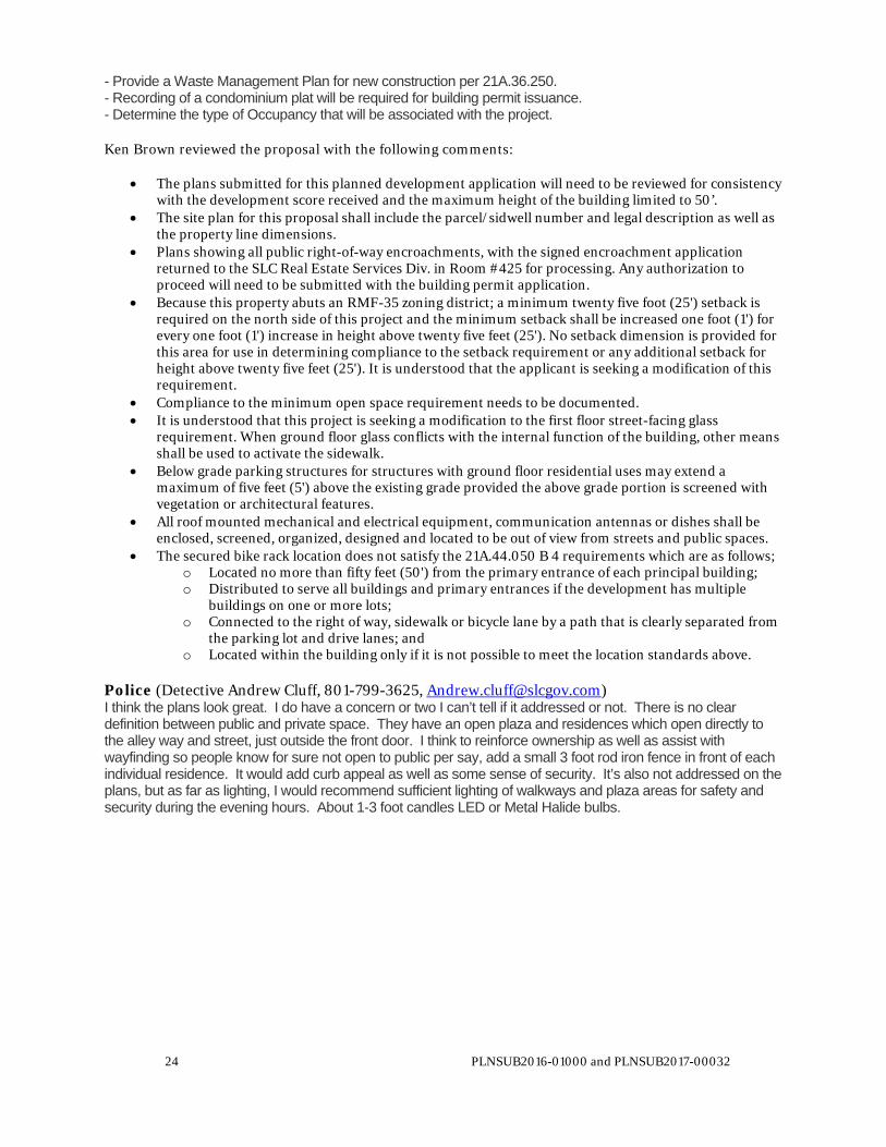
24 PLNSUB2016-01000 and PLNSUB2017-00032
- Provide a Waste Management Plan for new construction per 21A.36.250. - Recording of a condominium plat will be required for building permit issuance. - Determine the type of Occupancy that will be associated with the project. Ken Brown reviewed the proposal with the following comments:
The plans submitted for this planned development application will need to be reviewed for consistency with the development score received and the maximum height of the building limited to 50’.
The site plan for this proposal shall include the parcel/sidwell number and legal description as well as the property line dimensions.
Plans showing all public right-of-way encroachments, with the signed encroachment application returned to the SLC Real Estate Services Div. in Room #425 for processing. Any authorization to proceed will need to be submitted with the building permit application.
Because this property abuts an RMF-35 zoning district; a minimum twenty five foot (25') setback is required on the north side of this project and the minimum setback shall be increased one foot (1') for every one foot (1') increase in height above twenty five feet (25'). No setback dimension is provided for this area for use in determining compliance to the setback requirement or any additional setback for height above twenty five feet (25'). It is understood that the applicant is seeking a modification of this requirement.
Compliance to the minimum open space requirement needs to be documented. It is understood that this project is seeking a modification to the first floor street-facing glass
requirement. When ground floor glass conflicts with the internal function of the building, other means shall be used to activate the sidewalk.
Below grade parking structures for structures with ground floor residential uses may extend a maximum of five feet (5') above the existing grade provided the above grade portion is screened with vegetation or architectural features.
All roof mounted mechanical and electrical equipment, communication antennas or dishes shall be enclosed, screened, organized, designed and located to be out of view from streets and public spaces.
The secured bike rack location does not satisfy the 21A.44.050 B 4 requirements which are as follows; o Located no more than fifty feet (50') from the primary entrance of each principal building; o Distributed to serve all buildings and primary entrances if the development has multiple
buildings on one or more lots; o Connected to the right of way, sidewalk or bicycle lane by a path that is clearly separated from
the parking lot and drive lanes; and o Located within the building only if it is not possible to meet the location standards above.
Police (Detective Andrew Cluff, 801-799-3625, [email protected]) I think the plans look great. I do have a concern or two I can’t tell if it addressed or not. There is no clear definition between public and private space. They have an open plaza and residences which open directly to the alley way and street, just outside the front door. I think to reinforce ownership as well as assist with wayfinding so people know for sure not open to public per say, add a small 3 foot rod iron fence in front of each individual residence. It would add curb appeal as well as some sense of security. It’s also not addressed on the plans, but as far as lighting, I would recommend sufficient lighting of walkways and plaza areas for safety and security during the evening hours. About 1-3 foot candles LED or Metal Halide bulbs.

25 PLNSUB2016-01000 and PLNSUB2017-00032
ATTACHMENT L: POTENTIAL MOTIONS
Potential Motions
Staff Recommendation: Staff recommends the following motion: Based on the information in the staff report, public testimony, and discussion by the Planning Commission, I move that the Planning Commission approve petitions PLNSUB2016-01000 and PLNSUB2017-00032, regarding the Euclid Corners Townhomes Planned Development and Preliminary Subdivision request. In order to comply with the applicable standards, the following conditions of approval apply:
1. The applicant shall comply with all other Department/Division conditions provided to the applicant.
2. All other applicable zoning standards not modified by the Planned Development approval shall apply to the development.
3. The applicant shall follow through with a Real Estate Services to obtain a revocable permit for steps in the public right-of-way.
4. The section of the alley adjacent to the property will be have posted no parking signs. 5. The applicant will submit a Final Subdivision plat for the project with private infrastructure
cost disclosures within 18 months of Preliminary Subdivision approval. 6. Final approval authority for the development shall be delegated to Planning staff based on the
applicant’s compliance with the standards and conditions of approval as noted within this staff report.
Not Consistent with Staff Recommendation: (Planned Development and Preliminary Subdivision) Based on the testimony, plans presented and the following findings, I move that the Planning Commission deny the petition PLNPCM2016-01000 and PLNSUB2017-00032 Planned Development and Preliminary Subdivision request due to the following standard(s) that are not being complied with: (The Planning Commission shall make findings on the Planned Development and Preliminary Subdivision standards and specifically state which standard or standards are not being complied with. Please see Attachment H for applicable standards.)