10 th Eco-Junior-Expert Project Human activity and Its impact on the environment Group III Flood...
21
10 th Eco-Junior-Expert Project Human activity and Its impact on the environment Group III Flood Control Measures
-
Upload
turner-parmalee -
Category
Documents
-
view
218 -
download
1
Transcript of 10 th Eco-Junior-Expert Project Human activity and Its impact on the environment Group III Flood...

10th Eco-Junior-Expert ProjectHuman activity and Its impact on the
environment
Group III
Flood Control Measures

Names and nations
• Student from Poland: Zawistowski Aleksy, Wiecheć Bartlomiej, Dziadek Michal, Chrapek
Pawel
• Student from Austria: Auer Theresa, Schlager David, Taschl Ines
• Student from Czech Republic: Formánková Andrea, Háva Lukáš, Ištok Tomáš, Poborská Anna, Sokolík Jakub, Šimánková Eva, Urbanová Zuzana, Krebsová Lenka, Hruška Martin, Nováková Tereza, Novotná Dagmar, Novotná Tereza
• Student from Hungary: Nagy Alex, Mészáros Richárd, Nagy Gábor, Kóder Kinga

Task
• Measuring the flow rate of different rivers
• The Lužnice River
• The Nežárka River
• The Blatský Brook

Floods

Flood control measures • As a prevention against floods are used
river channel reconstruction and the environs.
• Two alternative methods exist: mobile and fixed barrier.
• Dry polder Krkavec• Polder is dry reservoir , which retains high
water. • Two variants of the construction of dry
polder are decided.

Variant 1• Culmination flow Decreasing
of the effect
• Twenty years floodQ20 = 189 m3/s → 51 %
• Fifty years floodQ50 = 253 m3/s → 55%
• One hundred years floodQ100 = 315 m3/s → 55%

Variant 2• Culmination flow Decreasing
of the effect• Twenty years flood
Q20 = 189 m3/s → 24 %
• Fifty years flood
Q50 = 253 m3/s → 14%
• One hundred years floodQ100 = 315 m3/s → 9%

• Calculation of revolutions in time
• Calculation of the speed of the water flow
• Making profiles of the rivers
Calculation of data

How we measured
• Special instrument: current meter
• Method: measure width of the river Allocation Measure flow rate Calculation


Results of the Nežárka river
Profile of the river
Rotations per minute
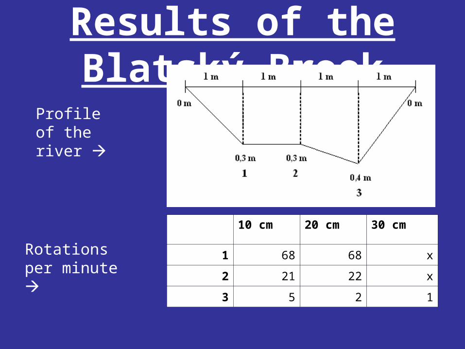
Results of the Blatský Brook
10 cm 20 cm 30 cm
1 68 68 x
2 21 22 x
3 5 2 1
Profile of the river
Rotations per minute
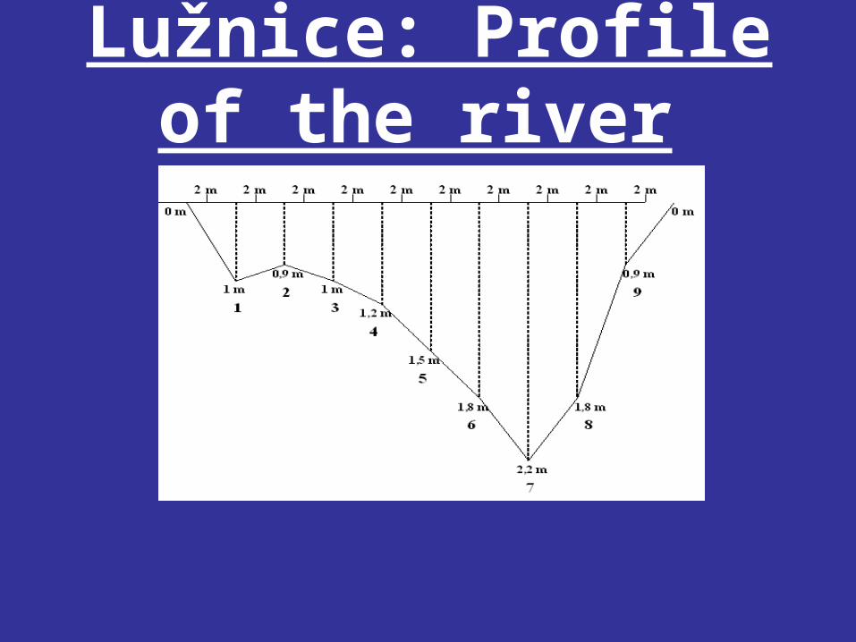
Lužnice: Profile of the river

Lužnice: Rotations per minute
Measuring Point
1 2 3 4 5 6 7 8 9
20 cm 0 0 0 0 4 3 3 0 0
40 cm 0 5 4 5 6 5 0 1 0
60 cm 0 13 10 11 12 9 2 2 0
80 cm 0 8 8 0 5 5 6 7 0
100 cm x x x 10 7 4 0 5 x
120cm x x x x 10 8 6 6 x
140 cm x x x x x 9 8 1 x
160cm x x x x x x 10 x x
180cm x x x x x x 11 x x
200 cm x x x x x x 10 x x
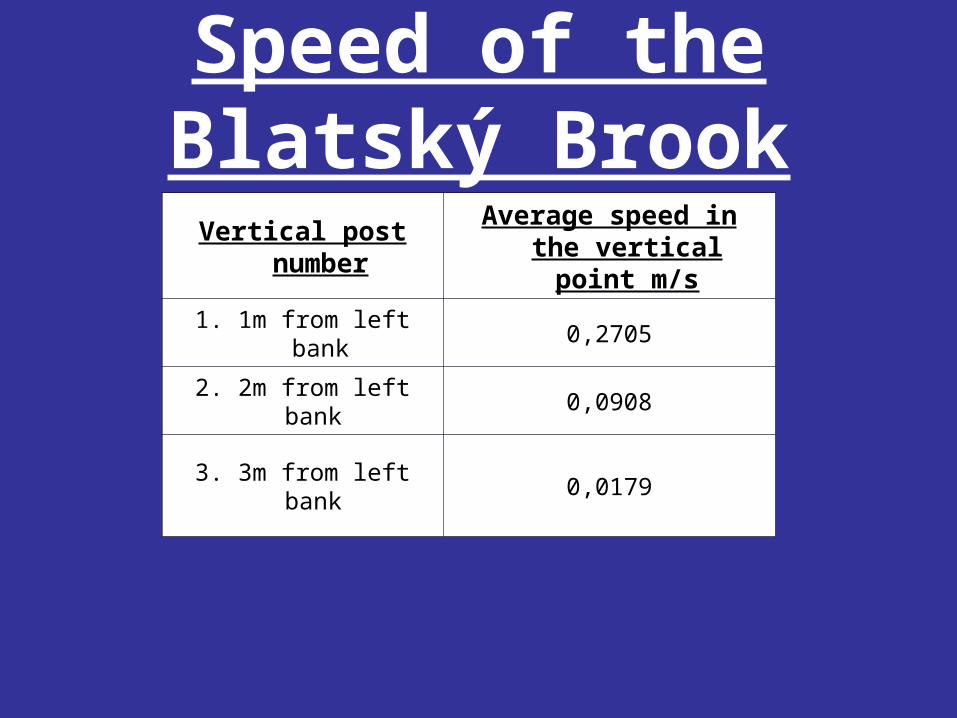
Speed of the Blatský Brook
Vertical post number
Average speed in the vertical point m/s
1. 1m from left bank 0,2705
2. 2m from left bank 0,0908
3. 3m from left bank 0,0179

Vertical post number
Average speed in the vertical point m/s
1. 2m from right bank 0,1263
2. 4m from right bank 0,5582
3. 6m from right bank 0,4009
4. 8m from right bank 0,52165
5. 10m from right bank 0,6989
6. 12m from right bank 0,7316
7. 14m from right bank 0,5024
8. 16m from rigth bank 0,3567
Speed of the Nežárka river

Speed of the Lužnice riverVertical post number
Average speed in the vertical point
1. 2m from left bank 0
2. 4m from left bank 0,023219
3. 6m from left bank 0,0232
4. 8m from left bank 0,0219
5. 10m from left bank 0,0309
6. 12m from left bank 0,0409
7. 14m from left bank 0,0256
8. 16m from left bank 0,01889
9. 18m from left bank 0
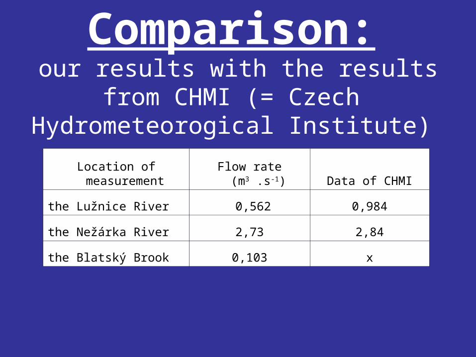
Comparison: our results with the results from CHMI (= Czech Hydrometeorogical Institute)
Location of measurement Flow rate (m3 .s-1) Data of CHMI
the Lužnice River 0,562 0,984
the Nežárka River 2,73 2,84
the Blatský Brook 0,103 x

Summary• Our results are coresponding with average
rates meassured by CHMI.• In 2002, the high water striked also Veselí nad
Lužnicí and this flood was the most severe flood recorded in the history. During the floods 415 houses were flooded (that is, 40 % of the area of this city was flooded). In Veselí nad Lužnicí the floods repeated in 2006.

Flood control measures
• In Veselí nad Lužnicí flood control measures will be implemented in 2009 and this project will be finished in 2011.
• As a prevention against floods are used river channel reconstruction and the environs. Two alternative methods exist:mobile and fixed barrier.
• The mobile barriers are installed just before the flood starts. The mobile barriers are constructed from sand-bags and mobile dikes.
• The fixed barriers are firmly connected to bedrock.

Thank you for your
attention…