1.0 SUBSURFACE CONDITIONS - … Park... · The CPTu tests were conducted in accordance with ASTM...
16
WPC, A Terracon Company 1450 Fifth Street West North Charleston, SC 29405 P [843] 884 1234 F [843] 884 9234 wpceng.com terracon.com April 26, 2011 Cooper River Partners 1588 Bushy Park Road Goose Creek, SC 29445 Attn: Mr. Marc Fetten O: (843) 820-6139 M: (412) 726-3331 E: [email protected] Re: Geotechnical Services New Development Subject Property Bushy Park Industrial Complex Goose Creek, SC WPC Project EN115023 Dear Mr. Fetten: As requested, WPC A Terracon Company (WPC) has completed the field investigation for the potential new development in the Bushy Park Industrial Complex in Goose Creek, South Carolina. The subject property is generally located northeast of the existing industrial complex. No information about the potential development has been provided at this time. As requested, WPC performed five (5) Cone Penetration Test (CPT) Soundings along the southern portion of the A-A cross section as shown in the attached test location plan. The CPT’s were advanced to a termination depth of 30 feet. Adjacent to each sounding, a Hand Auger Boring (HAB) was conducted to a depth of 4 feet. These soundings and borings were performed to gather information on the subsurface profile at the subject property. The following sections present an overview of the results. 1.0 SUBSURFACE CONDITIONS 1.1 Area Geology 1.1.1 South Carolina Geology The rock and soil deposits of South Carolina have been formed by geological forces over the past several hundred million years. The result of erosion and deposition of sediments over this time frame have created a complex geological framework that is still not fully understood today. However, if we simplify the geological features of our state, we can divide South
Transcript of 1.0 SUBSURFACE CONDITIONS - … Park... · The CPTu tests were conducted in accordance with ASTM...
WPC, A Terracon Company 1450 Fifth Street West North Charleston, SC 29405 P [843] 884 1234 F [843] 884 9234 wpceng.com terracon.com
April 26, 2011 Cooper River Partners 1588 Bushy Park Road Goose Creek, SC 29445 Attn: Mr. Marc Fetten O: (843) 820-6139 M: (412) 726-3331 E: [email protected] Re: Geotechnical Services
New Development Subject Property Bushy Park Industrial Complex Goose Creek, SC WPC Project EN115023
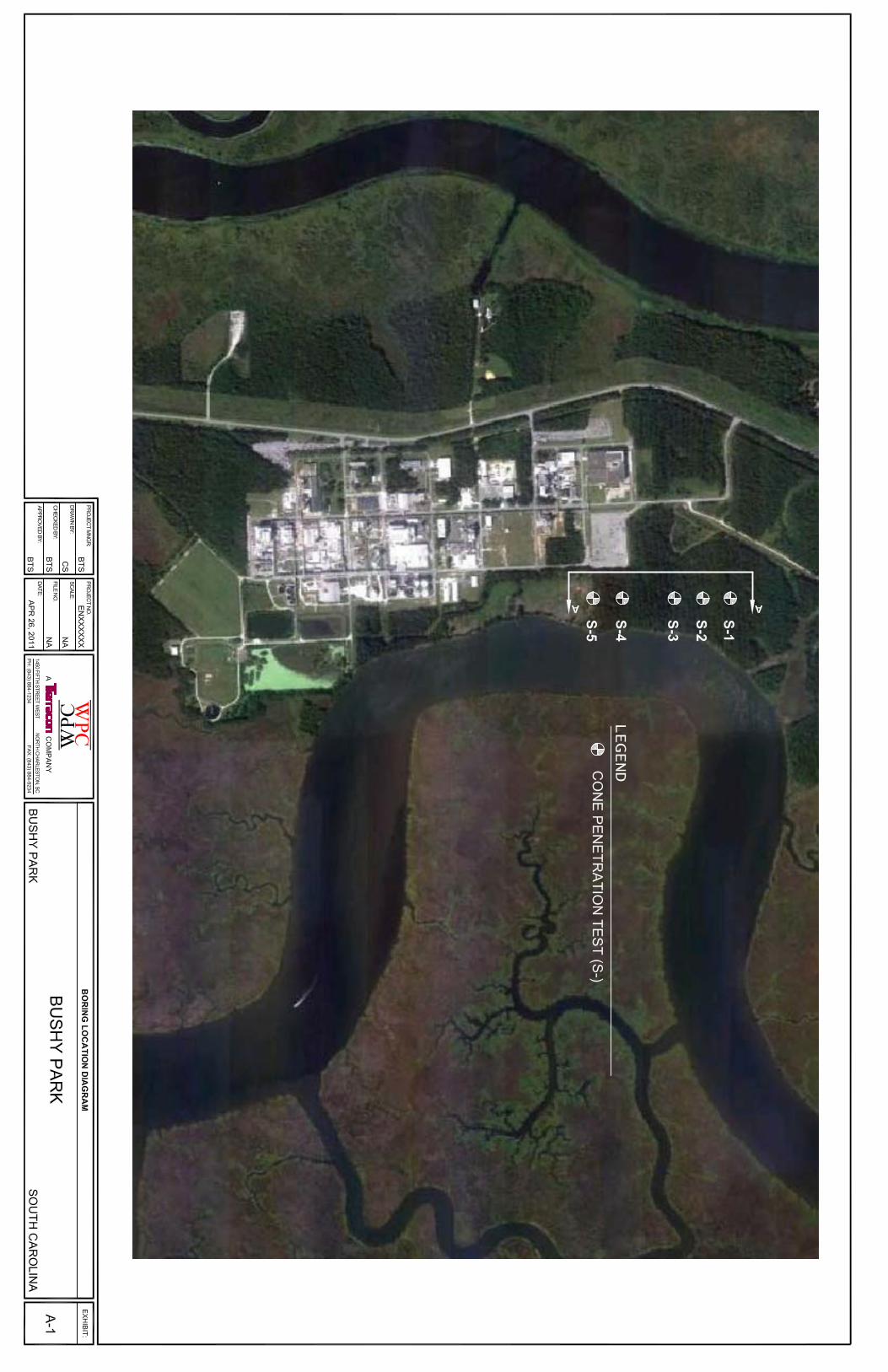
Dear Mr. Fetten: As requested, WPC A Terracon Company (WPC) has completed the field investigation for the potential new development in the Bushy Park Industrial Complex in Goose Creek, South Carolina. The subject property is generally located northeast of the existing industrial complex. No information about the potential development has been provided at this time. As requested, WPC performed five (5) Cone Penetration Test (CPT) Soundings along the southern portion of the A-A cross section as shown in the attached test location plan. The CPT’s were advanced to a termination depth of 30 feet. Adjacent to each sounding, a Hand Auger Boring (HAB) was conducted to a depth of 4 feet. These soundings and borings were performed to gather information on the subsurface profile at the subject property. The following sections present an overview of the results.
1.0 SUBSURFACE CONDITIONS 1.1 Area Geology 1.1.1 South Carolina Geology The rock and soil deposits of South Carolina have been formed by geological forces over the past several hundred million years. The result of erosion and deposition of sediments over this time frame have created a complex geological framework that is still not fully understood today. However, if we simplify the geological features of our state, we can divide South
Geotechnical Services New Development Subject Property ■ Bushy Park Industrial Complex Goose Creek, South Carolina ■ April 26, 2011 ■ WPC Project No. EN115023
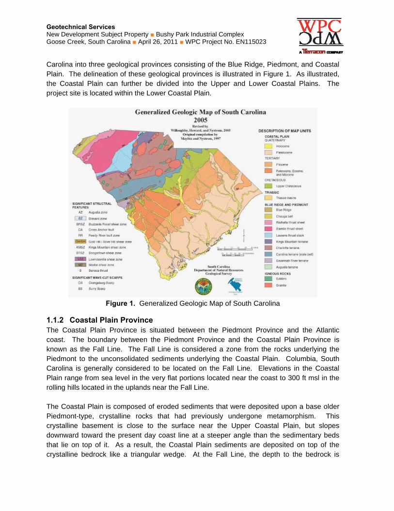
Carolina into three geological provinces consisting of the Blue Ridge, Piedmont, and Coastal Plain. The delineation of these geological provinces is illustrated in Figure 1. As illustrated, the Coastal Plain can further be divided into the Upper and Lower Coastal Plains. The project site is located within the Lower Coastal Plain.
Figure 1. Generalized Geologic Map of South Carolina
1.1.2 Coastal Plain Province The Coastal Plain Province is situated between the Piedmont Province and the Atlantic coast. The boundary between the Piedmont Province and the Coastal Plain Province is known as the Fall Line. The Fall Line is considered a zone from the rocks underlying the Piedmont to the unconsolidated sediments underlying the Coastal Plain. Columbia, South Carolina is generally considered to be located on the Fall Line. Elevations in the Coastal Plain range from sea level in the very flat portions located near the coast to 300 ft msl in the rolling hills located in the uplands near the Fall Line. The Coastal Plain is composed of eroded sediments that were deposited upon a base older Piedmont-type, crystalline rocks that had previously undergone metamorphism. This crystalline basement is close to the surface near the Upper Coastal Plain, but slopes downward toward the present day coast line at a steeper angle than the sedimentary beds that lie on top of it. As a result, the Coastal Plain sediments are deposited on top of the crystalline bedrock like a triangular wedge. At the Fall Line, the depth to the bedrock is
Geotechnical Services New Development Subject Property ■ Bushy Park Industrial Complex Goose Creek, South Carolina ■ April 26, 2011 ■ WPC Project No. EN115023
relatively small. However, as you approach the present day coast line, the depth to crystalline bedrock increases to a distance of over 3,000 feet. Some erosion occurs in the Upper Coastal Plain, however large portions of the Lower Coastal Plain have poorly drained soils. The soils of the Upper Coastal Plain are composed mainly of sand and clay sediments that were derived from the erosion of the rocks of the Piedmont Province. Alluvial sediments along streams and rivers have accumulated in recent geologic time and as a result, extensive swamps adjoin the rivers of the Lower Coastal Plain. The Lower Coastal Plain sediments consist of recent alluvial deposits that cover older marine deposits. It is typical to encounter layers of limestone and/or Marl in the Lower Coastal Plain.
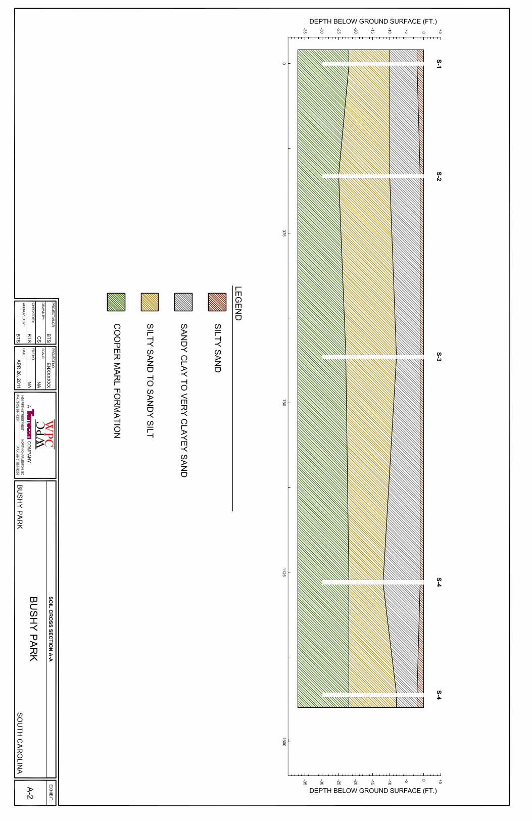
1.2 Typical Soil Profile Based on the results of our soil testing, subsurface conditions on the project site can be generalized as follows: Table 3. Generalized Subsurface Profile
Description Approximate Depth to
Bottom of Soil Stratum
Material Encountered Estimated SPT
N60
Stratum 1 1 feet Loose to Medium Dense Silty SAND 5 to 10
Stratum 2 10 feet Stiff to Very Stiff Sandy CLAY to
Medium Dense Clayey SAND 15 to 40
Stratum 3 22 feet Loose to Medium Dense Silty SAND
to Sandy SILT 5 to 15
Stratum 4 30 feet (termination of
deepest sounding) Stiff Silty Clay to Sandy Silt (Cooper
Marl Formation3) 12 to 15
1. SPT N (blow count) estimated from boring logs and correlations with CPT tip and friction resistance.
2. The Cooper Marl Formation (CMF) is an Eocene to Oligocene aged deposit that underlies the Charleston, SC area. The CMF is typically 100 to 200 feet thick and is usually considered the basement layer for geotechnical foundation design.
Conditions encountered at each sounding location are indicated on the individual sounding logs attached. The logs graphically illustrate the relative strength of the soils encountered and provide an approximate soil stratigraphy. The soil types indicated on the CPT sounding logs are estimated from currently accepted correlations between tip, side, and porewater pressure measurements. Stratification lines on the logs represent approximate boundaries between soil types based on visual examination and behavioral characteristics.
1.3 Groundwater Groundwater was estimated at a depth of approximately 5 to 6 feet below the ground surface. The groundwater depth was estimated by calculating the hydrostatic line (height of water below the ground surface) on the penetration porewater pressure (U) graph in the CPT Logs. Groundwater levels tend to fluctuate with seasonal and climatic variations, as well as with

Geotechnical Services New Development Subject Property ■ Bushy Park Industrial Complex Goose Creek, South Carolina ■ April 26, 2011 ■ WPC Project No. EN115023
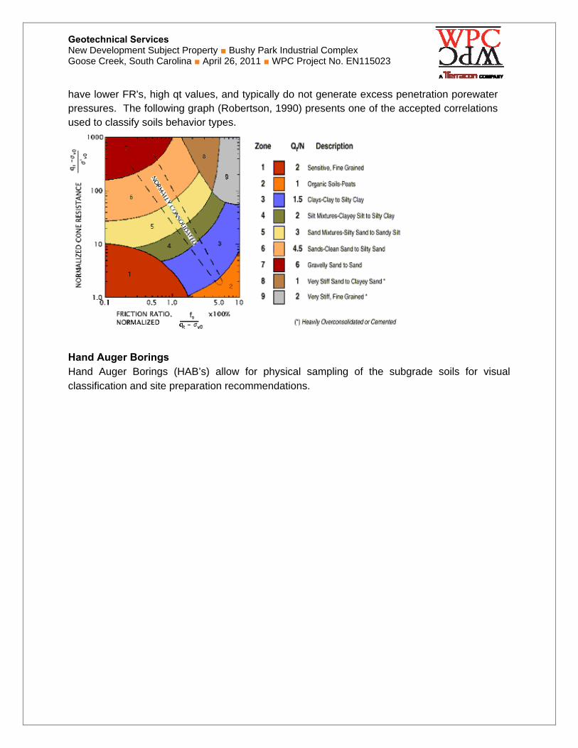
Field Exploration Description Overview The boring locations were chosen by WPC personnel and located in the field using scaled drawings and landmarks. The locations as shown in the Exploration Location Plan should be considered accurate only to the degree implied by the means and methods used to define them. Cone Penetration Testing The Cone Penetration Test (CPT) hydraulically pushes an instrumented cone through the soil while continuous readings are recorded to a portable computer. The instrumented cone has a cross-sectional area of 10 square centimeters (cm²) with a 60° conical tip. The cone is advanced through the ground at a constant rate of 2 centimeters per second (2 cm/sec). No soil samples are gathered through this subsurface investigation technique. However, insitu measurements of tip and side resistance and porewater pressure are taken every 2 centimeters (approximately 1 inch). Porewater pressure measurements are taken directly behind the tip, while a load cell located above the cone tip takes side friction measurements. These measurements can be correlated to various soil index properties for geotechnical design. The CPTu tests were conducted in accordance with ASTM D5778 “Standard Test Method for Performing Electronic Friction Cone and Piezocone Penetration Testing of Soils”. Cone Penetration Classification The tip resistance (qc) is measured as the maximum force over the projected area of the tip. It is a point stress related to the bearing capacity of the soil. The measured qc must be corrected for porewater pressure effects (Lunne et al, 1997), especially in clays and silts where porewater pressures typically vary greatly from hydrostatic. This corrected value is known as qt,, which is reported in the Piezocone Penetration Logs. The u2 position element is required for the measurement of penetration porewater pressures and the correction of tip resistance. The sleeve friction (fs) is used as a measure of soil type and can be expressed by friction ratio: FR = fs/qt. The estimated stratigraphic profiles included in the Piezocone Penetration Logs are based on relationships between qt, fs, and U2. The normalized friction ratio (FRN) is calculated by using:
%100'
vot
sN q
fFR
and is indicative of soil behavior and is used to classify the soil behavior type. Typically, cohesive soils, such as plastic silts and clays, have high FR values, low qt values, and generate large excess penetration porewater pressures. Cohesionless soils, such as sands,
Geotechnical Services New Development Subject Property ■ Bushy Park Industrial Complex Goose Creek, South Carolina ■ April 26, 2011 ■ WPC Project No. EN115023
have lower FR's, high qt values, and typically do not generate excess penetration porewater pressures. The following graph (Robertson, 1990) presents one of the accepted correlations used to classify soils behavior types.
Hand Auger Borings Hand Auger Borings (HAB’s) allow for physical sampling of the subgrade soils for visual classification and site preparation recommendations.
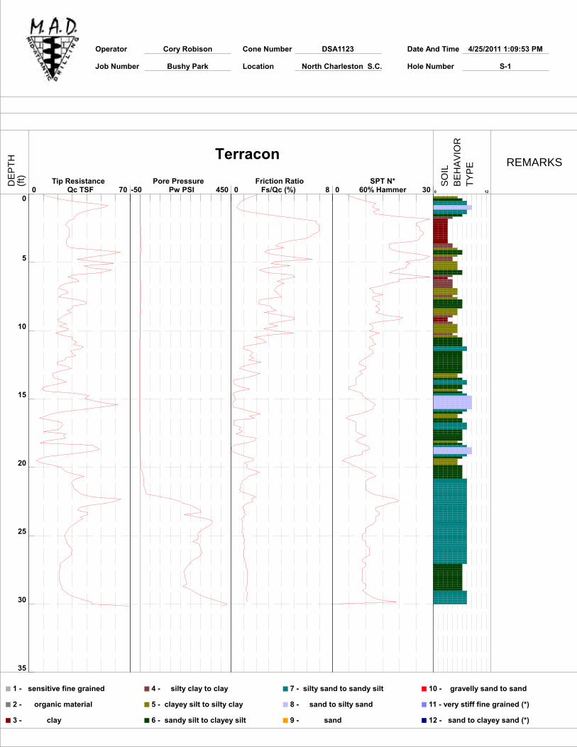
Operator Cory Robison Cone Number DSA1123 Date And Time 4/25/2011 1:09:53 PM
Job Number Bushy Park Location North Charleston S.C. Hole Number S-1
0
5
10
15
20
25
30
35
0 70 Tip Resistance
Qc TSF -50 450 Pore Pressure
Pw PSI 0 8 Friction Ratio Fs/Qc (%) 0 30
SPT N*60% Hammer 0 12
1 - sensitive fine grained
2 - organic material
3 - clay
4 - silty clay to clay
5 - clayey silt to silty clay
6 - sandy silt to clayey silt
7 - silty sand to sandy silt
8 - sand to silty sand
9 - sand
10 - gravelly sand to sand
11 - very stiff fine grained (*)
12 - sand to clayey sand (*)
TerraconREMARKS
DE
PT
H(f
t)
SO
ILB
EH
AV
IOR
TY
PE
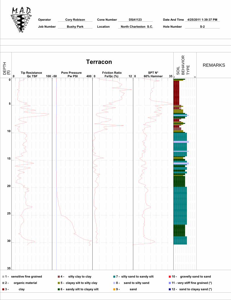
Operator Cory Robison Cone Number DSA1123 Date And Time 4/25/2011 1:39:37 PM
Job Number Bushy Park Location North Charleston S.C. Hole Number S-2
0
5
10
15
20
25
30
35
0 100 Tip Resistance
Qc TSF -50 400 Pore Pressure
Pw PSI 0 12 Friction Ratio Fs/Qc (%) 0 35
SPT N*60% Hammer 0 12
1 - sensitive fine grained
2 - organic material
3 - clay
4 - silty clay to clay
5 - clayey silt to silty clay
6 - sandy silt to clayey silt
7 - silty sand to sandy silt
8 - sand to silty sand
9 - sand
10 - gravelly sand to sand
11 - very stiff fine grained (*)
12 - sand to clayey sand (*)
TerraconREMARKS
DE
PT
H(f
t)
SO
ILB
EH
AV
IOR
TY
PE
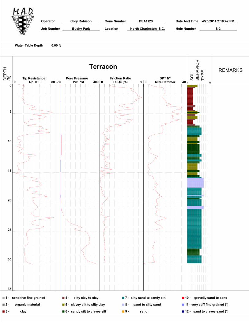
Operator Cory Robison Cone Number DSA1123 Date And Time 4/25/2011 2:10:42 PM
Job Number Bushy Park Location North Charleston S.C. Hole Number S-3
Water Table Depth 0.00 ft
0
5
10
15
20
25
30
35
0 80 Tip Resistance
Qc TSF -50 400 Pore Pressure
Pw PSI 0 9 Friction Ratio Fs/Qc (%) 0 40
SPT N*60% Hammer 0 12
1 - sensitive fine grained
2 - organic material
3 - clay
4 - silty clay to clay
5 - clayey silt to silty clay
6 - sandy silt to clayey silt
7 - silty sand to sandy silt
8 - sand to silty sand
9 - sand
10 - gravelly sand to sand
11 - very stiff fine grained (*)
12 - sand to clayey sand (*)
TerraconREMARKS
DE
PT
H(f
t)
SO
ILB
EH
AV
IOR
TY
PE
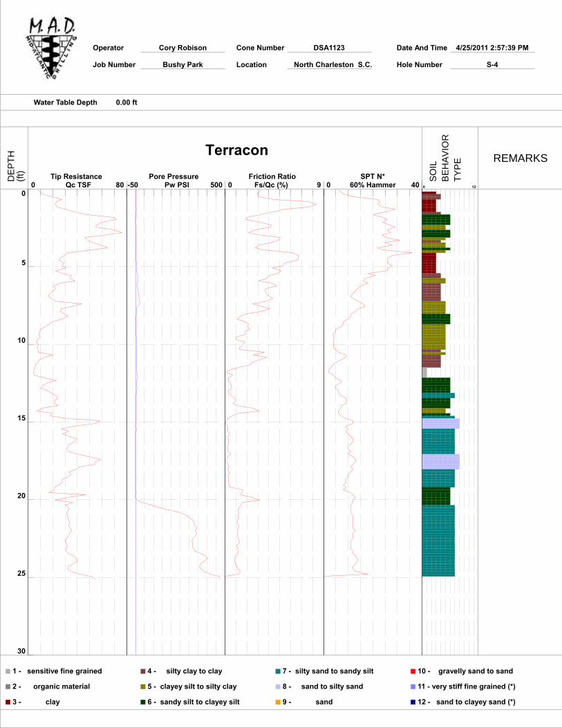
Operator Cory Robison Cone Number DSA1123 Date And Time 4/25/2011 2:57:39 PM
Job Number Bushy Park Location North Charleston S.C. Hole Number S-4
Water Table Depth 0.00 ft
0
5
10
15
20
25
30
0 80 Tip Resistance
Qc TSF -50 500 Pore Pressure
Pw PSI 0 9 Friction Ratio Fs/Qc (%) 0 40
SPT N*60% Hammer 0 12
1 - sensitive fine grained
2 - organic material
3 - clay
4 - silty clay to clay
5 - clayey silt to silty clay
6 - sandy silt to clayey silt
7 - silty sand to sandy silt
8 - sand to silty sand
9 - sand
10 - gravelly sand to sand
11 - very stiff fine grained (*)
12 - sand to clayey sand (*)
TerraconREMARKS
DE
PT
H(f
t)
SO
ILB
EH
AV
IOR
TY
PE
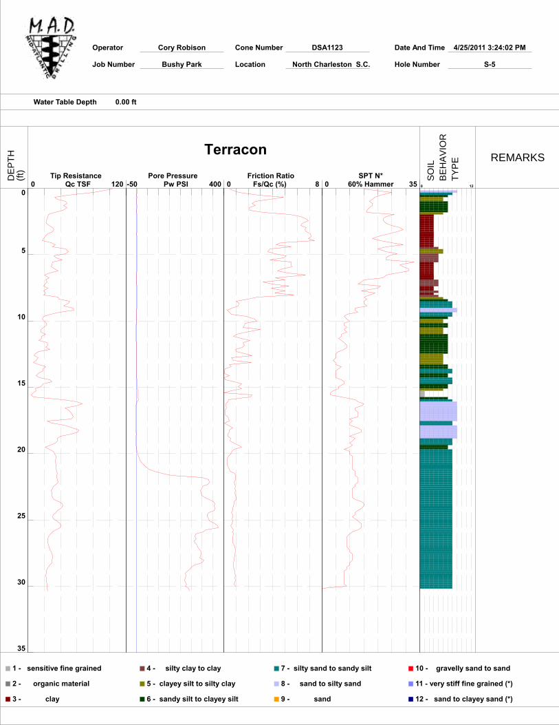
Operator Cory Robison Cone Number DSA1123 Date And Time 4/25/2011 3:24:02 PM
Job Number Bushy Park Location North Charleston S.C. Hole Number S-5
Water Table Depth 0.00 ft
0
5
10
15
20
25
30
35
0 120 Tip Resistance
Qc TSF -50 400 Pore Pressure
Pw PSI 0 8 Friction Ratio Fs/Qc (%) 0 35
SPT N*60% Hammer 0 12
1 - sensitive fine grained
2 - organic material
3 - clay
4 - silty clay to clay
5 - clayey silt to silty clay
6 - sandy silt to clayey silt
7 - silty sand to sandy silt
8 - sand to silty sand
9 - sand
10 - gravelly sand to sand
11 - very stiff fine grained (*)
12 - sand to clayey sand (*)
TerraconREMARKS
DE
PT
H(f
t)
SO
ILB
EH
AV
IOR
TY
PE

HAND AUGER BORING LOGS
Project Name: Bushy Park Industrial Complex New Development Subject Property
Date: 04/26/11
Project Number: EN115023 Engineer: BTS
Project Location: Goose Creek, SC Technician: JB
Test Number
Depth (inches)
Soil Stratigraphy USCS
ClassificationFrom To Description and Remarks
HAB by S-1
0 4 Topsoil
4 28 Brown Silty SAND SM
28 48 Light Brown and Red Sandy CLAY CL
No Groundwater Encountered
HAB by S-2
0 6 Topsoil
6 31 Brown Silty SAND SM
31 48 Light Brown and Red Clayey SAND SC
No Groundwater Encountered
HAB by S-3
0 8 Topsoil
8 16 Brown Silty SAND SM
16 48 Light Brown and Red Clayey SAND SC
No Groundwater Encountered
HAB by S-4
0 6 Topsoil
6 20 Brown Silty SAND SM
20 32 Light Brown Silty SAND SM
32 48 Light Brown and Red Sandy CLAY CL
No Groundwater Encountered
HAND AUGER BORING LOGS
Project Name: Bushy Park Industrial Complex New Development Subject Property
Date: 04/26/11
Project Number: EN115023 Engineer: BTS
Project Location: Goose Creek, SC Technician: JB
Test Number
Depth (inches)
Soil Stratigraphy USCS
ClassificationFrom To Description and Remarks
HAB by S-5
0 6 Topsoil
6 18 Brown Silty SAND SM
18 35 Light Brown Silty SAND SM
35 48 Light Brown and Red Clayey SAND SC
No Groundwater Encountered
Geotechnical Engineering Report Blue Bell Facility ■ North Charleston, South Carolina Project No. EN095355
Reliable ■ Responsive ■ Convenient ■ Innovative Exhibit A-1
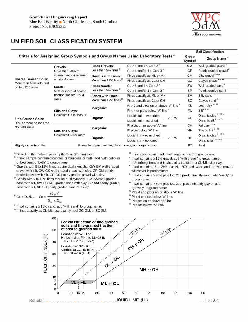
UNIFIED SOIL CLASSIFICATION SYSTEM
Criteria for Assigning Group Symbols and Group Names Using Laboratory Tests A Soil Classification
Group Symbol
Group Name B
Coarse Grained Soils: More than 50% retained on No. 200 sieve
Gravels: More than 50% of coarse fraction retained on No. 4 sieve
Clean Gravels: Less than 5% fines C
Cu 4 and 1 Cc 3 E GW Well-graded gravel F
Cu 4 and/or 1 Cc 3 E GP Poorly graded gravel F
Gravels with Fines: More than 12% fines C
Fines classify as ML or MH GM Silty gravel F,G,H
Fines classify as CL or CH GC Clayey gravel F,G,H
Sands: 50% or more of coarse fraction passes No. 4 sieve
Clean Sands: Less than 5% fines D
Cu 6 and 1 Cc 3 E SW Well-graded sand I
Cu 6 and/or 1 Cc 3 E SP Poorly graded sand I
Sands with Fines: More than 12% fines D
Fines classify as ML or MH SM Silty sand G,H,I
Fines classify as CL or CH SC Clayey sand G,H,I
Fine-Grained Soils: 50% or more passes the No. 200 sieve
Silts and Clays: Liquid limit less than 50
Inorganic: PI 7 and plots on or above “A” line J CL Lean clay K,L,M
PI 4 or plots below “A” line J ML Silt K,L,M
Organic: Liquid limit - oven dried
0.75 OL Organic clay K,L,M,N
Liquid limit - not dried Organic silt K,L,M,O
Silts and Clays: Liquid limit 50 or more
Inorganic: PI plots on or above “A” line CH Fat clay K,L,M
PI plots below “A” line MH Elastic Silt K,L,M
Organic: Liquid limit - oven dried
0.75 OH Organic clay K,L,M,P
Liquid limit - not dried Organic silt K,L,M,Q
Highly organic soils: Primarily organic matter, dark in color, and organic odor PT Peat
A Based on the material passing the 3-in. (75-mm) sieve B If field sample contained cobbles or boulders, or both, add “with cobbles
or boulders, or both” to group name. C Gravels with 5 to 12% fines require dual symbols: GW-GM well-graded
gravel with silt, GW-GC well-graded gravel with clay, GP-GM poorly graded gravel with silt, GP-GC poorly graded gravel with clay.
D Sands with 5 to 12% fines require dual symbols: SW-SM well-graded sand with silt, SW-SC well-graded sand with clay, SP-SM poorly graded sand with silt, SP-SC poorly graded sand with clay
E Cu = D60/D10 Cc =
6010
2
30
DxD
)(D
F If soil contains 15% sand, add “with sand” to group name. G If fines classify as CL-ML, use dual symbol GC-GM, or SC-SM.
H If fines are organic, add “with organic fines” to group name. I If soil contains 15% gravel, add “with gravel” to group name. J If Atterberg limits plot in shaded area, soil is a CL-ML, silty clay. K If soil contains 15 to 29% plus No. 200, add “with sand” or “with gravel,”
whichever is predominant. L If soil contains 30% plus No. 200 predominantly sand, add “sandy” to
group name. M If soil contains 30% plus No. 200, predominantly gravel, add
“gravelly” to group name. N PI 4 and plots on or above “A” line. O PI 4 or plots below “A” line. P PI plots on or above “A” line. Q PI plots below “A” line.