1.0 DESCRIPTION OF THE PROPOSED PROJECT
22
New Jersey Turnpike Interchange 6 – 9 Widening Executive Order No. 215 Environmental Impact Statement 1-1 1.0 DESCRIPTION OF THE PROPOSED PROJECT 1.1 Introduction This Environmental Impact Statement (EIS) describes the environmental implications and proposed mitigation measures associated with the proposed widening of and improvements to the New Jersey Turnpike from the vicinity of the mainline interconnection with the Pearl Harbor Memorial Turnpike Extension at Milepost 51.0, commonly referred to as Interchange 6, to the southern terminus of the existing ten-lane dual-dual roadway immediately south of Interchange 8A. This action is referred to as the “Proposed Project” throughout this document. Because the Turnpike Authority has determined that 6 lanes are necessary south of Interchange 8A and due to a desire to support operational safety and equalize an imbalance of traffic flow between areas north of Interchange 9 with areas to the south of Interchange 9, the Proposed Project also includes the addition of a third lane to the outer roadways of the 10-lane dual-dual roadway segment between Interchanges 8A and 9. Therefore, the Proposed Project and its associated study area extends from a point located approximately three miles south of Interchange 6 at Milepost 48.2 (Assiscunk Creek) at the south end to the N.J. Route 18 crossing of the Turnpike south of Interchange 9 at approximately Milepost 83.0 at the north end. The total length of the Proposed Project is almost 35 miles, and it spans eleven communities and passes through portions of three counties (Burlington, Mercer and Middlesex) in central New Jersey. This EIS has been prepared in accordance with New Jersey State Executive Order No. 215 (1989), which requires state departments, agencies and authorities to submit an environmental assessment or environmental impact statement to the New Jersey Department of Environmental Protection (NJDEP) to document the environmental effects of major construction projects. Projects with construction costs in excess of $5 million and land disturbance in excess of five acres, which includes the Proposed Project, are categorized as Level 2 projects and are subject to the preparation of an environmental impact statement. In this regard, the EIS to be prepared subsequent to NJDEP’s review and comment, provides the basis upon which NJDEP will ultimately make its recommendations pertaining to the Proposed Project. This section of the EIS describes the Proposed Project, including its design and operation, and its construction methods and schedule. The purpose of and need for the Proposed Project are described in Section 2.0. Section 3.0 describes the baseline conditions of the Project Corridor while Section 4.0 discusses the potential impacts of the Proposed Project and recommended mitigation measures. Section 5.0 contains an evaluation of the alternatives to the Proposed Project and Section 6.0 describes the Authority’s agency coordination and public outreach efforts. Sections 7.0 and 8.0 contain references and a list of preparers of the EIS, respectively. 1.2 Project Sponsor The New Jersey Turnpike Authority (Authority) is the sponsor of the Proposed Project. The Authority was established by the Turnpike Authority Act (N.J.S.A 27:23-1 et seq.), which was enacted by the State Legislature in October 1948 with the purpose “to construct, maintain, repair and operate a modern express highway in New Jersey.” 1.3 Project Setting, Turnpike History and Regional Transportation Context The Proposed Project and its associated study area extends from a point approximately three miles south of Turnpike Interchange 6 (just north of Assiscunk Creek) in Mansfield Township, Burlington County, to a point just south of Interchange 9 in East Brunswick Township, Middlesex County, for a
Transcript of 1.0 DESCRIPTION OF THE PROPOSED PROJECT

New Jersey Turnpike Interchange 6 – 9 Widening Executive Order No. 215 Environmental Impact Statement
1-1
1.0 DESCRIPTION OF THE PROPOSED PROJECT
1.1 Introduction This Environmental Impact Statement (EIS) describes the environmental implications and proposed mitigation measures associated with the proposed widening of and improvements to the New Jersey Turnpike from the vicinity of the mainline interconnection with the Pearl Harbor Memorial Turnpike Extension at Milepost 51.0, commonly referred to as Interchange 6, to the southern terminus of the existing ten-lane dual-dual roadway immediately south of Interchange 8A. This action is referred to as the “Proposed Project” throughout this document. Because the Turnpike Authority has determined that 6 lanes are necessary south of Interchange 8A and due to a desire to support operational safety and equalize an imbalance of traffic flow between areas north of Interchange 9 with areas to the south of Interchange 9, the Proposed Project also includes the addition of a third lane to the outer roadways of the 10-lane dual-dual roadway segment between Interchanges 8A and 9. Therefore, the Proposed Project and its associated study area extends from a point located approximately three miles south of Interchange 6 at Milepost 48.2 (Assiscunk Creek) at the south end to the N.J. Route 18 crossing of the Turnpike south of Interchange 9 at approximately Milepost 83.0 at the north end. The total length of the Proposed Project is almost 35 miles, and it spans eleven communities and passes through portions of three counties (Burlington, Mercer and Middlesex) in central New Jersey. This EIS has been prepared in accordance with New Jersey State Executive Order No. 215 (1989), which requires state departments, agencies and authorities to submit an environmental assessment or environmental impact statement to the New Jersey Department of Environmental Protection (NJDEP) to document the environmental effects of major construction projects. Projects with construction costs in excess of $5 million and land disturbance in excess of five acres, which includes the Proposed Project, are categorized as Level 2 projects and are subject to the preparation of an environmental impact statement. In this regard, the EIS to be prepared subsequent to NJDEP’s review and comment, provides the basis upon which NJDEP will ultimately make its recommendations pertaining to the Proposed Project. This section of the EIS describes the Proposed Project, including its design and operation, and its construction methods and schedule. The purpose of and need for the Proposed Project are described in Section 2.0. Section 3.0 describes the baseline conditions of the Project Corridor while Section 4.0 discusses the potential impacts of the Proposed Project and recommended mitigation measures. Section 5.0 contains an evaluation of the alternatives to the Proposed Project and Section 6.0 describes the Authority’s agency coordination and public outreach efforts. Sections 7.0 and 8.0 contain references and a list of preparers of the EIS, respectively.
1.2 Project Sponsor The New Jersey Turnpike Authority (Authority) is the sponsor of the Proposed Project. The Authority was established by the Turnpike Authority Act (N.J.S.A 27:23-1 et seq.), which was enacted by the State Legislature in October 1948 with the purpose “to construct, maintain, repair and operate a modern express highway in New Jersey.”
1.3 Project Setting, Turnpike History and Regional Transportation Context
The Proposed Project and its associated study area extends from a point approximately three miles south of Turnpike Interchange 6 (just north of Assiscunk Creek) in Mansfield Township, Burlington County, to a point just south of Interchange 9 in East Brunswick Township, Middlesex County, for a

New Jersey Turnpike Interchange 6 – 9 Widening Executive Order No. 215 Environmental Impact Statement
1-2
total length of almost 35 miles. It traverses the following central New Jersey communities in south-to-north order:
� The townships of Mansfield, Bordentown and Chesterfield, in Burlington County; � The townships of Hamilton, Washington and East Windsor, in Mercer County; and � The townships of Cranbury, Monroe, South Brunswick and East Brunswick, and the Borough
of Milltown, in Middlesex County.
The project area in relation to the entire central New Jersey region is depicted in Figure 1-1. The project area has undergone and is continuing to experience a rapid transformation from a rural environment to a more suburban one, as urbanization and population growth have spread into central New Jersey, which is situated to the north of Philadelphia and its older suburbs and to the south of New York City and its older suburbs. Job growth has followed the population growth. The nature of this growth and development has led to widely dispersed trip origins and destinations, which have contributed to increasing congestion along the Proposed Project Corridor of the Turnpike. The New Jersey Turnpike is the principal north-south travel corridor in the State, and is a critical link in the transportation system of the northeastern United States, serving as a connection between Washington, D.C. and other points south, to New York City, New England and other points to the north. The Turnpike is considered to be the north-south spine within the growing area of central New Jersey, and has connections with all of central New Jersey’s key east-west highways, including the Pearl Harbor Memorial Extension to the Pennsylvania Turnpike (Interchange 6); Route I-195 (Interchange 7A); New Jersey Route 33 (Interchange 8); and N.J. Route 18 (Interchange 9). While there are other north-south highways paralleling the Turnpike (e.g., U.S. Routes 1, 130, and 206, as well as Route I-295), these highways do not serve the same function as the Turnpike and/or do not provide the same level of system continuity as the Turnpike. Most segments of the New Jersey Turnpike, including the entire Proposed Project area, opened to traffic in late 1951, although the entire roadway from Deepwater to Ridgefield Park was completed in January 1952.1 Originally, there were four travel lanes (two in each direction) constructed between Interchanges 1 and 11, increasing to six lanes (three in each direction) between Interchanges 11 and 16. North of Interchange 16, the facility decreased to four lanes again to U.S. Route 46 in Ridgefield Park, the northern terminus of the Turnpike at that time. Significant traffic growth associated with population and employment growth that occurred in the years since the Turnpike’s opening has resulted in the widening of all sections of the Turnpike, except between Interchanges 1 and 4, to accommodate increased travel demand. In 1955, the first mainline widening of the Turnpike between Interchange 4 in Mount Laurel and Interchange 10 in Edison, including the entire Proposed Project area, was undertaken, resulting in the roadway being widened to six lanes (three in each direction). In addition, other areas of the Turnpike were widened and other roadways were constructed as part of the overall Turnpike system during that same year and into the 1970s. One addition to the Turnpike system constructed in 1956 that has particular relevance to the Proposed Project was the addition of the extension to the Pennsylvania Turnpike at Interchange 6, which is currently known as the Pearl Harbor Memorial Turnpike Extension. The dual-dual roadway configuration, where travel lanes in both directions are divided by a median to separate commercial (i.e., truck) traffic from automobile traffic, was implemented in the mid-1960s to enhance safety on the Turnpike and allow for balancing of traffic during incidents and/or construction and maintenance activities. The original “dualization” of the Turnpike took place between Interchange
1 http://www.nycroads.com/roads/nj-turnpike/

BURLINGTONCOUNTY
SOMERSET COUNTYHUNTERDON
COUNTY
195
130
1
9
MERCERCOUNTY
MIDDLESEXCOUNTY
MONMOUTHCOUNTY
OCEANCOUNTY
206
20631
95
295
Pennsylvania
Interchange6
Interchange7
Interchange7A
Interchange8
Interchange8A
Interchange9
0 5 102.5Miles
REGIONAL LOCATION
FIGURE 1-1
NEW JERSEY TURNPIKE AUTHORITY
NEW JERSEY TURNPIKE
New Jersey Turnpike Interchange 6 to 9 WideningBurlington, Mercer and Middlesex Counties
Executive Order No. 215 Environmental Impact Statement
New Je
rsey T
urnpike
Legend
County Boundary
Proposed Project Corridor
Pearl Harbor Me morial Turnpike E xtens ion

New Jersey Turnpike Interchange 6 – 9 Widening Executive Order No. 215 Environmental Impact Statement
1-4
10 and Interchange 14 in Newark. By the early 1970s, the dual-dual concept had been extended south to Interchange 9, thereby providing a twelve-lane facility (three lanes on separate inner and outer roadways in each direction) between Interchange 9 in East Brunswick and Interchange 14. The dual-dual concept was extended further south when separate outer roadways accommodating both truck and automobile traffic were constructed and opened to traffic in 1990 between Interchange 8A in Monroe and Interchange 9 in East Brunswick. Although that project was designed and constructed to eventually accommodate three lanes in each outer roadway, for the purpose of making the cross-section of each roadway consistent with those located to the north, only two lanes were actually constructed for each roadway at that time. Nevertheless, the EIS submitted to and approved by NJDEP under Executive Order No. 53 (1973), the predecessor to Executive Order No. 215, was based on an assessment of the impacts associated with the three lanes originally proposed to be constructed in each outer roadway. This approach was utilized since all cut and embankment placement, bridges, drainageways, noise barriers, lighting and retaining walls were constructed to accommodate the addition of the third lane in each direction in the future. A further widening of the dual-dual Turnpike facility was also completed between Interchanges 11 and 14 during the 1990s. Along this stretch of the Turnpike, an additional lane was constructed along each of the three-lane outer roadways, making the Turnpike a total of 14 lanes wide (seven lanes in each direction, with three lanes on each inner roadway and four lanes on each outer roadway). With the completion of that widening, the dual-dual portion of the Turnpike presently consists of the following components:
� three inner (automobile-only) lanes in each direction from Interchange 8A to Interchange 14; � two outer (automobile and commercial) lanes in each direction from Interchange 8A to
Interchange 9; � three outer (automobile and commercial) lanes in each direction from Interchange 9 to
Interchange 11; and � four outer (automobile and commercial) lanes in each direction from Interchange 11 to
Interchange 14, of which, one lane in each direction serves as a high occupancy vehicle (HOV) lane during peak commuting hours.
The dual-dual facility transitions to a six-lane roadway, three lanes in each direction, immediately to the south of Interchange 8A. Interchanges 8A and 7A were originally constructed in the mid-1970s to accommodate new growth occurring along the Turnpike in that corridor. This six-lane configuration, which encompasses the entire Proposed Project area, continues southward to Interchange 4 in Mount Laurel, where it decreases to a four-lane facility (two lanes in each direction) to the southern Turnpike terminus in Deepwater, located immediately north of the Delaware Memorial Bridge over the Delaware River. In addition to the several widening and other improvement projects that have been undertaken along the Turnpike during the past 50+ years, the Authority has implemented new toll programs (e.g., E-ZPass lanes, value pricing) to provide increased accessibility, capacity/throughput, and convenience to current and future motorists on the Turnpike. The Authority embarked on a long-range planning process for the New Jersey Turnpike in November 2001. The purpose of the planning process was to update previous traffic and toll revenue forecasts, and to provide a system-wide capacity analysis of the Turnpike reflecting the updated traffic forecasts. The Authority is using the Third Draft of the Long-Range Plan2 to aid in its planning for capital improvements to address traffic capacity needs. According to this document, traffic levels of service are projected along the Turnpike for all mainline segments, ramps, and toll plazas for various future
2 Wilbur Smith Associates, New Jersey Turnpike Long-Range Plan, April 2004, Third Draft.

New Jersey Turnpike Interchange 6 – 9 Widening Executive Order No. 215 Environmental Impact Statement
1-5
years. The Long-Range Plan identified the section of the Turnpike mainline between Interchanges 7A and 9 as one of the most congested sections, both northbound and southbound during AM and PM peak hours, based on both 2006 and future projected traffic volumes. One of the significant factors for the projected increase in traffic volumes within the limits of the Proposed Project is the anticipated construction of the Route I-95/I-276 Interchange in Pennsylvania, which will allow drivers to directly connect from I-95 in Pennsylvania to the New Jersey Turnpike at Interchange 6, and vice versa, via the Pearl Harbor Memorial Turnpike Extension. The Proposed Project is primarily intended to address the existing and projected future congestion within the Interchange 6 to 8A segments. However, due to continued traffic growth on the Turnpike, and the continued growth and development in the central New Jersey region as a whole, the Proposed Project also includes the addition of the third lane to the outer roadways between Interchanges 8A and 9.
1.4 Project Design and Operation
1.4.1 Design Criteria The Authority’s Design Manual (1987, with amendments) and Design Standards (1996) provide the primary design criteria for the Proposed Project. Some modifications to these criteria have been utilized in the design of the Proposed Project, as follows:
� The Authority intends to modify its acceleration lane standards to conform to current American Association of State Highway and Transportation Officials (AASHTO) requirements for high-speed facilities. This results in an approximately 350-foot longer acceleration lane than exists in the current standard.
� The Authority intends to increase the ramp shoulder width from 10 feet to 12 feet. In addition, the following criteria were utilized for specific design elements of the Proposed Project:
� 2004 AASHTO Policy on Geometric Design of Highways and Streets, Chapter 10, Grade Separations and Interchanges.
� 2003 Federal Highway Administration (FHWA) Manual on Uniform Traffic Control Devices for Streets and Highways, Chapter 3, Pavement Markings.
� New Jersey Department of Transportation (NJDOT) Design Manual – Roadways. � Criteria based on studies performed by the Authority on existing weaving and merge/diverge
operations.
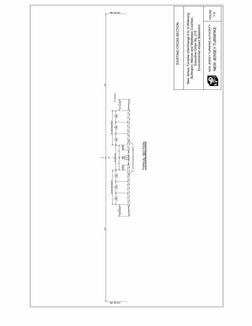
1.4.2 Description of the Proposed Improvements The New Jersey Turnpike is currently a six-lane roadway (three lanes in each direction) from Interchange 6 in Mansfield Township to just south of Interchange 8A in Monroe Township (Figure 1-2). The roadway in this area also includes 12-foot wide right shoulders and approximately 11½-foot-wide left shoulders in each direction, with the northbound and southbound traffic lanes separated by a 42-inch high reinforced concrete median barrier. The proposed improvements to the Turnpike include widening of the mainline from six lanes to twelve lanes as a dual-dual facility from a point approximately two miles south of Interchange 6 to the existing ten-lane dual-dual roadway south of Interchange 8A, along with the addition of the third lane to the outer roadways of the ten-lane dual- dual roadway between Interchanges 8A and 9 (Figure 1-3). Also included as part of the Proposed Project are improvements to interchanges and service areas, and construction of police/maintenance u-turn bridges, Best Management Practices (BMP) stormwater management facilities, and the southerly

New Jersey Turnpike Interchange 6 – 9 Widening Executive Order No. 215 Environmental Impact Statement
1-6
existing six-lane Turnpike south of Interchange 6 as necessary to accommodate the proposed widening. These improvements are described below.
� Proposed mainline widening – The existing six-lane facility is proposed to become a dual-dual
12-lane facility by adding two new roadways of three lanes each. The widening will generally occur by adding new outer lanes along each side of the existing Turnpike, thereby continuing the dual-dual roadway concept that exists along Turnpike segments to the north. The new outer lanes will serve automobile and commercial traffic, while the inner lanes will serve automobile traffic exclusively. The proposed dual-dual roadway will begin at a point about two miles south of Interchange 6 and will connect with the outer roadways that currently begin south of Interchange 8A. Each three-lane roadway will also include a 12-foot wide right shoulder and a 5-foot wide left shoulder in accordance with the Authority’s design requirements. The proposed widening scheme is also shown in Figure 1-3.
� Interchange 6 – The Pearl Harbor Memorial Turnpike Extension (PHMTE) is a six-lane east-
west roadway that connects the New Jersey Turnpike to the Pennsylvania Turnpike at the Delaware River to the west. The PHMTE terminates at the Turnpike mainline at Milepost 51.00 in Mansfield Township, Burlington County, with two-lane, high-speed ramp connections to and from the north, and one-lane, lower-speed ramp connections to and from the south. The ramp connections from the south to the PHMTE and from the PHMTE to the north pass over the Turnpike mainline. The widening of the Turnpike through this area will result in the dual-dual roadway section extending approximately two miles south of the interchange. The proposed design of this interchange provides for two-lane ramp connections to and from the north and the south, for both the inner and outer roadways. These ramp connections will be elevated and cross over the various roadways. The proposed location and design of the Interchange 6 improvements are depicted in Figure 1-4.
� Interchange 7 – Interchange 7 is located at Milepost 53.7 in Bordentown Township,
Burlington County, approximately 4,000 feet north of the Turnpike crossing of U.S. Route 206. This interchange provides a connection between the Turnpike and Route 206, and currently includes a 12-lane toll plaza located between the trumpet interchanges along the Turnpike and Route 206. The toll plaza and Turnpike trumpet interchange ramps were relocated in 1990. The horizontal and vertical geometry of the existing interchange ramps were configured at that time to accommodate the future dualization of the Turnpike with minimal disruption to existing ramps and roadways and to avoid impacts that the future dualization would have on the PSE&G electric transmission facilities present at this interchange. As part of the Proposed Project, the Turnpike mainline would be widened with new three-lane outer roadways through the Interchange 7 area. Although no change in the number of toll lanes at the Interchange 7 toll plaza is proposed, new ramps connecting the proposed outer roadways to the toll plaza would be required, along with minor modifications to the existing ramps. There would also be twelve new mainline bridges, four in each direction within the Interchange area, as well as bridges over Route 206, Blacks Creek, Bordentown-Georgetown Road, and a new maintenance u-turn overpass near Milepost 53.3; the latter four bridges would be located south of Interchange 7. The proposed location and design of the Interchange 7 improvements are shown in Figure 1-5.
� Service Areas 6S and 6N – The existing 6S (Richard Stockton, adjacent to the southbound
roadway) and 6N (Woodrow Wilson, adjacent to the northbound roadway) Service Areas are located at Milepost 58.7, approximately 2,500 feet south of the Merrick Road bridge and approximately 3,000 feet north of the Yardville-Allentown Road bridge in Hamilton Township, Mercer County. The Turnpike service areas provide separate parking and fueling facilities for automobiles, trucks and buses. At the service area entrances, vehicles are separated by vehicle
TYP
ICA
L S
EC
TIO
N
12’
SH
OU
LDE
R
150’
12’
LAN
E
36’ N
SI R
OA
DW
AY
12’
LAN
E12
’LA
NE
5’SH
LDR
5’SH
LDR
13’
13’
26’ M
ED
IAN
36’ S
NI R
OA
DW
AY
12’
LAN
E12
’LA
NE
12’
LAN
E
C L
26’ M
ED
IAN
12’
SH
OU
LDE
R
150’
EX
ISTI
NG
TUR
NP
IKE
PAV
EM
EN
T
FIG
UR
EN
EWJE
RS
EY
TUR
NP
IKE
AU
THO
RIT
Y
NEW
JER
SEY
TUR
NPI
KE
Hedding-MansfieldRoad
U.S.Route206
EX
ISTI
NG
CR
OS
S S
EC
TIO
N
1-2
New
Jers
eyTu
rnpi
keIn
terc
hang
e6
toW
iden
ing
Burli
ngto
n,M
erce
rand
Mid
dles
exC
ount
ies
Exec
utiv
eO
rder
No.
215
Envi
ronm
enta
lIm
pact
Stat
emen
t
9

TYP
ICA
L S
EC
TIO
N
6’B
ER
M12
’S
HO
ULD
ER
12’
LAN
E12
’LA
NE
5’SH
LDR
36’ N
SO
RO
AD
WAY
26’ M
ED
IAN
12’
SH
OU
LDE
R
12’
LAN
E
123’
150’
12’
LAN
E
36’ N
SI R
OA
DW
AY
12’
LAN
E12
’LA
NE
5’SH
LDR
5’SH
LDR
13’
13’
26’ M
ED
IAN
36’ S
NI R
OA
DW
AY
12’
LAN
E12
’LA
NE
12’
LAN
E
C L
26’ M
ED
IAN
5’SH
LDR
12’
LAN
E12
’LA
NE
12’
LAN
E12
’S
HO
ULD
ER
6’B
ER
M12
’S
HO
ULD
ER
123’
150’
36’ S
NO
RO
AD
WAY
PR
OP
OS
ED
TU
RN
PIK
E P
AVE
ME
NT
PR
OP
OS
ED
TU
RN
PIK
E P
AVE
ME
NT
EX
ISTI
NG
TUR
NP
IKE
PAV
EM
EN
T
FIG
UR
EN
EWJE
RS
EY
TUR
NP
IKE
AU
THO
RIT
Y
NEW
JER
SEY
TUR
NPI
KE
Hedding-MansfieldRoad
U.S.R
oute
206
PR
OP
OS
ED
TY
PIC
AL
CR
OS
S -S
EC
TIO
N
1-3
New
Jers
eyTu
rnpi
keIn
terc
hang
e6
toW
iden
ing
Burli
ngto
n,M
erce
rand
Mid
dles
exC
ount
ies
Exec
utiv
eO
rder
No.
215
Envi
ronm
enta
lIm
pact
Stat
emen
t
9

NEW
JER
SE
YTU
RN
PIK
EA
UTH
OR
ITY
NEW
JER
SEY
TUR
NPI
KE
Hedding-MansfieldRoad
U.S.Route206
FIG
UR
E1-
4
Pro
pose
d Im
prov
emen
ts a
t Int
erch
ange
6
...\In
terc
hang
e 6
Con
cept
s-- A
lt 2.
dgn
7/6
/200
6 2:
16:4
2 P
M
$
...\IN
T6S
6N-A
LT-3
A.d
gn 7
/11/
2006
9:5
8:58
AM
New
Jers
eyTu
rnpi
keIn
terc
hang
e6
toW
iden
ing
Burli
ngto
n,M
erce
rand
Mid
dles
exC
ount
ies
Exec
utiv
eO
rder
No.
215
Envi
ronm
enta
lIm
pact
Stat
emen
t
9

...\IN
T6S
6N-A
LT-3
A.d
gn 7
/11/
2006
9:5
8:58
AM
NEW
JER
SE
YTU
RN
PIK
EA
UTH
OR
ITY
NEW
JER
SEY
TUR
NPI
KE
Hedding-MansfieldRoad
U.S.Route206
FIG
UR
E1-
5
Pro
pose
d Im
prov
emen
ts a
t Int
erch
ange
7...
\Int7
_Fin
al_P
rese
ntat
ion_
1228
05.d
gn 7
/6/2
006
2:22
:52
PM
$
New
Jers
eyTu
rnpi
keIn
terc
hang
e6
toW
iden
ing
Burli
ngto
n,M
erce
rand
Mid
dles
exC
ount
ies
Exec
utiv
eO
rder
No.
215
Envi
ronm
enta
lIm
pact
Stat
emen
t
9

New Jersey Turnpike Interchange 6 – 9 Widening Executive Order No. 215 Environmental Impact Statement
1-15
type and diverted to parking facilities through the use of signage. Both Service Areas 6S and 6N have access to the local road network through existing access roads for use by service area employees and emergency vehicles. The Turnpike widening in this area will require access ramps to the service areas to and from the inner and outer roadways. The access ramps must provide sufficient length of a two-lane ramp section to permit a weaving maneuver between the different types of vehicles exiting or entering the inner and outer roadways. In addition to the new access ramps, the existing local road bridges referenced above would need to be realigned horizontally and vertically to cross over the dualized Turnpike section and service area ramp connections to the inner and outer roadways. No additional parking spaces are anticipated to be provided at either service area. The proposed location and design of the Service Areas 6S and 6N improvements are shown in Figure 1-6.
� Interchange 7A – Interchange 7A is located near Milepost 60.5 in Hamilton and Washington
Townships, Mercer County, and connects Route I-195 with the New Jersey Turnpike. The interchange consists of trumpet interchange connections to each roadway, with the existing toll plaza situated in the southwest quadrant of the intersecting roadways. The Route I-195 eastbound and westbound roadways pass over the Turnpike on separate bridge structures. The existing Turnpike toll plaza has ten toll lanes, some of which serve as reversible lanes. In order to accommodate the projected increase in traffic volumes utilizing the Turnpike, the toll plaza must be widened from ten lanes to 13 lanes, and the Route I-195 trumpet interchange ramps widened to two lanes and improved geometrically. The proposed location and design of the Interchange 7A improvements are shown in Figure 1-7.
� Interchange 8 – The Interchange 8 toll plaza is located on the southbound side of the Turnpike
at Milepost 67.6 in East Windsor Township, Mercer County. The existing interchange is a standard trumpet design providing access to and from the five-lane toll plaza, the Turnpike mainline, and N.J. Route 33. The existing toll plaza is situated in relatively close proximity to the Turnpike mainline, N.J. Route 33 and the Turnpike’s Central Shops maintenance yard. The existing configuration of the toll plaza does not meet current Turnpike toll plaza configuration requirements for providing a 500-foot minimum distance between the toll plaza and the ramp terminals. The proposed widening in this location will require a new 12-lane toll plaza, modified access to the Central Shops maintenance area, and modified Turnpike ramps. The existing Turnpike interchange with N.J. Route 33 is also in close proximity to the center of Hightstown, thereby causing traffic destined to and from the Turnpike with origins west of Hightstown to travel through the downtown Hightstown area. In the 1990s, the NJDOT completed construction of N.J. Route 133, to circumvent the downtown area. The Authority proposes to relocate the Interchange 8 toll plaza to the east side of the Turnpike and connect the interchange ramps directly with N.J. Route 133 by grade separating the existing N.J. Routes 33/133 signalized intersection. The proposed location and design of the Interchange 8 improvements are shown in Figure 1-8.
� Service Area 7S – Existing Service Area 7S is situated along the southbound side of the
Turnpike at Milepost 71.5 in Cranbury Township, Middlesex County. It is approximately 1.4 miles south of the southbound merge of the ten-lane Turnpike section, and approximately 2.0 miles south of Interchange 8A. The New Jersey State Police Troop D Headquarters is situated adjacent to the service area to the south. The service area has direct access to and from the southbound roadway via at-grade ramps. Similar to the description for Service Areas 6S and 6N above, the proposed widening in this area will require access ramps to the service area to and from the inner and outer roadways. These ramps must provide sufficient length for a two-lane ramp section to permit a weaving maneuver between the different types of vehicles exiting or entering the inner and outer roadways. The other improvements associated with Service Area 7S include a new police u-turn bridge, and realignment of both the Cranbury-Half Acre

New Jersey Turnpike Interchange 6 – 9 Widening Executive Order No. 215 Environmental Impact Statement
1-16
Road and Prospect Plains Road bridges. The proposed location and design of the Service Area 7S improvements are shown in Figure 1-9.
� Stormwater Management BMP – To comply with NJDEP stormwater management
regulations for control of stormwater runoff quantity and quality from impervious roadway areas, the Proposed Project will include construction of detention basins, water quality swales and water quality chambers as part of the roadway drainage system. These facilities are proposed in order to detain the peak runoff flow from the roadway and remove a large percentage of the Total Suspended Solids from the stormwater before discharge to waterways.
� Police/Maintenance U-Turns – The dual-dual Turnpike roadway configuration utilizes grade separated u-turns to accommodate State Police patrol of the Turnpike, emergency response to incidents along the Turnpike and the conduct of roadway maintenance by the Authority’s Maintenance Department. The u-turn bridges are situated within one mile of, and on each side of an interchange or service area, and are no more than five miles apart between interchanges. The bridges span over the inner and outer roadways of the dualized Turnpike section and connect at right angle intersections with the outer roadways. The infield areas of the u-turn facilities may be utilized to locate stormwater management basins.
As noted above, the proposed Turnpike north of Interchange 6 would be a 12-lane dual-dual roadway with two new three-lane roadways in each direction. The existing roadway section south of Interchange 6 is a six-lane Turnpike section with one three-lane roadway in each direction. The two southbound roadways of the new dual-dual facility will need to be merged from a combined six travel lanes to three travel lanes south of the interconnection with the PHMTE at Interchange 6. The existing three-lane northbound roadway will diverge from three travel lanes to the six travel lanes of the new widened Turnpike south of the PHMTE at Interchange 6. The proposed location and design of the southbound merge is depicted in Figure 1-10, while the proposed location and design of the northbound diverge is depicted in Figure 1-11. As described in Section 1.3, the existing ten-lane dual-dual roadway between Interchange 8A in Monroe Township and Interchange 9 in East Brunswick Township was constructed and opened to traffic in 1990. Although the project was designed and the roadway embankment was constructed to accommodate three lanes in each outer roadway, only two lanes were actually paved for each roadway at that time. However, all earthwork, bridges, drainageways, noise barriers, lighting and retaining walls were constructed to accommodate a three-lane outer roadway in each direction in the future. As part of the Proposed Project, the third outer lane in each direction will be paved along the segment between Interchanges 8A and 9, thereby making the cross-sections of both outer roadways uniform between Interchanges 6 and 9, as well as with the segments to the north. 1.4.3 Construction Methods and Schedule Construction of the Proposed Project is anticipated to occur over a five-year period from 2008 to 2013. General construction methods proposed to be employed during the construction period are presented below.
1.4.3.1 General Construction Methods – Earthwork The earthwork required prior to paving will generally proceed in the following sequence:
� Clearing and grubbing; � Topsoil removal (where necessary); � Excavation of unsuitable material (where necessary); and � Earth excavation and embankment construction.

NEW
JER
SE
YTU
RN
PIK
EA
UTH
OR
ITY
NEW
JER
SEY
TUR
NPI
KE
Hedding-MansfieldRoad
U.S.Route206
FIG
UR
E1-
6
Pro
pose
d Im
prov
emen
ts a
t Ser
vice
Are
as 6
S a
nd 6
N
...\IN
T6S
6N-A
LT-3
A.d
gn 7
/6/2
006
3:15
:06
PM
$
...\IN
T6S
6N-A
LT-3
A.d
gn 7
/11/
2006
9:5
8:58
AM
New
Jers
eyTu
rnpi
keIn
terc
hang
e6
toW
iden
ing
Burli
ngto
n,M
erce
rand
Mid
dles
exC
ount
ies
Exec
utiv
eO
rder
No.
215
Envi
ronm
enta
lIm
pact
Stat
emen
t
9

NEW
JER
SE
YTU
RN
PIK
EA
UTH
OR
ITY
NEW
JER
SEY
TUR
NPI
KE
Hedding-MansfieldRoad
U.S.R
oute
206
FIG
UR
E1-
7
Pro
pose
d Im
prov
emen
ts a
t Int
erch
ange
7A
...\7
A C
once
pt 5
Tw
o La
ne H
igh
Spe
ed S
ervi
ce R
oad.
dgn
7/6
/200
6 2:
41:5
0 P
M
$
...\IN
T6S
6N-A
LT-3
A.d
gn 7
/11/
2006
9:5
8:58
AM
New
Jers
eyTu
rnpi
keIn
terc
hang
e6
toW
iden
ing
Burli
ngto
n,M
erce
rand
Mid
dles
exC
ount
ies
Exec
utiv
eO
rder
No.
215
Envi
ronm
enta
lIm
pact
Stat
emen
t
9

NEW
JER
SE
YTU
RN
PIK
EA
UTH
OR
ITY
NEW
JER
SEY
TUR
NPI
KE
Hedding-MansfieldRoad
U.S.Route206
FIG
UR
E1-
8
Pro
pose
d Im
prov
emen
ts a
t Int
erch
ange
8
$
...\IN
T6S
6N-A
LT-3
A.d
gn 7
/11/
2006
9:5
8:58
AM
New
Jers
eyTu
rnpi
keIn
terc
hang
e6
toW
iden
ing
Burli
ngto
n,M
erce
rand
Mid
dles
exC
ount
ies
Exec
utiv
eO
rder
No.
215
Envi
ronm
enta
lIm
pact
Stat
emen
t
9

NEW
JER
SE
YTU
RN
PIK
EA
UTH
OR
ITY
NEW
JER
SEY
TUR
NPI
KE
Hedding-MansfieldRoad
U.S.Route206
FIG
UR
E1-
9
Pro
pose
d Im
prov
emen
ts a
t Ser
vice
Are
a 7S
$
$
...\IN
T6S
6N-A
LT-3
A.d
gn 7
/11/
2006
9:5
8:58
AM
New
Jers
eyTu
rnpi
keIn
terc
hang
e6
toW
iden
ing
Burli
ngto
n,M
erce
rand
Mid
dles
exC
ount
ies
Exec
utiv
eO
rder
No.
215
Envi
ronm
enta
lIm
pact
Stat
emen
t
9

NEW
JER
SE
YTU
RN
PIK
EA
UTH
OR
ITY
NEW
JER
SEY
TUR
NPI
KE
Hedding-MansfieldRoad
U.S.Route206
FIG
UR
E1-
10
Pro
pose
d S
outh
erly
Mer
ge S
outh
of I
nter
chan
ge 6
...\F
IGU
RE
S A
-I.dg
n 7
/6/2
006
2:59
:54
PM
Traf
fic D
irect
ion
Sou
th B
ound
New
Jers
eyTu
rnpi
keIn
terc
hang
e6
toW
iden
ing
Burli
ngto
n,M
erce
rand
Mid
dles
exC
ount
ies
Exec
utiv
eO
rder
No.
215
Envi
ronm
enta
lIm
pact
Stat
emen
t
9

NEW
JER
SE
YTU
RN
PIK
EA
UTH
OR
ITY
NEW
JER
SEY
TUR
NPI
KE
Hedding-MansfieldRoad
U.S.Route206
FIG
UR
E1-
11
Pro
pose
d N
orth
erly
Div
erge
Sou
th o
f Int
erch
ange
6
...\F
IGU
RE
S A
-I.dg
n 7
/6/2
006
2:59
:15
PM
Traf
fic D
irect
ion
Nor
th B
ound
New
Jers
eyTu
rnpi
keIn
terc
hang
e6
toW
iden
ing
Burli
ngto
n,M
erce
rand
Mid
dles
exC
ount
ies
Exec
utiv
eO
rder
No.
215
Envi
ronm
enta
lIm
pact
Stat
emen
t
9

New Jersey Turnpike Interchange 6 – 9 Widening Executive Order No. 215 Environmental Impact Statement
1-29
All materials accumulated by clearing will be disposed of at an appropriate facility. Burning will not be permitted. Topsoil stripped during clearing will be stockpiled in designated upland areas and protected against erosion. Trees, shrubs, and other landscape features which do not interfere with work, or which are designated to be left in place, will be protected from injury during construction operations. Clearing will generally extend along the full length and width of the future excavation/embankment work, although the Interchange 8A to 9 segment will only require turf removal. New culverts or bridges will be constructed where the project crosses streams or other local roads, except along the Interchange 8A to Interchange 9 segment where such structures had previously been constructed. This work will involve earth excavation and roadway embankment construction. Overexcavation of wetland soils will also be required in certain segments of the project to provide a stable base for embankment construction. In general, every effort will be made to balance the amount of cut and fill required along the length of the Proposed Project, with cut material in one location to be used as fill material in another. Fill material will be transported from one site to another within the Proposed Project area via trucks. The most likely scenario for transporting the fill material involves the use of the Turnpike as the transport route. Should an excess of cut material be generated, that material will be transported off-site by truck for reuse elsewhere, as appropriate. All excavated material will be disposed of in a manner consistent with applicable laws. Fill material will be placed where portions of the project are to be constructed on embankment. In addition to the fill material necessary for the roadway embankment, fill material may also be placed as temporary surcharge (overload) to consolidate the embankment material, if required. Fill material will be placed mechanically at each site of embankment construction using conventional earth-moving and compaction equipment. Should fill material be required to be transported from off-site locations, trucks will be used to transport it; once again, the most likely route of transport will be along the Turnpike. 1.4.3.2 General Construction Methods – In-Stream Construction Existing structures will be extended, or new bridges will be constructed where the Proposed Project crosses waterways, except along the Interchange 8A to Interchange 9 segment where the structures for the third lane are already in place. The following proposed construction techniques for bridges supported on piers and/or abutments are in general terms only. Once the geotechnical boring program is completed and the characteristics of Project Corridor soils are better known, specific construction techniques would be developed. These general techniques include the following:
� To the extent possible, no piles will be driven and no piers will be constructed directly into any stream bed, but rather, will be placed along the stream bank, utilizing either the stream bank or the existing adjacent structure as a point of access.
� Should cofferdams be required for substructure construction, the area inside the cofferdams
will be dewatered by pumping. The suspended sediment concentration of the water being discharged from each cofferdam will be required to be within a specified limit if it is to be discharged directly into the waterway. Among the methods which could be used to achieve this limit is the use of chemical flocculants to enhance the settling of suspended sediment within the cofferdam. Other methods to achieve this limit include placing a physical barrier, such as filter fabric and/or a stone layer, to separate the water column and the sediment, placing a filter at

New Jersey Turnpike Interchange 6 – 9 Widening Executive Order No. 215 Environmental Impact Statement
1-30
the pump intake, and/or conducting the pumping in a manner that will minimize turbulence and prevent the disturbance of sediments within the cofferdam. Alternatively, the water can be pumped directly to a facility that will be used to contain the sediments pumped from within the cofferdam, with the water treated within the containment facility in order to remove solids.
� Should cofferdams be required for abutment construction, the area inside the cofferdams will
be excavated either mechanically or hydraulically, as necessary, to create space for the abutment footings. The excavated sediments will be placed in dewatering facilities located adjacent to the waterways. Dewatering facilities will be constructed, as necessary, to allow: 1) the excavated material to be dewatered; 2) the free water to be collected; and 3) the discharge of free water to be controlled. Such facilities would facilitate separation of sediments from the muck, thereby preventing the pollution and sedimentation of receiving waters. Regardless of the type of dewatering facility constructed, the discharged effluent may require a permit from NJDEP and will be monitored to ensure compliance with NJDEP standards. Containment areas will be monitored during construction to detect and eliminate reintroduction of turbid water to the stream.
� The footing and underwater portions of abutments will then be constructed.
� Excavated sediment will be used to fill any remaining area inside the cofferdam to restore the
original contour of the river bed or bank around the pier or abutment. Sheet piles constructed in the adjacent waterway to enable cofferdam construction will then be withdrawn. Alternatively, the sheet piles may be cut off below the stream bed or bank, and sediment then replaced to restore the original contour.
� Where necessary, filter fabric and stone riprap or other appropriate erosion control measures
will be placed in the waterway in the vicinity of the structure to prevent scour.
� Net excavated sediment will be disposed of at an appropriate upland location in a manner consistent with applicable laws. Options being considered for such disposal are: 1) productive use on-site for top dressing of fill material on slopes and berms after construction is complete (to be used for this purpose, the material must meet the applicant’s specifications for topsoil which include criteria for salinity, pH, size of components, and source); and 2) disposal at in-state and/or out-of-state licensed landfills.
Proposed construction techniques for box culverts include the following:
� Sheet piles will be driven forming a cofferdam along one-half of the longitudinal dimension of the culvert. This will allow water to flow through the culvert at all times. Alternatively, a full cofferdam, with a pipe running through the culvert, will be constructed to allow stream flow and in-stream construction. The area inside the cofferdam will be dewatered by pumping. Potential measures to achieve specified limits of suspended sediment concentrations in the discharge water are the same as those described above for bridge pier and abutment construction.
� The area inside the cofferdam will be excavated as necessary to pour the bottom slab of the box culvert. The methods of excavation, as well as containing and dewatering the excavated material, are the same as those methods discussed above for bridge pier and abutment construction. Containment areas will be monitored during construction to detect and eliminate reintroduction of turbid water to the stream.
� The bottom slab and walls of the culvert will then be constructed.

New Jersey Turnpike Interchange 6 – 9 Widening Executive Order No. 215 Environmental Impact Statement
1-31
� The area surrounding the box will be filled with clean fill. The cofferdam or pipe will be moved to the other half of the stream and the construction process will be repeated. The sheet piles will then be withdrawn, and flow allowed to pass through the culvert.
� Net excavated sediment will be disposed of at an appropriate upland location in a manner consistent with applicable laws. Options being considered for such disposal are the same as those discussed for the disposal of excavated material from in-stream construction.
� Protection from scour will be provided on the bottom of the adjacent portions of each stream. The designs and types of bracing, shoring, sheet piling, cribs, cofferdams, or similar temporary construction will comply with Occupational Safety and Health Administration (OSHA) requirements. Cofferdams or cribs will be carried sufficiently below the level of excavation to ensure a structurally sound, watertight earth support system. In no case will the bed of a waterway be disturbed outside the area occupied by caissons, cofferdams, sheet piling, or sheeting. No surplus excavated material will be disposed of in either open waters or waters of the United States.
1.5 Approvals Required A number of state permits and approvals will be required from the New Jersey Department of Environmental Protection (NJDEP) for the Proposed Project. These permits, approvals, and certifications are summarized below:
� A Letter of Interpretation (LOI) must be obtained from the NJDEP to certify the wetland boundary for all delineated wetlands within the project area. The LOI was applied for on April 28, 2006. Once certified by NJDEP, the LOI is in effect for five years, although extensions can be requested.
� A Freshwater Wetlands Permit must be obtained from the NJDEP for any identified
wetland/open water impacts. To compensate for wetland impacts, a Wetland Mitigation Plan must also be submitted to the NJDEP for approval as part of the permit application. The IP is in effect for five years.
� A Section 401 Water Quality Certification must be obtained from the NJDEP to certify that the
Proposed Project will not violate the water quality standards of the State. The certificate can be applied for as part of the Wetlands Permit application.
� A Stream Encroachment Permit is required from the NJDEP pursuant to the Flood Hazard
Area Control Act (N.J.A.C. 7:13) for activities in stream channels and/or floodplains. NJDEP has proposed changes to the Flood Hazard Area Control Act rules; however these changes have not yet been adopted. Details regarding riparian buffers and fill minimization, as well as any other requirements subject to change, will be addressed during the Proposed Project’s final design phase.
� A New Jersey Pollutant Discharge Elimination System (NJPDES) Request for Authorization
under a final stormwater general permit will be required for construction and will be coordinated with the Soil Erosion and Sediment Control certification process.
� Approval from the New Jersey Green Acres program, the Commissioner of the NJDEP and
the State House Commission will be required for impacts to State open space (i.e., Community
New Jersey Turnpike Interchange 6 – 9 Widening Executive Order No. 215 Environmental Impact Statement
1-32
Park in Washington Township, Assunpink Wildlife Management Area in Washington Township, and Turnpike Park in East Windsor).
Additional approvals related to farmland preservation areas include the following:
� According to the Agriculture Retention and Development Act (N.J.S.A. 4:1C – 11 et seq.), if the power of eminent domain is going to be used for the acquisition of land in a municipally approved farmland preservation program or land from which a development easement has been conveyed, the Governor must declare that the action is necessary for the public health, safety and welfare and that there is no immediately apparent feasible alternative. In addition, the Governor may elect to require the public body to file a notice of intent with the State Agriculture Development Committee and the Agriculture Development Board in the affected counties, and to prepare an Agricultural Impact Assessment.
� According to the Agriculture Retention and Development Act, if the acquisition of real
property or commencement of construction activity within an agricultural development area is necessary, the County Agriculture Development Board (CADB) must receive notice of the proposed activity. If the CADB finds that the proposed action would cause unreasonably adverse effects on the agricultural development area or State agricultural preservation and development programs, the CADB may direct that no action be taken for 60 days, during which time public hearings are conducted (N.J.S.A. 4:1C-19).