1. WOODHAVEN BOULEVARD STATION - Home | · PDF file1. woodhaven boulevard station 1.1 location...
27
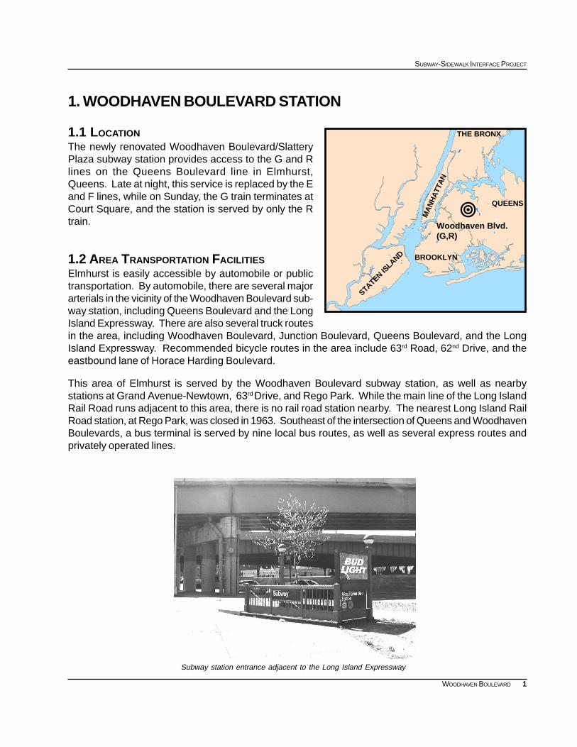
1 SUBWAY-SIDEWALK INTERFACE PROJECT WOODHAVEN BOULEVARD 1. WOODHAVEN BOULEVARD STATION 1.1 LOCATION The newly renovated Woodhaven Boulevard/Slattery Plaza subway station provides access to the G and R lines on the Queens Boulevard line in Elmhurst, Queens. Late at night, this service is replaced by the E and F lines, while on Sunday, the G train terminates at Court Square, and the station is served by only the R train. 1.2 AREA TRANSPORTATION FACILITIES Elmhurst is easily accessible by automobile or public transportation. By automobile, there are several major arterials in the vicinity of the Woodhaven Boulevard sub- way station, including Queens Boulevard and the Long Island Expressway. There are also several truck routes in the area, including Woodhaven Boulevard, Junction Boulevard, Queens Boulevard, and the Long Island Expressway. Recommended bicycle routes in the area include 63 rd Road, 62 nd Drive, and the eastbound lane of Horace Harding Boulevard. This area of Elmhurst is served by the Woodhaven Boulevard subway station, as well as nearby stations at Grand Avenue-Newtown, 63 rd Drive, and Rego Park. While the main line of the Long Island Rail Road runs adjacent to this area, there is no rail road station nearby. The nearest Long Island Rail Road station, at Rego Park, was closed in 1963. Southeast of the intersection of Queens and Woodhaven Boulevards, a bus terminal is served by nine local bus routes, as well as several express routes and privately operated lines. Subway station entrance adjacent to the Long Island Expressway ! Woodhaven Blvd. (G,R) BROOKLYN STATEN ISLAND MANHATTAN QUEENS THE BRONX
Transcript of 1. WOODHAVEN BOULEVARD STATION - Home | · PDF file1. woodhaven boulevard station 1.1 location...
1
SUBWAY-SIDEWALK INTERFACE PROJECT
WOODHAVEN BOULEVARD
1. WOODHAVEN BOULEVARD STATION
1.1 LOCATIONThe newly renovated Woodhaven Boulevard/SlatteryPlaza subway station provides access to the G and Rlines on the Queens Boulevard line in Elmhurst,Queens. Late at night, this service is replaced by the Eand F lines, while on Sunday, the G train terminates atCourt Square, and the station is served by only the Rtrain.
1.2 AREA TRANSPORTATION FACILITIESElmhurst is easily accessible by automobile or publictransportation. By automobile, there are several majorarterials in the vicinity of the Woodhaven Boulevard sub-way station, including Queens Boulevard and the LongIsland Expressway. There are also several truck routesin the area, including Woodhaven Boulevard, Junction Boulevard, Queens Boulevard, and the LongIsland Expressway. Recommended bicycle routes in the area include 63rd Road, 62nd Drive, and theeastbound lane of Horace Harding Boulevard.
This area of Elmhurst is served by the Woodhaven Boulevard subway station, as well as nearbystations at Grand Avenue-Newtown, 63rd Drive, and Rego Park. While the main line of the Long IslandRail Road runs adjacent to this area, there is no rail road station nearby. The nearest Long Island RailRoad station, at Rego Park, was closed in 1963. Southeast of the intersection of Queens and WoodhavenBoulevards, a bus terminal is served by nine local bus routes, as well as several express routes andprivately operated lines.
Subway station entrance adjacent to the Long Island Expressway
!Woodhaven Blvd.(G,R)
BROOKLYN
STATEN ISLAND
MA
NH
ATT
AN
QUEENS
THE BRONX
2
EXISTING CONDITIONS
WOODHAVEN BOULEVARD
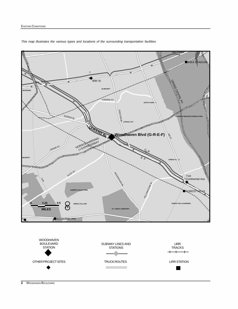
This map illustrates the various types and locations of the surrounding transportation facilities
SUBWAY LINES ANDSTATIONS
WOODHAVENBOULEVARD
STATIONLIRR
TRACKS
LIRR STATIONTRUCK ROUTESOTHER PROJECT SITES
FOREST HILLS GARDENS
FOREST HILLS
MIDDLE VILLAGE
SOUTH CORONA
ELMHURST
REGO PARK
LEFRAK CITY
WOODSIDE
MASPETH
""""
"""" """"""""
""""""""""""
""""
""""
""""
""""
""""
""""
""""
""""
""""
""""
""""
#
#
#
0
QUEENS BL
0.25
MILES
0.5
YE
LLO
WS
TON
E B
L
JUN
CT
ION
BL
108 ST
CORONA AV
ELIOT AV
1146
QUEENS BL
GRAND AV
WO
OD
HAVEN
BL
7
G R
E F
HORACE HARDING-
LI EXPRESSWAY
GR
AN
D C
EN
TRL P
Y
FOREST HILLS
Woodhaven Blvd (G-R-E-F)
90th St
Metropolitan Ave
71stContinental Ave
FLUSHING MEADOW-CORONA PARK
SHEA STADIUM
JUNIPER VALLEY PARK
ST. JOHN’S CEMETERY
SHEA STADIUM
8N
3
SUBWAY-SIDEWALK INTERFACE PROJECT
WOODHAVEN BOULEVARD
AGE DISTRIBUTION: 1990
% of PopulationAge/Years
5.8%0-5
4.7%6-11
4.2%12-16
5.9%17-21
64.6%22-64
5.1%65-69
3.6%70-74
3.5%75-79
1.5%80-84
1.1%85 +
0-21 (20.69%)65+ (14.75%)
22-64 (64.56%)
QN MIDTOWN EXWYEXIT
QN MIDTOWN EXWYEXIT
BOOTH STWETHEROLE ST
94 ST
SAUNDERS ST
93 ST
WO
OD
HA
VE
N B
LVD
SEABURY ST
HOFFMAN DR
QN MIDTOWN EXWY
HOR HARDING EXWY
QUEENS BLVD
59 AV
JUN
CTIO
N B
LVD57 AV
56 AV 90 ST
92 ST
ELIOT AV 62 D
R
WOODHAVEN BLVD
ST
AV
N LINE
54 AV
86 ST
AV
H
Y
HOR HARDIN
G EXWY EN EB
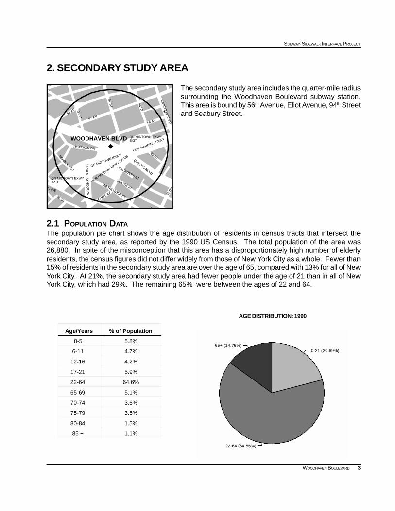
2. SECONDARY STUDY AREA
The secondary study area includes the quarter-mile radiussurrounding the Woodhaven Boulevard subway station.This area is bound by 56th Avenue, Eliot Avenue, 94th Streetand Seabury Street.
2.1 POPULATION DATAThe population pie chart shows the age distribution of residents in census tracts that intersect thesecondary study area, as reported by the 1990 US Census. The total population of the area was26,880. In spite of the misconception that this area has a disproportionately high number of elderlyresidents, the census figures did not differ widely from those of New York City as a whole. Fewer than15% of residents in the secondary study area are over the age of 65, compared with 13% for all of NewYork City. At 21%, the secondary study area had fewer people under the age of 21 than in all of NewYork City, which had 29%. The remaining 65% were between the ages of 22 and 64.
4
EXISTING CONDITIONS
WOODHAVEN BOULEVARD
0 2000 4000 6000 8000 Daily Number of Trips
Bicycle
Taxicab
Other
Railroad
Worked at Home
Bus or Trolleybus
Carpool
Walked
Car, Truck, or Van
Subway or Elevated
Journey to Work Reverse Journey to Work
JOURNEY TO WORK: 1990 Woodhaven Secondary Study Area
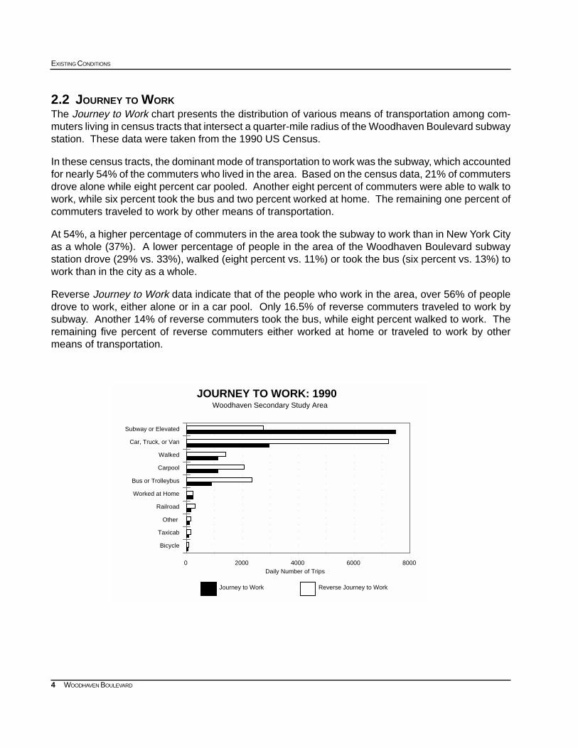
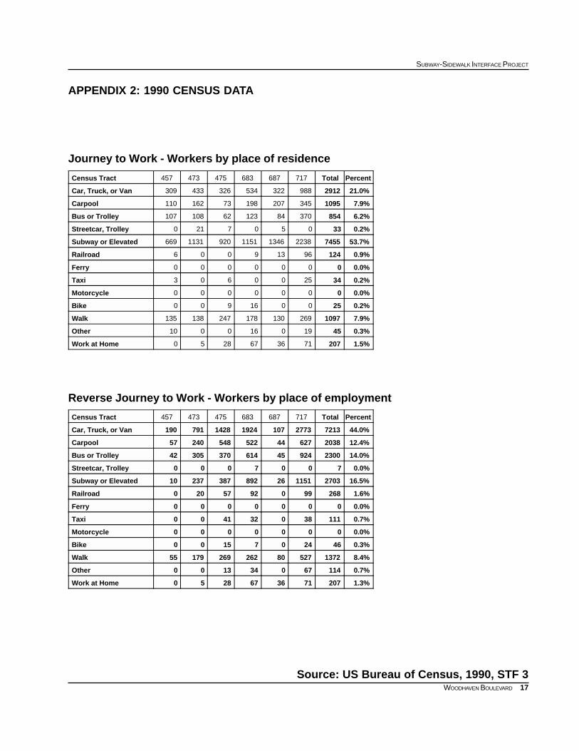
2.2 JOURNEY TO WORKThe Journey to Work chart presents the distribution of various means of transportation among com-muters living in census tracts that intersect a quarter-mile radius of the Woodhaven Boulevard subwaystation. These data were taken from the 1990 US Census.
In these census tracts, the dominant mode of transportation to work was the subway, which accountedfor nearly 54% of the commuters who lived in the area. Based on the census data, 21% of commutersdrove alone while eight percent car pooled. Another eight percent of commuters were able to walk towork, while six percent took the bus and two percent worked at home. The remaining one percent ofcommuters traveled to work by other means of transportation.
At 54%, a higher percentage of commuters in the area took the subway to work than in New York Cityas a whole (37%). A lower percentage of people in the area of the Woodhaven Boulevard subwaystation drove (29% vs. 33%), walked (eight percent vs. 11%) or took the bus (six percent vs. 13%) towork than in the city as a whole.
Reverse Journey to Work data indicate that of the people who work in the area, over 56% of peopledrove to work, either alone or in a car pool. Only 16.5% of reverse commuters traveled to work bysubway. Another 14% of reverse commuters took the bus, while eight percent walked to work. Theremaining five percent of reverse commuters either worked at home or traveled to work by othermeans of transportation.
5
SUBWAY-SIDEWALK INTERFACE PROJECT
WOODHAVEN BOULEVARD
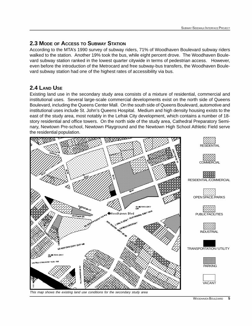
This map shows the existing land use conditions for the secondary study area
RESIDENTIAL /COMMERCIAL
RESIDENTIAL
COMMERCIAL
OPEN SPACE /PARKS
PUBLIC FACILITIES
INDUSTRIAL
PARKING
VACANT
TRANSPORTATION / UTILITY
2.3 MODE OF ACCESS TO SUBWAY STATIONAccording to the MTA’s 1990 survey of subway riders, 71% of Woodhaven Boulevard subway riderswalked to the station. Another 19% took the bus, while eight percent drove. The Woodhaven Boule-vard subway station ranked in the lowest quarter citywide in terms of pedestrian access. However,even before the introduction of the Metrocard and free subway-bus transfers, the Woodhaven Boule-vard subway station had one of the highest rates of accessibility via bus.
2.4 LAND USEExisting land use in the secondary study area consists of a mixture of residential, commercial andinstitutional uses. Several large-scale commercial developments exist on the north side of QueensBoulevard, including the Queens Center Mall. On the south side of Queens Boulevard, automotive andinstitutional uses include St. John’s Queens Hospital. Medium and high density housing exists to theeast of the study area, most notably in the Lefrak City development, which contains a number of 18-story residential and office towers. On the north side of the study area, Cathedral Preparatory Semi-nary, Newtown Pre-school, Newtown Playground and the Newtown High School Athletic Field servethe residential population.
6
EXISTING CONDITIONS
WOODHAVEN BOULEVARD
2.5 ZONING AND DEVELOPMENTZoning in the study area consists of a mixture of C4-2 and C8-1 commercial and R6 medium densityresidential zoning districts. A number of development proposals are pending which would impact thetransportation infrastructure of the study area.
The Macerich Company’s proposal to expand the QueensCenter Mall is currently pending ULURP approval. Thisproposal would displace the full block between 57th-59th
Avenues and 92nd-94th Streets, which is currently usedas a municipal parking lot, and would rezone a portion ofthe study area to C4-5x, permitting uniform large scalecommercial development.
The Mattone Group’s proposal to build a 4,200 seat LoewsMultiplex movie theater and a 650 car parking garage re-cently received the approval of its ULURP application.This development will displace a full-block municipal park-ing lot which exists between 59th-60th Avenues and 92nd-94th Streets, which is currently used as a park and ridefacility. While three special permits and the dispositionof city-owned property were approved through the UL-URP process, no rezoning was required for this as-of-right development.
Other potential development sites on the north side of Queens Boulevard include the Georgia Dinersite and the expansion of the Sterns Department Store site, which would encompass a number of retailuses to be completed in mid 2001. On the south side of Queens Boulevard, the Sears Auto Centerwas recently completed.
2.6 ORGANIZATIONS AND ON-GOING PROJECTSThe Queens Borough President’s Office has organized the Queens Boulevard Working Group, toaddress transportation and safety concerns on Queens With technical support from the New York CityDepartment of City Planning, this group commissioned the Queens Boulevard Pedestrian Safety Study,which proposes a number of recommendations for the areas immediately to the east of the study area.Other active community groups in the area include the Lefrak City Association and the Newtown CivicAssociation.
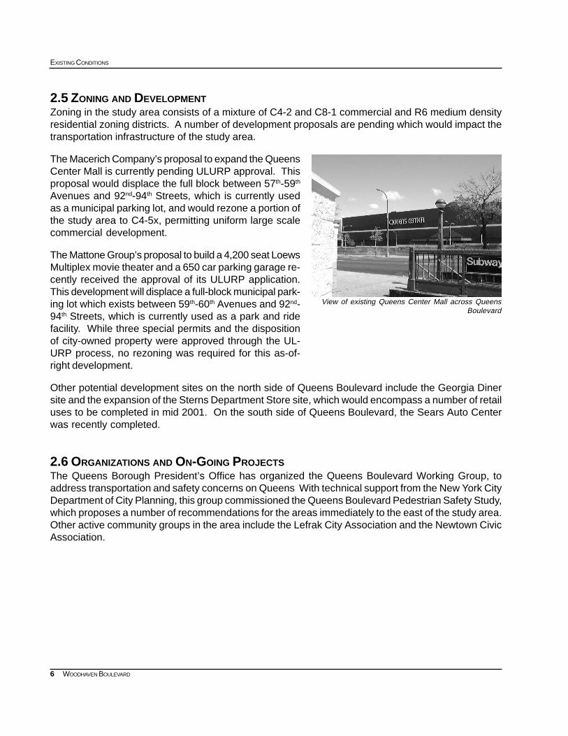
View of existing Queens Center Mall across QueensBoulevard
7
SUBWAY-SIDEWALK INTERFACE PROJECT
WOODHAVEN BOULEVARD
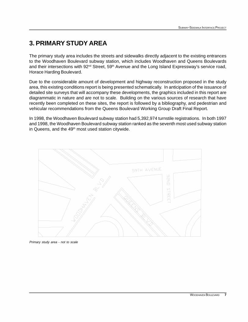
Primary study area - not to scale
3. PRIMARY STUDY AREA
The primary study area includes the streets and sidewalks directly adjacent to the existing entrancesto the Woodhaven Boulevard subway station, which includes Woodhaven and Queens Boulevardsand their intersections with 92nd Street, 59th Avenue and the Long Island Expressway’s service road,Horace Harding Boulevard.
Due to the considerable amount of development and highway reconstruction proposed in the studyarea, this existing conditions report is being presented schematically. In anticipation of the issuance ofdetailed site surveys that will accompany these developments, the graphics included in this report arediagrammatic in nature and are not to scale. Building on the various sources of research that haverecently been completed on these sites, the report is followed by a bibliography, and pedestrian andvehicular recommendations from the Queens Boulevard Working Group Draft Final Report.
In 1998, the Woodhaven Boulevard subway station had 5,392,974 turnstile registrations. In both 1997and 1998, the Woodhaven Boulevard subway station ranked as the seventh most used subway stationin Queens, and the 49th most used station citywide.
8
EXISTING CONDITIONS
WOODHAVEN BOULEVARD
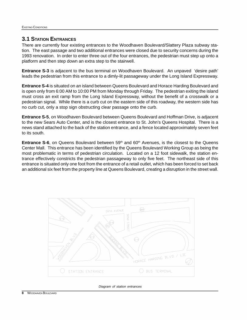
Diagram of station entrances
3.1 STATION ENTRANCESThere are currently four existing entrances to the Woodhaven Boulevard/Slattery Plaza subway sta-tion. The east passage and two additional entrances were closed due to security concerns during the1993 renovation. In order to enter three out of the four entrances, the pedestrian must step up onto aplatform and then step down an extra step to the stairwell.
Entrance S-3 is adjacent to the bus terminal on Woodhaven Boulevard. An unpaved ‘desire path’leads the pedestrian from this entrance to a dimly-lit passageway under the Long Island Expressway.
Entrance S-4 is situated on an island between Queens Boulevard and Horace Harding Boulevard andis open only from 6:00 AM to 10:00 PM from Monday through Friday. The pedestrian exiting the islandmust cross an exit ramp from the Long Island Expressway, without the benefit of a crosswalk or apedestrian signal. While there is a curb cut on the eastern side of this roadway, the western side hasno curb cut, only a stop sign obstructing clear passage onto the curb.
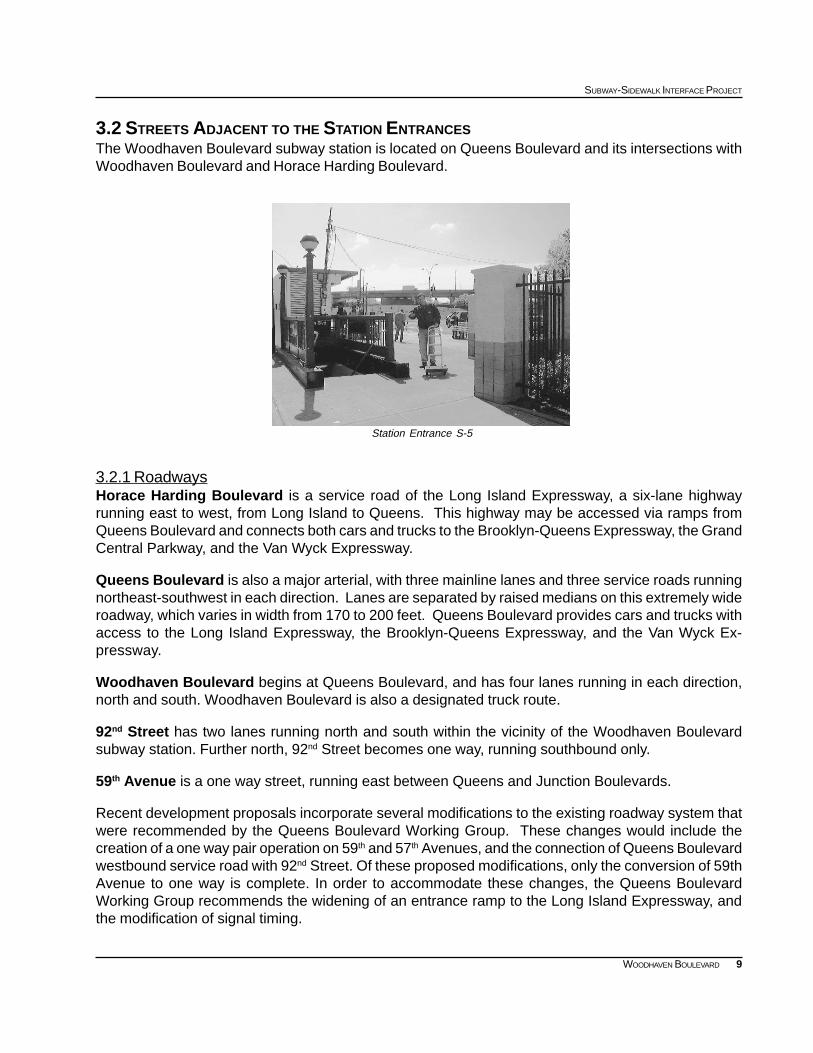
Entrance S-5, on Woodhaven Boulevard between Queens Boulevard and Hoffman Drive, is adjacentto the new Sears Auto Center, and is the closest entrance to St. John’s Queens Hospital. There is anews stand attached to the back of the station entrance, and a fence located approximately seven feetto its south.
Entrance S-6, on Queens Boulevard between 59th and 60th Avenues, is the closest to the QueensCenter Mall. This entrance has been identified by the Queens Boulevard Working Group as being themost problematic in terms of pedestrian circulation. Located on a 12 foot sidewalk, the station en-trance effectively constricts the pedestrian passageway to only five feet. The northeast side of thisentrance is situated only one foot from the entrance of a retail outlet, which has been forced to set backan additional six feet from the property line at Queens Boulevard, creating a disruption in the street wall.
9
SUBWAY-SIDEWALK INTERFACE PROJECT
WOODHAVEN BOULEVARD
3.2 STREETS ADJACENT TO THE STATION ENTRANCESThe Woodhaven Boulevard subway station is located on Queens Boulevard and its intersections withWoodhaven Boulevard and Horace Harding Boulevard.
3.2.1 RoadwaysHorace Harding Boulevard is a service road of the Long Island Expressway, a six-lane highwayrunning east to west, from Long Island to Queens. This highway may be accessed via ramps fromQueens Boulevard and connects both cars and trucks to the Brooklyn-Queens Expressway, the GrandCentral Parkway, and the Van Wyck Expressway.
Queens Boulevard is also a major arterial, with three mainline lanes and three service roads runningnortheast-southwest in each direction. Lanes are separated by raised medians on this extremely wideroadway, which varies in width from 170 to 200 feet. Queens Boulevard provides cars and trucks withaccess to the Long Island Expressway, the Brooklyn-Queens Expressway, and the Van Wyck Ex-pressway.
Woodhaven Boulevard begins at Queens Boulevard, and has four lanes running in each direction,north and south. Woodhaven Boulevard is also a designated truck route.
92nd Street has two lanes running north and south within the vicinity of the Woodhaven Boulevardsubway station. Further north, 92nd Street becomes one way, running southbound only.
59th Avenue is a one way street, running east between Queens and Junction Boulevards.
Recent development proposals incorporate several modifications to the existing roadway system thatwere recommended by the Queens Boulevard Working Group. These changes would include thecreation of a one way pair operation on 59th and 57th Avenues, and the connection of Queens Boulevardwestbound service road with 92nd Street. Of these proposed modifications, only the conversion of 59thAvenue to one way is complete. In order to accommodate these changes, the Queens BoulevardWorking Group recommends the widening of an entrance ramp to the Long Island Expressway, andthe modification of signal timing.
Station Entrance S-5
10
EXISTING CONDITIONS
WOODHAVEN BOULEVARD
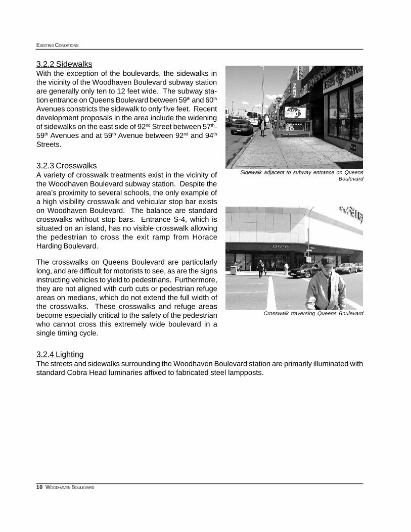
3.2.2 SidewalksWith the exception of the boulevards, the sidewalks inthe vicinity of the Woodhaven Boulevard subway stationare generally only ten to 12 feet wide. The subway sta-tion entrance on Queens Boulevard between 59th and 60th
Avenues constricts the sidewalk to only five feet. Recentdevelopment proposals in the area include the wideningof sidewalks on the east side of 92nd Street between 57th-59th Avenues and at 59th Avenue between 92nd and 94th
Streets.
3.2.3 CrosswalksA variety of crosswalk treatments exist in the vicinity ofthe Woodhaven Boulevard subway station. Despite thearea’s proximity to several schools, the only example ofa high visibility crosswalk and vehicular stop bar existson Woodhaven Boulevard. The balance are standardcrosswalks without stop bars. Entrance S-4, which issituated on an island, has no visible crosswalk allowingthe pedestrian to cross the exit ramp from HoraceHarding Boulevard.
The crosswalks on Queens Boulevard are particularlylong, and are difficult for motorists to see, as are the signsinstructing vehicles to yield to pedestrians. Furthermore,they are not aligned with curb cuts or pedestrian refugeareas on medians, which do not extend the full width ofthe crosswalks. These crosswalks and refuge areasbecome especially critical to the safety of the pedestrianwho cannot cross this extremely wide boulevard in asingle timing cycle.
3.2.4 LightingThe streets and sidewalks surrounding the Woodhaven Boulevard station are primarily illuminated withstandard Cobra Head luminaries affixed to fabricated steel lampposts.
Crosswalk traversing Queens Boulevard
Sidewalk adjacent to subway entrance on QueensBoulevard
11
SUBWAY-SIDEWALK INTERFACE PROJECT
WOODHAVEN BOULEVARD
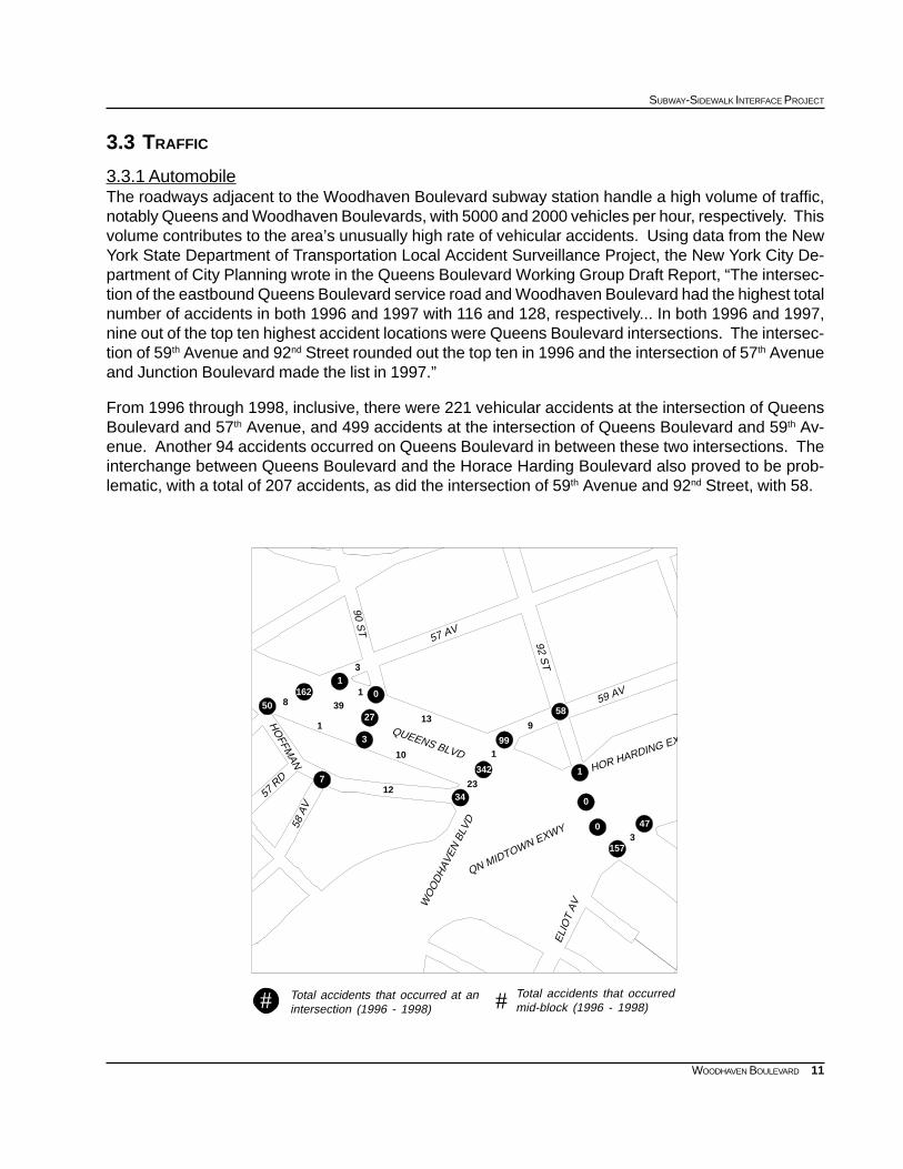
Total accidents that occurred at anintersection (1996 - 1998)# Total accidents that occurred
mid-block (1996 - 1998)#
0
0
157
473
58
1
9
34
342
23
199
12
10
13
0
27
3
1
7
3
1
39
1
16250 8
HO
FFMAN
QUEENS BLVD
58 A
V
57 R
D
WO
OD
HAV
EN B
LVD
ELI
OT
AV
QN MIDTOWN EXWY
90 ST
57 AV
HOR HARDING EX
59 AV
92 ST
3.3 TRAFFIC
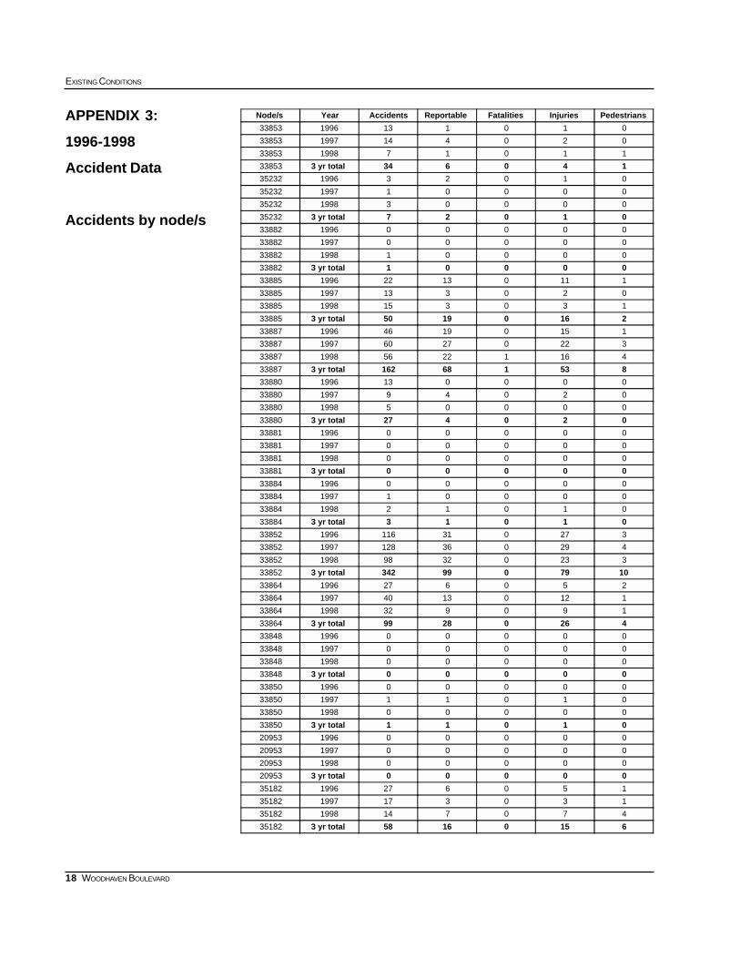
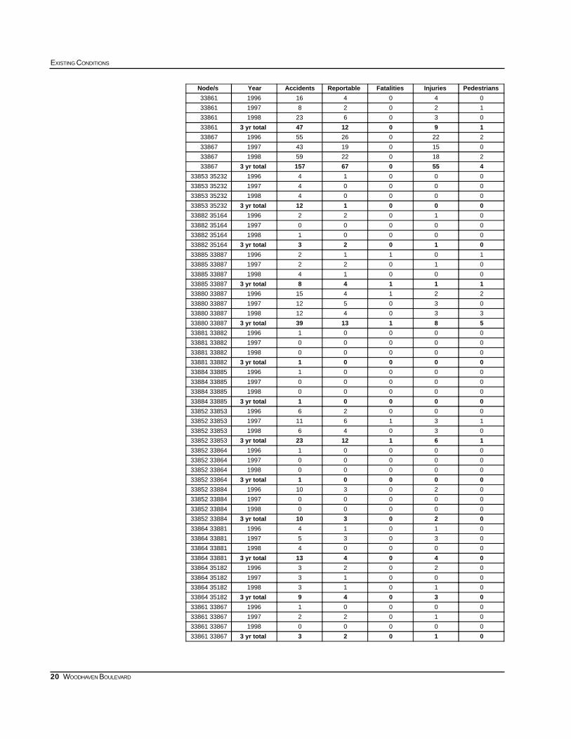
3.3.1 AutomobileThe roadways adjacent to the Woodhaven Boulevard subway station handle a high volume of traffic,notably Queens and Woodhaven Boulevards, with 5000 and 2000 vehicles per hour, respectively. Thisvolume contributes to the area’s unusually high rate of vehicular accidents. Using data from the NewYork State Department of Transportation Local Accident Surveillance Project, the New York City De-partment of City Planning wrote in the Queens Boulevard Working Group Draft Report, “The intersec-tion of the eastbound Queens Boulevard service road and Woodhaven Boulevard had the highest totalnumber of accidents in both 1996 and 1997 with 116 and 128, respectively... In both 1996 and 1997,nine out of the top ten highest accident locations were Queens Boulevard intersections. The intersec-tion of 59th Avenue and 92nd Street rounded out the top ten in 1996 and the intersection of 57th Avenueand Junction Boulevard made the list in 1997.”
From 1996 through 1998, inclusive, there were 221 vehicular accidents at the intersection of QueensBoulevard and 57th Avenue, and 499 accidents at the intersection of Queens Boulevard and 59th Av-enue. Another 94 accidents occurred on Queens Boulevard in between these two intersections. Theinterchange between Queens Boulevard and the Horace Harding Boulevard also proved to be prob-lematic, with a total of 207 accidents, as did the intersection of 59th Avenue and 92nd Street, with 58.
12
EXISTING CONDITIONS
WOODHAVEN BOULEVARD
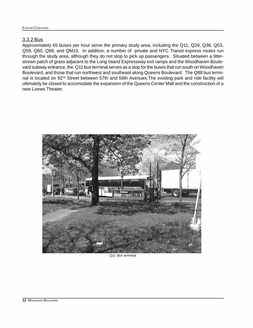
3.3.2 BusApproximately 65 buses per hour serve the primary study area, including the Q11, Q29, Q38, Q53,Q59, Q60, Q88, and QM10. In addition, a number of private and NYC Transit express routes runthrough the study area, although they do not stop to pick up passengers. Situated between a litter-strewn patch of grass adjacent to the Long Island Expressway exit ramps and the Woodhaven Boule-vard subway entrance, the Q11 bus terminal serves as a stop for the buses that run south on WoodhavenBoulevard, and those that run northwest and southeast along Queens Boulevard. The Q88 bus termi-nal is located on 92nd Street between 57th and 59th Avenues.The existing park and ride facility willultimately be closed to accomodate the expansion of the Queens Center Mall and the construction of anew Loews Theater.
Q11 Bus terminal
13
SUBWAY-SIDEWALK INTERFACE PROJECT
WOODHAVEN BOULEVARD
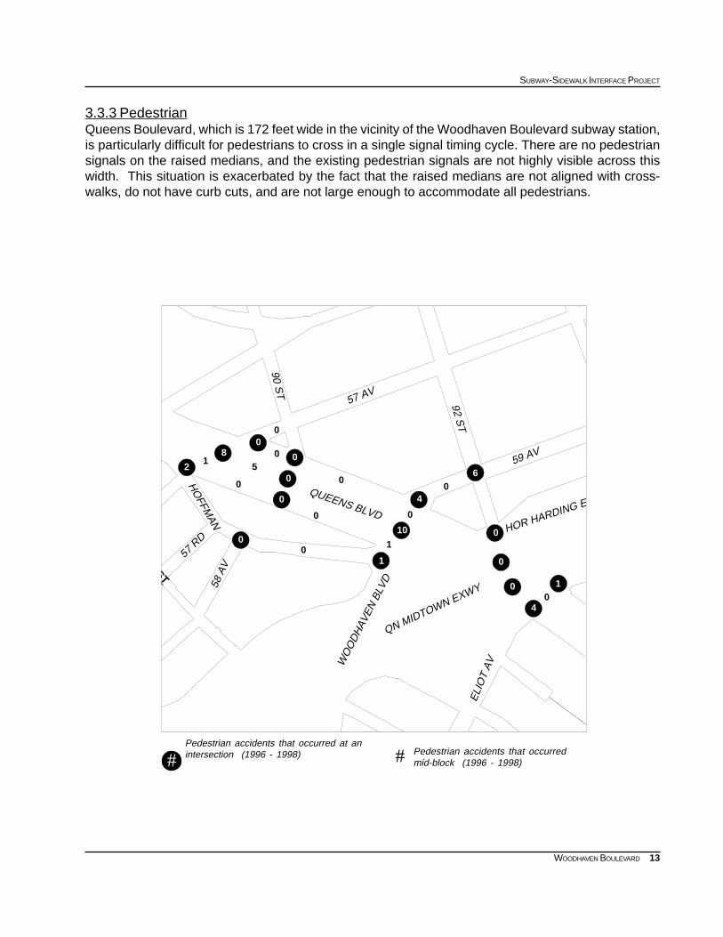
3.3.3 PedestrianQueens Boulevard, which is 172 feet wide in the vicinity of the Woodhaven Boulevard subway station,is particularly difficult for pedestrians to cross in a single signal timing cycle. There are no pedestriansignals on the raised medians, and the existing pedestrian signals are not highly visible across thiswidth. This situation is exacerbated by the fact that the raised medians are not aligned with cross-walks, do not have curb cuts, and are not large enough to accommodate all pedestrians.
#
Pedestrian accidents that occurred at anintersection (1996 - 1998) Pedestrian accidents that occurred
mid-block (1996 - 1998)##
0
00
4
1
0
60
4
0
1
10
1
0
0
0
0
0
0
0
05
0
0
0
8
21
QUEENS BLVD
WO
OD
HAV
EN B
LVD
HO
FFMAN
58 A
V
57 R
D
ELI
OT
AV
QN MIDTOWN EXWY
90 ST
57 AV
HOR HARDING E
59 AV
92 ST
ST
14
EXISTING CONDITIONS
WOODHAVEN BOULEVARD
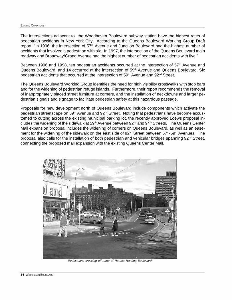
The intersections adjacent to the Woodhaven Boulevard subway station have the highest rates ofpedestrian accidents in New York City. According to the Queens Boulevard Working Group Draftreport, “In 1996, the intersection of 57th Avenue and Junction Boulevard had the highest number ofaccidents that involved a pedestrian with six. In 1997, the intersection of the Queens Boulevard mainroadway and Broadway/Grand Avenue had the highest number of pedestrian accidents with five.”
Between 1996 and 1998, ten pedestrian accidents occurred at the intersection of 57th Avenue andQueens Boulevard, and 14 occurred at the intersection of 59th Avenue and Queens Boulevard. Sixpedestrian accidents that occurred at the intersection of 59th Avenue and 92nd Street.
The Queens Boulevard Working Group identifies the need for high visibility crosswalks with stop barsand for the widening of pedestrian refuge islands. Furthermore, their report recommends the removalof inappropriately placed street furniture at corners, and the installation of neckdowns and larger pe-destrian signals and signage to facilitate pedestrian safety at this hazardous passage.
Proposals for new development north of Queens Boulevard include components which activate thepedestrian streetscape on 59th Avenue and 92nd Street. Noting that pedestrians have become accus-tomed to cutting across the existing municipal parking lot, the recently approved Loews proposal in-cludes the widening of the sidewalk at 59th Avenue between 92nd and 94th Streets. The Queens CenterMall expansion proposal includes the widening of corners on Queens Boulevard, as well as an ease-ment for the widening of the sidewalk on the east side of 92nd Street between 57th-59th Avenues. Theproposal also calls for the installation of both pedestrian and vehicular bridges spanning 92nd Street,connecting the proposed mall expansion with the existing Queens Center Mall.
Pedestrians crossing off-ramp of Horace Harding Boulevard
15
SUBWAY-SIDEWALK INTERFACE PROJECT
WOODHAVEN BOULEVARD
WOODHAVEN BOULEVARD APPENDICES
APPENDIX 1: 1990 CENSUS DATA
Population Data by Age and Census Tract
APPENDIX 2: 1990 CENSUS DATA
Journey to Work - Workers by place of residence
Reverse Journey to Work - Workers by place of employment
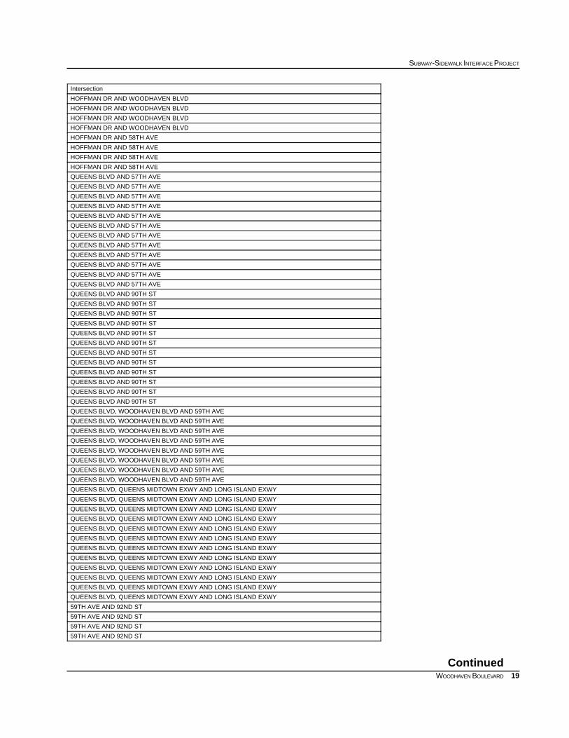
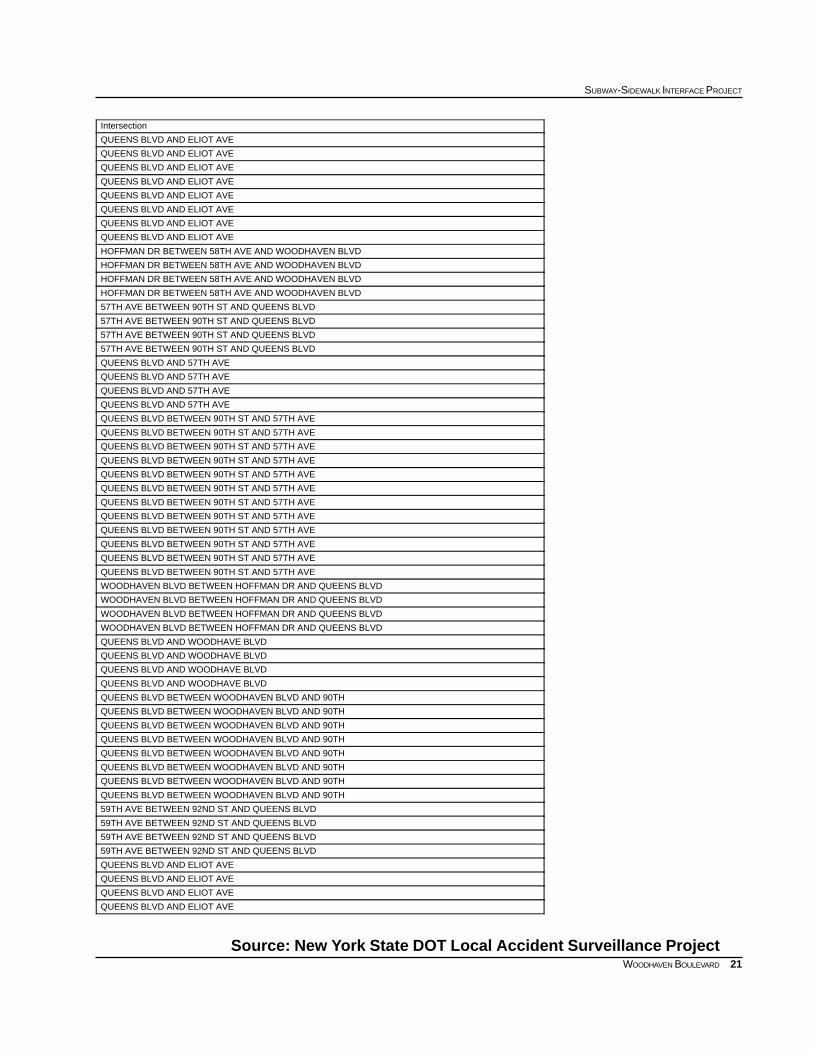
APPENDIX 3: 1996-1998 ACCIDENT DATA
Accidents by Node/s
APPENDIX 4: SIGNAL TIMING DATA
APPENDIX 5: QUEENS BOULEVARD WORKING GROUP DRAFT FINAL REPORT
Vehicular Recommendations
Pedestrian Recommendations
APPENDIX 6: BIBLIOGRAPHY
APPENDIX 7: INVENTORY OF EXISTING CONDITIONS
16
EXISTING CONDITIONS
WOODHAVEN BOULEVARD
Population data by age
APPENDIX 1: 1990 CENSUS DATA
Source: US Bureau of Census, 1990, STF 3
85+ yrs80-84 yrs75-79 yrs70-74 yrs65-69 yrs22-64 yrs17-21 yrs12-16 yrs6-11 yrs0-5 yrsTotalTract
123490631101718248109147982629457
325211911312224142741151722493662473
173913314315221462181771641933382475
1917813417928902562002533344344683
588215516719925492421541932484047687
14819137235559656373603633444508816717
286399947975135817354159811181273157226880People
1.1%1.5%3.5%3.6%5.1%64.6%5.9%4.2%4.7%5.8%100%Percent
687
717475
683
457
473
Woodhaven Blvd
17
SUBWAY-SIDEWALK INTERFACE PROJECT
WOODHAVEN BOULEVARD
Journey to Work - Workers by place of residence
Reverse Journey to Work - Workers by place of employment
APPENDIX 2: 1990 CENSUS DATA
Source: US Bureau of Census, 1990, STF 3
PercentTotal717687683475473457Census Tract
21.0%2912988322534326433309Car, Truck, or Van
7.9%109534520719873162110Carpool
6.2%8543708412362108107Bus or Trolley
0.2%330507210Streetcar, Trolley
53.7%74552238134611519201131669Subway or Elevated
0.9%12496139006Railroad
0.0%0000000Ferry
0.2%342500603Taxi
0.0%0000000Motorcycle
0.2%250016900Bike
7.9%1097269130178247138135Walk
0.3%45190160010Other
1.5%2077136672850Work at Home
PercentTotal717687683475473457Census Tract
44.0%7213277310719241428791190Car, Truck, or Van
12.4%20386274452254824057Carpool
14.0%23009244561437030542Bus or Trolley
0.0%7007000Streetcar, Trolley
16.5%270311512689238723710Subway or Elevated
1.6%2689909257200Railroad
0.0%0000000Ferry
0.7%111380324100Taxi
0.0%0000000Motorcycle
0.3%4624071500Bike
8.4%13725278026226917955Walk
0.7%114670341300Other
1.3%2077136672850Work at Home
18
EXISTING CONDITIONS
WOODHAVEN BOULEVARD
APPENDIX 3:
1996-1998
Accident Data
Accidents by node/s
PedestriansInjuriesFatalitiesReportableAccidentsYearNode/s
010113199633853
020414199733853
11017199833853
1406343 yr total33853
01023199635232
00001199735232
00003199835232
010273 yr total35232
00000199633882
00000199733882
00001199833882
000013 yr total33882
11101322199633885
020313199733885
130315199833885
216019503 yr total33885
11501946199633887
32202760199733887
41612256199833887
8531681623 yr total33887
000013199633880
02049199733880
00005199833880
0204273 yr total33880
00000199633881
00000199733881
00000199833881
000003 yr total33881
00000199633884
00001199733884
01012199833884
010133 yr total33884
327031116199633852
429036128199733852
32303298199833852
10790993423 yr total33852
250627199633864
11201340199733864
190932199833864
426028993 yr total33864
00000199633848
00000199733848
00000199833848
000003 yr total33848
00000199633850
01011199733850
00000199833850
010113 yr total33850
00000199620953
00000199720953
00000199820953
000003 yr total20953
150627199635182
130317199735182
470714199835182
615016583 yr total35182
19
SUBWAY-SIDEWALK INTERFACE PROJECT
WOODHAVEN BOULEVARD
Continued
Intersection
HOFFMAN DR AND WOODHAVEN BLVD
HOFFMAN DR AND WOODHAVEN BLVD
HOFFMAN DR AND WOODHAVEN BLVD
HOFFMAN DR AND WOODHAVEN BLVD
HOFFMAN DR AND 58TH AVE
HOFFMAN DR AND 58TH AVE
HOFFMAN DR AND 58TH AVE
HOFFMAN DR AND 58TH AVE
QUEENS BLVD AND 57TH AVE
QUEENS BLVD AND 57TH AVE
QUEENS BLVD AND 57TH AVE
QUEENS BLVD AND 57TH AVE
QUEENS BLVD AND 57TH AVE
QUEENS BLVD AND 57TH AVE
QUEENS BLVD AND 57TH AVE
QUEENS BLVD AND 57TH AVE
QUEENS BLVD AND 57TH AVE
QUEENS BLVD AND 57TH AVE
QUEENS BLVD AND 57TH AVE
QUEENS BLVD AND 57TH AVE
QUEENS BLVD AND 90TH ST
QUEENS BLVD AND 90TH ST
QUEENS BLVD AND 90TH ST
QUEENS BLVD AND 90TH ST
QUEENS BLVD AND 90TH ST
QUEENS BLVD AND 90TH ST
QUEENS BLVD AND 90TH ST
QUEENS BLVD AND 90TH ST
QUEENS BLVD AND 90TH ST
QUEENS BLVD AND 90TH ST
QUEENS BLVD AND 90TH ST
QUEENS BLVD AND 90TH ST
QUEENS BLVD, WOODHAVEN BLVD AND 59TH AVE
QUEENS BLVD, WOODHAVEN BLVD AND 59TH AVE
QUEENS BLVD, WOODHAVEN BLVD AND 59TH AVE
QUEENS BLVD, WOODHAVEN BLVD AND 59TH AVE
QUEENS BLVD, WOODHAVEN BLVD AND 59TH AVE
QUEENS BLVD, WOODHAVEN BLVD AND 59TH AVE
QUEENS BLVD, WOODHAVEN BLVD AND 59TH AVE
QUEENS BLVD, WOODHAVEN BLVD AND 59TH AVE
QUEENS BLVD, QUEENS MIDTOWN EXWY AND LONG ISLAND EXWY
QUEENS BLVD, QUEENS MIDTOWN EXWY AND LONG ISLAND EXWY
QUEENS BLVD, QUEENS MIDTOWN EXWY AND LONG ISLAND EXWY
QUEENS BLVD, QUEENS MIDTOWN EXWY AND LONG ISLAND EXWY
QUEENS BLVD, QUEENS MIDTOWN EXWY AND LONG ISLAND EXWY
QUEENS BLVD, QUEENS MIDTOWN EXWY AND LONG ISLAND EXWY
QUEENS BLVD, QUEENS MIDTOWN EXWY AND LONG ISLAND EXWY
QUEENS BLVD, QUEENS MIDTOWN EXWY AND LONG ISLAND EXWY
QUEENS BLVD, QUEENS MIDTOWN EXWY AND LONG ISLAND EXWY
QUEENS BLVD, QUEENS MIDTOWN EXWY AND LONG ISLAND EXWY
QUEENS BLVD, QUEENS MIDTOWN EXWY AND LONG ISLAND EXWY
QUEENS BLVD, QUEENS MIDTOWN EXWY AND LONG ISLAND EXWY
59TH AVE AND 92ND ST
59TH AVE AND 92ND ST
59TH AVE AND 92ND ST
59TH AVE AND 92ND ST
20
EXISTING CONDITIONS
WOODHAVEN BOULEVARD
PedestriansInjuriesFatalitiesReportableAccidentsYearNode/s
040416199633861
12028199733861
030623199833861
19012473 yr total33861
22202655199633867
01501943199733867
21802259199833867
4550671573 yr total33867
00014199633853 35232
00004199733853 35232
00004199833853 35232
0001123 yr total33853 35232
01022199633882 35164
00000199733882 35164
00001199833882 35164
010233 yr total33882 35164
10112199633885 33887
01022199733885 33887
00014199833885 33887
111483 yr total33885 33887
221415199633880 33887
030512199733880 33887
330412199833880 33887
58113393 yr total33880 33887
00001199633881 33882
00000199733881 33882
00000199833881 33882
000013 yr total33881 33882
00001199633884 33885
00000199733884 33885
00000199833884 33885
000013 yr total33884 33885
00026199633852 33853
131611199733852 33853
03046199833852 33853
16112233 yr total33852 33853
00001199633852 33864
00000199733852 33864
00000199833852 33864
000013 yr total33852 33864
020310199633852 33884
00000199733852 33884
00000199833852 33884
0203103 yr total33852 33884
01014199633864 33881
03035199733864 33881
00004199833864 33881
0404133 yr total33864 33881
02023199633864 35182
00013199733864 35182
01013199833864 35182
030493 yr total33864 35182
00001199633861 33867
01022199733861 33867
00000199833861 33867
010233 yr total33861 33867
21
SUBWAY-SIDEWALK INTERFACE PROJECT
WOODHAVEN BOULEVARD
Source: New York State DOT Local Accident Surveillance Project
Intersection
QUEENS BLVD AND ELIOT AVE
QUEENS BLVD AND ELIOT AVE
QUEENS BLVD AND ELIOT AVE
QUEENS BLVD AND ELIOT AVE
QUEENS BLVD AND ELIOT AVE
QUEENS BLVD AND ELIOT AVE
QUEENS BLVD AND ELIOT AVE
QUEENS BLVD AND ELIOT AVE
HOFFMAN DR BETWEEN 58TH AVE AND WOODHAVEN BLVD
HOFFMAN DR BETWEEN 58TH AVE AND WOODHAVEN BLVD
HOFFMAN DR BETWEEN 58TH AVE AND WOODHAVEN BLVD
HOFFMAN DR BETWEEN 58TH AVE AND WOODHAVEN BLVD
57TH AVE BETWEEN 90TH ST AND QUEENS BLVD
57TH AVE BETWEEN 90TH ST AND QUEENS BLVD
57TH AVE BETWEEN 90TH ST AND QUEENS BLVD
57TH AVE BETWEEN 90TH ST AND QUEENS BLVD
QUEENS BLVD AND 57TH AVE
QUEENS BLVD AND 57TH AVE
QUEENS BLVD AND 57TH AVE
QUEENS BLVD AND 57TH AVE
QUEENS BLVD BETWEEN 90TH ST AND 57TH AVE
QUEENS BLVD BETWEEN 90TH ST AND 57TH AVE
QUEENS BLVD BETWEEN 90TH ST AND 57TH AVE
QUEENS BLVD BETWEEN 90TH ST AND 57TH AVE
QUEENS BLVD BETWEEN 90TH ST AND 57TH AVE
QUEENS BLVD BETWEEN 90TH ST AND 57TH AVE
QUEENS BLVD BETWEEN 90TH ST AND 57TH AVE
QUEENS BLVD BETWEEN 90TH ST AND 57TH AVE
QUEENS BLVD BETWEEN 90TH ST AND 57TH AVE
QUEENS BLVD BETWEEN 90TH ST AND 57TH AVE
QUEENS BLVD BETWEEN 90TH ST AND 57TH AVE
QUEENS BLVD BETWEEN 90TH ST AND 57TH AVE
WOODHAVEN BLVD BETWEEN HOFFMAN DR AND QUEENS BLVD
WOODHAVEN BLVD BETWEEN HOFFMAN DR AND QUEENS BLVD
WOODHAVEN BLVD BETWEEN HOFFMAN DR AND QUEENS BLVD
WOODHAVEN BLVD BETWEEN HOFFMAN DR AND QUEENS BLVD
QUEENS BLVD AND WOODHAVE BLVD
QUEENS BLVD AND WOODHAVE BLVD
QUEENS BLVD AND WOODHAVE BLVD
QUEENS BLVD AND WOODHAVE BLVD
QUEENS BLVD BETWEEN WOODHAVEN BLVD AND 90TH
QUEENS BLVD BETWEEN WOODHAVEN BLVD AND 90TH
QUEENS BLVD BETWEEN WOODHAVEN BLVD AND 90TH
QUEENS BLVD BETWEEN WOODHAVEN BLVD AND 90TH
QUEENS BLVD BETWEEN WOODHAVEN BLVD AND 90TH
QUEENS BLVD BETWEEN WOODHAVEN BLVD AND 90TH
QUEENS BLVD BETWEEN WOODHAVEN BLVD AND 90TH
QUEENS BLVD BETWEEN WOODHAVEN BLVD AND 90TH
59TH AVE BETWEEN 92ND ST AND QUEENS BLVD
59TH AVE BETWEEN 92ND ST AND QUEENS BLVD
59TH AVE BETWEEN 92ND ST AND QUEENS BLVD
59TH AVE BETWEEN 92ND ST AND QUEENS BLVD
QUEENS BLVD AND ELIOT AVE
QUEENS BLVD AND ELIOT AVE
QUEENS BLVD AND ELIOT AVE
QUEENS BLVD AND ELIOT AVE
22
EXISTING CONDITIONS
WOODHAVEN BOULEVARD
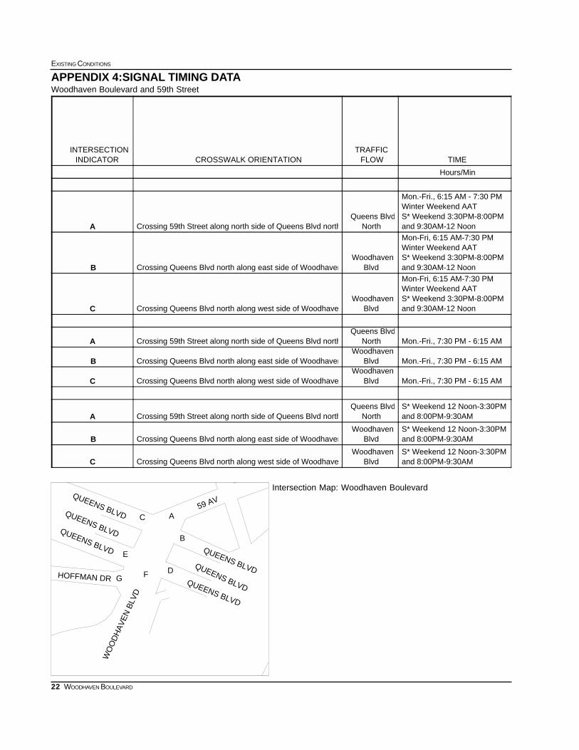
APPENDIX 4:SIGNAL TIMING DATA
A
B
C
D
E
FGHOFFMAN DR
QUEENS BLVD
WO
OD
HA
VE
N B
LVD
QUEENS BLVDQUEENS BLVD
59 AV
QUEENS BLVDQUEENS BLVD
QUEENS BLVD
Woodhaven Boulevard and 59th Street
Intersection Map: Woodhaven Boulevard
TIMEFLOWTRAFFIC
CROSSWALK ORIENTATIONINDICATORINTERSECTION
Hours/Min
and 9:30AM-12 NoonS* Weekend 3:30PM-8:00PM Winter Weekend AAT Mon.-Fri., 6:15 AM - 7:30 PM
NorthQueens Blvd
Crossing 59th Street along north side of Queens Blvd northA
and 9:30AM-12 NoonS* Weekend 3:30PM-8:00PM Winter Weekend AAT Mon-Fri, 6:15 AM-7:30 PM
BlvdWoodhaven
Crossing Queens Blvd north along east side of WoodhavenB
and 9:30AM-12 NoonS* Weekend 3:30PM-8:00PM Winter Weekend AAT Mon-Fri, 6:15 AM-7:30 PM
BlvdWoodhaven
Crossing Queens Blvd north along west side of WoodhaveC
Mon.-Fri., 7:30 PM - 6:15 AM NorthQueens Blvd
Crossing 59th Street along north side of Queens Blvd northA
Mon.-Fri., 7:30 PM - 6:15 AM BlvdWoodhaven
Crossing Queens Blvd north along east side of WoodhavenB
Mon.-Fri., 7:30 PM - 6:15 AM BlvdWoodhaven
Crossing Queens Blvd north along west side of WoodhaveC
and 8:00PM-9:30AMS* Weekend 12 Noon-3:30PM
NorthQueens Blvd
Crossing 59th Street along north side of Queens Blvd northA
and 8:00PM-9:30AMS* Weekend 12 Noon-3:30PM
BlvdWoodhaven
Crossing Queens Blvd north along east side of WoodhavenB
and 8:00PM-9:30AMS* Weekend 12 Noon-3:30PM
BlvdWoodhaven
Crossing Queens Blvd north along west side of WoodhaveC
23
SUBWAY-SIDEWALK INTERFACE PROJECT
WOODHAVEN BOULEVARD
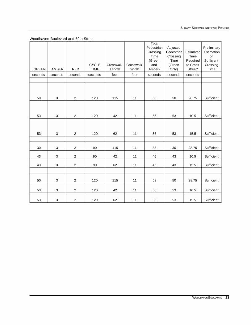
Woodhaven Boulevard and 59th Street
TimeCrossingSufficient
ofEstimationPreliminary
Street*to CrossRequired
TimeEstimated
Only)(GreenTime
CrossingPedestrianAdjusted
Amber)and
(GreenTime
CrossingPedestrian
Total
WidthCrosswalk
LengthCrosswalk
TIMECYCLE
REDAMBERGREEN
secondssecondssecondsfeetfeetsecondssecondssecondsseconds
Sufficient28.755053111151202350
Sufficient10.5535611421202353
Sufficient15.5535611621202353
Sufficient28.75303311115902330
Sufficient10.543461142902343
Sufficient15.543461162902343
Sufficient28.755053111151202350
Sufficient10.5535611421202353
Sufficient15.5535611621202353
24
EXISTING CONDITIONS
WOODHAVEN BOULEVARD
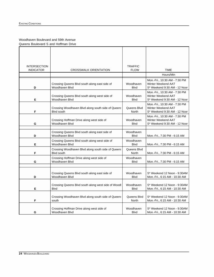
Woodhaven Boulevard and 59th AvenueQueens Boulevard S and Hoffman Drive
TIMEFLOWTRAFFIC
CROSSWALK ORIENTATIONINDICATORINTERSECTION
Hours/Min
S* Weekend 9:30 AM - 12 NoonWinter Weekend AAT Mon.-Fri., 10:30 AM - 7:30 PM
BlvdWoodhaven
Woodhaven Blvd Crossing Queens Blvd south along east side of
D
S* Weekend 9:30 AM - 12 NoonWinter Weekend AAT Mon.-Fri., 10:30 AM - 7:30 PM
BlvdWoodhaven
Woodhaven Blvd Crossing Queens Blvd south along west side of
E
S* Weekend 9:30 AM - 12 NoonWinter Weekend AAT Mon.-Fri., 10:30 AM - 7:30 PM
NorthQueens Blvd
Blvd southCrossing Woodhaven Blvd along south side of Queens
F
S* Weekend 9:30 AM - 12 NoonWinter Weekend AAT Mon.-Fri., 10:30 AM - 7:30 PM
BlvdWoodhaven
Woodhaven BlvdCrossing Hoffman Drive along west side of
G
Mon.-Fri., 7:30 PM - 6:15 AM BlvdWoodhaven
Woodhaven Blvd Crossing Queens Blvd south along east side of
D
Mon.-Fri., 7:30 PM - 6:15 AM BlvdWoodhaven
Woodhaven Blvd Crossing Queens Blvd south along west side of
E
Mon.-Fri., 7:30 PM - 6:15 AM NorthQueens Blvd
Blvd southCrossing Woodhaven Blvd along south side of Queens
F
Mon.-Fri., 7:30 PM - 6:15 AM BlvdWoodhaven
Woodhaven BlvdCrossing Hoffman Drive along west side of
G
Mon.-Fri., 6:15 AM - 10:30 AMS* Weekend 12 Noon - 9:30AM
BlvdWoodhaven
Woodhaven Blvd Crossing Queens Blvd south along east side of
D
Mon.-Fri., 6:15 AM - 10:30 AMS* Weekend 12 Noon - 9:30AM
BlvdWoodhaven
Blvd Crossing Queens Blvd south along west side of Woodh
E
Mon.-Fri., 6:15 AM - 10:30 AMS* Weekend 12 Noon - 9:30AM
NorthQueens Blvd
southCrossing Woodhaven Blvd along south side of Queens
F
Mon.-Fri., 6:15 AM - 10:30 AMS* Weekend 12 Noon - 9:30AM
BlvdWoodhaven
Woodhaven BlvdCrossing Hoffman Drive along west side of
G
25
SUBWAY-SIDEWALK INTERFACE PROJECT
WOODHAVEN BOULEVARD
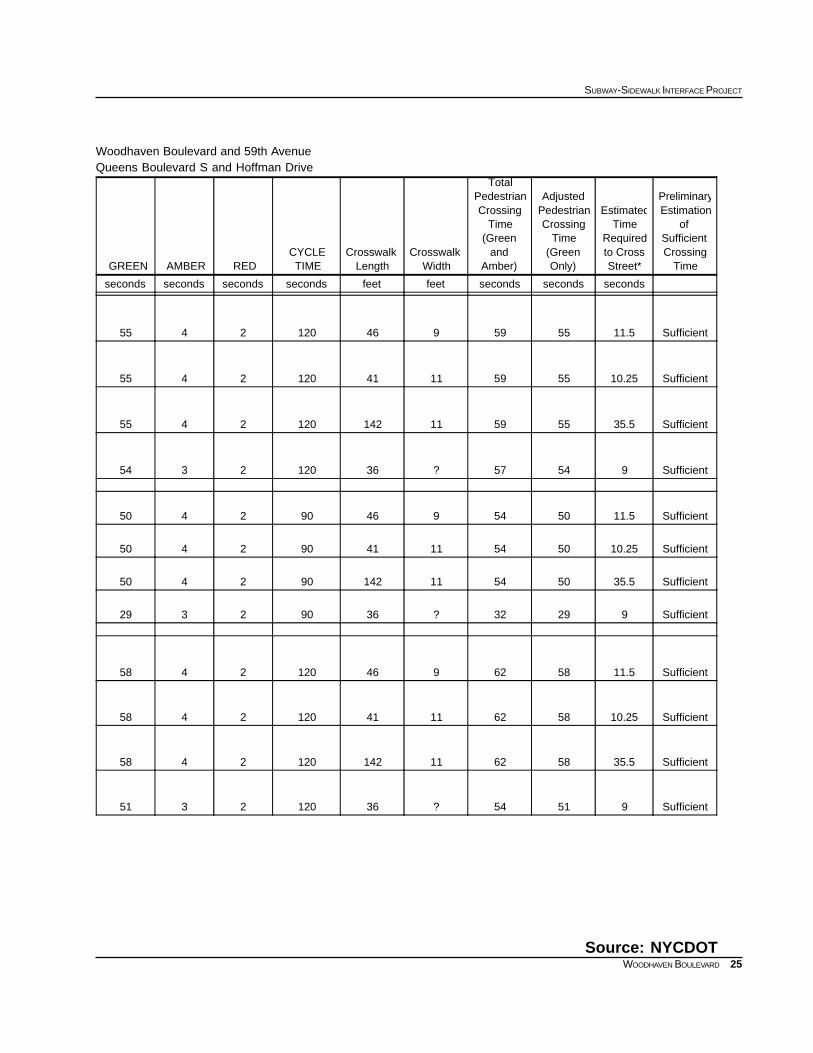
Woodhaven Boulevard and 59th AvenueQueens Boulevard S and Hoffman Drive
Source: NYCDOT
TimeCrossingSufficient
ofEstimationPreliminary
Street*to CrossRequired
TimeEstimated
Only)(GreenTime
CrossingPedestrianAdjusted
Amber)and
(GreenTime
CrossingPedestrian
Total
WidthCrosswalk
LengthCrosswalk
TIMECYCLE
REDAMBERGREEN
secondssecondssecondsfeetfeetsecondssecondssecondsseconds
Sufficient11.555599461202455
Sufficient10.25555911411202455
Sufficient35.55559111421202455
Sufficient95457?361202354
Sufficient11.55054946902450
Sufficient10.2550541141902450
Sufficient35.5505411142902450
Sufficient92932?36902329
Sufficient11.558629461202458
Sufficient10.25586211411202458
Sufficient35.55862111421202458
Sufficient95154?361202351
26
EXISTING CONDITIONS
WOODHAVEN BOULEVARD
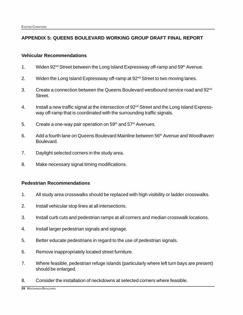
APPENDIX 5: QUEENS BOULEVARD WORKING GROUP DRAFT FINAL REPORT
Vehicular Recommendations
1. Widen 92nd Street between the Long Island Expressway off-ramp and 59th Avenue.
2. Widen the Long Island Expressway off-ramp at 92nd Street to two moving lanes.
3. Create a connection between the Queens Boulevard westbound service road and 92nd
Street.
4. Install a new traffic signal at the intersection of 92nd Street and the Long Island Express-way off-ramp that is coordinated with the surrounding traffic signals.
5. Create a one-way pair operation on 59th and 57th Avenues.
6. Add a fourth lane on Queens Boulevard Mainline between 56th Avenue and WoodhavenBoulevard.
7. Daylight selected corners in the study area.
8. Make necessary signal timing modifications.
Pedestrian Recommendations
1. All study area crosswalks should be replaced with high visibility or ladder crosswalks.
2. Install vehicular stop lines at all intersections.
3. Install curb cuts and pedestrian ramps at all corners and median crosswalk locations.
4. Install larger pedestrian signals and signage.
5. Better educate pedestrians in regard to the use of pedestrian signals.
6. Remove inappropriately located street furniture.
7. Where feasible, pedestrian refuge islands (particularly where left turn bays are present)should be enlarged.
8. Consider the installation of neckdowns at selected corners where feasible.
27
SUBWAY-SIDEWALK INTERFACE PROJECT
WOODHAVEN BOULEVARD
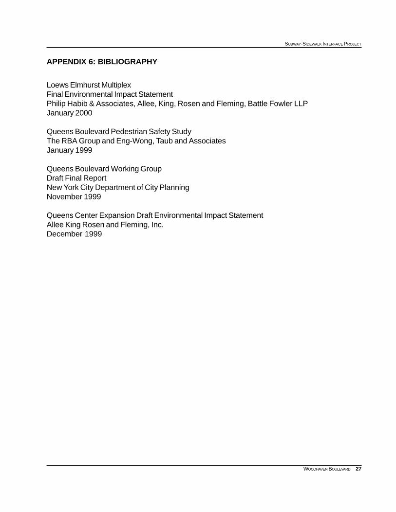
APPENDIX 6: BIBLIOGRAPHY
Loews Elmhurst MultiplexFinal Environmental Impact StatementPhilip Habib & Associates, Allee, King, Rosen and Fleming, Battle Fowler LLPJanuary 2000
Queens Boulevard Pedestrian Safety StudyThe RBA Group and Eng-Wong, Taub and AssociatesJanuary 1999
Queens Boulevard Working GroupDraft Final ReportNew York City Department of City PlanningNovember 1999
Queens Center Expansion Draft Environmental Impact StatementAllee King Rosen and Fleming, Inc.December 1999