1 USGEO Strategic Assessment Group Presented to GEO User Interface Committee Sept 23, 2008.
20
1 USGEO Strategic Assessment Group Presented to GEO User Interface Committee Sept 23, 2008
-
Upload
virginia-higgins -
Category
Documents
-
view
213 -
download
0
Transcript of 1 USGEO Strategic Assessment Group Presented to GEO User Interface Committee Sept 23, 2008.
1
USGEO Strategic Assessment Group
Presented toGEO User Interface Committee
Sept 23, 2008

2
USGEO
USGEOU. S. Group on Earth
Observations
Policy Group
Functional Groups
Architecture and Data
Management Group
Partnership, Outreach, and
Communication Group
Strategic Assessment
Group
Co-chairs: Phil DeCola (OSTP)Jim Tucker (NASA)
Peter Wilczynski (NOAA)
Membership:
DOE OMB NOAA NASA EPA DOD USDA
DOI DOT USAID USGS Smithsonian DOS NSF
InternationalWorkingGroup
New
3
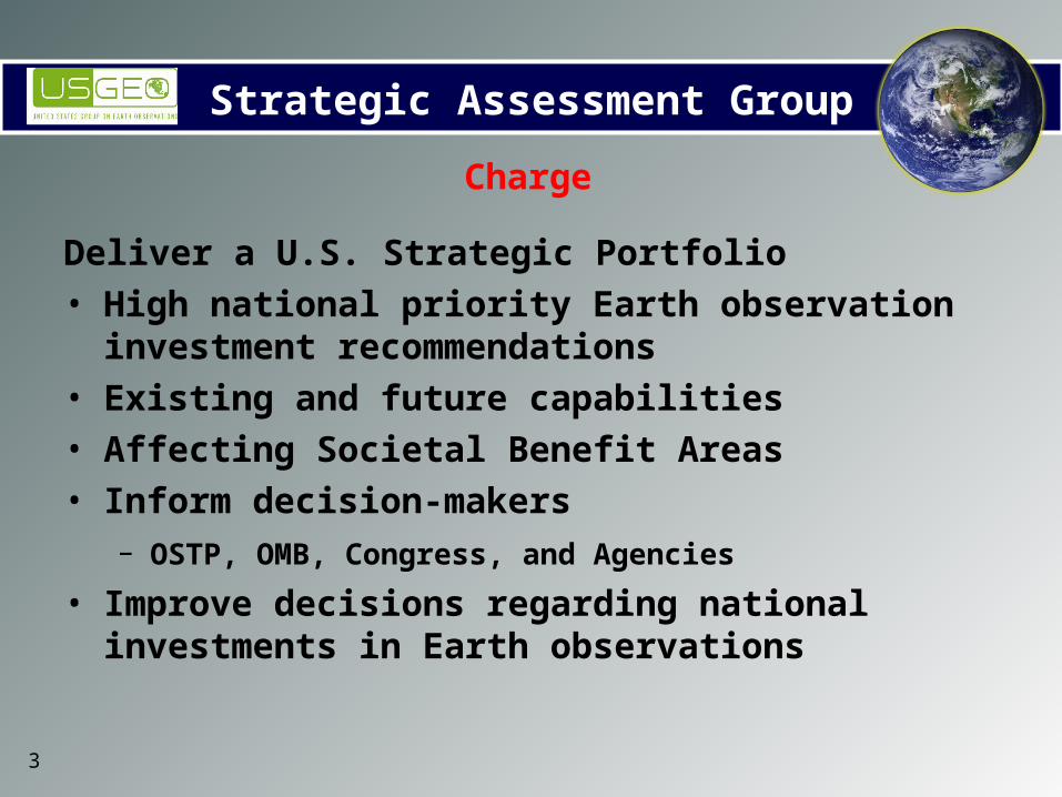
Strategic Assessment Group
Deliver a U.S. Strategic Portfolio • High national priority Earth observation investment
recommendations • Existing and future capabilities • Affecting Societal Benefit Areas • Inform decision-makers
– OSTP, OMB, Congress, and Agencies • Improve decisions regarding national investments in Earth
observations
Charge
4
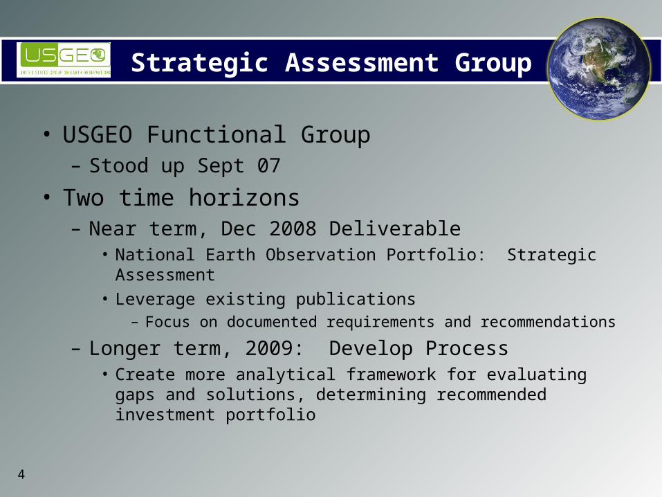
Strategic Assessment Group
• USGEO Functional Group– Stood up Sept 07
• Two time horizons– Near term, Dec 2008 Deliverable
• National Earth Observation Portfolio: Strategic Assessment• Leverage existing publications
– Focus on documented requirements and recommendations
– Longer term, 2009: Develop Process• Create more analytical framework for evaluating gaps and
solutions, determining recommended investment portfolio
5
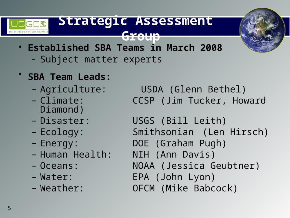
Strategic Assessment Group• Established SBA Teams in March 2008
– Subject matter experts• SBA Team Leads:
– Agriculture: USDA (Glenn Bethel)– Climate: CCSP (Jim Tucker, Howard
Diamond)– Disaster: USGS (Bill Leith) – Ecology: Smithsonian (Len Hirsch)– Energy: DOE (Graham Pugh)– Human Health: NIH (Ann Davis)– Oceans: NOAA (Jessica Geubtner) – Water: EPA (John Lyon)– Weather: OFCM (Mike Babcock)
6
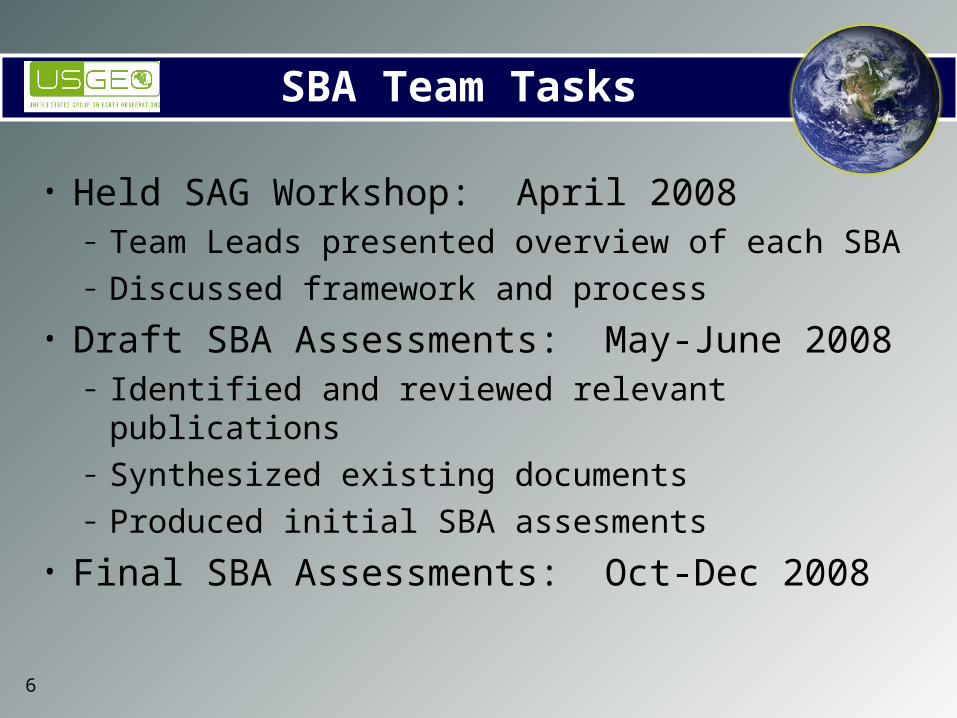
SBA Team Tasks
• Held SAG Workshop: April 2008– Team Leads presented overview of each SBA– Discussed framework and process
• Draft SBA Assessments: May-June 2008– Identified and reviewed relevant publications– Synthesized existing documents– Produced initial SBA assesments
• Final SBA Assessments: Oct-Dec 2008

7
USGEO SAG Tasks and Milestones
September October DecemberNovember
SAG Writing Team Completes Draft
Draft Circulated to USGEOComments Resolved External Coordination
Comments Resolved Publication Process
Draft Circulated to SAGComments Resolved
Assessment
Climate Assessment Document Completed (95%) Other 8 SBAs revise initial drafts to
conform to Climate Assessment formatCoordination of SBA Documents
Climate 2-Pager Drafted
2-Pagers for other SBAs DraftedCoordination of 2-Pagers
Supporting Documents
Sep 25 SAG Meeting

8
Agriculture EnergyEco/BiodivClimate Disaster Health Ocean Weather Water
SBA 2 Pagers to Support Assessment
SBA AssessmentDocuments (10-40 pages)(TRD Updates)
Existing Reports & Studies
Crosscutting nature of all observational parameters
Weather Disasters Climate Oceans AgricultureHuman Health
Ecology Water Energy
Atmospheric Ozone L L H L L H H L M
Cloud Properties H M H M M L L L H
Earth Radiation Budget H L H M H M M M H
Solar Irradiance L L H L L M M L L
Precipitation H H H M H H H H H
Assessment Document (10-20 pages)
Earth Observations Assessment
USGEO SAG Deliverables
Initial SBA Document Completed in May
Currently Working
Next Up – Climate 2-Pager
9
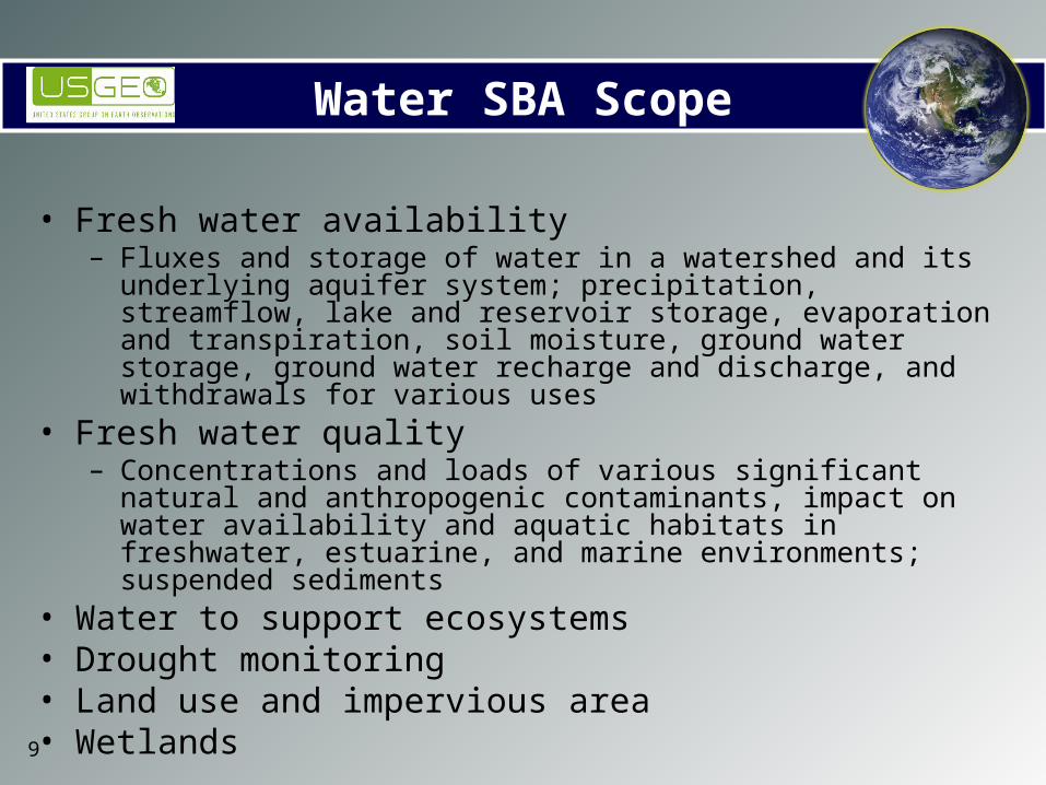
Water SBA Scope
• Fresh water availability – Fluxes and storage of water in a watershed and its underlying aquifer
system; precipitation, streamflow, lake and reservoir storage, evaporation and transpiration, soil moisture, ground water storage, ground water recharge and discharge, and withdrawals for various uses
• Fresh water quality– Concentrations and loads of various significant natural and anthropogenic
contaminants, impact on water availability and aquatic habitats in freshwater, estuarine, and marine environments; suspended sediments
• Water to support ecosystems• Drought monitoring• Land use and impervious area• Wetlands
10
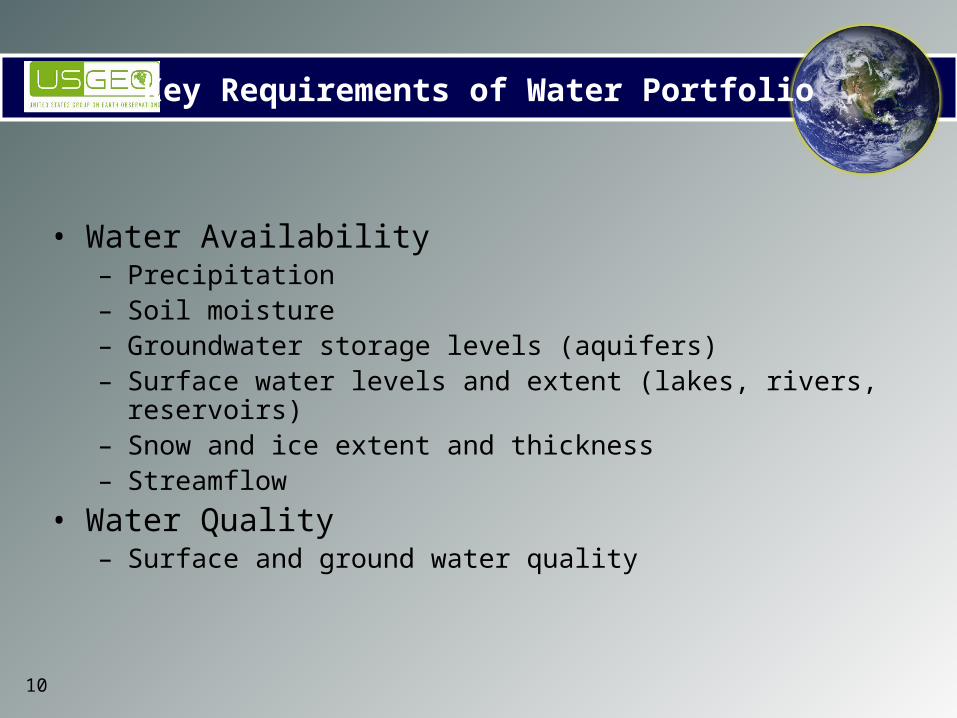
Key Requirements of Water Portfolio
• Water Availability– Precipitation– Soil moisture– Groundwater storage levels (aquifers)– Surface water levels and extent (lakes, rivers, reservoirs)– Snow and ice extent and thickness– Streamflow
• Water Quality– Surface and ground water quality
11
Key Requirements of Water Portfolio
• Precipitation– Importance to SBA: Central component of the global water cycle;
primary source of fresh water– Current status: Good national coverage with manual observing
stations and radar networks; precipitation gauges, surface-based radars, LEO passive microwave, LEO & GEO visible and IR cloud observations
– Near term gaps and challenges: More real-time ground-based data for quantification and calibration. Information on the vertical distribution of precipitation. Passive microwave observations need higher spatial and spectral resolution. Gaps in precipitation measurement over complex terrain.
– New capabilities needed: Better algorithms that blend observations from all sources
– Future capabilities: Exploit capability of space-borne radar (currently only a demonstrated capability)
– Crosswalk with other SBAs: Climate, Agriculture, Weather, Disaster

12
Key Requirements of Water Portfolio
• Soil Moisture– Importance to SBA: Regulates partitioning of incoming radiative energy into
sensible and latent heat fluxes and partitioning rain water between infiltration and runoff (and subsequently evaporation). Component of water cycle.
– Current status: Generally inadequate. Some local monitoring, but no coordinated network of in situ measurements. Heavy reliance on model-generated estimates.
– Near term gaps and challenges: No standardized procedures for selection of sensor type, measurement sites, sensor depth, sensor calibration and intercomparison, etc.
– New capabilities needed: More work to exploit soil moisture measurements derived from space. Need a supersite program to provide the comprehensive data sets needed for sensor evaluation and calibration, and provide basis for developing soil moisture algorithms for satellite measurements.
– Future capabilities: L-Band radar, radiometer– Crosswalk with other SBAs: Agriculture, Climate, Weather

13
Key Requirements of Water Portfolio
• Groundwater Storage Levels
– Importance to SBA: Major portion of world’s fresh water located underground. Key variable in water cycle, water availability, water quality.
– Current status: Data incomplete, unreliable or non-existent in many areas. Limited groundwater monitoring networks developed as pilot projects.
– Near term gaps and challenges: Data geographically limited. Interpretation of existing data is complex. Data not integrated. No reliable inventory exists.
– New capabilities needed: Most promising measurement concept is precise observation of time-dependent variations in the Earth gravity field using space-based gradiometer systems. Gravity field measurements are sensitive enough to detect minute gravitational changes in underground aquifers. (GRACE: Gravity Recovery And Climate Experiment). Need R&D to develop algorithms and error characteristics. Ground-truthing will be crucial.
– Future capabilities: Laser– Crosswalk with other SBAs: Climate, Solid Earth
14
Key Requirements of Water Portfolio
• Surface water levels and extent (lakes, rivers, reservoirs)
– Importance to SBA: Critical to water cycle, and for engineering designs for dams, reservoirs, river navigation systems, flood protection, irrigation scheduling, international water allocation agreements, ecosystem management and water management plans. Key variable in hydrological models.
– Current status: Surface storage in lakes, wetlands and river channels currently estimated. There is no real capacity to inventory these stores on a regional basis or estimate interseasonal and interannual variability.
– Near term gaps and challenges: Aging infrastructure. Lack of coherent national plan for data collection.
– New capabilities needed: Exploit hydrologic altimetry to provide surface water distribution from existing satellite systems.
– Future capabilities: Radar altimeter, nadir SAR interferometer, microwave radiometer, GPS receiver
– Crosswalk with other SBAs: Climate, Ecosystems, Health, Weather
15
Key Requirements of Water Portfolio
• Snow and ice extent and thickness– Importance to SBA: Fresh water storage variable in water cycle. Prediction of
spring and summer water supplies and flood potential.– Current status: Snow cover is estimated by satellite data (Landsat and
AVHRR). Passive microwave can also provide estimates for snow pack in some areas. Snow depth often measured manually.
– Near term gaps and challenges: Derived measurement accuracy varies greatly with snow properties, terrain, and cloud cover. Algorithm assumptions not always valid. Snow drifting affects estimation.
– New capabilities needed: Microwave satellites can provide enhanced observational capabilities for snow water equivalent. Need to ensure research capabilities continued for operational uses. More research on algorithm development.
– Future capabilities: Further development of multispectral sensors that will be able to provide freeze/thaw patterns under different vegetation conditions.
– Crosswalk with other SBAs: Climate, Agriculture, Weather

16
Key Requirements of Water Portfolio
• Streamflow
– Importance to SBA: Critical to water cycle, and for engineering designs for dams, reservoirs, river navigation systems, flood protection, irrigation scheduling, international water allocation agreements, ecosystem management and water management plans. Key variable in hydrological models.
– Current status: In situ only cost-effective and reliable option. Current networks are declining on a worldwide basis.
– Near term gaps and challenges: Data archive and exchange limited and fragmented; much data lacks quality control
– New capabilities needed: Investment in national network to monitor streamflow. Satellite altimetry shows promise in estimating river levels. Need extensive research on sensor optimization and algorithm development to determine feasibility
– Future capabilities: Current procedures are labor-intensive. Explore use of radar to automate streamflow monitoring.
– Crosswalk with other SBAs: Climate, Ecosystems, Energy
17
Key Requirements of Water Portfolio
• Surface and Ground Water Quality– Importance to SBA: Critical role in water management. – Current status: In situ measurements carried out for several decades time-
consuming and expensive. Many sampling programs have been scaled back due to budget constraints.
– Near term gaps and challenges: Fresh water contains a myriad of both dissolved and particulate matter that creates unique challenges for remote sensing. Episodic runoff events and algal blooms can occur in a short time period requiring frequent revisit periods. Remote sensing of water quality requires fine spatial resolution.
– New capabilities needed: Optimal freshwater satellite sensors will need high spectral, spatial, and temporal resolution capabilities. Precise, concurrent in situ measurements are a critical component to any remote sensing water quality investigation.
– Future capabilities: Hyperspectral imager, multispectral thermal sensor– Crosswalk with other SBAs: Health, Agriculture, Ecosystems

18
Water SBA Publications– USGEO Technical Reference Document: Protect and Monitor Water
Resources, Nov 8, 2004• http://usgeo.gov/documents4b93.html?s=review
– A Strategy for Federal Science and Technology to Support Water Availability and Quality in the United States, CENR, SWAQ, Sept 2007
• http://www.ostp.gov/cs/nstc/documents_reports– Science and Technology to Support Fresh Water Availability in the United States,
CENR, SWAQ, Nov 2004• http://www.ostp.gov/cs/nstc/documents_reports
– IGOS Cryosphere Theme Report, 2007• http://www.igospartners.org/cryosphere.htm
– Contributions of Land Remote Sensing for Decisions about Food Security and Human Health, Workshop Report, NRC
• http://books.nap.edu/openbook.php?record_id=11759&page=R1– Water for a Sustainable and Secure Future, National Council for Science and the
Environment 2004• http://www.ncseonline.org/2004conference/
– Assessing the TMDL Approach to Water Quality Management, NRC, 2001• http://www.nap.edu/openbook.php?isbn=0309075793
– Estimating Water Use in the United States, NRC, 2002• http://www.nap.edu/openbook.php?isbn=0309084830
19
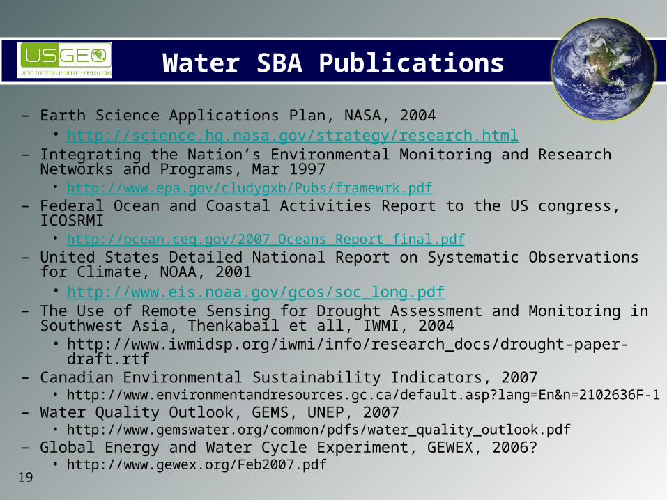
Water SBA Publications
– Earth Science Applications Plan, NASA, 2004• http://science.hq.nasa.gov/strategy/research.html
– Integrating the Nation’s Environmental Monitoring and Research Networks and Programs, Mar 1997
• http://www.epa.gov/cludygxb/Pubs/framewrk.pdf– Federal Ocean and Coastal Activities Report to the US congress, ICOSRMI
• http://ocean.ceq.gov/2007_Oceans_Report_final.pdf– United States Detailed National Report on Systematic Observations for Climate, NOAA,
2001• http://www.eis.noaa.gov/gcos/soc_long.pdf
– The Use of Remote Sensing for Drought Assessment and Monitoring in Southwest Asia, Thenkabail et all, IWMI, 2004
• http://www.iwmidsp.org/iwmi/info/research_docs/drought-paper-draft.rtf– Canadian Environmental Sustainability Indicators, 2007
• http://www.environmentandresources.gc.ca/default.asp?lang=En&n=2102636F-1– Water Quality Outlook, GEMS, UNEP, 2007
• http://www.gemswater.org/common/pdfs/water_quality_outlook.pdf– Global Energy and Water Cycle Experiment, GEWEX, 2006?
• http://www.gewex.org/Feb2007.pdf
20
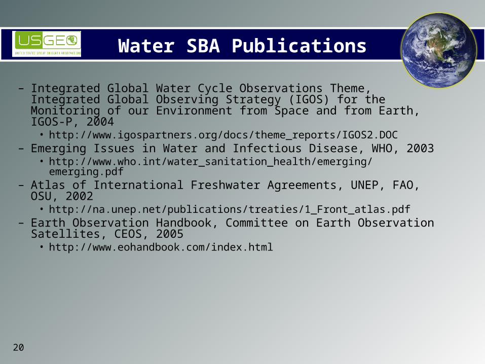
Water SBA Publications
– Integrated Global Water Cycle Observations Theme, Integrated Global Observing Strategy (IGOS) for the Monitoring of our Environment from Space and from Earth, IGOS-P, 2004
• http://www.igospartners.org/docs/theme_reports/IGOS2.DOC– Emerging Issues in Water and Infectious Disease, WHO, 2003
• http://www.who.int/water_sanitation_health/emerging/emerging.pdf– Atlas of International Freshwater Agreements, UNEP, FAO, OSU, 2002
• http://na.unep.net/publications/treaties/1_Front_atlas.pdf– Earth Observation Handbook, Committee on Earth Observation Satellites,
CEOS, 2005• http://www.eohandbook.com/index.html