1 The Nature Conservancy's Approach to Measuring Biodiversity
14
1 The Nature Conservancy’s Approach to Measuring Biodiversity Status and the Effectiveness of Conservation Strategies 1 Doria R. Gordon, Jeffrey D. Parrish, Daniel W. Salzer, Timothy H. Tear, and Beatriz Pace-Aldana The Nature Conservancy The Nature Conservancy is an international biodiversity conservation organization with the mission of preserving the plants, animals, and natural communities that represent the diversity of life on Earth by protecting the lands and waters they need to survive. To achieve this mission, The Conservancy implements a framework called Conservation by Design (The Nature Conservancy 2000), which aims to conserve portfolios of functional conservation areas within and across physiographically defined ecoregions (Bailey 1989, Olson et al. 2001). This framework involves a conservation planning effort that engages other conservation stakeholders and scientists who help to identify viable occurrences of species, communities, and ecosystems; design conservation areas and potential conservation projects that can conserve them; and establish priorities for conservation action (Groves et al 2002, Groves 2003). Once conservation areas (the “ecoregional portfolio;” see Table 1) are established for action, we design conservation strategies using a specified planning methodology, implement those strategies, and subsequently measure our progress toward conservation goals. The latter component necessitates that we monitor both changes in biodiversity and threat status over time and the effectiveness of our conservation strategies in effecting positive conservation change (Parrish et al. 2003, The Nature Conservancy 2003b,c). Conservation areas identified in ecoregional assessments are typically the focus of strategy development and monitoring efforts for The Nature Conservancy. Frequently, areas may be aggregated into a single planning effort because of their geographic proximity and ecological similarities. Such is the case in the Lake Wales Ridge Landscape Conservation Project in Florida. This project describes a roughly 600,000 ac landscape with specific soil and hydrological characteristics that contains 37 conservation areas that have been identified in the ecoregional portfolio (Fig. 1). Conversely, in another region, multiple sites may each require individual plans because of substantial differences among sites in ecological conditions or conservation targets (Table 1) and their threats. The Lake Wales Ridge xeric upland sites are an archipelago of inland sand ridges and dune systems (Fig. 1), deposited over a million years ago, and remaining as refuges during high sea levels of the Pleistocene and earlier (Weekly and Menges 2003). While the elevation difference is not striking, sites over 30 m higher than the surrounding lands often remained exposed. Soils are excessively draining sands, resulting in drought-adaptation in many of the species despite the 50-55 inches of annual rainfall. Evergreen hardwood shrubs dominate this community, sometimes with a sparse overstory of pines. The groundcover includes exposed soil, and a diversity of patchy herbaceous species. Structure of the habitat is fire-maintained, as thunderstorms are prevalent across peninsular Florida during the summer. As sea levels fluctuated, these habitats became more or less connected with surrounding habitat, repeatedly joining and isolating populations of plants and animals. As a result, these communities now harbor the highest number of endemic plant species of any community in Florida. Unfortunately, conversion of scrub for agriculture and development has reduced this habitat by over 85% (Weekly and Menges 2003). As a result 22 plants, 3 reptiles, and one bird species are now listed as Federally threatened or endangered. Not surprisingly, the Ridge has long been identified as a critical landscape for conservation in Florida by The Nature Conservancy. The design of highly effective conservation strategies (Table 1), and the measurement of the change in biodiversity status as a result of those actions requires a rigorous assessment of both the ecological integrity 1 This example of The Nature Conservancy’s conservation project planning approach is in press in: Principles of Conservation Biology, 3rd Edition. 2005. Groom, MJ., G.K. Meffe, and R.C. Carroll, eds. Sinauer Press: Sunderland, MA. Please use this citation when citing this document.
Transcript of 1 The Nature Conservancy's Approach to Measuring Biodiversity
1
The Nature Conservancy’s Approach to Measuring Biodiversity Status and the Effectiveness of Conservation Strategies1
Doria R. Gordon, Jeffrey D. Parrish, Daniel W. Salzer, Timothy H. Tear, and Beatriz Pace-Aldana
The Nature Conservancy
The Nature Conservancy is an international biodiversity conservation organization with the mission of preserving the plants, animals, and natural communities that represent the diversity of life on Earth by protecting the lands and waters they need to survive. To achieve this mission, The Conservancy implements a framework called Conservation by Design (The Nature Conservancy 2000), which aims to conserve portfolios of functional conservation areas within and across physiographically defined ecoregions (Bailey 1989, Olson et al. 2001). This framework involves a conservation planning effort that engages other conservation stakeholders and scientists who help to identify viable occurrences of species, communities, and ecosystems; design conservation areas and potential conservation projects that can conserve them; and establish priorities for conservation action (Groves et al 2002, Groves 2003). Once conservation areas (the “ecoregional portfolio;” see Table 1) are established for action, we design conservation strategies using a specified planning methodology, implement those strategies, and subsequently measure our progress toward conservation goals. The latter component necessitates that we monitor both changes in biodiversity and threat status over time and the effectiveness of our conservation strategies in effecting positive conservation change (Parrish et al. 2003, The Nature Conservancy 2003b,c). Conservation areas identified in ecoregional assessments are typically the focus of strategy development and monitoring efforts for The Nature Conservancy. Frequently, areas may be aggregated into a single planning effort because of their geographic proximity and ecological similarities. Such is the case in the Lake Wales Ridge Landscape Conservation Project in Florida. This project describes a roughly 600,000 ac landscape with specific soil and hydrological characteristics that contains 37 conservation areas that have been identified in the ecoregional portfolio (Fig. 1). Conversely, in another region, multiple sites may each require individual plans because of substantial differences among sites in ecological conditions or conservation targets (Table 1) and their threats.
The Lake Wales Ridge xeric upland sites are an archipelago of inland sand ridges and dune systems (Fig. 1), deposited over a million years ago, and remaining as refuges during high sea levels of the Pleistocene and earlier (Weekly and Menges 2003). While the elevation difference is not striking, sites over 30 m higher than the surrounding lands often remained exposed. Soils are excessively draining sands, resulting in drought-adaptation in many of the species despite the 50-55 inches of annual rainfall. Evergreen hardwood shrubs dominate this community, sometimes with a sparse overstory of pines. The groundcover includes exposed soil, and a diversity of patchy herbaceous species. Structure of the habitat is fire-maintained, as thunderstorms are prevalent across peninsular Florida during the summer. As sea levels fluctuated, these habitats became more or less connected with surrounding habitat, repeatedly joining and isolating populations of plants and animals. As a result, these communities now harbor the highest number of endemic plant species of any community in Florida. Unfortunately, conversion of scrub for agriculture and development has reduced this habitat by over 85% (Weekly and Menges 2003). As a result 22 plants, 3 reptiles, and one bird species are now listed as Federally threatened or endangered. Not surprisingly, the Ridge has long been identified as a critical landscape for conservation in Florida by The Nature Conservancy. The design of highly effective conservation strategies (Table 1), and the measurement of the change in biodiversity status as a result of those actions requires a rigorous assessment of both the ecological integrity 1 This example of The Nature Conservancy’s conservation project planning approach is in press in: Principles of Conservation Biology, 3rd Edition. 2005. Groom, MJ., G.K. Meffe, and R.C. Carroll, eds. Sinauer Press: Sunderland, MA. Please use this citation when citing this document.

2
and threats. Such an assessment ensures that conservation actions are prioritized according to the greatest challenges facing the biodiversity and that their effectiveness can be tracked over time. Although The Nature Conservancy has had methods for conducting such assessments for many years (Baumgartner 2001), we needed to develop a more scientifically, temporally, and spatially consistent method for measuring ecological integrity and the extent and severity of threats to biodiversity of concern. Table 1. Definitions of terms used by The Nature Conservancy to describe components of this conservation planning process. Term Definition Ecoregional Portfolio
The suite of areas of biodiversity significance identified in an ecoregional assessment that can conserve representative occurrences of biological diversity targeted to meet conservation goals.
Conservation Area
An area identified in the portfolio and defined by features such as vegetation, geology, elevation, landform, ownership, or other features, which is the focus of strategies designed to conserve a suite of conservation targets. Conservation areas are designed to maintain the targets and their supporting ecological processes within their natural ranges of variability. Conservation areas range along a continuum of complexity and scale, from landscapes that seek to conserve a large number of conservation targets and multiple scales, to small sites that seek to conserve a limited number of targets.
Conservation Targets
Populations of imperiled species, natural communities, and ecosystems identified through the conservation planning process as priorities for maintenance of long-term persistence within a defined area.
Conservation Strategy
A suite of actions designed to achieve a specific objective or outcome that abates a threat or enhances the ecological integrity of a conservation target.
Ecological Integrity
Maintenance of viability for a species target, or maintenance of processes, composition, structure, and function within the natural range of variation for a natural community or system-level target.
Key Ecological Attributes
The most critical components of biological composition, structure, interactions and processes, environmental regimes, and landscape configuration that sustain a target’s ecological integrity.
Attribute Categories
Size: the population size needed for viability or area needed to support the natural processes maintaining a community or ecological system. Condition: the demography, structure, species composition, and vigor of the conservation target Landscape Context: distribution, connectedness, proximity to other habitats, and land use of adjacent areas necessary to maintain viable populations, or sustain natural community or system-level conservation targets.
Indicators Measurable entities that are used to assess the status and trend of a key ecological attribute or other factor. A good indicator meets the criteria of being measurable, precise, consistent, relevant, and sensitive (see text for examples).
In 2002, an effort was initiated within The Nature Conservancy to improve methods for assessing the conservation status of focal biodiversity: the imperiled species, functional communities, and natural systems (collectively the “conservation targets” sensu Noss 1996) across the ecoregion. We also wanted to better understand whether conservation strategies were effectively abating threats to those conservation targets. The movement toward measurement of ecological integrity (Table 1) and threat status of

3
Figure 1. The Lake Wales Ridge Conservation Area, Florida. The entire Ridge is highlighted in yellow, while the portfolio of sites included in the project are in two shades of green: dark green - current conservation ownership in dark green, and light green - Florida Forever projects proposed for purchase by the State of Florida in 2004. Data on managed area and Florida Forever project boundaries provided by the Florida Natural Areas Inventory.
HighlandsCounty
PolkCounty
LakeCounty
OsceolaCounty
OrangeCounty
Archbold Biological StationGIS Laboratory
R.L. Pickert - 19 April 2004
Lake Wales Ridge
0 10 20
Kilometers
¬
Lake Wales RidgeProtected Areas Network
2004Lake Wales Ridge
Florida Forever Project Boundaries
2004Federal, State, Local or
Private conservation ownership

4
biodiversity is an attempt to more accurately assess conservation outcomes. This approach more directly assesses progress toward the Conservancy’s mission than do the indirect measures of number of acres in conservation status and numbers of dollars raised for conservation action traditionally tracked by the organization (Salafsky et al. 2002, Christensen 2003). Through scientific consultation and field testing, The Nature Conservancy developed an improved process that explicitly addresses the status of biodiversity (The Nature Conservancy 2003c). The goal of this planning process is the development of a robust, practical conservation plan that identifies efficient strategies designed to meet explicit conservation objectives, and whose outcome can be directly measured in terms of the species, communities, and natural systems identified for conservation2. The steps include:
1. Identifying the planning area of concern and a limited number of focal conservation targets3 (Table 1).
2. Identifying and assessing the status of key ecological attributes (Table 1) for each focal conservation target that drive its composition, structure, and ecological function, and can be used to help assess target ecological integrity4 (Parrish et al. 2003).
3. Identifying and rating the status of measurable indicators (Table 1) of the target’s key ecological attributes and describing their natural range of variation.
4. Identifying and prioritizing the direct threats to the focal conservation targets and identifying which attributes of integrity are impacted.
5. Linking targets, threats, and other factors in a chain-of-causation and/or conceptual model to assist in conceptualizing and prioritizing actions.
6. Developing measurable, outcome-oriented objectives for improving the ecological integrity of a conservation target or abating critical threats to that target.
7. Developing strategies, with timelines, resources needed, and action items for accomplishing the objectives.
8. Developing and implementing a monitoring program for the identified indicators to measure changes in integrity and threat status and whether proposed objectives were achieved.
9. Modifying strategies and objectives as appropriate to ensure that targets progress toward improved or maintained ecological integrity.
10. Sharing information and lessons learned across the broader conservation community.
These steps are not conducted linearly, but require iterative efforts until an initial plan is developed. Further, this process is intended to involve people from outside of the Conservancy, both to incorporate all data and expertise available, and to develop partnerships and commitment to plan implementation from many organizations and individuals.
The first step of the approach is the identification of focal conservation targets that represent the terrestrial, freshwater, and marine (as applicable) biodiversity across a range of geographic scales in the conservation area or project (Poiani et al. 2000) (e.g., Fig. 2). Given our limited knowledge of the ecology of most elements of biodiversity, it is very difficult to identify a small number of focal conservation targets that reflect the status of all the species present. Those species that play keystone roles, require a range of habitats over a large area, or respond rapidly to environmental changes that will eventually impact many other species may be appropriate choices. However, the “coarse-filter” approach (Noss and Cooperrider 1994) necessarily suggests that ecological communities or larger systems that support numerous species should be considered first and then supplemented with species or communities likely to require more focused attention for conservation (Parrish et al. 2003).
2 Greater detail about this planning approach is in The Nature Conservancy 2003c and Parrish et al. 2003. 3 Focal conservation targets are a small subset of the biodiversity that are selected to comprehensively represent the full range of biodiversity that occur within a given area. 4 A conservation target is said to have ecological integrity when its dominant ecological components (e.g., composition, structure, function, ecological processes, biotic interactions) are within their natural ranges of variation such that it can withstand or recover from most natural or anthropogenic disturbances (Parrish et al 2003).

5
Figure 2. Focal Conservation Targets for the Lake Wales Ridge Conservation Area.
Seven targets for the Ridge have been chosen to represent the ecosystem and species for conservation planning efforts (Fig. 2):
1) xeric upland matrix and embedded wetlands -- The matrix target consists of the xeric upland “islands,” their associated seasonal ponds, and the surrounding lowlands, all of which have experience substantial losses in area (Weekly and Menges 2003). The xeric uplands consist of three different community types, varying in soil type, composition, structure, fire frequency and intensity, and to a lesser degree, elevation: sandhills, scrub, and scrubby flatwoods (Myers 1990). Lowlands include seasonal ponds, wet and mesic flatwoods and prairies, seepage slopes, and several types of forested wetlands. These areas require fire at the high frequency of the sandhills, every 2-5 years (Florida Natural Areas Inventory and Department of Natural Resources 1990). Shrub encroachment, as in the uplands, results from absence of fire as well as lowering of water tables.
2) Florida scrub-jays -- The Florida scrub-jay is Federally listed as Threatened, and the state population has declined by almost 50% over the past 100 years (Fitzpatrick et al. 1991). Scrub-jays inhabit rosemary-oak scrub and scrubby flatwoods (types of the xeric upland matrix) where fire has limited pine invasion and shrub heights. This species was made a target separate from the xeric upland matrix because of its endangerment and resulting urgency for fire management to create suitable habitat.
3) rare upland plants of concern (Crotalaria avonensis, Dicerandra christmanii, Dicerandra frutescens, Conradina brevifolia, and Polygala lewtonii) -- These rare upland plants are of particular concern because of their restricted ranges, few protected sites, and fire suppression of much of the remaining habitat.
4) sand-dwelling organisms (sand skink [Neoseps reynoldsi], blue-tailed mole skink [Eumeces egregius lividus], soil crusts, and numerous invertebrates) -- Like some of the rare plants, the sand-dwelling organisms require open sand gaps that are lost with fire suppression. These organisms were separated from the xeric upland matrix because the mechanical management methods some land managers are using instead of fire have unknown impacts on fossorial or soil surface organisms and because in long unburned areas where woody shrubs have become dominant, fire has resulted in only short-term increases in open sand, which soon disappear as shrubs resprout.

6
5) cutthroat grass (Panicum abscissum) communities -- At least 80% of this central Florida endemic have been lost to agriculture and other development (Bacchus 1991). In remaining natural habitat, lowered water tables have resulted in a decrease of potential habitat for cutthroat grass. Where cutthroat grass mains, fire exclusion has led to the displacement of herbaceous cover by shrubs. Thus, this species requires maintenance of both the fire and local hydrologic regimes for persistence.
6) Florida ziziphus (Ziziphus celata) -- Only five populations of this Endangered shrub remain. All but one of these areas are on unprotected private lands. Genetic and demographic studies reveal extremely low genetic variability and high reproductive incompatibility within the populations (Weekley et al. 2002). Long-term viability of this species will depend on creation of new, sexually compatible populations on conservation areas.
7) blackwater/seepage streams -- Six high-quality seepage/blackwater stream systems remain on the Lake Wales Ridge. The numerous other streams have been severely degraded by lowered water tables, low water quality, and non-native invasive species. The six stream systems targeted are at least partially within conservation sites, but increasing development and associated water demand around those sites threaten these systems.
Identifying a minimum number of key ecological attributes that are necessary to maintain the ecological integrity or long-term viability of each focal conservation target is the next challenge. On the Lake Wales Ridge, for example, the conservation goals require not only that the seven targeted upland plants, animals, and natural communities are present, but that they will be healthy over at least the next 100 years. Because each attribute that defines “health” for each target will involve one or more indicators, and our capacity to monitor indicators in any given conservation project is typically low, keeping the numbers of attributes low is critical. One attribute for each of three categories of ecological attributes that influence biodiversity: size, condition, and landscape context (Table 1), may be sufficient for estimating the status of the conservation target. Often ecological models are useful for identifying the most critical attributes for status and integrity assessment. On the Lake Wales Ridge Conservation Area, the interaction between fire frequency and soil drainage may determine the plant community that develops on these xeric sites (Fig. 3). Key attributes for the xeric upland matrix and embedded wetlands target include fire regime, vegetation structure, land use in a ¼ mile buffer around each conservation site (which influences the ability to conduct prescribed fires), contiguity between wetlands and adjacent uplands, and contiguity between wetlands under 500 meters apart. Key attributes for the federally threatened Florida scrub-jay (Aphelocoma coerulescens) include population size, recruitment, vegetation structure, and distance between protected scrub habitat patches (The Nature Conservancy 2002). Figure 3. Partial ecological model identifying fire frequency and hydrology as key ecological attributes of six community types within the xeric upland matrix focal conservation target at the Lake Wales Ridge Conservation Area (modified from Menges 1993).

7
Key ecological attributes may be impossible to measure directly, requiring identification of one or more indicators that can be feasibly and effectively measured. Again, only a limited number of indicators should be selected. And if another organization or agency is already monitoring several relevant variables, indicators would ideally be selected from that group (e.g., water flows and turbidity, soil or water chemistry, breeding pairs). Indicators need to be measurable, precise, sensitive, relevant, and cost-effective (Noss 1990, Margoluis and Salafsky 1998). Ideally, they will provide early warning of changes in the attribute that would impact target viability. Indicators are likely to be refined over time as our knowledge of the target and its measurement improve. Ultimately our goal at conservation areas is to conserve the focal conservation targets. A target can be considered “conserved” when each of its key ecological attributes are within their natural or acceptable range of variation (Parrish et al. 2003). For example, the different scrub systems that comprise a component of the upland xeric matrix on the Lake Wales Ridge vary in the proportion of naturally occurring bare soil cover. Those openings in the shrubby canopy are critical for Florida scrub-jay acorn burial (DeGrange et al. 1989), recruitment of herbaceous species (Young and Menges 1999), and habitat for a variety of invertebrates (Deyrup and Eisner 1993). Prior to the shifts in management and composition caused by recent human activities, the natural bare soil cover depended only on the soils, vegetation composition, local disturbance (e.g., tree falls, animal burrows), and fire history. Literature review and expert consultation suggested that bare soil might naturally range between 16 and 50% cover (The Nature Conservancy 2002). Percent cover above or below that range is considered outside of the natural range of variation for bare soil, requiring restoration before the structure will support viable populations of its constituent species. The concept of natural, or acceptable ranges of variation underpins The Conservancy’s conservation area planning methodology and rating of ecological integrity, which uses quantitative, continuous data to define categorical ratings of status as “very good”, “good”, “fair”, and “poor” (Table 2). The status of a key ecological attribute is considered good or better if their indicators tell us that the attribute is within its natural (or acceptable) range of variation, and fair or poor if the attributes fall outside that minimum desired range. This ecological concept grounds the rating of ecological integrity status in the ecological principle of ranges of variation (Landres et al. 1999), providing greater rigor in our measurement, and ensures consistency in interpretation of rating scores across conservation areas and within a conservation areas over time (Parrish et al. 2003). Because we generally have insufficient data to develop these ranges, indicator ratings are considered hypotheses that will also be refined. However, the quantitative specifications allow evaluation of status of the indicator over time. If the ranges defining the rating are modified as our understanding increases, earlier data may be re-evaluated. Table 3 shows the ratings for some indicators of key attributes for the xeric upland matrix and Florida scrub-jay focal targets across the Lake Wales Ridge landscape. The ratings were developed from published literature (e.g., Fitzpatrick et al. 1991, Young and Menges 1999) and expert input. Once the ratings have been developed, both current condition (shaded in Table 3) and desired future condition (italics in Table 3) can be determined. The latter define the quantitative viability objectives for which strategies and actions are developed. For example, an objective for the xeric upland matrix target is that by 2013, over 80% of the area remaining in this community type (including the embedded wetlands) has a fire return interval of between 5 and 15 years (first row of Table 3). The Nature Conservancy specifies that objectives identify quantitative, clear, desired conditions and timeframes that are feasible, appropriate, and based on the best scientific information available (The Nature Conservancy 2003b). These objectives then form the basis for strategic actions designed to move the indicator and target condition from the current status to the desired status. Where the indicator rating is already good or very good, an objective is only necessary if the rating is likely to decrease without conservation action. Strategies are developed to accomplish the objective within the specified timeframe and therefore need to focus on maximizing effectiveness and feasibility. The actions necessary to accomplish the strategies need similar specification. For the Florida scrub-jay, a Lake Wales Ridge project focal target, recruitment within sites is considered a critical attribute of viability. The indicator involved is the mean number of juveniles per family per site in
8
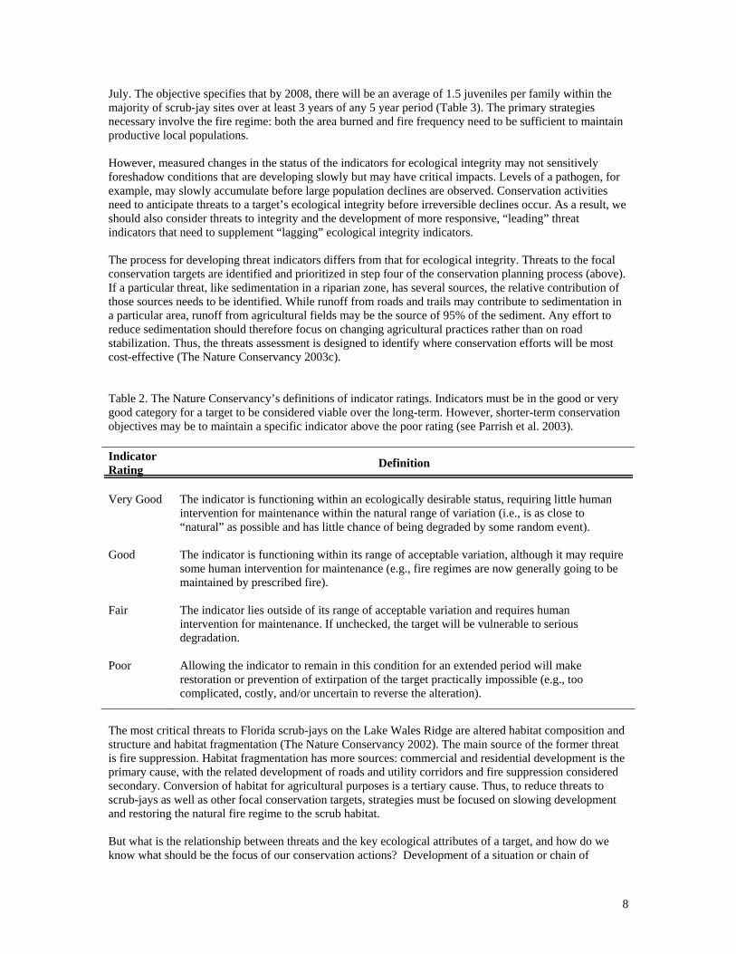
July. The objective specifies that by 2008, there will be an average of 1.5 juveniles per family within the majority of scrub-jay sites over at least 3 years of any 5 year period (Table 3). The primary strategies necessary involve the fire regime: both the area burned and fire frequency need to be sufficient to maintain productive local populations. However, measured changes in the status of the indicators for ecological integrity may not sensitively foreshadow conditions that are developing slowly but may have critical impacts. Levels of a pathogen, for example, may slowly accumulate before large population declines are observed. Conservation activities need to anticipate threats to a target’s ecological integrity before irreversible declines occur. As a result, we should also consider threats to integrity and the development of more responsive, “leading” threat indicators that need to supplement “lagging” ecological integrity indicators. The process for developing threat indicators differs from that for ecological integrity. Threats to the focal conservation targets are identified and prioritized in step four of the conservation planning process (above). If a particular threat, like sedimentation in a riparian zone, has several sources, the relative contribution of those sources needs to be identified. While runoff from roads and trails may contribute to sedimentation in a particular area, runoff from agricultural fields may be the source of 95% of the sediment. Any effort to reduce sedimentation should therefore focus on changing agricultural practices rather than on road stabilization. Thus, the threats assessment is designed to identify where conservation efforts will be most cost-effective (The Nature Conservancy 2003c). Table 2. The Nature Conservancy’s definitions of indicator ratings. Indicators must be in the good or very good category for a target to be considered viable over the long-term. However, shorter-term conservation objectives may be to maintain a specific indicator above the poor rating (see Parrish et al. 2003). Indicator Rating Definition
Very Good The indicator is functioning within an ecologically desirable status, requiring little human
intervention for maintenance within the natural range of variation (i.e., is as close to “natural” as possible and has little chance of being degraded by some random event).
Good The indicator is functioning within its range of acceptable variation, although it may require some human intervention for maintenance (e.g., fire regimes are now generally going to be maintained by prescribed fire).
Fair The indicator lies outside of its range of acceptable variation and requires human intervention for maintenance. If unchecked, the target will be vulnerable to serious degradation.
Poor Allowing the indicator to remain in this condition for an extended period will make restoration or prevention of extirpation of the target practically impossible (e.g., too complicated, costly, and/or uncertain to reverse the alteration).
The most critical threats to Florida scrub-jays on the Lake Wales Ridge are altered habitat composition and structure and habitat fragmentation (The Nature Conservancy 2002). The main source of the former threat is fire suppression. Habitat fragmentation has more sources: commercial and residential development is the primary cause, with the related development of roads and utility corridors and fire suppression considered secondary. Conversion of habitat for agricultural purposes is a tertiary cause. Thus, to reduce threats to scrub-jays as well as other focal conservation targets, strategies must be focused on slowing development and restoring the natural fire regime to the scrub habitat. But what is the relationship between threats and the key ecological attributes of a target, and how do we know what should be the focus of our conservation actions? Development of a situation or chain of

9
causation diagram can help to link the most critical threats and other factors affecting the integrity of focal conservation targets to their sources (Margoluis and Salafsky 1998). These diagrams, which articulate the direct and indirect influences on integrity, help identify where conservation action may best be applied for long-term, effective conservation results. When all the focal conservation targets of the Lake Wales Ridge are combined, the primary threats are similar to those discussed for Florida scrub-jays alone: alteration of natural fire regimes, habitat destruction or conversion, habitat fragmentation, and habitat disturbance (The Nature Conservancy 2002). The primary sources of these threats are commercial and residential development, fire suppression, development of roads or utilities, and excessive withdrawal of surface waters. Clearly these threats and sources are not independent of each other. Developments require roads, utilities, and water. As human density and structures increasingly fragment the landscape, application of prescribed fire becomes more difficult (Fig. 4). Where conservation areas have high edge-to-interior ratios, smoke management becomes an increasing safety and health issue, liability issues increase, influencing the will and ability to apply fire, and public opinion becomes all-important. Clearly defining the links will again clarify where taking action might be most effective. While the ultimate objective is to ensure prescribed burning to mimic the natural fire regime, more proximate objectives and strategies may focus on growth management and water use issues and public education about the dependence of these natural systems on fire and hydrology. This assessment leads to development of quantitative threat abatement objectives addressing specific factors in the situation diagram. Once both viability objectives associated with specific indicators and threat abatement objectives have been defined, strategies are then developed. Selection of the most effective and efficient strategies is based on evaluation of the benefits, feasibility, and cost of each (The Nature Conservancy 2003b). This assessment is designed to identify those strategies that produce high benefits at reasonable cost, but acknowledges that threats to conservation targets may require that expensive strategies be included. Once the primary strategies are determined, the necessary actions associated with each strategy, time frame and responsibility may be identified. For the fire-return-interval objective stated above (by 2013, over 80% of the xeric upland area remaining has a fire return interval of between 5 and 15 years), both reflecting an indicator of viability and designed to abate the threat of altered fire regimes, the Lake Wales Ridge Landscape planning team identified four strategies with associated actions to be initiated in 2004 (The Nature Conservancy 2002):
(1) Expand the interagency “Fire Strike Team” developed by the Conservancy to increase the acreage burned on property of all the agencies;
(2) Explore establishing Safe Harbor5 agreements to allow management of multi-parcel sites; (3) Create a comprehensive fire awareness program in properties adjacent to conservation
areas; and (4) Assist the Polk County Environmental Lands Program with fire training, planning, and
conducting prescribed fire.
The first strategy requires that Conservancy staff secure sufficient funding to make the Fire Strike Team operational all year rather than for the five months per year the Team had been active. The identified need is to burn an average of 2,000 ac / year. The second strategy requires exploration of interest in the Safe 5 Safe Harbor is a Federal Program of voluntary agreements with non-Federal landowners to carry out specified conservation measures to benefit a listed species. The Conservancy is exploring this as an option to allow fire management of conservation sites where several private inholdings still exist. The goal is for the conservation area land managers to be permitted to burn the inholdings with the permission of the landowners and be covered under the Endangered Species Act.

10
Table 3. Partial viability assessment for the Xeric Upland Matrix and Embedded Wetlands and Florida Scrub-jay targets modified from the Lake Wales Ridge Conservation Area Plan (The Nature Conservancy 2003a, modified from The Nature Conservancy 2002).
Conservation Target
Key Ecological Attribute* Indicator* Indicator Ratings*
Categorical Current state: shaded; Italics = Desired Rating
Date of Current Rating*
Date of Desired Rating*
Category
Poor Fair Good Very Good
Xeric Upland Matrix
Landscape
Context
fire regime fire frequency < 60% of area burned
within 5-15 yrs 60-80% of area burned
within 5-15 yrs >80% of area burned within
5-15 yrs n/a Feb - 03 Dec - 13
Xeric Upland Matrix Condition
community structure - sandhill
% cover of shrub midstory
(1-3 m) > 75% 51-75% 26-50% 25% or less. Feb - 03 Dec - 15
Xeric Upland Matrix Condition community
structure - scrub
% oak composition of shrubs within
scrub-jay habitat
< 20% 20-35% 36-50%
> 50%
Feb - 03. Dec - 15
Xeric Upland Matrix Condition
community structure - sandhill
% cover native herbaceous layer 0-4% cover 5-10% cover 11-30% cover > 30% cover Feb - 03 Dec - 15
Xeric Upland Matrix Condition community
structure - scrub % cover bare
soil 0-9% or > 80% 10-15% or 51-80% 16-25% 26-50% Feb - 03 Dec - 15
Xeric Upland Matrix Condition community
structure - scrub mean shrub
height < 0.5 m or > 4 m 3-4 m or 0.5-1 m 2-3 m 1-2 m Feb - 03 Dec - 15
Xeric Upland Matrix Size area area in protected
status
All natural uplands as of 2003 that are at least 1000 ac are protected
All natural uplands as of 2003 that are at least 500
ac are protected
All natural uplands as of 2003 that are at least 200 ac
are protected
All natural uplands as of
2003 that are at least 100 ac are protected
Feb - 03 Dec - 08
FL scrub-jay Landscape Context connectivity
distance between scrub
habitat (>1 km forest)
12 km or more > 4 and < 12 km 2-4 km < 2 km Feb - 03 Dec - 08
FL scrub-jay Condition recruitment mean # juveniles / breeding group per site in July
<0.5 within majority of sites within a t least 3 yrs
of any 5 yr period
0.5-1 within majority of sites within a t least 3 yrs
of any 5 yr period
1-1.5 within majority of sites within a t least 3 yrs of
any 5 yr period
>1.5 within majority of sites over at least 3 yrs of any 5
yr period Jul - 02 Dec - 13
FL scrub-jay Size population size # territories / site
<15 contiguous territories in natural habitat
15-20 contiguous territories in natural
habitat
20-29 contiguous territories in natural habitat
30 or more contiguous territories in natural habitat Feb - 03 Dec - 17
* Indicates that there is a field for entering supporting documentation for these cells

11
Harbor concept among the range of local, state, and federal agencies managing conservation lands on the Ridge. Research on local attitudes and understanding about the ecological and wildfire mitigation needs for fire management will be necessary to develop the content of a fire awareness program. Finally, Conservancy staff will participate in fire planning and trainings, mentor county managers, and cooperatively burn county properties to achieve the fourth strategy. Additional actions are specified for subsequent years. Figure 4. Partial situation or chain of causation diagram for the threat of altered fire regime that impacts five of the focal conservation targets of the Lake Wales Ridge Conservation Area. Arrows link factors (rectangles) affecting the targets (ovals) and potential strategies (hexagons) for meeting objectives. Smaller empty rectangles indicate links to other sections of the diagram. Monitoring should address both whether the actions necessary to accomplish the strategies have been implemented and whether the objectives are being met. (Rx fire = prescribed fire; V = viability objective; T = Threat abatement objective)
Following these steps, the practical aspects of work plan development remain. Specific actions, roles, timing, and funding for the research, fund-raising, prescribed burning, trainings, and communication actions identified to achieve the strategies above need to be documented and incorporated into staff job responsibilities. Monitoring needs will stem directly from the quantified specifications in the objectives, but specific monitoring plans that include the measurement precision, sampling design, frequency, and analysis will need to be developed. Ideally, other agencies or organizations would already be collecting data on many of the variables identified. The monitoring plan would then include how and when to access the data to evaluate progress toward the specific objective. In Florida, the Division of Forestry is already compiling data on fire locations and area and the Water Management Districts are monitoring water levels. As long as the data collected are sufficient to address the objectives articulated, TNC staff and partners do not need to
12
re-collect the raw data, but do need to develop a transfer mechanism for data from the Lake Wales Ridge landscape. However, where data are not yet being collected, the effort will be more complicated and expensive. For the Florida scrub-jay and its habitat, The Nature Conservancy is working with scientists at Archbold Biological Station (Highlands Co., FL), to develop methodology and a Ridge-wide volunteer program to collect data necessary to evaluate the status of the viability indicators. Thus, implementing the monitoring may also require specific strategies and actions. The workplan will contain both the action items defined under each strategy and the associated monitoring. Budgets, personnel responsible, and timelines for the entire conservation area may then be compiled. Requirements of the conservation program will need to be weighed against program capacity and funding. Thus, even when the complex ecological and strategic decisions have been made, acquisition of sufficient resources to implement the conservation plan will limit effective action. However, we believe that this framework results in a compelling case for conservation action, with both better basis and better accountability than our past efforts. We anticipate that our donors and funders will recognize and value this improvement and will support the incorporation of these measurement processes into the budget of every project as we move forward. Development of focused objectives and monitoring programs will only improve conservation if we learn from the data collected to modify and refine strategies and actions. This step, closing the adaptive management cycle (Holling 1978, Noss and Cooperrider 1994, Margolius and Salafsky 1998) is the final and critical component of The Nature Conservancy’s conservation planning process. Effective and comprehensive conservation approaches will only be widely adopted if information is shared among all public and private organizations working across the landscape and if we have an educated electorate. The data need to be evaluated and lessons learned (positive and negative) identified and communicated. Only then will we be able to evaluate if we are conserving what we say we are and, if not, determine a more successful path. Literature Cited Bacchus, S.T. 1991. Identification and review procedure for cutthroat seeps. Central Florida Regional Planning Council. Bartow, Florida. Bailey, R.G. 1989. Ecoregions of the Continents. U.S. Department of Agriculture Forest Service, Washington D.C. Map 1:30,000,000. Baumgartner, J.V. 2001. The Nature Conservancy's Five-S Decision-Making Framework for Site-Based Conservation and Relationship to the Proposed Ecological Risk Management Framework. Chapter 13. pp.163-173. In Stahl, R.G., Bachman, R.A., Barton, A.L., Clark, J.R., deFur, P.L., Ells, S.J., Pittinger, C.A., Slimak, M.W., and Wentsel, R.S. (eds). Risk Management: Ecological risk-based decision making. SETAC Press, Pensacola, FL. 202 pp. Christensen, J. 2003. Auditing Conservation in an Age of Accountability. Conservation Biology in Practice 4: 12-19. DeGrange, A. R., J. W. Fitzpatrick, J. N. Layne, and G. E. Woolfenden. 1989. Acorn harvesting by Florida scrub jays. Ecology 70: 348-356. Deyrup, M. and T. Eisner. 1993. Last stand in the sand. Natural History 102(12): 42-47. Fitzpatrick, J.W., G.E. Woolfenden, and M.T. Kopeny. 1991. Ecology and development-related habitat requirements of the Florida scrub jay (Aphelocoma coerulescens coerulescens). Nongame Wildlife Program Technical Report No. 8, Office of Env. Serv., Florida Game and Freshwater Fish Commission, Tallahassee, Florida.

13
Florida Natural Areas Inventory and Department of Natural Resources. 1990. Guide to the natural communities of Florida. Tallahassee, Florida. http://fnai.org/PDF/Natural_Communities_Guide.pdf. Groves, C.R. 2003. Drafting a Conservation Blueprint. Island Press, Washington, D.C. 457 pp. Groves, C.R., D.B. Jensen, L.L. Valutis, K.H. Redford, M.L. Shaffer, J.M. Scott, J.V. Baumgartner, J.V. Higgins, M.W. Beck, and M.G. Anderson. 2002. Planning for biodiversity conservation: putting conservation science into practice. Bioscience 52: 499-512. Holling, C.S. (ed.). 1978. Adaptive environmental assessment and management. John Wiley & Sons, New York. Landres, P.B., P. Morgan, and F.J. Swanson. 1999. Overview of the use of natural variability concepts in managing ecological systems. Ecological Applications 9: 1179-1188. Menges, E.S. 1993. A conceptual model for vegetation dynamics in the Lake Wales Ridge (Florida) Landscape. Report to The Nature Conservancy. Lake Placid, Florida. Margoluis, R. and N. Salafsky. 1998. Measures of Success: Designing, Managing, and Monitoring Conservation and Development Projects. Island Press, Washington, D.C. Myers, R.L. 1990. Scrub and high pine. pp. 150-193 in: R.L. Myers and J.J. Ewel (eds.). Ecosystems of Florida. University of Central Florida Press, Orlando, Florida. Noss, R.F. 1990. Indicators for monitoring biodiversity: A hierarchical approach. Conservation Biology 4: 355-364. Noss, R.F. 1996. Ecosystems as conservation targets. Trends in Ecology and Evolution 11: 351. Noss, R.R. and A.Y. Cooperrider. 1994. Saving Nature’s Legacy: Protecting and restoring biodiversity. Island Press, Washington, D.C. Olson, D.M., E. Dinerstein, E.D. Wikramanayake, N.D. Burgess, G.V.N. Powell, E.C. Underwood, J.A. D’Amico, I.Itoua, H.E. Strand, J.C. Morrison, C.J. Loucks, T.F. Allnutt, T.H. Ricketts, Y. Kura, J.F. Lamoreux, W.W. Wettengel, P. Hedao, and K.R. Kassem. 2001. Terrestrial ecoregions of the world: A new map of life on earth. Bioscience 51:933-938. Parrish, J.D., D.P. Braun, and R.S. Unnasch. 2003. Are we conserving what we say we are? Measuring ecological integrity within protected areas. Bioscience 53: 851-860. Poiani, K. A., B.D. Richter, M.G. Anderson, and H.E. Richter. 2000. Biodiversity conservation at multiple scales: Functional sites, landscapes, and networks. BioScience 50: 133-146. Salafsky, N., Margoluis, R., Redford, K.H., and J.G. Robinson. 2002. Improving the practice of conservation: A conceptual framework and research agenda for conservation science. Conservation Biology 16: 1469-1479. The Nature Conservancy. 2000. Conservation by Design – A framework for mission success. Arlington, Virginia. http://www.conserveonline.org/2002/01/b/cbd#2002_01_b_sp_cbd_es_pdf The Nature Conservancy. 2002. Lake Wales Ridge Conservation Project Planning Workbook. Lake Wales, Florida. http://www.conserveonline.org/2003/07/s/ConPrjMgmt_v4 The Nature Conservancy. 2003a. Assessment of Target Viability Worksheet: Conservation project management workbook versions 3 (CAP) and 4. Arlington, Virginia. http://www.conserveonline.org/2003/10/v/TV_Guide_Version_July_03

14
The Nature Conservancy. 2003b Guidelines for Designing and Selecting Conservation Strategies. Arlington, Virginia. http://www.conserveonline.org/2003/06/b/Strategy_Guidelines_ver6_03 The Nature Conservancy. 2003c. The Enhanced 5-S Project Management Process. Arlington, Virginia. http://www.conserveonline.org/2003/10/v/Enhanced_5-S_Project_Mngmt_Process_07-28-03 Weekley, C. W. and E.S. Menges. 2003. Species and vegetation responses to prescribed fire in a long-unburned, endemic-rich Lake Wales Ridge scrub. Journal of the Torrey Botanical Society 130:265-282. Weekley, C., Kubisiak, T.L., and Race, T. 2002. Genetic Impoverishment and Cross-Incompatibility in Remnant Genotypes of Ziziphus celata (Rhamnaceae), a Rare Shrub Endemic to the Lake Wales Ridge, Florida. Biodiversity and Conservation 11: 2027-2046. Young, C.C. and E.S. Menges. 1999. Postfire gap-phase regeneration in scrubby flatwoods on the Lake Wales Ridge. Florida Scientist 62: 1-12.