~·1 - openresearch-repository.anu.edu.au · Watson and Dr. Julia Jam?S in May 1972. When Wilde and...
20
/// / ., // /. . / ,,.-/ . . Volume 1, Number 1. ./ January 9 1 97 3 • 50 .per· i.ssue. $2-00 per annum. Editor .............................. Michael Bourke, DoAoSoF. 9 Keravat 9 East New Britain, Papua New Guinea. Introducing "Niugini Caver" ...... and This Bibima Cave 9 Porol Escarpment, Chimbu District. · Kevan Wilde a:n.d Van Watsono The Hinderburg Wall. Malcolm Robb. The Contributors., Loniu· Cave? ·Los· Negrps. Island:i Manus Distric·t. · Caves of New Britain. A Preliminary Report. R. Michael Bourkeo / / / 2 7 8 9 10 13
Transcript of ~·1 - openresearch-repository.anu.edu.au · Watson and Dr. Julia Jam?S in May 1972. When Wilde and...
/// / ., //
/. ~·1 . / ,,.-/ .
. Volume 1, Number 1. ./
January 9 1 9 7 3 •
~.§·: 50 c~~)lts .per· i.ssue. $2-00 per annum.
Editor .............................. Michael Bourke, DoAoSoF. 9 Keravat 9 East New Britain, Papua New Guinea.
Introducing "Niugini Caver" ...... and This Issu~
Bibima Cave 9 Porol Escarpment, Chimbu District. · Kevan Wilde a:n.d Van Watsono
The Hinderburg Wall. Malcolm Robb.
The Contributors.,
Loniu· Cave? ·Los· Negrps. Island:i Manus Distric·t. H~ Gallasch~ ·
Caves of New Britain. A Preliminary Report. R. Michael Bourkeo
/ /
/
2
7
8
9
10
13
~i{ l: ... '
mJRODU~INQ "NILJ.GINI CAVER" .. '~\ ,• . ' ~-""'
--.... _ .• j .. ) '~':: ·,!
( ·. . It has been evident for some time that a fair bit of caving ::is g~ing on around ?~N1G~ but mostly it is not being recorded~r l,···:-.putrllshed in a readlly .available form. ; It is also apparent that
the cavers do not know what is happening elsewhere except when ~omeone breaks a ~epth record or is injur~d on a trip and makes the "Post Courier". To fill this gap a P .N.G. -wide Newsletter produced on some sort of +otational basis was suggested. The Rabaul cavers have started it ~off.
We hope to report on caves and t~ips that_9therVfi$e.would go unreported, to let other ·cavers around P.N.Gj:.::and-=oveiseas know what's hCJ.P:)ening ·on the speleo scene; and even to import a few facts and ideas. · ·
So we want articles on Niugini caves. Anything from a review paper on Pleistocene petrography and phenoc:r.ysts to a trip report on the time you got lost in a lOm. overhang. We are mostly metric by the way.
Just one more thing. Niugini Cave; isn't backed by any formal caving s:roup so some coin· to cover costs. would be appreciated. Say $2.00 fo"t a year's subscription. Sorry, but we can't produce a newsletter and send to yaa· otherwise. ·
•••••••••• at;D THIS I§SUE
The Southern Hemisphere cave depth record has been held by the Kiwis for a while now. When a party of four bottomed Bibima· Cave near Kundiawa at 494m. last August, the record went to P.N.G., and it looks like staying.here for a while. The report on the cave and the first descert is given by Kevan Wilde and Van Watson.
Probably the wildest karst area around ls the border country between Papua and the N.G. Trust Territory in the West Sepik and Western Districts. Malcolm Robb had a first hand look at the Hindenburg Wall at Kennecott 1 s expense and he gives a graphic
·---·--·"\lesc:ciption of the country. · ·
We have some caving news from all over also ("The Caving Scene''). Like the man said earlier - "·cavers do not know what is happening elsewhere" .. and that 'includes the edi'tor. So let us know your news.
. Very little has been published on caves in the Manus District {only papers still in press by P.W. Williams come to mind). Harold Gallasch describes Loriu Cave on Los Negros Island.
---Niugini Caver, January. 197~. Pa~e 1

Despite the faet that the New Britain karst is extensive, it has received very little attention. Michael Bourke reviews the limited literature and summarizes information on 'known' caves on the island. This paper is a reprint with some alterations from ASF Newsletter No1 57. It is reprinted here because most P~N.G. eavers are not associated with any caving club and do not have aecess to Australian speleo news letters. ·
BIBIMA. CAVE, POROL ESCARPMENT, CiiIMBU DISTRICT •• Kevan Wild~ * and Van Watson **
History The first European to record the existence of the Bibima system was ,Fred Parker in Deeember 1964, who noted thC:1-t there was a drop of at" least 200 feet but was unable to descend due to the .la•~ of equipment (Parker 1967). The first tentative exploration was made by K. Wilde, v. Watson and Dr. Julia Jam?S in May 1972. When Wilde and Watson descended to minus 180 meters, the descent was ~ut continued because of a lack of bods. It was observed that the·cave was still devel6ping and had potential. The main survey and exploration was carried out on the 5th and 6th of August, 1972.
Location Bibima is situated on the Porol Escarpment in the Sikuri Pass approximately 20 kilometers north east of Kundiawa on the Kundiawa-Mai loop road in the Kundiawa Sub •. District of the Highlands of Papua New Guinea. The entrance is approximately 2,100 meters A.S.L. (Estimated). · ·
qeologx Eocine and Oligocine.limestone - with an east west~ault in the region of the Sikuri Pass. (Rickwood 1955) Area is an uplifted esc.a:rpment that travels from Kerowagi to Chuave. ·
Members: K.A. Wilde, v. Watson, T. Maddern & B. Sanders.
Surfaee Partx: B. Wilde • • It was anticipated to be a fairly hard and long triQ,
therefore, preparations were made for up to two complete days underground• High protein foods were carried as it was decided that tocking gear would be excessive weight for a four man party.
* •I- Polj,•e Station, Bereina, Cent:ral District ... ** •.f. Ca:rpentaria Exploration Co, , Ramu Buse, P. o. B-0.)( 113 •
Madang. -

~) (1 \.J
·• \
...
0~
,';\);:('. AV~S . ,:,- :::,..:...:;..;
• \. "'9~o~o~ 110ctO .J. c.f\t1f
.J.. $.l~e wl\C, e .3 .. ,K vAPt \<' o ~»fl'C.0 l .4. ·°"~ v1? f''l(o~>o4'o n: .'i .-::;J.. 'flf''?\.J r: c.,.. ~i -:Ot· ~- fYl IE JU \< 0. tA :60; 0
. -1~ ·-= ::Ii· x. :e J. ('(\ A <. I' " & ' --~· :9 AGO GAN $Aft'\A
·~'1 .. -o-:lloAJJ>O yo Nf\ ~lrJf.sl'
,.~ .. " • ·~,,, 4'~
Loc.Ai...t'Ty SKeTc.t-t - .llx;s s:rn,q C.AvE
;;
c tJlM~v :P.JE.A.tC T
~ I
I • \~:v r.-: • .1 t?. v
' \ .. -:. ( l ) '\
~ ' ~ I ,, -:.. (.
;> ) ,,. ~ /
~....,.,, / ~,.,..,.., •"'·-' 1~t..i ...... ;r-J ~7 S\'(C.~"" . - s • ,~--------!~.,...?--s
I- !''f& N> ....... .,.,...
• Cfjve.)
j't-.oJ c.'..;
11-l·
f~. I f:1. lo I~ ~ti
~ p.'.l ti
@ 0
a ~ES1 t"\O\).S'E°~ 11--d
:JCjl:... }tlC,liWft'f I~ sEcoN>f\AY 1t0f'>S Im
D l ~ l~~ I 1 §ii;fifiiiiiin
· · · · ·· W~ ..._ \(ti\JC, TA.AC.~ .kv --< C ftE£~5 0 . I ~~~
\ •'

The following tackle was carried as it was f el.t that there would be a number of pitches:- 170 meters of 11 mm. terV~ene rope (single core with two sheaths, BS 230 kg.) 110 meters of No. 4 nylon climbing rope and 20 meters of electron ladder. Lighting consisted of four lead acid mining lamps and four carbide lamps with a supply of 40 hrs. of carbide. Personal equipment consisted of "Abseil · Rack" or "Break-bars", "Jumars", and nylon tape webbing for slings and seats. Standard cave clothing was worn with parkas.
The night before the descent was spent at Bill Sander's place in Kundiawa, with a 4.00 a.m. rise and a drive up to the pass. A short walk up a gulley from the Kundiawa-Mai loop road brought us to the entranee pitch when is situated in a depression with a permanent stream entering the ~ystem. The entrance is a series of three shafts, the driest of which we rigged with a 50 ~eter terylen~ rope. Access to the rope pitch was gained by a 6 met~r ladder which was retrieved by the last man down. The 50 meter rope was belayed to two substantial bouiders on the lip of the shaft. The actual descent is an overhung drop of 39 meters of which about 35 meters is free.
We abseiled the pitch, striking bottom at about s.oo a.m. There is a waterfall adjacent to the pitch but luckily it was low water and it did not interfere wit~-the descent. We then thundered down to the limit of the previous ·exploration which is a standard stream passage with high rifts at the start
0closing down to about
3m. by 3m. The passage slopes at about 30 •
We were then at the 180 meter level which left us at the top of 9 meter pitch which was later named "Jumar lube tot.. We rigged the pitch with terylene rope for abseiling which hindered us on the return journey. At this level was the first indication of formation and development as a cave and not a drain. At the top of the pitch, to the left, we saw a passage with flowstone, straws and things which we did not explore for fear of destroying. It was possible now to walk a level section after which we arrived at a chamber where Bill took some photographs. One of the formations was an eccentric stalagmite (Heligmite) and there were other fairly impressive formations, however, the urge for further depth pressed us downwards and at this stage further photography was abandoned owing to the limited time available.
We then negotiated a 6 meter ladder pitch, followed by a crawl in the stream to a level area where we took a short rest and ate 'kai'. We then scrambled a steep slope of loose rock to a 9 meter pitch which we rigged with ~o~ 4 nylon for abseiling, at the bottom was a t~averse on a large slab.
We used webbin~ sling on the traverse for balance and named it 'The Swingletree'. This was followed by a short stretch of ?h~mneying along a rift which was abm.,it ,15 met.e:r_s;, h~gh and b:i;ough~ us into a large chamber of fallen debris -s±o-µing···-at-.. ·-a-pproximatety···30
Niugini Caver, Jffi uary 1 )973. ~~-±

8181MA CAVE, CHIMl;3U OIST.
c .1l. et. ~ ....... 5.
'> •
15 ' s -tM .. "" -.t "t .... .$
l 6~ fCLJ.ol«.r
3 1~q"' ,......, p;fc;.a,
... ~""'"'~~ l:ac.
s l'., ....... ,.,, ...... · . 1 "" ii.a·~"
' c ... ~> ." ~r ..... ..-. 1 fdf'""'• t: ••
a 't M f uldb ,,· , .
Cl to
" ia. l~
I a... IS
1,_..
iot-.r de.~1k t,..'tl,,.M IE>a,O'
~ .... ,.,,. l.c"~tit : taai,.,.
..:te.1. At.IC.i l .... , QV& .. W
;i,,., t: ... 't;'4, .,. ... t.,,.,. ., ... , ......... &.. ... '..,.., l.,;;.",L,t...., ,,.dl'.
. ... , ,., .. !
Cot.k .. •t.k +••'• l>••..,,f.\.oi111t ... ~•t <•• Su"' I>
for a distance of 150 meters. The chamber had a high roof and we were ove.rawed by the immensity as our headlamps were incapable of highli9hting the walls or ceiling. We scrambled down the debris with caution due to the looseness, at some points the floor was quite treacherous. We named the chamber 'Lucifer' s Quarry'. We picked up the stream and found an exit point in the floor.
0The next stage was conventional stream passage sloping at
about 45 which led us to a waterfall and a pitch of 6 meters which was ~et and aptly
0named as the 'Passion Cooler'! The stream
continued on a 45 slope to a small waterfall, 'Cockroach Falls 16 The slope of the passage then dramatically decreased to about 15
and after a distance of about 250 meters terminated in a squeeze and a sump which Van reckoned was undiveable due to the constricted nature and silting. The total descent time was 8 hours.
After a short rest we began the ascent and the survey out which took 11~ hours. · All the rope pitches were ascended with the· use of tJumars 1 , with the exception of 'Jumarlube', which Kevan had to re-rig with a ladder owing to the presenr-e of mud which caused the Jumarst to slip. The ascent was fatigueing due to the ter:raced nature of the passages which were nearly :all··scrambles and minor climbs. At about 3.00 a.m. on the~Sunday we arrived at the entran~e pitch which was again climbed with the use of 'Jumarst. We were all out by:4.00 a.m.
summ..ary;: As we were pushing for depth we did ·not explore three stream pass~ges which entered the system. Two of these enter at the ~inus 100 meter level and it is likely that these link with other sink holes ·which are known to .be nearby. The outstanding point about the cave was that as we round~d e5ch corner the cave would be continually plunging downwards at minus 30 for 8 hours. · With judicous use the wet cells lasted the 2Q hour trip. The final depth from the survey figures was minus 494 meters (-1,620 feet) and in August, 1972, was a Southern Hemisphere depth record.
0 .. ~· As the cave is about 6°. south of the Equa~or,. th:e ai:
te~p is not as cold as most countries wh~re deep caving is carried -out and long trousers, shirt, one jersey and a parka were found to be sufficient. Being on the move for 26 hours tends to be fatiguing. During the wet weather the increase in water flow may make passage difficult but it is unlikely that any section would be completely flooded.
Reference: Parker, F. (1967). The Cav~s of the Poral Ranges between the Chimbu River and Chuave, in the Chimbu District of the Eastern Central Highlands of New Guineat Communications Occas. PaRer No, 2 •... Dece.mt:>.~~+., 196_7., Sydney Spel. Soc.
Niugini Caver, January. 1973.
' "
, THE HINDENBURG WA.LL
... . '
-Malcolm Robb * To the west of .Telefomin in the West Sepik District :lies a
vast area of karst country including the imposing Hindenburg Wall . toweringl2,000 feet above sea ·level •. '. The wall effectively isolates the Tifalmin and Telefomen valleys from the low country to the south as well as forming the· border between Papua and
· New Guinea •
. Composed· .of tremendous'. thickness.es of .ma;rin~ .limestones,. the Wal.l. presents, a spectacle of lime-stqp·e forrp.atiohs that boggle · the mind. Flying west alon:g the ·rifalrnip valley to Mount Aiyung then turning south to the Alice Rlve~ and the Ok Tedi, one flies ove.r an area so remote, so i'so lated · an9 weird that, it is hard to believe you are still on the same planet. . Far below you is spread a larg~ plateau covered by a stunted, moss enshroud~d vegetation, large blocks htihdfeds of feet high rise ~bov~ the plateau in weird shapes, often with silver rivers of water cascading . ."out of them; -ragge_d cliffs point d;ramat,ically at the sky, .deep ravines ·:·threaten to' take your breath aWq.y and then, · relief when you are over •. · · · ·
. . . The so~th· side of.,·'the Vfall drops a.bout s.,,000 fe·et to' the plains ·of the: :Fly River. · ·
The vegetation is typical. of lirne:stone outc,.;rops at ttti s altitude; huge: trees.,~ nume:rous. ··varieti:e"s.·,of. stinging. and barbed vines g·rading into .. hig{r·\:cltitude mc»ss· ·f drest on the .. tops. We f oµnd the only sens"ible' way to, :observe>this side was· py helicopter, and in this way numerous 9pening's were invest.ig:ated~· · We were often amazed by the huge rivers that poured out of the wall, often exiting half way up and cascading thousands of feet into the jungle below. Into one of these entrances we were able to fly the helicopter for about 200 feet, and here we e-stimated the.- watex" volume at about 1,000 cusecs.
Cavable entrances have been reported around Bolivip by the mission there. The Wall stands sentinel over the mysteries of the valleys beyond and whether leaving or approaching its massiveness, its spectacular formations and its vegetation leave one:with a sense of awe. ; · · '· \,.
* c/- Geology Dept., University of Queensland, St. Lucia, Queensland, 4067.
Niugini £aver, January, ·19i3.
'" .. : ......... . _,,
Further north up the Elam -River valley numerous limestone ridge above 9,000 feet form a jagged hor,izon leading ,right into the Star Mountains. Most of this area is typified by numerous sinkholes· (often hundreds of feet deep with rivers entering ·at the bottom), some of the most .frustratirig vegetation to be found, jagged gorges and icy :rivers.· The area here is completely uninhabited, is bitterly cold, above 10,000 feet and perpetually shrouded in mist and cloudo
· Due to the l.arge amounts of water pouring ·out of the limestone and· the almost continuous rain (in the dry seas on it rains e.ve ry day) we felt that it would pe incredibly dangerous to do any serious caving .although exploration of these areas· is both .exciting and .rewax-din9. We d~d investigate a few entrances but were literally flushed out. · -~
the main feature of this area, apart from the primitiveness or la•k.of people is its. isolation. Access is by aircraft only to Telefomin, to Bolivip or Tifalmin the only access is by foot., by helicopter or by mission plane.
:it is; important to note that many of the locals ref.use to carry .into.the_Star Mountains.
·. . The, Star Mountai~s repres,ent one of: the. mo.st'. rugged. ·and spectacular areas in New Guinea b,ut, due t6 ·their isolation,· ·only expeditions with substantial fi~.,qncia1 back~ing and fairly extensive caving experience would be a}:)l~ to explore· the incredible number of entrances in the. area. . . · ·. ·
-----000----.:... •,
·1 ·.,
THE CONTRIBUTORS
Michael Bourke (UQSS) started caviD9 in Queensland in 1967 and has caved widely, there and elsewhere in Eastern Australia, and for the last three yea±s in P.N.G.
Harold Gal;lasch commenced caving in South Australia in 1960 and ha.s been caving here for the last eight ye.alt.~t.
Malcolm Robb was working in the West Sepik wfth ·Kennecott for a period and has now resumed full time studies.
Van Watson made a name fox himself caving and climbing in N.Z. before he came here a few years ago. With Kevan Wilde he is the moving force in the Chimbu group.
Kevan Wilde has been caving very actively in the Highlands since 1971.
Niugini Caver, January, 1973.
\;,.
lli& CAVING SCENE
The Unive-X.s~ty.-oJ Quee.nslancr:s'pefeologi.caf· $.ocie:ty' s New Britain expedition. was the big ev~nt fo_r the past f:ew weeks. Theymanaged to get to a.rid explore - the great doline with. the cave at the bottom north of Pomio. No new Bibi.ma to report, but a' large cave with a huge rive~ in it to pro~ide the sport. The, river. eventually halted progress giving only 610m~ of passage.
Les Lemon who developed a s~verely infected leg and had tq be carried out has. al1'post recovered. A full report will be published in.D2wn Under {U.,Q.S.~. Newsletter) with a briefer one in the A.S.F. Newslette~.
Plans are well under way for the August is1~ irip ta· the Puari-Koroba-Strickland area. in- the Southern Highlands to; be led by Van Watson and Kc;yan Wilde. Ibey,_ plan to have twenty 0 singl·e rope " .. -'"_-.~ technique" men in the field for a. month. The potential' of the a r:o,if .. in terms of area and depth of lime~tone is staggering. No cave,s· yet, but Van, Kev and Bill Saunders go in for a lpqk .. in April.<
Viv and Bob Vincent and others in Mo·resby have been active up Javavere way lately and have surveyed two of the bigger caves there.
Not muc.h news lately from:the Chimbu or Men'di arGas. K.eva.o Wilde, Bill Saunders,: Bill Stott. :and Tony Maddern,·w1ete making ·1 t all happen in the Chimbu with Van Watson bombing up from the Ramti. Kevan is at Bereina now and Van was in Sydney for the Australian· Speleological Federation Coh~entiori~ John van Amstal and his mob have been operating out of Mendi n the S.H.D.? but no news from Mendi. .-.~---·-.. ~ .. -·
Hans Meier at Panguna tepnr.t~ that cavirrn is at a stanqstill now. ·the main enthusiast, Peter Robinson, has· ').:·eturned to Melbourne.
Keravat, .near Rabaul, is still the ._centre for trips around the N.G. islands.. Hall Gallasch has r:ecently been into. caves North of Namatanai (N.I.) that con~ain very old wall markings, as well as to the Manus District (se~ this number). Mr~hael Bourke has been surveying a few cav·es at the Kavieng end of N. I. as well as up in the
. Bainings and nearer RabauL on th0·Gaz.elle.. Hb contributed a paper, 11 Caving in Niugini" to the: ·recent A1.S. f,. Cohveati,on. ·
~- , .. ·~ .,. \.
Visitors to P.N.G. last, yea:r: includedD+. Julia• James of S.S.S. up from Sydney for a few wee~s to look at the cave potential· in the Highlands. The Hungarian geomorphologist, Dr. Dbnes Bal~zs did a trip around collecting limestone water samples and information for a few books.. Lex Brown, Les Lemon, Paulene McMahon and John Webb of the U.Q.S.S. came up from Brisbane for the New Britain expedition. Lex will be around sightseeing and ccwiog until the end of March. Niugini Caver, January, 1973. Pa~e:.2.
\/
The Loniu Cave is wi::ll known ir\ Lore au visitors over the years. Recently, the owner of
· conducting parties through the cave at a fee of Although the easily accessible areas have been party has yet made a thorough survey of all sec extensions are available for expl8ration.
ht1 s had many c :.and has started
- a j!GT'SOn. r z\. v c:; :r s (::, d no
c:d a number of
Often the cave was visited bv the Loriu pee c catch bats and flying foxes for eating. Most ~robably ~t wa~ 2ls0 ~ssd as a source of shelter during periods of inter-~~1il1agc: fi IV\ore recently in the last war both the Japariese and the r~t~vc population of the adjacent villages sheltered in the large eh rs f~om the merciless Allied bombing of the island 9 prior to re~bccu92tion~
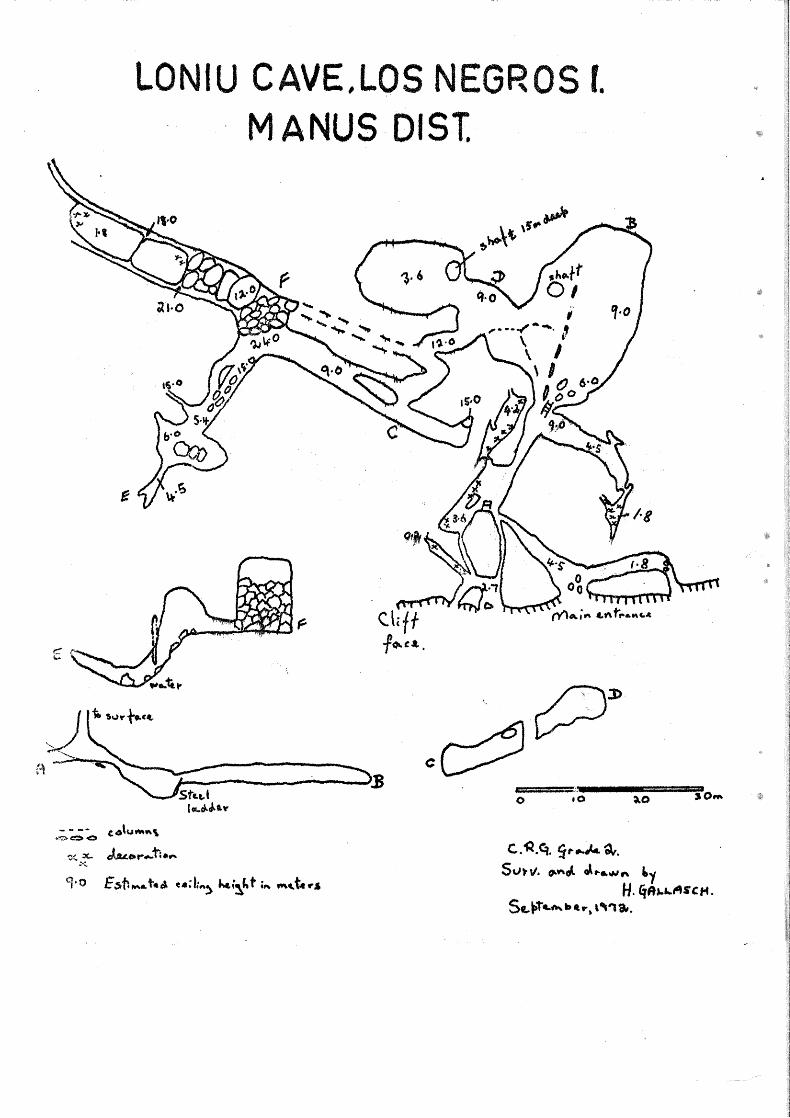
Formerly·, the entrance had besn well hi r; by c· C)To·Nth of rEiinfore:st on and hanging down the cliff face. Hc:;cnt1y, ;-10·:' 1 t::ve:r., a path has been cieared to encourage visi tars. I'Jcr: 1::: cntr~r1 CE· cnn be seen from the rood, some 200m. past Loniu o~ 1 village. In its position on the cliff face looking out to the s0a ~ho cave can be reached by a climb of some 60m. from the road wayD
The: entrance to the cave is partially blocl~cc!. off by ::>everal large, old, weathered columns. Behind these columns a small chamber opons into two narrow tunnels, both of which later emerge in a larger chamber. A narrow crevasse from the surface opens 5n the roof of · this chamber. Pythons sometimes fall down thi~ sh2ft and on a second visit to the cave a large snake 1 was found coiled on 2 narrow ledge in the chamber wall.
Two passages lead of~ this chamber. One tunnel opens into a well-decorated parallel cavorn while the other t2kc~ a steep plunge downwards. This passage opens into a large solution c0vern running transversely to the other caverns. Unfortunately, even h·2re the·re has been disfigurotion of the walls, in the form of L=1:i:'qe .letters and stenciled names.
A.t the extrcmi ty of this cavern a narrow vo::~tic 21 ::,;queez e leads to a small solution passage well decorated w th stalactites, stalogmitcs and small columns. In this ~:~c:ction fi: fibre roots of trees hang into the chamber. The floor is covered with a loose aggregate of leached, porous coron~s~
* cl- D.A.S.F., Keravat, East New Britain.
· I'~i.ugini Cc.ver, J 2_nuary, 197) .•
LONIU CAVE,LOS NEGROS f.
- - -· (4\Umf\\ «~,;,.c:>O
~<. x.. J.uo,-...,11.f" x.
MANUS DIST.
======-·: .•. ---=====~ SOM 0 tO
c.<Q.e:,. ~~.....c.. a,. Sv~v'. fl."'J.. J..,.. .. ..,,.,n 'oy
H. £t1h.1...t1t s c,.. . Se-~t ... ~a•.- .. ,-.,, •.

" .. ,,.· Behind a series of columns a small solution hole leads? down
several meters to where a horizontal squeeze is blocked by stalagmite growth. Some of the best decoration in the cave occurs in the/ · extension through this squeeze. The entrance hole itself is · covered in a brilliant white crystallino flowstone and delicafe ~ stalactites, straws, helicti tes and other c ties adorn the passage.
The climb from the lower cavern up into the main chamber of the cave is facilitated by a steel ladder. Here a large domed chamber of some 70m. x 30m~ is connected to several smaller but .. equally impressive voids" Near the entrance are several groups\of large columns; -hut perhaps the most improssivo feature is a· curt'~.dnlike wall of stalattites and columns stretching the length of th~. chamber. Entry to the adjoining caverns is through holes which occur in this curtain. Apparently water penetration through a single fault in th0 limestone roof has resulted in this v:all-like formation.
This and the adjoining two sections house a large bat · ... population? mostly in small tunnels or shafts off the main chambers. The floor is liberally piled with a mixture of bat guano and mud and it is on this the varied animal life thrives. The rich insect fauna includes swarms of small fliGs ·and cave crickets with antennae up to 20cm. long~ A species of grey crabs, with a body 4-5cm. across, is also commonly found scuttling around the loose coronas on the floor.
In this section of the cave several shnfts appear to connect up with a lower level, but these were not descended.
J From the central chamber a large winding tunnel slopes down to a· lower level where there is a main solution passage. This passage forms a junction (see plan) with another section of the cave resulting primarily from collapse. This is in contrast to the former section where collapse was a very· minor component in cave formation.
One very steep boulder slope leads down to a small collapse chamber, the lowest level in the cave. Over the slope th~ domed ceiling is at places 15m. high. From the side a narrow deep crevasse leads off o This was not pushed. At the lowest level several shallow pools of water occured on gravel, an indication of either a stream bed or the water table. Sloping down from the opposite direction into this chamber was a much smaller tunnel, but this soon became pinched.
It is near the top of this slope that a series of rock £alls has produced a hill of limestone blocks, some 18-20m. high. Following the main direction of the cave there is n large collapse chamber. · It appears .. as though several large blocks, the largest being 23m. x 9m. x 18m.,·fu~y have separated from the ceiling and
fallen i~to the former solution passage. This has left two large crevasse,1 Qfle on either side of the blocks? leading into the distanct. These crevasses appear 18-2lm. deep and th8 extremities have not been explored. Some equipment would ·be needed. While the roof is about 9m. above the boulder slope this distance reduces to 2m. at t~e extent of the fallen blocks. Here also there is a fine gro~p of stalactites and stalagmites.
Although I was obliged to have guides from Loriu village with rot they pref erred to stay in the well known sectors of the cave. The
lotal length of passage way, as measured by pacing, was 660m., but t is considered that further major extensions are awaiting discovery.
- - - - -o Oo - - - ~ .. -
~ Pre 1 i mi n a rU.fil2.~i
R. Michael Bourke * Cave exploration in Papua - Now Guinea is in its infancy and
has mostly been confined to areas readily accessible by road, the JavarGre Caves near Port Moresby and the Chuave area in the highlands being the best known. New 3ritain is included amongst the areas with extensive knrst areas, but about which little is known and even less documented, m~inly because ;~ccess to the limestone areas is di ff icul t. New Britain karst is eJ :c eeded in area in Ni ugini only by the very extensive area in west2rr1 :":)apua extending from the Gulf of Papua northwest through the Darai E:'_lls to the headwaters of the Fly and into Irian Barat in a belt soms 450km. long by lOOkm. wide. From the air, large arGas of continuou:; dolincs are visible, sometimes dissected by deep gorges, and the sidea of soms river valleys are characterized by limestone cliffs often over 300m. tall.' A number of ~mall to moderate sized caves, most.~y stream caves of a simple structure, and a few very large doline!~ that lead into caves, are now known from New Britain.
The island is over 480km. long. Annual rainfall varies from 2286mm. at Rabaul to 6350mm. on the south coast. Geologically it consists of early tertiary rocks, pred~ninantly volcanic pile of andesi tic agglom.erates and flows into which were intruded intermediate plutonic rocks of Oligocent~ age. Much of New Britain is covered by thick limestones of Mioce11e to Pliocene age, the bulk being of Middle Miocene age. Large are~1s of cr0am to white, compact limestone are present as cappings in th~~ Whiteman ranges the Nakanai Mountains and in the Northwest c:;:nelle Peninsula{Baining Mts.). On the Gazelle, smaller areas also occuI~ on the east coast south of
* cl- D.A.S.F., Keravat, East New Brit~1in.
Niuqirii CavGr, Janu~ 1973.
1 ! .
j !
I l
!: ,. I l
f
r
~ .... .
---------...---$----.)' 0 ...._. " . ":-( .
Ni ilgini Ca,ver, J anuary:4 1.2.U
• 'Z.
-·
~ z rn
T ~ 3 A ;· ~
OJ ,,. C/S :J s· ~
:"1-
~ ~ ;o
:p r --J;l 1: --i ~
"' ~ 3
)> c:. p ---~ ~ z ~ "' .·~ p - .' ,.,
, .. ::: ,. '. ' ~' ',
~·
3 ~·.
•. - .
. :~ p <: ~· .("•
r
~~ g-,~
~ I
.,
--V1. ~
()
IT}
: ~ . ' :.:~'. ~.,,:..: :~JI~ . ..::.:.::. .... ....:.~_ :::.;.:.::..:,.;;:::~:.L:: .. ' __
f:age 14
J Cape Gazelle, and in the hinterland south to Wide Bay. Ryburn ( l 97nr) states that the thickness, which varies considerably, is commonly greater than 300m, but in places excee:ds 1500m.
In the Papua •New Guinea caving.literature, there are few references to New Britain. Fisher a'1.d Noakes .( 1942} ·Sta·te ,·that in areas where thick deposits of limestone are involved, as inland from Lau and Jacquinot Bay, solution has been an active factor in erosion, and that solution holes and underground streams are common. According to Champion (1968) "a limestone plateau with caves is reported north of Kandrian, and caves are also reported inland from Pomio and Pondo and south of the Wanangai River". Macnab (1970) has described the limestone of the Gazelle Peninsula. Various authors (e.g. Hosking 1967, Ryburn 1970, Williams 1972) refer to the occurrence of the limestone. Bourke ( 1971, l 972a) 'has described two caving trips to the Baining Mountains and a trip to the Pomio area (1972b).
New Britain caves often contain streams and consist of a single uncomplicated pa.s,s..pge with upper levels or extensive· side passages, suggesting··a relaThiefy youn·g 'age. As is common in many tropical caves, decoration is not well developed although not entirely lacking• One of the most striking features is the abundance of cave life, espec;ially, floor - dwelling insects ·and bats. Several species of bats and £lying foxes can often be found in the one cave in large numbers.
Information on caves visited by the author and one visited by K. Reed and c. Borough is given below according to the three major karst areas~
NAKANAI MOUNTAINS
Stories of great river eff luxes and cave entrances are common for the area inland from Pomio. At the northern end of these mountains there are marked several dolines on the wartime army maps. One is. described as "sinkhole approx. 1500' deep" and another as "sinkhole approx. 1250' deep". Chris Borough and Kevin Reed of the Port Moresby Speleological Society investigated the latter in 1968. The doline is almost circular and was estimated as 300~600m. deep. The sides are almost vertical. They descended to about 60m. above the bottom to where the sides became too steep to go further without more than a single line. On the floor of the doline a river emerges from one cave and disappears into another. Both entrances are about 25m •. high •. About 1600m. from the doline one branch of Pandi river ·enlerges from a cave near Tuke village •
. . . ' ··-·-~...:.
Niugini Caver, January 1 1973. ...................... ~ge 15

The other larg~- sinkho}~ marked bn ~he maps wa~ irivestigated by the author in April 1972 (Bourke 1972b) and by· the University of Queensland Speleological Society·' s expedition in-; December 1972 -January 1973. _ The doline is app~ox. 1500m •. long and is 260m. deep~ There is a- c-ave with a large river in~ t at_ tfle bottom which was explored for ·610m. The "river emerges about l.500rri• ·away ·in· a cliff face 55m. up and forms one b·ranch of the Ests· River ·(pr6h. Isso) o
Seven kilometrE.?sf ·oo·rth ~ast of Pomio· -thers is ancrfher huge sinkhole with a river °'."'; :p:~.8J??b~y the Matali :-. f lo~ing_~ ?fross the .. bottom. From ·near Nutuv-e mrssion yet another dolin_e ~s· reported t--,y the villagers and was sighted from the air by Lex Brown of the UQSS expedi tj.00 •. , .
Sm731.J..e.~:.·C_?V~s .. ~:~r:~:_: ;r.%~_or_t:ed · f ram near Pomio. ' ·. . . '} :,) '. .. ·· . .:.. ( ·...... 1 ~ '··-~ .J .. . } .:. : ~ - : ·. . ··.
This c~m.sJJts C)f 'the Baining Mountain$. and a very fertile area ~f recent \/olci:1hic.s: in" the nq,tth~east pp~tiDh 's··epara'tec~t fr,om the mountains by the· yYa~~ng9.~i< ~m~:t Kerayat Hl,Yer valleys.·. ·· ·. .
Th~-- R-~~~-~J-: R~n'ge J·0;. t·h~~. N_o;~tb· Bain,~.0:~ ;_Mounb0in_s -~n _ the northwcs t part o·f Jh'e:· ~-?-~rnlJ_e: :·r1·se·9 to lB30Q1,• .. &rppv-c. se? level·. ·Along the eastern edge· o.f J'h_~~'; tan-g:e, the;te· are: l~'[N~,s .. t6'ne. ~liff s 75Qm •. hJgh. The limestone is middle ·and possibly Upp·er"M'iocene ·in age and. ~s more than lOOOm. thick. It is mostly shallow dipping. Widely sp~ced ·horizontal 8nd yert.ical. join_t,ing, ~.as - l:>~~r1 not?d~ ... It oµtc;rops over 600 sq. kr;1')
(Macnab 1970) .~ .. , 'T~1:e' surfac~~ ',t_pp9g~app\r:~-iP1 .cb.fra.~ te'.r.iz ed by .:innumerable con~inuous do.lines: c_9v~,.r:e_q1ih.Jfop·~:-~:a1;,:~D:o.:·s&?me···m9·ss for;~_$t'" ~ As well as this karst, ·c:r:ev.'i~·e"'..1~arst.~·,O'Q9J:tr~ Wh?'t$."lhe ·s-u:Cfact _n; d+ssected by fissures up to "J5m:~· d~I~·p·. · ~:· ., :i.<. -~ "·'' ,, :. · ·.· / ·.· "··
' . ~ .i ,., ·, ; ' ·~ .. : '~ . .• } ;, .. , : . ..,) • \~· .:·:. i. J . .. . . ~/. '. .. l r~ ;: . ;_r . r: •·· . ·~ ~ . .. . ; .
· OnlY._?: fra·c·fion •. 0Lth~·ar.$_:b.h1al>p~·~r8.r:~.;<:plored for 'ca:ves. Nine caves are 'knoW'h', n:on·e·: deeper tha·n · 24m~ · (Bou'rke 1972a). The caves are vertical in nature, and most dolines are soil filled or contain small caves that are blocked. Stream eff luxes occur in the adjacent lowlands down to sea le~_e..l:i.L .. _ ... Ih:G~;~g:§pJ~b.tE?.f:~·.JJJ§:; __ Ji_m-e..~.tone 8nd altitude contrast suggest that nonblocked systems would be very deep~
Other caves are known at lower altitudes in the same area. An hour's.walk from Yalum village (ea. 900m.) there is a small cave lOOm ... ,l9ng ,(Orcat.:.$atadat). Two hour's walk from Alacasam vill09E? (520m.:. ),:.J·¥_.,_1·Q_p:rp;r;l,ing'er0m. Cave, about 460m_. long. A ·.s.rnaller one is r.c.ported f1E?arfi.V:'the.village. rn this- area·, many..-o.f the str2ams ... are· dammed by impre's's1 ve travertine depo:si ts. , Cav·es ·(3re reported in the vicinity of Wilumbinki village and, in fact, this: area corresponds to Champion's "in:lqO:d from Pqpdo".
·u .<~ .. :-<~;.· ;« .: ;> ... '. ~ ;_:· . , .. '., •.
Niugini Caver, .3,anuaty,_];973~: ··" ~. ···, :::· . . · Pa~_l.§ --·1 ·~· · .. · .... t ...., ·:.. .. -·~ -· .... :..,, ... ·. __ . ;. r ··~··: ) ·_1 (
' ' . ·~
The Yalum limestone series also f oxms steep rugged hills with karst topography immediately east of Lassaul Bay. Behind Matanakunei village in Open Bay, Pliocene limestone more than 200m. , thick covers an area of 40 sq~km. and forms the highest point of the'· Lakit Range about 845m. above sea level. The topography is karst and steep slopes, or cliffs bound the unit except on the north west side (Macnab 1970).
Three river caves are known in limestone in the Gaulin area .. , on the edge of the Bainings. The area is relatively not so mountainous and is accessible by road, in contrast to the for.ement areas on the Gazelle where 1•3 days walking ;Ls necessary. One of"·the caves { Luminas) is l50m. long, ano. thex (Synnongoinga) is l50m. and '1-iB third (Durwy) . is 75m. long. Th·er.e.· are others in the area according¥? to village people. Altitude .. would be less than 300m.
South of the Warangoi River, at least one cave is reported by village people 1 klostut Simbum village. The area is coveied with Pleistocene reef-shoal limestone.
There are sea caves in the Pleistocene reef limestone on Mioko and Duke of York Islands in the Duke of York Group between,. RabauL q_nd New Ireland. . Coralline Limestone _is known. in .Niu_gini as coronas. ·
The Rembarr Range is composed of limestone with a thin veneer of volcanic ash. Peaks are up to 404m. A.S.L. Local politi problems have prev~nted investigation of reported caves here~
Also on the Gazelle are caves formed in the pumice subsoil by stream action. They are from 6 to 15m. underground and boast passages and chambers. Near Malabunga High School, three caves are known, being 37m., 28m. and 25m. long respectively. The former two contain streams. Comunga Cave near Taulil village is another such cave and is about l8m. long. Another one has been formed by a line of weakness in c.onsolidated sand and pumice of volcanic origin. An interesting feature of -these caves is the presence of charcoal in the parent material, presumably timber burnt when the material was deposited. This charcoal should allow the deposits to be carbon dated.
Inside the crater of Matupit volcano at Rabaul there is a 1
small cave beautifully decorated with a variety of minerals displayin! orange, cream and green. colours. Desp~te the number of visitors to 1
the volcano, the ~inerals are well-preserved· as access to the cave i:s I fortunately not easy. j\t many locations near Rabaul there are tunnels[ dug for the wartime occupation 0f the Japanes·e army, in the soft pumic! Some are quite extensive and contained-facilities for long occupationt
N iugini Caver 1 J anuar:t:, 1973.
THE WHITEMAN RANGE
Few details are known, but the limestone is extensive (see map). Reports of caves are numerous. The Alimbit River emerges from a cave inland from Ka.ndrian.
BOURKE, R.M.
CHAMPION, C.R.
FISHER N.H. &
( 1971)
REFERENCES -Baining Mountains, N. W. Gazelle Peni:t;tst._1a New Britain, T.P.N.G. Down Und~ .12 \4) 111-113 (also published in ASF News! .. 54: 1 5-16)
(1972a)~ Raulei Range, Baining Mountains, New Britain, T .P .N .G. ~!L~~!: 11 ~ 11-1 ~~
(1972b)~ Ora Cave, New Britain. SUSS Bull.12 (3)~ 29 (also published in AS~ws175;-~3) ........................................
(1968) ~ Caving and Karst Areas in Papua and New Guinea (in) .§.Eeleo_;f!~££.£.2f ed. P. Matthewsi Australian Speleological Federation, Sydney.
NOAKES L.C. (1942) Geologica~~LReports on New Britain. ~errJ New Guinea Geol, Bull. No.:.1.
HOSKDtG, J. S. ( 1967)
MA CNA B , R • P • ( 1 9 7 0 )
RYBURN, R.J. (1970)
WILLIAMS, P.W. (1972)
Limestone and Lime in the Territory of Papua and New Guinea. CSIRO Div. ~~.£h:.-~J22r 21. - ~~-~ Geology of the Gazelle Peninsula, T.P.N.G. Bur. Min. Res. Record 1970/63. -- - ------Notes to accompany Geological Crustal Studies Map of New Britain and New Ireland. Bur. Min. Re~. Morphometric Analysis of Polygonal Karst in New Guinea. Geol. Surv. Amer._]~11· §1 : 791-79b (MarCh 1972)
fill!-gini . Caver, Januapy i·· ·1 97j;. . . · Pa&§'. .l§ , ••• 1 • . . •
..J- •••
,,....... ,,... ... ~ ... , ..
AIR NiAIL *">-~~·'i': 4 . I ·-
I:F.:' ··unclaimed please return to R .M. Bourke, D .A. S. F. , Kera vat, E .. N E .. Papua New Gu.in e1>·
Credit to: Typing: Mrs. R.M. Gregory Cover : David Loh