1. MODIS Snow Cover 2. Application for Extracting and ... · Exploring Analysis-Ready Samples...
15
U.S. Department of the Interior U.S. Geological Survey 1. MODIS Snow Cover 2. Application for Extracting and Exploring Analysis-Ready Samples (AppEEARS) Tom Maiersperger Geographer, USGS NASA LP DAAC Project Scientist USGS EROS Center Sioux Falls, South Dakota [email protected]
Transcript of 1. MODIS Snow Cover 2. Application for Extracting and ... · Exploring Analysis-Ready Samples...

U.S. Department of the InteriorU.S. Geological Survey
1. MODIS Snow Cover2. Application for Extracting and Exploring Analysis-Ready Samples (AppEEARS)Tom MaierspergerGeographer, USGSNASA LP DAAC Project ScientistUSGS EROS CenterSioux Falls, South [email protected]

LP DAACSurface Reflectance,
Land Cover, Vegetation Indices

https://lpdaac.usgs.gov

https://lpdaac.usgs.gov/dataset_discovery/

§ Moderate Resolution Imaging Spectroradiometer (MODIS)§ On board NASA’s Terra (10:30 am) and Aqua (1:30 pm)
satellites
Temporal Extent 2000 (Terra), 2002 (Aqua) - PresentTemporal Resolution Near-dailyGeographic Extent Global
Spatial Resolution 250 m, 500 m, 1,000 m, 5,600 m
Versioning Currently in v6 (v5 will be retired)
MODIS Quick Facts

MODIS L2G Data Structure
MODIS Sinusoidal Tile Grid. Tiles cover 10° x 10° at the equator or approximately 1200 km by 1200km.
Tiles are archived in Hierarchical Data Format (HDF)
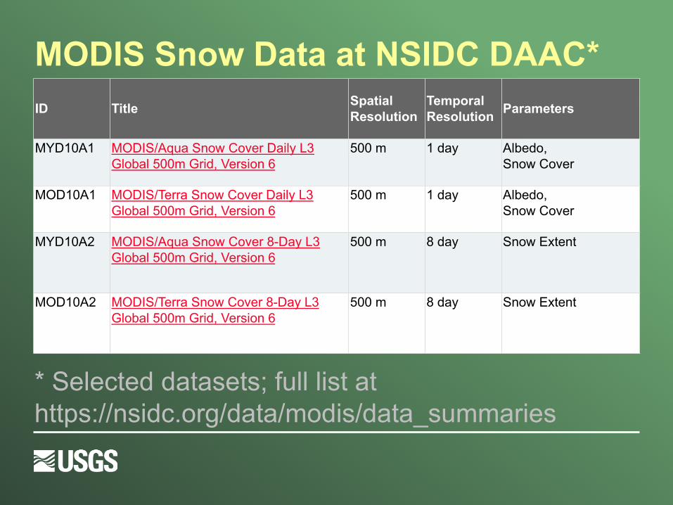
MODIS Snow Data at NSIDC DAAC*
§ https://nsidc.org/data/modis/data_summaries#snow
ID Title Spatial Resolution
Temporal Resolution Parameters
MYD10A1 MODIS/Aqua Snow Cover Daily L3 Global 500m Grid, Version 6
500 m 1 day Albedo,Snow Cover
MOD10A1 MODIS/Terra Snow Cover Daily L3 Global 500m Grid, Version 6
500 m 1 day Albedo,Snow Cover
MYD10A2 MODIS/Aqua Snow Cover 8-Day L3 Global 500m Grid, Version 6
500 m 8 day Snow Extent
MOD10A2 MODIS/Terra Snow Cover 8-Day L3 Global 500m Grid, Version 6
500 m 8 day Snow Extent
* Selected datasets; full list at https://nsidc.org/data/modis/data_summaries

AppEEARS Fast Facts
Application for Extracting and Exploring Analysis-Ready Samples
Led by the NASA Land Processes Distributed Active Archive Center (LP DAAC), but also leverages other federal archive partnerships to extend the capability across a larger network of source data

AppEEARS ValueüSignificantly reducing data volumes, at-archive, based on
user-defined space-time-variable subsetsüPromoting interoperability across a wide variety of
datasets via format and coordinate reference system harmonization
üIncreasing the velocity of data analysis by providing harmonized data bundles and of data insight by allowing interactive exploration of extracted datasets
üEnsuring the veracity of data by making quality measures more apparent and usable, by generating standards-based metadata, and by providing data and processing provenance

AppEEARS Datasets
§ Current: Over 100 unique datasets from MODIS, SRTM, and Landsat WELD
§ In Progress: § DAYMET (source archive: ORNL)§ Gridded Population of the World (SEDAC)§ NASA VIIRS Land Datasets (LP DAAC)§ Landsat Level-2 Surface Reflectance (USGS)
§ Potential Future: NLCD (USGS), SMAP (NSIDC)…

Example Request: EXTRACTING and EXPLORING a POINT-BASED SAMPLE
§ Variables of Interest: § MODIS Daily Snow Cover (MOD10A1.006)§ MODIS 4-Day FPAR (MCD15A3H.006)
§ Points of Interest: 40 AmeriFlux tower locations within the MCI
§ Date Range of Interest: 2010 – 2012 § Output File Format: CSV§ Set-up Time: < 10 minutes; Total Processing Time at-
Archive: ~6 hours§ Data Volume Reduction: ~90,000x (~26 GB of input
processed to ~320 KB of output)§ Number of Archives Queried: 2 (LP DAAC, NSIDC)

Example Results: EXTRACTING and EXPLORING a POINT-BASED SAMPLE
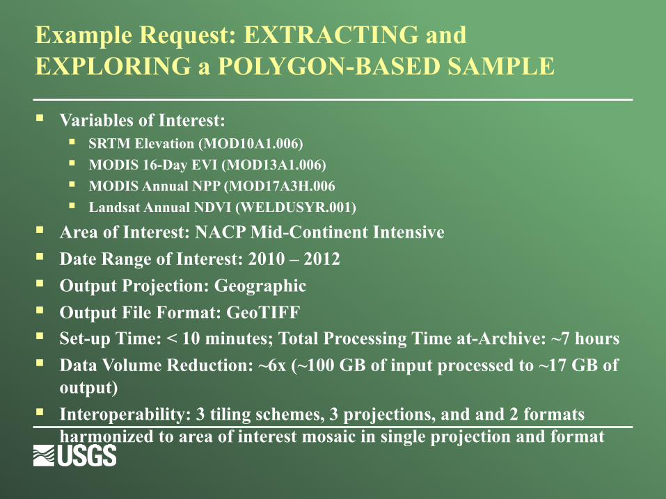
§ Variables of Interest: § SRTM Elevation (MOD10A1.006)§ MODIS 16-Day EVI (MOD13A1.006)§ MODIS Annual NPP (MOD17A3H.006§ Landsat Annual NDVI (WELDUSYR.001)
§ Area of Interest: NACP Mid-Continent Intensive § Date Range of Interest: 2010 – 2012 § Output Projection: Geographic § Output File Format: GeoTIFF§ Set-up Time: < 10 minutes; Total Processing Time at-Archive: ~7 hours§ Data Volume Reduction: ~6x (~100 GB of input processed to ~17 GB of
output)§ Interoperability: 3 tiling schemes, 3 projections, and and 2 formats
harmonized to area of interest mosaic in single projection and format
Example Request: EXTRACTING and EXPLORING a POLYGON-BASED SAMPLE
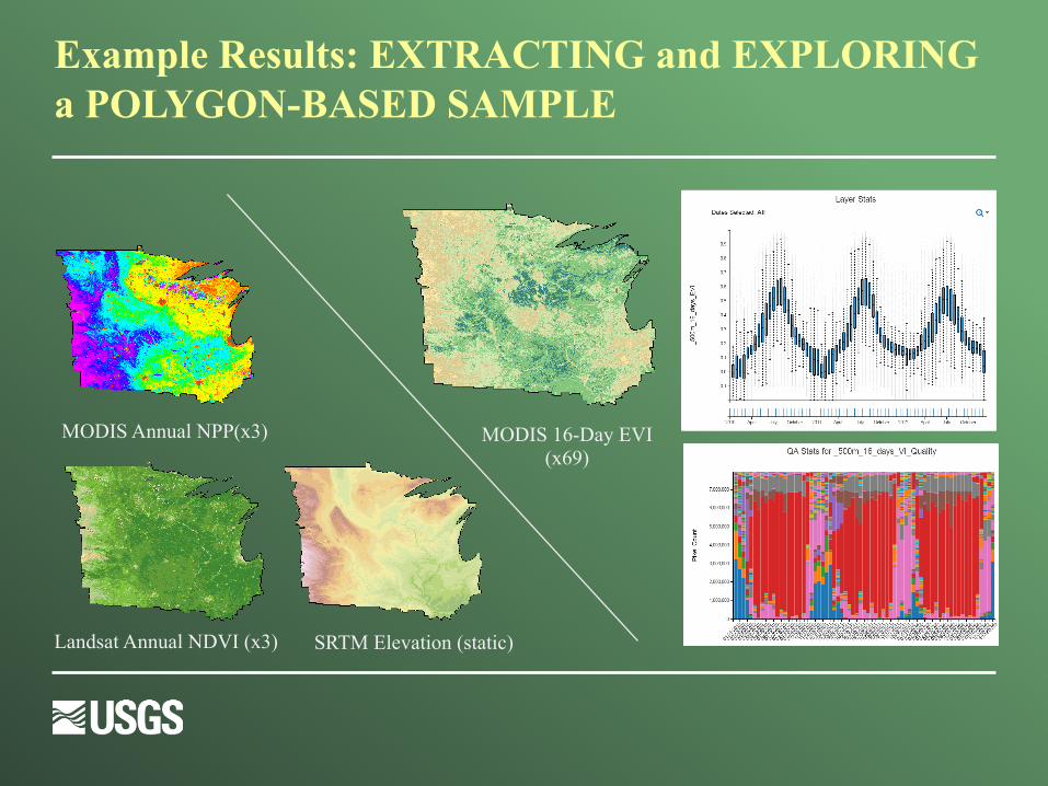
Example Results: EXTRACTING and EXPLORING a POLYGON-BASED SAMPLE
SRTM Elevation (static)Landsat Annual NDVI (x3)
MODIS Annual NPP(x3) MODIS 16-Day EVI (x69)

AppEEARS Demo
https://lpdaacsvc.cr.usgs.gov/appeears/
Point (operational)Polygon (alpha – publicly available ~ May 2017)