1 CleanSeaNet : The EU satellite service for monitoring and surveillance of illegal oil discharges...
27
1 CleanSeaNet: The EU satellite service for monitoring and surveillance of illegal oil discharges Samuel Djavidnia European Maritime Safety Agency [email protected]
-
Upload
hugo-greene -
Category
Documents
-
view
215 -
download
1
Transcript of 1 CleanSeaNet : The EU satellite service for monitoring and surveillance of illegal oil discharges...

1
CleanSeaNet:
The EU satellite service for monitoring and surveillance of illegal oil discharges
Samuel Djavidnia
European Maritime Safety Agency
2
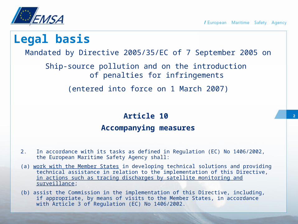
Mandated by Directive 2005/35/EC of 7 September 2005 on
Ship-source pollution and on the introduction of penalties for infringements
(entered into force on 1 March 2007)
Article 10
Accompanying measures
Legal basis
2. In accordance with its tasks as defined in Regulation (EC) No 1406/2002, the European Maritime Safety Agency shall:
(a) work with the Member States in developing technical solutions and providing technical assistance in relation to the implementation of this Directive, in actions such as tracing discharges by satellite monitoring and surveillance;
(b) assist the Commission in the implementation of this Directive, including, if appropriate, by means of visits to the Member States, in accordance with Article 3 of Regulation (EC) No 1406/2002.
3
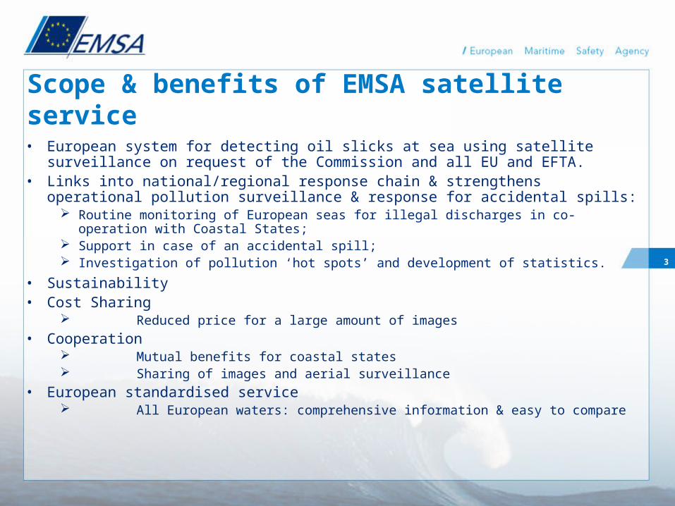
• European system for detecting oil slicks at sea using satellite surveillance on request of the Commission and all EU and EFTA.
• Links into national/regional response chain & strengthens operational pollution surveillance & response for accidental spills:
Routine monitoring of European seas for illegal discharges in co-operation with Coastal States;
Support in case of an accidental spill; Investigation of pollution ‘hot spots’ and development of statistics.
• Sustainability• Cost Sharing
Reduced price for a large amount of images• Cooperation
Mutual benefits for coastal states Sharing of images and aerial surveillance
• European standardised service All European waters: comprehensive information & easy to compare
Scope & benefits of EMSA satellite service
4
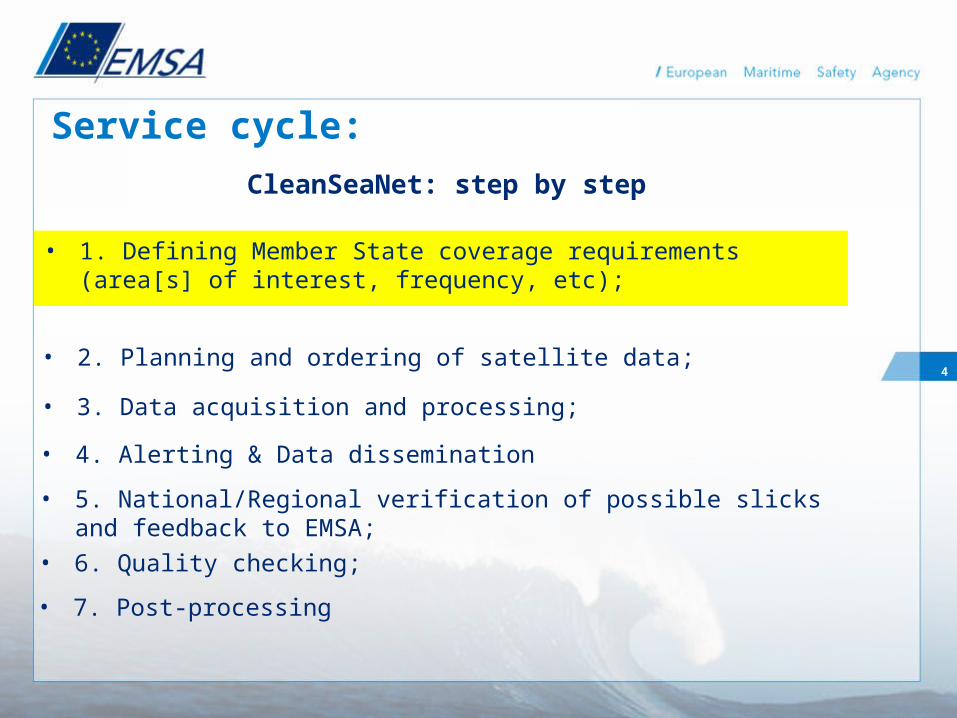
Service cycle:
• 2. Planning and ordering of satellite data;
CleanSeaNet: step by step
• 1. Defining Member State coverage requirements (area[s] of interest, frequency, etc);
• 4. Alerting & Data dissemination
• 3. Data acquisition and processing;
• 5. National/Regional verification of possible slicks and feedback to EMSA;
• 7. Post-processing
• 6. Quality checking;

5
CleanSeaNet users
• 23 Coastal States are currently part of the CleanSeaNet service:
Baltic Sea: FI, SE, EE, LV, LT, PL, DK, DE North Sea: DE, DK, NO, UK, NL, BE Atlantic: UK, IE, FR, ES, PT Black Sea: BG, RO Mediterranean Sea: ES, FR, IT, SI, MT, CY, EL NW Atlantic: UK Norway North: NO
6
Service cycle:
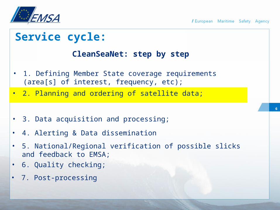
• 2. Planning and ordering of satellite data;
CleanSeaNet: step by step
• 1. Defining Member State coverage requirements (area[s] of interest, frequency, etc);
• 4. Alerting & Data dissemination
• 3. Data acquisition and processing;
• 5. National/Regional verification of possible slicks and feedback to EMSA;
• 7. Post-processing
• 6. Quality checking;
7
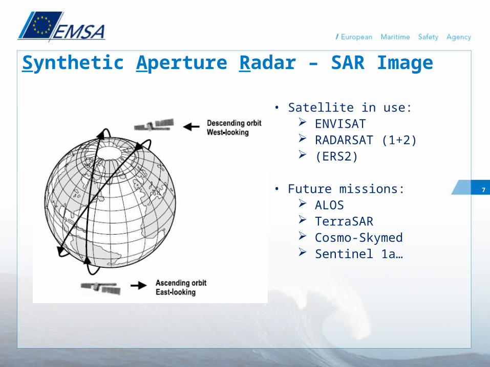
Synthetic Aperture Radar – SAR Image
• Satellite in use: ENVISAT RADARSAT (1+2) (ERS2)
• Future missions: ALOS TerraSAR Cosmo-Skymed Sentinel 1a…

8
Coverage of each point
00.20.40.60.811.21.41.6
253035404550556065707580Latitude
Freq
uenc
y pe
r day
ENVISAT
RADARSAT 1/2ScanSARNarrow
RADARSAT 1/2ScanSAR Wide
Satellite maximum service area

9
Service cycle:
• 2. Planning and ordering of satellite data;
CleanSeaNet: step by step
• 1. Defining Member State coverage requirements (area[s] of interest, frequency, etc);
• 4. Alerting & Data dissemination
• 3. Data acquisition and processing;
• 5. National/Regional verification of possible slicks and feedback to EMSA;
• 7. Post-processing
• 6. Quality checking;

10
CleanSeaNet: network
Tromsø
Matera
Azores(from 2008)
Fucino
Benevento
Svalbard
Grimstad

11
CSN Processing & Oil Analysis
• ENV & RS1 Raw data -> L0 -> L1 16 bits ENV WideSwath: 400x400km, 150m resolution RS1 ScanSAR Narrow: 300x300km, 75m resolution
• Wind & wave processing: SARTooL
• AIS Integration
• (Vessel detection)
• Oil analysis: visual / semi-automatic technique (Tromso-KSAT, Matera-Telespazio and Lisbon-Edisoft)

12
Service cycle:
• 2. Planning and ordering of satellite data;
CleanSeaNet: step by step
• 1. Defining Member State coverage requirements (area[s] of interest, frequency, etc);
• 4. Alerting & Data dissemination
• 3. Data acquisition and processing;
• 5. National/Regional verification of possible slicks and feedback to EMSA;
• 7. Post-processing
• 6. Quality checking;
13
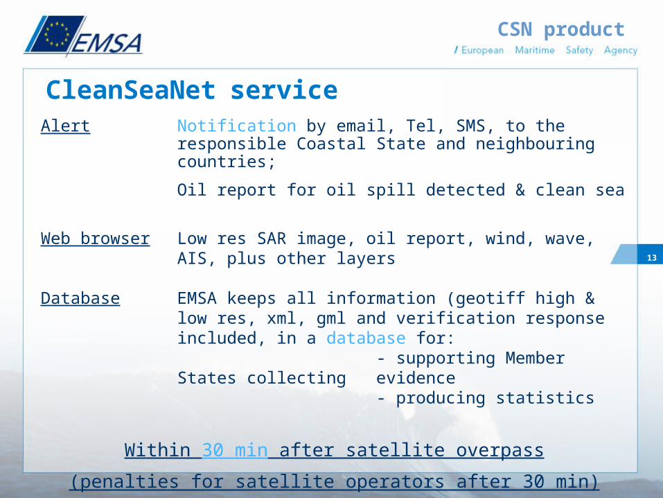
Alert Notification by email, Tel, SMS, to the responsible Coastal State and neighbouring countries;
Oil report for oil spill detected & clean sea
Web browser Low res SAR image, oil report, wind, wave, AIS, plus other layers
Database EMSA keeps all information (geotiff high & low res, xml, gml and verification response included, in a database for:
- supporting Member States collecting evidence
- producing statistics
Within 30 min after satellite overpass
(penalties for satellite operators after 30 min)
CleanSeaNet service
CSN product

14
CSN Web Portal

15
Service cycle:
• 2. Planning and ordering of satellite data;
CleanSeaNet: step by step
• 1. Defining Member State coverage requirements (area[s] of interest, frequency, etc);
• 4. Alerting & Data dissemination
• 3. Data acquisition and processing;
• 5. National/Regional verification of possible slicks and feedback to EMSA;
• 7. Post-processing
• 6. Quality checking;

16
Feedback & verification
©MDA/CSA/EMSA 2007
EMSA CleanSeaNetRADARSAT-1 2007-10-07
© Italian Coastguard aerial verification
Oil spills

17
Service cycle:
• 2. Planning and ordering of satellite data;
CleanSeaNet: step by step
• 1. Defining Member State coverage requirements (area[s] of interest, frequency, etc);
• 4. Alerting & Data dissemination
• 3. Data acquisition and processing;
• 5. National/Regional verification of possible slicks and feedback to EMSA;
• 7. Post-processing
• 6. Quality checking; Timeliness Completeness Quality

18
Service cycle:
• 2. Planning and ordering of satellite data;
CleanSeaNet: step by step
• 1. Defining Member State coverage requirements (area[s] of interest, frequency, etc);
• 4. Alerting & Data dissemination
• 3. Data acquisition and processing;
• 5. National/Regional verification of possible slicks and feedback to EMSA;
• 7. Post-processing
• 6. Quality checking;
19
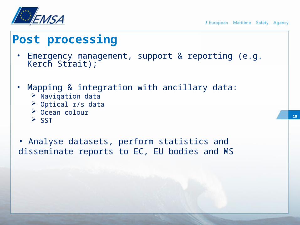
Post processing• Emergency management, support & reporting (e.g. Kerch
Strait);
• Mapping & integration with ancillary data: Navigation data Optical r/s data Ocean colour SST
• Analyse datasets, perform statistics and disseminate reports to EC, EU bodies and MS

20
CleanSeaNet Examples (i)
EMSA CleanSeaNetRADARSAT-1 2007-10-07 03:52 UTC
21
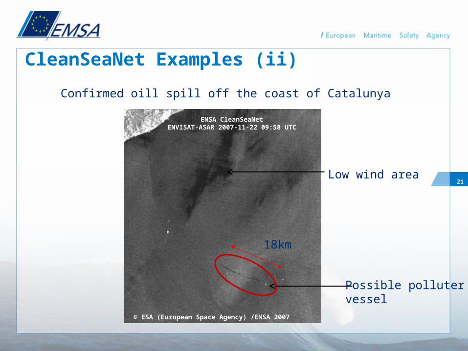
18km
CleanSeaNet Examples (ii)
© ESA (European Space Agency) /EMSA 2007
EMSA CleanSeaNetENVISAT-ASAR 2007-11-22 09:58 UTC
Low wind area
Possible pollutervessel
Confirmed oill spill off the coast of Catalunya

22
CleanSeaNet Operational Support - Emergencies: New Flame
To monitor the New Flame incident (Sept. 07), EMSA specifically ordered ENV & RS1 scenes and issued CleanSeaNet briefings to the Spanish Authorities (SASEMAR), to DG ENV (MIC) and DG TREN

23
CSN: the international institutional context• Development of the service:
European Space Agency (ESA): MARCOAST, Data Access Joint Research Centre (JRC - European Commission)
• Operational cooperation (emergency): MIC, DG Environment, European Commission International Charter on Space and Major Disasters
– The ‘Charter’ is a mechanism to co-ordinate space based data acquisition and delivery to those affected by a natural or man made disaster anywhere in the world (earthquakes, floods, fires..)
– Charter Members –CSA, CNES, ESA, NOAA, JAXA, ISRO…– In the case of a large oil spill in European waters, EMSA will be
the focal point for producing Charter Products, e.g. Strafjord-A Platform accident in Norway, Dec. 07.
24
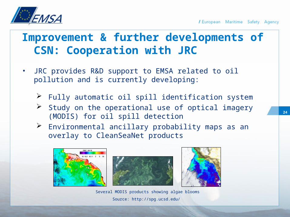
Improvement & further developments of CSN: Cooperation with JRC
• JRC provides R&D support to EMSA related to oil pollution and is currently developing:
Fully automatic oil spill identification system Study on the operational use of optical imagery (MODIS) for
oil spill detection Environmental ancillary probability maps as an overlay to
CleanSeaNet products
Several MODIS products showing algae blooms
Source: http://spg.ucsd.edu/

25
CleanSeaNet: service development• In-house capability of combination with AIS (SRIT) (2008). AIS
Mediterranean regional server
• Capability of forecasting and hindcasting of spill drift, aging of spills (2008)
• Correlation of vessel tracks and spill movements needed
• EMSA service might be the first operational end-to-end service for Member States under GMES
• Service could be further developed for vessel detection/identification by satellite
• Long Range Identification & Tracking ?

2610:00
10:00
9:00
8:00
9:00
7:00
7:008:00
9:00
10:00
10:00
8:00
CleanSeaNet: Advanced products
Combination of
- Satellite detection
- Spill drifting
- Vessel tracking

27
CleanSeaNet web portal:
http://cleanseanet.emsa.europa.eu
First test image CleanSeaNet
c) CSA/MDA/EMSA Radarsat 11/04/2007