06 Pt6 Zones 6.1-6.5 VTBD Package3 2020-6-16
139
LIVINGSTONE PLANNING SCHEME 2018 Livingstone Shire Council Livingstone Planning Scheme 2018 Version 2TBD Page P6-1 Part 6. Zones 6.1. Preliminary (1) Zones organise the planning scheme area in a way that facilitates the location of preferred or acceptable land uses. (2) Zones are mapped and included in Schedule 2. (3) The categories of development and assessment for development in a zone are in Part 5. (4) Assessment benchmarks for zones are contained in a zone code. (5) A precinct may be identified for part of a zone. (6) Precinct provisions are contained in the zone code. (7) Each zone code identifies the following: (a) the purpose of the code; (b) the overall outcomes that achieve the purpose of the code; (c) the performance outcomes that achieve the overall outcomes and the purpose of the code; (d) the acceptable outcomes that achieve the performance outcomes and overall outcomes and the purpose of the code; and (e) the overall outcomes, performance outcomes and any acceptable outcomes for development in a designated zone precinct. (8) The following are the zone codes for the planning scheme: (a) Centre category zone codes: (i) Neighbourhood centre zone code; (ii) Local centre zone code; (iii) District centre zone code; (iv) Major centre zone code; (b) Environmental category zone codes: (i) Environmental management and conservation zone code; (c) Industry category zone codes: (i) Low impact industry zone code: (A) the code contains outcomes for zone precinct ZP-11 – Tanby Road Local Business Precinct; (ii) Medium impact industry zone code; (d) Other category zone codes: (i) Community facilities zone code; (ii) Emerging community zone code; (iii) Limited development zone code; (iv) Rural zone code: (A) the code contains outcomes for zone precinct ZP-01 - Capricorn Coast Rural Precinct; (B) the code contains outcomes for zone precinct ZP-13 – Yaamba Historic Township Precinct; (v) Rural residential zone code:
Transcript of 06 Pt6 Zones 6.1-6.5 VTBD Package3 2020-6-16
LIVINGSTONE PLANNING SCHEME 2018
Livingstone Shire Council Livingstone Planning Scheme 2018 Version 2TBD Page P6-1
Part 6. Zones
6.1. Preliminary
(1) Zones organise the planning scheme area in a way that facilitates the location of preferred or acceptable land uses.
(2) Zones are mapped and included in Schedule 2.
(3) The categories of development and assessment for development in a zone are in Part 5.
(4) Assessment benchmarks for zones are contained in a zone code.
(5) A precinct may be identified for part of a zone.
(6) Precinct provisions are contained in the zone code.
(7) Each zone code identifies the following:
(a) the purpose of the code;
(b) the overall outcomes that achieve the purpose of the code;
(c) the performance outcomes that achieve the overall outcomes and the purpose of the code;
(d) the acceptable outcomes that achieve the performance outcomes and overall outcomes and the purpose of the code; and
(e) the overall outcomes, performance outcomes and any acceptable outcomes for development in a designated zone precinct.
(8) The following are the zone codes for the planning scheme:
(a) Centre category zone codes:
(i) Neighbourhood centre zone code;
(ii) Local centre zone code;
(iii) District centre zone code;
(iv) Major centre zone code;
(b) Environmental category zone codes: (i) Environmental management and conservation zone code;
(c) Industry category zone codes: (i) Low impact industry zone code:
(A) the code contains outcomes for zone precinct ZP-11 – Tanby Road Local Business Precinct;
(ii) Medium impact industry zone code;
(d) Other category zone codes: (i) Community facilities zone code;
(ii) Emerging community zone code;
(iii) Limited development zone code;
(iv) Rural zone code:
(A) the code contains outcomes for zone precinct ZP-01 - Capricorn Coast Rural Precinct;
(B) the code contains outcomes for zone precinct ZP-13 – Yaamba Historic Township Precinct;
(v) Rural residential zone code:

LIVINGSTONE PLANNING SCHEME 2018
Livingstone Shire Council Livingstone Planning Scheme 2018 Version 2TBD Page P6-2
(A) the code contains outcomes for zone precinct ZP-02 – Park Residential Precinct;
(vi) Special purpose zone code:
(A) the code contains outcomes for zone precinct ZP-03 – Rosslyn Bay Precinct;
(vii) Specialised centre zone code;
(viii) Township zone code;
(e) Recreation category zone codes: (i) Open space zone code:
(A) the code contains outcomes for zone precinct ZP-04 – Yeppoon Foreshore Tourism and Recreation Precinct;
(ii) Sport and recreation zone code;
(f) Residential category zone codes:
(i) Low density residential zone code:
(A) the code contains outcomes for zone precinct ZP-05 – Tanby Road Commercial Transition Precinct;
(B) the code contains outcome for zone precinct ZP-12 – Kinka Local Business Precinct;
(ii) Low-medium density residential zone code:
(A) the code contains outcomes for zone precinct ZP-06 – Cooee Bay Accommodation Precinct;
(iii) Medium density residential zone code:
(A) the code contains outcomes for zone precinct ZP-07 – Rosslyn Bay Accommodation Precinct;
(B) the code contains outcomes for zone precinct ZP-08 – Major Centre Commercial Transition Precinct;
(g) Tourism category zone codes: (i) Major tourism zone code:
(A) the code contains outcomes for zone precinct ZP-09 – Capricorn International Resort Precinct; and
(B) the code contains outcomes for zone precinct ZP-10 – Great Keppel Island Precinct.

LIVINGSTONE PLANNING SCHEME 2018
Livingstone Shire Council Livingstone Planning Scheme 2018 Version 2TBD Page P6-3
6.2. Centre category zone codes
6.2.1. Neighbourhood centre zone code
6.2.1.1. Application
This code applies to the assessment of development if it is identified as an applicable code for development, as specified in the assessment benchmarks column in the tables of assessment located in Part 5 of the planning scheme.
When using this code, reference should be made to section 5.3.2 and where applicable, section 5.3.3 located in Part 5 of the planning scheme.
All subject matter in this code is applicable to the development assessment, unless the following circumstance arises:
(1) The heading of a specific benchmarks for assessment table specifies otherwise; or
(2) A heading within a specific benchmarks for assessment table specifies that the outcomes apply to a specific type of development or to development at a specific location; or
(3) A performance outcome or acceptable outcome specifies that the outcomes apply to a specific type of development or to development at a specific location.
In the circumstance where point (2) or point (3) above arises the following applies:
(1) the development assessment outcomes apply only to the type of development specified or only to development at the location specified; and
(2) the development must still be assessed against all other general subject matter of the code (for example, assessment benchmarks including but not limited to those relating to built form, appearance, or general land use).
6.2.1.2. Purpose
The purpose of the neighbourhood centre zone code is:
(1) to identify the desired character and amenity for the zone and to protect it from incompatible development;
(2) to provide for the development of highly accessible small scale neighbourhood centres which service a trade catchment of approximately 1500 households;
(3) to provide for the development of neighbourhood centres as places comprising small-scale uses from within the centre activities group (where they serve the convenience needs of the immediate residential area);
(4) to provide for the development of a limited range and mixture of other uses where they are compatible with preferred uses and they support the needs of the immediate residential area;
(5) to provide for the management of impacts on adjoining sensitive land use; and
(6) to facilitate the achievement of the overall outcomes sought for the zone.
6.2.1.3. Overall outcomes
The purpose of the code will be achieved through the following overall outcomes:
(1) the development is:
(a) a use within the centre activities group which:
(i) is small in scale; and
(ii) services only the convenience (day to day) needs of residents of the immediate area; or
(b) a use that is not within the centre activities group which:
(i) is small in scale;

LIVINGSTONE PLANNING SCHEME 2018
Livingstone Shire Council Livingstone Planning Scheme 2018 Version 2TBD Page P6-4
(ii) has low impacts;
(iii) is compatible with preferred uses from within the centre activities group;
(iv) does not limit or compromise the development preferred uses from within the centre activities group within the centre; and
(v) services only the convenience (day to day) needs of residents of the immediate area;
(2) the development of a use within the centre activities group is a preferred use within the zone in the following circumstances:
(a) it is a food and drink outlet and it does not involve a drive through facility; or
(b) it is an office; or
(c) it is health care services; or
(d) it is a shop; or
(e) it is a shopping centre; and
(3) if the development is a use within the centre activities group and it is an office, the development occurs within the zone only if it is small in scale and it does not result in there being a proliferation of offices in the neighbourhood centre; and
(4) if the development is a use within the centre activities group and it is a shop or a shopping centre, the development occurs within the zone only if it is small in scale and it provides only goods and services of a convenience nature (for example, a hairdresser, small scale liquor store, small scale supermarket); and
(5) the development of a use that is not within the centre activities group occurs within the zone only in the following circumstance:
(a) it is small in scale;
(b) it has low impacts;
(c) it is compatible with other uses in the neighbourhood centre;
(d) it is designed to integrate with development in the immediate area;
(e) it does not compromise the role of the neighbourhood centre which is to primarily provide for convenience (day to day) needs of residents in the immediate area; and
(f) the use:
(a) is a caretaker’s accommodation; or
(b) is a child care centre; or
(c) is a club; or
(d) is a community care centre; or
(e) is a community use; or
(f) is a dwelling unit; or
(g) is an environment facility; or
(h) is indoor sport and recreation; or
(i) is a park; or
(j) is a place of worship; or
(k) is a sales office; or
(l) is a service industry; or
(m) is from within the special activities group and it is an essential component of infrastructure servicing the community;

LIVINGSTONE PLANNING SCHEME 2018
Livingstone Shire Council Livingstone Planning Scheme 2018 Version 2TBD Page P6-5
(6) the development of any use which is likely to have high impact on sensitive land use in the immediate area does not occur;
(7) development within the neighbourhood centre zone does not undermine the viability, role or function of established local centres, district centres or major centres;
(8) development within the neighbourhood centre zone contributes to a high level of amenity and integrates appropriately with the form and design of any established residential neighbourhood in the immediate area;
(9) the development is compatible with an urban form that is characterised by:
(a) low rise buildings;
(b) low site cover;
(c) appealing streetscapes and public places; and
(10) the appearance of development provides visual interest and contributes to a high level of visual amenity when viewed from the street, public places, and the surrounding area; and
(11) the development is provided with adequate infrastructure and essential services.
6.2.1.4. Specific benchmarks for assessment
Table 6.2.1.4.1 — Outcomes for development that is accepted subject to requirements and assessable development
Performance outcomes Acceptable outcomes
Land use
If an office
PO1
The development of an office occurs only if:
(a) it does not compromise the purpose of the neighbourhood centre which is to provide predominantly for convenience shopping needs;
(b) it is small in scale; and
(c) it does not contribute to a proliferation of offices in the centre.
AO1.1
The individual office is a size which does not exceed the following:
(a) one-hundred (100) square metres in gross floor area; or
(b) twenty (20) per cent of the total gross floor area of the neighbourhood centre.
AO1.2
The office occurs only if the total cumulative space in the neighbourhood centre for all offices does not exceed twenty (20) per cent of the total gross floor area of the neighbourhood centre.
Built form
PO2
The height and bulk of buildings and structures are consistent with the intended character of the zone and they result in the following outcomes:
(a) they do not adversely impact the character or amenity of the streetscape, adjoining sites and surrounding area;
(b) they are low-rise and are consistent with the height of development in any adjoining residential neighbourhood; and
(c) they are human scale at street level.
AO2.1
Building height and the height of The height of buildings and structures does not exceed the following:
(a) two (2) storeys and 8.5 metres above ground level where the ground has a slope less than fifteen (15) per cent; or
(b) two (2) storeys and ten (10) metres above ground level where the ground has a slope equal to or greater than fifteen (15) per cent.
AO2.2
Site cover does not exceed fifty (50) per cent.
LIVINGSTONE PLANNING SCHEME 2018
Livingstone Shire Council Livingstone Planning Scheme 2018 Version 2TBD Page P6-6
Performance outcomes Acceptable outcomes
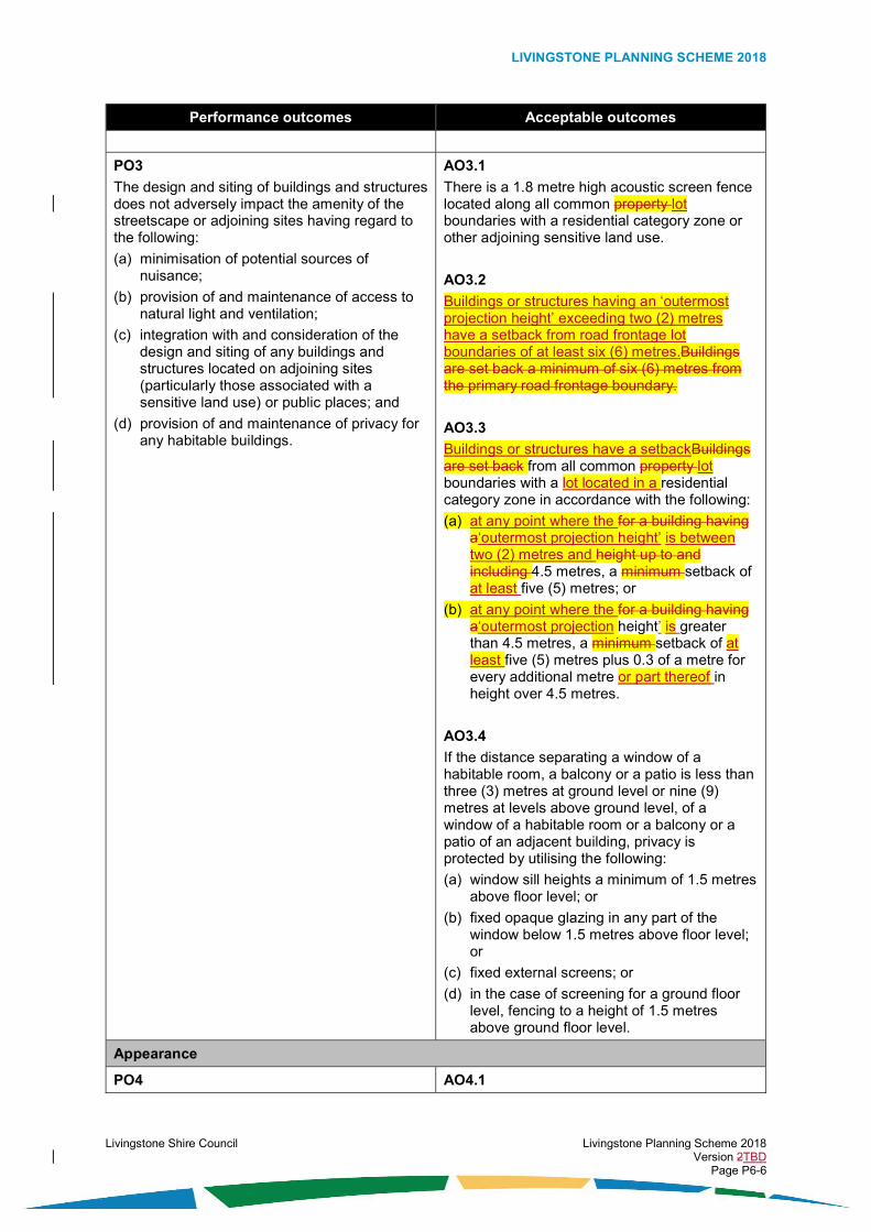
PO3
The design and siting of buildings and structures does not adversely impact the amenity of the streetscape or adjoining sites having regard to the following:
(a) minimisation of potential sources of nuisance;
(b) provision of and maintenance of access to natural light and ventilation;
(c) integration with and consideration of the design and siting of any buildings and structures located on adjoining sites (particularly those associated with a sensitive land use) or public places; and
(d) provision of and maintenance of privacy for any habitable buildings.
AO3.1
There is a 1.8 metre high acoustic screen fence located along all common property lot boundaries with a residential category zone or other adjoining sensitive land use.
AO3.2
Buildings or structures having an ‘outermost projection height’ exceeding two (2) metres have a setback from road frontage lot boundaries of at least six (6) metres.Buildings are set back a minimum of six (6) metres from the primary road frontage boundary.
AO3.3
Buildings or structures have a setbackBuildings are set back from all common property lot boundaries with a lot located in a residential category zone in accordance with the following:
(a) at any point where the for a building having a‘outermost projection height’ is between two (2) metres and height up to and including 4.5 metres, a minimum setback of at least five (5) metres; or
(b) at any point where the for a building having a‘outermost projection height’ is greater than 4.5 metres, a minimum setback of at least five (5) metres plus 0.3 of a metre for every additional metre or part thereof in height over 4.5 metres.
AO3.4
If the distance separating a window of a habitable room, a balcony or a patio is less than three (3) metres at ground level or nine (9) metres at levels above ground level, of a window of a habitable room or a balcony or a patio of an adjacent building, privacy is protected by utilising the following:
(a) window sill heights a minimum of 1.5 metres above floor level; or
(b) fixed opaque glazing in any part of the window below 1.5 metres above floor level; or
(c) fixed external screens; or
(d) in the case of screening for a ground floor level, fencing to a height of 1.5 metres above ground floor level.
Appearance
PO4 AO4.1

LIVINGSTONE PLANNING SCHEME 2018
Livingstone Shire Council Livingstone Planning Scheme 2018 Version 2TBD Page P6-7
Performance outcomes Acceptable outcomes
The development is designed in a manner that contributes to a high level of visual amenity when viewed from the street, public places, and the surrounding area by incorporating elements including but not limited to the following:
(a) emphasis on entry points;
(b) orientation to the street and any public places;
(c) use of buildings, structures or vegetation to screen any waste storage areas and building plant from view of the street;
(d) inclusion of vegetation to screen any large unarticulated building walls;
(e) inclusion of vegetation at appropriate locations to enhance public streets and places and to provide shading for pedestrian comfort.
The development has a pedestrian entry point at or visible from the primary road frontage.
AO4.2
Any waste storage areas are screened from view of the street by one or more of the following:
(a) a solid screen fence; or
(b) a wall; or
(c) dense vegetation.
AO4.3
Any building plant:
(a) is screened from view of the street by one or more of the following:
(i) a solid screen fence, or
(ii) a roof design feature; or
(iii) a wall; or
(iv) dense vegetation; or
(b) is located within, underneath or central to the building so as to not be visible from the street.
AO4.4
There is a densely vegetated area having a depth of at least five (5) metres from the property lot boundary, located along all common property lot boundaries where adjoining any residential category zone.
AO4.5
The densely vegetated area specified in AO4.4 complies with the following:
(a) there is a minimum of two (2) rounded canopy trees for every five (5) linear metres or part thereof of the length of the property lot boundary; and
(b) any established native tree species having a height exceeding two (2) metres, or a trunk diameter of thirty (30) centimetres are retained within vegetation area.
AO4.6
Where buildings are have a setback from a road frontage property lot boundary, a landscape planting bed having a minimum depth of one (1) metre is provided along the full frontage (excluding vehicle and pedestrian access ways).
AO4.7

LIVINGSTONE PLANNING SCHEME 2018
Livingstone Shire Council Livingstone Planning Scheme 2018 Version 2TBD Page P6-8
Performance outcomes Acceptable outcomes
The landscape planting bed specified in AO4.6 complies with the following:
(a) there is a minimum of two (2) rounded canopy trees for every five (5) linear metres or part thereof of the length of the road frontage property lot boundary; and
(b) there is a minimum of two (2) shrubs for every three (3) linear metres or part thereof of the length of the road frontage property lot boundary.

LIVINGSTONE PLANNING SCHEME 2018
Livingstone Shire Council Livingstone Planning Scheme 2018 Version 2TBD Page P6-9
Table 6.2.1.4.2 – Additional outcomes for assessable development
Performance outcomes Acceptable outcomes
Land use
PO5
The use:
(a) is a preferred use for the zone (as identified in the overall outcomes for the zone); or
(b) is another use that is identified in the overall outcomes for the zone and is compatible with and does not limit or compromise the development of a preferred use for the zone.
No acceptable outcome is nominated.
PO6
Each individual use within the neighbourhood centre and the neighbourhood centre as a whole:
(a) is small in scale;
(b) provides only a daily convenience function (day to day needs) serving the residents of the immediate area; and
(c) does not detract from the role and function of the higher order local, district and major centres.
AO6.1
The uses within the neighbourhood centre are small in scale, provide predominantly for convenience needs, and do not exceed the size nominated below:
Use Size (gross floor area per tenancy)
Food and drink outlet One-hundred (100) square metres
Health care services Two-hundred (200) square metres or no more than twenty (20) per cent of the gross floor area of a neighbourhood centre
Office (where not associated with another use)
One-hundred (100) square metres or no more than twenty (20) per cent of the gross floor area of a neighbourhood centre
Shop Three-hundred (300) square metres
Child care centre; or
Club; or
Community care centre; or
Community use; or
Place of worship
Indoor sport and recreation
Two-hundred (200) square metres
Service industry Fifty (50) square metres

LIVINGSTONE PLANNING SCHEME 2018
Livingstone Shire Council Livingstone Planning Scheme 2018 Version 2TBD Page P6-10
Performance outcomes Acceptable outcomes
AO6.2
An office occurs only if the total cumulative space in the neighbourhood centre for all offices does not exceed twenty (20) per cent of the total gross floor area of the neighbourhood centre.
AO6.3
A use within the community activities group occurs only if the total cumulative space in the neighbourhood centre for all community activities does not exceed twenty (20) per cent of the total gross floor area of the neighbourhood centre.
AO6.4
The neighbourhood centre as a whole is a scale that is necessary only to service a trade catchment of 1500 households.
PO7
Each individual use within the neighbourhood centre and the neighbourhood centre as a whole appropriately integrate with any established uses in the immediate area.
No acceptable outcome is nominated.
PO8
If the use is a food and drink outlet, it does not involve a drive through facility.
No acceptable outcome is nominated.
PO9
If the use is a food and drink outlet, the food and drink outlet is incorporated into the neighbourhood centre and is not a stand-alone structure.
No acceptable outcome is nominated.
Built form
PO10
Buildings are designed to: (a) fit responsibly into the streetscape;
(b) activate and engage with the street and important public spaces;
(c) create a safe pedestrian environment at street level;
(d) create interesting street level façades which avoid expanses of blank walls oriented to the street; and
(e) provide an awning over pedestrian areas, or shade trees where an awning would conflict with the streetscape (for example, heritage buildings).
AO10.1
New developments: (a) are oriented to the street and on-site
customer parking areas;
(b) at ground level, include display windows for a minimum of eighty (80) per cent of the façade area; and
(c) result in ground floor tenancies which do not exceed ten (10) metres in width, or the ground floor tenancies are punctuated at least every fifteen (15) metres by a vertical design feature or shop window displays.
AO10.2
Where fronting a street or public space, any part of a building above ground floor level includes design features, windows or balconies to at least thirty (30) per cent of the façade area of each floor level.

LIVINGSTONE PLANNING SCHEME 2018
Livingstone Shire Council Livingstone Planning Scheme 2018 Version 2TBD Page P6-11
Performance outcomes Acceptable outcomes
AO10.3
Buildings have awnings over external pedestrian footpath areas and the awnings: (a) provide continuous weather protection; (b) are not higher than 7.5 metres from the
constructed pavement or footpath to the soffit of the awning; and
(c) extend from the building over the pedestrian footpath area the greater of the following: (i) three (3) metres; or (ii) a distance which finishes 0.5 of a metre
before any roadside kerb or vehicle parking area.
AO10.4
Buildings and structures higher than 8.5 metres are set back a minimum of three (3) metres from side, rear and front boundary, and incorporate overhanging eaves, louvres and screens to maintain articulation to the street.Buildings or structures have a setback of at least three (3) metres from side, rear and road frontage lot boundaries at any point where the ‘outermost projection height’ exceeds 8.5 metres.
Appearance
PO11
Buildings have an appearance which provides visual interest and contributes to a high level of visual amenity when viewed from the street, public places, and the surrounding area by use of the following: (a) vertical and horizontal articulation to create
shadow and break up the built form by use of fenestration, recesses, wall offsets, balconies, projections, splays or other building design features;
(b) external building walls having variations in textures, materials and colours; and
(c) external building materials which are unlikely to create a nuisance, discomfort or hazard due to solar reflection.
AO11.1
Buildings have a maximum unarticulated length of fifteen (15) metres to the street frontage.
AO11.2
External building walls have at least three (3) variations, with the variations consisting of one or more of the following:
(a) changes in surface textures; or
(b) changes in materials; or
(c) changes in colours.
AO11.3
The design of the building does not include glass or surfaces that are likely to: (a) reflect solar rays for prolonged periods due
to exterior finishes and design elements, or (b) create undue nuisance, discomfort or
hazards to any part of the surrounding locality.
PO12
The roof of a building is designed in a manner that creates visual interest and can conceal any plant equipment.
No acceptable outcome is nominated.

LIVINGSTONE PLANNING SCHEME 2018
Livingstone Shire Council Livingstone Planning Scheme 2018 Version 2TBD Page P6-12
Performance outcomes Acceptable outcomes
PO13
The location of street trees, seating, waste bins, drinking fountains, public transport stops and public art and the like are: (a) provided at a scale and location appropriate
to the siting and design of the centre; (b) co-ordinated to create cohesive
streetscapes and movement areas to soften the built form and provide increased user amenity; and
(c) located so as to retain at least a 1.5 metre wide clear pedestrian zone.
No acceptable outcome is nominated.
Vehicle Parking Areas
PO14
Parking areas are designed to minimise impacts on sensitive land use due to noise, car park lighting, vehicle lighting, and loss of privacy.
No acceptable outcome is nominated.
Infrastructure
PO15
Safe, accessible, robust and reliable infrastructure relating to access and parking, energy supply, roads, roof and allotment drainage, sewage and wastewater treatment and disposal, stormwater management, telecommunications, and water supply, is adequately provided for the development in accordance with best practice and endorsed standards for the location, and relative to the needs of the development.
AO15.1
The development complies with the requirements of the Development Works Code.

LIVINGSTONE PLANNING SCHEME 2018
Livingstone Shire Council Livingstone Planning Scheme 2018 Version 2TBD Page P6-13
6.2.2. Local centre zone code
6.2.2.1. Application
This code applies to the assessment of development if it is identified as an applicable code for development, as specified in the assessment benchmarks column in the tables of assessment located in Part 5 of the planning scheme.
When using this code, reference should be made to section 5.3.2 and where applicable, section 5.3.3 located in Part 5 of the planning scheme.
All subject matter in this code is applicable to the development assessment, unless the following circumstance arises:
(1) The heading of a specific benchmarks for assessment table specifies otherwise; or
(2) A heading within a specific benchmarks for assessment table specifies that the outcomes apply to a specific type of development or to development at a specific location; or
(3) A performance outcome or acceptable outcome specifies that the outcomes apply to a specific type of development or to development at a specific location.
In the circumstance where point (2) or point (3) above arises the following applies:
(1) the development assessment outcomes apply only to the type of development specified or only to development at the location specified; and
(2) the development must still be assessed against all other general subject matter of the code (for example, assessment benchmarks including but not limited to those relating to built form, appearance, or general land use).
6.2.2.2. Purpose
The purpose of the local centre zone code is:
(1) to identify the desired character and amenity for the zone and to protect it from incompatible development;
(2) to provide for the development of highly accessible local centres which are a scale that services a local trade catchment of approximately 3000 to 5000 households;
(3) to provide for the development of the local centre of Emu Park, which is currently the only local centre in the planning scheme area;
(4) to provide for the development of local centres as places comprising a range and mixture of uses from within the centre activities group, entertainment activities group and community activities group;
(5) to provide for the development of a limited range and mixture of other uses where they are compatible with preferred uses and they support the needs of the local trade catchment area;
(6) to provide for the management of impacts on adjoining sensitive land use; and
(7) to facilitate the achievement of the overall outcomes sought for the zone.
6.2.2.3. Overall outcomes
The purpose of the code will be achieved through the following overall outcomes:
(1) the local centre operates as the third highest order centre in the planning scheme area;
(2) the local centre of Emu Park develops as a centre which:
(a) provides predominantly for the needs of local residents in terms of access to shops, health care services, food and drink outlets, a range of entertainment activities, a range of community activities and other compatible uses; and
(b) is also promoted as a tourist destination;

LIVINGSTONE PLANNING SCHEME 2018
Livingstone Shire Council Livingstone Planning Scheme 2018 Version 2TBD Page P6-14
(3) local centres develop as walkable and legible places, having a pedestrian focussed environment at ground level, with a range of connected, safe and pleasant public spaces forming community focal points;
(4) development is:
(a) a use from within the centre activities group; or
(b) a use from within the entertainment activities group; or
(c) a use from within the community activities group; or
(d) a low impact use which:
(i) is compatible with and supports a use within the centre activities group, entertainment activities group, or community activities group; or
(ii) does not limit or compromise the of a use within the centre activities group, entertainment activities group, or community activities group;
(5) the development of a use within the centre activities group is a preferred use within the zone in the following circumstances:
(a) it is an adult store; or
(b) it is a food and drink outlet; or
(c) it is health care services; or
(d) it is an office; or
(e) it is a shop; or
(f) it is a shopping centre;
(6) the development of a use within the entertainment activities group is a preferred use within the zone in the following circumstances:
(a) it is a bar; or
(b) it is a function facility; or
(c) it is a hotel; or
(d) it is a nightclub entertainment facility (only if located at the local centre of Emu Park); or
(e) it is a theatre (only if located at the local centre of Emu Park);
(7) the development of a use within the community activities group is a preferred use within the zone in the following circumstances:
(a) it is a child care centre; or
(b) it is a club; or
(c) it is a community care centre; or
(d) it is a community use; or
(e) it is an educational establishment; or
(f) it is a place of worship;
(8) the development of a use that is not within the centre activities group, entertainment activities group, or community activities group is a preferred use within the zone in the following circumstances:
(a) it has low impacts;
(b) is small in scale;
(c) it is compatible with other uses in the local centre;
(d) it is designed to integrate with development in the immediate area;
(e) the use:

LIVINGSTONE PLANNING SCHEME 2018
Livingstone Shire Council Livingstone Planning Scheme 2018 Version 2TBD Page P6-15
(i) is a caretaker’s accommodation; or
(ii) is a dwelling unit; or
(iii) is an environment facility; or
(iv) is a funeral parlour; or
(v) is a garden centre; or
(vi) is indoor sport and recreation (being a gymnasium or fitness studio); or
(vii) is a park; or
(viii) is a research and technology industry (being a computer server facility); or
(ix) is a sales office; or
(x) is a service industry; or
(xi) is from within the special activities group and it is an essential component of infrastructure servicing the community;
(9) the development of a use within the accommodation activities group (other than a caretaker’s accommodation or dwelling unit) occurs within the zone only in the following circumstance:
(a) it enhances the local centre of Emu Park as a tourist destination;
(b) it does not limit or compromise the development of preferred uses;
(c) it is designed to integrate with development in the immediate area;
(d) it is designed to complement the character of Emu Park with long-term accommodation activities located above the ground level storey;
(e) the use:
(i) is a dual occupancy; or
(ii) is rooming accommodation; or
(iii) is short-term accommodation; or
(iv) is multiple dwelling units;
(10) the development of a market or emergency services occurs only if the following circumstance:
(a) it does not limit or compromise the development of preferred uses;
(b) it is designed to integrate with development in the immediate area;
(11) the development of a use which has a medium, high, or severe impact on land use in the immediate area does not occur;
(12) development within the local centre zone does not undermine the viability, role or function of established district centres or major centres;
(13) large scale administrative and professional offices, including regional offices of government and private sector entities locate in the Yeppoon major centre and do not locate in local centres;
(14) the development is compatible with an urban form that is characterised by:
(a) low rise buildings in accordance with Figure 6.2.2.4.1.1 – Emu Park Business District Height Limits;
(b) high site cover;
(c) appealing streetscapes and public places; and
(15) in the local centre of Emu Park, views and vistas to key landmarks and local features, such as the singing ship, are retained;
(16) in the local centre of Emu Park, development is designed in a manner that is compatible with the coastal village character;

LIVINGSTONE PLANNING SCHEME 2018
Livingstone Shire Council Livingstone Planning Scheme 2018 Version 2TBD Page P6-16
(17) the appearance of development provides visual interest and contributes to a high level of visual amenity when viewed from the street, public places, and the surrounding area;
(18) development provides facilities to promote public and active transport use, and safe and equitable access to a range of transport modes; and
(19) the development is provided with adequate infrastructure and essential services.
6.2.2.4. Specific benchmarks for assessment
Table 6.2.2.4.1 — Outcomes for development that is accepted subject to requirements and assessable development
Performance outcomes Acceptable outcomes
Built form
PO1
The height and bulk of buildings and structures are consistent with the intended character of the zone and they result in the following outcomes:
(a) they do not adversely impact the character or amenity of the streetscape, adjoining sites and surrounding area;
(b) they are low to medium rise;
(c) they are human scale at street level; and
(d) they do not compromise distant views and vistas to important local landmarks (such as the singing ship) from significant public viewer places.
AO1.1
Building height and the height of The height of buildings and structures does not exceed the height limits identified for the specific locations shown on Figure 6.2.2.4.1.1 – Emu Park Business District Height Limits.
AO1.2
Site cover does not exceed the following:
(a) eighty (80) per cent if buildings have a height less than or equal to two (2) storeys; or
(b) fifty (50) per cent if buildings have a height greater than two (2) storeys.
Figure 6.2.2.4.1.1 – Emu Park Business District Height Limits

LIVINGSTONE PLANNING SCHEME 2018
Livingstone Shire Council Livingstone Planning Scheme 2018 Version 2TBD Page P6-17
Performance outcomes Acceptable outcomes
PO2 AO2.1

LIVINGSTONE PLANNING SCHEME 2018
Livingstone Shire Council Livingstone Planning Scheme 2018 Version 2TBD Page P6-18
Performance outcomes Acceptable outcomes
The design and siting of buildings and structures does not adversely impact the amenity of the streetscape or adjoining sites having regard to the following:
(a) minimisation of potential sources of nuisance;
(b) provision of and maintenance of access to natural light and ventilation;
(c) integration with and consideration of the design and siting of any buildings and structures located on adjoining sites (particularly those associated with a sensitive land use) or public places; and
(d) provision of and maintenance of privacy for any habitable buildings.
There is a 1.8 metre high acoustic screen fence located along all common property lot boundaries with a residential category zone or other adjoining sensitive land use.
AO2.2
Buildings or structures have a setback are set back from all common property lot boundaries with a lot located in a residential category zone in accordance with the following:
(a) at any point where the ‘outermost projection height’ is between two (2) metres and 4.5 metresfor a building having a height up to and including 4.5 metres, a minimum setback of at least five (5) metres; or
(b) at any point where the ‘outermost projection height’ for a building having a heightis greater than 4.5 metres, a minimum setback of at least five (5) metres plus 0.3 of a metre for every additional metre or part thereof in height over 4.5 metres.
AO2.3
Buildings are built to the road frontage lot boundary at locations identified on Figure 6.2.2.4.1.2 – Emu Park Business District Streetscape and an awning is provided over the footpath.
AO2.4
Buildings have a are setback from rear property lot boundaries a minimum of at least six (6) metres.
AO2.5
If the distance separating a window of a habitable room, a balcony or a patio is less than three (3) metres at ground level or nine (9) metres at levels above the ground level storey, of a window of a habitable room or a balcony or a patio of an adjacent building, privacy is protected by utilising the following:
(a) window sill heights a minimum of 1.5 metres above floor level; or
(b) fixed opaque glazing in any part of the window below 1.5 metres above floor level; or
(c) fixed external screens; or
(d) in the case of screening for a ground floor level, fencing to a height of 1.5 metres above ground floor level.

LIVINGSTONE PLANNING SCHEME 2018
Livingstone Shire Council Livingstone Planning Scheme 2018 Version 2TBD Page P6-19
Performance outcomes Acceptable outcomes
Figure 6.2.2.4.1.2 – Emu Park Business District Streetscape
PO3
Where multi-storey buildings are developed, the design ensures that any accommodation activities have appropriate amenity and access to natural light and ventilation.
AO3.1
For a multi-storey building, Aany part of a storeybuilding over located above the second storey, two (2) storeys in height is set back has a setback in accordance with the following:
(a) a minimum setback from road frontage lot boundaries of at leastof six (6) metres from the front boundary but no more than ten (10) metres from the front boundary; and
(b) a setback from side lot boundaries of at least one-third of the ‘outermost projection height’ of the buildingside boundary setbacks in accordance with the Queensland Development Code.
Appearance
PO4
The development is designed in a manner that contributes to a high level of visual amenity
AO4.1

LIVINGSTONE PLANNING SCHEME 2018
Livingstone Shire Council Livingstone Planning Scheme 2018 Version 2TBD Page P6-20
Performance outcomes Acceptable outcomes
when viewed from the street, public places, and the surrounding area by incorporating elements including but not limited to the following:
(a) emphasis on entry points;
(b) orientation to the street and any public places;
(c) use of buildings, structures or vegetation to screen any waste storage areas and building plant from view of the street;
(d) inclusion of vegetation to screen any large unarticulated building walls;
(e) inclusion of vegetation at appropriate locations to enhance public streets and places and to provide shading for pedestrian comfort.
The development has a pedestrian entry point at or visible from the primary road frontage.
AO4.2
Any waste storage areas are screened from view of the street by one or more of the following:
(a) a solid screen fence; or
(b) a wall; or
(c) dense vegetation.
AO4.3
Any building plant:
(a) is screened from view of the street by one or more of the following:
(i) a solid screen fence, or
(ii) a roof design feature; or
(iii) a wall; or
(iv) dense vegetation; or
(b) is located within, underneath or central to the building so as to not be visible from the street.
AO4.4
There is a densely vegetated area having a depth of at least five (5) metres from the property lot boundary, located along all common property lot boundaries where adjoining any residential category zone.
AO4.5
The densely vegetated area specified in AO4.4 complies with the following:
(a) there is a minimum of two (2) rounded canopy trees for every five (5) linear metres or part thereof of the length of the property lot boundary; and
(b) any established native tree species having a height exceeding two (2) metres, or a trunk diameter of thirty (30) centimetres are retained within vegetation area.
Table 6.2.2.4.2 – Additional outcomes for assessable development
Performance outcomes Acceptable outcomes
Land use
PO5
The use:
(a) is a preferred use for the zone (as identified in the overall outcomes for the zone); or
No acceptable outcome is nominated.

LIVINGSTONE PLANNING SCHEME 2018
Livingstone Shire Council Livingstone Planning Scheme 2018 Version 2TBD Page P6-21
Performance outcomes Acceptable outcomes
(b) is another use that is identified in the overall outcomes for the zone and is compatible with and does not limit or compromise the development of a preferred use for the zone.
PO6
The use does not undermine the viability, role or function of a district centre or a major centre in the planning scheme centres hierarchy.
No acceptable outcome is nominated.
PO7
The use appropriately integrates with any established uses in the immediate area.
No acceptable outcome is nominated.
PO8
The use does not result in medium impacts, high impacts, or extreme impacts and risks due to emissions, or dangerous or hazardous goods and activities.
No acceptable outcome is nominated.
PO9
The use is located, designed and operated in a manner that maintains public safety and minimises impacts on other land use.
No acceptable outcome is nominated.
PO10
If the use is a food and drink outlet, it does not involve a drive through facility.
No acceptable outcome is nominated.
PO11
The development of a public use that generates frequent and a large amount of public visitation:
(a) is highly accessible; and
(b) is well located in relation to public and active transport networks.
No acceptable outcome is nominated.
Built form
PO12
Development is designed to: (a) fit responsibly into the streetscape;
(b) activate and engage with the street and important public spaces;
(c) create a pedestrian rather than car oriented street frontage;
(d) create a safe pedestrian environment at street level;
(e) create interesting street level façades which avoid expanses of blank walls oriented to the street;
(f) provide an awning over pedestrian areas or shade trees where an awning would conflict with the streetscape (for example, heritage buildings).
AO12.1
New developments: (a) are oriented to the street and on-site
customer parking areas;
(b) at ground level, include display windows for a minimum of eighty (80) per cent of the façade area; and
(c) result in ground floor tenancies which do not exceed ten (10) metres in width, or the ground floor tenancies are punctuated at least every fifteen (15) metres by a vertical design feature or shop window displays.
AO12.2
Where fronting a street or public space, any part of a building above ground floor level includes design features, windows or balconies to at least thirty (30) per cent of the façade area of each floor level.

LIVINGSTONE PLANNING SCHEME 2018
Livingstone Shire Council Livingstone Planning Scheme 2018 Version 2TBD Page P6-22
Performance outcomes Acceptable outcomes
AO12.3
Buildings have awnings over external pedestrian footpath areas and the awnings: (a) provide continuous weather protection; (b) are not higher than 7.5 metres from the
constructed pavement or footpath to the soffit of the awning; and
(c) extend from the building over the pedestrian footpath area the greater of the following: (i) three (3) metres; or (ii) a distance which finishes 0.5 of a metre
before any roadside kerb or vehicle parking area.
Note: The following figure illustrates the desired outcome.
PO13
Ground level streetscapes are developed with uses which create daytime and night time activity.
AO13.1
The development of a long-term accommodation activity occurs only above the ground level storey.
AO13.2
Active uses are provided on the ground level of all buildings identified as built to boundary buildings on Figure 6.2.2.4.1.2 – Emu Park Business District Streetscape.
PO14
All buildings provide opportunities for ground floor reuse and adaptation for alternative preferred uses.
AO14.1
Building ground floors have a floor to ceiling height of at least four (4) metres.
Appearance
PO15
Buildings have an appearance which provides visual interest and contributes to a high level of visual amenity when viewed from the street, public places, and the surrounding area by use of the following: (a) vertical and horizontal articulation to create
shadow and break up the built form by use of fenestration, recesses, wall offsets,
AO15.1
Buildings have a maximum unarticulated length of fifteen (15) metres to the street frontage.
AO15.2
External building walls have at least three (3) variations, with the variations consisting of one or more of the following:
(a) changes in surface textures; or

LIVINGSTONE PLANNING SCHEME 2018
Livingstone Shire Council Livingstone Planning Scheme 2018 Version 2TBD Page P6-23
Performance outcomes Acceptable outcomes
balconies, projections, splays or other building design features;
(b) external building walls having variations in textures, materials and colours;
(c) external building materials which are unlikely to create a nuisance, discomfort or hazard due to solar reflection.
(b) changes in materials; or
(c) changes in colours.
AO15.3
The design of the building does not include glass or surfaces that are likely to: (a) reflect solar rays for prolonged periods due
to exterior finishes and design elements, or (b) create undue nuisance, discomfort or
hazards to any part of the surrounding locality.
PO16
Buildings are well designed and decorated to respond to the sub-tropical climate and the coastal town character of the immediate area.
No acceptable outcome is nominated.
PO17
The roof of a building is designed in a manner that creates visual interest and can conceal any plant equipment.
No acceptable outcome is nominated.
PO18
The location of street trees, seating, waste bins, drinking fountains, public transport stops and public art and the like are: (a) provided at a scale and location appropriate
to the siting and design of the centre;
(b) co-ordinated to create cohesive streetscapes and movement areas to soften the built form and provide increased user amenity; and
(c) located so as to retain at least a 1.5 metre wide clear pedestrian zone.
No acceptable outcome is nominated.
Vehicle parking areas and access
PO19
Parking areas are designed to minimise impacts on sensitive land use due to noise, car park lighting, vehicle lighting, and loss of privacy.
No acceptable outcome is nominated.
PO20
On-site vehicle parking areas do not compromise the walkability and active shop front focus of the streetscape and they are sited:
(a) to the side or the rear of buildings; or
(b) below ground level.
No acceptable outcome is nominated.
PO21
Access to sites is via existing crossovers and new crossovers do not interrupt the walkability of key pedestrian areas unnecessarily.
AO21.1
In the local centre of Emu Park, no new vehicle accesses are provided to Hill Street.
Infrastructure
PO22 AO22.1

LIVINGSTONE PLANNING SCHEME 2018
Livingstone Shire Council Livingstone Planning Scheme 2018 Version 2TBD Page P6-24
Performance outcomes Acceptable outcomes
Safe, accessible, robust and reliable infrastructure relating to access and parking, energy supply, roads, roof and allotment drainage, sewage and wastewater treatment and disposal, stormwater management, telecommunications, and water supply, is adequately provided for the development in accordance with best practice and endorsed standards for the location, and relative to the needs of the development.
The development complies with the requirements of the Development Works Code.

LIVINGSTONE PLANNING SCHEME 2018
Livingstone Shire Council Livingstone Planning Scheme 2018 Version 2TBD Page P6-25
6.2.3. District centre zone code
6.2.3.1. Application
This code applies to the assessment of development if it is identified as an applicable code for development, as specified in the assessment benchmarks column in the tables of assessment located in Part 5 of the planning scheme.
When using this code, reference should be made to section 5.3.2 and where applicable, section 5.3.3 located in Part 5 of the planning scheme.
All subject matter in this code is applicable to the development assessment, unless the following circumstance arises:
(1) The heading of a specific benchmarks for assessment table specifies otherwise; or
(2) A heading within a specific benchamrks for assessment table specifies that the outcomes apply to a specific type of development or to development at a specific location; or
(3) A performance outcome or acceptable outcome specifies that the outcomes apply to a specific type of development or to development at a specific location.
In the circumstance where point (2) or point (3) above arises the following applies:
(1) the development assessment outcomes apply only to the type of development specified or only to development at the location specified; and
(2) the development must still be assessed against all other general subject matter of the code (for example, assessment benchmarks including but not limited to those relating to built form, appearance, or general land use).
6.2.3.2. Purpose
The purpose of the district centre zone code is:
(1) to identify the desired character and amenity for the zone and to protect it from incompatible development;
(2) to provide for the development of highly accessible district centres which are a scale that services a trade catchment of approximately 5000 to 8000 households;
(3) to provide for the development of district centres as places comprising a range and mixture of uses from within the centre activities group, entertainment activities group and community activities group;
(4) to provide for the development of a range and mixture of other uses where they are compatible with preferred uses and they support the needs of the trade catchment area;
(5) to provide for the management of impacts on adjoining sensitive land use; and
(6) to facilitate the achievement of the overall outcomes sought for the zone.
6.2.3.3. Overall outcomes
The purpose of the code will be achieved through the following overall outcomes:
(1) the district centre operates as the second highest order centre in the planning scheme area;
(2) district centres develop as walkable and legible places, having a pedestrian focussed environment at ground level, with a range of connected, safe and pleasant public spaces forming community focal points;
(3) the district centre provides predominantly for the needs of residents of a large trade catchment area in terms of access to shops, health care services, food and drink outlets, a range of entertainment activities, a range of community activities and other compatible uses;
(4) development is:
(a) a use from within the centre activities group; or
(b) a use from within the entertainment activities group; or

LIVINGSTONE PLANNING SCHEME 2018
Livingstone Shire Council Livingstone Planning Scheme 2018 Version 2TBD Page P6-26
(c) a use from within the community activities group; or
(d) a low impact use which:
(i) is compatible with and supports a use within the centre activities group, entertainment activities group, or community activities group; or
(ii) does not limit or compromise the of a use within the centre activities group, entertainment activities group, or community activities group;
(5) the development of a use within the centre activities group is a preferred use within the zone in the following circumstances:
(a) it is an adult store; or
(b) it is a food and drink outlet; or
(c) it is health care services; or
(d) it is an office; or
(e) it is a shop; or
(f) it is a shopping centre;
(6) the development of a use within the entertainment activities group is a preferred use within the zone in the following circumstances:
(a) it is a bar; or
(b) it is a function facility; or
(c) it is a hotel; or
(d) it is a nightclub entertainment facility; or
(e) it is a theatre;
(7) the development of a use within the community activities group is a preferred use within the zone in the following circumstances:
(a) it is a child care centre; or
(b) it is a club; or
(c) it is a community care centre; or
(d) it is a community use; or
(e) it is an educational establishment; or
(f) it is a place of worship;
(8) the development of a use that is not within the centre activities group, entertainment activities group, or community activities group is a preferred use within the zone in the following circumstances:
(a) it is compatible with other uses in the centre;
(b) it is designed to integrate with development in the immediate area;
(c) the use:
(i) is a caretaker’s accommodation; or
(ii) is a dwelling unit; or
(iii) is an environment facility; or
(iv) is a funeral parlour; or
(v) is a garden centre; or
(vi) is indoor sport and recreation; or
(vii) is a park; or
(viii) is a research and technology industry (being a computer server facility); or

LIVINGSTONE PLANNING SCHEME 2018
Livingstone Shire Council Livingstone Planning Scheme 2018 Version 2TBD Page P6-27
(ix) is a sales office; or
(x) is a service industry; or
(xi) is from within the special activities group and it is an essential component of infrastructure servicing the community;
(9) the development of a use within the accommodation activities group (other than a caretaker’s accommodation or dwelling unit) occurs within the zone only in the following circumstance:
(a) it does not limit or compromise the development of preferred uses;
(b) it is designed to integrate with development in the immediate area;
(c) it is designed to complement the character of the location;
(d) long-term accommodation activities are located above the ground level storey;
(e) the use:
(i) is a dual occupancy; or
(ii) is rooming accommodation; or
(iii) is short-term accommodation; or
(iv) is multiple dwelling units;
(10) the development of a market or emergency services occurs only if the following circumstance:
(a) it does not limit or compromise the development of preferred uses;
(b) it is designed to integrate with development in the immediate area;
(11) the development of a use which has a medium, high, or severe impact on land use in the immediate area does not occur;
(12) development within the district centre zone does not undermine the viability, role or function of established major centres;
(13) the Emu Park district centre only establishes once the population of the catchment area is sufficient to support a centre of this scale without compromising the viability of the historic local centre of Emu Park;
(14) large scale administrative and professional offices, including regional offices of government and private sector entities locate in the Yeppoon major centre and do not locate in district centres;
(15) the development is compatible with an urban form that is characterised by:
(a) buildings that do not exceed three (3) storeys above ground level;
(b) high site cover;
(c) appealing streetscapes and public places; and
(16) the appearance of development provides visual interest and contributes to a high level of visual amenity when viewed from the street, public places, and the surrounding area;
(17) development provides facilities to promote public and active transport use, and safe and equitable access to a range of transport modes; and
(18) the development is provided with adequate infrastructure and essential services.
6.2.3.4. Specific benchmarks for assessment
Table 6.2.3.4.1 — Outcomes for development that is accepted subject to requirements and assessable development
Performance outcomes Acceptable outcomes
Built form
PO1 AO1.1

LIVINGSTONE PLANNING SCHEME 2018
Livingstone Shire Council Livingstone Planning Scheme 2018 Version 2TBD Page P6-28
Performance outcomes Acceptable outcomes
The height and bulk of buildings and structures are consistent with the intended character of the zone and they result in the following outcomes:
(a) they do not adversely impact the character or amenity of the streetscape, adjoining sites and surrounding area;
(b) they are low rise; and
(c) they are human scale at street level.
Building height and the height of The height of buildings and structures does not exceed three (3) storeys.
AO1.2
Site cover does not exceed eighty (80) per cent.
PO2
The design and siting of buildings and structures does not adversely impact the amenity of the streetscape or adjoining sites having regard to the following:
(a) minimisation of potential sources of nuisance;
(b) provision of and maintenance of access to natural light and ventilation;
(c) integration with and consideration of the design and siting of any buildings and structures located on adjoining sites (particularly those associated with a sensitive land use) or public places; and
(d) provision of and maintenance of privacy for any habitable buildings.
AO2.1
There is a 1.8 metre high acoustic screen fence located along all common property lot boundaries with a residential category zone or other adjoining sensitive land use.
AO2.2
Buildings or structures have a setbackare set back from all common property lot boundaries with a lot located in a residential category zone in accordance with the following:
(a) at any point where for a building having athe ‘outermost projection height’ is between two (2) metres andup to and including 4.5 metres, a minimum setback of at least five (5) metres; or
(b) at any point where the for a building having a ‘outermost projection height’ is greater than 4.5 metres, a minimum setback of at least five (5) metres plus 0.3 of a metre for every additional metre or part thereof in height over 4.5 metres.
AO2.3
Buildings have a minimum boundary setback of at least six (6) metres from lot boundaries.
AO2.4
If the distance separating a window of a habitable room, a balcony or a patio is less than three (3) metres at ground level or nine (9) metres at levels above the ground level storey, of a window of a habitable room or a balcony or a patio of an adjacent building, privacy is protected by utilising the following:
(a) window sill heights a minimum of 1.5 metres above floor level; or
(b) fixed opaque glazing in any part of the window below 1.5 metres above floor level; or
(c) fixed external screens; or
(d) in the case of screening for a ground floor level, fencing to a height of 1.5 metres above ground floor level.

LIVINGSTONE PLANNING SCHEME 2018
Livingstone Shire Council Livingstone Planning Scheme 2018 Version 2TBD Page P6-29
Performance outcomes Acceptable outcomes
Appearance
PO3
The development is designed in a manner that contributes to a high level of visual amenity when viewed from the street, public places, and the surrounding area by incorporating elements including but not limited to the following:
(a) emphasis on entry points;
(b) orientation to the street and any public places;
(c) use of buildings, structures or vegetation to screen any waste storage areas and building plant from view of the street;
(d) inclusion of vegetation to soften the visual impact of any large unarticulated building walls when viewed from residential category zones and scenic transport routes;
(e) inclusion of vegetation between buildings and property lot boundaries that adjoin major transport routes; and
(f) inclusion of vegetation at appropriate locations to enhance public streets and places and to provide shading for pedestrian comfort.
AO3.1
The development has a pedestrian entry point at or visible from the primary road frontage.
AO3.2
Any waste storage areas are screened from view of the street by one or more of the following:
(a) a solid screen fence; or
(b) a wall; or
(c) dense vegetation.
AO3.3
Any building plant:
(a) is screened from view of the street by one or more of the following:
(i) a solid screen fence, or
(ii) a roof design feature; or
(iii) a wall; or
(iv) dense vegetation; or
(b) is located within, underneath or central to the building so as to not be visible from the street.
AO3.4
There is a densely vegetated area having a depth of at least five (5) metres from the property lot boundary, located along all common property lot boundaries where adjoining any residential category zone.
AO3.5
There is a densely vegetated area having a depth of at least five (5) metres from the property lot boundary, located along all property lot boundaries which adjoin an identified scenic transport route on an overlay map.
AO3.6
The densely vegetated areas specified in AO3.4 and AO3.5 comply with the following:
(a) there is a minimum of two (2) rounded canopy trees for every five (5) linear metres or part thereof of the length of the road frontage property lot boundary; and
(b) there is a minimum of two (2) shrubs for every three (3) linear metres or part thereof of the length of the road frontage property lot boundary; and

LIVINGSTONE PLANNING SCHEME 2018
Livingstone Shire Council Livingstone Planning Scheme 2018 Version 2TBD Page P6-30
Performance outcomes Acceptable outcomes
(c) any established native tree species having a height exceeding two (2) metres, or a trunk diameter of thirty (30) centimetres are retained within vegetation area.
AO3.7
Where buildings are setback from a road frontage property lot boundary, a landscape planting bed having a minimum depth of one two (2) metres from the property lot boundary, is located along all road frontage boundaries (other than a boundary adjoining an identified scenic transport route on an overlay map), excluding the access driveway.
AO3.8
The vegetated area specified in AO3.7 complies with the following:
(a) there is a minimum of two (2) rounded canopy trees for every five (5) linear metres or part thereof of the length of the road frontage property lot boundary; and
(b) there is a minimum of two (2) shrubs for every three (3) linear metres or part thereof of the length of the road frontage property lot boundary; and
(c) any established native tree species having a height exceeding two (2) metres, or a trunk diameter of thirty (30) centimetres are retained within vegetation area.
Table 6.2.3.4.2 – Additional outcomes for assessable development
Performance outcomes Acceptable outcomes
Land use
PO4
The use:
(a) is a preferred use for the zone (as identified in the overall outcomes for the zone); or
(b) is another use that is identified in the overall outcomes for the zone and is compatible with and does not limit or compromise the development of a preferred use for the zone.
No acceptable outcome is nominated.
PO5
The use does not undermine the viability, role or function of a major centre in the planning scheme centres hierarchy.
No acceptable outcome is nominated.
PO6
The Emu Park district centre only establishes once the population of the catchment area is sufficient to support a centre of this scale
No acceptable outcome is nominated.

LIVINGSTONE PLANNING SCHEME 2018
Livingstone Shire Council Livingstone Planning Scheme 2018 Version 2TBD Page P6-31
Performance outcomes Acceptable outcomes
without compromising the viability of the historic local centre of Emu Park.
PO7
The use appropriately integrates with any established uses in the immediate area.
No acceptable outcome is nominated.
PO8
The use does not result in medium impacts, high impacts, or extreme impacts and risks due to emissions, or dangerous or hazardous goods and activities.
No acceptable outcome is nominated.
PO9
The use is located, designed and operated in a manner that maintains public safety and minimises impacts on other land use.
No acceptable outcome is nominated.
PO10
The development of a public use that generates frequent and a large amount of public visitation:
(a) is highly accessible; and
(b) is well located in relation to public and active transport networks.
No acceptable outcome is nominated.
Built form
PO11
Development is designed to: (a) fit responsibly into the streetscape reflecting
the character expected in the locality in which the centre is located;
(b) activate and engage with the street and important public spaces;
(c) create a pedestrian rather than car oriented street frontage;
(d) create a safe pedestrian environment at street level;
(e) create interesting street level façades which avoid expanses of blank walls oriented to the street;
(f) provide opportunities to accommodate a range of preferred uses; and
(g) provide an awning over pedestrian areas or shade trees where an awning would conflict with the streetscape (for example, heritage buildings).
AO11.1
New developments: (a) are oriented to the street and on-site
customer parking areas;
(b) where practicable at ground level, include display windows for a minimum of eighty (80) per cent of the façade area; and
(c) where practicable, result in ground floor tenancies which do not exceed ten (10) metres in width, or the ground floor tenancies are punctuated at least every fifteen (15) metres by a vertical design feature or shop window displays.
AO11.2
Where fronting a street or public space, any part of a building above ground floor level includes design features, windows or balconies to at least thirty (30) per cent of the façade area of each floor level.
AO11.3
Buildings have awnings over external pedestrian footpath areas and the awnings: (a) provide continuous weather protection; (b) are not higher than 7.5 metres from the
constructed pavement or footpath to the soffit of the awning; and

LIVINGSTONE PLANNING SCHEME 2018
Livingstone Shire Council Livingstone Planning Scheme 2018 Version 2TBD Page P6-32
Performance outcomes Acceptable outcomes
(c) extend from the building over the pedestrian footpath area the greater of the following: (i) three (3) metres; or (ii) a distance which finishes 0.5 of a metre
before any roadside kerb or vehicle parking area.
PO12
Where practicable, ground level streetscapes are developed with uses which create daytime and night time activity.
AO12.1
The development of a long-term accommodation activity occurs only above the ground level storey.
Appearance
PO13
Buildings have an appearance which provides visual interest and contributes to a high level of visual amenity when viewed from the street, public places, and the surrounding area by use of the following: (a) vertical and horizontal articulation to create
shadow and break up the built form by use of fenestration, recesses, wall offsets, balconies, projections, splays or other building design features;
(b) external building walls having variations in textures, materials and colours; and
(c) external building materials which are unlikely to create a nuisance, discomfort or hazard due to solar reflection.
AO13.1
Buildings have a maximum unarticulated length of fifteen (15) metres to the street frontage.
AO13.2
External building walls have at least three (3) variations, with the variations consisting of one or more of the following:
(a) changes in surface textures; or
(b) changes in materials; or
(c) changes in colours.
AO13.3
The design of the building does not include glass or surfaces that are likely to: (a) reflect solar rays for prolonged periods due
to exterior finishes and design elements; or (b) create undue nuisance, discomfort or
hazards to any part of the surrounding locality.
PO14
Buildings are well designed to respond to the sub-tropical climate of the area.
No acceptable outcome is nominated.
PO15
The roof of a building is designed in a manner that creates visual interest and can conceal any plant equipment.
No acceptable outcome is nominated.
PO16
The location of street trees, seating, waste bins, drinking fountains, public transport stops and public art and the like are: (a) provided at a scale and location appropriate
to the siting and design of the centre;
(b) co-ordinated to create cohesive streetscapes and movement areas to soften the built form and provide increased user amenity; and
No acceptable outcome is nominated.

LIVINGSTONE PLANNING SCHEME 2018
Livingstone Shire Council Livingstone Planning Scheme 2018 Version 2TBD Page P6-33
Performance outcomes Acceptable outcomes
(c) located so as to retain at least a 1.5 metre wide clear pedestrian zone.
Vehicle Parking Areas
PO17
Parking areas are designed to minimise impacts on sensitive land use due to noise, car park lighting, vehicle lighting, and loss of privacy.
No acceptable outcome is nominated.
PO18
On-site vehicle parking areas do not compromise the walkability and active shop front focus of the streetscape and they are sited:
(a) to the side or the rear of buildings; or
(b) below ground level.
No acceptable outcome is nominated.
Infrastructure
PO19
Safe, accessible, robust and reliable infrastructure relating to access and parking, energy supply, roads, roof and allotment drainage, sewage and wastewater treatment and disposal, stormwater management, telecommunications, and water supply, is adequately provided for the development in accordance with best practice and endorsed standards for the location, and relative to the needs of the development.
AO19.1
The development complies with the requirements of the Development Works Code.

LIVINGSTONE PLANNING SCHEME 2018
Livingstone Shire Council Livingstone Planning Scheme 2018 Version 2TBD Page P6-34
6.2.4. Major centre zone code
6.2.4.1. Application
This code applies to the assessment of development if it is identified as an applicable code for development, as specified in the assessment benchmarks column in the tables of assessment located in Part 5 of the planning scheme.
When using this code, reference should be made to section 5.3.2 and where applicable, section 5.3.3 located in Part 5 of the planning scheme.
All subject matter in this code is applicable to the development assessment, unless the following circumstance arises:
(1) The heading of a specific benchmarks for assessment table specifies otherwise; or
(2) A heading within a specific benchmarks for assessment table specifies that the outcomes apply to a specific type of development or to development at a specific location; or
(3) A performance outcome or acceptable outcome specifies that the outcomes apply to a specific type of development or to development at a specific location.
In the circumstance where point (2) or point (3) above arises the following applies:
(1) the development assessment outcomes apply only to the type of development specified or only to development at the location specified; and
(2) the development must still be assessed against all other general subject matter of the code (for example, assessment benchmarks including but not limited to those relating to built form, appearance, or general land use).
6.2.4.2. Purpose
The purpose of the major centre zone code is:
(1) to identify the desired character and amenity for the zone and to protect it from incompatible development;
(2) to provide for the development of the major centre of Yeppoon which:
(a) is the highest order centre in the planning scheme area; and
(b) is a scale that services a large trade catchment in excess of 8000 households;
(3) to provide opportunities for the major centre of Yeppoon to evolve as a lively, mixed-use community hub;
(4) to provide for the development of the major centre of Yeppoon as a place comprising the largest range and mixture of uses from within the centre activities group, entertainment activities group and community activities group;
(5) to provide for the development of a range and mixture of other uses where they are compatible with preferred uses and they support the needs of the trade catchment area;
(6) to provide for the management of impacts on adjoining sensitive land use; and
(7) to facilitate the achievement of the overall outcomes sought for the zone.
6.2.4.3. Overall outcomes
The purpose of the code will be achieved through the following overall outcomes:
(1) the major centre of Yeppoon operates as the primary, multifunctional centre in the planning scheme area, which accommodates the highest order retail, commercial, administrative, health, community, civic, cultural, entertainment and accommodation uses;
(2) sufficient land is included in the zone to accommodate the projected retail and commercial needs for the life of the planning scheme, including land for additional shopping and mixed use development at the western end of James Street, and re-development and infill opportunities on smaller sites;

LIVINGSTONE PLANNING SCHEME 2018
Livingstone Shire Council Livingstone Planning Scheme 2018 Version 2TBD Page P6-35
(3) the major centre of Yeppoon develops as walkable and legible place, having a pedestrian focussed environment at ground level, with a range of connected, safe and pleasant public spaces forming community focal points;
(4) development is:
(a) a use from within the centre activities group; or
(b) a use from within the entertainment activities group; or
(c) a use from within the community activities group; or
(d) a low impact use which:
(i) is compatible with and supports a use within the centre activities group, entertainment activities group, or community activities group; or
(ii) does not limit or compromise the of a use within the centre activities group, entertainment activities group, or community activities group;
(5) the development of a use from within the centre activities group is a preferred use within the zone in the following circumstances:
(a) it is an adult store; or
(b) it is a food and drink outlet; or
(c) it is health care services; or
(d) it is an office; or
(e) it is a shop; or
(f) it is a shopping centre;
(6) the development of a use from within the entertainment activities group is a preferred use within the zone in the following circumstances:
(a) it is a bar; or
(b) it is a function facility; or
(c) it is a hotel; or
(d) it is a nightclub entertainment facility; or
(e) it is a theatre;
(7) the development of a use from within the community activities group is a preferred use within the zone in the following circumstances:
(a) it is a child care centre; or
(b) it is a club; or
(c) it is a community care centre; or
(d) it is a community use; or
(e) it is an educational establishment; or
(f) it is a place of worship;
(8) the development of a use that is not from within the centre activities group, entertainment activities group, or community activities group is a preferred use within the zone in the following circumstances:
(a) it has low impacts;
(b) it is compatible with other uses in the centre;
(c) it is designed to integrate with development in the immediate area;
(d) the use:
(i) is a caretaker’s accommodation; or
(ii) is a dwelling unit; or

LIVINGSTONE PLANNING SCHEME 2018
Livingstone Shire Council Livingstone Planning Scheme 2018 Version 2TBD Page P6-36
(iii) is an environment facility; or
(iv) is a funeral parlour; or
(v) is a garden centre; or
(vi) is indoor sport and recreation (being a gymnasium or fitness studio); or
(vii) is a park; or
(viii) is a research and technology industry (being a computer server facility); or
(ix) is a sales office; or
(x) is a service industry; or
(xi) is from within the special activities group and it is an essential component of infrastructure servicing the community;
(9) the development of a use from within the accommodation activities group (other than a caretaker’s accommodation or dwelling unit) occurs within the zone only in the following circumstance:
(a) it does not limit or compromise the development of preferred uses;
(b) it is designed to integrate with development in the immediate area;
(c) it is designed to complement the character of the location;
(d) the development is located above the ground level storey;
(e) the use:
(i) is a dual occupancy; or
(ii) is rooming accommodation; or
(iii) is short-term accommodation; or
(iv) is multiple dwelling units;
(10) the development of a market or emergency services occurs only if the following circumstance:
(a) it does not limit or compromise the development of preferred uses;
(b) it is designed to integrate with development in the immediate area;
(11) large format shops, showrooms and warehouses are not located in the Yeppoon major centre;
(12) the development of a use which has a medium, high, or severe impact on land use in the immediate area does not occur;
(13) the development is compatible with an urban form that is characterised by:
(a) the height of buildings and structures above ground level does not exceed the height limits identified for the specific locations shown on Figure 6.2.4.4.1.1 – Yeppoon Business District Height Limits and Figure 6.2.4.4.1.2 – Yeppoon Central Shopping Centre Height Limits;
(b) high site cover;
(c) incorporation of podium and tower designs for taller buildings;
(d) orientation of development to important streets and important public focal points such as the foreshore, Beaman Park, and the town square at the junction of James and Normanby Streets;
(e) building designs which accommodate a range of uses;
(f) appealing streetscapes and public places;
(14) the major centre of Yeppoon is characterised by a traditional ‘main street’ feel and the design of development maintains this by contributing to the following:
(a) buildings having active uses in lower levels which face streets and other public places;

LIVINGSTONE PLANNING SCHEME 2018
Livingstone Shire Council Livingstone Planning Scheme 2018 Version 2TBD Page P6-37
(b) buildings having accommodation activities locate the accommodation predominantly above ground level and the accommodation is able to provide surveillance to public places;
(c) high quality streetscapes with landscaping suited to a coastal location;
(d) utilisation of laneways; and
(e) pedestrian friendly footpaths covered by awnings;
(15) new development on the former railway site located on the northern side of James Street only occurs in accordance with the following:
(a) development on this site contributes to the strengthening of the ‘main street’ character of the centre, by orientating uses to existing streets or any new streets, laneways or internal pedestrian footpaths;
(b) internally focussed ‘big-box’ development does not occur; and
(c) development on this site is appropriately integrated with historic buildings and structures;
(16) development provides on-site car parking for staff and any accommodation activities, with the parking areas located to the rear of buildings and if practicable gaining access from a laneway;
(17) the major centre of Yeppoon provides opportunities for off-site vehicle parking in appropriate circumstances;
(18) development provides facilities to promote public and active transport use, and safe and equitable access to a range of transport modes;
(19) the appearance of development provides visual interest and contributes to a high level of visual amenity when viewed from the street, public places, and the surrounding area; and
(20) the development is provided with adequate infrastructure and essential services.
6.2.4.4. Specific benchmarks for assessment
Table 6.2.4.4.1 — Outcomes for development that is accepted subject to requirements and assessable development
Performance outcomes Acceptable outcomes
Land use
PO1
The use:
(a) is a preferred use for the zone (as identified in the overall outcomes for the zone); or
(b) is a use that is identified in the overall outcomes for the zone and is compatible with and does not limit or compromise the development of a preferred use for the zone.
No acceptable outcome is nominated.
PO2
The use reinforces and contributes to the viability, role and function of the major centre of Yeppoon as the highest order centre in the planning scheme area.
No acceptable outcome is nominated.
PO3
Large format shops, showrooms and warehouses are not located in the Yeppoon major centre.
No acceptable outcome is nominated.
PO4
Ground level streetscapes are developed with uses which create daytime and night time activity.
AO4.1
The development of a long-term accommodation activity occurs only above the ground level storey.

LIVINGSTONE PLANNING SCHEME 2018
Livingstone Shire Council Livingstone Planning Scheme 2018 Version 2TBD Page P6-38
Performance outcomes Acceptable outcomes
AO4.2
Active uses are provided on the ground level of all buildings identified as built to boundary buildings on Figure 6.2.4.4.1.3 – Yeppoon Business District Streetscape.
PO5
The use appropriately integrates with any established uses in the immediate area.
No acceptable outcome is nominated.
PO6
The use does not result in medium impacts, high impacts, or extreme impacts and risks due to emissions, or dangerous or hazardous goods and activities.
No acceptable outcome is nominated.
PO7
The use is located, designed and operated in a manner that maintains public safety and minimises impacts on other land use.
No acceptable outcome is nominated.
PO8
If the use adjoins a residential category zone, it does not involve a drive through facility.
No acceptable outcome is nominated.
PO9
The development of a public use that generates frequent and a large amount of public visitation:
(a) is highly accessible; and
(b) is well located in relation to public and active transport networks.
No acceptable outcome is nominated.
PO10
Development at the former Yeppoon Station and rail yards site (Lot 3 SP 254313): (a) accommodates a range of centre activities
and compatible accommodation activities;
(b) incorporates distinctive open spaces;
(c) includes ’main street’ design features to James Street and Arthur Street.
AO10.1
Development at the former Yeppoon Station and rail yards site (Lot 3 SP254313) comprises a mix of uses at street level including retail, food and drink outlets, cultural, entertainment and community activities with appropriate accommodation activities located above the ground level storey.
Built form
PO11
The height and bulk of buildings and structures contribute to the following:
(a) a consolidated town centre containing medium rise buildings;
(b) continuous and integrated streetscapes having buildings of similar height;
(c) a human scale at street level with activated streets and safe and comfortable pedestrian circulation; and
(d) retention of distant views and vistas to important local landscape features when viewed from primary public viewer places.
AO11.1
Building height and the height of The height of buildings and structures does not exceed the height limits identified for the specific locations shown on Figure 6.2.4.4.1.1 – Yeppoon Business District Height Limits and Figure 6.2.4.4.1.2 – Yeppoon Central Shopping Centre Height Limits.
AO11.2
Site cover does not exceed the following:
(a) eighty (80) per cent for buildings up to and including three (3) storeys in height;

LIVINGSTONE PLANNING SCHEME 2018
Livingstone Shire Council Livingstone Planning Scheme 2018 Version 2TBD Page P6-39
Performance outcomes Acceptable outcomes
(b) fifty (50) per cent for buildings greater than three (3) storeys in height.
Figure 6.2.4.4.1.1 – Yeppoon Business District Height Limits
Figure 6.2.4.4.1.2 – Yeppoon Central Shopping Centre Height Limits
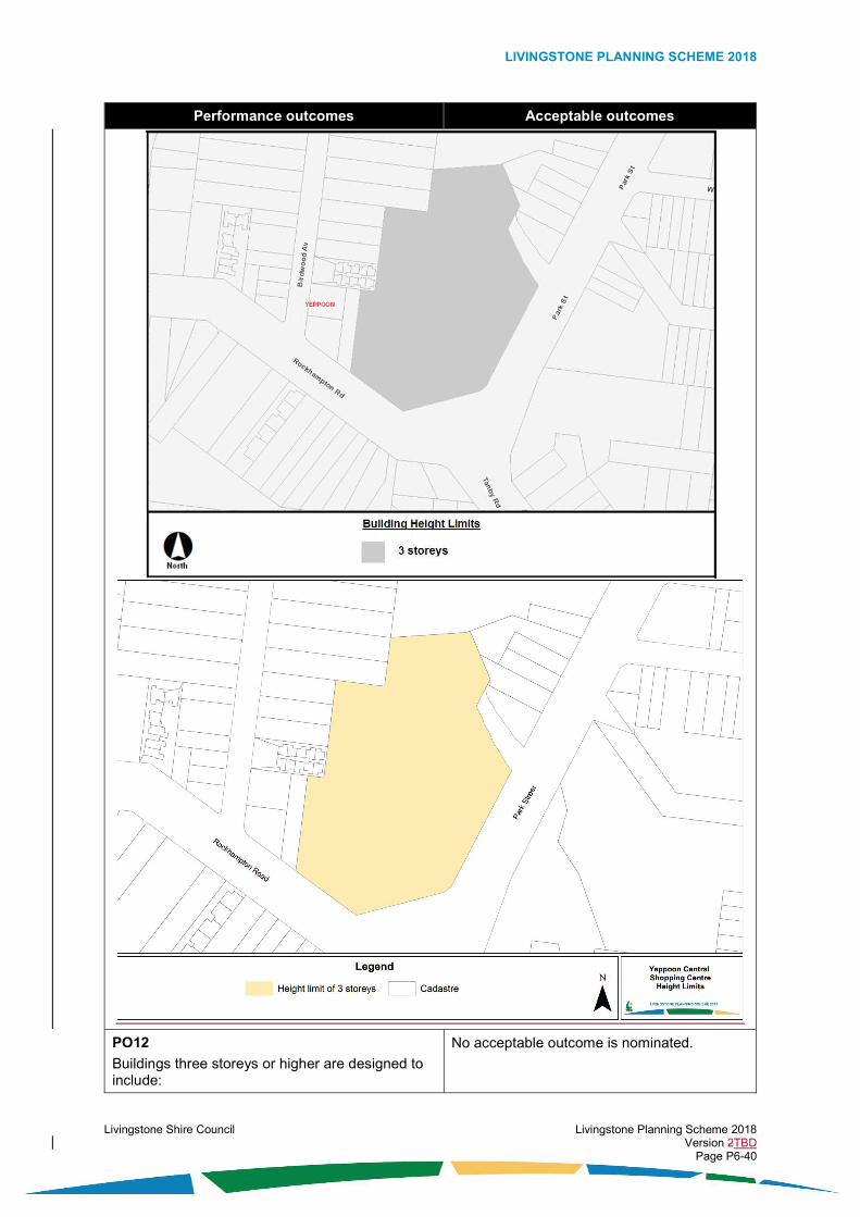
LIVINGSTONE PLANNING SCHEME 2018
Livingstone Shire Council Livingstone Planning Scheme 2018 Version 2TBD Page P6-40
Performance outcomes Acceptable outcomes
PO12
Buildings three storeys or higher are designed to include:
No acceptable outcome is nominated.
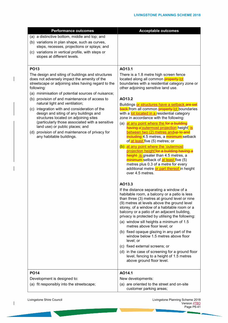
LIVINGSTONE PLANNING SCHEME 2018
Livingstone Shire Council Livingstone Planning Scheme 2018 Version 2TBD Page P6-41
Performance outcomes Acceptable outcomes
(a) a distinctive bottom, middle and top; and
(b) variations in plan shape, such as curves, steps, recesses, projections or splays; and
(c) variations in vertical profile, with steps or slopes at different levels.
PO13
The design and siting of buildings and structures does not adversely impact the amenity of the streetscape or adjoining sites having regard to the following:
(a) minimisation of potential sources of nuisance;
(b) provision of and maintenance of access to natural light and ventilation;
(c) integration with and consideration of the design and siting of any buildings and structures located on adjoining sites (particularly those associated with a sensitive land use) or public places; and
(d) provision of and maintenance of privacy for any habitable buildings.
AO13.1
There is a 1.8 metre high screen fence located along all common property lot boundaries with a residential category zone or other adjoining sensitive land use.
AO13.2
Buildings or structures have a setback are set back from all common property lot boundaries with a lot located in a residential category zone in accordance with the following:
(a) at any point where the for a building having a‘outermost projection height’ is between two (2) metres andup to and including 4.5 metres, a minimum setback of at least five (5) metres; or
(b) at any point where the ‘outermost projection height’for a building having a height is greater than 4.5 metres, a minimum setback of at least five (5) metres plus 0.3 of a metre for every additional metre or part thereof in height over 4.5 metres.
AO13.3
If the distance separating a window of a habitable room, a balcony or a patio is less than three (3) metres at ground level or nine (9) metres at levels above the ground level storey, of a window of a habitable room or a balcony or a patio of an adjacent building, privacy is protected by utilising the following:
(a) window sill heights a minimum of 1.5 metres above floor level; or
(b) fixed opaque glazing in any part of the window below 1.5 metres above floor level; or
(c) fixed external screens; or
(d) in the case of screening for a ground floor level, fencing to a height of 1.5 metres above ground floor level.
PO14
Development is designed to: (a) fit responsibly into the streetscape;
AO14.1
New developments: (a) are oriented to the street and on-site
customer parking areas;

LIVINGSTONE PLANNING SCHEME 2018
Livingstone Shire Council Livingstone Planning Scheme 2018 Version 2TBD Page P6-42
Performance outcomes Acceptable outcomes
(b) activate and engage with the street and important public spaces;
(c) create a pedestrian rather than car oriented street frontage;
(d) create a safe pedestrian environment at street level;
(e) create interesting street level façades which avoid expanses of blank walls oriented to the street; and
(f) provide an awning over pedestrian areas or shade trees where an awning would conflict with the streetscape (for example, heritage buildings).
(b) at ground level, include display windows for a minimum of eighty (80) per cent of the façade area; and
(c) result in ground floor tenancies which do not exceed ten (10) metres in width, or the ground floor tenancies are punctuated at least every fifteen (15) metres by a vertical design feature or shop window displays.
AO14.2
Buildings are built to the road frontage lot boundary at locations identified on Figure 6.2.4.4.1.3 – Yeppoon Business District Streetscape and an awning is provided over the footpath.
AO14.3
Where fronting a street or public space, any part of a building above ground floor level includes design features, windows or balconies to at least thirty (30) per cent of the façade area of each floor level.
AO14.4
Buildings have awnings over external pedestrian footpath areas and the awnings: (a) provide continuous weather protection; (b) are not higher than 7.5 metres from the
constructed pavement or footpath to the soffit of the awning; and
(c) extend from the building over the pedestrian footpath area the greater of the following: (i) three (3) metres; or (ii) a distance which finishes 0.5 of a
metre before any roadside kerb or vehicle parking area.
Note: The following figure illustrates the outcome sought.
PO15 AO15

LIVINGSTONE PLANNING SCHEME 2018
Livingstone Shire Council Livingstone Planning Scheme 2018 Version 2TBD Page P6-43
Performance outcomes Acceptable outcomes
All buildings provide opportunities for ground floor reuse and adaptation for alternative preferred uses.
Building ground floors have a floor to ceiling height of at least four (4) metres.
PO16
Where multi-storey buildings are developed, the design ensures that any accommodation activities have appropriate amenity and access to natural light and ventilation.
AO16
For a multi-storey building, Any part of a building over any storey located above the third storey three (3) storeys in heighthas a setback is set back in accordance with the following:
(a) a setback from road frontage lot boundaries minimum of at least six (6) metres from the front boundary but no more than ten (10) metres from the front boundary; and
(b) a setback from side boundary or rear lot boundaries of at least one-third of the ‘outermost projection height’ of the building.setbacks in accordance with the Queensland Development Code.
(c)
(d)(b)
PO17
The character of the major centre of Yeppoon
is reinforced by buildings that:
(a) reflect the area’s ‘main street’ character;
(b) are orientated towards streets and public spaces;
(c) strengthen the linkage between Anzac Parade and James Street.
AO17.1
Buildings have a setback from the primary road frontage lot boundary are set back a minimum of at least six (6) metres from the primary road frontage boundary to allow for landscape and forecourt areas at locations identified on Figure 6.2.4.4.1.3 – Yeppoon Business District Streetscape, to allow for landscape and forecourt areas.
AO17.2
Buildings are built to the road frontage lot boundary at locations identified on Figure 6.2.4.4.1.3 – Yeppoon Business District Streetscape, and an awning is provided over the footpath.
PO18
The design and siting of buildings contributes to the development of the major centre of Yeppoon as a place which has:
(a) a high level of pedestrian connectivity between destinations within the centre;
(b) a functional movement system;
(c) safe and highly accessible vehicle parking areas located at the rear of premises for customers; and
(d) safe and effective drop-off and collection areas at the rear of premises for service and delivery vehicles.
AO18.1
Development on land affected by a future vehicle or pedestrian connection or laneway identified on Figure 6.2.4.4.1.4 – Yeppoon Business District Laneways and Connections, provides the following:
(a) mid-block public access laneways that are dedicated as public roads and which provide two way traffic as follows:
(i) an eight (8) metres road reserve; and
(ii) a five (5) metre carriageway (parking on one side of road); and

LIVINGSTONE PLANNING SCHEME 2018
Livingstone Shire Council Livingstone Planning Scheme 2018 Version 2TBD Page P6-44
Performance outcomes Acceptable outcomes
(b) mid-block public access for pedestrians which:
(i) are a minimum of three (3) metres in width; and
(ii) consist of an open walkway, or an arcade through a building, or unrestricted public access through shops which extend from street to street; and
(c) in the event of the relocation of the Yeppoon Railway Station building, dedication as new road reserve the area of land indicated for a future road for the extension of Arthur Street between Normanby Street and James Street.
(d)
(e)(c)
PO19
Development extending from street to street provides inter-block connections, interaction between the internal uses and activity on the street.
AO19.1
Arcades are well lit, include active frontages for the full length of the facility, are able to be locked when not used and have an easily recognisable entry and exit.
AO19.2
Street to street connections provided by arcades or thoroughfares are provided when sites are redeveloped where indicated on Figure 6.2.4.4.1.4 – Yeppoon Business District Laneways and Connections.
PO20
The safety and effectiveness of vehicle laneways is not compromised by the introduction and proliferation of active uses along the laneway frontages.
AO20
Development fronting a vehicle laneway provides access only for loading, car parking, storage and rear access to buildings.
Figure 6.2.4.4.1.3 – Yeppoon Business District Streetscape

LIVINGSTONE PLANNING SCHEME 2018
Livingstone Shire Council Livingstone Planning Scheme 2018 Version 2TBD Page P6-45
Performance outcomes Acceptable outcomes
Figure 6.2.4.4.1.4 – Yeppoon Business District Laneways and Connections

LIVINGSTONE PLANNING SCHEME 2018
Livingstone Shire Council Livingstone Planning Scheme 2018 Version 2TBD Page P6-46
Performance outcomes Acceptable outcomes
PO21
Where located on a site fronting Anzac Parade, development enhances the amenity of public spaces and provides opportunities for public access to facilities in the private domain.
AO21.1
Where located on a site fronting Anzac Parade, development actively addresses footpaths with doorways and windows and provides opportunities for outdoor dining.
AO21.2
Where located on a site fronting Anzac Parade, building forecourt areas are provided and they include:
(a) planting features between the building and Anzac Parade;
(b) shade or weather protection structures are part of outdoor or semi-outdoor eating establishments along Anzac Parade; and
(c) front pedestrian entrances are located on and focused towards Anzac Parade.
Note: The following figure illustrates the outcome sought.

LIVINGSTONE PLANNING SCHEME 2018
Livingstone Shire Council Livingstone Planning Scheme 2018 Version 2TBD Page P6-47
Performance outcomes Acceptable outcomes
Appearance
PO22
The development is designed in a manner that contributes to a high level of visual amenity when viewed from the street, public places, and the surrounding area by incorporating elements including but not limited to the following:
(a) emphasis on entry points;
(b) orientation to the street and any public places;
(c) use of buildings, structures or vegetation to screen any waste storage areas and building plant from view of the street;
(d) inclusion of vegetation to screen any large unarticulated building walls;
(e) inclusion of vegetation at appropriate locations to enhance public streets and places and to provide shading for pedestrian comfort.
AO22.1
The development has a pedestrian entry point at or visible from the primary road frontage.
AO22.2
Any waste storage areas are screened from view of the street by one or more of the following:
(a) a solid screen fence; or
(b) a wall; or
(c) dense vegetation.
AO22.3
Any building plant:
(a) is screened from view of the street by one or more of the following:
(i) a solid screen fence, or
(ii) a roof design feature; or
(iii) a wall; or
(iv) dense vegetation; or
(b) is located within, underneath or central to the building so as to not be visible from the street.
AO22.4
There is a densely vegetated area having a depth of at least five (5) metres from the property lot boundary, located along all common property lot boundaries where adjoining any residential category zone.
AO22.5
The densely vegetated area specified in AO21AO22.4 complies with the following:
(a) there is a minimum of two (2) rounded canopy trees for every five (5) linear metres or part thereof of the length of the property lot boundary; and

LIVINGSTONE PLANNING SCHEME 2018
Livingstone Shire Council Livingstone Planning Scheme 2018 Version 2TBD Page P6-48
Performance outcomes Acceptable outcomes
(b) any established native tree species having a height exceeding two (2) metres, or a trunk diameter of thirty (30) centimetres are retained within vegetation area.
PO23
Buildings have an appearance which provides visual interest and contributes to a high level of visual amenity when viewed from the street, public places, and the surrounding area by use of the following: (a) vertical and horizontal articulation to create
shadow and break up the built form by use of fenestration, recesses, wall offsets, balconies, projections, splays or other building design features;
(b) external building walls having variations in textures, materials and colours; and
(c) external building materials which are unlikely to create a nuisance, discomfort or hazard due to solar reflection.
AO23.1
Buildings have a maximum unarticulated length of fifteen (15) metres to the street frontage.
AO23.2
External building walls have at least three (3) variations, with the variations consisting of one or more of the following:
(a) changes in surface textures; or
(b) changes in materials; or
(c) changes in colours.
AO23.3
The design of the building does not include glass or surfaces that are likely to: (a) reflect solar rays for prolonged periods due
to exterior finishes and design elements, or (b) create undue nuisance, discomfort or
hazards to any part of the surrounding locality.
PO24
Buildings are well designed and decorated to reflect the sub-tropical climate and coastal character of Yeppoon.
No acceptable outcome is nominated.
PO25
The roof of a building is designed in a manner that creates visual interest and can conceal any plant equipment.
No acceptable outcome is nominated.
PO26
The location of street trees, seating, shade structures, waste bins, drinking fountains, public transport stops and public art and the like are: (a) provided at a scale and location appropriate
to the design and layout of the centre;
(b) co-ordinated to create cohesive streetscapes and movement areas to soften the built form and provide increased user amenity; and
(c) located so as to retain at least a 1.5 metre wide clear pedestrian zone.
No acceptable outcome is nominated.
PO27
Development designed as stand-alone shopping centres does not occur unless they contribute to the amenity of the streetscape and maximise opportunities for outwardly-focused (or sleeved) active uses facing shopping
AO27
Where fronting active streets, large standalone shopping centres include: (a) shop display windows on street frontages
(excluding laneways) which are not opaque

LIVINGSTONE PLANNING SCHEME 2018
Livingstone Shire Council Livingstone Planning Scheme 2018 Version 2TBD Page P6-49
Performance outcomes Acceptable outcomes
streets, car parking areas, landscaped forecourts, and public spaces.
or covered with signage occupying more than fifty (50) per cent of window area; or
(b) ‘sleeving’ of smaller tenancies on large shopping centres.
PO28
Buildings which are located on corner sites or share boundaries to public spaces, including parks, are designed to express or emphasise the importance of their location through excellent architectural design.
AO28.1
Where a building is adjacent to a public place: (a) the building’s main entrance addresses the
public place; or
(b) the building’s design addresses the public place via openings, entrances or verandas; and
(c) that part of a building that shares a boundary with the open space zone is not fenced with the preferred approach to be the provision of landscaping or paving treatments to delineate the public space from private.
AO28.2
Buildings on corner sites provide active frontages to both street frontages and the main entrance addresses the principal street or the street corner.
PO29
Development retains horizontal vegetated breaks on hill slopes, in order to prevent the appearance of large, single, multi-storey buildings.
AO29
On sloping land: (a) buildings are stepped so that their maximum
height is contained within a line parallel with the ground;
(b) buildings on a slope greater than one (1) vertical in six (6) horizontal (16.6 per cent) are interrupted every twenty-five (25) metres (measured in the horizontal plane) by a six (6) metre wide break that includes deep planting of trees which will reach at least seven (7) metres at maturity; and
(c) buildings use different materials, colours or design elements to distinguish between different buildings separated on the slope.
Note: The following figure illustrates the outcome sought.
Vehicle parking areas and access
PO30 No acceptable outcome is nominated.

LIVINGSTONE PLANNING SCHEME 2018
Livingstone Shire Council Livingstone Planning Scheme 2018 Version 2TBD Page P6-50
Performance outcomes Acceptable outcomes
Parking areas are designed to minimise impacts on sensitive land use due to noise, car park lighting, vehicle lighting, and loss of privacy.
PO31
On-site vehicle parking areas do not compromise the walkability and active shop front focus of the streetscape and they are sited:
(a) to the side or the rear of buildings; or
(b) below ground level.
No acceptable outcome is nominated.
PO32
Access to sites is via existing crossovers and new crossovers do not interrupt key pedestrian areas unnecessarily.
No acceptable outcome is nominated.
PO33
When visible from the street, ancillary parking facilities and standalone parking stations are designed with external finishes and landscaping appropriate to the streetscape setting.
No acceptable outcome is nominated.
Infrastructure
PO34
Safe, accessible, robust and reliable infrastructure relating to access and parking, energy supply, roads, roof and allotment drainage, sewage and wastewater treatment and disposal, stormwater management, telecommunications, and water supply, is adequately provided for the development in accordance with best practice and endorsed standards for the location, and relative to the needs of the development.
AO34
The development complies with the requirements of the Development Works Code.

LIVINGSTONE PLANNING SCHEME 2018
Livingstone Shire Council Livingstone Planning Scheme 2018 Version 2TBD Page P6-51
6.3. Environmental category zone codes
6.3.1. Environmental management and conservation zone code
6.3.1.1. Application
This code applies to the assessment of development if it is identified as an applicable code for development, as specified in the assessment benchmarks column in the tables of assessment located in Part 5 of the planning scheme.
When using this code, reference should be made to section 5.3.2 and where applicable, section 5.3.3 located in Part 5.
All subject matter in this code is applicable to the development assessment, unless the following circumstance arises:
(1) The heading of a specific benchmarks for assessment table specifies otherwise; or
(2) A heading within a specific benchmarks for assessment table specifies that the outcomes apply to a specific type of development or to development at a specific location; or
(3) A performance outcome or acceptable outcome specifies that the outcomes apply to a specific type of development or to development at a specific location.
In the circumstance where point (2) or point (3) above arises the following applies:
(1) the development assessment outcomes apply only to the type of development specified or only to development at the location specified; and
(2) the development must still be assessed against all other general subject matter of the code (for example, assessment benchmarks including but not limited to those relating to built form, appearance, or general land use).
6.3.1.2. Purpose
The purpose of the environmental management and conservation zone code is:
(1) to protect land identified as supporting significant biological diversity and ecological integrity;
(2) to protect the desired character, amenity and form for the environmental management and conservation zone;
(3) to provide for low-impact development opportunities; and
(4) to facilitate the achievement of the overall outcomes sought for zone.
6.3.1.3. Overall outcomes
The purpose of the code will be achieved through the following overall outcomes:
(1) the environmental management and conservation zone is characterised by the predominance of environment and landscape features conserved in its natural state;
(2) development occurs only in the following circumstances:
(a) significant adverse impacts on biological diversity and ecological integrity are avoided; and
(b) there is a community benefit; and
(c) the development is predominantly nature based, it has low-impacts, and it is for, ancillary to, or associated with one or more of the following:
(i) recreation activities for the enjoyment and appreciation of the natural environment; or
(ii) ecotourism; or
(iii) education about biological diversity, ecological integrity or cultural features of a site; or

LIVINGSTONE PLANNING SCHEME 2018
Livingstone Shire Council Livingstone Planning Scheme 2018 Version 2TBD Page P6-52
(iv) cultural practices; or
(v) scientific practices; or
(vi) biodiscovery; or
(vii) necessary infrastructure; or
(viii) the conservation, protection or management of biological diversity and ecological integrity; and
(3) the development is compatible with a form that is characterised by:
(a) retention of the natural environment in its natural state as far as practicable;
(b) development being designed and sited to appropriately integrate with natural environment and landscape features of the site;
(c) low site coverage of any buildings and structures;
(d) low heights for any buildings and structures;
(4) the development does not adversely affect on-site or off-site scenic amenity.
6.3.1.4. Specific benchmarks for assessment
Table 6.3.1.4.1 – Outcomes for development that is accepted subject to requirements and assessable development
Performance outcomes Acceptable outcomes
Land use
PO1
The use has a direct focus on the natural environment and it is associated with one or more of the following:
(a) biodiscovery activities; or
(b) caretaking; or
(c) conservation, protection or management of biological diversity and ecological integrity; or
(d) cultural practices; or
(e) ecotourism; or
(f) education about biological diversity, ecological integrity or cultural features of a site; or
(g) recreation activities for the enjoyment and appreciation of the natural environment; or
(h) scientific practices; or
(i) necessary infrastructure; or
(j) the conservation, protection or management of biological diversity and ecological integrity.
No acceptable outcome is nominated.
PO2
The use has low-impacts and does not result in significant adverse impacts on the values of the site and surrounds, including but not limited to the following:
(a) large tracts and corridors of established remnant vegetation and habitat; or
No acceptable outcome is nominated.

LIVINGSTONE PLANNING SCHEME 2018
Livingstone Shire Council Livingstone Planning Scheme 2018 Version 2TBD Page P6-53
Performance outcomes Acceptable outcomes
(b) inland and coastal waterways and wetlands; or
(c) riparian vegetation; or
(d) visually prominent mainland and island mountains, hills, ridges, headlands, dunes, beaches; or
(e) important urban green break areas; or
(f) cultural heritage features.
Built form
PO3
The scale of the development is small and is subservient to the surrounding natural environment and landscape features of the site and surrounding area.
No acceptable outcome is nominated.
PO4
The height and bulk of buildings and structures are visually unobtrusive when viewed from public places, adjoining sites or the surrounding area.
AO4.1
The height of buildingsBuilding height and the height of structures does not exceed the following:
(a) two (2) storeys and 8.5 metres above ground level where the ground has a slope less than fifteen (15) per cent; or
(b) two (2) storeys and ten (10) metres above ground level where the ground has a slope equal to or greater than fifteen (15) per cent.
AO4.2
Buildings or structures having an ‘outermost projection height’ exceeding two (2) metres, have a are setback from all lot boundaries of at least a minimum of fifteen (15) metres from all property boundaries.
PO5
The development has very low site coverage.
No acceptable outcome is nominated.
Appearance
PO6
The development results in a high level of on-site and off-site scenic amenity having regard to the following:
(a) appropriate integration with environmentally significant vegetation and habitat;
(b) appropriate integration with wetlands and waterways;
(c) siting buildings and structures so that there is minimal disruption to the skyline, vegetation on ridgelines and prominent slopes, or riparian vegetation;
(d) use of building materials and colours that are drawn from or complement the natural landscape of the setting;
No acceptable outcome is nominated.

LIVINGSTONE PLANNING SCHEME 2018
Livingstone Shire Council Livingstone Planning Scheme 2018 Version 2TBD Page P6-54
Performance outcomes Acceptable outcomes
(e) avoidance of the creation of extended straight lengths of new road or internal access roads that are able to be seen from public places;
(f) avoidance of fencing, landscaping and lighting treatments that are urban in scale and appearance if the site is in a non-urban setting;
(g) retention of mature vegetation or planting of new vegetation in building setback areas, particularly the setback areas located within the sight of major public roads and public viewer places;
(h) location of buildings and other structures so as not to obscure or interrupt any significant views from a public viewer place to an identified significant scenic landscape feature; and
(i) minimising the scarring of the land due to earthworks and the use of large retaining walls at highly visible locations.

LIVINGSTONE PLANNING SCHEME 2018
Livingstone Shire Council Livingstone Planning Scheme 2018 Version 2TBD Page P6-55
6.4. Industry category zone codes
6.4.1. Low impact industry zone code
6.4.1.1. Application
This code applies to the assessment of development if it is identified as an applicable code for development, as specified in the assessment benchmarks column in the tables of assessment located in Part 5 of the planning scheme.
When using this code, reference should be made to section 5.3.2 and where applicable, section 5.3.3 located in Part 5 of the planning scheme.
All subject matter in this code is applicable to the development assessment, unless the following circumstance arises:
(1) The heading of a specific benchmarks for assessment table specifies otherwise; or
(2) A heading within a specific benchmarks for assessment table specifies that the outcomes apply to a specific type of development or to development at a specific location; or
(3) A performance outcome or acceptable outcome specifies that the outcomes apply to a specific type of development or to development at a specific location.
In the circumstance where point (2) or point (3) above arises the following applies:
(1) the development assessment outcomes apply only to the type of development specified or only to development at the location specified; and
(2) the development must still be assessed against all other general subject matter of the code (for example, assessment benchmarks including but not limited to those relating to built form, appearance, or general land use).
6.4.1.2. Purpose
The purpose of the low impact industry zone code is:
(1) to identify the desired character and amenity for the zone and to protect it from incompatible development;
(2) to provide for the development of low impact industry zones as places comprising a range and mixture of low impact uses from within the industrial activities group, business activities group, and special activities group;
(3) to provide for the development of a limited range and mixture of low impact uses from within other activity groups only if they are compatible with and do not limit or compromise the development of preferred land uses;
(4) to enable low impact industry zones to strengthen and maintain their role and function in the planning scheme area;
(5) to establish one (1) precinct within the zone where particular development outcomes are specified, and the precincts is identified as follows:
(a) the Tanby Road Local Business Precinct; and
(6) to facilitate the achievement of the overall outcomes sought for the zone.
6.4.1.3. Overall outcomes
The purpose of the code will be achieved through the following overall outcomes:
(1) the development is:
(a) a use from within the industrial activities group which has low impacts; or
(b) a use from within the business activities group which has low impacts; or
(c) a use from within the special activities group which has low impacts; or
(d) a use which:

LIVINGSTONE PLANNING SCHEME 2018
Livingstone Shire Council Livingstone Planning Scheme 2018 Version 2TBD Page P6-56
(i) is compatible with and supports a preferred use from within the industrial activities group, business activities group, and special activities group; and
(ii) does not limit or compromise the development of a preferred use from within the industrial activities group, business activities group, and special activities group; and
(iii) has relatively low impacts;
(2) the development of a use from within the industrial activities group is a preferred use within the zone in the following circumstances:
(a) it is a low impact industry; or
(b) it is a research and technology industry (being only a computer server facility); or
(c) it is a service industry; or
(d) it is a warehouse;
(3) the development of a use from within the business activities group is a preferred use within the zone in the following circumstances:
(a) it is an agricultural supplies store; or
(b) it is a garden centre; or
(c) it is hardware and trade supplies; or
(d) it is a sales office;
(4) the development of a use from within the special activities group is a preferred use within the zone in the following circumstances:
(a) it is emergency services; or
(b) it is a parking station; or
(c) it is a transport depot; or
(d) it is a landing; or
(e) it is a utility installation having low impacts, and it is an essential component of infrastructure servicing the community (for example, water supply pump station, sewerage pump station);
(5) if the development is a use from within the industrial activities group, business activities group or the special activities group and it is not identified as a preferred use, it occurs within the zone only in the following circumstances:
(a) it is compatible with and does not limit or compromise the development of the preferred uses identified in Overall Outcome (2), Overall Outcome (3) or Overall Outcome (4);
(b) it has low impacts;
(c) it is designed to appropriately integrate with development in the immediate area;
(d) there is appropriate design and siting to ensure that there are no adverse impacts on any sensitive land use;
(e) it is consistent with the built form and appearance of development in the immediate area;
(f) the use:
(i) is bulk landscape supplies; or
(ii) is a car wash; or
(iii) is a crematorium; or
(iv) is a funeral parlour; or
(v) is a market; or
(vi) is outdoor sales; or

LIVINGSTONE PLANNING SCHEME 2018
Livingstone Shire Council Livingstone Planning Scheme 2018 Version 2TBD Page P6-57
(vii) it is a service station; or
(viii) is a showroom; or
(ix) is a substation; or
(x) is veterinary services;
(6) if the development is for a use that is not within the industrial activities group, business activities group or special activities group, it occurs within the zone only in the following circumstances:
(a) it is compatible with and does not limit or compromise the development of the preferred uses identified in Overall Outcome (2), Overall Outcome (3) or Overall Outcome (4);
(b) it has low impacts;
(c) it is designed to integrate with development in the immediate area;
(d) there is appropriate design and siting to ensure that there are no adverse impacts on any sensitive land use;
(e) it is consistent with the built form and appearance of development in the immediate area;
(f) the use:
(i) is a caretaker’s accommodation; or
(ii) is an environment facility; or
(iii) is a food and drink outlet which is small in scale and primarily services the following:
(A) workers or customers of other development in the zone; or
(B) the convenience needs of travellers along major transport routes; or
(iv) is indoor sport and recreation; or
(v) is a park; or
(vi) is a rural industry; or
(vii) is a wholesale nursery;
(7) the development of any use which results in medium impacts, high impacts, or extreme impacts and risks due to emissions, or dangerous or hazardous goods and activities, does not occur within the zone;
(8) the development is compatible with an urban form that is characterised by:
(a) low to moderate building heights;
(b) moderate to high site cover;
(c) use of vegetation screening and buffering between development and any adjoining sensitive land use; and
(9) the appearance of development results in a high level of visual amenity when viewed from any major transport routes or scenic transport routes;
(10) the development is provided with adequate infrastructure and essential services; and
Where located in the Tanby Road Local Business Precinct
Note: The overall outcomes of the Tanby Road Local Business Precinct are additional to those of the zone and take precedence in the event of a conflict.
(11) the development:
(a) is a use which:
(i) is a child care centre; or
(ii) is an office (if small in scale); or

LIVINGSTONE PLANNING SCHEME 2018
Livingstone Shire Council Livingstone Planning Scheme 2018 Version 2TBD Page P6-58
(iii) is a medical centre; or
(iv) is a continuation of an existing use; and
(b) the use:
(i) is oriented towards supporting the tourism and recreation development potential of the immediate area;
(ii) does not involve a drive-through facility;
(iii) is designed to integrate with development in the immediate area;
(iv) does not undermine the viability, role or function of established neighbourhood centres, local centres, district centres, or major centres; and
(v) provides visual interest and contributes to a high level of visual amenity when viewed from the street,public places, and the surrounding area; and
(12) the development does not result in the provision of additional access points fronting Tanby Road or Rawlings Street; and
(13) in the event of the amalgamation of lots in this precinct or any integrated development over multiple lots, the on-site parking and movement system is safe, is appropriately integrated with the site layout, and it does not adversely impact the safety of Tanby Road.
Editor’s note: In consideration of the current ownership within the Tanby Road local business precinct , existing access driveways off Tanby Road, Rawlings Street and Melbourne Street, and the introduction of a signalised intersection at this location, it is expected that these sites will be considered as one for any new development proposals regarding formalising access (whether this is by amalgamation of lots or not). This will enhance the potential to develop the land in an efficient and coordinated manner.
6.4.1.4. Specific benchmarks for assessment
Table 6.4.1.4.1 – Outcomes for development that is accepted subject to requirements and assessable development
Performance outcomes Acceptable outcomes
Land use
PO1
If the use includes office space, the office space is a scale that is ancillary to and has a direct nexus with the use conducted on the site.
AO1.1
If the use includes office space, the office area does not exceed twenty (20) per cent of the total gross floor area of the use.
PO2
If the use is a use from within the industrial activities group and the development involves direct sales to the public, the direct sales to the public only occur at a scale that is ancillary to the primary activities of the use and the items for sale have a direct nexus with the use conducted on the site.
AO2.1
If the development is a use from within the industrial activities group, direct sales to the public are restricted to the sale of items produced on site.
AO2.2
If the development is a use from within the industrial activities group, the sales area does not exceed ten (10) per cent of the total gross floor area of the use.
Built Form
PO3
The height and bulk of buildings and structures are consistent with the intended character of the zone and do not adversely impact the
AO3.1
The height of buildingsBuilding height does not exceed twelve (12) metres.

LIVINGSTONE PLANNING SCHEME 2018
Livingstone Shire Council Livingstone Planning Scheme 2018 Version 2TBD Page P6-59
Performance outcomes Acceptable outcomes
character or amenity of the streetscape, adjoining sites and surrounding area.
AO3.2
Site cover does not exceed seventy-five (75) per cent.
PO4
The design and siting of buildings and structures does not adversely impact the amenity of the streetscape or adjoining sites having regard to the following:
(a) minimisation of potential sources of nuisance;
(b) enhancing the ability to soften the visual impact of large expanses of building walls by the provision of areas for the planting of dense screening vegetation;
(c) provision of and maintenance of access to natural light and ventilation; and
(d) provision of and maintenance of privacy for any habitable buildings.
AO4.1
There is a 1.8 metre high screen fence located along all common property lot boundaries where adjoining a residential category zone or a township zone.
AO4.2
Buildings have a setback are set back from road frontage lot boundaries in accordance with the following:
(a) a setback from the primary road frontage lot boundary a minimum of at least six (6) metres; and
(a)(b) a setback from a secondary road frontage lot boundary of at least three (3) metres; and
(b)(c) if located at a site adjoining an identified scenic transport route on an overlay map, a setback a minimum from the scenic transport route lot boundary of at least ten (10) metres.
AO4.3
If adjoining a residential category zone or a township zone, bBuildings and or structures have a setback are set back from all common side and rear property lot boundaries with a lot located in a residential category zone in accordance with the following:
(a) at any point where the for a building or structure having a‘outermost projection height’ is between two (2) metres up to and including 4.5 metres, a minimum setback of at least five (5) metres; or
(b) at any point where the ‘outermost projection height’ is for a building or structure having a height greater than 4.5 metres, a minimum setback of at least five (5) metres plus 0.3 of a metre for every additional metre or part thereof in height over 4.5 metres.
AO4.4
If adjoining a residential category zone or a township zone, any windows that have direct views into adjoining residential buildings are provided with fixed screening that is a maximum of seventy-five (75) per cent transparent to obscure views into the adjoining residential

LIVINGSTONE PLANNING SCHEME 2018
Livingstone Shire Council Livingstone Planning Scheme 2018 Version 2TBD Page P6-60
Performance outcomes Acceptable outcomes
building and to maintain privacy for those residents.
Appearance
PO5
The development is designed in a manner that contributes to a high level of visual amenity when viewed from the street, public places, and the surrounding area by incorporating elements including but not limited to the following:
(a) emphasis on entry points;
(b) orientation to the street and any public places;
(c) inclusion of walls, structures or vegetation to screen any material stockpiles, waste storage areas, and building plant from view of the street or other public places;
(d) inclusion of vegetation to soften the impact of any large unarticulated building walls when viewed from residential category zones and scenic transport routes; and
(e) inclusion of vegetation between buildings and property lot boundaries that adjoin major transport routes.
AO5.1
The development has a pedestrian entry point at or visible from the primary road frontage.
AO5.2
Any ancillary office space or sales areas of each building are sited and oriented towards the primary road frontage.
AO5.3
Any material stockpiles and waste storage areas are screened from view of the street and adjoining public places by one or more of the following:
(a) a solid screen fence; or
(b) a wall; or
(c) dense vegetation.
AO5.4
Any building plant:
(a) is screened from view of the street by one or more of the following:
(i) a solid screen fence, or
(ii) a roof design feature; or
(iii) a wall; or
(iv) dense vegetation; or
(b) is located within, underneath or central to the building so as to not be visible from the street.
AO5.5
There is a densely vegetated buffer area having a depth of at least five (5) metres from the property lot boundary, located along all common property lot boundaries where adjoining any residential category zone or a township zone.
AO5.6
There is a densely vegetated area having a depth of at least ten (10) metres from the property lot boundary, located along all property lot boundaries which adjoin an identified scenic transport route on an overlay map.
AO5.7

LIVINGSTONE PLANNING SCHEME 2018
Livingstone Shire Council Livingstone Planning Scheme 2018 Version 2TBD Page P6-61
Performance outcomes Acceptable outcomes
The densely vegetated areas specified in AO5.5 and AO5.6 comply with the following:
(a) there is a minimum of two (2) rounded canopy trees for every five (5) linear metres or part thereof of the length of the road frontage property lot boundary; and
(b) there is a minimum of two (2) shrubs for every three (3) linear metres or part thereof of the length of the road frontage property lot boundary; and
(c) any established native tree species having a height exceeding two (2) metres, or a trunk diameter of thirty (30) centimetres are retained within vegetation area.
AO5.8
There is a vegetated area having a depth of at least two (2) metres from the property lot boundary, located along all road frontage boundaries of any roads classified as a collector road, arterial road, or main road (other than a boundary adjoining an identified scenic transport route on an overlay map), excluding the access driveway.
Table 6.4.1.4.2 - Additional outcomes for assessable development
Performance outcomes Acceptable outcomes
Land use
PO6
The use is:
(a) a preferred use for the zone (as identified in the overall outcomes for the zone); or
(b) another use identified in the overall outcomes for the zone that:
(i) is compatible with and supports a preferred use for the zone or
(ii) will not limit or compromise the development of a preferred use for the zone.
No acceptable outcome is nominated.
PO7
If the use is not a preferred use for the zone (as identified in the overall outcomes for the zone), the use does not undermine the viability, role or function of centres in the planning scheme centres hierarchy.
No acceptable outcome is nominated.
PO8
The use appropriately integrates with any established uses in the immediate area.
No acceptable outcome is nominated.
PO9
The use is located, designed and operated in a manner that maintains public health and safety.
No acceptable outcome is nominated.

LIVINGSTONE PLANNING SCHEME 2018
Livingstone Shire Council Livingstone Planning Scheme 2018 Version 2TBD Page P6-62
Performance outcomes Acceptable outcomes
PO10
The use does not result in medium impacts, high impacts, or extreme impacts and risks due to emissions, or dangerous or hazardous goods and activities.
AO10.1
The use is not any of the following uses from the industrial activities group:
(a) High impact industry; or
(b) Marine industry; or
(c) Medium impact industry; or
(d) Research and technology industry (other than a computer server facility); or
(e) Special industry.
AO10.2
The use is not any of the following uses from the special activities group:
(a) Major electricity infrastructure; or
(b) Utility installation being one of the following:
(i) a water supply treatment plant; or
(ii) a sewage treatment plant; or
(iii) a waste transfer station (for all refuse other than a recycling community drop-off facility); or
(iv) a waste landfill.
Infrastructure
PO11
Safe, accessible, robust and reliable infrastructure relating to access and parking, energy supply, roads, roof and allotment drainage, sewage and wastewater treatment and disposal, stormwater management, telecommunications, and water supply, is adequately provided for the development in accordance with best practice and endorsed standards for the location, and relative to the needs of the development.
AO11.1
The development complies with the requirements of the Development Works Code.

LIVINGSTONE PLANNING SCHEME 2018
Livingstone Shire Council Livingstone Planning Scheme 2018 Version 2TBD Page P6-63
6.4.2. Medium impact industry zone code
6.4.2.1. Application
This code applies to the assessment of development if it is identified as an applicable code for development, as specified in the assessment benchmarks column in the tables of assessment located in Part 5 of the planning scheme.
When using this code, reference should be made to section 5.3.2 and where applicable, section 5.3.3 located in Part 5 of the planning scheme.
All subject matter in this code is applicable to the development assessment, unless the following circumstance arises:
(1) The heading of a specific benchmarks for assessment table specifies otherwise; or
(2) A heading within a specific benchmarks for assessment table specifies that the outcomes apply to a specific type of development or to development at a specific location; or
(3) A performance outcome or acceptable outcome specifies that the outcomes apply to a specific type of development or to development at a specific location.
In the circumstance where point (2) or point (3) above arises the following applies:
(1) the development assessment outcomes apply only to the type of development specified or only to development at the location specified; and
(2) the development must still be assessed against all other general subject matter of the code (for example, assessment benchmarks including but not limited to those relating to built form, appearance, or general land use).
6.4.2.2. Purpose
The purpose of the medium impact industry zone code is:
(1) to identify the desired character and amenity for the zone and to protect it from incompatible development;
(2) to provide for the development of medium impact industry zones as places comprising a range and mixture of different uses from within the industrial activities group, business activities group and special activities group (where they have medium impacts or are likely to have medium impacts);
(3) to provide for the development of a limited range and mixture of uses from within other activities groups only if they are compatible with and do not limit or compromise the development of preferred land uses;
(4) to enable medium impact industry zones to strengthen and maintain their role and function in the planning scheme area; and
(5) to facilitate the achievement of the overall outcomes sought for the zone.
6.4.2.3. Overall outcomes
The purpose of the code will be achieved through the following overall outcomes:
(1) the development is:
(a) a use from within the industrial activities group which has impacts that are considered to be medium to low; or
(b) a use from within the business activities group which has impacts that are considered to be medium to low; or
(c) a use from within the special activities group which has impacts that are considered to be medium to low; or
(d) a use which:
(i) is compatible with and supports a preferred use within the industrial activities group, business activities group, and special activities group;

LIVINGSTONE PLANNING SCHEME 2018
Livingstone Shire Council Livingstone Planning Scheme 2018 Version 2TBD Page P6-64
(ii) does not limit or compromise the development of a preferred use within the industrial activities group, business activities group, and special activities group; and
(iii) has medium to low impacts;
(2) the development of a use within the industrial activities group is a preferred use within the zone in the following circumstances:
(a) it is a low impact industry; or
(b) it is a marine industry; or
(c) it is a medium impact industry; or
(d) it is a research and technology industry; or
(e) it is a service industry; or
(f) it is a warehouse;
(3) the development of a use within the business activities group is a preferred use within the zone in the following circumstances:
(a) it is an agricultural supplies store; or
(b) it is bulk landscape supplies; or
(c) it is a car wash; or
(d) it is hardware and trade supplies; or
(e) it is outdoor sales; or
(f) it is a sales office;
(4) the development of a use within the special activities group is a preferred use within the zone in the following circumstances:
(a) it is a crematorium; or
(b) it is emergency services; or
(c) it is a landing; or
(d) it is a parking station; or
(e) it is a telecommunications facility; or
(f) it is a transport depot; or
(g) it is a substation; or
(h) it is a utility installation that has low impacts and which is an essential component of infrastructure servicing the community (for example, water supply pump station, sewerage pump station);
(5) if the development is a use from within the business activities group or special activities group and it is not identified as a preferred use, it occurs within the zone only in the following circumstances:
(a) it is compatible with and does not limit or compromise the development of the preferred uses identified in Overall Outcome (2) or Overall Outcome (3) or Overall Outcome (4);
(b) it has medium to low impacts;
(c) it is designed to integrate with development in the immediate area;
(d) it is consistent with the built form and appearance of development in the immediate area;
(e) the use:
(i) is air services (being for an emergency helipad); or
(ii) a garden centre; or

LIVINGSTONE PLANNING SCHEME 2018
Livingstone Shire Council Livingstone Planning Scheme 2018 Version 2TBD Page P6-65
(iii) is a market; or
(iv) major electricity infrastructure; or
(v) it is a service station; or
(vi) is a veterinary services;
(6) the development of a use that is not within the industrial activities group, business activities group, or special activities group occurs within the zone only in the following circumstances:
(a) it is compatible with and does not limit or compromise the development of the preferred uses identified in Overall Outcome (2) or Overall Outcome (3) or Overall Outcome (4);
(b) it has relatively medium to low impacts;
(c) it is designed to integrate with development in the immediate area;
(d) it is consistent with the built form and appearance of development in the immediate area;
(e) the use:
(i) is animal keeping; or
(ii) is aquaculture (for example, where involving tanks enclosed within a building); or
(iii) is a caretaker’s accommodation; or
(iv) is an environment facility; or
(v) is a food and drink outlet which is small in scale and primarily services the workers or customers of other development in the zone; or
(vi) is intensive horticulture; or
(vii) is a park; or
(viii) is rural industry; or
(ix) is a wholesale nursery; or
(x) is a winery;
(7) the development of any use which results in high impacts, or extreme impacts and risks due to emissions, dangerous or hazardous goods and activities does not occur within the zone;
(8) the development is compatible with an urban form that is characterised by:
(a) low to moderate building heights;
(b) moderate to high site cover; and
(c) use of vegetation screening and buffering between development and any adjoining sensitive land use;
(9) the appearance of development results in a high level of visual amenity when viewed from any major transport routes or scenic transport routes; and
(10) the development is provided with adequate infrastructure and essential services.
6.4.2.4. Specific benchmarks for assessment
Table 6.4.2.4.1 – Outcomes for development that is accepted subject to requirements and assessable development
Performance outcomes Acceptable outcomes
Land use
PO1
If the use includes office space, the office space is a scale that is ancillary to and has a direct nexus with the use conducted on the site.
AO1.1
If the use includes office space, the office area does not exceed twenty (20) per cent of the total gross floor area of the use.

LIVINGSTONE PLANNING SCHEME 2018
Livingstone Shire Council Livingstone Planning Scheme 2018 Version 2TBD Page P6-66
Performance outcomes Acceptable outcomes
PO2
If the use is a use from within the industrial activities group and the development involves direct sales to the public, the direct sales to the public only occur at a scale that is ancillary to the primary activities of the use and the items for sale have a direct nexus with the use conducted on the site.
AO2.1
If the development is a use from within the industrial activities group, direct sales to the public are restricted to the sale of items produced on site.
AO2.2
If the development is a use from within the industrial activities group, the sales area does not exceed ten (10) per cent of the total gross floor area of the use.
Built Form
PO3
The height and bulk of buildings and structures are consistent with the intended character of the zone and do not adversely impact the character or amenity of the streetscape, adjoining sites and surrounding area.
AO3.1
The height of buildingsBuilding height does not exceed fifteen (15) metres above ground level.
AO3.2
Site cover does not exceed seventy-five (75) per cent.
PO4
The design and siting of buildings and structures does not adversely impact the amenity of the streetscape or adjoining sites having regard to the following:
(a) minimisation of potential sources of nuisance;
(b) enhancing the ability to soften the visual impact of large expanses of building walls by the provision of areas for the planting of dense screening vegetation;
(c) provision of and maintenance of access to natural light and ventilation; and
(d) provision of and maintenance of privacy for any habitable buildings.
AO4.1
There is a 1.8 metre high screen fence located along all common property lot boundaries where adjoining a residential category zone or a township zone.
AO4.2
Buildings have a setback are set back from road frontage lot boundaries in accordance with the following:
(a) a setback from the primary road frontage lot boundary a minimum of at least six (6) metres; and
(a)(b) a setback from a secondary road frontage lot boundary of at least three (3) metres; and
(b)(c) if located at a site adjoining an identified scenic transport route on an overlay map, a setback from the scenic transport route lot boundary minimum of at least ten (10) metres.
AO4.3
If adjoining a residential category zone or a township zone, bBuildings and or structures having an ‘outermost projection height’ exceeding two (2) metres have a setbackare set back from all common side and rear property lot boundaries with a lot located in a residential category zone or a township zone in accordance with the following:
(a) at any point where the for a building or structure having a‘outermost projection
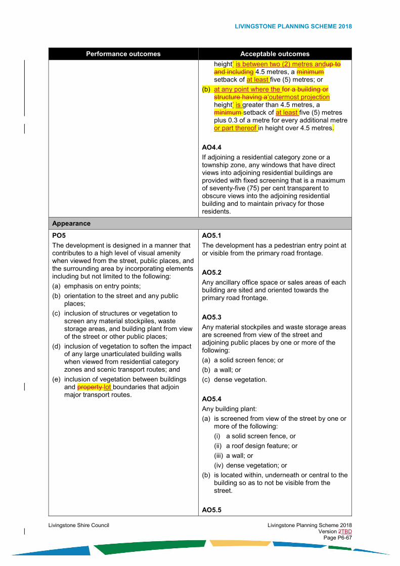
LIVINGSTONE PLANNING SCHEME 2018
Livingstone Shire Council Livingstone Planning Scheme 2018 Version 2TBD Page P6-67
Performance outcomes Acceptable outcomes
height’ is between two (2) metres andup to and including 4.5 metres, a minimum setback of at least five (5) metres; or
(b) at any point where the for a building or structure having a‘outermost projection height’ is greater than 4.5 metres, a minimum setback of at least five (5) metres plus 0.3 of a metre for every additional metre or part thereof in height over 4.5 metres.
AO4.4
If adjoining a residential category zone or a township zone, any windows that have direct views into adjoining residential buildings are provided with fixed screening that is a maximum of seventy-five (75) per cent transparent to obscure views into the adjoining residential building and to maintain privacy for those residents.
Appearance
PO5
The development is designed in a manner that contributes to a high level of visual amenity when viewed from the street, public places, and the surrounding area by incorporating elements including but not limited to the following:
(a) emphasis on entry points;
(b) orientation to the street and any public places;
(c) inclusion of structures or vegetation to screen any material stockpiles, waste storage areas, and building plant from view of the street or other public places;
(d) inclusion of vegetation to soften the impact of any large unarticulated building walls when viewed from residential category zones and scenic transport routes; and
(e) inclusion of vegetation between buildings and property lot boundaries that adjoin major transport routes.
AO5.1
The development has a pedestrian entry point at or visible from the primary road frontage.
AO5.2
Any ancillary office space or sales areas of each building are sited and oriented towards the primary road frontage.
AO5.3
Any material stockpiles and waste storage areas are screened from view of the street and adjoining public places by one or more of the following:
(a) a solid screen fence; or
(b) a wall; or
(c) dense vegetation.
AO5.4
Any building plant:
(a) is screened from view of the street by one or more of the following:
(i) a solid screen fence, or
(ii) a roof design feature; or
(iii) a wall; or
(iv) dense vegetation; or
(b) is located within, underneath or central to the building so as to not be visible from the street.
AO5.5

LIVINGSTONE PLANNING SCHEME 2018
Livingstone Shire Council Livingstone Planning Scheme 2018 Version 2TBD Page P6-68
Performance outcomes Acceptable outcomes
There is a densely vegetated area having a depth of at least five (5) metres from the property lot boundary, located along all common property lot boundaries where adjoining any residential category zone or a township zone.
AO5.6
There is a densely vegetated area having a depth of at least ten (10) metres from the property lot boundary, located along all property lot boundaries which adjoin an identified scenic transport route on an overlay map.
AO5.7
The densely vegetated areas specified in AO5.5 and AO5.6 comply with the following:
(a) there is a minimum of two (2) rounded canopy trees for every five (5) linear metres or part thereof of the length of the road frontage property lot boundary; and
(b) there is a minimum of two (2) shrubs for every three (3) linear metres or part thereof of the length of the road frontage property lot boundary; and
(c) any established native tree species having a height exceeding two (2) metres, or a trunk diameter of thirty (30) centimetres are retained within vegetation area.
AO5.8
There is a vegetated area having a depth of at least two (2) metres from the property lot boundary, located along all road frontage boundaries of any roads classified as a collector road, arterial road, or main road (other than a boundary adjoining an identified scenic transport route on an overlay map), excluding the access driveway.
Table 6.4.2.4.2 - Additional outcomes for assessable development
Performance outcomes Acceptable outcomes
Land use
PO6 The use is: (a) a preferred use for the zone (as identified in
the overall outcomes for the zone); or
(b) another use identified in the overall outcomes that:
(i) is compatible with and supports a preferred use for the zone; or
No acceptable outcome is nominated.

LIVINGSTONE PLANNING SCHEME 2018
Livingstone Shire Council Livingstone Planning Scheme 2018 Version 2TBD Page P6-69
Performance outcomes Acceptable outcomes
(ii) does not limit or compromise the development of a preferred use for the zone.
PO7
If the use is not a preferred use for the zone (as identified in the overall outcomes for the zone), the use does not undermine the viability, role or function of centres in the planning scheme centres hierarchy.
No acceptable outcome is nominated.
PO8
The use appropriately integrates with any established uses in the immediate area.
No acceptable outcome is nominated.
PO9
The use is located, designed and operated in a manner that maintains public health and safety.
No acceptable outcome is nominated.
PO10
The use does not result in high impacts, or extreme impacts and risks due to emissions, or dangerous or hazardous goods and activities.
No acceptable outcome is nominated.
Infrastructure
PO11 Safe, accessible, robust and reliable infrastructure relating to access and parking, energy supply, roads, roof and allotment drainage, sewage and wastewater treatment and disposal, stormwater management, telecommunications, and water supply, is adequately provided for the development in accordance with best practice and endorsed standards for the location, and relative to the needs of the development.
AO11.1 The development complies with the requirements of the Development Works Code.

LIVINGSTONE PLANNING SCHEME 2018
Livingstone Shire Council Livingstone Planning Scheme 2018 Version 2TBD Page P6-70
6.5. Other category zone codes
6.5.1. Community facilities zone code
6.5.1.1. Application
This code applies to the assessment of development if it is identified as an applicable code for development, as specified in the assessment benchmarks column in the tables of assessment located in Part 5 of the planning scheme.
When using this code, reference should be made to section 5.3.2 and where applicable, section 5.3.3 located in Part 5 of the planning scheme.
All subject matter in this code is applicable to the development assessment, unless the following circumstance arises:
(1) The heading of a specific benchmarks for assessment table specifies otherwise; or
(2) A heading within a specific benchmarks for assessment table specifies that the outcomes apply to a specific type of development or to development at a specific location; or
(3) A performance outcome or acceptable outcome specifies that the outcomes apply to a specific type of development or to development at a specific location.
In the circumstance where point (2) or point (3) above arises the following applies:
(1) the development assessment outcomes apply only to the type of development specified or only to development at the location specified; and
(2) the development must still be assessed against all other general subject matter of the code (for example, assessment benchmarks including but not limited to those relating to built form, appearance, or general land use).
6.5.1.2. Purpose
The purpose of the community facilities zone code is:
(1) to identify the desired character and amenity for the zone and to protect it from incompatible development;
(2) to provide for the development of uses from within the community activities group (whether under public or private ownership);
(3) to provide for the development of ancillary uses and other activities where they support preferred land use or they are compatible with and do not limit or compromise the ability to develop preferred land use within the zone;
(4) to provide for the management of impacts on adjoining sensitive land uses;
(5) to facilitate the achievement of the overall outcomes sought for the zone.
6.5.1.3. Overall outcomes
The purpose of the code will be achieved through the following overall outcomes:
(1) the development is:
(a) a use from within the community activities group; or
(b) a use that is not within the community activities group which:
(i) services the needs of the community; and
(ii) the use:
(A) is compatible with and supports a preferred use from within the community activities group at the site; or
(B) does not limit or compromise the development of a preferred use from within the community activities group;

LIVINGSTONE PLANNING SCHEME 2018
Livingstone Shire Council Livingstone Planning Scheme 2018 Version 2TBD Page P6-71
(2) the development of a use from within the community activities group is a preferred use within the zone in the following circumstances:
(a) it is a child care centre; or
(b) it is a club; or
(c) it is a community care centre; or
(d) it is a community use; or
(e) it is an education establishment;
(f) it is a hospital; or
(g) it is an outstation; or
(h) it is a place of worship;
(3) the development of a use that is not from within the community activities group occurs within the zone only in the following circumstances:
(a) it is compatible with and does not limit or compromise the development of a use from within the community activities group at the site;
(b) it has relatively low impacts;
(c) it is designed to integrate with development in the immediate area;
(d) it is consistent with the built form and appearance of development in the immediate area; and
(e) the use:
(i) is a caretaker’s accommodation; or
(ii) is a cemetery; or
(iii) is an environment facility; or
(iv) is a landing; or
(v) is a park; or
(vi) is a parking station; or
(vii) is from within the special activities group and it is an essential component of infrastructure servicing the community;
(4) the development contributes to a high level of amenity;
(5) the development is compatible with an urban form that is characterised by:
(a) low building heights and low site cover; and
(b) appealing streetscapes and public places;
(6) the development of any use that generates frequent public visitation and a large amount of public visitation is highly accessible and is well located in relation to public and active transport networks; and
(7) the development is provided with adequate infrastructure and essential services.
6.5.1.4. Specific benchmarks for assessment
Table 6.5.1.4.1 – Outcomes for development that is accepted subject to requirements and assessable development
Performance outcomes Acceptable outcomes
Built form
PO1 AO1.1

LIVINGSTONE PLANNING SCHEME 2018
Livingstone Shire Council Livingstone Planning Scheme 2018 Version 2TBD Page P6-72
Performance outcomes Acceptable outcomes
The height and bulk of buildings and structures are consistent with the intended character of the zone and do not adversely impact the character or amenity of the streetscape, adjoining sites and surrounding area.
Building height and the height of The height of buildings and structures does not exceed the following:
(a) two (2) storeys and 8.5 metres above ground level where the ground has a slope less than fifteen (15) per cent; or
(b) two (2) storeys and ten (10) metres above ground level where the ground has a slope equal to or greater than fifteen (15) per cent.
AO1.2
Site cover does not exceed fifty (50) per cent.
PO2
The design and siting of buildings and structures does not adversely impact the amenity of the streetscape or adjoining sites having regard to the following:
(a) minimisation of potential sources of nuisance;
(b) provision of and maintenance of access to natural light and ventilation;
(c) integration with and consideration of the design and siting of any buildings and structures located on adjoining sites or public places; and
(d) provision of and maintenance of privacy for any habitable buildings.
AO2.1
There is a 1.8 metre high screen fence located along all common property lot boundaries with an adjacent centre category zone, industry category zone, special purpose zone or a use within the business activities group, centre activities group, entertainment activities group, industrial activities group or special activities group.
AO2.2
There is a 1.8 metre high screen fence located along all common property lot boundaries where adjoining a residential category zone or a township zone.
AO2.3
Buildings have a setbackare set back from road frontage lot boundaries of at least six (6) metres.
in accordance with the following:
(a) garages are set back a minimum of six (6) metres from the primary road frontage boundary;
(b) a standalone class 10a building under the Building Code of Australia being a garage or shed, is set back a minimum of six (6) metres from the primary road frontage boundary; and
(c) a habitable building is set back a minimum of three (3) metres from the primary road frontage boundary.
AO2.4
Buildings or structures have a setbackare set back from side and rear property lot boundaries in accordance with the following:
(a) at any point where thefor a building having a‘outermost projection height’ is between two (2) metres andup to and including 4.5

LIVINGSTONE PLANNING SCHEME 2018
Livingstone Shire Council Livingstone Planning Scheme 2018 Version 2TBD Page P6-73
Performance outcomes Acceptable outcomes
metres, a minimum setback of at least three (3) metres; or
(b) at any point where for a building having a the ‘outermost projection height’ is greater than 4.5 metres, a minimum setback of at least three (3) metres plus 0.3 of a metre for every additional metre or part thereof in height over 4.5 metres.
AO2.5
If the distance separating a window of a habitable room, a balcony or a patio is less than three (3) metres at ground level or nine (9) metres at levels above the ground level storey, of a window of a habitable room or a balcony or a patio of an adjacent building, privacy is protected by utilising the following:
(a) window sill heights a minimum of 1.5 metres above floor level; or
(b) fixed opaque glazing in any part of the window below 1.5 metres above floor level; or
(c) fixed external screens; or
(d) in the case of screening for a ground floor level, fencing to a height of 1.5 metres above ground floor level.
Appearance
PO3
The development is designed in a manner that contributes to a high level of visual amenity when viewed from the street, public places, and the surrounding area by incorporating elements including but not limited to the following:
(a) emphasis on entry points;
(b) orientation to the street and any public places;
(c) inclusion of walls, structures or vegetation to screen any material stockpiles, waste storage areas, and building plant from view of the street or other public places; and
(d) inclusion of vegetation to soften the impact of any large unarticulated building walls when viewed from residential category zones.
AO3.1
Fencing provided between the primary road frontage property lot boundary and the front building line is a maximum height of 1.2 metres.
AO3.2
The development has a pedestrian entry point at or visible from the primary road frontage.
AO3.3
Any material stockpiles and waste storage areas are screened from view of the street by one or more of the following:
(a) a solid screen fence; or
(b) a wall; or
(c) dense vegetation.
AO3.4
Any building plant:
(a) is screened from view of the street by one or more of the following:
(i) a solid screen fence, or
(ii) a roof design feature; or
(iii) a wall; or

LIVINGSTONE PLANNING SCHEME 2018
Livingstone Shire Council Livingstone Planning Scheme 2018 Version 2TBD Page P6-74
Performance outcomes Acceptable outcomes
(iv) dense vegetation; or
(b) is located within, underneath or central to the building so as to not be visible from the street.
AO3.5
There is a densely vegetated buffer area having a depth of at least three (3) metres from the property lot boundary, located along all common property lot boundaries where adjoining any residential category zone or a township zone.
Table 6.5.1.4.2 – Additional outcomes for assessable development
Performance outcomes Acceptable outcomes
Land use
PO4 The use is: (a) a preferred use for the zone (as identified in
the overall outcomes for the zone); or
(b) another use identified in the overall outcomes that:
(i) is compatible with and supports a preferred use for the zone; or
(ii) does not limit or compromise the development of a preferred use for the zone.
No acceptable outcome is nominated.
PO5
The use appropriately integrates with any established uses in the immediate area.
No acceptable outcome is nominated.
PO6
The use is located, designed and operated in a manner that maintains public safety.
No acceptable outcome is nominated.
PO7
The development of a use that generates frequent public visitation and a large amount of public visitation:
(a) is highly accessible; and
(b) is well located in relation to public and active transport networks.
No acceptable outcome is nominated.
Appearance
PO8
Large expanses of blank unarticulated building walls are broken up by use of fenestration, recesses, wall offsets, balconies, projections, or other building design features so that the development has an appearance which provides visual interest and contributes to a high level of
No acceptable outcome is nominated.

LIVINGSTONE PLANNING SCHEME 2018
Livingstone Shire Council Livingstone Planning Scheme 2018 Version 2TBD Page P6-75
Performance outcomes Acceptable outcomes
visual amenity when viewed from the street, public places, and the surrounding area.
Infrastructure
PO9
Safe, accessible, robust and reliable infrastructure relating to access and parking, energy supply, roads, roof and allotment drainage, sewage and wastewater treatment and disposal, stormwater management, telecommunications, and water supply, is adequately provided for the development in accordance with best practice and endorsed standards for the location, and relative to the needs of the development.
AO9.1 The development complies with the requirements of the Development Works Code.

LIVINGSTONE PLANNING SCHEME 2018
Livingstone Shire Council Livingstone Planning Scheme 2018 Version 2TBD Page P6-76
6.5.2. Emerging community zone code
6.5.2.1. Application
This code applies to the assessment of development if it is identified as an applicable code for development, as specified in the assessment benchmarks column in the tables of assessment located in Part 5 of the planning scheme.
When using this code, reference should be made to section 5.3.2 and where applicable, section 5.3.3 located in Part 5 of the planning scheme.
All subject matter in this code is applicable to the development assessment, unless the following circumstance arises:
(1) The heading of a specific benchmarks for assessment table specifies otherwise; or
(2) A heading within a specific benchmarks for assessment table specifies that the outcomes apply to a specific type of development or to development at a specific location; or
(3) A performance outcome or acceptable outcome specifies that the outcomes apply to a specific type of development or to development at a specific location.
In the circumstance where point (2) or point (3) above arises the following applies:
(1) the development assessment outcomes apply only to the type of development specified or only to development at the location specified; and
(2) the development must still be assessed against all other general subject matter of the code (for example, assessment benchmarks including but not limited to those relating to built form, appearance, or general land use).
6.5.2.2. Purpose
The purpose of the emerging community zone code is:
(1) to provide for development on land that is considered to be generally suitable for urban activities;
(2) to protect land in the zone from development which compromises or limits its ability to develop for urban activities when needed;
(3) to provide for the timely, orderly and efficient conversion of non-urban land to land providing for urban activities;
(4) to provide for the development of new well planned urban communities;
(5) to provide for the development of small scale and low intensity uses until such time as the land is needed for urban activities; and
(6) to facilitate the achievement of the overall outcomes sought for the zone.
6.5.2.3. Overall outcomes
The purpose of the code will be achieved through the following overall outcomes:
(1) a demonstrated overriding community need is established prior to the land being developed for urban activities;
(2) structure planning of areas within the zone is undertaken in advance of development of the land (with the only exception being the interim uses identified in Overall Outcome (4), Overall Outcome (5), Overall Outcome (6), and Overall Outcome (7));
(3) until such time as there is a demonstrated overriding community need established for the land to be developed for urban activities, development occurs only in the following circumstances:
(a) if it does not limit or compromise the ability to develop the land for urban activities at a time when needed; and
(b) if it is for the following:
(i) a small scale and low intensity use from within the rural activities group; or

LIVINGSTONE PLANNING SCHEME 2018
Livingstone Shire Council Livingstone Planning Scheme 2018 Version 2TBD Page P6-77
(ii) a small scale and low intensity use from within the recreation activities group; or
(iii) a use from within the accommodation activities group which is compatible with and supports a use from within the rural activities group; or
(iv) a use from within the special activities group which is an essential component of infrastructure servicing the community; and
(c) if it involves reconfiguration of a lot, it does not result in fragmentation of the land into lots having inappropriate sizes and dimensions;
(4) until such time as there is a demonstrated overriding community need established for the land to be developed for urban activities, the development of a use from within the rural activities group is a preferred use within the zone in the following circumstances:
(a) it is designed, sited and operated to mitigate significant adverse impacts on sensitive land use; and
(b) the use:
(i) is animal husbandry; or
(ii) is cropping; or
(iii) is a roadside stall; or
(iv) is a wholesale nursery;
(5) until such time as there is a demonstrated overriding community need established for the land to be developed for urban activities, the development of a use from within the recreation activities group is a preferred use within the zone in the following circumstances:
(a) it is an environment facility; or
(b) it is a park;
(6) until such time as there is a demonstrated overriding community need established for the land to be developed for urban activities, the development of a use from within the accommodation activities group is a preferred use within the zone only in the following circumstances:
(a) it is ancillary to the use of the land for a use within the rural activities group;
(b) it is designed and sited so as not to limit or compromise the continuing operation of an established use from within the rural activities group on an adjoining lot;
(c) it is designed and sited so as not to limit or compromise the future development of rural zoned land on an adjoining lot for a use from within the rural activities group;
(d) it is appropriately separated and buffered from uses that are likely to result in adverse impacts on amenity; and
(e) the use:
(i) is a dwelling house; or
(ii) is a home based business;
(7) until such time as there is a demonstrated overriding community need established for the land to be developed for urban activities, the development of a use from within the special activities group occurs within the zone only in the following circumstances:
(a) it has relatively low impacts and is an essential component of infrastructure servicing the community;
(b) it is designed and sited so as not to limit or compromise the continuing operation of an established use from within the rural activities group on an adjoining lot;
(c) it is designed and sited so as not to limit or compromise the future development of rural zoned land on an adjoining lot for a use from within the rural activities group;
(d) it is designed and sited so as to limit significant adverse impacts on any established sensitive land use in the immediate area and any future sensitive land use in the emerging community; and

LIVINGSTONE PLANNING SCHEME 2018
Livingstone Shire Council Livingstone Planning Scheme 2018 Version 2TBD Page P6-78
(e) the use:
(i) is a landing; or
(ii) is a utility installation (for example, water supply pump station, water supply reservoir, sewerage pump station, other essential urban infrastructure networks);
(8) until such time as there is a demonstrated overriding community need established for the land to be developed for urban activities, development is consistent with a built form that is characterised by low building heights and large boundary setbacks;
(9) when there is a demonstrated overriding community need established for the land to be developed for urban activities, development occurs only in the following circumstances:
(a) the development is undertaken in accordance with a structure plan that has been approved by Council for the site;
(b) the Council approved structure plan for development of the site provides a framework for the coordinated provision and layout of land use and infrastructure and it includes specific details in relation to the planned development yield for the site; and
(c) the Council approved structure plan for development of the site and surrounding area provides for the achievement of the following outcomes:
(i) land that is unsuitable for development because of constraints arising from significant heritage features, matters of environmental significance, scenic landscape features or other important features is avoided, protected and appropriately managed;
(ii) land that is unsuitable for development because of constraints arising from natural hazards is avoided and appropriately managed;
(iii) development is appropriately integrated with established urban communities;
(iv) developed occurs in an orderly and sequenced way;
(v) development ensures that the efficient extension of existing urban infrastructure occurs;
(vi) development does not limit or compromise the development of identified future trunk infrastructure;
(vii) the provision of a variety of lot sizes to suit the needs of different land use envisioned within the structure plan area occurs;
(viii) development is provided with necessary infrastructure and services to an appropriate urban standard in a coordinated, timely and efficient manner;
(ix) development is able to be supported by transport infrastructure that promotes public transport use, walking and cycling;
(x) sensitive land use is not located in proximity to any established incompatible uses without appropriate design and siting to minimise adverse impacts on amenity;
(xi) the development of uses from within the accommodation activities group contributes to housing diversity which predominantly caters for the long-term stay of residents;
(xii) the development of uses from within the accommodation activities group predominantly occurs at densities that are consistent with the low density residential zone code and the low-medium density residential density zone code of the planning scheme;
(xiii) opportunities for the development of uses from within the accommodation activities group at a medium density are provided where adjoining or in proximity to land identified for the development of a centre;
(xiv) uses from within the accommodation activities group have safe and convenient access to an appropriate range of uses from within the community activities group and recreation activities group;
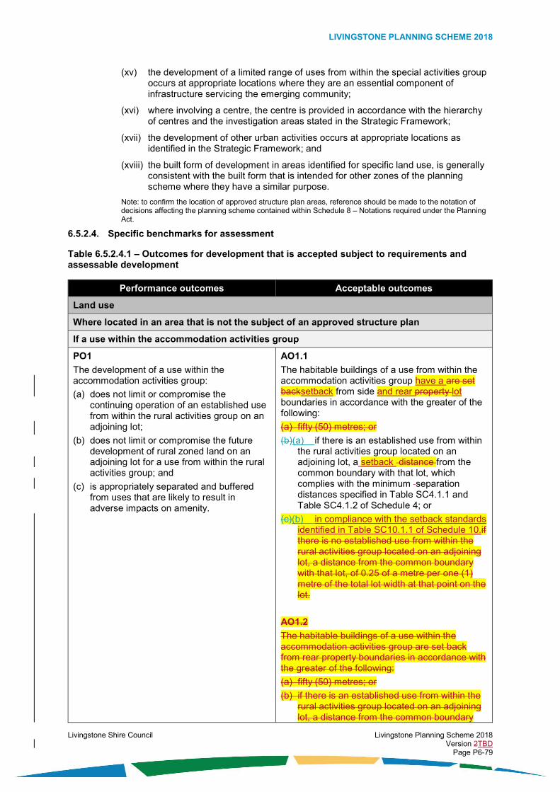
LIVINGSTONE PLANNING SCHEME 2018
Livingstone Shire Council Livingstone Planning Scheme 2018 Version 2TBD Page P6-79
(xv) the development of a limited range of uses from within the special activities group occurs at appropriate locations where they are an essential component of infrastructure servicing the emerging community;
(xvi) where involving a centre, the centre is provided in accordance with the hierarchy of centres and the investigation areas stated in the Strategic Framework;
(xvii) the development of other urban activities occurs at appropriate locations as identified in the Strategic Framework; and
(xviii) the built form of development in areas identified for specific land use, is generally consistent with the built form that is intended for other zones of the planning scheme where they have a similar purpose.
Note: to confirm the location of approved structure plan areas, reference should be made to the notation of decisions affecting the planning scheme contained within Schedule 8 – Notations required under the Planning Act.
6.5.2.4. Specific benchmarks for assessment
Table 6.5.2.4.1 – Outcomes for development that is accepted subject to requirements and assessable development
Performance outcomes Acceptable outcomes
Land use
Where located in an area that is not the subject of an approved structure plan
If a use within the accommodation activities group
PO1
The development of a use within the accommodation activities group:
(a) does not limit or compromise the continuing operation of an established use from within the rural activities group on an adjoining lot;
(b) does not limit or compromise the future development of rural zoned land on an adjoining lot for a use from within the rural activities group; and
(c) is appropriately separated and buffered from uses that are likely to result in adverse impacts on amenity.
AO1.1
The habitable buildings of a use from within the accommodation activities group have a are set backsetback from side and rear property lot boundaries in accordance with the greater of the following:
(a) fifty (50) metres; or
(b)(a) if there is an established use from within the rural activities group located on an adjoining lot, a setback distance from the common boundary with that lot, which complies with the minimum separation distances specified in Table SC4.1.1 and Table SC4.1.2 of Schedule 4; or
(c)(b) in compliance with the setback standards identified in Table SC10.1.1 of Schedule 10.if there is no established use from within the rural activities group located on an adjoining lot, a distance from the common boundary with that lot, of 0.25 of a metre per one (1) metre of the total lot width at that point on the lot.
AO1.2
The habitable buildings of a use within the accommodation activities group are set back from rear property boundaries in accordance with the greater of the following:
(a) fifty (50) metres; or
(b) if there is an established use from within the rural activities group located on an adjoining lot, a distance from the common boundary

LIVINGSTONE PLANNING SCHEME 2018
Livingstone Shire Council Livingstone Planning Scheme 2018 Version 2TBD Page P6-80
Performance outcomes Acceptable outcomes
with that lot, which complies with the minimum separation distances specified in Table SC4.1.1 and Table SC4.1.2 of Schedule 4; or
if there is no established use from within the rural activities group located on an adjoining lot, a distance from the common boundary with that lot, of 0.25 of a metre per one (1) metre of the total lot depth at that point on the lot.
AO1.32
The habitable buildings of a use within the accommodation activities group have a setback are set back from road frontage property lot boundaries in accordance with the greater of the following:
(a) twenty (20) metres; or
(a) if there is an established use from within the rural activities group located on a lot on the opposite side of the road, a distance setback from the road frontage lot boundary, which complies with the minimum separation distances specified in Table SC4.1.1 and Table SC4.1.2 of Schedule 4.; or
(b) in compliance with the setback standards identified in Table SC10.1.1 of Schedule 10.
If a use within the rural activities group
PO2
The development of a use within the rural activities group is designed, sited and operated to minimise significant adverse impacts on sensitive land use.
AO2.1
The development of a use within the rural activities group complies with the minimum separation distances specified in Table SC4.1.1 and Table SC4.1.2 of Schedule 4.
If a roadside stall
PO3
The roadside stall:
(a) is small in scale;
(b) does not impact on the amenity of adjoining land uses and the surrounding area;
(c) does not adversely affect the safety and efficiency of the road network;
(d) is ancillary to the rural use conducted on the same site; and
(e) sells only fresh produce grown locally.
AO3.1
Any structure used for a roadside stall:
(a) has a maximum floor area of twenty (20) square metres; and
(b) is located entirely within the property lot and not on the road reserve.
AO3.2
Site access, car parking and storage areas:
(a) are located entirely within the property lot and not on the road reserve; and
(b) use the same driveway as the primary property lot access.
Built form
Where located in an area that is not the subject of an approved structure plan
PO4 AO4.1

LIVINGSTONE PLANNING SCHEME 2018
Livingstone Shire Council Livingstone Planning Scheme 2018 Version 2TBD Page P6-81
Performance outcomes Acceptable outcomes
The height and bulk of buildings and structures are consistent with the intended character of the zone and do not adversely impact the character or amenity of the streetscape, adjoining sites and surrounding area.
Building height and the height of The height of buildings and structures does not exceed the following:
(a) two (2) storeys and 8.5 metres above ground level where the ground has a slope less than fifteen (15) per cent; or
(b) two (2) storeys and ten (10) metres above ground level where the ground has a slope equal to or greater than fifteen (15) per cent.
AO4.2
Site cover does not exceed fifty (50) per cent.
AO4.3
If located on a on a lot having an area 0 m2 to 2,999 m2, building height of a standalone Class 10a building under the Building Code of Australia, does not exceed the lesser of the following:
(a) if there is a dwelling house on the site, the height of the dwelling house; or
(b) five (5) metres to the apex of the Class 10a building.
AO4.4
If located on a on a lot having an area 0 m2 to 2,999 m2, the volume of a standalone Class 10a building under the Building Code of Australia, being a garage or shed, does not exceed three (3) per cent of the lot volume. Editor’s note: Lot volume is defined in SC1.2 Administrative definitions.
PO5
The design and siting of buildings and structures does not adversely impact the amenity of the streetscape or adjoining sites having regard to the following:
(a) minimisation of potential sources of nuisance;
(b) prevention of overshadowing of habitable buildings of any sensitive land use on adjoining lots; and
(c) prevention of overshadowing of public places.
AO5.1
Buildings and tallor structures (such as silos, windmills and the like) have a are setback from side, rear and road frontage property lot boundaries in compliance with the setback standards identified in Table SC10.1.1 of Schedule 10.accordance with the following:
for a building having a height up to and including 4.5 metres, a minimum setback of twenty (20) metres; or
for a building having a height greater than 4.5 metres, a minimum setback of twenty (20) metres plus 0.3 of a metre for every additional metre in height over 4.5 metres.
Table 6.5.2.4.2 — Additional outcomes for assessable development
Performance outcomes Acceptable outcomes
Land use
Where located in an area that is not the subject of an approved structure plan

LIVINGSTONE PLANNING SCHEME 2018
Livingstone Shire Council Livingstone Planning Scheme 2018 Version 2TBD Page P6-82
Performance outcomes Acceptable outcomes
PO6
If the development is for a use that is not consistent with Performance Outcome (PO7), the development does not occur within the zone until a structure plan has been approved by Council in accordance with the overall outcomes for the zone.
Editor’s note: For structure plans, other than the overall outcomes of this code, reference should also be made to Schedule SC7.14.
No acceptable outcome is nominated.
PO7
The use is only one of the following:
(a) a preferred use for the zone (as identified in the overall outcomes for the zone); or
(b) a use from within the special activities group where it is an essential component of infrastructure servicing the community (where in accordance with the circumstances identified in the overall outcomes for the zone).
No acceptable outcome is nominated.
PO8
The use does not limit or compromise the ability to develop the land for urban activities at a time when needed.
No acceptable outcome is nominated.
PO9
The use appropriately integrates with any established uses in the immediate area.
No acceptable outcome is nominated.
PO10
The use is located and designed in a manner that maintains public safety and minimises impacts on other land use.
No acceptable outcome is nominated.
PO11
The development of any public use that generates frequent and a large amount of public visitation:
(a) is highly accessible; and
(b) is well located in relation to public and active transport networks.
No acceptable outcome is nominated.
PO12
The development of a use within the rural activities group, where involving the boarding, accommodation, care, training, holding, keeping, production, or cultivation of animals and the like, ensures that the animals are confined within the site in secure fencing or other enclosures, and these confinements are sited, designed and managed in a manner which achieves the following:
(a) accepted best practice for the welfare of animals;
(b) prevention of the escape of animals;
No acceptable outcome is nominated.

LIVINGSTONE PLANNING SCHEME 2018
Livingstone Shire Council Livingstone Planning Scheme 2018 Version 2TBD Page P6-83
Performance outcomes Acceptable outcomes
(c) best practice for the hygienic confinement of animals; and
(d) minimal nuisance beyond the site boundaries by way of noise and odours produced by the animals.
PO13
The use does not result in land and water quality degradation (above ground and underground) due to the following:
(a) movement of sediment, nutrients, pathogens, and pollutants; or
(b) the handling, treatment and disposal of solid and liquid waste.
No acceptable outcome is nominated.
PO14
The use:
(a) avoids unnecessary clearing of native vegetation and habitat; and
(b) minimises major earthworks.
No acceptable outcome is nominated.
Lot size and shape
Where located in an area that is not the subject of an approved structure plan
PO15
The development does not reconfigure a lot into an inappropriate size which limits the potential to develop the land for urban activities in an efficient and coordinated manner.
Note: Council considers that lots below a minimum area of ten (10) hectares and a minimum lot frontage and lot width of two-hundred (200) metres are unsuitable for enhancing the potential to develop the land for urban activities in an efficient and coordinated manner.
No acceptable outcome is nominated.
Appearance
Where located in an area that is not the subject of an approved structure plan
PO16
The development is designed in a manner that does not significantly adversely affect visual amenity when viewed from the street, public places, and the surrounding area.
No acceptable outcome is nominated.
Infrastructure
Where located in an area that is not the subject of an approved structure plan
PO17
Safe, accessible, robust and reliable infrastructure relating to access and parking, energy supply, roads, roof and allotment drainage, sewage and wastewater treatment and disposal, stormwater management, telecommunications, and water supply, is adequately provided for the development in accordance with best practice and endorsed
AO17.1
The development complies with the requirements of the Development Works Code.

LIVINGSTONE PLANNING SCHEME 2018
Livingstone Shire Council Livingstone Planning Scheme 2018 Version 2TBD Page P6-84
Performance outcomes Acceptable outcomes
standards for the location, and relative to the needs of the development.
Structure Plan Area
Note: to confirm the location of approved structure plan areas, reference should be made to the notation of decisions affecting the planning scheme contained within Schedule 8 – Notations required under the Planning Act.

LIVINGSTONE PLANNING SCHEME 2018
Livingstone Shire Council Livingstone Planning Scheme 2018 Version 2TBD Page P6-85
6.5.3. Limited development zone code
6.5.3.1. Application
This code applies to the assessment of development if it is identified as an applicable code for development, as specified in the assessment benchmarks column in the tables of assessment located in Part 5 of the planning scheme.
When using this code, reference should be made to section 5.3.2 and where applicable, section 5.3.3 located in Part 5 of the planning scheme.
All subject matter in this code is applicable to the development assessment, unless the following circumstance arises:
(1) The heading of a specific benchmarks for assessment table specifies otherwise; or
(2) A heading within a specific benchmarks for assessment table specifies that the outcomes apply to a specific type of development or to development at a specific location; or
(3) A performance outcome or acceptable outcome specifies that the outcomes apply to a specific type of development or to development at a specific location.
In the circumstance where point (2) or point (3) above arises the following applies:
(1) the development assessment outcomes apply only to the type of development specified or only to development at the location specified; and
(2) the development must still be assessed against all other general subject matter of the code (for example, assessment benchmarks including but not limited to those relating to built form, appearance, or general land use).
6.5.3.2. Purpose
The purpose of the limited development zone code is:
(1) to limit development in identified areas of historical subdivision which are known to be significantly constrained due to their location and the absence of appropriate urban infrastructure and urban services;
(2) to limit development in other identified areas of land that are known to be significantly affected by one or more development constraints;
(3) to provide for the development of a limited range of rural activities as the preferred and dominant land use within the zone and a very limited range of other uses which are essential for the area; and
(4) to facilitate the achievement of the overall outcomes sought for the zone.
6.5.3.3. Overall outcomes
The purpose of the code will be achieved through the following overall outcomes:
(1) development (other than for a preferred use) does not occur in the zone;
(2) the development is a preferred use within the zone only in the following circumstances:
(a) if there are established sensitive land uses in immediate area, the use is small in scale and intensity and has low impacts; and
(b) the use:
(i) is animal husbandry; or
(ii) is cropping; or
(iii) is a park; or
(iv) is from within the special activities group and it has an essential and important role to support and service the needs of the immediate area or broader community; and
(3) the development:

LIVINGSTONE PLANNING SCHEME 2018
Livingstone Shire Council Livingstone Planning Scheme 2018 Version 2TBD Page P6-86
(a) does not require access to urban infrastructure and services;
(b) does not limit or compromise the development or expansion of a use from within the rural activities group at the site or in the immediate area; and
(c) does not result in the establishment of buildings and structures unless they are clearly associated with and necessary for a park, a use within the rural activities group, or a use within the special activities group undertaken at the site; and
(4) the development does not result in the establishment of any new uses from within the accommodation activities group, business activities group, community activities group, entertainment activities group, or industrial activities group; and
(5) development that is likely to have a high impact on land use in the immediate area does not occur;
(6) the development is compatible with a rural form that is characterised by:
(a) development on lots which have appropriate areas and dimensions relative to the quality and potential of the land to be developed for uses from within the rural activities group, particularly those involved in primary production;
(b) buildings and structures having a height designed relative to the operational needs of the use, characteristics of the location, and the surrounding land use;
(c) use of vegetation screening, separation distances and buffering to manage impacts between adjoining land use;
(7) the development maintains a reasonable level of visual amenity when viewed from the street and public places; and
(8) development maximises the potential to undertake uses from within the rural activities group by:
(a) not fragmenting land into small lot sizes below the minimum size and shape requirements specified in the reconfiguring a lot code; and
(b) amalgamating lots to create suitable sized rural lots in accordance with the minimum requirements specified in the reconfiguring a lot code.
6.5.3.4. Specific benchmarks for assessment
Table 6.5.3.4.1 – Outcomes for development that is accepted subject to requirements and assessable development
Performance outcomes Acceptable outcomes
Land use
PO1
The use is a preferred use for the zone (as identified in the overall outcomes for the zone).
No acceptable outcome is nominated.
PO2
The use: (a) is small in scale and has a limited intensity;
and (b) has low impacts on sensitive land use in
the immediate area.
No acceptable outcome is nominated.
PO3
A new use from within the accommodation activities group, business activities group, community activities group, entertainment activities group, or industrial activities group does not establish in the zone.
No acceptable outcome is nominated.

LIVINGSTONE PLANNING SCHEME 2018
Livingstone Shire Council Livingstone Planning Scheme 2018 Version 2TBD Page P6-87
Performance outcomes Acceptable outcomes
Built form
PO4
The development does not involve the construction of buildings and structures unless they are associated with and necessary for a park, a use within the rural activities group, or a use within the special activities group undertaken at the site.
No acceptable outcome is nominated.
PO5
If buildings and structures are associated with and necessary for a park, a use within the rural activities group, or a use within the special activities group undertaken at the site, the height of the buildings and structures are consistent with the rural character of the locality and the reasonable expectations as to the operational needs of the use, and they do not adversely impact the character or amenity of the streetscape, adjoining sites or the immediate area.
AO5.1
Building height The height of buildings does not exceed two (2) storeys and ten (10) metres above ground level (excluding silos and similar structures that are ancillary to the operations of a use within the rural activities group).
AO5.2
The height of structures does not exceed twenty-five (25) metres above ground level.
PO6
The design and siting of buildings and structures does not adversely impact the amenity of the streetscape or adjoining sites having regard to the following:
(a) minimisation of potential sources of nuisance; and
(b) provision of access to natural light and ventilation for habitable buildings of any sensitive land use on adjoining lots and for public places.
AO6.1
Buildings and or tall rural structures (such as silos and the like) have a setbackare set back from side, rear and road frontage property lot boundaries in accordance with the following:
(a) at any point where where the for a building or structure having a‘outermost projection height’ is between two (2) metres andup to and including 4.5 metres, a minimum setback of at least twenty (20) metres; or
(b) at any point where where the for a building or structure having a‘outermost projection height’ is greater than 4.5 metres, a minimum setback of at least twenty (20) metres plus 0.3 of a metre for every additional metre or part thereof in height over 4.5 metres.
Lot size and shape
PO7 Development does not involve the reconfiguration of a lot below the minimum size and shape requirements for lots specified in the reconfiguring a lot code.
No acceptable outcome is nominated.
Appearance
PO8 The development is designed in a manner that does not significantly adversely affect visual amenity when viewed from the street, public places, and the surrounding area.
No acceptable outcome is nominated.

LIVINGSTONE PLANNING SCHEME 2018
Livingstone Shire Council Livingstone Planning Scheme 2018 Version 2TBD Page P6-88

LIVINGSTONE PLANNING SCHEME 2018
Livingstone Shire Council Livingstone Planning Scheme 2018 Version 2TBD Page P6-89
6.5.4. Rural zone code
6.5.4.1. Application
This code applies to the assessment of development if it is identified as an applicable code for development, as specified in the assessment benchmarks column in the tables of assessment located in Part 5 of the planning scheme.
When using this code, reference should be made to section 5.3.2 and where applicable, section 5.3.3 located in Part 5 of the planning scheme.
All subject matter in this code is applicable to the development assessment, unless the following circumstance arises:
(1) The heading of a specific benchmarks for assessment table specifies otherwise; or
(2) A heading within a specific benchmarks for assessment table specifies that the outcomes apply to a specific type of development or to development at a specific location; or
(3) A performance outcome or acceptable outcome specifies that the outcomes apply to a specific type of development or to development at a specific location.
In the circumstance where point (2) or point (3) above arises the following applies:
(1) the development assessment outcomes apply only to the type of development specified or only to development at the location specified; and
(2) the development must still be assessed against all other general subject matter of the code (for example, assessment benchmarks including but not limited to those relating to built form, appearance, or general land use).
6.5.4.2. Purpose
The purpose of the rural zone code is:
(1) to identify the desired character and amenity for the zone and to protect it from incompatible development;
(2) to provide predominantly for a wide range of uses from within the rural activities group, particularly those involved primary production, and to protect these from land use conflict that may result from the development of sensitive land use and other non-rural uses;
(3) to protect or manage significant natural resources and processes to maintain the capacity for primary production;
(4) to provide for the development of a limited range of other uses that are compatible with rural areas and rural activities, where they do not limit or compromise the potential for the development of uses involved in primary production;
(5) to establish two precincts within the zone where particular development outcomes are specified, and the precincts are identified as follows:
(a) the Capricorn Coast Rural Precinct;
(b) the Yaamba Historic Township Precinct; and
(6) to facilitate the achievement of the overall outcomes sought for the zone.
6.5.4.3. Overall outcomes
The purpose of the code will be achieved through the following overall outcomes:
(1) the development is:
(a) a use within the rural activities group; or
(b) a use which:
(i) is compatible with and supports a use within the rural activities group; or
(ii) does not limit or compromise the development of a use within the rural activities group on an adjoining rural zoned lot;

LIVINGSTONE PLANNING SCHEME 2018
Livingstone Shire Council Livingstone Planning Scheme 2018 Version 2TBD Page P6-90
(2) the development of a use from within the rural activities group is a preferred use within the zone in the following circumstances:
(a) it is designed, sited and operated to mitigate significant adverse impacts on sensitive land use; and
(b) the use:
(i) is animal husbandry; or
(ii) is animal keeping; or
(iii) is aquaculture; or
(iv) is cropping; or
(v) is extractive industry; or
(vi) is intensive animal industry; or
(vii) is intensive horticulture; or
(viii) is a permanent plantation; or
(ix) is a roadside stall; or
(x) is a rural industry; or
(xi) is a wholesale nursery; or
(xii) is a winery; and
(3) the development of a use from within the accommodation activities group occurs within the zone only in the following circumstances:
(a) it is ancillary to the use of the land for a use within the rural activities group;
(b) it is designed and sited so as not to limit or compromise the continuing operation of an established use from within the rural activities group on an adjoining lot;
(c) it is designed and sited so as not to limit or compromise the future development of rural zoned land on an adjoining lot for a use from within the rural activities group;
(d) it is appropriately separated and buffered from uses that are likely to result in adverse impacts on amenity; and
(e) the use:
(i) is a caretaker’s accommodation; or
(ii) is a dwelling house; or
(iii) is a dwelling unit; or
(iv) is a home based business; or
(v) is rural worker’s accommodation;
(vi) is short-term accommodation (being a farm stay);
(4) the development of other non-rural uses occur within the zone only in the following circumstances:
(a) the use:
(i) is compatible with development in the immediate area; or
(ii) has characteristics which tie it to a specific natural resource; or
(iii) requires large area of land that is not available in an area zoned for urban activities; and
(b) it is designed and sited so as not to limit or compromise the continuing operation of an established use from within the rural activities group on an adjoining lot; and

LIVINGSTONE PLANNING SCHEME 2018
Livingstone Shire Council Livingstone Planning Scheme 2018 Version 2TBD Page P6-91
(c) it is designed and sited so as not to limit or compromise the future development of rural zoned land on an adjoining lot for a use from within the rural activities group; and
(d) it is designed, sited and operated to mitigate significant adverse impacts on sensitive land use; and
(e) it is located at a site adjoining an appropriate road in the planning scheme road hierarchy; and
(f) the use:
(i) is within the business activities group and is:
(A) bulk landscape supplies; or
(B) a garden centre; or
(C) veterinary services; or
(ii) is within the recreation activities group and is:
(A) an environment facility; or
(B) outdoor sport and recreation; or
(C) a park; or
(iii) is within the special activities group and is:
(A) is emergency services; or
(B) a landing; or
(C) a transport depot containing no more than four (4) vehicles; or
(D) other uses within the special activities group if they are an essential component of infrastructure servicing the community; and
(5) the development is compatible with a form that is characterised by:
(a) development on lots which have appropriate areas and dimensions relative to the quality and potential of the land to be developed for uses from within the rural activities group, particularly those involved in primary production;
(b) buildings and structures having a height designed relative to the operational needs of the use, characteristics of the location, and the surrounding land use;
(c) use of vegetation screening, separation distances and buffering to manage impacts between adjoining land use;
(d) protection of a reasonable level of visual amenity when viewed from the street and public places; and
(e) development being appropriately integrated with any large tracts and corridors of remnant vegetation and habitat, and any State or local significant vegetation, habitat, wetlands or waterways, so as to protect landscape values and natural environment values; and
(6) land that is identified as Agricultural Land Class A or Class B:
(a) is retained for development that is unlikely to limit or compromise the capacity of the land to be used for primary production;
(b) is protected from fragmentation due the creation of inappropriate lot sizes for the location;
(c) is protected from inappropriate and incompatible development, unless:
(i) there is a proven overriding need in terms of public benefit for the development and no other site is suitable for that particular development; or
(ii) the development is small-scale, has low impacts and is focussed on tourism which is directly associated with a rural activity undertaken on the site or involves

LIVINGSTONE PLANNING SCHEME 2018
Livingstone Shire Council Livingstone Planning Scheme 2018 Version 2TBD Page P6-92
education, promotion, or sales associated with primary produce sourced from the site or local area; or
(iii) the potential undertaking of agriculture on the subject land (alone or in association with surrounding land) is not practicable; and
(7) development maximises the potential to undertake uses from within the rural activities group by retaining lots in a suitable size and shape ((unless there is a demonstrated need adjacent to an identified township in accordance with Overall Outcome (7)(c) or if located in the Capricorn Coast Rural Precinct)) as specified in the minimum lot sizes and dimensions of the reconfiguration of a lot code and in this code as follows:
(a) a minimum area of sixty (60) hectares only where located upon land identified as being entirely within Agricultural Land Class A or Class B; or
(b) a minimum area of one-hundred and fifty (150) hectares where located upon land that is not as being entirely within Agricultural Land Class A or Class B;
(c) a minimum area of two (2) hectares where located adjacent to the township of Cawarral, Mount Chalmers, or The Caves, and all of the following circumstances exist:
(i) the site is not located within the Capricorn Coast Rural Precinct or is not located within land identified as Agricultural Land Class A or Class B; and
(ii) the site is not included in, or within five (5) kilometres of land designated as urban, new urban, or future urban as shown on the Strategic Framework maps; and
(iii) the new lots do not limit or compromise the continuing operation of an established use from within the rural activities group on an adjoining lot; and
(iv) it can be demonstrated that there is a need for additional supply of lots within a five (5) kilometre radius of the township zone; and
(v) the site is in proximity to primary school or a bus route; and
(vi) each new lot created has regular proportions; and
(vii) lots that adjoin rural zoned land are provided with adequate additional internal areas to provide separation and buffer areas; and
(viii) new lots do not take direct access from a State main road; and
(ix) a sufficient minimum number of lots is proposed in the one estate; and
(x) the land is capable of adequately providing for the on-site treatment and disposal of effluent and wastewater (where reticulated municipal sewerage is unavailable); and
(xi) the following infrastructure and services are provided:
(A) a bitumen sealed road of a suitable standard;
(B) approved municipal water supply; and
(C) electricity and telecommunications; and
(8) the development does not compromise the use of declared stock routes;
(9) the development is provided with adequate infrastructure and essential services; and
Where located in the Capricorn Coast Rural Precinct:
Note: The overall outcomes of the Capricorn Coast Rural Precinct are additional to those of the zone and take precedence in the event of a conflict.
(10) the precinct accommodates predominantly uses from within the rural activities group, particularly uses involved primary production which have relatively low impacts and can be undertaken on small rural lot sizes, and a limited range of non-rural uses where they are compatible with and support the rural uses in the precinct;
(11) the development of a use from within the rural activities group is a preferred use within the precinct in the following circumstances:

LIVINGSTONE PLANNING SCHEME 2018
Livingstone Shire Council Livingstone Planning Scheme 2018 Version 2TBD Page P6-93
(a) it is designed, sited and operated to mitigate significant adverse impacts on sensitive land use; and
(b) the use:
(i) is animal husbandry; or
(ii) is animal keeping; or
(iii) is aquaculture; or
(iv) is cropping; or
(v) is a roadside stall; or
(vi) is a rural industry; or
(vii) is a wholesale nursery; or
(viii) is a winery; and
(12) the development of intensive animal industry and intensive horticulture occur only if:
(a) the site has suitable area and proportions to accommodate the development in a manner which does not adversely affect adjoining land use;
(b) land is capable of adequately providing for the on-site treatment and disposal of effluent and wastewater in an environmentally responsible manner;
(c) water resources are available to sustain the development in an environmentally responsible manner; and
(d) it is designed, sited and operated so that there are no significant adverse impacts on sensitive land use;
(13) the following uses from within the rural activities group do not occur within the precinct:
(a) extractive industry, unless it is within an identified key resource area; or
(b) permanent plantation; and
(14) the development of a use from within the accommodation activities group or other non-rural uses occur in the precinct only if they are consistent with the circumstances identified in the overall outcomes for the zone in general; however, the exception to this is the development of a motor sport facility which is not preferred in the precinct; and
(15) development involving reconfiguration of lot occurs only if the resulting lots are a suitable size and shape to allow for the development of preferred uses within the precinct, as specified in the minimum lot sizes and dimensions of the reconfiguration of a lot code and in this code as follows:
(a) a minimum lot area of ten (10) hectares and a minimum lot width of two-hundred (200) metres; and
Where located in the Yaamba Historic Township Precinct:
Note: The overall outcomes of the Yaamba Historic Township Precinct are specific to this precinct and Overall Outcomes (1) to (9) for other areas in the rural zone as stated above do not apply within this precinct.
(16) development (other than for a preferred use for the Yaamba Historic Township Precinct) does not occur in the Yaamba Historic Township Precinct;
(17) the development is a preferred use within the Yaamba Historic Township Precinct only in the following circumstances:
(a) if there are established sensitive land use in the immediate area, the use is small in scale and intensity and has low impacts on sensitive land use; and
(b) the use:
(i) is animal husbandry; or
(ii) is cropping; or
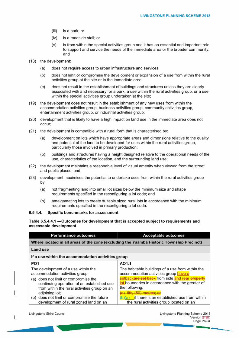
LIVINGSTONE PLANNING SCHEME 2018
Livingstone Shire Council Livingstone Planning Scheme 2018 Version 2TBD Page P6-94
(iii) is a park; or
(iv) is a roadside stall; or
(v) is from within the special activities group and it has an essential and important role to support and service the needs of the immediate area or the broader community; and
(18) the development:
(a) does not require access to urban infrastructure and services;
(b) does not limit or compromise the development or expansion of a use from within the rural activities group at the site or in the immediate area;
(c) does not result in the establishment of buildings and structures unless they are clearly associated with and necessary for a park, a use within the rural activities group, or a use within the special activities group undertaken at the site;
(19) the development does not result in the establishment of any new uses from within the accommodation activities group, business activities group, community activities group, entertainment activities group, or industrial activities group;
(20) development that is likely to have a high impact on land use in the immediate area does not occur;
(21) the development is compatible with a rural form that is characterised by:
(a) development on lots which have appropriate areas and dimensions relative to the quality and potential of the land to be developed for uses within the rural activities group, particularly those involved in primary production;
(b) buildings and structures having a height designed relative to the operational needs of the use, characteristics of the location, and the surrounding land use;
(22) the development maintains a reasonable level of visual amenity when viewed from the street and public places; and
(23) development maximises the potential to undertake uses from within the rural activities group by:
(a) not fragmenting land into small lot sizes below the minimum size and shape requirements specified in the reconfiguring a lot code; and
(b) amalgamating lots to create suitable sized rural lots in accordance with the minimum requirements specified in the reconfiguring a lot code.
6.5.4.4. Specific benchmarks for assessment
Table 6.5.4.4.1 —Outcomes for development that is accepted subject to requirements and assessable development
Performance outcomes Acceptable outcomes
Where located in all areas of the zone (excluding the Yaamba Historic Township Precinct)
Land use
If a use within the accommodation activities group
PO1 The development of a use within the accommodation activities group: (a) does not limit or compromise the
continuing operation of an established use from within the rural activities group on an adjoining lot;
(b) does not limit or compromise the future development of rural zoned land on an
AO1.1 The habitable buildings of a use from within the accommodation activities group have a setbackare set back from side and rear property lot boundaries in accordance with the greater of the following: (a) fifty (50) metres; or (b)(a) if there is an established use from within
the rural activities group located on an

LIVINGSTONE PLANNING SCHEME 2018
Livingstone Shire Council Livingstone Planning Scheme 2018 Version 2TBD Page P6-95
Performance outcomes Acceptable outcomes
adjoining lot for a use from within the rural activities group; and
(c) is appropriately separated and buffered from uses that are likely to result in adverse impacts on amenity.
adjoining lot, a distance setback from the common boundary with that lot, which complies with the minimum separation distances specified in Table SC4.1.1 and Table SC4.1.2 of Schedule 4; or
(c)(b) in compliance with the setback standards identified in Table SC10.1.1 of Schedule 10.if there is no established use from within the rural activities group located on an adjoining lot, a distance from the common boundary with that lot, of 0.25 of a metre per one (1) metre of the total lot width at that point on the lot.
AO1.2 The habitable buildings of a use within the accommodation activities group are set back from rear property boundaries in accordance with the greater of the following: (a) fifty (50) metres; or (b) if there is an established use from within the
rural activities group located on an adjoining lot, a distance from the common boundary with that lot, which complies with the minimum separation distances specified in Table SC4.1.1 and Table SC4.1.2 of Schedule 4; or
(c) if there is no established use from within the rural activities group located on an adjoining lot, a distance from the common boundary with that lot, of 0.25 of a metre per one (1) metre of the total lot depth at that point on the lot.
AO1.32 The habitable buildings of a use within the accommodation activities group have a setback are set back from road frontage property lot boundaries in accordance with the greater of the following: (a) twenty (20) metres; or (a) if there is an established use from within the
rural activities group located on a lot on the opposite side of the road, a distance from the road frontage boundary, which complies with the minimum separation distances specified in Table SC4.1.1 and Table SC4.1.2 of Schedule 4; or.
(b) in compliance with the setback standards identified in Table SC10.1.1 of Schedule 10.
If a use within the rural activities group
PO2
The development of a use within the rural activities group is designed, sited and operated
AO2.1
The development of a use within the rural activities group complies with the minimum
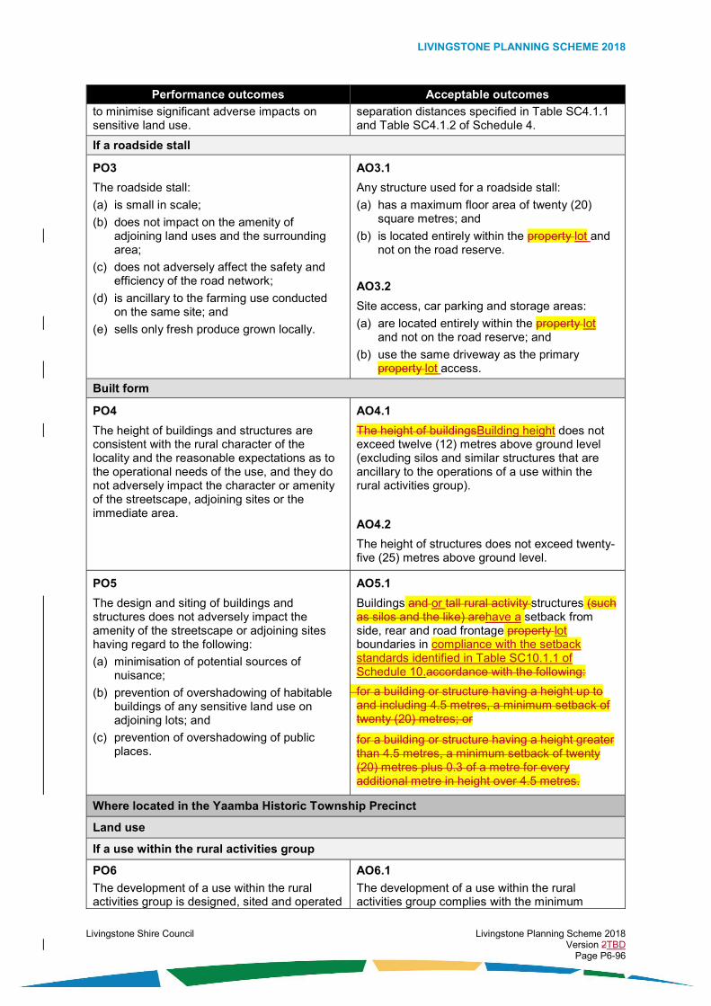
LIVINGSTONE PLANNING SCHEME 2018
Livingstone Shire Council Livingstone Planning Scheme 2018 Version 2TBD Page P6-96
Performance outcomes Acceptable outcomes
to minimise significant adverse impacts on sensitive land use.
separation distances specified in Table SC4.1.1 and Table SC4.1.2 of Schedule 4.
If a roadside stall
PO3
The roadside stall:
(a) is small in scale;
(b) does not impact on the amenity of adjoining land uses and the surrounding area;
(c) does not adversely affect the safety and efficiency of the road network;
(d) is ancillary to the farming use conducted on the same site; and
(e) sells only fresh produce grown locally.
AO3.1
Any structure used for a roadside stall:
(a) has a maximum floor area of twenty (20) square metres; and
(b) is located entirely within the property lot and not on the road reserve.
AO3.2
Site access, car parking and storage areas:
(a) are located entirely within the property lot and not on the road reserve; and
(b) use the same driveway as the primary property lot access.
Built form
PO4
The height of buildings and structures are consistent with the rural character of the locality and the reasonable expectations as to the operational needs of the use, and they do not adversely impact the character or amenity of the streetscape, adjoining sites or the immediate area.
AO4.1
The height of buildingsBuilding height does not exceed twelve (12) metres above ground level (excluding silos and similar structures that are ancillary to the operations of a use within the rural activities group).
AO4.2
The height of structures does not exceed twenty-five (25) metres above ground level.
PO5
The design and siting of buildings and structures does not adversely impact the amenity of the streetscape or adjoining sites having regard to the following:
(a) minimisation of potential sources of nuisance;
(b) prevention of overshadowing of habitable buildings of any sensitive land use on adjoining lots; and
(c) prevention of overshadowing of public places.
AO5.1
Buildings and or tall rural activity structures (such as silos and the like) arehave a setback from side, rear and road frontage property lot boundaries in compliance with the setback standards identified in Table SC10.1.1 of Schedule 10.accordance with the following:
for a building or structure having a height up to and including 4.5 metres, a minimum setback of twenty (20) metres; or
for a building or structure having a height greater than 4.5 metres, a minimum setback of twenty (20) metres plus 0.3 of a metre for every additional metre in height over 4.5 metres.
Where located in the Yaamba Historic Township Precinct
Land use
If a use within the rural activities group
PO6
The development of a use within the rural activities group is designed, sited and operated
AO6.1
The development of a use within the rural activities group complies with the minimum

LIVINGSTONE PLANNING SCHEME 2018
Livingstone Shire Council Livingstone Planning Scheme 2018 Version 2TBD Page P6-97
Performance outcomes Acceptable outcomes
to minimise significant adverse impacts on sensitive land use.
separation distances specified in Table SC4.1.1 and Table SC4.1.2 of Schedule 4.
If a roadside stall
PO7
The roadside stall:
(a) is small in scale;
(b) does not impact on the amenity of adjoining land uses and the surrounding area;
(c) does not adversely affect the safety and efficiency of the road network;
(d) is ancillary to the farming use conducted on the same site; and
(e) sells only fresh produce grown locally.
AO7.1
Any structure used for a roadside stall:
(a) has a maximum floor area of twenty (20) square metres; and
(b) is located entirely within the property lot and not on the road reserve.
AO7.2
Site access, car parking and storage areas:
(a) are located entirely within the property lot and not on the road reserve; and
(b) use the same driveway as the primary property lot access.
Built form
PO8
The development does not result in the intensification of buildings and structures in the precinct unless they are associated with and necessary for preferred uses for the precinct.
AO8.1
The development does not involve the construction of buildings and structures unless they are associated with and necessary for:
(a) a park; or
(b) a use within the rural activities group; or
(c) a use within the special activities group undertaken at the site.
PO9
If buildings and structures are associated with and necessary for a park, a use within the rural activities group, or a use within the special activities group undertaken at the site, the height of the buildings and structures are consistent with the rural character of the locality and the reasonable expectations as to the operational needs of the use, and they do not adversely impact the character or amenity of the streetscape, adjoining sites or the immediate area.
AO9.1
The height of buildingsBuilding height does not exceed two (2) storeys and ten (10) metres above ground level (excluding silos and similar structures that are ancillary to the operations of a use within the rural activities group).
AO9.2
The height of structures does not exceed twenty-five (25) metres above ground level.
PO10
The design and siting of buildings and structures does not adversely impact the amenity of the streetscape or adjoining sites having regard to the following:
(a) minimisation of potential sources of nuisance; and
(b) provision of access to natural light and ventilation for habitable buildings of any sensitive land use on adjoining lots and for public places.
AO10.1
Buildings and or tall rural structures (such as silos and the like) have a setback are set back from side, rear and road frontage property lot boundaries in accordance with the following:
(a) at any point where the for a building or structure having a‘outermost projection height’ is between two (2) metresup to and including 4.5 metres, a minimum setback of at least twenty (20) metres; or
(b) at any point where the for a building or structure having a‘outermost projection height’ is greater than 4.5 metres, a minimum

LIVINGSTONE PLANNING SCHEME 2018
Livingstone Shire Council Livingstone Planning Scheme 2018 Version 2TBD Page P6-98
Performance outcomes Acceptable outcomes
setback of at least twenty (20) metres plus 0.3 of a metre for every additional metre or part thereof in height over 4.5 metres.
Table 6.5.4.4.2 — Additional outcomes for assessable development
Performance outcomes Acceptable outcomes
Where located in all areas of the zone (excluding the Capricorn Coast Rural Precinct and excluding the Yaamba Historic Township Precinct)
Land use
PO11
The use contributes to the development of the rural zone which is comprised of the following:
(a) preferred uses for the zone (as identified in the overall outcomes for the zone); or
(b) uses within the accommodation activities group (where in accordance with the circumstances identified in the overall outcomes for the zone); or
(c) other uses that are not within the rural activities group or accommodation activities group (where in accordance with the circumstances identified in the overall outcomes for the zone).
No acceptable outcome is nominated.
Where located in the Capricorn Coast Rural Precinct
Land use
PO12
The use contributes to the development of a Capricorn Coast Rural Precinct which is comprised of the following:
(a) preferred uses for the precinct (as identified in the overall outcomes for the zone); or
(b) intensive animal industry or intensive horticulture (where in accordance with the circumstances identified in the overall outcomes for the precinct); or
(c) a use from within the accommodation activities group or other non-rural uses (where in accordance with the circumstances identified in the overall outcomes for the precinct).
No acceptable outcome is nominated.
Where located in the Yaamba Historic Township Precinct
Land use
PO13
The use is a preferred use for the precinct (as identified in the overall outcomes for the precinct).
No acceptable outcome is nominated.
PO14
The use:
No acceptable outcome is nominated.

LIVINGSTONE PLANNING SCHEME 2018
Livingstone Shire Council Livingstone Planning Scheme 2018 Version 2TBD Page P6-99
Performance outcomes Acceptable outcomes
(a) is small in scale and has a limited intensity; and
(b) has low impacts on sensitive land use in the immediate area.
PO15
A new use from within the accommodation activities group, business activities group, community activities group, entertainment activities group, or industrial activities group does not establish in the zone.
No acceptable outcome is nominated.
Where located in all areas of the zone (excluding the Yaamba Historic Township Precinct)
PO16
The development of a use within the rural activities group is designed and operated at an appropriate scale and intensity relative to the capacity of water resources and soil to sustain the development activity in an environmentally responsible manner.
No acceptable outcome is nominated.
PO17
The development of a use within the rural activities group or a use being veterinary services, where involving the boarding, accommodation, care, training, holding, keeping, production, or cultivation of animals and the like, ensures that the animals are confined within the site in secure fencing or other enclosures, and these confinements are sited, designed and managed in a manner which achieves the following:
(a) accepted best practice for the welfare of animals;
(b) prevention of the escape of animals;
(c) best practice for the hygienic confinement of animals; and
(d) minimal nuisance beyond the site boundaries by way of noise and odours produced by the animals.
No acceptable outcome is nominated.
PO18
The use does not result in land and water quality degradation (above ground and underground) due to the following:
(a) movement of sediment, nutrients, pathogens, and pollutants; or
(b) the handling, treatment and disposal of solid and liquid waste.
No acceptable outcome is nominated.
PO19
The use:
No acceptable outcome is nominated.

LIVINGSTONE PLANNING SCHEME 2018
Livingstone Shire Council Livingstone Planning Scheme 2018 Version 2TBD Page P6-100
Performance outcomes Acceptable outcomes
(a) avoids unnecessary clearing of native vegetation and habitat; and
(b) minimises major earthworks.
If an extractive industry
PO20
To the extent practicable, scarred areas of the natural landscape resulting from extractive industry are screened from view of public roads, prominent public viewer places and neighbouring properties.
AO20.1
A densely vegetated buffer area having a minimum depth from the property lot boundary of twenty (20) metres is located along all boundaries of the site (excluding access points), and the buffer area contains vegetation having a foliage height and density capable of visually screening scarred areas of land when viewed from public roads, prominent public viewer places and neighbouring properties.
PO21
Rehabilitation of the site occurs over the life of the project and the development is undertaken in accordance with a management plan which satisfies Council that premises that will be safe and useable upon completion and the following actions will be appropriately undertaken:
(a) progressive rehabilitation works at the site;
(b) appropriate clean-up works (including areas of possible soil or water contamination);
(c) provision of stable and usable final landform and soil profiles; and
(d) revegetation of the site using suitable native species.
No acceptable outcome is nominated.
PO22
Noise generating activities occur at times that are unlikely to result in unreasonable disturbance to sensitive land use.
AO22.1
Significant noise generating activities such as blasting, crushing, grinding, milling, loading or similar only occur between the hours of 9:00 and 17:00.
AO22.2
Noise generating activities (other than those listed in AO22.1) only occur between the hours of 06:00 and 18:00.
If a transport depot
PO23
Development for the purpose of a transport depot:
(a) is located at an appropriate sized site;
(b) is ancillary to the use of the site primarily for rural purposes;
(c) is small in scale;
(d) is designed and sited to minimise adverse impacts on the amenity of any sensitive land use in the immediate area;
AO23.1
The transport depot does not store any more than four (4) vehicles.
AO23.2
The transport depot:
(a) is situated a minimum distance of fifty (50) metres from a side or rear property lot boundary;

LIVINGSTONE PLANNING SCHEME 2018
Livingstone Shire Council Livingstone Planning Scheme 2018 Version 2TBD Page P6-101
Performance outcomes Acceptable outcomes
(e) does not result in a significant amount of daily vehicle trips to and from the site; and
(f) is located at a site adjoining an appropriate road in the planning scheme road hierarchy in order to:
(i) minimise disturbance to adjoining land use from dust and vehicle noise;
(ii) minimise costly damage to the road surface; and
(iii) minimise any adverse impacts to the safety, efficiency and effectiveness of the road network.
(b) is situated a minimum distance of fifty (50) metres from a road frontage property lot boundary;
(c) is situated a minimum distance of 150 metres from a sensitive land use located on an adjoining site; and
(d) is within a garage.
AO23.3
Any maintenance of vehicles:
(a) is minor in nature;
(b) does not involve major body work; and
(c) does not involve major engine or mechanical repairs.
AO23.4
The transport depot is located at a site which gains access from a road having the following characteristics:
(a) the road is bitumen sealed; and
(b) the road is not classified in the road hierarchy as an access street or an access place.
Where located within Agricultural Land Class A and Class B identified on an overlay
PO24
Land that is identified as Agricultural Land Class A or Class B is developed only in the following circumstances:
(a) it is for a land use from within the rural activities group, which does not limit or compromise the capacity of the land to be used for primary production; or
(b) it is for a land use that is not within the rural activities group, which is not irreversible, and which does not limit or compromise the capacity of the land to be used for primary production; or
(c) it is proven that the land should not actually be identified as Agricultural Land Class A or Class B; or
(d) other than in the Capricorn Coast Rural Precinct, it does not result in the creation of a lot having an area less than sixty (60) hectares and a width less than 450 metres; or
(e) it is for a land use that is not within the rural activities group and there is an overriding need in terms of public benefit for the development and that the development cannot be located on alternative sites that are suitable for the development; or
No acceptable outcome is nominated.

LIVINGSTONE PLANNING SCHEME 2018
Livingstone Shire Council Livingstone Planning Scheme 2018 Version 2TBD Page P6-102
Performance outcomes Acceptable outcomes
(f) the land is identified as Key Resource Area; or
(g) the development is small-scale, has low impacts and is focussed on tourism which is directly associated with a rural activity undertaken on the site or involves education, promotion, or sales associated with primary produce sourced from the site or local area; or
(h) the potential undertaking of agriculture on the subject land (alone or in association with surrounding land) is not practicable.
Where located adjacent to the township of Cawarral, Mount Chalmers, or The Caves
PO25
Reconfiguration of rural zoned lots located adjacent to the townships of Cawarral, Mount Chalmers or The Caves only occurs when all of the following circumstances exist:
(a) the site is not located within the Capricorn Coast Rural Precinct or is not located within Agricultural Land Class A or Class B land;
(b) the site is not included in, or within five (5) kilometres of land designated as urban, new urban, or future urban as shown on the Strategic Framework maps;
(c) the new lots do not limit or compromise the continuing operation of an established use from within the rural activities group on an adjoining lot;
(d) it can be demonstrated that there are fewer than ten (10) existing vacant lots, which have areas of between one (1) and three (3) hectares in extent, within a five (5) kilometre radius of the township zone;
(e) the site is within ten (10) kilometres of a primary school or within one (1) kilometre of a school bus route;
(f) the site is within ten (10) kilometres of an existing useable hall or other acceptable meeting place such as a shop or sporting facility;
(g) each new lot created has regular proportions and is not smaller than two (2) hectares in area and eighty (80) metres in width;
(h) lots that adjoin rural zoned land are provided with adequate additional internal areas to provide separation and buffers between any established or future use of adjoining lots for rural activities and any future sensitive land use on the new low lot;
(i) new lots do not take direct access from a State main road;
No acceptable outcome is nominated.

LIVINGSTONE PLANNING SCHEME 2018
Livingstone Shire Council Livingstone Planning Scheme 2018 Version 2TBD Page P6-103
Performance outcomes Acceptable outcomes
(j) a minimum of twenty (20) new lots is proposed in one estate;
(k) the land is capable of adequately providing for the on-site treatment and disposal of effluent and wastewater (where reticulated municipal sewerage is unavailable); and
(l) the following infrastructure and services are provided:
(i) a bitumen sealed road to rural standard or higher;
(ii) municipal water supply; and
(iii) electricity and telecommunications.
Appearance
PO26
The development is designed in a manner that does not significantly adversely affect visual amenity when viewed from the street, public places, and the surrounding area.
No acceptable outcome is nominated.
Stock routes
PO27
The development does not limit or compromise the use of identified stock routes for stock movement or other compatible uses.
No acceptable outcome is nominated.
Infrastructure
PO28
Safe, accessible, robust and reliable infrastructure relating to access and parking, energy supply, roads, roof and allotment drainage, sewage and wastewater treatment and disposal, stormwater management, telecommunications, and water supply, is adequately provided for the development in accordance with best practice and endorsed standards for the location, and relative to the needs of the development.
AO28.1
The development complies with the requirements of the Development Works Code.
Where located in the Yaamba Historic Township Precinct
Lot size and shape
PO29
Development does not involve the reconfiguration of a lot below the minimum size and shape requirements for lots specified in the reconfiguring a lot code.
No acceptable outcome is nominated.
Appearance
PO30
The development is designed in a manner that does not significantly adversely affect visual amenity when viewed from the street, public places, and the surrounding area.
No acceptable outcome is nominated.

LIVINGSTONE PLANNING SCHEME 2018
Livingstone Shire Council Livingstone Planning Scheme 2018 Version 2TBD Page P6-104

LIVINGSTONE PLANNING SCHEME 2018
Livingstone Shire Council Livingstone Planning Scheme 2018 Version 2TBD Page P6-105
6.5.5. Rural residential zone code
6.5.5.1. Application
This code applies to the assessment of development if it is identified as an applicable code for development, as specified in the assessment benchmarks column in the tables of assessment located in Part 5 of the planning scheme.
When using this code, reference should be made to section 5.3.2 and where applicable, section 5.3.3 located in Part 5 of the planning scheme.
All subject matter in this code is applicable to the development assessment, unless the following circumstance arises:
(1) The heading of a specific benchmarks for assessment table specifies otherwise; or
(2) A heading within a specific benchmarks for assessment table specifies that the outcomes apply to a specific type of development or to development at a specific location; or
(3) A performance outcome or acceptable outcome specifies that the outcomes apply to a specific type of development or to development at a specific location.
In the circumstance where point (2) or point (3) above arises the following applies:
(1) the development assessment outcomes apply only to the type of development specified or only to development at the location specified; and
(2) the development must still be assessed against all other general subject matter of the code (for example, assessment benchmarks including but not limited to those relating to built form, appearance, or general land use).
6.5.5.2. Purpose
The purpose of the rural residential zone code is:
(1) to identify the desired character and amenity for the zone and to protect it from incompatible development;
(2) to provide for the development of clusters of dwelling houses on small rural lots, located in a rural setting or in close proximity to a rural township;
(3) to provide for the development of a limited range of low-impact non-residential uses only if they are compatible with and support the needs of residents of the local catchment area;
(4) to establish one precinct within the zone where particular development outcomes are specified, and the precinct is identified as follows:
(a) the Park Residential Precinct; and
(5) to facilitate the achievement of the overall outcomes sought for the zone.
6.5.5.3. Overall outcomes
The purpose of the code will be achieved through the following overall outcomes:
(1) the development is:
(a) a use within the accommodation activities group which:
(i) provides only for the long-term stay of residents;
(ii) is designed at a low dwelling density; and
(iii) is designed to be consistent with the character of a rural residential setting which is predominantly comprised of detached dwellings and small scale low-impact rural activities; or
(b) a use which supports the residential dwellings of the immediate area; and
(2) the development of a use within the accommodation activities group is a preferred use within the zone in the following circumstances:

LIVINGSTONE PLANNING SCHEME 2018
Livingstone Shire Council Livingstone Planning Scheme 2018 Version 2TBD Page P6-106
(a) it is designed and sited to mitigate impacts from nearby rural activities; and
(b) the use: (i) is a caretaker’s accommodation; or
(ii) is a community residence; or
(iii) is a dwelling house; or
(iv) is a home based business and it complies strictly with specified design, siting, and operational requirements; and
(3) the development of a use within the rural activities group occurs within the zone only in the following circumstances:
(a) the site has sufficient size;
(b) it is domestic in scale;
(c) it has low impacts and is does not significantly disturb neighbouring sensitive land use; and
(d) the use:
(i) is animal husbandry; or
(ii) is cropping; or
(iii) is a wholesale nursery.
(4) the development of a use that is not within the accommodation activities group or rural activities group occurs within the zone only in the following circumstances:
(a) it is small in scale;
(b) it is consistent with the built form and appearance of development in the immediate surrounding area;
(c) it is located at a site adjoining an appropriate road in the planning scheme road hierarchy; and
(d) the use:
(i) is an environment facility; or
(ii) is a park; or
(iii) is a sales office; or
(iv) is a transport depot; or
(v) is within the special activities group and it is an essential component of infrastructure servicing the community; and
(5) development that is likely to have a high impact on sensitive land use does not occur within the zone;
(6) development contributes to a high level of amenity and an attractive living environment;
(7) sensitive land use is not located in proximity to any established incompatible uses without appropriate design and siting to minimise adverse impacts on amenity;
(8) the development is compatible with a rural residential form that is characterised by:
(a) a low ‘net’ dwelling density (dwellings located on large lots predominantly having an area of two (2) hectares or greater);
(b) substantial private open space and landscaping;
(c) reasonable separation of buildings from property lot boundaries;
(d) appealing streetscapes and public places; and
(9) the appearance of development provides visual interest and contributes to a high level of visual amenity when viewed from the street, public places, and the surrounding area;

LIVINGSTONE PLANNING SCHEME 2018
Livingstone Shire Council Livingstone Planning Scheme 2018 Version 2TBD Page P6-107
(10) the development is provided with adequate infrastructure and essential services; and
Where located in the Park Residential Precinct:
Note: The overall outcomes of the Park Residential Precinct are additional to those of the zone and take precedence in the event of a conflict.
(11) the precinct accommodates primarily residential uses located in a rural or peri-urban setting and provides for a limited range of non-residential uses;
(12) the development is:
(a) a use within the accommodation activities group which provides for the long-term stay of residents; or
(b) a use which supports the residential dwellings of the immediate area; and
(13) the development of a use within the accommodation activities group is a preferred use within the precinct in the following circumstances:
(a) it is designed and sited to mitigate impacts from nearby rural activities; and
(b) the use: (i) is a caretaker’s accommodation; or
(ii) is a community residence; or
(iii) is a dwelling house; or
(iv) is a home based business and it complies strictly with specified design, siting, and operational requirements; and
(14) the development of a use that is not within the accommodation activities group occurs within the precinct only in the following circumstances:
(a) it is small in scale;
(b) it is consistent with the built form and appearance of development in the immediate surrounding area;
(c) it is located at a site adjoining an appropriate road in the planning scheme road hierarchy; and
(d) the use:
(i) is an environment facility; or
(ii) is a park; or
(iii) is a sales office; or
(iv) is within the special activities group and it is an essential component of infrastructure servicing the community; or
(15) the development of a use within the rural activities group does not occur within the precinct;
(16) the development is compatible with a form that is characterised by:
(a) a low ‘net’ dwelling density (dwellings located on large lots predominantly having an area of four thousand (4000) square metres or greater);
(b) substantial private open space and landscaping;
(c) reasonable separation of buildings from property lot boundaries; and
(d) appealing streetscapes and public places.
6.5.5.4. Specific benchmarks for assessment
Table 6.5.5.4.1 – Outcomes for development that is accepted subject to requirements and assessable development

LIVINGSTONE PLANNING SCHEME 2018
Livingstone Shire Council Livingstone Planning Scheme 2018 Version 2TBD Page P6-108
Performance outcomes Acceptable outcomes
Dwelling density
PO1
The development of a use from within the accommodation activities group is designed in a manner that is compatible with the following:
(a) the planned low dwelling density for the zone or precinct; and
(b) the ability of the land and infrastructure to support the development.
AO1.1
The dwelling density (not including where a dwelling house has an ancillary secondary dwelling) does not exceed the following:
(a) if located in the Park Residential Precinct: one dwelling for every 4000 square metres of site area; or
(b) if located elsewhere in the zone: one dwelling for every two (2) hectares of site area.
Built form
PO2
The height, bulk, and site cover of buildings and structures are consistent with the intended character of the zone and do not adversely impact the character or amenity of the streetscape, adjoining sites and surrounding area.
AO2.1
Building height and the height of The height of buildings and structures does not exceed the following:
(a) two (2) storeys and 8.5 metres above ground level where the ground has a slope less than fifteen (15) per cent; or
(b) two (2) storeys and ten (10) metres above ground level where the ground has a slope equal to or greater than fifteen (15) per cent.
AO2.2
Site cover does not exceed fifty (50) per cent.
PO3
The design and siting of buildings and structures results in a high level of on-site amenity and does not adversely impact the character or amenity of the streetscape, adjoining sites, or the rural setting having regard to the following:
(a) minimisation of potential sources of nuisance;
(b) provision of adequate separation between buildings on neighbouring sites;
(c) provision of access to natural light and ventilation;
(d) the privacy of any dwellings located on adjoining sites.
AO3.1
Buildings or structures have a setback are set back from from side, rear and road frontage property lot boundaries in compliance with the setback standards identified in Table SC10.1.4 of Schedule 10.in accordance with the following:
(a) garages are set back a minimum of ten (10) metres;
(b) a standalone class 10a building under the Building Code of Australia being a garage or shed, is set back a minimum of ten (10) metres; and
a dwelling is set back a minimum of ten (10) metres.
AO3.2
Buildings are set back from side and rear property boundaries in accordance with the following:
(a) if located in the Park Residential Precinct:
(i) for a building or structure having a height up to and including 4.5 metres, there is a minimum setback of five (5) metres; or
(ii) for a building or structure having a height greater than 4.5 metres, there is a minimum setback of five (5) metres plus

LIVINGSTONE PLANNING SCHEME 2018
Livingstone Shire Council Livingstone Planning Scheme 2018 Version 2TBD Page P6-109
Performance outcomes Acceptable outcomes
0.3 of a metre for every additional metre in height over 4.5 metres; or
(b) if located elsewhere in the zone:
(i) for a building or structure having a height up to and including 4.5 metres, there is a minimum setback of ten (10) metres; or
(ii) for a building or structure having a height greater than 4.5 metres, there is a minimum setback of ten (10) metres plus 0.3 of a metre for every additional metre in height over 4.5 metres.
AO3.32
If the distance separating a window of a habitable room or a balcony or a patio is less than three (3) metres at ground level or nine (9) metres at levels above the ground level storey, of a window of a habitable room or a balcony or a patio of an adjacent building, privacy is protected by utilising the following:
(a) window sill heights a minimum of 1.5 metres above floor level; or
(b) fixed opaque glazing in any part of the window below 1.5 metres above floor level; or
(c) fixed external screens; or
(d) in the case of screening for a ground floor level, fencing to a height of 1.5 metres above ground floor level.
Table 6.5.5.4.2 – Additional outcomes for assessable development
Performance outcomes Acceptable outcomes
Land use
PO4
The use contributes to the development of rural residential communities which:
(a) comprise preferred uses for the zone (as identified in the overall outcomes for the zone); or
(b) comprise other small-scale relatively low-impact uses identified in the overall outcomes for the zone that are not within the accommodation activities group or rural activities group , where they service the community needs of the immediate rural residential area.
No acceptable outcome is nominated.
PO5
The use contributes to a high level of amenity and an attractive living environment for residents in the immediate area.
No acceptable outcome is nominated.
PO6 No acceptable outcome is nominated.

LIVINGSTONE PLANNING SCHEME 2018
Livingstone Shire Council Livingstone Planning Scheme 2018 Version 2TBD Page P6-110
Performance outcomes Acceptable outcomes
The use appropriately integrates with any established uses in the immediate area.
If animal husbandry
PO7
Development for the purpose of animal husbandry:
(a) is located at an appropriate sized site;
(b) is ancillary to the use of the site primarily for residential purposes;
(c) is small and domestic in scale; and
(d) is designed and sited to minimise adverse impacts on the amenity of sensitive land use in the immediate area.
AO7.1
Development for the purpose of animal husbandry is located in accordance with the following:
(a) it is not within the Park Residential Precinct; and
(b) it is not on any lot having dimensions of less than two (2) hectares in area and a lot width less than eighty (80) metres.
AO7.2
The development does not involve buildings and structures associated with the storage, handling, packaging or processing of animal product or by-product, unless they can be sited in compliance with the minimum separation distances specified in Table SC4.1.1 of Schedule 4.
AO7.3
The site has sufficient area to ensure that any rural sources of conflict associated with the use comply with the minimum separation distances specified in Table SC4.1.2 of Schedule 4.
AO7.4
Any confinement or enclosure areas associated with the animal husbandry are not sited within thirty (30) metres of a sensitive land use located on an adjoining lot.
AO7.5
The animal husbandry does not conflict with the circumstance and maximum stocking density specified in Table 6.5.5.4.2.1.
Table 6.5.5.4.2.1 – Maximum stocking density for animal husbandry in rural residential zones
Circumstance Animal Group Maximum Stocking Density
If the animal husbandry only involves animals from Group A
Group A:
Ass; or
Donkey; or
Mule; or
Horse; or
Camel; or
Llama; or
Cattle.
The maximum stocking density for any individual animal or combination of the animals in Group A does not exceed one (1) per Hectare of lot area

LIVINGSTONE PLANNING SCHEME 2018
Livingstone Shire Council Livingstone Planning Scheme 2018 Version 2TBD Page P6-111
Performance outcomes Acceptable outcomes
If the animal husbandry only involves animals from Group B
Group B:
Goat; or
Sheep; or
Other caprines that are similar in nature to a goat or sheep; or
Alpaca; or
Pig.
The maximum stocking density for any individual animal or combination of the animals in Group B does not exceed three (3) per Hectare of lot area
If the animal husbandry only involves animals from Group C
Group C:
Emu; or
Ostrich; or
Other flightless birds.
The maximum stocking density for any individual animal or combination of the animals in Group C does not exceed sixteen (16) per Hectare of lot area
If the animal husbandry only involves animals from Group D
Group D:
Birds (other than listed in group C).
Fifty (50) per hectare of lot area
If the animal husbandry involves a combination of animals from Group A, Group B, Group C or Group D
Animals from Group A, Group B, Group C or Group D
The maximum stocking density does not exceed any proportional combination of the stocking densities corresponding to each of the groups.
PO8
Development for the purpose of animal husbandry, ensures that the animals are confined within the site in secure fencing or other enclosures, and these confinements are sited, designed and managed in a manner which achieves the following:
(a) accepted best practice for the welfare of animals;
(b) prevention of the escape of animals;
(c) best practice for the hygienic confinement of animals; and
(d) minimal nuisance beyond the site boundaries by way of emissions including but not limited to noise and odours produced by the animals.
No acceptable outcome is nominated.
If cropping
PO9
Development for the purpose of cropping:
(a) is located at an appropriate sized site;
(b) is ancillary to the use of the site primarily for residential purposes;
(c) is small and domestic in scale; and
(d) is designed and sited to minimise adverse impacts on the amenity of sensitive land use in the immediate area.
AO9.1
Development for the purpose of cropping is located in accordance with the following:
(a) it is not within the Park Residential Precinct; and
(b) it is not on any lot having dimensions of less than two (2) hectares in area and a lot width less than eighty (80) metres.
AO9.2

LIVINGSTONE PLANNING SCHEME 2018
Livingstone Shire Council Livingstone Planning Scheme 2018 Version 2TBD Page P6-112
Performance outcomes Acceptable outcomes
The development does not involve buildings and structures associated with the storage, handling, packaging or processing of cropping produce, unless they can be sited in compliance with the minimum separation distances specified in Table SC4.1.1 of Schedule 4.
AO9.3
The site has sufficient area to ensure that any rural sources of conflict associated with the use comply with the minimum separation distances specified in Table SC4.1.2 of Schedule 4.
If a wholesale nursery
PO10
Development for the purpose of a wholesale nursery:
(a) is located at an appropriate sized site;
(b) is ancillary to the use of the site primarily for residential purposes;
(c) is small and domestic in scale; and
(d) is designed and sited to minimise adverse impacts on the amenity of sensitive land use in the immediate area.
AO10.1
Development for the purpose of a wholesale nursery is located in accordance with the following:
(a) it is not within the Park Residential Precinct; and
(b) it is not on any lot having dimensions of less than two (2) hectares in area and a lot width less than eighty (80) metres.
AO10.2
Buildings and structures associated with the wholesale nursery are sited in compliance with the minimum separation distances specified in Table SC4.1.1 of Schedule 4.
AO10.3
The site has sufficient area to ensure that any rural sources of conflict associated with the use comply with the minimum separation distances specified in Table SC4.1.2 of Schedule 4.
If a transport depot
PO11
Development for the purpose of a transport depot:
(a) is located at an appropriate sized site;
(b) is ancillary to the use of the site primarily for residential purposes;
(c) is small and domestic in scale;
(d) is integrated with a dwelling house on the site;
(e) is designed and sited to minimise adverse impacts on the amenity of sensitive land use in the immediate area; and
(f) is located at a site adjoining an appropriate road in the planning scheme road hierarchy in order to:
AO11.1
Development for the purpose of a transport depot is located in accordance with the following:
(a) it is not within the Park Residential Precinct; and
(b) it is not on any lot having dimensions of less than two (2) hectares in area and a lot width less than eighty (80) metres.
AO11.2
The transport depot does not establish or operate until such time as a dwelling house is established at the premises.
AO11.3
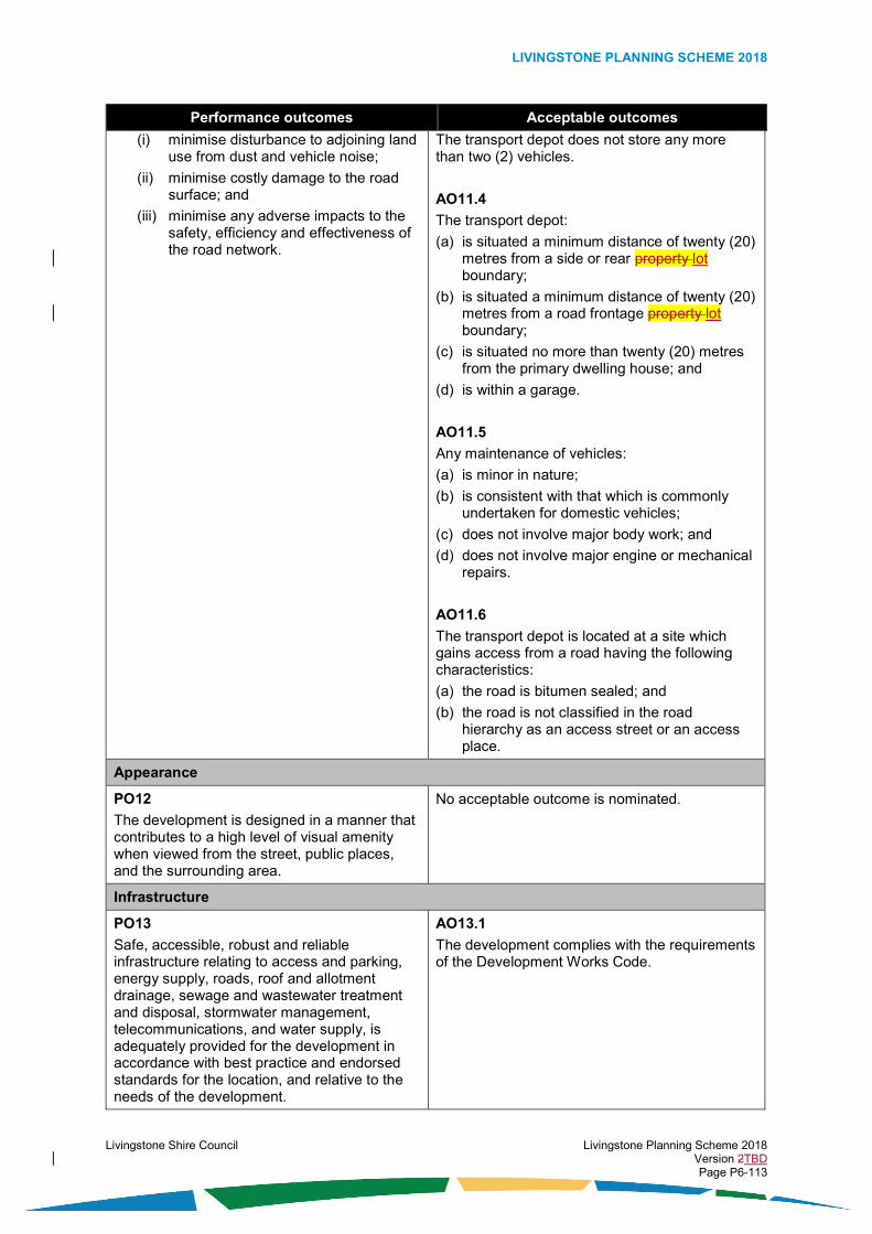
LIVINGSTONE PLANNING SCHEME 2018
Livingstone Shire Council Livingstone Planning Scheme 2018 Version 2TBD Page P6-113
Performance outcomes Acceptable outcomes
(i) minimise disturbance to adjoining land use from dust and vehicle noise;
(ii) minimise costly damage to the road surface; and
(iii) minimise any adverse impacts to the safety, efficiency and effectiveness of the road network.
The transport depot does not store any more than two (2) vehicles.
AO11.4
The transport depot:
(a) is situated a minimum distance of twenty (20) metres from a side or rear property lot boundary;
(b) is situated a minimum distance of twenty (20) metres from a road frontage property lot boundary;
(c) is situated no more than twenty (20) metres from the primary dwelling house; and
(d) is within a garage.
AO11.5
Any maintenance of vehicles:
(a) is minor in nature;
(b) is consistent with that which is commonly undertaken for domestic vehicles;
(c) does not involve major body work; and
(d) does not involve major engine or mechanical repairs.
AO11.6
The transport depot is located at a site which gains access from a road having the following characteristics:
(a) the road is bitumen sealed; and
(b) the road is not classified in the road hierarchy as an access street or an access place.
Appearance
PO12
The development is designed in a manner that contributes to a high level of visual amenity when viewed from the street, public places, and the surrounding area.
No acceptable outcome is nominated.
Infrastructure
PO13
Safe, accessible, robust and reliable infrastructure relating to access and parking, energy supply, roads, roof and allotment drainage, sewage and wastewater treatment and disposal, stormwater management, telecommunications, and water supply, is adequately provided for the development in accordance with best practice and endorsed standards for the location, and relative to the needs of the development.
AO13.1
The development complies with the requirements of the Development Works Code.

LIVINGSTONE PLANNING SCHEME 2018
Livingstone Shire Council Livingstone Planning Scheme 2018 Version 2TBD Page P6-114

LIVINGSTONE PLANNING SCHEME 2018
Livingstone Shire Council Livingstone Planning Scheme 2018 Version 2TBD Page P6-115
6.5.6. Special purpose zone code
6.5.6.1. Application
This code applies to the assessment of development if it is identified as an applicable code for development, as specified in the assessment benchmarks column in the tables of assessment located in Part 5 of the planning scheme.
When using this code, reference should be made to section 5.3.2 and where applicable, section 5.3.3 located in Part 5 of the planning scheme.
All subject matter in this code is applicable to the development assessment, unless the following circumstance arises:
(1) The heading of a specific benchmarks for assessment table specifies otherwise; or
(2) A heading within a specific benchmarks for assessment table specifies that the outcomes apply to a specific type of development or to development at a specific location; or
(3) A performance outcome or acceptable outcome specifies that the outcomes apply to a specific type of development or to development at a specific location.
In the circumstance where point (2) or point (3) above arises the following applies:
(1) the development assessment outcomes apply only to the type of development specified or only to development at the location specified; and
(2) the development must still be assessed against all other general subject matter of the code (for example, assessment benchmarks including but not limited to those relating to built form, appearance, or general land use).
6.5.6.2. Purpose
The purpose of the special purpose zone code is:
(1) to identify the desired character and amenity for the zone and to protect it from incompatible development;
(2) to provide for development of public uses that are owned or operated by a government, statutory authority, government owned corporation, local government, or private organisation in the course of a public utility undertaking;
(3) to provide for the development of special development areas such as maritime development areas, strategic port land or state development areas;
(4) to provide for the development of a limited range of other uses which support or are compatible with the public uses within the zone;
(5) to establish one (1) precinct and nine (9) sub-precincts within the zone where particular development outcomes are specified, and the precinct and sub-precincts are identified as follows:
(a) the Rosslyn Bay Precinct;
(i) Harbour Business and Tourism Sub-precinct;
(ii) Harbour Community Sub-precinct;
(iii) Harbour Dry Marine Sub-precinct;
(iv) Harbour Parking and Recreation Sub-precinct;
(v) Harbour Wet Marine Sub-precinct;
(vi) Marina Business and Tourism Sub-precinct;
(vii) Marina Dry Marine Sub-precinct;
(viii) Marina Parking and Recreation Sub-precinct;
(ix) Marina Wet Marine Sub-precinct;

LIVINGSTONE PLANNING SCHEME 2018
Livingstone Shire Council Livingstone Planning Scheme 2018 Version 2TBD Page P6-116
(x) Marina Accommodation and Marine Retail Sub-precinct;
(xi) Marina Tourist Accommodation and Business Sub-precinct; and
(6) to facilitate the achievement of the overall outcomes sought for the zone.
6.5.6.3. Overall outcomes
The purpose of the code will be achieved through the following overall outcomes:
(1) the development is:
(a) a use within the special activities group which serves the needs of the community; or
(b) a use that is not within the special activities group which:
(i) is compatible with and supports a use within the special activities group; or
(ii) does not limit or compromise the development of a use within the special activities group; and
(2) the development of a use within the special activities group occurs within the zone in the following circumstances:
(a) it is a use that has relatively low-impacts;
(b) it is designed to integrate with development in the immediate area;
(c) it is located, designed and operated in a manner that maintains public safety; and
(d) if the use is likely to generate a significant amount of traffic, it is located at a site adjoining an appropriate road in the planning scheme road hierarchy;
(3) the development of a use within the special activities group, which is likely to have a significant adverse impact on the amenity of sensitive land use, does not occur within the zone unless the site has suitable characteristics and there is appropriate design and siting to minimise adverse impacts on other land use;
(4) the development of a public use that generates frequent and a large amount of public visitation is highly accessible and is well located in relation to public and active transport networks;
(5) sensitive land use is not located in proximity to any established incompatible uses without appropriate design and siting to minimise adverse impacts on amenity;
(6) the development is compatible with a form that is characterised by:
(a) buildings and structures having a height, bulk and site cover designed relative to the operational needs of the use, and the characteristics of the location and the surrounding land use;
(b) use of vegetation screening and buffering between development having high impacts and any adjoining sensitive land use;
(c) a reasonable level of visual amenity when viewed from the street and public places;
(7) the development is provided with adequate infrastructure and essential services; and
Where located in the Rosslyn Bay Precinct
Note: The overall outcomes of the Rosslyn Bay Precinct are additional to those of the zone and take precedence in the event of a conflict.
(8) the development is:
(a) a use for which a location in, adjoining or near a marine environment is essential; or
(b) is a use which services marine dependent development or tourist and visitor day trippers to the harbour;
(9) marine dependent development has convenient and appropriate access to facilities for the parking of vehicles and water crafts towed on trailers;
(10) the development is located, designed and operated in a manner that:
(a) maintains public safety;

LIVINGSTONE PLANNING SCHEME 2018
Livingstone Shire Council Livingstone Planning Scheme 2018 Version 2TBD Page P6-117
(b) does not preclude beach or marine access by the public or otherwise adversely obstruct accessibility to public areas;
(c) avoids significant adverse impacts on the natural environment;
(d) minimises adverse impacts on marine dependent activities;
(e) does not compromise the role of district or major order centres in the planning scheme centres hierarchy; and
(11) development in the Rosslyn Bay Precinct minimises land use conflict and adverse impacts on existing land use by appropriately locating within an identified sub precinct;
(12) the development is a preferred use within the precinct only in the following circumstances:
(a) where located in the Harbour Business and Tourism Sub-precinct;
(i) the use:
(A) is a bar; or
(B) is caretaker’s accommodation; or
(C) is an environment facility; or
(D) is a food and drink outlet; or
(E) is a function facility; or
(F) is a hotel; or
(G) is a landing; or
(H) is a market; or
(I) is a park; or
(J) is port services; or
(K) is a shop; or
(b) where located in the Harbour Community Sub-precinct;
(i) the use:
(A) is caretaker’s accommodation; or
(B) is a club; or
(C) is emergency services; or
(D) is an environment facility; or
(E) is a landing; or
(F) is a park; or
(G) is port services; or
(c) where located in the Harbour Dry Marine Sub-precinct;
(i) the use:
(A) is caretaker’s accommodation; or
(B) is emergency services; or
(C) is an environment facility; or
(D) is a landing; or
(E) is marine industry; or
(F) is a park; or
(G) is port services; or
(H) is a warehouse (if for seafood and other marine focussed activities); or

LIVINGSTONE PLANNING SCHEME 2018
Livingstone Shire Council Livingstone Planning Scheme 2018 Version 2TBD Page P6-118
(d) where located in the Harbour Parking and Recreation Sub-precinct;
(i) the use:
(A) is an environment facility; or
(B) is a park; or
(C) is a parking station; or
(e) where located in the Harbour Wet Marine Sub-precinct;
(i) the use:
(A) is an environment facility; or
(B) is port services; or
(f) where located in the Marina Business and Tourism Sub-precinct;
(i) the use:
(A) is a bar; or
(B) is caretaker’s accommodation; or
(C) is an environment facility; or
(D) is a food and drink outlet; or
(E) is a function facility; or
(F) is a hotel (if it is a size that does not exceed 1000 m2 Gross Floor Area in cumulative total for the ‘Marina Tourist Accommodation and Business Sub-precinct’ and the ‘Marina Business and Tourism Sub-precinct’ combined); or
(G) is a landing; or
(H) is a market; or
(I) is a park; or
(J) is port services; or
(K) is a shop (if retail focussed and it is a size that does not exceed 600 m2 Gross Floor Area in cumulative total for the ‘Marina Tourist Accommodation and Business Sub-precinct’ and the ‘Marina Business and Tourism Sub-precinct’ combined); or
(g) where located in the Marina Dry Marine Sub-precinct;
(i) the use:
(A) is caretaker’s accommodation; or
(B) is emergency services; or
(C) is an environment facility; or
(D) is a landing; or
(E) is marine industry; or
(F) is a park; or
(G) is port services; or
(h) where located in the Marina Parking and Recreation Sub-precinct;
(i) the use:
(A) is an environment facility; or
(B) is a park; or
(C) is a parking station; or

LIVINGSTONE PLANNING SCHEME 2018
Livingstone Shire Council Livingstone Planning Scheme 2018 Version 2TBD Page P6-119
(i) where located in the Marina Wet Marine Sub-precinct;
(i) the use:
(A) is an environment facility; or
(B) is port services; or
(j) where located in the Marina Accommodation and Marine Retail Sub-precinct;
(i) the use:
(A) is a shop (only if focussed on the retail display, hire or sale of marine related goods and it is a size that does not exceed 100 m2 Gross Floor Area); or
(B) is multiple dwellings; or
(k) where located in the Marina Tourist Accommodation and Business Sub-precinct;
(i) the use:
(A) is a shop only if:
a. it is retail focussed and it is a size that does not exceed 600 m2 Gross Floor Area in cumulative total for the ‘Marina Tourist Accommodation and Business Sub-precinct’ and the ‘Marina Business and Tourism Sub-precinct’ combined; or
b. it is a liquor store and it is a size that does not exceed 270 m2 Gross Floor Area in cumulative total for the ‘Marina Tourist Accommodation and Business Sub-precinct’ and the ‘Marina Business and Tourism Sub-precinct’ combined; or
(B) is a hotel (if it is a size that does not exceed 1000 m2 Gross Floor Area in cumulative total for both the ‘Marina Tourist Accommodation and Business Sub-precinct’ and the ‘Marina Business and Tourism Sub-precinct’ combined); or
(C) is a food and drink outlet (if it is a restaurant or a café that is appropriately integrated with the tourist focussed accommodation); or
(D) is multiple dwellings; or
(E) is short-term accommodation.
6.5.6.4. Specific benchmarks for assessment
Table 6.5.6.4.1 – Outcomes for development that is accepted subject to requirements and assessable development
Performance outcomes Acceptable outcomes
Built form
PO1
The height, bulk, and site cover of buildings and structures are consistent with the intended character of the zone and the reasonable expectations as to the operational needs of the use, and do not adversely impact the amenity of the streetscape, adjoining sites or surrounding area.
AO1.1
The height of buildingsBuilding height does not exceed:
(a) where located in the Rosslyn Bay Precinct:
(i) the fourteen (14) metres Australian Height Datum contour level if located in the Marina Accommodation and Marine Retail Sub-precinct; or
(ii) the twenty-six (26) metres Australian Height Datum contour level if located in the Marina Tourist Accommodation and Business Sub-precinct; or
(iii) the fourteen (14) metres Australian Height Datum contour level if located in
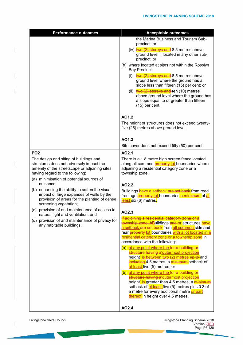
LIVINGSTONE PLANNING SCHEME 2018
Livingstone Shire Council Livingstone Planning Scheme 2018 Version 2TBD Page P6-120
Performance outcomes Acceptable outcomes
the Marina Business and Tourism Sub-precinct; or
(iv) two (2) storeys and 8.5 metres above ground level if located in any other sub-precinct; or
(b) where located at sites not within the Rosslyn Bay Precinct:
(i) two (2) storeys and 8.5 metres above ground level where the ground has a slope less than fifteen (15) per cent; or
(ii) two (2) storeys and ten (10) metres above ground level where the ground has a slope equal to or greater than fifteen (15) per cent.
AO1.2
The height of structures does not exceed twenty-five (25) metres above ground level.
AO1.3
Site cover does not exceed fifty (50) per cent.
PO2
The design and siting of buildings and structures does not adversely impact the amenity of the streetscape or adjoining sites having regard to the following:
(a) minimisation of potential sources of nuisance;
(b) enhancing the ability to soften the visual impact of large expanses of walls by the provision of areas for the planting of dense screening vegetation;
(c) provision of and maintenance of access to natural light and ventilation; and
(d) provision of and maintenance of privacy for any habitable buildings.
AO2.1
There is a 1.8 metre high screen fence located along all common property lot boundaries where adjoining a residential category zone or a township zone.
AO2.2
Buildings have a setback are set back from road frontage property lot boundaries a minimum of at least six (6) metres.
AO2.3
If adjoining a residential category zone or a township zone, bBuildings and or structures have a setback are set back from all common side and rear property lot boundaries with a lot located in a residential category zone or a township zone in accordance with the following:
(a) at any point where the for a building or structure having a‘outermost projection height’ is between two (2) metres up to and including 4.5 metres, a minimum setback of at least five (5) metres; or
(b) at any point where the for a building or structure having a‘outermost projection height’ is greater than 4.5 metres, a minimum setback of at least five (5) metres plus 0.3 of a metre for every additional metre or part thereof in height over 4.5 metres.
AO2.4

LIVINGSTONE PLANNING SCHEME 2018
Livingstone Shire Council Livingstone Planning Scheme 2018 Version 2TBD Page P6-121
Performance outcomes Acceptable outcomes
If not adjoining a residential category zone or a township zone, buildings and or structures have a setback are set back from side and rear property lot boundaries in accordance with the following:
(a) at any point where the for a building or structure having a‘outermost projection height’ is between two (2) metres up to and including 4.5 metres, a minimum setback of at least 1.5 metres; or
(b) at any point where the for a building or structure having a‘outermost projection height’ is greater than 4.5 metres, a minimum setback of at least 1.5 metres plus 0.3 of a metre for every additional metre or part thereof in height over 4.5 metres.
AO2.5
If the distance separating a window of a habitable room or a balcony or a patio is less than three (3) metres at ground level or nine (9) metres at levels above the ground level storey, of a window of a habitable room or a balcony or a patio of an adjacent building, privacy is protected by utilising the following:
(a) window sill heights a minimum of 1.5 metres above floor level; or
(b) fixed opaque glazing in any part of the window below 1.5 metres above floor level; or
(c) fixed external screens; or
(d) in the case of screening for a ground floor level, fencing to a height of 1.5 metres above ground floor level.
Vehicle Parking Space
Where located in the Rosslyn Bay Precinct – Marina Parking and Recreation Sub-precinct, Marina Wet Marine Sub-precinct, Marina Business and Tourism Sub-precinct
PO3
The development:
(a) does not reduce the existing vehicle parking supply needed for the development of preferred uses within the Marina Wet Marine Sub-precinct or the Marina Business and Tourism Sub-precinct; or
(b) is provided with sufficient parking for the expected number and type of vehicles generated by the use.
AO3.1
Despite any acceptable outcomes contained within the Development Works Code relating to vehicle parking rates, if the development is a preferred use identified in the overall outcomes of this code and it complies with the built form acceptable outcomes of this code, the minimum number of vehicle parking spaces that are to be provided within the marina parking and recreation sub-precinct is as follows:
(a) where adjoining the Marina Business and Tourism Sub-precinct: two-hundred and fifty (250) spaces; and
(b) where adjoining the Marina Dry Marine Sub-precinct: fifteen (15) spaces.
Note: The number of spaces required by this acceptable outcome overrides any total number of spaces required under the Development Works Code; however, this only applies to

LIVINGSTONE PLANNING SCHEME 2018
Livingstone Shire Council Livingstone Planning Scheme 2018 Version 2TBD Page P6-122
Performance outcomes Acceptable outcomes the circumstance where the development is a preferred use for the sub-precinct as identified in the overall outcomes.
AO3.2
If the development is a preferred use identified in the overall outcomes of this code, but it does not comply with the built form acceptable outcomes of this code, then the number of vehicle parking spaces that are to be provided within the marina parking and recreation sub-precinct is in accordance with the standards relevant to the use in compliance with Table 9.3.2.4.3 of the Development Works Code.
AO3.3
If the development is not a preferred use identified in the overall outcomes of this code, the number of vehicle parking spaces that are to be provided within the marina parking and recreation sub-precinct is in accordance with the standards relevant to the use in compliance with Table 9.3.2.4.3 of the Development Works Code.
Table 6.5.6.4.2 – Additional outcomes for assessable development
Performance outcomes Acceptable outcomes
Land use
Where not located in the Rosslyn Bay Precinct
PO4
The use is:
(a) a use within the special activities group which serves the needs of the community; or
(b) a use that is not from within the special activities group however the use:
(i) is compatible with and supports a use within the special activities group; or
(ii) does not limit or compromise the development of a use within the special activities group.
No acceptable outcome is nominated.
PO5
The use appropriately integrates with any established uses in the immediate area.
No acceptable outcome is nominated.
PO6
The use is located, designed and operated in a manner that maintains public health and safety.
No acceptable outcome is nominated.
PO7
The development of a use from within the special activities group, which is likely to have high impact on land use in the immediate area, occurs only if the location has suitable characteristics and there is appropriate design,
No acceptable outcome is nominated.

LIVINGSTONE PLANNING SCHEME 2018
Livingstone Shire Council Livingstone Planning Scheme 2018 Version 2TBD Page P6-123
siting and operational measures to minimise adverse impacts on other land use.
PO8
The development of a public use that generates frequent and a large amount of public visitation:
(a) is highly accessible; and
(b) is well located in relation to public and active transport networks.
No acceptable outcome is nominated.
Where located in the Rosslyn Bay Precinct
PO9
The use contributes to the development of a precinct which is comprised of appropriately located preferred uses for the precinct (as identified in the overall outcomes for the precinct).
No acceptable outcome is nominated.
PO10
The use appropriately integrates with any established uses in the immediate area.
No acceptable outcome is nominated.
PO11
The use is located, designed and operated in a manner that maintains public safety.
No acceptable outcome is nominated.
PO12
The use is designed in a manner which does not preclude beach or marine access by the public or otherwise adversely obstruct accessibility to public areas.
No acceptable outcome is nominated.
PO13
The use is located, designed, and operated in a manner which avoids causing significant adverse impacts on the natural environment.
No acceptable outcome is nominated.
Appearance
PO14
The development is designed in a manner that does not significantly adversely affect visual amenity when viewed from the street, public places, and the surrounding area.
No acceptable outcome is nominated.
Infrastructure
PO15
Safe, accessible, robust and reliable infrastructure relating to access and parking, energy supply, roads, roof and allotment drainage, sewage and wastewater treatment and disposal, stormwater management, telecommunications, and water supply, is adequately provided for the development in accordance with best practice and endorsed standards for the location, and relative to the needs of the development.
AO15.1
The development complies with the requirements of the Development Works Code.

LIVINGSTONE PLANNING SCHEME 2018
Livingstone Shire Council Livingstone Planning Scheme 2018 Version 2TBD Page P6-124

LIVINGSTONE PLANNING SCHEME 2018
Livingstone Shire Council Livingstone Planning Scheme 2018 Version 2TBD Page P6-125
6.5.7. Specialised centre zone code
6.5.7.1. Application
This code applies to the assessment of development if it is identified as an applicable code for development, as specified in the assessment benchmarks column in the tables of assessment located in Part 5 of the planning scheme.
When using this code, reference should be made to section 5.3.2 and where applicable, section 5.3.3 located in Part 5 of the planning scheme.
All subject matter in this code is applicable to the development assessment, unless the following circumstance arises:
(1) The heading of a specific benchmarks for assessment table specifies otherwise; or
(2) A heading within a specific benchmarks for assessment table specifies that the outcomes apply to a specific type of development or to development at a specific location; or
(3) A performance outcome or acceptable outcome specifies that the outcomes apply to a specific type of development or to development at a specific location.
In the circumstance where point (2) or point (3) above arises the following applies:
(1) the development assessment outcomes apply only to the type of development specified or only to development at the location specified; and
(2) the development must still be assessed against all other general subject matter of the code (for example, assessment benchmarks including but not limited to those relating to built form, appearance, or general land use).
6.5.7.2. Purpose
The purpose of the specialised centre zone code is:
(1) to identify the desired character and amenity for the zone and to protect it from incompatible development;
(2) to provide for the development of specialised centres comprising a mixture of different uses from within the business activities group;
(3) to provide for the development of a limited range and mix of uses from within other activities groups only if they are compatible with and do not compromise the development of preferred land uses and they do not undermine the role and function of other centres, centre category zoned areas or industry category zoned areas;
(4) to enable specialised centres to strengthen and maintain their special role and function in the network of centres for the planning scheme area; and
(5) to facilitate the achievement of the overall outcomes sought for the zone.
6.5.7.3. Overall outcomes
The purpose of the code will be achieved through the following overall outcomes:
(1) the development is:
(a) a use from within the business activities group; or
(b) a use that is compatible with uses from within the business activities group, which due to its characteristics and special requirements (such as those relating to transport, lot size, and built form) is not preferred or cannot be easily provided for in other zones;
(2) the development of a use within the business activities group is a preferred use within the zone in the following circumstances:
(a) it is an agricultural supplies store; or
(b) it is a car wash; or
(c) it is a funeral parlour; or

LIVINGSTONE PLANNING SCHEME 2018
Livingstone Shire Council Livingstone Planning Scheme 2018 Version 2TBD Page P6-126
(d) it is a garden centre; or
(e) it is hardware and trade supplies; or
(f) it is outdoor sales; or
(g) it is a sales office; or
(h) it is a service station; or
(i) it is a showroom; or
(j) it is veterinary services;
(3) if the development is a use from within the business activities group and it is bulk landscape supplies, the development occurs within the zone only if the site has suitable characteristics and there is appropriate design and siting to ensure that there are no adverse impacts on any sensitive land use or on other development in the immediate area;
(4) the development of a use that is not within the business activities group occurs within the zone only in the following circumstances:
(a) it is compatible with and does not compromise the development of the preferred uses identified in Overall Outcome (2);
(b) it does not undermine the viability, role or function of other centres, centre category zoned areas or industry category zoned areas;
(c) it is designed to integrate with development in the immediate area;
(d) it is consistent with the built form and appearance of development in the immediate area;
(e) it is located at a site adjoining an appropriate road in the planning scheme road hierarchy; and
(f) the use:
(i) is emergency services; or
(ii) is an environment facility; or
(iii) is a food and drink outlet which primarily services the following:
(A) workers or customers of other business in the zone; or
(B) the convenience needs of travellers along major transport routes; or
(iv) is indoor sport and recreation; or
(v) is a low impact industry; or
(vi) is a park; or
(vii) is a landing; or
(viii) is a service industry; or
(ix) is from within the special activities group and it is an essential component of infrastructure servicing the community;
(5) the development is compatible with an urban form that is characterised by:
(a) low to moderate building heights;
(b) moderate site cover; and
(c) use of vegetation screening and buffering between development and any adjoining sensitive land use;
(6) the appearance of development results in a high level of visual amenity when viewed from the street, public places, and the surrounding area; and
(7) the development is provided with adequate infrastructure and essential services.
6.5.7.4. Specific benchmarks for assessment

LIVINGSTONE PLANNING SCHEME 2018
Livingstone Shire Council Livingstone Planning Scheme 2018 Version 2TBD Page P6-127
Table 6.5.7.4.1 – Outcomes for development that is accepted subject to requirements and assessable development
Performance outcomes Acceptable outcomes
Built Form
PO1
The height and bulk of buildings and structures are consistent with the intended character of the zone and do not adversely impact the character or amenity of the streetscape, adjoining sites and surrounding area.
AO1.1
The height of buildingsBuilding height does not exceed twelve (12) metres above ground level.
AO1.2
Site cover does not exceed fifty (50) per cent.
PO2
The design and siting of buildings and structures does not adversely impact the amenity of the streetscape or adjoining sites having regard to the following:
(a) minimisation of potential sources of nuisance;
(b) enhancing the ability to soften the visual impact of large expanses of building walls by the provision of areas for the planting of dense screening vegetation;
(c) provision of and maintenance of access to natural light and ventilation; and
(d) provision of and maintenance of privacy for any habitable buildings.
AO2.1
There is a 1.8 metre high screen fence located along all common property lot boundaries where adjoining a residential category zone or a township zone.
AO2.2
Buildings are set backhave a setback from the primary road frontage lot boundaries boundary a minimum in accordance with the following:
(a) a setback from the primary road frontage lot boundary of at least six (6) metres; and
(a)(b) a setback from a secondary road frontage lot boundary of at least three (3) metres.
AO2.3
If adjoining a residential category zone or a township zone, bBuildings and or structures have a setbackare set back from all common side and rear property lot boundaries with a lot located in a residential category zone or a township zone in accordance with the following:
(a) at any point where the for a building or structure having a‘outermost projection height’ is between two (2) metres up to and including 4.5 metres, a minimum setback of at least five (5) metres; or
(b) at any point where the for a building or structure having a‘outermost projection height’ is greater than 4.5 metres, a minimum setback of at least five (5) metres plus 0.3 of a metre for every additional metre or part thereof in height over 4.5 metres.
AO2.4
If adjoining a residential category zone or a township zone, any windows that have direct views into adjoining residential buildings are provided with fixed screening that is a maximum of seventy-five (75) per cent transparent to obscure views into the adjoining residential

LIVINGSTONE PLANNING SCHEME 2018
Livingstone Shire Council Livingstone Planning Scheme 2018 Version 2TBD Page P6-128
Performance outcomes Acceptable outcomes
building and to maintain privacy for those residents.
Appearance
PO3
The development is designed in a manner that contributes to a high level of visual amenity when viewed from the street, public places, and the surrounding area by incorporating elements including but not limited to the following:
(a) emphasis on entry points;
(b) orientation to the street and any public places;
(c) inclusion of buildings, structures or vegetation to screen any material stockpiles, waste storage areas, and building plant from view of the street or other public places;
(d) inclusion of vegetation to soften the visual impact of any large unarticulated building walls when viewed from residential category zones and scenic transport routes; and
(e) inclusion of vegetation between buildings and property lot boundaries that adjoin major transport routes; and
(f) external building walls having variations in textures, materials and colours.
AO3.1
The development has a pedestrian entry point at or visible from the primary road frontage.
AO3.2
Any material stockpiles or waste storage areas are screened from view of the street and adjoining public places by one or more of the following:
(a) a solid screen fence; or
(b) a wall; or
(c) dense vegetation.
AO3.3
Any building plant:
(a) is screened from view of the street by one or more of the following:
(i) a solid screen fence, or
(ii) a roof design feature; or
(iii) a wall; or
(iv) dense vegetation; or
(b) is located within, underneath or central to the building so as to not be visible from the street.
AO3.4
There is a densely vegetated buffer area having a depth of at least five (5) metres from the property lot boundary, located along all common property lot boundaries where adjoining any residential category zone or a township zone.
AO3.5
There is a densely vegetated area having a depth of at least five (5) metres from the property lot boundary, located along all property lot boundaries which adjoin an identified scenic transport route on an overlay map.
AO3.6
The densely vegetated areas specified in AO3.4 and AO3.5 comply with the following:
(a) there is a minimum of two (2) rounded canopy trees for every five (5) linear metres or part thereof of the length of the road frontage property lot boundary; and

LIVINGSTONE PLANNING SCHEME 2018
Livingstone Shire Council Livingstone Planning Scheme 2018 Version 2TBD Page P6-129
Performance outcomes Acceptable outcomes
(b) there is a minimum of two (2) shrubs for every three (3) linear metres or part thereof of the length of the road frontage property lot boundary; and
(c) any established native tree species having a height exceeding two (2) metres, or a trunk diameter of thirty (30) centimetres are retained within vegetation area.
AO3.7
There is a vegetated area having a depth of at least two (2) metres from the property lot boundary, located along all road frontage lot boundaries (other than a boundary adjoining an identified scenic transport route on an overlay map), excluding the access driveway.
AO3.8
External building walls have at least three (3) variations, with the variations consisting of one or more of the following:
(a) changes in surface textures; or
(b) changes in materials; or
(c) changes in colours.
Table 6.5.7.4.2 - Additional outcomes for assessable development
Performance outcomes Acceptable outcomes
Land use
PO4
The use:
(a) is a preferred use for the zone (as identified in the overall outcomes for the zone); or
(b) is identified in the overall outcomes for the zone and is compatible with and does not limit or compromise the development of a preferred use for the zone.
No acceptable outcome is nominated.
PO5
Development does not undermine the viability, role or function of other centres, centre category zoned areas or industry category zoned areas.
No acceptable outcome is nominated.
PO6
The use appropriately integrates with any established uses in the immediate area.
No acceptable outcome is nominated.
PO7
The use is located, designed and operated in a manner that maintains public safety.
No acceptable outcome is nominated.
PO8 No acceptable outcome is nominated.

LIVINGSTONE PLANNING SCHEME 2018
Livingstone Shire Council Livingstone Planning Scheme 2018 Version 2TBD Page P6-130
Performance outcomes Acceptable outcomes
The development of a use from within the special activities group, which is likely to have high impact on land use in the immediate area, occurs only if the location has suitable characteristics and there is appropriate design, siting and operational measures to minimise adverse impacts on other land use.
Appearance
PO9
Large expanses of blank unarticulated building walls are broken up by use of fenestration, recesses, wall offsets, balconies, projections, or other building design features so that the development has an appearance which provides visual interest and contributes to a high level of visual amenity when viewed from the street, public places, and the surrounding area.
No acceptable outcome is nominated.
Infrastructure
PO10
Safe, accessible, robust and reliable infrastructure relating to access and parking, energy supply, roads, roof and allotment drainage, sewage and wastewater treatment and disposal, stormwater management, telecommunications, and water supply, is adequately provided for the development in accordance with best practice and endorsed standards for the location, and relative to the needs of the development.
AO10.1
The development complies with the requirements of the Development Works Code.

LIVINGSTONE PLANNING SCHEME 2018
Livingstone Shire Council Livingstone Planning Scheme 2018 Version 2TBD Page P6-131
6.5.8. Township zone code
6.5.8.1. Application
This code applies to the assessment of development if it is identified as an applicable code for development, as specified in the assessment benchmarks column in the tables of assessment located in Part 5 of the planning scheme.
When using this code, reference should be made to section 5.3.2 and where applicable, section 5.3.3 located in Part 5 of the planning scheme.
All subject matter in this code is applicable to the development assessment, unless the following circumstance arises:
(1) The heading of a specific benchmarks for assessment table specifies otherwise; or
(2) A heading within a specific benchmarks for assessment table specifies that the outcomes apply to a specific type of development or to development at a specific location; or
(3) A performance outcome or acceptable outcome specifies that the outcomes apply to a specific type of development or to development at a specific location.
In the circumstance where point (2) or point (3) above arises the following applies:
(1) the development assessment outcomes apply only to the type of development specified or only to development at the location specified; and
(2) the development must still be assessed against all other general subject matter of the code (for example, assessment benchmarks including but not limited to those relating to built form, appearance, or general land use).
6.5.8.2. Purpose
The purpose of the township zone code is:
(1) to identify the desired character and amenity for the zone and to protect it from incompatible development;
(2) to provide for the development of small coastal and rural settlements comprising accommodation activities in the form of detached dwellings (predominantly detached dwelling houses) as dominant land use within the zone;
(3) to provide for the development of a limited range of other uses within the accommodation activities group if they contribute the diversity of housing options needed for the township or it caters for the short-term stay of visitors;
(4) to retain the role of townships as important support centres for coastal and rural communities by providing for the development of a limited range of non-residential uses which are compatible with and support the township and service convenience needs of the residents of the township and of the surrounding rural area; and
(5) to facilitate the achievement of the overall outcomes sought for the zone.
6.5.8.3. Overall outcomes
The purpose of the code will be achieved through the following overall outcomes:
(1) the development is:
(a) a use within the accommodation activities group which:
(i) provides only for the long-term stay of residents or short-term stay of visitors;
(ii) is designed to be consistent with the character of a township which is predominantly comprised of detached dwellings; or
(b) a use which supports the residential dwellings of the township; or
(c) a use which services the convenience (day to day) needs of residents of the township or surrounding rural area; and

LIVINGSTONE PLANNING SCHEME 2018
Livingstone Shire Council Livingstone Planning Scheme 2018 Version 2TBD Page P6-132
(2) the development of a use within the accommodation activities group is a preferred use within the zone in the following circumstances:
(a) it is a caretaker’s accommodation; or
(b) it is a community residence; or
(c) it is a dwelling house; or
(d) it is a dwelling unit; or
(e) it is a home based business and it complies strictly with specified design, siting, and operational requirements; and
(3) the development of a use within the recreation activities group is a preferred use within the zone in the following circumstances:
(a) it is an environment facility; or
(b) it is a park;
(4) if the development is a use within the accommodation activities group and it is not identified in Overall Outcome (2) above, the development occurs within the zone only in the following circumstances:
(a) it is designed to integrate with development in the immediate area;
(b) it is designed to be consistent with the character of the township and other uses in the immediate area;
(c) it is located at a site adjoining an appropriate road in the planning scheme road hierarchy; and
(e) the use: (i) is non-resident workforce accommodation; or
(ii) is a relocatable home park; or
(iii) is a residential care facility; or
(iv) is a retirement facility; or
(v) is rooming accommodation; or
(vi) is short-term accommodation; or
(vii) is a tourist park; and
(5) the development of a use that is not within the accommodation activities group occurs within the zone only in the following circumstances:
(a) it is designed to integrate with development in the immediate area;
(b) it is small in scale and provide convenience goods and services to support the residents of the townships and surrounding rural communities;
(c) it is consistent with the built form and appearance of development in the immediate area;
(d) it is located at a site adjoining an appropriate road in the planning scheme road hierarchy; and
(e) the use:
(i) is within the business activities group and is:
(A) an agricultural supplies store; or
(B) a funeral parlour; or
(C) a car wash; or
(D) a garden centre; or
(E) a hardware and trade supplies; or

LIVINGSTONE PLANNING SCHEME 2018
Livingstone Shire Council Livingstone Planning Scheme 2018 Version 2TBD Page P6-133
(F) a market; or
(G) outdoor sales; or
(H) a sales office; or
(I) a service station; or
(J) a veterinary service; or
(ii) is within the centre activities group and is:
(A) an adult store; or
(B) a food and drink outlet; or
(C) health care services; or
(D) a shop; or
(E) a shopping centre that has a size determined based on the demonstrated local needs of the township and surrounding rural area; or
(iii) is within the community activities group and is:
(A) a child care centre; or
(B) a club; or
(C) a community care centre; or
(D) a community use; or
(E) an education establishment; or
(F) a hospital; or
(G) a place of worship; or
(iv) is within the entertainment activities group and is:
(A) a bar; or
(B) a function facility; or
(C) a hotel; or
(D) a theatre; or
(v) is within the industrial activities group and is:
(A) a low impact industry; or
(B) a service industry; or
(vi) is within the recreation activities group and is:
(A) indoor sport and recreation; or
(B) outdoor sport and recreation; or
(vii) is within the special activities group and is:
(E) a cemetery; or
(F) emergency services; or
(G) a landing; or
(H) other uses within the special activities group if they are an essential component of infrastructure servicing the township; and
(6) development that is likely to have a high impact on sensitive land use does not occur within the zone;
(7) development contributes to a high level of amenity and an attractive living environment;

LIVINGSTONE PLANNING SCHEME 2018
Livingstone Shire Council Livingstone Planning Scheme 2018 Version 2TBD Page P6-134
(8) sensitive land use is not located in proximity to any established incompatible uses without appropriate design and siting to minimise adverse impacts on amenity;
(9) the development is compatible with a form that is characterised by:
(a) a low ‘net’ dwelling density;
(b) building heights not exceeding two (2) storeys above ground level;
(c) low site cover;
(d) provision of private or communal open space for dwellings;
(e) appealing streetscapes and public places; and
(10) the appearance of development provides visual interest and contributes to a high level of visual amenity when viewed from the street, public places, and the surrounding area; and
(11) the development is provided with adequate infrastructure and essential services.
6.5.8.4. Specific benchmarks for assessment
Table 6.5.8.4.1 – Outcomes for development that is accepted subject to requirements and assessable development
Performance outcomes Acceptable outcomes
Built form
PO1
The height and bulk of buildings and structures are consistent with the intended character of the zone and do not adversely impact the character or amenity of the streetscape, adjoining sites and surrounding area.
AO1.1
The height of buildingsBuilding height (for buildings other than a Class 10a building under the Building Code of Australia) does not exceed:
(a) two (2) storeys and 8.5 metres above ground level where the ground has a slope less than fifteen (15) per cent; or
(b) two (2) storeys and ten (10) metres above ground level where the ground has a slope equal to or greater than fifteen (15) per cent.
AO1.2
The heightBuilding height of a standalone Class 10a building under the Building Code of Australia, being a garage or shed, does not exceed the lesser of the following:
(a) if there is a dwelling house on the site, the height of the dwelling house; or
(b) five (5) metres to the apex of the Class 10a building.
AO1.3
The volume of a standalone Class 10a building under the Building Code of Australia, being a garage or shed, does not exceed three (3) per cent of the lot volume. Editor’s note: Lot volume is defined in SC1.2 Administrative definitions.
AO1.43
Site cover does not exceed fifty (50) per cent.

LIVINGSTONE PLANNING SCHEME 2018
Livingstone Shire Council Livingstone Planning Scheme 2018 Version 2TBD Page P6-135
Performance outcomes Acceptable outcomes
PO2
The design and siting of buildings and structures results in a high level of on-site amenity, and does not adversely impact the character or amenity of the streetscape or adjoining sites having regard to the following:
(a) minimisation of potential sources of nuisance;
(b) provision of and maintenance of access to natural light and ventilation;
(c) provision of and maintenance of open space for any dwellings; and
(d) provision of and maintenance of the privacy for any habitable buildings.
AO2.1
There is a 1.8 metre high screen fence located along all common property lot boundaries between any sensitive land use and any use within the business activities group, centre activities group, entertainment activities group, industrial activities group or special activities group.
AO2.2
Buildings or structures have a setbackare set back from side, rear, and road frontage property lot boundaries in compliance with the setback standards identified in Table SC10.1.2 of Schedule 10.in accordance with the following:
garages are set back a minimum of six (6) metres from the primary road frontage property boundary;
a standalone class 10a building under the Building Code of Australia being a garage or shed, is set back a minimum of six (6) metres from the primary road frontage boundary; and
a dwelling has a minimum set back of six (6) metres from the primary road frontage boundary.
AO2.3
Buildings are set back from side and rear property boundaries in accordance with the following:
(a) for a building or structure having a height up to and including 4.5 metres, a minimum setback of 1.5 metres; or
(b) for a building or structure having a height greater than 4.5 metres, a minimum setback of 1.5 metres plus 0.3 of a metre for every additional metre in height over 4.5 metres.
AO2.43
The development of a use within the accommodation activities group (other than an ancillary secondary dwelling) provides an open space area in accordance with the following:
(a) each dwelling is provided with a private open space area as follows:
(i) a minimum area directly accessible from the dwelling of fifty (50) square metres (inclusive of verandas, patios and terraces) and part of the area has minimum dimensions of six (6) metres by six (6) metres; or
(ii) if a dwelling is located entirely or predominantly above the ground level storey, each dwelling has a balcony, or a veranda, or a deck, or a roof top area

LIVINGSTONE PLANNING SCHEME 2018
Livingstone Shire Council Livingstone Planning Scheme 2018 Version 2TBD Page P6-136
Performance outcomes Acceptable outcomes
directly accessible from the main living area, having a minimum private area of ten (10) square metres and the area has minimum dimensions of three (3) metres by three (3) metres; or
(b) the development has a communal open space area of twenty (20) per cent of the total site area and part of the area has minimum dimensions of six (6) metres by six (6) metres.
AO2.54
If the distance separating a window of a habitable room or a balcony or a patio is less than three (3) metres at ground level or nine (9) metres at levels above the ground level storey, of a window of a habitable room or a balcony or a patio of an adjacent building, privacy is protected by utilising the following:
(a) window sill heights a minimum of 1.5 metres above floor level; or
(b) fixed opaque glazing in any part of the window below 1.5 metres above floor level; or
(c) fixed external screens; or
(d) in the case of screening for a ground floor level, fencing to a height of 1.5 metres above ground floor level.
Appearance
PO3
The development is designed in a manner that contributes to a high level of visual amenity when viewed from the street, public places, and the surrounding area, by incorporating elements including but not limited to the following:
(a) emphasis on entry points;
(b) orientation to the street and any public places;
(c) inclusion of structures or vegetation to screen any material stockpiles, waste storage areas, and building plant from view of the street or other public places; and
(d) inclusion of vegetation to screen any large unarticulated walls.
AO3.1
T
The development has a pedestrian entry point which is visible and accessible from the primary road frontage.
AO3.2
If fencing is provided between the road frontage property lot boundary and the front building line, the fencing is:
(a) a maximum height of 1.2 metres; or
(b) a maximum height of 1.8 metres if having a minimum transparency of fifty (50) per cent.
AO3.3
A standalone class 10a building under the Building Code of Australia, being a garage or shed, has a maximum visible width of seven (7) metres when viewed from a position at the primary road frontage property boundary located

LIVINGSTONE PLANNING SCHEME 2018
Livingstone Shire Council Livingstone Planning Scheme 2018 Version 2TBD Page P6-137
Performance outcomes Acceptable outcomes
perpendicular to and directly in front of the Class 10a building.
AO3.43
Any material stockpiles, waste storage areas, or building plant is screened from view of the street and adjoining public places by one or more of the following:
(a) a solid screen fence, or
(b) a roof design feature; or
(c) a wall; or
(d) dense vegetation.
AO3.54
There is a densely vegetated buffer area having a depth of at least five (5) metres from the property lot boundary, located along all common property lot boundaries between a sensitive land use and any adjacent use within the business activities group, centre activities group, entertainment activities group, industrial activities group or special activities group.
Table 6.5.8.4.2 – Additional outcomes for assessable development
Performance outcomes Acceptable outcomes
Land use
PO4
The use contributes to the development of a township which:
(a) comprise the following:
(i) preferred uses for the zone (as identified in the overall outcomes for the zone); or
(ii) other accommodation activities (as identified in the overall outcomes for the zone) that are designed to be consistent in form and appearance with preferred uses for the zone; or
(b) comprise other small-scale relatively low-impact uses (as identified in the overall outcomes for the zone) that are not within the accommodation activities group, where they service the community or convenience needs of the residents of the township or the surrounding rural area.
No acceptable outcome is nominated.
PO5
The use contributes to a high level of amenity and an attractive living environment for residents in the immediate area.
No acceptable outcome is nominated.

LIVINGSTONE PLANNING SCHEME 2018
Livingstone Shire Council Livingstone Planning Scheme 2018 Version 2TBD Page P6-138
Performance outcomes Acceptable outcomes
PO6
The use appropriately integrates with any established dwellings and other sensitive land use in the immediate area.
No acceptable outcome is nominated.
PO7
The development of a use that is not within the accommodation activities group occurs only if it is located at a site adjoining a road that is identifiable as the main street of the township or that is classified as a collector road or a higher order road in the road hierarchy, and the road:
(a) is designed to accommodate the traffic generated by the use;
(b) provides for convenient and safe access; and
(c) can minimise nuisance and disturbance to the surrounding residential area.
AO7.1
If the development is a use that is not within the accommodation activities group it is located adjoining a road in accordance with the following:
(a) if in the township of Cawarral, adjoining the following roads:
(i) Annie Drive; or
(ii) Cawarral Road; or
(b) if in the township of Keppel Sands, adjoining the following roads:
(i) Roden Street; or
(c) if in the township of Marlborough, adjoining the following roads:
(i) Railway Street; or
(d) if in the township of Mount Chalmers, adjoining the following roads:
(i) Mount Chalmers Road; or
(e) if in the township of Ogmore, adjoining the following roads:
(i) Dempsey Street; or
(f) if in the township of Stanage, adjoining the following roads:
(i) Banksia Road; or
(g) if in the township of The Caves, adjoining the following roads:
(i) Rossmoya Road; or
(ii) Buch Square; or
(h) if in the township of Yaamba, adjoining the following roads:
(i) Yaamba Road.
Dwelling density
PO8
If the development is for a use within the accommodation activities group, the use is designed in a manner that is compatible with the following:
(a) the planned low dwelling density for the zone;
(b) the ability of the land and infrastructure to support the development.
No acceptable outcome is nominated.
Appearance

LIVINGSTONE PLANNING SCHEME 2018
Livingstone Shire Council Livingstone Planning Scheme 2018 Version 2TBD Page P6-139
Performance outcomes Acceptable outcomes
PO9
Large expanses of blank unarticulated building walls are broken up by use of fenestration, recesses, wall offsets, balconies, projections, or other building design features so that the development has an appearance which provides visual interest and contributes to a high level of visual amenity when viewed from the street, public places, and the surrounding area.
No acceptable outcome is nominated.
Infrastructure
PO10
Safe, accessible, robust and reliable infrastructure relating to access and parking, energy supply, roads, roof and allotment drainage, sewage and wastewater treatment and disposal, stormwater management, telecommunications, and water supply, is adequately provided for the development in accordance with best practice and endorsed standards for the location, and relative to the needs of the development.
AO10.1
The development complies with the requirements of the Development Works Code.