02 Contents Frame - Food and Agriculture Organization of the
124
6 ISSN 1729-0554 LAND AND WATER DISCUSSION PAPER Land evaluation Towards a revised framework
Transcript of 02 Contents Frame - Food and Agriculture Organization of the
6
ISSN 1729-0554
LAND ANDWATER
DISCUSSIONPAPER
TC/D/A1080E/1/04.07
Land evaluation Towards a revised framework Land evaluation Towards a revised framework
LAND AND WATER DISCUSSION PAPER
6
This report reviews the concern raised that land should not only be
evaluated for the goods it provides, but also for the services it
renders. Before updating the Framework for Land Evaluation this
publication serves as a discussion paper that draws attention to the
various facets related to climate change, biodiversity and
desertification in addition to new tools and approaches that are
presently available to undertake land evaluation.
Land evaluationTowards a revised framework

Land evaluation LAND AND WATER
DISCUSSION PAPER
6
FOOD AND AGRICULTURE ORGANIZATION OF THE UNITED NATIONSRome, 2007
Towards a revised framework

The views expressed in this publication are those of the authors and do not necessarily reflect the views of the Food and Agriculture Organization of the United Nations.
The designations employed and the presentation of material in this informationproduct do not imply the expression of any opinion whatsoever on the part of the Food and Agriculture Organization of the United Nations concerning the legal or development status of any country, territory, city or area or of its authorities, or concerning the delimitation of its frontiers or boundaries.
All rights reserved. Reproduction and dissemination of material in this information product for educational or other non-commercial purposes are authorized without any prior written permission from the copyright holders provided the source is fullyacknowledged. Reproduction of material in this information product for resale or other commercial purposes is prohibited without written permission of the copyright holders. Applications for such permission should be addressed to: Chief Electronic Publishing Policy and Support BranchCommunication Division FAO Viale delle Terme di Caracalla, 00153 Rome, Italy or by e-mail to: [email protected]
© FAO 2007

iii
Contents
Preface vi
Acknowledgements vii
Acronyms and abbreviations ix
Executive summary xiii
1. The need for revision 1Origins and applications of the framework for land evaluation 1
The objectives of land evaluation 1
An expanded definition of land and land resources 2Trends calling for revision of the framework 2Objectives and scope of this document 4Outline of this document 4
2. Historical development 5Land evaluation and classification before the framework 5
Origin and nature of the framework 6Origin 6Six principles 6Concepts and procedures 7
Land evaluation systems originating since the framework 8Soil survey and crop yield interpretations 8Agro-ecological zoning 9Combination of land evaluation and farming systems analysis 9Computerized land evaluation systems and geographic information systems 10Land evaluation using earth observation 12
The challenge for the future 12
3. Expansion of concepts and definitions 13Functions of the land and limiting factors 13
Functions of the land 13Limiting factors (limitations) 15
Concepts and definitions 18
Environmental concerns 18Agro-ecosystems analysis and landscape value 18Sustainable livelihood 23Stakeholder participation 24Cross-sectoral approach 25Qualitative or quantitative and physical or economic evaluation 26Decision-making levels and scales 26
Links with basic concepts of land evaluation 27
4. Revised principles and procedures 29Extended and additional principles 29

iv
Land suitability in terms of use and services of the land 30Comparison of benefits obtained and inputs needed 30Multi-disciplinarity and cross-sectoral analysis 31Context and environmental concerns 31Sustainability includes productivity, social equity and environmental aspects 31Comparison of different land uses and services 31Land evaluation should consider all stakeholders 32Scale and level of decision-making 32
Outline of procedures 32 i. Initial consultation with all stakeholders 34ii. Diagnosis of land use problems 34iii. The identification of kinds of land use (land utilization types) 34iv. Land use requirements, functions and limitations 35v-vi. Description of land mapping units and land qualities 35vii. Economic and social analysis 36viii. Comparison of land use with land 37ix-x. Agronomic and biophysical research programme 37xi. Land suitability classification 38xii. Presentation of results 38
5. Outline of a revised framework for land evaluation 39Preface 39Chapter 1 – The need for revision 39Chapter 2 – Historical development of land evaluation 39Chapter 3 – Expansion of concepts and definitions 39Chapter 4 – Land suitability classifications 39Chapter 5 – Land evaluation procedures 39References 40Annexes 40
References 41
Annexes 611. Glossary 61
2. Data for land evaluation 69
3. Tools for land evaluation 75
4. Case studies 101

v
List of figures
1. Schematic representation of activities in a newly proposed outline of land evaluation procedures 33

vi
Acknowledgements
This report is the result of a long effort of the FAO Land and Water Division, initiated by Wim Sombroek and Parviz Koohafkan, to update the Framework for Land Evaluation. Several drafts of the report were prepared by Ms Anne Gobin and Ms Nathalie Cools, and reviewed by Anthony Young, Jules Pretty, Robert Brinkman, Rudi Dudal and Philippe Mahler, the latter providing the final text. Compiling this report was under the guidance of F. Nachtergaele of the FAO Land Tenure and Management Unit (NRLA).
The editing report benefited from Ms. L. Chalk who assisted in its final preparation.

vii
Preface
The 70s saw the emergence of worldwide concerns for the capacity of the planet to feed its growing population while ensuring the conservation of its natural resources and the protection of the environment. As a global inventory of soil resources was being conducted under the auspices of FAO and UNESCO, an internationally accepted methodology was elaborated concurrently to assess the potentialities as well as the limits of the world’s land resources for development. The Land Evaluation Framework, which was issued by FAO in 1976, was not confined to the evaluation of land potentials for agriculture: alternative land uses such as forestry and nature conservation were also considered and the protection of the environment was included among the criteria used in the determination of the land suitability for a given use.
The need for a revision of the Land Evaluation Framework was not felt necessary for almost 30 years. The guidelines of the Framework were further developed in diverse publications for specific kinds of land uses such as irrigated agriculture, forestry, rain fed farming and applied in many countries without calling for significant changes in the overall methodology.
What changed during the last decades, however, was the scope and purpose of the land evaluations. Initially land evaluations were carried out mostly for land use planning and land development projects. In general, the purpose was to introduce major land use changes, both more profitable and better adapted to the land conditions, often involving investment and technical assistance from governments and other sources. Nowadays, the focus of land evaluation is mainly placed on solving technical as well as socio-economic and environmental problems in the use of lands which have been developed, are fully utilized already and often are overexploited and degraded. Land evaluations nowadays help solving conflicting demands on limited land resources. The solutions of these problems do not necessarily call for drastic changes in the existing kind of land use but more often for adjustments in the land management conditions and management practices and for land improvement or protection works. The solution of land use conflicts also call for more participation, mediation and arbitration efforts among the diverse parties concerned with land use.
As the purpose and scope of land evaluations shifted to a wider range of concerns, it is now felt necessary to include additional concepts, definitions, principles and procedures in the Framework so as to address them more systematically. In particular, the new concerns about the sustainability of land use should be addressed and their implications fully examined. The requirements for the protection of the environment, the economic viability of the land use over a longer term and the social acceptability of land use conditions necessitate more complex studies of the land resources, of the land uses, of their interactions and of their environment. Above all, they call for the involvement, not only of more specialists and of all the land users, actual or potential, but also of all the other stakeholders in the land use, and this in the whole process of land evaluation.
A revision of the 1976 Land Evaluation Framework thus becomes “a tall order” requiring wide consultations and thorough discussions. The present document attempts to cover all what this revision might entail and encompass, including new advances made in several areas. At this stage, its aim is that of a discussion paper to raise awareness and interest in a number of aspects which are relevant to the subject. Wide-ranging discussions should decide what should be ultimately retained in a revised general framework and what could possibly be left to other activities, upstream or downstream

viii
of land evaluation or conducted in parallel or even elaborated in land evaluation guidelines for specific purposes.

ix
Acronyms and abbreviations
AEI Agro-environmental indicator
AEZ Agro-ecological zoning
AGL Land and Water Development Division, FAO
ALES Automated Land Evaluation System
ALU Agricultural land use
ASSOD Soil degradation in South and Southeast Asia
ASTER Advanced Space-borne Thermal Emission and Reflection Radiometer
AVHRR Advanced Very High Resolution Radiometer
AWC Available water content
BIO Soil microbial biomass
BOD/COD Biological oxygen demand/ chemical oxygen demand
BoR United States Bureau of Reclamation
C Carbon
CAPRi Collective Action and Property Rights
CBD Convention on Biological Diversity
CDE Centre for Development and Environment
CGIAR Consultative Group for International Agricultural Research
CGRFA Commission for Genetic Resources for Food and Agriculture
CGMS Crop Growth Monitoring System
COLA Centre for Ocean-Land-Atmosphere Studies
CIDT Centre for International Development and Training
CORINE CO-oRdination of INformation on the Environment
CPGR Commission for Plant Genetic Resources
CR Critical moisture content
CYSLAMB Crop Yield Simulation and Land Assessment Model for Botswana
DEM Digital elevation model
DN Digital number
DPM Decomposable plant material
DPSIR Driving Force-Pressure-State-Impact-Response
DSR Driving Force-State-Response
DTM Digital terrain model
Earth Summit See UNCED
EC European Commission
ECOSOC United Nations Economic and Social Council
EEA European Environment Agency
EIA Environmental Impact Assessment

x
EROS Earth Resources Observation Systems Data Centre
FADN Farm Accountancy Data Network
Eurostat Statistical Office of the European Communities
FC Field capacity
FCC Fertility Capability Classification
FESLM Framework for Evaluating Sustainable Land Management
FPAR Fraction of photosynthetically active radiation
FSA Farming systems analysis
FSR Farming systems research
FSS Farm structure survey
GDP Gross domestic product
GIS Geographic information system
GISCO Geographic Information System of the European Commission
GLASOD Global Assessment of Human Induced Soil Degradation
GPS Global positioning system
HUM Humified organic matter
IARC International Agricultural Research Centre
IFAD International Fund for Agricultural Development
IFPRI International Food Policy Research Institute
IIED International Institute for Environment and Development
IIRR International Institute of Rural Reconstruction
ILEIA Centre for Information on Low External Input and Sustainable
Agriculture
ILES Integrated land evaluation system
ILRA Integrated land resources analysis
ILRI International Livestock Research Institute
INRM Integrated natural resources management
IOM Inert organic matter
ISLE Intelligent System for Land Evaluation
ISRIC International Soil Reference and Information Centre
ITA Integrated toposequence analysis
ITC International Institute for Geo-information Science and Earth
Observation (former International Training Centre for Aerial Survey)ITM Integrated transect method
IUCN World Conservation Union (former International Union for the
Conservation of Nature)
LAI Leaf area index
LC Land characteristic
LCC Land capability classification
LE Land evaluation
LEFSA Land evaluation and farming systems analysis

xi
LESA Land evaluation and site assessment
LGP Length of growing period
LQ Land quality
LUCAS Land Use/Cover Area Frame Statistical Survey
LUCIE Land use capability investigation and evaluation
LUCTOR Land Use Crop Technical coefficient generatOR
LUR Land use requirement
LUT Land utilization type
MicroLEIS Mediterranean Land Evaluation Information System
MARS Monitoring Agriculture with Remote Sensing
MODIS Moderate Resolution Imaging Spectroradiometer
N Nitrogen
N1, N2 Unsuitable suitability classes in land evaluation:
N1 – currently not suitable, N2– permanently not suitable
NASA National Aeronautics and Space Administration
NCDC National Climatic Data Centre
NDVI Normalized difference vegetation index
NGO Non-governmental organization
NMS National Meteorological Services
NOAA National Oceanic and Atmospheric Administration
OECD Organisation for Economic Cooperation and Development
NUTS Nomenclature of Territorial Units for Statistics
P Phosphorus
PASTOR Pasture and Animal System Technical coefficient generatOR
PAWC Plant-available water content
PESERA Pan-European Soil Erosion Risk Assessment
PLAR Participatory learning and action research
PS Profile set
PRA Participatory rural appraisal
PWP Permanent wilting point
RD Recherche développement
RIVM Netherlands Institute for Public Health and Environment
RPM Resistant plant material
RRA Rapid rural appraisal
RUSLE Revised universal soil loss equation
S Sulphur
S1,2,3 Suitability classes in land evaluation:
S1 very suitable, S2 suitable, S3 marginally suitable
SARD Sustainable agriculture and rural development
SC Soil component
SGDB Soil geographic database
xii
SLM Sustainable land management
SMU Soil mapping unit
SOC Soil organic carbon
SOM Soil organic matter
SOLUS Sustainable options for land use
SOTER Global Soil and Terrain Database
SRTM Shuttle Radar Topography Mission
STU Soil typological unit
TAC Technical Advisory Committee for the CGIAR
TC Terrain component
TIN Triangulated irregular network
TM Thematic Mapper
TU Terrain unit
UN United Nations
UNCED UN Conference on Environment and Development (Earth Summit),
1992
UNDP UN Development Programme
UNEP UN Environment Programme
UNEP/GRID UNEP Global Resource Information Database
UNFPA UN Population Fund
USBR United States Bureau of Reclamation
USDA United States Department of Agriculture
USLE Universal soil loss equation
WB World Bank (International Bank for Reconstruction and
Development)
WFP World Food Programme
WHYCOS World Hydrological Cycle Observation System
WMO World Meteorological Organization
WRB World Reference Base for Soil Resources
WRI World Resources Institute
WWF Worldwide Fund for Nature (former World Wildlife Fund)

xiii
Executive summary
Land evaluation is a vital link in the chain leading to sustainable management of land resources. There is a perceived need to update the FAO 1976 Framework for Land Evaluation to reflect current concerns related to climate change, biodiversity and desertification. The goods and services of the land that are related to its multiple functions or benefits as well as the sustainability of its use need to be addressed. New tools to conduct land evaluation have become available and the need for a participatory approach has been recognized (Chapter 1).
Before the Framework, the USDA Land Capability Classification was the most widely known land evaluation system. It was essentially a grading of agricultural land that only took economics into consideration as a background. The need arose for land suitability assessment for specified kinds of land use. This formed the first principle of the Framework. Other principles were that (ii) the evaluation requires a comparison of the benefits obtained and the inputs needed on different types of land; (iii) the evaluation process requires a multi-disciplinary approach; (iv) it should be in terms of the biophysical, economic, social and political context of the area concerned; (v) suitability refers to use on a sustained basis and (vi) evaluation involves comparison of more than a single kind of use (Chapter 2).
Many concepts and definitions of the original Framework remain valid; others evolved and new concepts arose over the past 25–30 years. The UN definition of land (UN 1995) also highlights the environmental aspects. Land fulfils a multitude of functions simultaneously: functions related to biomass production, to the environment, to human settlement and economy. Many physical, socio-economic or political factors may limit the functions of the land. The challenge is to link the environmental concerns and issues of sustainable livelihood to the basic concepts of the FAO 1976 Framework (Chapter 3).
Notwithstanding the development of new technologies and environmental and socio-economic concerns, the basis of the six original principles still remains valid. Although the UN definition of land (1995) reflects the latest developments, the land suitability concept has remained unchanged. Issues of biodiversity, global change, agro-ecosystem functions, stakeholder participation and agro-environmental monitoring need to be integrated into an updated land evaluation framework. An extended definition of land evaluation should cover evaluation of not only goods but also services of the land.
The following set of principles is suggested as a basis for a revised framework. Principles iii, iv and vi are retained with minor modifications; principles i, ii and v are expanded; and two new principles are added: one on the stakeholders and one on the multi-scale approach.
i. Land suitability should be assessed and classified with respect to specified kinds of land use and services;
ii. Land evaluation requires a comparison of benefits obtained and the inputs needed on different types of land to assess the productive potential, environmental services and sustainable livelihood;
iii. Land evaluation requires a multi-disciplinary and cross-sectoral approach; iv. Land evaluation should take into account the biophysical, economic, social and
political context as well as the environmental concerns; v. Suitability refers to use or services on a sustained basis; sustainability should
incorporate productivity, social equity and environmental concerns; vi. Land evaluation involves a comparison of more than one kind of use or service;

xiv
vii. Land evaluation needs to consider all stakeholders; and viii. The scale and the level of decision-making should be clearly defined prior to the
land evaluation process.The general outline of the procedures for land evaluation in the Framework (FAO
1976) remains valid, but experience has shown the need for greater flexibility in the application of procedures. In the past, the Framework outline could be strictly followed in, say, reconnaissance assessment of where new crops can be grown. But for practical land use planning and development purposes, flexibility of aims, inputs, procedures and outputs will be needed. Environmental services rendered by the land need to be brought in, although economic evaluation of these is difficult. Consultation with stakeholders –farmers and other land users as well as all interested institutions– needs to be combined with the standard approach comparing requirements of the use or service with properties of the land. A new procedure is suggested, with the inclusion of new activities and paths. The emphasis is on the integration of local knowledge into the existing framework and on the participation of all stakeholders. The stakeholders should be involved from the beginning to the end of the land evaluation process. The existing framework is extended with socio-economic procedures developed in the diagnosis and design framework. Links with other research domains are made explicit in the revised framework; for example, with research activities related to agronomy and with a biophysical research programme including specialized studies (Chapter 4).
Chapter 5 is a draft outline of the revised framework for land evaluation. Annex 1 provides a glossary of terms used in this document. Annex 2 discusses the kinds of data needed and lists information on relevant data sources. Annex 3 presents a summary of tools that may be used in or for a land evaluation following a revised Framework. Several of these tools are illustrated in a series of case studies summarized or annotated in Annex 4. Any specific tool or method may or may not be optimal or applicable in a given environment or socio-economic or cultural context, or at a different scale of evaluation.

1
Chapter 1
The need for revision
ORIGINS AND APPLICATIONS OF THE FRAMEWORK FOR LAND EVALUATIONThe resources of the developing world were systematically mapped in the nineteen-fifties to the seventies, the era of reconnaissance land resources surveys. The need arose for means to interpret these surveys in terms of land use potential. By 1970 many countries had developed their own systems of land evaluation. This made exchange of information difficult, and there was a clear need for international consultation to achieve some form of standardization. Two conferences and a review paper led to the development of the FAO Framework for land evaluation.
The Framework for land evaluation (FAO 1976), a compact account of only 72 pages, has proved to be one of the most durable and widely used FAO methodologies in the area of land resources and agricultural development. Over more than a quarter of a century it has been implemented in many countries of the developing world, including Bangladesh (Brammer et al., 1988), Jamaica (FAO/UNEP 1994), Malaysia (Biot et al., 1984), Kenya (Fischer and Antoine 1994), Nigeria (Hill 1979, Veldkamp 1979), Sri Lanka (Dent and Ridgway 1986) and Thailand (Shrestha et al., 1995). The principles set out in the Framework have been amplified in guidelines on land evaluation for rainfed agriculture, forestry, irrigated agriculture, extensive grazing (FAO 1983, 1984, 1985, 1991), and for the special conditions encountered in hill and mountain areas (Siderius 1986).
The Framework was a pioneering document in the now widely recognized concept of sustainability. One of its six basic principles was that land suitability refers to use on a sustained basis, so the aspect of environmental degradation was taken into account when assessing suitability.
THE OBJECTIVES OF LAND EVALUATIONLand evaluation supports many other disciplines. It may be used for many purposes, ranging from land use planning to exploring the potential for specific land uses or the need for improved land management or land degradation control.
The primary objective of land evaluation is the improved and sustainable management of land for the benefit of the people. The aims of land evaluation as given in the original Framework remain wholly valid; where these refer to the identification of adverse effects and benefits of land uses, there is now greater emphasis on environmental consequences and on wider benefits and environmental and ecosystem services.
Land evaluation is primarily the analysis of data about the land –its soils, climate, vegetation, etc.– in terms of realistic alternatives for improving the use of that land. It is true that uses which are socially or economically unrealistic, for example large-scale mechanized agriculture in areas already densely settled, are excluded at an early stage, and left out of the analysis. Nevertheless, land evaluation is focused upon the land itself, its properties, functions and potential.
However, in contrast to the 1950s and 60s, when land settlement schemes were common, most current rural development is directed at areas where the people face economic and social problems, in particular hunger and poverty. Developments projects, whether through international aid or by national governments, are directed at alleviating such problems. There is a clear focus upon the people, the farmers and rural communities.

Land evaluation – towards a revised framework2
It might therefore appear that land evaluation would be out of touch with the ‘people first’ view. This is not, and has never been, the case. The Framework did not claim to provide the whole answer to rural development, but only to supply an important component, and this remains the case. There is a danger that the current focus on participation may lead to a neglect of the physical limitations of soil, climate, etc., that constrain rural land use. Land evaluation provides this vital element, helping to avoid the costly mistakes that have resulted from investment in forms of land development unsuited to local environmental conditions.
Land evaluation, even in the expanded form proposed by this document, by no means amounts to the whole process of rural land development. It is a contributory element, linking various kinds of natural resource survey (soil survey, agro-climatic analysis, water resources appraisal, etc.) with technological aspects (agronomy, forestry, etc.) and with economic and social analysis. There is a particular need for land evaluation wherever the problems of farmers are caused or compounded by problems of the land, e.g. soil fertility decline, erosion, increased frequency of droughts due to climatic change.
AN EXPANDED DEFINITION OF LAND AND LAND RESOURCESAt one time it was a common practice to equate land with soil. One of the first points made in the 1976 FAO Framework for land evaluation was that land, regarded as a basis for agriculture and other rural land use activities, includes also the climate, vegetation, slope conditions, and other natural resources. Hence the Framework defined land as an area of the earth’s surface, the characteristics of which embrace all reasonably stable, or predictably cyclic, attributes of the biosphere vertically above and below this area, including those of the atmosphere, the soil and underlying geology, the hydrology, the plant and animal populations, and the results of past and present human activity, to the extent that these attributes exert a significant influence on present and future uses of the land by humans.
This view of land and land resources takes into account the physio-biotic and socio-economic resources of the physical entity. The UN definition (UN 1995) places more explicit emphasis on environmental aspects. The UN defines land as a delineable area of the earth’s terrestrial surface, encompassing all attributes of the biosphere immediately above or below this surface including those of the near-surface climate, the soil and terrain forms, the surface hydrology (including shallow lakes, rivers, marshes and swamps), the near-surface sedimentary layers and associated groundwater reserve, the plant and animal populations, the human settlement pattern and physical results of past and present human activity (terracing, water storage or drainage structures, infrastructure, buildings, etc.).
According to Sombroek and Sims (1995), the above definition conforms to land system units, landscape-ecological units or ‘unités de terroir’, as building blocks of a catchment or a biome. This is distinct from the administrative unit of land (‘territoire’), which is intrinsically linked to an ownership or political unit, and may encompass a number of natural units or parts of them. The components of the natural land unit (e.g. physical, biotic, environmental, infrastructural, socio-economic) are termed land resources. Included in the land resources are surface and near-surface freshwater resources for reasons of management. Major freshwater bodies, underground geological resources and deeper geohydrological resources are excluded and considered a separate resource.
TRENDS CALLING FOR REVISION OF THE FRAMEWORKLand suitability evaluation, the methodology set out in the Framework, was conceived and applied primarily in terms of sustainable biological production: crops, pastures and forestry. However, following the broader definitions of land and land resources, there

Chapter 1 – The need for revision 3
is a growing need to address issues related to the capacity of the land to deliver services – its multiple functions or benefits; not only to its production potential under specified uses. The current Framework for land evaluation therefore needs to be updated to reflect these newer concerns, some of which have been the focus of international conventions on climate change, biodiversity and desertification.
Related tools for participatory processes, such as the Guidelines for integrated planning for sustainable management of land resources (FAO 1999a), reflect progress made in recent years in addressing environmental and socio-economic issues. The revised framework should promote the use in land evaluation of current knowledge on biodiversity, carbon sequestration, agricultural and environmental modelling, agro-ecosystem analysis and stakeholder participation, including gender and land tenure issues. The framework should also take into account recent developments in assessment and monitoring of agro-environmental sustainability.
Another evolution causing increased pressure upon land resources is the rapid population growth in many developing countries. The total population in the least developed countries was 361 million in 1976 and 685 million in 2001 (FAOSTAT 2003), and is projected to rise to 1.7 billion by 2050 (medium variant, UN 2003), despite a projected marked decline in fertility. While in the nineteen-fifties to the seventies, land use planning often could still focus on currently little-used land, in the 21st century there is generally strong competition between different uses of the land. Global population growth and increased demands of diverse stakeholders on land resources are posing new challenges to land resources analysis. These include meeting the food needs of a world population projected to exceed 7.5 billion by the year 2020; decreasing the rate of land degradation and ameliorating degraded land; and protecting the quality of land resources to safeguard their use by future generations.
It has been recognized that a number of development projects have failed through ignorance of certain socio-economic and cultural issues, such as land tenure, the functioning of markets (Dessein 2002) or influence of institutions. Also political factors, such as agricultural and environmental policies may have a strong influence on the way in which the land is valued and used. It has become clear that top-down agricultural modernization schemes generally have not worked, and it is now well understood that more participatory methods should be used in agricultural development. It can be highly valuable to find out farmers’ own knowledge of their soils, and how these respond to management (ethno-pedology).
The minimum decision area and hence, the map scale for a land evaluation should depend on the envisaged level of planning and decision-making. Different land processes take place at different scales and may influence different levels of decision-making. Integrated surveys therefore should produce a geo-referenced information system with nested levels of detail, relevant to the identified levels of decision-making (Gobin et al., 2000).
In summary, there are two trends. First there is recognition of the wider functions and services of land. Land performs a multitude of key environmental, economic, social and cultural functions, vital for life. These functions are generally interdependent and the extent to which land performs them is strongly related to sustainability. When land is used for one function, its ability to perform other functions may be reduced or modified, leading to competition between the different functions. The land also provides services that are useful to humans and others. An example of an environmental service is carbon sequestration. Secondly there is the growing recognition given to stakeholders, ranging from international and regional organizations, national governments, non-governmental organizations and commercial organizations to –most importantly– villages, rural communities and individual farmers and other land users. An important aspect is the participatory approach, in which surveys take account of the knowledge and views of land users, at the start as well as in later stages.
Land evaluation – towards a revised framework4
OBJECTIVES AND SCOPE OF THIS DOCUMENT The FAO Framework for land evaluation dates from 1976. In collaboration with UNEP, FAO has developed an improved framework for land resources development and management that addresses the evolving nature of integrated land resource management (FAO 1995b, 1997b, 1999a). The new insights and methodologies in the study of land resources use and management make a revision and expansion of the Framework timely and urgent.
The present document is intended to provide materials for a discussion on the direction in which land evaluation should evolve. It summarizes a number of new concepts and additional tools and procedures that might be appropriate for inclusion in a revised framework for land evaluation, and discusses advantages and disadvantages of each.
On the basis of literature review and case studies, this volume provides suggestions and discusses options for a revision of the Framework. Annex 4, comprising summaries of case studies from several countries, illustrates some of the methods and approaches that have been successfully applied. More case studies will need to be reviewed to provide a balanced set of field-tested methods for revision of the Framework.
This document is intended for professionals in different fields of expertise concerned with land evaluation and land-use planning. They are invited to share and discuss recent experiences in the field as well as their insights in land evaluation methods and structure. These discussions should lead to a solid, state-of-the-art revised Framework for land evaluation.
OUTLINE OF THIS DOCUMENTThis document provides the following information:ÿ A summary presentation of the historical development and present status of the
existing methods for land evaluation, including the 1976 FAO Framework for Land Evaluation and associated tools (Chapter 2); ÿ A review of functions of land and its limitations, and of concepts and definitions
that should be included in a revised framework for land evaluation (Chapter 3);ÿ A conceptualization and presentation of a land evaluation procedure incorporating
a wider concept of sustainability, the ecosystem approach, and services provided by the land (Chapter 4); ÿ A suggested outline for the revised framework for land evaluation (Chapter 5).The Annexes then give:ÿ A glossary providing definitions of typical terms used in this document (Annex
1);ÿ An overview with web references of data needs and data sources for land
evaluation (Annex 2); ÿ A review of cost-effective tools that may be essential or useful for the newly
proposed land evaluation procedure, including participatory methods, spatial modelling and crop growth simulation models; and recommendations for further improvements (Annex 3);ÿ Summaries and annotations of a number of case studies illustrating several
approaches, procedures and tools(Annex 4);ÿ An extensive list of references.

5
Chapter 2
Historical development
Three historical periods can be distinguished in the development of land evaluation: before the Framework for land evaluation (FAO 1976); the period largely influenced by the Framework; and the period with recent developments.
LAND EVALUATION AND CLASSIFICATION BEFORE THE FRAMEWORKBefore the Framework, the most widely known land classification system was the USDA Land Capability Classification (LCC, Klingebiel and Montgomery 1961). The purpose of LCC was to advise farmers on the most appropriate use of their fields. Soil mapping units were classified in eight classes according to their ability to support general kinds of land use without degradation or significant off-site effects. The first four classes are arable land, in which the limitations on the use and need for conservation measures and careful management increase with class number (Helms 1992). The remaining four classes are not suitable for cropland, but may have uses for pasture, woodland, grazing, wildlife, recreation and other purposes. Within the broad classes, subclasses signify special limitations such as erosion, excess wetness, problems in the rooting zone, and climatic limitations. Within the subclasses, capability units give some indication of expected yields and management needs. The capability units are groupings of soils that have common responses to pasture and crop plants under similar systems of farming but requiring different management. Units are defined locally for each survey and described in detail, which make the system applicable to local situations. Although indicative for local soil use and management, LCC only considers relatively permanent, static land characteristics and does not take into account socio-economic factors. The system provided a general appraisal, and did not assess capability separately for each kind of land use. It relied on an ordering of kinds of use in a implied order of desirability, with agriculture preferred over forestry, and both over wildlife conservation.
Map units from soil surveys are commonly interpreted directly for anticipated uses. The classification is based on relatively permanent soil characteristics and results directly in suitability classes for the envisaged use. Examples include engineering applications (Olson 1981). Special-purpose soil surveys may be conducted to determine soil suitability in cases of pre-determined land use such as irrigation developments or plantation agriculture (Dent and Young 1981). Such studies were often referred to as soil survey interpretation, and many of them constituted valuable early work on what was in fact land evaluation.
Surveys for irrigation development take an engineering approach to plan the location of major and minor irrigation and drainage works. The enormous costs involved justify a comprehensive appraisal of land suitability, which usually includes biophysical and economic aspects, e.g. the USBR land classification for irrigation (USBR 1951). The system does not use a rigid or fixed methodology. Instead general principles are applied to fit land classification to the economic, social, physical and legal conditions existing in a project area. The classification is quantitative, with an emphasis on economic appraisal. The system uses six classes. Four classes are suitable for surface irrigation, one is potentially suitable and one class is unsuitable. The USBR system heavily influenced the Framework, especially the idea that only economic considerations can truly classify land for development projects.

Land evaluation – towards a revised framework6
Factorial approaches to land suitability provide a single numerical index derived from addition, multiplication or normalization of component factors. The misleading pseudo-accuracy of one numerical value often masks methodological problems such as how to weight and combine individual factors into a single scale, or the subjective expert judgment of individual weightings and dependencies. Examples are the Californian Storie index (Storie 1933), which ranks agricultural land for purposes of taxation, and the productivity index (Riquier et al., 1970), which multiplies nine factors based on soil characteristics that are correlated with yield.
ORIGIN AND NATURE OF THE FRAMEWORKOrigin Land evaluation originated from the need for a comprehensive assessment of land performance when used for different specified purposes. By 1970 many countries had developed their own systems of land evaluation. This made exchange of information difficult, and there was a clear need for international discussion to achieve some form of standardization. Two committees prepared a background document (FAO 1972), which was discussed together with papers describing land classification systems throughout the world (FAO 1974) at a meeting of international experts (Brinkman and Smyth 1973). The next stage was the writing of the first draft of the Framework (FAO 1973), which was discussed in a second expert meeting (FAO 1975). The insights gained during this consultative process are reflected in the final version of the Framework for land evaluation (FAO 1976). The interpretation went beyond that of soil surveys to include climate, vegetation and other aspects of land in terms of the requirements of alternative forms of land use.
The Framework formulated six principles of land evaluation and set out concepts, methods and procedures for a systematic biophysical and socio-economic assessment of the potentials for specific land uses likely to be relevant to the area. It provided detail on which factors or land qualities should be considered in the evaluation for different kinds of land uses and how to evaluate these qualities. For purposes of supra-national classification of potential productivity, climate and land resources were combined into agro-ecological zones (FAO 1978a, 1978b, 1980, 1981). Socio-economic aspects were also dealt with in subsequent guidelines on land evaluation for rainfed agriculture (FAO 1983), forestry (FAO 1984), irrigated agriculture (FAO 1985) and extensive grazing (FAO 1991), and for the special conditions of steep lands (Siderius 1986).
Six principles i. Land suitability is assessed and classified with respect to specified kinds of use.
Different kinds of land use may have different requirements. The concept of land suitability is meaningful only in terms of specific kinds of land use, each with their own requirements, e.g. for temperature regime, soil moisture or rooting depth. The land itself and the land use are equally fundamental to land suitability evaluation. A broad definition of land is employed that extends beyond soil or physical resource base. Likewise land use includes the broader context of the production system and its biophysical and socio-economic environment.
ii. Evaluation requires a comparison of the benefits obtained and the inputs needed on different types of land in order to assess its productive potential. Land in itself, without inputs, rarely has productive potential: even the collection of wild fruits, for example, requires input of labour. Suitability for each use is assessed by comparing the required inputs, such as labour, plant nutrients or road construction, with the produce or benefits obtained.
iii. The evaluation process requires a multi-disciplinary approach, i.e. the involvement of a range of specialists from the fields of natural science, the technology of land use, economics and sociology. In qualitative evaluation,
Chapter 2 – Historical development 7
economics may be employed in general terms only, without calculation of costs and returns. In quantitative evaluation the comparison of benefits and inputs in economic terms plays a major part in the determination of suitability. The different specialists may work in a team or successively (parallel or two-stage approach).
iv. Evaluations should be in terms of the biophysical, economic, social and political context of the area concerned. Evaluations for unrealistic land use options should be avoided. The assumptions underlying evaluation differ by region and are often implicit. To avoid misunderstanding and to assist in comparisons between different areas, such assumptions should be explicitly stated.
v. Suitability refers to use on a sustained basis. The aspect of environmental degradation is taken into account when assessing suitable land uses. Land uses that are highly profitable in the short term but cause physical limitations or hazards in the long term are classed as not suitable for such purposes. For any proposed land use, the probable consequences for the environment should be assessed as accurately as possible and taken into consideration in determining suitability. The sustainability principle provides a balance to the economic emphasis in the Framework.
vi. Evaluation involves comparison of more than a single kind of use. Evaluation is only reliable if benefits and inputs from any given kind of use can be compared with at least one, and usually several different, alternatives. If only one use is considered there is the danger that, while the land may indeed be suitable for that use, some other and more beneficial use may be ignored.
Concepts and proceduresLand evaluation is the process of the assessment of land performance when the land is used for specified purposes. It involves the execution and interpretation of surveys and studies of landforms, soils, climate, vegetation and other aspects of land in order to identify and compare promising kinds of land use in terms applicable to the objectives of the evaluation. To be of value in planning, the range of land uses considered should be limited to those relevant within the physical, economic and social context of the area considered, and the comparisons should incorporate economic considerations.
The Framework uniformly defines concepts related to land evaluation. Definitions of land, land mapping unit, major kind of land use, land utilization type, multiple and compound land use, land characteristics, land qualities, diagnostic criteria, land use requirements, limitations, land suitability, land suitability order, class, subclass, unit and potential suitability classification as outlined in the Framework can be consulted in the glossary (Annex 1 of this document). Most of the principles and concepts of the 1976 Framework remain valid; some need amplification (Chapter 3).
The procedures described in the Framework are detailed and complex, but in many cases not all activities or procedures are needed for the specific goal of the land evaluation. The main groups of activities in a land evaluation are:ÿ Initial consultations, concerned with the objectives of the evaluation, and the data
and assumptions on which it is to be basedÿ Description of the kinds of land use to be considered, and establishment of their
requirementsÿ Description of land mapping units, and derivation of their land qualitiesÿ Comparison of kinds of land use with the types of land presentÿ Economic and social analysisÿ Land suitability classification (qualitative or quantitative)ÿ Presentation of the results of the evaluation.Although the various activities are necessarily listed in succession, there is an element
of iteration in the procedure – there may be a considerable amount of revision to early stages consequent on findings during later stages. Once the land use potential has been
Land evaluation – towards a revised framework8
determined, land evaluation can be used as a strategic tool for land use planning (FAO 1993; Rossiter 1996).
LAND EVALUATION SYSTEMS ORIGINATING SINCE THE FRAMEWORKThe Framework for land evaluation has influenced many land evaluation methodologies developed since 1976. Most of these have an agro-ecological basis; there are hardly any published economic land evaluations, even though the fourth principle of the 1976 Framework did emphasize the importance of economic land evaluation.
Soil survey and crop yield interpretationsThe Fertility Capability Classification (FCC) is a technical soil classification system that focuses quantitatively on the physical and chemical properties of the soil that are important to fertility management (Sanchez et al., 1982). Information required by the system is obtained from soil profile descriptions and associated field data, laboratory analysis data, and soil classification (Soil Taxonomy). The system does not rank soil, but rather it states the soil properties important to management decisions, which will differ by crop type and management system. The system is applicable to upland and wetland rice crops, pasture, forestry, and agroforestry needs under high- or low-input systems. The system provides management statements for the classified soil and lists the general adaptability of various crops. A recent paper advocates the use of FCC for soil quality assessment in tropical regions (Sanchez et al., 2003).
Productivity indices are mostly multiplicative indices tied to soil properties and are used as a relative ranking of soils with respect to yield. Soil properties important to favourable rooting depth and available water capacity are the prime choice. Some productivity indices rely on a few critical soil properties such as pH and bulk density to rate soils (Pierce et al., 1983; Kiniry et al., 1983). Sys et al., (1991b) express the effects of unfavourable land characteristics on the land production potential using a soil index. The soil index is calculated by multiplying numerical rating values attributed to each characteristic, after matching the collected or measured data with the requirements for the cultivation of a specific crop (Laya et al., 1998).
Soil potential ratings (Beatty et al., 1979) are classes that indicate the relative quality of a soil for a particular use compared with other soils of a given area. The following are considered in assigning ratings: (1) yield or performance level, (2) the relative cost of applying modern technology to minimize the effects of any soil limitations, and (3) the adverse affects of any continuing limitations on social, economic, or environmental values.
Land Evaluation and Site Assessment (LESA) is used to define an approach for rating the relative quality of land resources based upon specific measurable features (USDA 1983). The California Agricultural LESA is intended to provide lead agencies with an optional methodology to ensure that significant effects on the environment of agricultural land conversions are quantitatively and consistently considered in the environmental review process. LESA is composed of two land evaluation factors, i.e. Land Capability Classification and Storie Index, and four site assessment factors, which are based on a given project’s size, water resources availability, surrounding agricultural land, and surrounding protected resource land. For a given project, each of these six factors is separately rated on a 100 point scale, weighted relative to one another and combined, resulting in a single numeric score for a given project, with a maximum attainable score of 100 points. Based upon a range of established scoring thresholds, the final score determines a project’s potential significance. A typical LESA may use up to 30 individual factors, many of which are subjective but transparent (Coughlin et al., 1994). All factors are then combined into 6 final factors before arriving at a single project rating.

Chapter 2 – Historical development 9
Although yields may vary with many agro-environmental factors, they provide an extremely useful dataset of objective measurements that form the basis of many agricultural, environmental and food security policies. It is therefore not surprising that there are so many world-wide databases on yield and yield estimates (FAO, FSS Eurostat; and FAO, MARS; see Annex 2). Yields may be estimated by reference to yields on benchmark soils or may be predicted using crop models.
Agro-ecological zoningAgro-ecological Zoning (AEZ) is a quantitative assessment of plant adaptability to a certain region. It is an expanded and quantified methodology based on Framework concepts. Agro-ecological zones refer to a division of the earth’s surface into homogeneous areas with respect to the physical factors that are most important to plant production. Continental-scale efforts were intended to obtain a first approximation of the production potential of the world’s land resources; national-scale AEZ maps and reports provide the physical data base necessary for planning future agricultural development and zoning for rural development policies. A continental assessment was carried out for Africa, Southeast and Southwest Asia and Central and South America (FAO 1978-1981). The first country-scale study of its kind was done for Kenya (Kassam et al., 1991).
A key concept is the length of growing period, which is based on rainfall and temperature regimes. The growing period forms the basis for a quantitative climatic classification for each chosen crop, assuming rain-fed agriculture. An agro-climatic adaptability classification matches each crop with climate and soil resources. The soil and landscape requirements comprise both internal soil properties and external site qualities, not contemplating land modifications. A crop production cost is provided by soil and climatic zone, and is aimed at judging whether yields exceed costs. The ultimate output of an AEZ is a map of suitability classes S1, S2, S3, N1 and N2, based on predicted relative biomass production, for two technology levels (high and low inputs), which define a general land utilization type. The FAO AEZ is based on the Framework principles and uses the Framework definitions of suitability based on relative yield. Extensions and updates to the original AEZ methodology are discussed in Annex 3, section Modelling.
Combination of land evaluation and farming systems analysisThe development and application of an integrated land evaluation and farming systems analysis sequence (LEFSA) for land use planning was the first approach to relate cropping and livestock systems to geo-referenced land use types, and to analyse land use and farming systems at different levels (national, regional, farm, farm components) (Fresco et al., 1992). Both land evaluation (LE) and farming systems analysis (FSA) are methodologies that aim to improve land use and agricultural production. FSA concentrates on farm level constraints with a view to developing improved farm management for different typologies of farmers, whereas LE focuses on land suitability for certain land use types. In most cases, there is a close correlation between the land use type and the farming system (either cropping or livestock) such that land use types are components of farms. The different levels of analysis aim at providing a full cover of the hierarchy of the systems. Reconnaissance LE and rapid appraisal are techniques advocated for regional analysis, whereas (semi-) detailed LE and on-farm diagnosis are techniques applied at the farm level. The LEFSA sequence is an iterative process within and between levels of analysis, and within and between socio-economic and biophysical research disciplines. Applications of the LEFSA sequence include regional level planning in Costa Rica (Alfaro et al., 1994) and sub-regional level planning in Thailand (Anaman and Krishnamra 1994).
Sustainable Land Management (SLM) is defined (Dumanski and Smyth 1994) as a system that combines technologies, policies and activities aimed at integrating

Land evaluation – towards a revised framework10
socio-economic principles with environmental concerns so as to simultaneously: (1) maintain or enhance production or services (productivity); (2) reduce the level of production risk (security); (3) protect the potential of natural resources (protection); (4) be economically viable (viability); (5) be socially acceptable (acceptability). These five objectives (productivity, security, protection, viability and acceptability) constitute the pillars of SLM.
The framework for evaluating sustainable land management (FESLM), an international framework for evaluating SLM, is designed to guide analysis of land use sustainability, through a series of scientifically sound, logical steps (Smyth et al., 1993). It comprises three main stages: 1) identification of the purpose of evaluation, specifically land use systems and management practices; 2) definition of the process of analysis, consisting of the evaluation factors, diagnostic criteria, indicators and thresholds to be utilized; and, 3) an assessment endpoint that identifies the sustainability status of the land use system under evaluation. FESLM was developed based on indicators of performance rather than land suitability such as in the FAO Framework (Smyth et al.,1993; Smyth and Dumanski, 1995).
A worldwide need has emerged to provide policy-makers with quantified information on the current state of land resources and their management and on changes in their condition (TAC 1996; OECD 1997; Heineke et al., 1998). FESLM is in accordance with international programmes on developing quantifiable and policy-relevant environmental indicators to monitor progress in reaching sustainable development (UN 1995; OECD 1997) and more specifically, changes in land resource quality (Pieri et al., 1995).
Computerized land evaluation systems and geographic information systemsSome computerized land evaluation systems use statistically derived and analytically applied land use models, while others use qualitative impact assessment approaches based on expert opinion and rules. Geo-information technology has offered the scientific means to satisfy the demand for quantified spatial information on land resources, e.g. pedometrics to meet the requirements for quantitative spatial soil information (Webster 1994). Geographic Information Systems (GIS) have greatly improved spatial data handling (Burrough and McDonnell 1998), broadened spatial data analysis (Bailey and Gatrell 1995) and enabled spatial modelling of terrain attributes through digital elevation models (Hutchinson 1989; Moore et al.,1991). The advent of GIS has brought about a whole set of new tools and enabled the use of methods that were not available at the time when the 1976 Framework was developed.
The automated land evaluation system (ALES; Rossiter 1990) is a computer program that allows land evaluators to build their own expert systems to evaluate land according to the framework for land evaluation (FAO 1976). ALES is a framework within which evaluators can express their own knowledge for use in projects or regional scale land evaluation, taking into account local conditions and objectives. The entities evaluated by ALES are map units, which may be defined either broadly, such as in reconnaissance surveys and general feasibility studies, or narrowly, such as in detailed resource surveys and farm-scale planning. Since each expert system is built by a different evaluator to satisfy local needs, there is no fixed list of land use requirements by which land uses are evaluated, and no fixed list of land characteristics from which land qualities are inferred. Instead, these lists are determined by the evaluator to suit local conditions and objectives. The framework also allows estimation of land qualities by pedotransfer function or simulation model (Bouma et al., 1996). Process-based models have been used to evaluate particular land qualities such as soil moisture regime (Bouma 1989) and solute leaching (Hutson and Wagenet 1992; Feyen et al., 1998).
Other systems, developed before the era of GIS, such as LESA, currently have been integrated with GIS (Hoobler et al., 2003).

Chapter 2 – Historical development 11
MicroLEIS (De la Rosa et al., 1992) is an integrated system for land data transfer and agro-ecological land evaluation. This system provides a computer-based set of tools for an orderly arrangement and practical interpretation of land resources and agricultural management data. Its major components are: ÿ land evaluation using the following spatial units: place (climate), soil (site+soil),
land (climate+site+soil) and field (climate+site+soil+management); ÿ data and knowledge engineering through the use of a variety of georeferenced
database, computer programs, and boolean, statistical, expert system and neural network modelling techniques; ÿ monthly meteorological data and standard information as recorded in routine
land surveys; ÿ integrated agro-ecological approach, combining biophysical data with agricultural
management experience; and ÿ generation of data output in a format readily accepted by GIS packages. Recently two components have been added in order to comply with rising
environmental concerns (De la Rosa et al., 2001): prediction of global change impacts by creating hypothetical scenarios; and incorporating the land use sustainability concept through a set of tools to calculate current status; potentiality and risks; impacts; and responses.
Based on the concepts developed in LEFSA and tools from farming systems analysis, the SOLUS methodology (Sustainable options for land use) was developed for land use analysis at field to regional scales (Bouman et al., 1998). The methodology consists of technical coefficient generators to quantify inputs and outputs of production systems, a linear programming model that selects production systems by optimizing regional economic surplus, and a geographic information system. The so-called technical coefficient generators include LUCTOR, a combination of a crop model and an expert model to define crop options according to crop type and management practice, and PASTOR, a pasture and animal expert system (Hengsdijk et al., 1999). The linear programming model selects land use scenarios by optimizing or maximizing a specific objective function under a set of coherent restrictions (Schipper et al., 2000). Economic sustainability indicators include economic surplus and employment, while biophysical sustainability is translated into soil N-P-K balances, biocide use, greenhouse gas emissions, and nitrogen loss. Exchanges between economic and sustainable objectives are quantified for different scenarios and alternative land use systems generated by the technical coefficient generators (Bouman et al., 1999). Land use scenarios can be implemented by changing economic conditions, imposing sustainability restrictions in the optimization process, and incorporating alternative production systems based on different technologies in the technical coefficient generators. GIS is used for storage, spatial manipulation and visualization of input and output data.
ISLE, Intelligent System for Land Evaluation, automates the process of land evaluation and graphically illustrates the results on digital maps (Tsoumakas and Vlahavas 1999). Its main features are the support of GIS capabilities on the digital map of an area, and the support of expert analysis of regions of this area, through a single sophisticated user interface. ISLE models the evaluation of land in accordance with the SYS model for land evaluation (Sys et al., 1991a and b, 1993).
LUCIE, developed by the Centre for computer-based learning in land use and environmental sciences in Aberdeen, stands for Land-use capability investigation and evaluation. This computer-assisted learning package allows students to explore a complex landscape in the safety of a laboratory, to evaluate land units and to produce maps of land capability.
CYSLAMB, Crop Yield Simulation and Land Assessment Model for Botswana (Tersteeg 1994), is a dynamic biomass model that relies on the input of historical climatic data to model potential crop production. In this way, scenarios are based on actual data

Land evaluation – towards a revised framework12
compiled in different rainfall periods. Other inputs include detailed information about soil conditions and crop management systems. A statistical analysis identifies different potential yield levels that could be achieved by different crop production systems. The 75 percent quartile yield represents potential yield levels that would be exceeded in three-fourths of all years. This yield level therefore can be considered as a dependable yield. The model has been validated for the five main crops in Botswana (maize, millet, sorghum, groundnuts and cowpeas).
The model combines physical and socio-economic parameters in the calculation of potential yield levels. In addition to information about physical parameters or land characteristics in FAO terminology, a number of management-related variables reflecting the socio-economic conditions of the farmer are included: date of ploughing, date of planting, number of planting opportunities used, date of weeding and percentage weed cover.
The management variables can be adjusted to reflect differences in farmers’ socio-economic conditions, such as the availability of household labour, draught power, tools and fertilizer, income levels, non-agricultural incomes, livestock-crop interactions, etc. This facility makes CYSLAMB a flexible tool that can model crop production based on physical and socio-economic conditions at several levels, ranging from village to district and national scale. The results can serve as input to gross-margin calculations to compare the performance of a range of alternative production systems and thereby assist decision-makers in their choice between different land use options.
Land evaluation using earth observationContinual technical advances in Earth observation have provided new environmental data sources and techniques to upgrade spatial information on land cover (Campbell 1996) and to monitor changes due to human activity from a biophysical perspective (Turner 1997; Wear and Bolstad 1998). Remote sensing, including aerial photography and satellite imagery, has great advantages in regions lacking qualitative and quantitative information on land cover such as in Africa (Thenkabail and Nolte 1996; FAO 1997a) and in areas undergoing rapid changes (Lambin 1996; Fuller 1998; Foody and Boyd 1999; Imbernon 1999). In landscape ecology, multivariate statistics have greatly improved classification algorithms and aided landscape pattern analysis (Mather 1995), and models have been developed to predict both spatial and temporal land cover changes (Turner and Gardner 1991; Lambin 1997). Many of these newer techniques are discussed in the following chapters.
THE CHALLENGE FOR THE FUTUREThe challenge in most land resources applications remains to integrate people-centred approaches, biophysical methods and environmental issues and to attain a balance between production management and conservation of land resources for future use. Whereas stakeholder participation receives increasingly more attention in planning land resources management, recent developments in spatial analysis and landscape ecology have much to offer in understanding underlying linkages between land resources and local management, and in monitoring whether the management is sustainable. A methodology combining biophysical surveying and spatial modelling with participatory methods needs to be developed in order to incorporate local knowledge and environmental concerns into land evaluation and land resources models.

13
Chapter 3
Expansion of concepts and definitions
There is a perceived need to update the existing Framework for land evaluation (FAO 1976) and related tools for participatory processes, such as the Guidelines for integrated planning for sustainable management of land resources (FAO 1999a), in response to recent concerns and progress on environmental and socio-economic issues. This recent progress requires a review of some of the concepts and tools that were formulated in the 1976 Framework. A revised definition of land (Chapter 1) reflects the latest developments. Concepts related to biodiversity, global change, agro-ecosystem functions, stakeholder participation and agro-environmental monitoring are discussed in view of integrating them into an updated land evaluation framework.
Food, fibres, livestock feed and livestock are the prime products of concern in most existing land evaluation studies. During recent decades, however, concerns related to sustainability, degradation, biodiversity and carbon sequestration have gained importance and will have to be dealt with together with the goal of land productivity. This calls for integrated analysis and monitoring of land use.
FUNCTIONS OF THE LAND AND LIMITING FACTORSFunctions of the landFollowing the broader definition of land and land resources (UN 1995; Chapter 1), land performs a multitude of key environmental, economic, social and cultural functions, vital for life. These functions are generally interdependent and the extent to which land performs them is highly relevant to sustainability. When land fulfils one function, its ability to perform other functions may be reduced or modified, leading to competition between the different functions and stakeholders. However, many of the functions of land are not mutually exclusive.
Land is a limited non-renewable natural resource due to its potentially rapid degradation rates and extremely slow regeneration processes. Where land is degraded, the overall potential to perform its functions is reduced. Therefore prevention, precaution and sustainable land management should be at the core of any land use planning.
Land is an indispensable resource for the most essential human activities: it provides the basis for agriculture and forest production, water catchment, recreation, and settlement. The range of uses that can be made of land is limited by environmental factors including climate, topography and soil characteristics, and is to a large extent determined by demographic, socio-economic, cultural and political factors such as population density, land tenure, markets, institutions, and agricultural policies.
The different functions of the land are discussed in this section. The following two sections deal with the biophysical, socio-economic and political factors that may limit or inhibit certain functions of the land.
Functions related to biomass productionBiomass production –including agriculture, forestry, grazing, aquaculture and freshwater fisheries– is dependent on the land. Almost all vegetation including grassland, arable crops and trees, need land for the supply of water and nutrients and support for their roots. Land for biomass production is a precious and limited

Land evaluation – towards a revised framework14
resource; its qualities and value often have been built during decades or centuries. Land use planning needs to be in accord with protection policies with a view to safeguarding the land for future generations.
Agricultural production is based on plant growth, and mainly deals with production of food, livestock feed and fibres. The identification of soil, climate and water constraints to agricultural production, and the development of technologies that overcome these constraints, need to go hand in hand with the sustainable use of land resources. Land resources are managed with external inputs such as energy, plant nutrients and machinery to achieve production, which in turn affects the environmental quality of the land resources. Agricultural land use and land resources quality are linked to technological change and production practices, and influence farm and environmental programs.
Forestry and agro-forestry are providing products such as timber, fuel, fruits and medicines. Non-wood products (formerly called minor forest products) can be particularly important to the poor or to minority communities. The trees also provide services including food security, soil fertility, soil conservation, carbon sequestration and biodiversity protection. In European countries, for example, the Common Agricultural Policy promotes living hedges as structural landscape elements, and set-aside land to control agricultural production and sequester carbon.
Functions related to the environmentLand has a storing, filtering and transforming capacity, and regulates atmospheric, hydrological and nutrient cycles. Land stores and partly transforms organic matter, water, energy, plant nutrients and other chemical substances. It functions as a natural filter for groundwater, and releases CO2, methane and other gases in the atmosphere. Land may act as a sink or source in the carbon cycle.
The considerable storage and buffering capacity of land is closely related to the organic matter content. Land stores not only water, plant nutrients and gases, but can also immobilize or break down a multitude of pollutants, for example from waste disposal. Contaminants may build up and subsequently be released in different ways, in some cases exceeding regulatory thresholds. Anticipatory policies based on monitoring and early warning systems are essential to prevent damage to the environment and risks to public health.
The soil is easily damaged, but its restoration is generally a very lengthy and often expensive process. Soil therefore should be viewed as a non-renewable resource. Land also stores non-renewable raw materials that may be mined, including clay, sands, gravel, minerals and peat.
Land is the habitat for a huge amount and variety of living organisms, and thus sustains a diverse gene pool. Sustaining biodiversity is an essential ecological function of the land. In turn, the biological activity on the land and in the soil contributes to its properties and characteristics, which are essential for its productive functions.
Functions related to human settlementLand is the platform for human activity. It is the physical basis for technical, industrial and socio-economic structures and their development. Land hosts the infrastructure for housing, transport facilities, recreation and industry. In developing countries, settlement structures are taking up large areas, often including good agricultural land, in regions formerly regarded as rural.
Land forms the landscape and is a vital part of the cultural heritage. Many organizations are dedicated to the preservation and conservation of historic landscapes in all their variety, from formal gardens and public parks to rural areas.
Palaeontological and archaeological remains are concealed and protected for mankind by the land. In this capacity land provides a repository for the cultural memory, history and prehistory of humankind.

Chapter 3 – Expansion of concepts and definitions 15
Limiting factors (limitations)A wide range of limiting factors, physical, economic and social, can restrict suitability of the land for different kinds of use. (The Framework referred to physical limiting factors as limitations.) In the procedures set out in the Framework it was the physical limiting factors –arising from climate, hydrology, landforms, soils and vegetation– which were primarily employed. Diagnostic criteria based mainly on physical land qualities or characteristics were taken as the basis for evaluation, and critical values of these determined the boundaries of suitability classes. For example, calculated values within one of the models employed to predict soil erosion could be taken as critical values of suitability classes for land utilization types based on arable cultivation.
Since they are well established, it is not necessary to elaborate on physical limiting factors here. However, the Framework was less explicit in its treatment of socio-economic conditions as limiting factors, which could lead to these being assigned a generalized or background role. The present view is to assign essentially equal weights to physical and socio-economic limiting factors, and to integrate these more closely during the evaluation. A more detailed discussion of the economic, social and political factors that may affect land suitability for particular kinds of use is therefore appropriate.
InstitutionsInstitutions include legal structures, customary rules, property rights, implicit or
explicit contracts, formal or informal groups or associations such as credit and savings groups or purchasing or joint sales groups, and governance systems. These define the framework in which factors of production are utilized and developed. A classic example of inefficient persistence of institutions has been the land reforms in many developing countries. Empirical evidence, however, always suggested that economies of scale in farm production are insignificant (except in some plantation crops) and the small family farm is often the most efficient unit of production (Bardhan 2001).
Land tenureLand tenure conditions may be insecure, constituting a limiting factor, for example where the relevant laws are weak, ambiguous or inconsistent, where there is limited access to land administration services in rural areas or where records are of poor quality – or where laws may be enforced selectively. FAO (2002a), chapter 8, provides more information on such issues. Recent international trends towards improvement include the strengthening of individual private ownership or use rights in land and the partial liberalization of land markets; legal recognition of customary rights or claims to land by indigenous people and local communities; improving registration of the rights to land of individuals or communities; facilitation of access to land for the poor and those excluded from holding rights, such as women in some countries.
Security of access and use may exist under different types of tenure: traditional or formal, ownership or tenancy. However, tenure security by itself does not ensure sustainable land management by the land user, as shown by the mixed results of some land reforms. The challenge is not merely providing security of tenure but also providing users with the capacity to use their land-tenure rights in ways that enhance both sustainability and rural development. Land tenure reform and development are part of the process of effective decentralization (UN 2000). Land tenure issues in rural development are addressed in a recent 50-page guide (FAO 2002b).
MarketsMarkets provide both incentives and inputs for the farmer. However, lack of access to markets is a problem for many poor farmers. Easy market access and a steady demand for produce are critical factors determining whether a farmer will decide to

Land evaluation – towards a revised framework16
invest in improved technologies. In areas with good access to markets, farmers tend to invest time and effort in new technologies, particularly in conjunction with high-value products or crops with a well sustained demand. In isolated areas with poor access to markets there may be little incentive to produce more than required for subsistence. In such cases, low yields and low productivity may be acceptable to the farmer, and introducing technologies for increasing fertility may be perceived as irrelevant, unless the farmer is failing to meet subsistence needs.
Globalization or the liberalization of the markets for agricultural products should be an opportunity for the poor, but markets can confer their benefit only to those with access to them. The poorest are almost excluded by definition, except at the lowest level of market operation. Opening markets for agricultural products has concentrated economic activities and made subsistence farming uneconomic (UNFPA 2002).
LabourLabour is a major limiting resource for many farmers, so that they will only change their practices where the alternatives represent a more rational use of their labour time (Brown and Schreckenberg 1998). Various demographic changes taking place in rural areas contribute to labour shortages. Men may be migrating to cities in search of wage labour, or an increasing proportion of children may be going to school; both trends reduce the amount of household labour available for farming operations.
The introduction of a technology that increases the workload but produces benefits only gradually over months or years, such as increasing soil fertility, is unlikely to be adopted by a small farmer. Farming operations are hard work, often in difficult physical conditions, and the wisdom of increasing this burden is questionable unless the benefits of the extra labour input are immediately evident to the farmer and are realized within a season. The additional labour required is a major reason why it is hard to introduce soil conservation methods based on earth structures in areas where they are not traditionally practised. Labour was also one reason why the agro-forestry technology of hedgerow intercropping (‘alley cropping’) was rarely adopted by farmers.
TransportTransport may be taken into account under the land quality ‘location’, but consideration should be given to means of transporting inputs from their points of supply, and products to local markets or ports of export. Presence and sufficiency of roads, railways and harbours, as well as transport facilities and costs, are important factors to be considered.
PopulationAlthough population growth in general increases pressure on the natural resources, the relationship is complex and varied, depending on specific circumstances. Generalizations about the negative effect of population growth on the environment are often misleading (UNFPA 2001). Current demographic trends pose a dual land problem: scarcity and competition in the urban and peri-urban areas, and abandonment and lack of maintenance of property in remote rural areas with low population supporting capacity and limited earnings from land use.
The combination of increasing population pressure and available land has the following effects on land and land use (FAO 2003):ÿ An initial expansion of cultivable land to meet increasing food demandsÿ A reduction of the fallow period in traditional agriculture that increases the risk
of soil nutrient depletion and land degradation, so reducing the intrinsic value of the land, even though it may have no direct effect on land prices in the absence of a land market

Chapter 3 – Expansion of concepts and definitions 17
ÿ Increased competition for land, so causing land prices to rise and indirectly fostering the development of intensive production technologies.
When no more land is available for expansion, both phenomena lead to migration towards newly opened agricultural areas or to cities.
Imbalance of power and influenceIn many societies, specific groups such as women, the poorest members of local communities (often landless), traditional indigenous communities as well as migratory peoples or other minorities have little political or social power; often, their opinion is not sought and they are not recognized or treated as contributors to modern development interventions. The interests of the weaker groups in society need to be given special consideration, additional to the main economic analysis.
Risk aversionMany farmers are reluctant to adopt a new technology until they are sure that it will improve their way of farming. There are many good reasons why farmers are cautious by nature. They often work with limited resources in difficult biophysical conditions, with fickle markets. Adopting a new technology without overwhelming evidence that it is better may mean risking starvation. In this climate of uncertainty, farmers may continue to use technologies that are familiar to them. This may be true even when evidence shows that a new technology increases yields (Ellis 1988). The risks associated with a familiar technology are already known – the farmer knows where to obtain inputs for it, and what to do if things go wrong; this may not be the case with new technologies.
Perceptions, status and fashionAlthough the perceptions of potential users may limit the adoption of new technologies, many researchers and developers of the technologies are not familiar with the users’ perceptions. These may be related to religious beliefs, status, peer pressure, fashion, or general ideas of what is appropriate. They might appear trivial to outsiders, but have an overriding influence on the recipients of technology, determining whether such technologies are used or not. Although people may come to accept currently ‘culturally unsuitable’ technologies in time, this can be a slow process.
Political and policy factorsAlthough land use choices are generally made locally, often they are strongly influenced by commitments and policies made at government or international levels. Changes in political, institutional and economic conditions may cause rapid changes in the rate or direction of land use changes. Considering political factors raises questions about the relationships between individual decision-makers, decision-making groups and nested hierarchical (and perhaps spatial) structures, and about rates of change. Institutions and rules may evolve at a different rate from that that of human learning and evolution of decision-making. Thus there is a challenge of studying both fast and slow processes and of determining whether individual decision-makers perceive rules and institutions as fixed or as evolutionary.
The relationships between policies and land management are strong and manifold. In general, agricultural policy aims at benefiting from gains of market orientation and open trade, while simultaneously addressing a broad range of domestic issues, including farm household incomes, the environment, food security, food safety and the viability of rural areas. According to OECD (2002), agricultural policies can be divided into two categories: those concerned with equity or distributional issues, and those designed to correct market failures. Equity-oriented policies are primarily concerned with farm

Land evaluation – towards a revised framework18
household income; the society-centred policies include environmental issues, rural amenities, food safety and food security where private markets alone may not produce socially desirable outcomes.
Land is regarded as a non-renewable resource and its conservation is a key objective of many environmental policies. Land use influences the quality of the other environmental resources: water, nature and air.
Spatial planning policies determine the uses of land and can be powerful tools towards sustainable development. Conversely, the absence of a spatial planning policy often proves to be detrimental to land resources and the environment.
CONCEPTS AND DEFINITIONSThe definitions and concepts outlined in this section should be seen as complementary to the basic concepts described in the 1976 Framework (see Glossary). The UN definition of land and land resources (UN 1995) is briefly discussed in Chapter 1. The list of definitions and concepts is not exhaustive. The concepts discussed are related to the environment or to sustainable livelihood. Issues of scale are discussed separately as they extend across themes of production, environmental concerns and social considerations. In a final section, the concepts discussed are linked to the basic concepts of the 1976 Framework.
ENVIRONMENTAL CONCERNSAgro-ecosystems analysis and landscape valueThe World Resources Institute recognizes five major categories of ecosystems, accounting for almost 90 percent of the earth’s land surface: agro-ecosystems, and coastal, forest, freshwater, and grassland ecosystems. It defines an agro-ecosystem as a biological and natural resource system managed by humans for the primary purpose of producing food as well as other socially valuable non-food goods and environmental services (Wood et al., 2000). According to FAO (1998), agro-ecosystems are those ecosystems that are used for agriculture, and comprise polycultures, monocultures, aquaculture, rangelands, pastures and fallow lands as well as mixed systems including crop-livestock systems, agroforestry and agro-silvo-pastoral systems.
Drawing on systems and ecological thinking, Conway (1985, 1986, 1987) developed agro-ecosystem analysis. This combines analysis of systems and system properties (productivity, stability, sustainability and equitability) with pattern analysis of space (maps and transects), time (seasonal calendars and long-term trends), flows and relationships (flow, causal, Venn and other diagrams), relative values (bar diagrams of income sources etc.), and decisions (decision trees and other decision diagrams). Agro-ecosystem analysis was so powerful and practical that it quickly overlapped with and contributed to rapid and participatory rural appraisal. A full analysis goes beyond the process of land evaluation and therefore is not considered in the development of a revised framework. The emphasis is on the combination of productivity and environmental concerns into a revised framework that aims at sustainable use of land resources.
The agro-ecosystem is a key factor in shaping the landscape. Agricultural landscapes are valued by society beyond the farming community. Focusing on all social, economic and environmental issues that are relevant to the agro-ecosystem, the concept of landscape provides an overarching system in which the environmental media air, soil, water and nature (biodiversity) are integrated. Although the concept does not exist in all societies, landscapes are the product of the interaction between human societies, cultures and the natural environment (Décamps 2000). The concept of landscape enables the introduction of indicators for measuring the impact of agricultural policies on the land. Factors such as increased mechanization, changes in farm and field sizes, increased specialization and simplification of crop rotations lead to a reduction

Chapter 3 – Expansion of concepts and definitions 19
in landscape diversity (Meeus 1993). Traditional landscape features are often lost through farm abandonment or changes in the agro-ecosystem. Total abandonment of agricultural land results in the emigration of rural people and the deterioration of traditional farm buildings, which themselves form landscape features. In a number of countries, much land abandoned by agriculture is planted with tree species for pulp production, creating a uniform landscape, poor in biodiversity and landscape features.
Sustainable agriculture Expanding populations exerting increased pressures upon limited land resources have been evoking global concern. International recognition of the fact that environmental protection and natural resources management must be integrated with socio-economic issues of poverty and underdevelopment culminated in the 1992 Earth Summit (UNCED 1993). This idea had been captured in the definition of sustainable development by the World Commission on Environment and Development (the Bruntland Commission): “development that meets the needs of the present without compromising the ability of future generations to meet their own needs” (Bruntland 1987, p. 43).
The concept of sustainability now underlies most policy documents outlining strategies of future land resources management. The subscription of all political leaders to Agenda 21 (UNCED 1993) endorsed an integrated approach to attaining the desirable goal of sustainable development. The sustainability agenda seeks to integrate ecological, social and economic concerns into decision-making at both national and global policy level (Pearce et al., 1991; Dovers et al., 1996).
Sustainable development is expressed by the pseudo-equation ‘Sustainable development = sustainable agriculture + rural development’ (Choudhury and Jansen 1998), and is defined as the management and conservation of the natural resource base and the orientation of technological and institutional change in such a manner as to ensure the attainment and continued satisfaction of human needs for present and future generations. Such sustainable development (in agriculture, forestry, and fisheries) conserves land, water, and plant and animal genetic resources, is environmentally non-degrading, technically appropriate, economically viable and socially acceptable (FAO 1995a).
In response to sustainable development, integrated natural resources management (INRM) aims at the responsible and broad-based management of the land, water, forest and biological resource base needed to sustain agricultural productivity and avert degradation of potential productivity (TAC 1996). Land resources management is an important component within INRM, where land resources refer to the combined resources of terrain, soil and vegetation.
The global concern with land resources is sustainability. In developed countries, the primary concern is the preservation of nature and the reduction of pollution, whereas policies in developing countries emphasize the sustainable development of land resources primarily for food production and security. Pressures upon the land in rural areas may lead to various forms of decline such as soil degradation, desertification, deforestation or loss of biodiversity (ECOSOC 1995; Hurni 1996). The recognition of environmentally damaging land development practices has led to the development of methods for global monitoring of land resources and their management (Smyth et al., 1993; Pieri et al., 1995; OECD 1997).
Biodiversity Biological diversity, or biodiversity, as defined in the International Convention on Biological Diversity, is the variability among living organisms from all sources including, inter alia, terrestrial, marine and other aquatic ecosystems and the ecological complexes of which they are part; this includes diversity within species, between species and of ecosystems. Following the 1992 Earth Summit, the protection of biological diversity is

Land evaluation – towards a revised framework20
increasingly becoming a priority objective for national and international environmental policies. Biodiversity expresses the variety of nature and helps select priority areas for conservation.
Biodiversity can be divided into hierarchical categories – genes, species, and ecosystems – that describe different aspects of living systems and are measured in different ways. Measures of biodiversity are needed to determine in situ conservation, particularly in deciding which combinations of available areas could represent and help sustain optimal biodiversity value for the future. Since biodiversity represents the total complexity of all life, including not only the great variety of organisms but also their varying behaviour and interactions, objective measures of biodiversity always relate to particular purposes or applications. Ideally such a measure should reflect the genetic diversity as a basis for valuing both species diversity, i.e. richness in different genes, and ecosystem diversity, i.e. richness in the different processes to which the genes ultimately contribute (Natural History Museum 2003). A popular approach is to represent sets of organisms (species richness) that can be defined by an area of land or sea, usually divided in nearly equal-area grid cells. In the context of this document, biodiversity (genetic, species and ecosystems) is to be seen as a crucial indicator for evaluating the sustainability of land resources use and management.
The World Resources Institute also advocates the use of human cultural diversity in order to present solutions to the problems of survival in particular environments. Cultural diversity is manifested by diversity in language, religious beliefs, land-management practices, art, music, social structure, crop selection, diet, and many other attributes of human society.
Agricultural biodiversity In developing countries sustainable agricultural food production and security requires the introduction of the agricultural biodiversity concept. International organizations, supporting the Convention on Biological Diversity, recognize that agricultural biodiversity is essential for global food production, livelihood security and sustainable agricultural development. Agricultural biodiversity encompasses the variety and variability of animals, plants and micro-organisms that sustain key functions of the agro-ecosystem, its structure and processes for, and in support of, food production and food security (FAO 1999b).
During the last three decades the understanding of agricultural biodiversity has developed from the recognition of the importance of genetic diversity. This coincided with the introduction of the sustainable agriculture and rural development concept, and the need to integrate environmental and production goals. Several organizations, such as the World Conservation Union (IUCN), have developed policies and programmes for integrating nature conservation with agriculture since the early 1970s, especially in Western Europe. This development of ideas culminated in the Earth Summit (UNCED) in 1992. Subsequently, the Commission for Plant Genetic Resources (CPGR) was renamed the Commission for Genetic Resources for Food and Agriculture (CGRFA) in order to reflect its expanded mandate to include forest, animal, fish and other genetic resources, including bacteria and soil biota essential for food and agriculture. Even though the commission still has a genetic and species scope, the focus now is on developing the agro-ecosystem approach.
There is need for an integrated and holistic approach, linking the genetics of species to the farm and the agro-ecosystem. Agricultural biodiversity is a prerequisite for a sustainable agro-ecosystem as it promotes sustainable production of agricultural products at all types and levels of intensity; enhances biological resources that support sustainable production; and supports ecological and social services linked with environmental protection.

Chapter 3 – Expansion of concepts and definitions 21
Carbon sequestration in soilsAn issue of great concern is the rising atmospheric concentration of greenhouse gases such as carbon dioxide and methane and their potential impact on future climate, notably accelerated global warming. Carbon dioxide and methane can be measured accurately in the atmosphere, but there is still considerable uncertainty about the storage of carbon compounds in the ocean and land ecosystems. Agro-ecosystems are believed to be the storage reservoir of up to 25 percent of the global carbon total. About one third is stored in the top 30 cm of the soil profile, one third in the subsoil and one third in the vegetation. The primary sources of agriculture-based carbon emissions are biomass burning and methane emissions from livestock and paddy rice. Together with reduction of emissions –as by the use of biomass fuels in place of fossil fuels–, carbon sequestration in soil is a valuable option to reduce the level of atmospheric carbon dioxide. Methods of sequestration include capture and storage of CO2 from emission sources; changes in forestry, agricultural and land management practices (e.g. conservation agriculture) that will lead to net sinks for carbon or at least reduce carbon release into the atmosphere; expansion of carbon storage in wood products; and deep ocean carbon storage (Bruce et al., 1999).
Agriculture that involves conventional tillage and removal of plant material mines the soil of carbon and nitrogen, and can lead to reductions in SOM of 50 percent or more after 50 years of cropping (Lal et al., 1997, Woomer et al., 2001). As soils become depleted of SOM, the water-holding capacity and nutrient availability decrease, which in turn results in reduced crop yields. Nutrient decline is closely linked to the depletion of soil organic matter in smallholder farming systems of the tropics (Parton et al., 1994; Woomer et al., 1999, 2000). Soil fertility depletion in the tropics (Smaling 1993) is recognized as the underlying cause of chronically low agricultural productivity and calls for strategies of nutrient replenishment (Sanchez et al., 1997).
A number of measures related to carbon sequestration and reduction of emissions can play a role in turning soils into significant sinks for carbon. On cultivated land, these include adoption of conservation tillage (FAO 2001), use of manures, and compost as per integrated nutrient management and precision farming strategies, conversion of monoculture to complex, diverse cropping systems, meadow-based rotations, use of winter cover crops, elimination of summer fallow, establishing perennial vegetation on contours and steep slopes, and methods to increase crop productivity (Bruce et al., 1999). Also the use of nitrogen-fixing trees and crops results in improved soil organic matter content, increases the carbon sequestration capacity and thus helps reduce agriculture-induced emissions. On marginal lands, some areas could be revegetated using perennial grasses, grassed waterways, shelterbelts and trees. On grazing land, more carbon could be stored through modified grazing practices, use of improved varieties and other means such as sowing strips of legumes with phosphate fertilizer in the strips (FAO 2001). Reducing erosion on degraded soils, and reclaiming salt-affected soils could help restore soil carbon contents.
In summary, there exists a confluence of interests between local land managers and society with regard to the accumulation of organic resources within farming systems, as this may increase productivity as well as the amounts of carbon in both biomass and soil.
Land degradationEnvironmental degradation is of particular concern in many parts of the world. Prima facie, loss of sustainability seems linked to the attitude of rural people towards land resources. Villagers are often considered to be placing their own short-term survival ahead of long-term land resource sustainability (IFPRI 1994). The increased needs of a rising population are regarded as particularly disruptive for the environment since the level of resources per capita declines. These negative views are often based on an

Land evaluation – towards a revised framework22
abstraction of personal observations and judgements but do not necessarily reflect the complex reality.
Land degradation is dealt with in the original Framework under environmental impact, and also forms part of the definition of land itself, since this includes the effects of past human action –including harmful action. Land degradation has local effects, such as the formation of erosion gullies or salinization, but may also cause damage elsewhere, for example by increased flooding or rapid sedimentation in reservoirs, shortening their lifespan. The term desertification is used for land degradation in arid, semiarid and dry subhumid areas. Land degradation can be one of the reasons for carrying out a land evaluation, in support of changing land-use practices or management and related efforts to check or reverse the land degradation processes.
Since land degradation may appear in many forms –such as water or wind erosion, salinization or sodification, soil nutrient depletion, soil compaction or surface sealing, decline in vegetation cover or diversity–, its estimation, mapping or measurement is a complex undertaking. Global and broad regional assessments (GLASOD and ASSOD: Oldeman et al., 1991 and Van Lynden & Oldeman 1997) used expert judgement by a large number of local specialists within a common, qualitatively defined framework. The current LADA programme (http://www.fao.org/ag/agl/agll/lada/default.stm) aims to produce multi-scale assessments of land degradation in drylands, with quantitative indicators in so far as feasible.
Agro-environmental monitoringInherently linked to the need for an agro-ecosystems approach and to the global concern of sustainability is the requirement for monitoring the agro-environment. It has been suggested that soil monitoring should be a standard part of the activities of soil survey or similar resource-based organizations (Young 1991). A revised Framework for land evaluation should recognize the importance of monitoring the agro-environment, take into account problems –both ecological and socio-economic– arising from the competition among land uses, and aim at maintaining the multiple functions of agro-ecosystems.
Agro-environmental monitoring (identification and estimation or measurement of changes over time in the condition of soils, vegetation and other natural resources on which agriculture and other types of land use depend) generally has focussed on pollution of the atmosphere and water and on deforestation; adverse changes to the soil and other natural resources for rural land use have been receiving less attention. Elements of use for monitoring can be found, for example, in studies or surveys of soil nutrient balance, forest clearance and modification , or surface water quality .
The Driving Force-State-Response (DSR) framework has established a holistic systems approach to include cause-effect relationships (OECD 1993, 1999). The OECD model has been extended to cover the causes (pressures) and the impacts on the environment. The Driving Force-Pressure-State-Impact-Response (DPSIR) framework shows a chain of causes and effects from Driving forces (activities) to Pressures, to changes in the State of the environment, to Impacts and Responses. DPSIR is based on the assumption that economic activities and society’s behaviour affect environmental quality, and the framework highlights the complex connections between the causes of environmental problems, their impacts and society’s response to them.
IndicatorsFor agro-environmental monitoring purposes, indicators have been defined as ‘parameters, or values derived from parameters, which provide information about the state of a phenomenon, environment or area with significance extending beyond that directly associated with a parameter value’ (OECD 1993). OECD (1993, 1999)

Chapter 3 – Expansion of concepts and definitions 23
defines agro-environmental indicators (AEIs) as attributes of land units that are policy-relevant, analytically sound and measurable. In addition to these criteria, EEA (1999) selects indicators on the basis of the target audience, the most suitable level of aggregation and the availability of data needed to compile them. Headline indicators provide an overview of the situation at a high level of aggregation; while detailed indicators are needed to better understand underlying trends or existing links between policy measures and their effects. The challenge is to find an appropriate balance between simplification and completeness. Some land qualities, as defined in the original Framework, may be useful as agro-environmental indicators or land quality indicators. Land quality indicators and their use in sustainable agriculture and rural development are discussed in FAO (1997c) and Pieri et al (1995).
Local knowledge of the environmentSince the early 1980s scholars from various fields have debated the essence and value of tribal and rural people’s localized, contextual knowledge (Brokensha et al., 1980). They also fervently argued over the most appropriate adjective for describing these place-anchored knowledge systems. The terms: “local, indigenous, indigenous technical, insider, traditional, traditional ecological, and folk” have all been used. Among these terms, indigenous, traditional, and folk have been criticized as being improper due to their presumed connotations of backwardness or underdevelopment. The term local knowledge was found to lack negative social connotations and to highlight the distinction from more generalized scientific knowledge (Talawar and Rhoades 1998); it will be used throughout this document.
There is growing interest at national and international levels in the role of local knowledge in sustainable agricultural and rural development (UNCED 1993; Warren et al., 1995; Farrington 1996). Local knowledge pertaining to land resources and environment is based on experience and experimentation, and provides the basis for local decision-making (Thrupp 1989). Therefore, the way local people define and classify phenomena in their environment, such as soils, is increasingly included in sustainable land management projects (Habarurema and Steiner 1997; Pretty and Shah 1997; Norton et al., 1998; WinklerPrins 1999; Gobin et al., 2000; Payton et al., 2003).
Following the definition of Williams and Ortiz-Solorio (1981), the science of ethno-pedology encompasses local perceptions of soil properties and processes, local soil classification and taxonomy, local theories and explanation of soil properties and dynamics, local soil management, local perceptions of the relationships between soil and plant domains, comparison between local and technical soil science, and an assessment of the role of other behavioural realms. Reports exist of rural societies possessing a substantial knowledge of soil management that has led to long-term conservation (Sandor and Furbee 1996), maintenance of soil fertility (Niemeijer and Mazzucato 2003; Sillitoe 1998a), intensive agricultural practices such as irrigation (Kundiri et al., 1997) or even reclamation of mine land (Alexander 1996).
Many examples exist of local knowledge related to other aspects of the environment, such as water-harvesting techniques (Reij et al., 1996), land use and land cover (Bronsveld et al., 1994), forest management in Nigeria (Ite 2003), Mexico (Monray-Ortiz and Monroy 2003) or Kenya (Kaudia 2003) and conservation of biodiversity, including plants of medical interest (Malaisse 2001, Ravishankar 2003).
Sustainable livelihoodThe normative concept of sustainable livelihood has emerged over the last decade, with growing legitimization through several major international fora. Livelihoods connote the means, activities, entitlements and assets by which people make a living. Assets are defined as not only biophysical (e.g. land, water, flora, fauna), but also social (e.g. community), human (e.g. knowledge), and infrastructural (e.g. roads, markets, schools).
Land evaluation – towards a revised framework24
The sustainability of livelihoods is a function of how men and women utilize asset portfolios over the short and long term. Sustainability includes economic efficiency, ecological integrity, environmental sustainability and social equity. The latter implies that promotion of opportunities for one group should not foreclose options for other groups, either now or in the future (Singh and Wanmali 1998).
Stakeholder participationStakeholders are groups or individuals who have a stake, or vested interest, in the land resource and have a traditional, current or future right to decide, jointly, on the use of the land resource. Participation is a process through which stakeholders influence and share control over priority setting, policy-making, resource allocations and access to public goods and services.
The primary stakeholders are the present users of the land, farmers and other local inhabitants. It is their future which will be affected, usually enhanced, by the proposed changes in land use. Among the land users, minority communities may be given special consideration. In addition, however, there are a wide range of communities and institutions, both within the area and outside it, which stand to gain or lose by changes in use and management of the land. National governments, for example, may have a stake in increasing production of cash crops for export. International environmental organizations, and the global community as a whole, have a stake in the preservation of forests, rare plant or animal species, or genetic resources.
Among the stakeholders whose interests may need to be taken into account are:ÿ The present users of the land, farmers and other land users.ÿ Local communities as a whole, especially the landless, who will often have
interests in, or be dependent on, production or services from land.ÿ Minority peoples, or those practising traditional ways of life, who need sufficient
land to ensure their livelihood.ÿ Holders of title deeds or concessions, including larger landowners and companies
(in mining, agriculture, forestry, etc.).ÿ Urban communities in the region, who may depend on the land for services,
especially water and recreation or tourism.ÿ State of provincial governments, which have a direct responsibility for the
wellbeing of their populations, and need to raise revenues.ÿ National or federal governments, which have strategic interests such as physical
security of the land, ensuring human occupation of their sovereign territory, promotion of commodities for export, internal food security, and settlement of excess population from other parts of the country.ÿ Worldwide organizations, especially those linked to biological resources and the
environment (e.g. UNEP, WWF), acting on behalf of the global community as a whole.
There is a long history of participation in agricultural development and a wide range of development agencies have attempted to involve people in some aspect of planning and implementation. Two overlapping schools of thought and practice have evolved (Pretty 1995). One view is that participation as a means to increase efficiency is the central notion and that if people are involved from the start; they are more likely to agree with and support the new development or service. The other sees participation as a fundamental right, in which the main aim is to initiate mobilization for collective action, empowerment and institution building.
In recent years an increasing number of studies in natural resource management have shown that participation is one of the critical components of success. Relationships between population pressure and land degradation were reviewed in studies on rangeland degradation (Tiffen et al., 1994), soil fertility decline (Phillips-Howard and Lyon 1994), deforestation (Fairhead and Leach 1996), soil and water resources

Chapter 3 – Expansion of concepts and definitions 25
degradation (Reij et al., 1996) and plant biomass production (Mortimore et al., 1999). These studies have resulted in a more positive perception of local people as capable managers of their resources.
Stakeholders’ views and specific interests in the land determine the priority of functions and strategies adopted for land resources use. Farmers and villagers may have food production as a primary goal and their strategy may range from risk aversion to profit maximization depending on different socio-economic and environmental factors. A perceived short-term focus of this strategy often stems from insecure land tenure. The aims and strategies of the wider community up to national level tend to have a longer-term focus and multiple goals: to raise quality and standards of living whilst preserving the land resource for future generations. Matching individual strategies with priorities for land resources use across different levels of local, national and interregional authorities is an increasingly challenging task.
Participatory methodsStakeholder participation, local knowledge and sustainability have become increasingly important concepts in the history of development-oriented research in agriculture. Perhaps a major disadvantage remains the generation of large sets of mostly qualitative data and the long-term research process. However, methods such as rapid and participatory rural appraisal (McCracken et al., 1988; Pretty et al., 1995) have addressed the latter and attained a balance between speed and depth of agro-ecosystem or farming system analysis.
Participatory methods have also been evaluated positively as problem identification methods in a developed country context, e.g. in Australia (Ison and Ampt 1992), Switzerland (Chambers 1992b), UK (Wild and Marshall 1999) and USA (Dlott et al., 1994). The methods enforced closer links between researchers and farmers in order to, inter alia, determine possibilities for future agronomic research and achieve sustainable use of land and water resources at the local level (Chamala and Mortiss 1990; Dlott et al., 1994; Webber and Ison 1995). Stakeholder participation has helped to achieve environmental planning and management at the catchment level and facilitated the identification and introduction of sustainable land management practices (Selin and Chavez 1995; Curtis and Lockwood 2000), e.g. in New Zealand (Bosch et al., 1996) and Canada (Robinson 1997).
Each participatory method draws on a number of techniques in order to involve the different stakeholders, providing guiding principles on how the techniques are used. Research methods developed under various schools of thoughts have resulted in a wide choice of tools that can be used to involve different stakeholders (Chapter 4).
Cross-sectoral approachThe principle of integrating a particular policy with other policy areas is a relatively new concept. The integration of multiple policies has been examined through the analysis of cross-sectoral linkages. In environmental policy, integration of the environment into sectoral policies and activities are key issues, and sectoral integration is perceived as a crucial strategy to achieve sustainable development.
Land use and sustainable land use are subject to influences of external policies that may exceed the effects resulting from policy within the sector itself. Land use and particularly sustainable land use is a multi-dimensional development issue that needs cross-sectoral, integrated approaches. Understanding the nature of major cross-sectoral linkages affecting land use leads to the identification of priority areas for attention and harmonized action with respect to the influence of policies. However, beyond a general recognition of their importance there has been limited systematic analysis on cross-sectoral linkages related to sustainable land use.

Land evaluation – towards a revised framework26
The main external influences on sustainable land use are related to macro-economic policies, agricultural policies, rural development and poverty alleviation, trade and infrastructure, the environment and conservation of natural resources, energy and industry policies, tourism and recreation and the role of governance and institutions. This list is not exhaustive and can be adapted according to the context. Based on the characterization of the main sectoral linkages, a further analysis should be conducted.
Qualitative or quantitative and physical or economic evaluationLand evaluation may be conducted in either physical or economic terms. In physical evaluation, the boundaries between suitability classes are defined in terms of land qualities or characteristics (e.g. of soil, climate, water), using quantitative values wherever possible. For example, high nitrogen availability may be defined as total N content greater than 0.2 percent in the soil to 20 cm depth; a high level of remoteness (a land quality appropriate for determining boundaries of nature reserves) may mean more than 20 km from the nearest road. Most evaluations carried out to date have been in physical terms.
In the original Framework, physical evaluations are referred to as qualitative evaluations. This is a misnomer, as many of them are carried out in quantitative terms, sometimes rigorously so (e.g. the AEZ evaluation of suitabilities for crop production). It is now proposed that such evaluations should be called physical.
In economic evaluation, the boundaries between suitability classes are defined in economic terms, often involving cost-benefit analysis. Economic evaluation has the advantage that it can indicate the likely return on investment, e.g. 10 or 15 percent. The appearance of precision is deceptive, however. Economic analysis involves many assumptions. Examples are the discount rate, which can be changed more or less arbitrarily (Young 1998, p. 161); or the shadow prices placed on intangibles, e.g. a monetary value assigned to preservation of a rare plant or animal species.
The distinction between physical and economic suitability can be partly handled by the suitability classes N1 and N2. Land assessed as N2, Permanently Not Suitable, is so unsuited that the specified land use is never likely to be economic; N1, Temporarily Not Suitable, means that the use is physically possible, but at present costs, prices, etc., is not economically viable, although it might become so in the future. It follows that N, Not Suitable, land can only be separated into N1 and N2 on the basis of economic evaluation.
Where an evaluation is being conducted to provide guidelines to future development intended to be of lasting value, there is much to be said for physical evaluation. Where it is intended as a guideline for immediate investment decisions, then economic evaluation will be needed. A two-stage procedure, in which physical evaluation is carried out and the results set out, followed by a stage of economic evaluation, is a solution to this dilemma.
Decision-making levels and scales Two types of scaling are distinguished: horizontal scaling out and vertical scaling up. Horizontal scaling out is the quantitative expansion and increased geographic coverage of participatory land evaluations. It involves repeating studies in other places, so that the methodology attains regional or even national significance. Vertical scaling up implies changes in institutional arrangements and policies in order to encourage the use of participatory approaches in land use planning programmes. Different stakeholders, such as extension officers, policy makers, are involved at different levels. At national level, new data needs arise, which should be integrated with other data sources into geographical information systems in order to allow easy updating. Effective local management and application may require interventions at higher institutional levels and promotion of organizational policy change. The stronger the action at higher

Chapter 3 – Expansion of concepts and definitions 27
institutional levels (vertical scaling up) the greater the chances for horizontal spread; likewise, the wider the geographic spread (horizontal scaling out), the greater the chances of influencing those at higher levels.
Different environmental factors act and interact at different scales. Decision making at each level influences, for example, soil erosion processes in a given area, and requires an integrated research and policy-making programme to ensure better land management. At plot scale, individuals are concerned with their land. Hence, their measures may concentrate on controlling inter-rill and rill erosion by improved farming practices. At the village and regional scale, community and state efforts tend to be crisis management, repairing damaged infrastructure and protecting vulnerable points from further gully and ravine erosion. The challenge for future work will be to unravel the complex linkages between the different factors and actors influencing land degradation processes such as soil erosion at the various scales and levels.
LINKS WITH BASIC CONCEPTS OF LAND EVALUATIONThe next challenge is to link the environmental concerns and issues of sustainable livelihood as described in the previous sections to the basic concepts of the 1976 Framework for land evaluation.
The major subdivisions of land use, the major kinds of land use, provide a non-hierarchical classification of land uses. At a more detailed scale, land utilization types (LUT) should make explicit reference to the environmental services and the main stakeholders and sectors that are involved.
In relation to environmental services, land evaluation should incorporate indicators that have been developed to monitor the agro-environment. The link with the 1976 Framework is that indicators can be viewed as land qualities or land use requirements that can guide decision-making on environmental services. The use of agro-environmental indicators provides a sound basis for assessment as well as for monitoring the land use. The development and use of agro-environmental indicators is discussed in Annex 3.
Land evaluation should be regarded as an integrated process. The matrix of interactions between governance, different sectoral policies, science and technology, and investment and finance provides a background for understanding people’s strategies in managing the assets to which they have access. A general stakeholder and cross-sectoral analysis should be conducted at the onset of each land evaluation exercise, in order to identify which groups are to benefit from the evaluation and which groups are restricted in their options. Participatory methods and their integration with biophysical surveys are described in the tools for land evaluation. An indicator for social equity is a key issue when assessing land resources and their use.


29
Chapter 4
Revised principles and procedures
The general outline of procedures in the 1976 Framework remains valid but the relative importance of the different procedures has changed. Stakeholders stand at the beginning of the process and will be end users of the results. Therefore, the revised Framework should turn the top-down approach into a bottom-up approach, involving stakeholders at all stages of the process.
Because of the environmental concerns, which have become more explicit, land evaluation will need to include environmental impact and risk assessment activities.
As discussed in the previous chapter, land evaluation supports many other disciplines. It may be used for many purposes, ranging from land use planning to exploring the potential for specific land uses or the need for improved land management or land degradation control. It should be noted however, that land evaluation cannot provide all the necessary assessments for broader goals such as sustainable agriculture and rural development, poverty alleviation, environmental protection policy.
The first step in land evaluation is the definition of the objectives of the process. Since these, and the need –if any– for land evaluation should be identified by the stakeholders, the revised land evaluation procedure ideally should start with a request from the stakeholders themselves. The results of the land evaluation should be used iteratively in the other mentioned disciplines, such as land degradation control, rural development, which in their turn provide feedback to the stakeholders. Land evaluation thus is a vital link in the chain of sustainable management of land resources. The Framework should define where modelling approaches are required, such as crop modelling or risk assessment. The revised Framework should indicate the necessary linkages with such related fields of activity.
EXTENDED AND ADDITIONAL PRINCIPLESFormerly, food, feed and fibres were the main products considered in land evaluation. During recent decades, however, concerns related to sustainability, water quality, biodiversity and carbon storage have gained importance. Therefore, the potential for delivery of a number of key goods and services valued by society will have to be evaluated and monitored together with the production-related goals.
Concerns evolving around social equity have given rise to the view that land use and land resources analysis should consider stakeholders and sectors involved. Land evaluation should therefore aim to be a participatory and cross-sectoral process that allows for review and adaptation to new circumstances with time. In line with sustainable development, the land evaluation process should set performance indicators for socio-cultural and economic values alongside agro-ecological outcomes.
The above considerations imply the need for an integrated evaluation of the land and monitoring of the land resources. The principles to be taken into account for land evaluation should comprise the six principles formulated in the 1976 Framework, which are still valid, augmented and extended when necessary, and complemented by two new principles. Thus, eight principles are put forward that should govern land evaluation. These principles, listed below, envisage assessment for sustainable production of goods and provision of environmental services valued by society, ensuring social equity through stakeholder participation.
i. Land suitability is assessed and classified with respect to specified kinds of use and services.

Land evaluation – towards a revised framework30
ii. Land evaluation requires a comparison of benefits obtained and the inputs needed on different kinds of land to assess their productive potential and environmental services, and the social equity (sustainable livelihood) of the land use.
iii. Land evaluation requires a multi-disciplinary and cross-sectoral approach.iv. Land evaluation should take into account the biophysical, economic, social and
political context as well as the environmental concerns.v. Suitability refers to use on a sustained basis. The sustainability concept includes
productivity, social equity and environmental aspects.vi. Land evaluation involves a comparison of more than one kind of use or
service.vii. Land evaluation needs to consider the needs, preferences and views of all
stakeholders.viii. The scale and level of decision-making needs to be clearly defined prior to the
land evaluation process.
Land suitability in terms of use and services of the landThe first principle of the 1976 Framework stipulates that land suitability is to be assessed and classified with respect to specified kinds of use. Depending on the objectives of the evaluation, the suitability classes are defined by economic criteria (five classes) or physical criteria (four classes). Physical evaluations are predominantly based on yield reductions, whereas economic evaluations are made on the basis of predicted economic value of the land use.
The extended concept of land suitability requires analysis for the services delivered by the land that are valued by society. Such services may include carbon sequestration, biodiversity value and agricultural biodiversity, improved water quality due to reduced sediment transport and biocide use, and landscape value. These services need to be evaluated and monitored by agro-environmental indicators for each specified land use.
Comparison of benefits obtained and inputs needed The evaluation of land requires estimates of the output of goods and services, for management methods and levels of inputs specified in the LUTs, and on each mapped land unit. For goods, these will be estimates of crop yields, forest production, or livestock output. For services and environmental consequences it may be difficult to put benefits in quantitative terms, although an effort should be made to do so.
Quantitative estimates of crop yields or other types of output are essential to economic evaluation. If the surveyors do not supply them, then the economists will be forced to make estimates. It has been argued that linking soils with agronomic data should be an integral part of soil survey (Young 1973). The surveyor should, for example, make soil observations where agronomic results are available, e.g. at fertilizer trial sites; and when making any soil description, should question farmers on outputs from that land, thus building up a data bank on land performance under given management. Often, this is best carried out by collaboration between surveyor and agronomist or other technical expert.
The second principle of the 1976 Framework indicates that productive potential is contingent on some kind of input, which might include factors such as labour, external inputs (e.g., fertilizer) or infrastructure (e.g., road construction). Thus evaluation of land for a land use requires a comparison between benefits obtained and inputs needed. The principle of comparing benefits and inputs to assess the productive potential of the land is essentially of an economic nature. In practice, however, the majority of land evaluations have taken quantitative physical land qualities as the basis for comparison.

Chapter 4 – Revised principles and procedures 31
The comparison of benefits obtained and inputs needed should aim at assessing the productive potential, environmental services and social equity (e.g. rural development). Depending on the specific objectives of the evaluation, the comparison should be carried out in biophysical and more or less explicit and detailed socio-economic terms.
Multi-disciplinarity and cross-sectoral analysis The third principle of the 1976 Framework expresses the need to take a multi-disciplinary approach to land evaluation. The evaluation process requires contributions from the fields of natural science (e.g. geomorphology, soil science, ecology), the technology of land use (e.g. agronomy, forestry, irrigation engineering, animal husbandry), economics (e.g. agricultural economy) and sociology (e.g. rural development, anthropology).
There is an increasing need to take into account cross-sectoral processes, in view of the recognition that there are competing sectors and inherent groups that have an impact on the land and land resources. A multi-sectoral approach identifies different sectors such as agriculture, industry, tourism and environmental organizations that may have a vested stake in the land and can influence its value. To reach the goal of sustainable development, an integrated approach to sectoral development is required.
Context and environmental concernsThe fourth principle of the 1976 Framework stipulates that land evaluation should be made in terms relevant to the physical, economic and social context of the area concerned. The assumptions underlying land evaluation will differ from one region to another.
Evaluations should take into account the biophysical, economic, social and political context as well as environmental concerns in the area where land evaluation will take place. Many of the contextual factors have often remained implicit, but the assumptions made should be explicitly stated to avoid misunderstanding, assist in comparisons between different regions, and facilitate re-evaluation when conditions change.
Sustainability includes productivity, social equity and environmental aspectsThe fifth principle of the 1976 Framework highlights the need for land use to be sustainable in terms of increased productivity without resource depletion. For any proposed form of land use, the probable consequences for the environment should be assessed as accurately as possible and such assessments taken into consideration in determining suitability.
Sustainability now aspires to improved productivity, social equity and environment. Improved productivity encompasses the need for quality while ensuring sufficient quantity. Inherently linked to the global concern of sustainability and to the need for a holistic approach is the requirement for monitoring the agro-environment. A revised Framework should recognize the importance of monitoring the agro-environment, take into account problems, including both environmental and socio-economic, arising from the competition among land uses and aim at maintaining the multiple functions of the agro-ecosystems.
Comparison of different land uses and servicesThe sixth principle of the 1976 Framework recognizes that there can be more than one single use for land; therefore a comparison of different possible land uses needs to be carried out.
A more integrated approach to the issue of different land uses is based on the recognition that different uses and services of the land may be favoured by different stakeholders and by different sectors, and that some uses or services may be mutually exclusive.

Land evaluation – towards a revised framework32
Land evaluation should consider all stakeholders An important additional principle to the revised principles of the 1976 Framework concerns the stakeholders in the land. It is a prerequisite for effective land evaluation that all stakeholders are adequately considered and consulted. The techniques of participatory appraisal and stakeholder analysis are key tools for conducting a land evaluation with the full involvement of stakeholders.
In principle, participation by stakeholders should take place continuously at all stages of the survey, but this will not usually be possible. In practice, and as an essential minimum, discussion with farmers and other stakeholders can take place at two, possibly three, stages:ÿ At the start of an evaluation, as part of Initial Consultations. In development
projects, such discussion can be built into the project cycle, and may take place before the terms of reference are finalized.ÿ Possibly, at one or more interim stages, when early results show that modifications
need to be made to the original proposals.ÿ Towards the end of the survey, when provisional results are available, but before
they are finalized. All stakeholders should be presented with the draft proposals, and given a clear opportunity to comment upon them.
Scale and level of decision-making Another additional principle is that the scale and level of decision-making should be defined prior to land evaluation.
Identifying the scale and decision-making level are important not only for selecting the data survey techniques and analysis tools, but also for reporting which stakeholders and sectors have been explicitly taken into account and are primarily addressed in the analysis. The principles and general procedure of land evaluation are scale-independent, but the specific tools and methods should be tuned to the goals, the decision-making level en the envisaged scale. A land evaluation designed to respond to the needs of regional planners might not provide results directly relevant for individual farmers, because their questions and interests are different from those of the planners and because the required scale would be much more detailed. The timeframe of a land evaluation exercise will also depend on the scale and detail required.
OUTLINE OF PROCEDURESA schematic representation of proposed land evaluation procedures is presented in Figure 1. This is based on the figure presented in the 1976 Framework, but several activities and paths have been added.
In this scheme, the socio-economic components of diagnosis and design form an important contribution. Diagnosis and design is a methodology developed at ICRAF (1983a and b) for identifying the best system of improved land use for given sites, specifically related to agroforestry but also applicable to other land use systems (Young 1985; 1998 p.75). It has essentially the same aim as land evaluation but is stronger in the treatment of social aspects. Since most development projects entail modifications of existing systems, land evaluation can benefit through inclusion of procedures from diagnosis and design to diagnose the problems of the existing systems and design responses or solutions. Also, social analysis could draw upon some of the detailed methods in diagnosis and design.
Note that the element of iteration, or a cyclic element, remains part of the procedure (indicated in Figure 1 by the arrows labelled “iteration”). Although the various activities are of necessity described successively, there is a considerable amount of revision to early stages consequent upon findings at later periods. Interim findings might, for example, lead to reconsideration of the kinds of land use to which evaluation

Chapter 4 – Revised principles and procedures 33
is to refer, or to changes in boundaries of the area evaluated. This cyclic element should be kept in mind throughout the following description of procedures.
With time, land evaluation has become increasingly integrated with other disciplines. Its basis still lies in the evaluation of the biophysical resources, but economic evaluation gained in importance and social and environmental components were included. There is an urgent need for an integrated approach between the different disciplines. This means that a multidisciplinary team of researchers is involved (or at least informed) in all stages of the land evaluation. A multi-stage approach is presented but at each stage, the knowledge and experience of the stakeholders and the different researchers is included in the considerations and if possible, integrated.
- -
P
R1
R1
R1 R2
Q N
S
R2
R2
- Objectives - Constraints
- Data and assumptions - Planning of the evaluation
iii. LAND UTILIZATION TYPES - Identification of possibilitiestogether with stakeholders
- Technology specificationsTechnology design
-
- DescriptionsNeed for research
-
v. LAND UNITSSurveys
Identificationand description
viii. COMPARISON OF
LAND USE WITH LANDMatching of requirements
Encironmental impactand risk assessment
Agri-ecinvironmental indicatorsProduction modelling
- -
-
-
xi. LAND SUITABILITY
CLASSIFICATION
xii. PRESENTATION OFRESULTS TO ALLSTAKEHOLDERS
iv. LAND USEREQUIREMENTS,FUNCTIONS AND
LIMITATIONS
- identification - description
vi. LAND PROPERTIESAND LAND QUALITIES
Selection
Survey - -
vii. ECONOMIC ANDSOCIAL DATA
- -
ii. DIAGNOSIS OF LANDUSE PROBLEMS
-
-
-
-
-
ix. AGRONOMICRESEARCH
PROGRAMME
- Design- Implementation
x. BIOPHYSICALRESEARCH
PROGRAMME
- Specialized studies- Ethnopedological studies- Environmental modelling
ITERATATION
P
R1
R1
R1 R2
Q N
S
R2
R2
-
-
-
i. INITIAL CONSULTATION
WITH ALL STAKEHOLDERS
Description of land usesystmesIdentification of problemsCross-sectoral analysis Diagnosis of causes Land use system specifications
Discussion of results withfarmers and other stakeholdersPossible modification of results based on stakeholders'viewsPresentation of results
CollectionAnalysis
FIGURE 1Schematic representation of activities in a newly proposed outline of land evaluation procedures

Land evaluation – towards a revised framework34
Experience has shown the need for great flexibility in the application of procedures outlined in the original Framework. This will also be the case for the revised Framework.
i. Initial consultation with all stakeholdersIn the original Framework, the initial consultation started at the level of the planning authorities that initiated the study and the organization that will carry it out. This typical top-down start might have been appropriate in areas with a low population density, but has become outdated and unacceptable in most parts of the world. The initial question for actions related to land evaluation has to come from the land users themselves.
The active participation of all stakeholders and their representatives in the formulation of land-use objectives and in a dialogue on the procedures of land resource evaluation should ensure that the proposed land uses are socially acceptable to these groups (FAO 1999a). At this critical initial stage in the process, intensive consultations with the stakeholder groups should deal with the implications of possible land-use changes in so far as they may impinge on issues such as rights of access or impose or modify responsibilities for management and conservation.
At this stage, the following items need to be dealt with:ÿ Definition of the objectives in consultation with all the stakeholders;ÿ Identification of the constraints of the existing situation;ÿ Specification of the data and assumptions on which the land evaluation is to be
based;ÿ The extent and boundaries of the area to be evaluated;ÿ The kinds of land use which appear to be relevant for consideration;ÿ The type of suitability classification to be employed;ÿ The intensity and scale of the required survey;ÿ The phasing of the activities in the evaluation;ÿ Planning of the evaluation in consultation with the stakeholders.The original Framework indicated two options: a two-stage approach, in which the
biophysical aspects are dealt with first, followed by the social and economic aspects; and a parallel approach. The procedures proposed in this chapter follow a parallel approach, where different activities take place simultaneously, conducted by a multi-disciplinary team, and interaction and iteration are integral aspects of the process. In cases where a fully parallel approach would not be feasible, a more modular procedure would be recommended. Then, the biophysical aspects of the work would generally precede the social and economic aspects – however, activities i and ii, initial consultation with stakeholders and diagnosis of land use problems, should be done jointly to ensure that the different experts work with the same goals and assumptions.
ii. Diagnosis of land use problemsPath P, leading to the box ‘diagnosis of land use problems’, should be taken where it is known that existing land use systems in an area are facing problems, which is likely in many land evaluation exercises, and where one of the objectives of the evaluation is to assist in solving these. Examples are declining soil fertility, overgrazing, fuelwood shortage. There is an input of information on land units (Path N) and from the stakeholders (Path P). Diagnosis is an important stage in the land evaluation. It has an effect on the information needed for social analysis (Path S).
iii. The identification of kinds of land use (land utilization types) The identification and description of the kinds of land use to be considered is an essential part of the evaluation procedure. Some restrictions to the range of uses relevant for consideration will have been set by the objectives and assumptions. Three situations may be distinguished:

Chapter 4 – Revised principles and procedures 35
ÿ The kinds of land use are specified at the beginning of the evaluation procedure (land utilization type descriptions as in the original Framework; see Glossary).ÿ The information derived from the diagnostic analysis (Path Q) may be used for
the formulation of existing land utilization types, and procedures derived from the design stage may be used as one means for the formulation of improved land utilization types.ÿ The kinds of land use are broadly described at the beginning and subject to
modification and adjustment in accordance with the findings of the evaluation procedure.
iv. Land use requirements, functions and limitations When the land use is known, the related requirements, expected functions and
limitations need to be defined (see Chapter 3 for discussion on the functions and limitations). Land use requirements play a major role in land evaluation procedures, at an early stage guiding what properties of the land should be ascertained, and at a later, key, stage, determining suitability when they are compared with these properties.
Where functions of the land other than biomass production are being assessed, such as carbon sequestration or stabilized outflow from catchment areas, a point that requires further consideration is whether the suitability for these functions (related to environment, settlement, economy) can be formulated in terms of requirements –preferably quantitative–, or whether a different approach to the estimation of suitability for such functions would be more practical.
v-vi. Description of land mapping units and land qualities These stages correspond to the land resource survey. The objectives of such surveys are to define and delineate boundaries of land mapping units and to determine their land qualities. Most land evaluation studies require physical resource surveys; in some cases sufficient information may be already available. The surveys will generally include a soil or soil-landform survey, and sometimes pasture resource or other ecological surveys, forest inventory, surveys of surface-water or groundwater resources, or road engineering studies. Participatory approaches, in which the insights and information of land users and surveyors are integrated, will provide the most directly relevant results. The success of the integration depends very much on the quality of the base maps. It is necessary to start from accurately identified reference locations, by preference on detailed topographic maps, rectified aerial photos or detailed satellite images.
The delineation of land mapping units will be based in part on land characteristics most readily identified –frequently landforms, soils and vegetation. However, at the stage of resource survey, the land qualities believed to have significant effects on the types of land use under consideration have already been provisionally identified; consequently, special attention should be given to those qualities during field survey. For example, in surveys for irrigation projects, particular attention is given to the physical properties of the soil, to the quality and amount of available water and to the terrain conditions in relation to methods of irrigation considered.
Suitability classes may be defined in terms of land qualities or land characteristics, as defined and illustrated in the original Framework (pp.12–13). From a systems point of view, land qualities are to be preferred, but some studies have found land characteristics simpler for the evaluator and more easily understood by users of the evaluation. Thus, plants respond to the land quality of moisture availability; mean annual rainfall is an important land characteristic affecting this, although by no means the only one. In some cases land qualities and characteristics are closely similar, as where the quality soil salinity is assessed by the characteristic topsoil salt content. Some studies have shown that evaluation for the same land uses carried out using qualities and using characteristics produces very similar results (Sys 1978; Sys et al 1991a, b, 1993).

Land evaluation – towards a revised framework36
It is preferable to use land qualities wherever possible, since the use of land characteristics often involves hidden assumptions (e.g. if rainfall alone is used to assess moisture availability, an assumption that soils are of similar texture, depth, slope, infiltration rate, etc). However, land characteristics, or a mixture of qualities and characteristics, may be found appropriate in some instances.
The concept of land qualities –assessed by means of land characteristics, as commonly applied to crop and forest production– can be employed equally when assessing environmental services. For example the land quality ‘remoteness’ or ‘isolation’, relevant to assessing suitability for a nature reserve, could be assessed by the land characteristic distance from the nearest road; the land quality ‘Potential water yield’, relevant to assessing suitability for preserving land for rainwater harvesting, could be assessed either directly, by gauged river flow, or where there are no such measurements, by some combination of available data including rainfall, vegetation and soil characteristics.
vii. Economic and social analysisEconomic land evaluationAlthough the fourth principle of the 1976 Framework did emphasize the importance of economic land evaluation, there are hardly any published economic land evaluations. Rossiter (1995) identifies three causes: historical, institutional and practical. First, land evaluation is mostly carried out by natural resource specialists with little or no economics training. Second, institutional barriers may also be significant: natural resource scientists and economists may be located in different organizations or in different sections of the same organization, with little motivation or support for interdisciplinary projects. Third, many land evaluations were used to attract financial support for development projects, but not to help guide their implementation. Therefore the fact that a recommended land use option might not have been economically feasible is not exposed.
The chief obstacle to economic land evaluation is the difficulty of obtaining reliable data on the economics of production and how these are affected by land qualities. The difficulty can be handled in several ways (Rossiter 1995). First, since land evaluation is a strategic rather than tactical planning tool, its predictions do not need to be excessively precise. Second, sensitivity analysis can be used to see how wrong estimates of economic or land data must be before there is a change in predicted land allocation or economic suitability. Third, a variety of techniques can be used to estimate ‘S1’ yields and input levels and how these change with increasing limitations: rural surveys, expert judgement, statistical modelling and simulation modelling. When several different techniques give similar results, it is likely that the economic predictions are close enough for land evaluation purposes.
Economic land evaluation is not excessively difficult. When due attention is paid to details, it can provide a more useful prediction of land performance than a purely physical evaluation, because it can better reflect the decision-making criteria of land users.
Social analysisIn the initial and diagnosis stages, the land users are directly involved. In these stages, particular care should be taken to include groups who are not land users in the survey area but who may be affected by proposed land-use changes. For example, communities living further downstream may be affected by developments involving increased water use or changes in land cover. If they have not been involved previously, such groups should be involved in the discussions as soon as it becomes clear that their interests may be affected by such developments.
More formal screening of social impacts may be required, particularly in national and sub-national land-use plans where grassroots stakeholder involvement in planning

Chapter 4 – Revised principles and procedures 37
may have been less active. The impact of any changes in land use should be assessed in relation to the following social factors (FAO 1999a):ÿ access to land resources (including wild plant and animal products)ÿ nutritional status (particularly of vulnerable groups)ÿ health status (presence and virulence of endemic diseases)ÿ education (opportunities to learn new skills).It may be necessary to conduct a focused rapid rural appraisal at community level
with stakeholder groups or key informants to elucidate what exactly might happen when land-use changes take place (FAO 1999a).
viii. Comparison of land use with landMatching of requirementsThe focal point in the evaluation procedure is where the various data are brought together and compared, the comparison leading to the suitability classification. These data are:ÿ the relevant kinds of land use and their requirementsÿ the land mapping units and their land qualities, limitations and functionsÿ the economic and social conditions.The comparison of land use with land was described in the original Framework and
is not repeated here.
Environmental impact and risk assessmentThe importance of environmental impact and risk assessments has grown enormously over the past 30 years. The implementation in this stage involves a multidisciplinary approach where the expertise of research domains such as spatial and environmental modelling needs to be involved (see Annex 3).
Agro-environmental indicators to assess, monitor and evaluate sustainabilityObjective and measurable criteria with potential to compare between areas and monitor changes over time are needed to describe the condition and management of land resources and the pressures exerted upon the land (Young 1998). International organizations have initiated programmes on developing measurable and policy-relevant environmental indicators (OECD 1997; UN 1995) to monitor progress in reaching sustainable development, as defined in Agenda 21 (UNCED 1993). The pressure-state-response approach (Pieri et al., 1995) provides a framework to develop land quality indicators and to consider and analyse pressures upon land resources, changes in the state of the land and responses by society to these changes, within the context of policy and natural resource management.
Multiple stakeholders are involved in moulding the desirable goal of sustainable natural resource management and each group may find different indicators relevant to their reasons for monitoring change. Integrating these different perspectives, particularly those of local people, into indicators could lead to a better understanding of the processes that cause change (ILEIA 1996; Abbot and Guijt 1998). Another issue is the level of spatial and conceptual aggregation. The design of effective indicators at a continental scale requires a high level of both conceptual and spatial aggregation (Niemeijer 2002), whereas specific and local management interventions may require a larger set of detailed indicators to be developed at a higher resolution.
ix-x. Agronomic and biophysical research programmePath R1 and R2 are two research loops. R1 leads to an activity at the end of the description of the land utilization types. The ‘need for research’ is the assessment of the state of knowledge about the proposed land utilization types in the area. A similar research loop may exist for questions related to the biophysical land resource assessment. Some land qualities may be based on properties derived by modelling.

Land evaluation – towards a revised framework38
In this stage, confrontation with the local knowledge on the natural resources is essential, so the need arises for participatory methods for land resource analysis and for methods and guidelines for integration of participatory methods and biophysical survey. Land users might also possess valuable knowledge on land use requirements and limitations. Over time they may have developed their own local land suitability classes.
Research loop R1 was introduced by Young (1985 ). An important implication is that it takes at least two to three years even for annual cropping systems, and thus prevents the immediate completion of the evaluation. A realistic way to overcome this problem, according to Young (1985), is:ÿ Complete the evaluation, using best available estimates of performance where
knowledge is insufficient;ÿ Note those land utilization types that have potential for improvement through
research and also those for which performance data are relatively uncertain;ÿ Set up a programme of research into the improvement of land utilization types
and assessment of their performance. Results from this research will be fed into the land use planning process in due course.
The dual function of the research may be noted. First, it seeks to improve and optimize land utilization types, e.g. through selection of crop and tree varieties, fertilizers or other aspects of management. Secondly, it determines the performance of the improved systems, thus providing data for revision of the land evaluation.
Research loop R2 is related to biophysical research activities. Information collected in the land resource survey feeds other disciplines. An example of a specialized study might be carbon sequestration assessment in soils. The assessment of carbon sequestration involves two phases: measurement of soil carbon stocks and evaluation of changes in carbon storage. Total organic carbon has to be determined at different depths or for one or more horizons, and these data should be transformed into mass of soil organic carbon per unit land area, taking into account the bulk density and stoniness of the soil. The data are then stratified by soil and terrain unit and extrapolated using digitized soil and terrain maps and land-use information (FAO 2001). Changes in carbon storage are estimated on the basis of historical examples and models.
Research activities related to local knowledge on the biophysical environment such as soil resources and water conservation also fit in research loop R2.
xi. Land suitability classificationThe results of the matching process are combined with those of the cross-sectoral analysis, environmental impact and risk assessment, production modelling, agro-environmental indicators and economic and social analysis to produce a classification showing the suitability of each land mapping unit for each relevant kind of land use. This land suitability classification needs to be checked in the field.
xii. Presentation of resultsResulting from the added activities, further types of information appear in the results of the land evaluation. This information, and the proposed course of action which is suggested, should be presented to all stakeholders at any early stage, to allow wide discussion. A practical point is that project and staff time should be allowed for making modifications consequent upon the responses received.

39
Chapter 5
Outline of a revised framework for land evaluation
The principles, concepts and procedures set out in the 1976 Framework remain valid almost without exception. However, in order to strengthen the Framework, in the light of present world circumstances and views, there is a need for expansion, as indicated by discussion in the present document. The new material could be incorporated with the old on the following lines. Each chapter would start with an untitled introduction.
Preface
Chapter 1 – The need for revisionOrigin and application of the Framework for land evaluationAn expanded definition of land and land resourcesTrends calling for revision
Chapter 2 – Historical development of land evaluationLand evaluation and classification before the FrameworkOrigin and nature of the FrameworkLand evaluation systems originating since the FrameworkThe development of a revised FrameworkThis chapter would largely correspond to the present Chapter 2.
Chapter 3 – Expansion of concepts and definitions Functions of the landLimiting factors on the landConcepts and definitionsThe concepts and definitions of the 1976 Framework that are still valid will need to be repeated, integrated with the new or expanded concepts and definitions.
Chapter 4 – Land suitability classificationsStructure of the suitability classificationThe range of classificationsThe results of land suitability evaluation
The original Framework defines land suitability classification as ‘an appraisal and grouping, or the process of appraisal and grouping, of specific types of land in terms of their absolute or relative suitability for a specified kind of use.’ In essence, this definition remains valid. Because land performs a multitude of functions and services, often but not necessarily in parallel with a specific use of the land, the last part of this definition should be expanded. The reformulation could be along the lines of ‘… a specific kind of use, function or service, or a specific combination of these’.
Chapter 5 – Land evaluation proceduresInitial consultationsDiagnosis of land use problemsDescription of the land utilization typesKinds of land use and their requirements and limitations

Land evaluation – towards a revised framework40
Description of functions and services of landDescription of land mapping units and land qualitiesEconomic and social analysisComparison of land use with landLand suitability classificationSynopsis of proceduresPresentation of results
Land evaluations following the revised Framework should make use of appropriate tools, most of them recently developed that have been validated and successfully applied. The examples in Annex 4 do this in a patchy way. A review of a wider range of case studies should show which tools have been used frequently and successfully in land evaluation. The scheme in Figure 1 can form a starting point. The revised Framework should focus on principles and procedures, rather than recommending specific tools and methods, but an overview of proven, recent and more traditional tools and methods would constitute a useful annex.
References
AnnexesThe two studies summarized in Annex 4 made use of similar tools, both for the scientific assessment and for the study of the local knowledge. GIS formed an important component in many case studies. While in the example of southeastern Nigeria, the toposequences formed the link between the scientific and the local knowledge, in Syria both toposequences and land or soil unit maps were used for this purpose. This connection made integration possible. The Methods annex of the revised Framework should include methods to build such a spatial link between scientific and local knowledge.

41
References
Abbot, J. & Guijt, I. 1998. Changing views on change: Participatory approaches to monitoring the environment. SARL Discussion Paper 2, International Institute for Environment and Development, London.
Adams, J.B., Sabol, D.E., Kapos, V., Almeida Filho, R., Roberts, D.A., Smith, M.O. & Gillespie, A.R. 1995. Classification of multispectral images based on fractions of endmembers: application to land-cover change in the Brazilian Amazon. Remote Sensing of Environment 52: 137–154.
Ahamed, T.R.N., Rao, K.G. & Murthy, J.S.R. 2000. GIS–based fuzzy membership model for crop–land suitability analysis. Agricultural Systems 63: 75–95.
Ahern, F.J. & Sirois, J. 1989. Reflectance enhancements for the Thematic Mapper – an efficient way to produce images of consistently high quality. Photogrammetric Engineering and Remote Sensing 55 (1): 61–67.
Aina, T. A. & Salau, A.T. 1992. The challenge of sustainable development in Nigeria: The way forward. In: Aina, T. A. & Saulau, A. T. (eds). The challenge of sustainable development in Nigeria. Nigerian Environmental Study/Action Team, Ibadan.
Alexander, M.J. 1996. The effectiveness of small-scale irrigated agriculture in the reclamation of mine land soils on the Jos Plateau of Nigeria. Land Degradation and Development 7: 77–84.
Alfaro, R., Bouma, J., Fresco, L.O., Jansen, D.M., Kroonenberg, S.B., van Leeuwen, A.C.J., Schipper, R.A., Sevenhuysen, R.J., Stoorvogel, J.J. & Watson, V. 1994. Sustainable land use planning in Costa Rica; a methodological case study on farm and regional level. p. 183–202 In: Fresco, L.O., Stroosnijder, L., Bouma, J., van Keulen, H. (eds). The future of the land: Mobilising and integrating knowledge for land use options. John Wiley & Sons, Chichester.
Allen, R.G., Pereira, L.S., Raes, D. & Smith, M. 1998. Crop evapotranspiration – Guidelines for computing crop water requirements. Irrigation and drainage paper 56. FAO, Rome.
Anaman, T. & Krishnamra, S. 1994. Integrating land evaluation and farming systems analysis for land use planning using a relational database. ITC Journal 4: 332–337.
Andriesse, W., Fresco, L.O., van Duivenbooden, N. & Windmeijer, P.N. 1994. Multi–scale characterisation of inland valley agroecosystems in West Africa. Netherlands Journal of Agricultural Science 42: 159–179.
Arntzen, C.J. & Ritter, E.M. (Eds.)1994. Encyclopedia of Agricultural Science, Vol.1. Academic Press, San Diego, CO.
Bailey, T.C. & Gatrell, A.C. 1995. Interactive spatial data analysis. Longman, Harlow, UK.Bardhan, P. 2001. Institutions, reforms and agricultural performance. In: Stamoulis, K.G.
(ed.). Food, agriculture and rural development. Current and emerging issues from economic analysis and policy research. FAO, Rome http://www.fao.org/docrep/003/X9808e/X9808e00.htm
Barr, J.J.F. & Sillitoe, P. 2000. Databases, indigenous knowledge and interdisciplinary research. p. 179–195 in: Sillitoe, P. (ed.). Indigenous knowledge development in Bangladesh. University Press, Dhaka.
Barton, T., Borrini–Feyerabend, G., de Sherbinin, A. & Warren, P. 1997. Our people, our resources. IUCN, Gland, Switzerland and Cambridge, UK.
Beatty, M.T., Petersen, G.W. & Swindale, L.D. (eds) 1979. Planning the uses and management of land. Agronomy Monograph 21. American Society of Agronomy, Madison, WI. xxvii + 1028 p.

Land evaluation – towards a revised framework42
Bian, L. & West, E. 1997. GIS modeling of elk calving habitat in a prairie environment with statistics. Photogrammetric Engineering and Remote Sensing 63: 161–167.
Biot, Y., Debaveye, J., Bouckaert, W. & Sys, C. 1984. A contribution towards the development of a methodology for the application of the FAO framework for land evaluation in peninsular Malaysia. Chair of tropical soil science, State University Gent, Gent, Belgium. 63 p.
Birch, J.W. 1968. Rural land use: a central theme in geography. In: Embleton, E. & Coppock, C. (eds). Land use and land resources: studies in applied geography. Alden and Mowbry, London, UK.
Black, A.E., Strand, E., Wright, R.G., Scott, J.M., Morgan, P. & Watson, C. 1998. Land use history at multiple scales: implication for conservation planning. Landscape and Urban Planning 43: 49–63.
Bosch, O. J. H., Williams, J. M., Allen, W. J. & Ensor, A. H. 1996. An integrated approach for maximising local and scientific knowledge for local management decision-making in the New Zealand high country. The Rangeland Journal 18: 23–32.
Bouma, J. 1989. Using soil survey data for quantitative land evaluation. In: Stewart, B.A. (ed.). Advances in soil science, vol. 9. Springer Verlag, New York.
Bouma, J., Booltink, H.W.G., Finke, P.A. & Stein, A. 1996. Reliability of soil data and risk assessment of data applications. In: Nettleton, W.D. (ed.). Data reliability and risk assessment: applicability to soil interpretations. Special Publication No 47. Soil Science Society of America, Madison, WI.
Bouma, J., Wagenet, R.J., Hoosbeek, M.R. & Hutson, J.L. 1993. Using expert systems and simulation modeling for land evaluation at farm level – a case study from New York State. Soil Use and Management 9: 131–139.
Bouman, B.A.M., Jansen, H.G.P., Schipper, R.A., Nieuwenhuyse, A.N., Hengsdijk, H. & Bouma, J. 1999. A framework for integrated biophysical and economic land use analysis at different scales. Agriculture, Ecosystems and Environment 75 (1–2): 55–73.
Bouman, B.A.M., Schipper, R.A., Nieuwenhuyse, A., Hengsdijk H. & Jansen, H.G.P. 1998. Quantifying economic and biophysical sustainability trade-offs in land use exploration at the regional level: a case study for the Northern Atlantic Zone of Costa Rica. Ecological Modelling 114: 95–109.
Brammer, H., Antoine, J., Kassam, A.H. & Van Velthuizen, H.T. 1988. Land resources appraisal of Bangladesh for agricultural development. Technical Reports 1–7, FAO/UNDP Agricultural Development Advice project BGD/81/035, Dhaka, Bangladesh.
Brinkman, R. & Smyth, A.J. (eds) 1973. Land evaluation for rural purposes. Summary of an expert consultation, Wageningen, 6–12 October 1972. Publication 17, International Institute for Land Reclamation and Improvement, Wageningen. 116 p.
Brokensha, D., Warren, D.M., & Werner, O. (eds) 1980. Indigenous knowledge systems and development. University Press of America, New York.
Bronsveld, K., Chutirattanapan, S., Pattanakanok, B., Suwanwerakamtorn, R. & Trakooldit, P. 1994. The use of local knowledge in land use/land cover mapping from satellite images. ITC Journal 4: 349–358.
Brown, D. & Schreckenberg, K. 1998. Shifting cultivators as agents of deforestation: assessing the evidence. Natural Resources Perspectives Nr 29.
Brown, L.A. 1970. On the use of Markov chains in movement research. Economic Geography 46: 393–403.
Bruce, J.P., Frome, M. Haites, E., Joanne, H.,Lal, R. & Faustian, K. 1999. Carbon sequestration in soils. Journal of Soil and Water Conservation 54: 382–389.
Bruntland, G. (ed.) 1987. Our common future:The World Commission on Environment and Development. Oxford University Press, Oxford.
Bruyas, P., Kayadjanian, M. & Vidal, C. 2002. Results of the LUCAS survey 2001 on land use. Building agri-environmental indicators. Report of the European Commission.
Annex 1 – 43
Burrough, P.A. 1989. Fuzzy mathematical methods for soil survey and land evaluation. Journal of Soil Science 40: 477–492.
Burrough, P.A. & McDonnell, R.A. 1998. Principles of Geographical Information Systems. Oxford University Press.
Burrough, P.A., Van Gaans, P.F.M. & Hootsmans, R. 1997. Continuous classification in soil survey: spatial correlation, confusion and boundaries. Geoderma 77: 115–135.
Bydekerke, L., Van Ranst, E., Vanmechelen, L. & Groenemans, R. 1998. Land suitability assessment for cherimoya in southern Ecuador using expert knowledge and GIS. Agriculture, Ecosystems and Environment 69: 89–98.
Campbell, J.B. 1996. An introduction to remote sensing. 2nd edition. Guiford Press, New York.
Carrara, A., Bitelli, G. & Carla, R. 1997. Comparison of techniques for generating digital terrain models from contour lines. International Journal of Geographical Information Science 11 (5): 451–473.
CBD (Convention on Biological Diversity) 1992. United Nations Conference on Environment and Development (UNCED). Rio de Janeiro, 3–14 June 1992, Brazil. UN, New York.
Chamala, S., & Mortiss, P. D. 1990. Working together for Landcare: group management skills and strategies. Australian Academic Press, Brisbane. 368 p.
Chambers, R. 1992a. Rural appraisal: rapid, relaxed, and participatory. Discussion Paper 311. Institute of Development Studies, University of Sussex, Brighton.
Chambers, R. 1992b. Methods for analysis by farmers: the professional challenge. IIED, London.
Choudhury, K. & Jansen, L.J.M. (eds) 1998. Terminology for integrated resource planning and management. FAO, Rome. ftp://ftp.fao.org/agl/agll/docs/landglos.pdf
Clark, W.R., Schmitz, R.A. & Bogenschutz, T.R. 1999. Site selection and nest success of ring-necked pheasants as a function of location in Iowa landscapes. Journal of Wildlife Management 63: 976–989.
Coleman, K. & Jenkinson, D.S. 1999. The Rothamsted C model. A model for the turnover of carbon in soil. Model description and Windows users guide. Institute of Arable Crop Research, Rothamsted, UK.
Conway, G.R. 1985. Agroecosystems analysis. Agricultural Administration 20: 31–55.Conway, G.R. 1986. An introduction to agroecosystem analysis. Centre for Environmental
Technology, Imperial College of Science and Technology, London.Conway, G.R. 1987. The properties of agroecosystems. Agricultural Systems 24: 95–117.Cools, N. 2003. Multi-scale participatory land resource assessment in northwest Syria.
Dissertationes de Agricultura 559. Catholic University Leuven, Belgium.Cools, N., De Pauw, E. & Deckers, J. 2003. Towards an integration of conventional
land evaluation methods and farmers’ soil suitability assessment: A case study in northwestern Syria. Agriculture, Ecosystem and Environment 95: 327–342.
CORINE 1992. CORINE soil erosion risk and important land resources in the southern regions of the European Community. Publication EUR13233 EN, Luxembourg.
Cosby, B.J., Hornberger, G.M., & Galloway, J.N. 1985. Modeling the effects of acid deposition – assessment of a lumped parameter model of soil-water and streamwater chemistry. Water Resources Research 21:51–63.
Coughlin, R.E., Pease, J.R., Steiner, F., Papazian, L., Pressley, J.A., Sussman, A. & Leach, J.C. 1994. The status of state and local LESA programs. Journal of Soil and Water Conservation 49: 6–13.
Curtis, A. & Lockwood, M. 2000. Landcare and catchment management in Australia: Lessons for state-sponsored community participation. Society and Natural Resources 13: 61–73.
Dale, V.H. 1997. The relationship between land use change and climate change. Ecological Applications 7: 753–769.

Land evaluation – towards a revised framework44
Dale, V. H., O’Neill, R. V., Pedlowski, M. & Southworth, F. 1993. Causes and effects of land-use change in central Rondônia, Brazil. Photogrammetric Engineering and Remote Sensing 56: 997–1005.
Dale, V.H., Brown, S., Haeuber, R.A., Hobbs, N.T., Huntly, N., Naiman, R.J., Riebsame, W.E., Turner, M.G. & Valone, T.J. 1999. Ecological principles and guidelines for managing the use of land. A report from the Ecological Society of America. U.S. Government Printing Office, Washington, D.C., USA.
Davis, J.H. & Goldberg, A.R. 1957. A concept of agribusiness. Harvard University, Boston.
De Graaf, J. 1996. The price of soil erosion: an economic evaluation of soil conservation and watershed development. Tropical Resource Management Papers No. 14. Wageningen Agricultural University, Wageningen.
De Gruijter, J.J., McBratney, A.B. & McSweeney, K. 1997. Fuzzy sets in soil science. Geoderma 77: 169–195.
De la Rosa, D., Moreno, J.A., Barros, J., Mayol, F. & Rosales, A. 2001. MicroLEIS 4.1: exploring the agro-ecological limits of sustainability. Manual. Consejo Superior de Investigaciones Científicas, Instituto de Recursos Naturales y Agrobiología, Sevilla.
De la Rosa, D., Moreno, J.A., Garcia, L.V. & Almorza, J. 1992. MicroLEIS: a micro-computer based Mediterranean land evaluation information system. Soil Use and Management 8: 89–96.
De Montalembert, M-R. 1995. Cross-sectoral linkages and the influence of external policies on forest development. Unasylva 46: 25–37.
De Vries, W., Kros, J. & Van der Salm, C. 1995. Modelling the impact of acid deposition and nutrient cycling on forest soils. Ecological Modelling 79: 231–254.
De Vries, W., Posch, M., & Kämäri, J. 1989. Simulation of the long-term soil response to acid deposition in various buffer ranges. Water, Air and Soil Pollution 48: 349–390.
Dearden, P., CIDT (Centre for International Development and Training), Jones, S. & Sartorius, R. 2002. Tools for development. A handbook for those engaged in development activity. Version 15. Performance and Effectiveness Department, Department for International Development, London.
Debaine, F. & Jaubert, R. 1998. Les marges arides de Syrie: la frontière des 200 mm. Planification agricole et occupation du territoire. Sécheresse 9: 43–50.
Décamps, H. 2000. Demanding more of landscape research (and researchers). Landscape and Urban Planning 47: 105–109.
Dent, D. & Young, A. 1981. Soil survey and land evaluation. George Allen and Unwin, London. xvi + 278 p. ISBN 0 04 631014 2
Dent, D.L. & Ridgway, R.B. 1986. A land use planning handbook for Sri Lanka. FD 2, SRL 79/058. Land Use Policy Planning Division, Ministry of Lands and Land Development, Colombo. 389 p.
Dessein, J. 2002. Het stremmen en stromen van de markt. Een anthropologische analyse van markten en landbouw bij de Birifor en de Wala van Noordwest Ghana. PhD thesis, Faculty of Anthropology, Catholic University Leuven, Belgium (in Dutch).
Di Gregorio, A. & Jansen, L.J.M. 2000. Land Cover Classification System (LCCS): classification concepts and user manual for software version 1.0. Environment and Natural Resources Service (SDRN), GCP/RAF/287/ITA Africover–East Africa Project and Land and Plant Nutrition Management Service (AGLN). FAO, Rome. 179 p. plus CD-ROM.
Dick, B. 1997. Stakeholder analysis. http://www.scu.edu.au/schools/gcm/ar/arp/stake.html
Dlott, J. W., Altieri, M. A. & Masumoto, M. 1994. Exploring the theory and practice of participatory research in US sustainable agriculture: A case study in insect pest management. Agriculture and Human Values 11: 126–139.
Doorenbos, J. & Pruitt, W. O. 1977. Guidelines for predicting crop water requirements. Irrigation and Drainage Paper 24. FAO, Rome.

Annex 1 – 45
Dovers, S.R., Norton, T.W. & Handmer, J.W. 1996. Uncertainty, ecology, sustainability and policy. Biodiversity and Conservation 5: 1143–1167.
Driessen, P., Deckers, J., Spaargaren, O. & Nachtergaele, F. 2001. Lecture notes on the major soils of the world. World Soil Resources Reports 94. FAO, Rome.
Dumanski, J. & Smyth, A.J. 1994. The issues and challenges of sustainable land management. In: Wood, R.C. and Dumanski, J. (eds). Proc. International Workshop on Sustainable Land Management for the 21st Century. Vol. 2: Plenary Papers. Agricultural Institute of Canada, Ottawa.
ECOSOC 1995. Review of sectoral clusters, second phase: land, desertification, forests and biodiversity. UN, New York, USA.
EEA 1999. Environmental indicators: typology and overview. European Environment Agency, Copenhagen.
Ellis, F. 1988. Peasant economics: farm households and agrarian change. Cambridge University Press.
ESRI 1996. Arc/Info Version 7.1.1. Environmental Systems Research Institute, Redlands, CA.
ESRI 1998. Arcview GIS Version 3.2. 1992–1998. Environmental Systems Research Institute, Redlands, CA.
Eurostat 2001. Description manual of the Geographic Information System of the European Commission. GISCO CD–Rom. Eurostat.
Fairhead, J. & Leach, M. 1996. Misreading the African landscape: society and ecology in a forest-savanna mosaic. African Studies Series, 90. Cambridge University Press.
FAO 1972. Background document, Expert consultation on land evaluation for rural purposes. AGL:LERP 72/1, Oct. 1972. FAO, Rome. 110 p.
FAO 1973. A framework for land evaluation. Draft edition. AGL/MISC/73/14. FAO, Rome. 65 p.
FAO 1974. Approaches to land classification. Soils Bulletin 22. FAO, Rome. 120 p.FAO 1975. Report on the ad hoc expert consultation on land evaluation, Rome, 6–8 January
1975. World Soil Resources Report 45. FAO, Rome. 152 p.FAO 1976. A framework for land evaluation. Soils Bulletin 32. FAO, Rome. vii + 72 p.
ISBN 92 5 100111 1FAO 1977. Guidelines for soil profile description. Third edition (Revised) 1990. FAO,
Rome. 70 p. ISBN 92 5 100508 7FAO 1978a. Report on the agro-ecological zones project. Methodology and results for Africa.
World Soil Resources Report 48, Volume 1. FAO, Rome.FAO 1978b. Report on the agro-ecological zones project. Results for Southwest Asia. World
Soil Resources Report 48, Volume 2. FAO, Rome.FAO 1980. Report on the agro-ecological zones project. Results for Southeast Asia. World
Soil Resources Report 48, Volume 4. FAO, Rome.FAO 1981. Report on the agro-ecological zones project. Results for South and Central
America. World Soil Resources Report 48, Volume 3. FAO, Rome.FAO 1983. Guidelines: land evaluation for rainfed agriculture. Soils Bulletin 52. FAO,
Rome.FAO 1984. Land evaluation for forestry. Forestry paper 48. FAO, Rome.FAO 1985. Guidelines: land evaluation for irrigated agriculture. Soils Bulletin 55. FAO,
Rome.FAO 1987. Agro-climatological data for Asia. Volumes 1 & 2. FAO Plant Production and
Protection Series 22. FAO, Rome.FAO 1989. Digital soil map of the world and derived soil properties (Rev. 1). FAO Land and
Water Digital Media Series Number 1. FAO, Rome.FAO 1990. Guidelines for soil profile description, 3rd edition. AGLS, FAO, Rome.FAO 1991. Guidelines: land evaluation for extensive grazing. Soils Bulletin 58. FAO,
Rome.

Land evaluation – towards a revised framework46
FAO 1993. Guidelines for land-use planning. FAO Development Series 1. FAO, Rome. xv + 96 p. ISBN 92 5 103282 3
FAO 1995a. Sustainability issues in agricultural and rural development policies. FAO Trainer’s Manual, Volume 1. FAO, Rome.
FAO 1995b. Our land, our future – A new approach to land use planning and management. FAO, Rome. 48 p. ISBN 92 5 103906 2
FAO 1996. Agro-ecological zoning – Guidelines. Soils Bulletin 73. FAO, Rome.FAO 1997a. Africover land cover classification. Remote Sensing Centre Series 70. FAO,
Rome.FAO 1997b. Negotiating a sustainable future for land – Structural and institutional
guidelines for land resources management in the 21st century. FAO, Rome. 61 p.FAO 1998a. International Technical Workshop organized jointly by the Food and
Agriculture Organization of the United Nations and the Secretariat of the Convention on Biological Diversity (SCBD), with the support of the Government of the Netherlands. 2–4 December 1998, FAO, Rome. www.faoorg/sd/epdirect/EPre0063.htm
FAO 1998b. Integrated coastal area management and agriculture, forestry and fisheries. FAO Guidelines. FAO, Rome.
FAO 1999a. The future of our land – Facing the challenge. Guidelines for integrated planning for sustainable management of land resources. FAO, Rome. xiii + 71 p. ISBN 92 5 104366 3. Also CD-ROM incl. related documents: Land and Water Digital Media Series 8.
FAO 1999b. Cultivating our futures. Paper presented at the FAO/Netherlands Conference on the Multifunctional Character of Agriculture and Land. 12–17 September 1999. Maastricht, The Netherlands.
FAO 2001. Soil carbon sequestration for improved land management. World Soil Resources Reports 96. FAO, Rome.
FAO 2003. Overview of land value conditions. AGL Miscellaneous Papers 35. FAO, Rome.
FAO, ISRIC & ISSS 1998. The world reference base for soil resources. World Soil Resources Reports 84. FAO, Rome.
FAO & UNEP 1994. A suggested national soils policy for Jamaica. Project FP/6101–91–02. FAO, Rome. 77 p. Executive Summary, 10 p.
FAOSTAT 2003. FAO Statistical Database. FAOSTAT – Agricultural data: population. http://apps.faoorg/default.htm
Farrington, J. 1996. Socio-economic methods in natural resources research. Natural Resources Perspectives No 9. ODI, London.
Feyen, J., Jacques, D., Timmerman, A. & Vanderborght, J. 1998. Modelling water flow and solute transport in heterogeneous soils: a review of recent approaches. Journal of Agricultural Engineering Research 70: 231–256.
Fischer, G., van Velthuizen, H., Shah, M. & Nachtergaele, F. 2002. Global agro-ecological assessment for agriculture in the 21st century: methodology and results. International Institute for Applied Systems Analysis, Laxenburg, Austria and FAO, Rome.
Fischer, G.W. & Antoine, J. 1994. Agro-ecological land resources assessment for agricultural development planning. A case study of Kenya. Making land use choices for district planning. Land and Water Development Division, FAO and IIASA, Rome.
Florinsky, I.V., Eilers, R.G. & Lelyk, G.W. 2000. Prediction of soil salinity risk by digital terrain modelling in the Canadian prairies. Canadian Journal of Soil Science 80: 455–463.
FOEFL (ed.) 1994. Critical loads of acidity for forest soils and alpine lakes: steady state mass balance method. Environmental Series No. 234, Federal Office of Environment, Forests and Landscape, Berne.
Folly, A, Bronsveld, M.C. & Clavaux, M. 1996. A knowledge-based approach for C-factor mapping in Spain using Landsat TM and GIS. International Journal of Remote Sensing 14: 2401–2415.
Annex 1 – 47
Foody, G.M. & Boyd D.S. 1999. Detection of partial land cover change associated with the migration of inner-class transitional zones. International Journal of Remote Sensing 20: 2723–2740.
Forbes, T.R., Rossiter, D. & Van Wambeke, A. 1982. Guidelines for evaluating the adequacy of soil resource inventories. SMSS Technical Monograph no 4. Department of Agronomy, Cornell University, Ithaca, NY
Fresco, L.O., Huizing, H.G.J., van Keulen, H., Luning, H.A. & Schipper, R.A. 1992. Land evaluation and farming systems analysis for land use planning: FAO guidelines. FAO/ITC/ Wageningen Agricultural University (unpublished FAO Working Document).
Fuller, D.O. 1998. Trends in NDVI time series and their relation to rangeland and crop production in Senegal 1987–1993. International Journal of Remote Sensing 19: 2013–2018.
Ganderton, P. 1994. Modelling the land conversion process: a realist perspective. Environment and Planning 26: 803–819.
Gessler, P.E., Moore, I.D., McKenzie, N.J. & Ryan, P.J. 1995. Soil-landscape modelling and spatial distribution of soil attributes. International Journal of Geographic Information Systems 9: 421–432.
Gobin, A. 2000. Participatory and spatial-modeling methods for land resource analysis. Dissertationes de Agricultura 443. Catholic University Leuven.
Gobin, A., Campling, P., Deckers, J. & Feyen, J. 1997. From integrated toposequence analysis to land resource mapping at the confluence zone of the River Ebonyi Headwater Catchment (southeastern Nigeria). In: Geo-Information for Sustainable Land Management. ITC Journal 4, Special Issue (CD-ROM).
Gobin, A., Campling, P., Deckers, J., Feyen, J. 1998a. An integrated approach to land resource/use appraisal of a catchment in southeastern Nigeria. In: Proceedings, 16th World Congress of Soil Science, Montpellier 20–26 August 1998 (CD-ROM).
Gobin, A., Campling, P., Deckers, J. & Feyen, J. 1998b. Integrated toposequence analysis at the confluence zone of the River Ebonyi headwater catchment (southeastern Nigeria). Catena 32: 173–192.
Gobin, A., Campling, P., Deckers, J. & Feyen, J. 1998c. More people, more trees … The case of Ikem, southeastern Nigeria. In: Reenberg, A., Nielsen, I. & Marcussen, H.S. (eds). Sahelian perspectives – myths and realities. SEREIN Occasional Paper no 6. University of Copenhagen.
Gobin, A., Campling, P., Deckers, J., Poesen, J. & Feyen, J. 1999. Soil erosion assessment at the Udi-Nsukka Cuesta (southeastern Nigeria). Land Degradation and Development 10: 141–160.
Gobin, A., Campling, P., Deckers, J. & Feyen, J. 2000a. Integrated toposequence analyses to combine local and scientific knowledge systems. Geoderma 97: 103–123.
Gobin, A., Campling, P., Deckers, J. & Feyen, J. 2000b. Quantifying soil morphology in tropical environments: methods and application in soil classification. Soil Science Society of America Journal 64: 1423–1433.
Gobin, A., Campling, P., Deckers, J. & Feyen, J. 2001a. Integrated land resources analysis with an application to Ikem (southeastern Nigeria). Landscape and Urban Planning 53: 95–109.
Gobin, A., Campling, P. & Feyen, J. 2001b. Logistic models to identify and monitor local land management. Agricultural Systems 67: 1–20.
Gobin, A., Campling, P. & Feyen, J. 2001c. Spatial analysis of rural land ownership. Landscape and Urban Planning 55: 185–194.
Gobin, A., Campling, P. & Feyen, J. 2002. Logistic modelling to derive agricultural land use determinants: a case study from southeastern Nigeria. Agriculture, Ecosystems and Environment 89: 213–228.

Land evaluation – towards a revised framework48
Gobin, A., Govers, G. 2002. Second annual report of the Pan-European Soil Erosion Risk Assessment Project. Contract no. QLK5–CT–1999–01323, Report to the European Commission.
Gobin, A., Govers, G., Kirkby, M., Jones, R., Kosmas, C. & Gentile, A.R. 2003a. Assessment and reporting on soil erosion. Background and workshop report. Technical report 94. European Environment Agency, Copenhagen. http://reports.eea.eu.int/technical_report_2003_94/en
Gobin, A., Jones, R., Kirkby, M., Campling, P., Kosmas, C., Govers, G. & Gentile, A.R. 2003b. Pan-European assessment and monitoring of soil erosion by water. Journal of Environmental Science and Policy: in press.
Gonsalves, J.F. 2001. Going to scale: What we have garnered from recent workshops. LEISA Magazine October 2001: 6–10. http://www.ileia.org/2/17-3/06-10.PDF
Gore, T. & Nicholson, D. 1991. Models of the land-development process: a critical review. Environment and Planning 23: 705–730.
Grimble, R. & Wellard, K. 1997. Stakeholder methodologies in natural resource management: A review of principles, contexts, experiences and opportunities. Agricultural Systems 55: 173–193.
Groenemans, R., Van Ranst, E. & Kerre, E. 1997. Fuzzy relational calculus in land evaluation. Geoderma 77: 283–298.
Habarurema, E. & Steiner, K.G. 1997. Soil suitability classification by farmers in southern Rwanda. Geoderma 75: 75–87.
Heineke, H.J., Eckelmann, W. Thomasson, A.J., Jones, R.J.A., Montanarella, L. & Buckly, B. (eds) 1998. Land Information Systems: development for planning the sustainable use of land. European Soil Bureau Research Report No. 4, EUR 17729 EN. Office for Official Publications of the European Communities, Luxembourg. 546 p.
Helms, D. 1992. Readings in the history of the Soil Conservation Service. Soil Conservation Service, US Government Printing Office, Washington DC.
Hengsdijk, H., Bouman, B.A.M., Nieuwenhuyse, A. & Jansen, H.G.P. 1999. Quantification of land use systems using technical coefficient generators: a case study for the Northern Atlantic Zone of Costa Rica. Agricultural Systems 61: 109–121.
Hill, I.D. (ed.) 1979. Land resources of central Nigeria. Agricultural development possibilities. Land Resources Development Centre, Overseas Development Administration, Surbiton, UK.
Hodgson, J.M. 1976. Soil Survey Field Handbook. Technical Monograph, vol. 5. Rothamsted Experimental Station, Harpenden, UK.
Hogg, J., McCormack, J.E., Roberts, S.A., Gahegan, M.N. & Hoyle, B.S. 1993. Automated derivation of stream channel networks and related catchment characteristics from digital elevation models. p. 207–235 in: Mather P.M. (ed.). Geographical information handling – research and applications. John Wiley and Sons, New York.
Hoobler, B.M., Vance, G.F., Hamerlinck, J.D., Munn, L.C. & Hayward, J.A. 2003. Applications of land evaluation and site assessment (LESA) and a geographical information system in East Part Couny, Wyoming. Journal of Soil and Water Conservation 58: 105–112.
Houghton, P.D. & Charman, P.E.V. 1986. Glossary of terms used in soil conservation. Soil Conservation Service of New South Wales and the Standing Committee on Soil Conservation. Quoted in ISSS 1996, p. 225.
Hudson, N.W. 1995. Soil Conservation. 3rd Edition. Batsford, London.Hurni, H. 1996. With the assistance of a group of international contributors. Precious
earth: from soil and water conservation to sustainable land management. International Soil Conservation Organisation (ISCO) and Centre for Development and Environment (CDE), Berne, Switzerland.
Hutchinson, M.F. 1989. A new procedure for gridding elevation and stream line data with automatic removal of spurious pits. Journal of Hydrology 106 (3–4): 211–232.

Annex 1 – 49
Hutchinson, M.F. 1993. On thin plate splines and kriging. p. 55–62 in: Tarter, M.E. and Lock, M.D. (eds). Computing and Science in Statistics 25. Interface Foundation of North America, University of California, Berkeley, CA.
Hutchinson, M.F. 1996. A locally adaptive approach to the interpolation of digital elevation models. Third Conference/Workshop on Integrating GIS and Environmental Modeling. NCGIA, University of California, Santa Barbara, CA. http://www.ncgia.ucsb.edu/conf/SANTA_FE_CD–ROM/santa_fe.html
Hutchinson, M.F. & Dowling, T.I. 1991. A continental hydrological assessment of a new grid–based digital elevation model of Australia. Hydrological Processes 5 (1): 45–58.
Hutchinson, M.F. & Gessler, P.E. 1994. Splines – more than just a smooth interpolator. Geoderma 62 (1–3): 45–67.
Hutson, J.L. & Wagenet, R.J. 1992. LEACHM. A process-based model of water and solute movement, transformation, plant uptake and chemical reactions in the unsaturated zone. Version 3. SCAS Research Series 92, Cornell University, New York.
IBPGR 1991. Elsevier’s Dictionary of Plant Genetic Resources. International Board of Plant Genetic Resources, Rome.
ICRAF 1983a. Guidelines for agroforestry diagnosis and design. ICRAF Working Paper 6, Nairobi, Kenya.
ICRAF 1983b. Resources for agroforestry diagnosis and design. ICRAF Working Paper 7, Nairobi, Kenya.
IDWG/LUP 1994. Glossary of Land Use Terms. Working Paper, Draft. Interdepartmental Working Group on Land Use Planning, Subgroup 1: Methodology. FAO, Rome.
IFPRI 1994. A 2020 vision for food, agriculture, and the environment in sub-Saharan Africa: a synthesis. http://www.cgiar.org:80/ifpri/2020/synth/safrica.htm
IIED 1991–present. Sustainable Agriculture Program. 1991–present. RRA Notes (now titled PLA Notes). International Institute for Environment and Development, London.
IIRR 1996. Recording and using indigenous knowledge: a manual. International Institute of Rural Reconstruction, Silang Cavite, Philippines.
ILEIA 1996. Tracking change: indicators to assess a moving target. ILEIA Newsletter 12 (3): 4–5. ILEIA, The Netherlands.
Imbernon, J. 1999. Pattern and development of land–use changes in the Kenyan highlands since the 1950s. Agriculture, Ecosystems and Environment 76: 67–73.
ISO 1996. Requirements for characterization of excavated soil and other soil materials for re-use. CD 15176 ISO/TC 190/SC 7/ Soil and Site Assessment/ WG1/N 2. rev.3.
Ison, R.L. & Ampt, P.R. 1992. Rapid Rural Appraisal – A participatory problem formulation method relevant to Australian agriculture. Agricultural Systems 38: 363–386.
ISRIC 1993. Global and national soils and terrain digital databases (SOTER). Procedures Manual. ISRIC, Wageningen. 115 p.
ISSS 1996. Terminology for soil erosion and conservation (Bergsma, E., Charman, P., Gibbons, F., Hurni, H., Moldenhauer, W.C. & Panichapong, S.). ISSS, Vienna; ITC, Enschede, ISRIC, Wageningen. xiv +313 p. ISBN 90-71556-15-8
Ite, U.E. 2003. Local institutions and indigenous knowledge in forest management: complementary or contradictory? Paper nr 0475, p. 179 (summary) in: Vol. A (Forests for People), Forests, Source of Life, Proceedings of the XII World Forestry Congress, 21–28 September 2003, Quebec, Canada. CD-ROM and www.fao.org/forestry/site/5388/en
Iversen, T.M., Kjeldsen, K., Kristensen, P., de Haan, B., van Oirschot, M., Parr, W. & Lack, T. 1997. Integrated environmental assessment on eutrophication. NERI Technical Report No. 207. Ministry of Environment and Energy, National Environmental Research Institute, Roskilde.
Johnson, A.K.L. & Cramb, R.A. 1996. Integrated land evaluation to generate risk-efficient land-use options in a coastal catchment. Agricultural Systems 50: 287–305.

Land evaluation – towards a revised framework50
Jones, R.J.A., Buckly, B. & Jarvis, M.G. 1998. European Soil Database: information access and data distribution procedures. p. 19–32 in: European Soil Bureau Research Report No. 4, EUR 17729 EN. Office for Official Publications of the European Communities, Luxembourg.
Jorenush, M.H. & Sepaskhah, A.R. 2003. Modelling capillary rise and soil salinity for shallow saline water table under irrigated and non-irrigated conditions. Agricultural Water Management 61: 125–141.
Jusoff, K. & Senthavy, S. 2003. Land use change detection using remote sensing and geographical information system (GIS) in Gua Musang district, Kelantan, Malaysia. Journal of Tropical Forest Science 15: 303–312.
Kassam, A.H., van Velthuizen, H.T., Fischer, G.W. & Shah, M.M. 1991. Agroecological land resources assessment for agricultural development planning: A case study of Kenya; Resources database and land productivity. FAO and IIASA, Rome and Vienna.
Kaudia, A.A. 2003. Forest knowledge acquisition, dissemination and application: trends in Africa and implications for the future. Paper Ms 6 , p. 251–260 in: Vol. A (Forests for People), Forests, Source of Life, Proceedings of the XII World Forestry Congress, 21–28 September 2003, Quebec, Canada. CD-ROM and www.fao.org/forestry/site/5388/en
Kiniry, L.N., Scrivner, C.L. & Keener, M.E. 1983. A soil productivity index based upon predicted water depletion and root growth. Research Bulletin 1051, Agricultural Experimental Station, University of Missouri, Columbia, MO.
Kirkby, M.J., Le Bissonais, Y., Coulthard, T.J., Daroussin, J. & McMahon, M.D. 2000. The development of Land Quality Indicators for soil degradation by water erosion. Agriculture, Ecosystems and Environment 81: 125–136.
Klingebiel, A.A. & Montgomery, P.H. 1961. Land capability classification. USDA Agricultural Handbook 210. Soil Conservation Service, US Government Printing Office, Washington, DC.
Köppen, W. 1918. Klassification der Klimate nach Temperatur, Niederschlag und Jahreslauf. Petermans Geogr. Mitt. 64: 193–203 and 243–248.
Kros, J., Groenenberge, J.E., De Vries, W. & Van der Salm, C. 1995. Uncertainties in long-term predictions of forest soil acidification due to neglecting seasonal variability. Water, Air and Soil Pollution 79: 353–375.
Kros, J., Mol-Dijkstra, J.P. & Pebesma, E.J. 2002. Assessment of the prediction error in a large-scale application of a dynamic soil acidification model. Stochastic Environmental Research and Risk Assessment 16: 279–306.
Kundiri, A.M., Jarvis, M.G. & Bullock, P. 1997. Traditional soil and land appraisal on fadama lands in northeast Nigeria. Soil Use and Management 13:205–208.
Lal, R. 2003. Global potential of soil carbon sequestration to mitigate the greenhouse effect. Critical Reviews in Plant Sciences 22: 151 – 184.
Lal, R. Kimble, J.N., Follet, R.F. & Stewart, B.A. (eds) 1997. Management of carbon sequestration in soil. CRC Press, Boca Raton, NY.
Lambin, E.F. 1996. Change detection at multiple temporal scales: seasonal and annual variations in landscape variables. Photogrammetric Engineering and Remote Sensing 62: 931–938.
Lambin, E.F. 1997. Modelling and monitoring land cover change processes in tropical regions. Progress in Physical Geography 21: 375–393.
Lambin, E.F. & Strahler, A. 1994. Change-vector analysis in multi-temporal space: a tool to detect and categorize land-cover change processes using high temporal-resolution satellite data. Remote Sensing of the Environment 48: 231–244.
Landon, J.R. (ed.) 1991. Booker tropical soil manual. A handbook for soil survey and agricultural land evaluation in the tropics and subtropics. Longman Scientific and Technical, U.K. and Booker Tate, U.K.

Annex 1 – 51
Laya, D., Van Ranst, E. & Herrero, J. 1998. A modified parametric index to estimate yield potentials for irrigated alfalfa on soils with gypsum in Quinto (Aragon, Spain). Geoderma 87: 111–122.
Littleboy, M., Smith, D.M. & Bryant, M.J. 1996. Simulation modelling to determine suitability of agricultural land. Ecological Modelling 86: 219–225.
Mac Arthur, J. 1997. Stakeholder analysis in project planning: origins, applications and refinements of the method. Project Appraisal 12: 251–65.
Malaisse, F. 2001. Lessons from the past for a better future: ethnoecology, a promising link between tradition and science regarding biodiversity management. p. in: Science and tradition: roots and wings for development. Proceedings, International Conference, Brussels, 5–6 April 2001. Royal Academy of Overseas Sciences and United Nations Educational, Scientific and Cultural Organization. http://users.skynet.be/kaowarsom/pdf/science.pdf
Mas, J.F. 1999. Monitoring land-cover changes: a comparison of change detection techniques. International Journal of Remote Sensing 20: 139–152.
Mather, P.M. 1995. Computer processing of remotely sensed images. An introduction. John Wiley & Sons, Chichester.
Matheussen, B., Kirschbaum, R.L., Goodman, I.A., O’Donnell, G.M. & Lettenmaier, D.P. 2000. Effect of land cover change on streamflow in the interior Columbia River Basin (USA and Canada). Hydrological Processes 14: 867–885.
McBratney, A.B. & de Gruijter, J.J. 1992. A continuum approach to soil classification by modified fuzzy k-means with extragrades. Journal of Soil Science 43: 159–175.
McBratney, A.B. & Odeh, I.O.A. 1997. Application of fuzzy sets in soil science: fuzzy logic, fuzzy measurements and fuzzy decisions. Geoderma 77: 85–113.
McBratney, A.B., Odeh, I.O.A., Bishop, T.F.A., Dunbar, M.S. & Shatar, T.M. 2000. An overview of pedometric techniques for use in soil survey. Geoderma 97: 293–327.
McCracken, J.A., Pretty, J.N. & Conway, G.R. 1988. An introduction to Rapid Rural Appraisal for agricultural development. International Institute for Environment and Development, London.
McKenzie, N.J. & Austin, M.P. 1993. A quantitative Australian approach to medium and small-scale surveys based on soil stratigraphy and environmental correlation. Geoderma 57: 329–355.
McKenzie, N.J., Cresswell, H.P., Ryan, P.J. & Grundy, M. 2000. Contemporary land resource survey requires improvements in direct soil measurement. Communications in Soil Science and Plant Analysis 31: 1553–1569.
McKenzie, N.J. & Ryan, P.J. 1999. Spatial prediction of soil properties using environmental correlation. Geoderma 89: 67–94.
Meeus, J.H.A. 1993. The transformation of agricultural landscapes in Western Europe. Science of the Total Environment 129: 171–190.
Merteens, H.C.C., Ndege, L.J. & Enserink, H.J. 1995. Dynamics in farming systems: changes in time and space in Sukumaland, Tanzania. Royal Tropical Institute, Amsterdam.
Mertens, B. & Lambin, E.F. 1997. Spatial modelling of deforestation in southern Cameroun: spatial disaggregation of diverse deforestation processes. Applied Geography 17: 143–162.
Metternich, G.I. & Zinck, J.A. 2003. Remote sensing of soil salinity: potentials and constraints. Remote Sensing of Environment 85: 1–20.
Mettrick, H. 1993. Development oriented research in agriculture. An ICRA Notebook. CIP, The Hague.
Milne, G. 1947. A soil reconnaissance journey through parts of Tanganyika territory. Journal of Ecology 35: 192–265.
Monray–Ortiz, C. & Monroy, R. 2003. “Popular knowledge”: a Mexican alternative for conserving the deciduous leaf tropical forests. Paper nr 0594, p. 203 (summary) in: Vol. A (Forests for People), Forests, Source of Life, Proceedings of the XII World Forestry

Land evaluation – towards a revised framework52
Congress, 21–28 September 2003, Quebec, Canada. CD-ROM and www.fao.org/forestry/site/5388/en
Montanarella, L. 2000. The European Soil Information System. p. 19–28 in: The European Soil Information System. World Soil Resources Report 91. FAO, Rome.
Moore, I.D., Gessler, P.E., Nielsen, G.A. & Peterson, G.A. 1993. Soil attribute prediction using terrain analysis. Soil Science Society of America Journal 57: 443–452.
Moore, I.D., Grayson, R.B. & Ladson, A.R. 1991. Digital Terrain Modelling: A review of hydrological, geomorphological, and biological applications. Hydrological Processes 5: 3–30.
Mortimore, M., Harris, F.M.A. & Turner, B. 1999. Implications of land use change for the production of plant biomass in densely populated Sahelo-Sudanian shrub-grasslands in northeast Nigeria. Global Ecology and Biogeography 8: 243–256.
Munsell Color Company 1975. Munsell Soil Color Charts. Munsell Color Company Inc., Baltimore 2, MD.
Murdoch, J. & Clark, J. 1994. Sustainable knowledge. Geoforum 25: 115–132.Natural History Museum 2003. Biodiversity – measuring the variety of nature and selecting
priority areas for conservation. Biodiversity and Worldmap. The Natural History Museum, London. http://www.nhm.ac.uk/science/projects/worldmap/
Niemeijer, D. 1995. Indigenous soil classification: complications and considerations. Indigenous Knowledge and Development Monitor 3 (1): 20–21.
Niemeijer, D. 2002. Developing indicators for environmental policy: data–driven and theory–driven approaches examined by example. Environmental Science and Policy 5: 91–103.
Niemeijer, D. & Mazzucato, V. 2003. Moving beyond indigenous soil taxonomies: local theories of soils for sustainable development. Geoderma 111: 403–424.
Norton, J.B., Pawluk, R.R. & Sandor, J.A. 1998. Observation and experience linking science and indigenous knowledge at Zuni, New Mexico. Journal of Arid Environments 39: 331–340.
O’Callaghan, J.R. 1995. NELUP: An introduction. Journal of Environmental Planning and Management 38: 5–21.
Odeh, I.O.A., McBratney, A.B. & Chittleborough, D.J. 1992. Fuzzy-c-means and kriging for mapping soil as a continuous system. Soil Science Society of America Journal 56: 1848–1854.
OECD 1993. OECD core set of indicators for environmental performance reviews: a synthesis report by the Group on the State of the Environment. Environment Monograph No. 83. Organisation for Economic Co–operation and Development, Paris.
OECD 1997. Environmental indicators for agriculture. Organisation for Economic Co-operation and Development, Paris.
OECD 1999. Environmental indicators for agriculture, volume 1: concepts and framework. Organisation for Economic Co-operation and Development, Paris.
Oldeman, L.R., Hakkeling, R.T.A. & Sombroek, W.G. 1991. World map of the status of human–induced soil degradation: an explanatory note (plus map), rev. 2nd edition. International Soil Reference and Information Center and UNEP, Wageningen.
Olson, G. W. 1981. Soils and the environment: A guide to soil surveys and their applications. Chapman and Hall, New York.
Ortiz–Solorio, C. & Gutierrez–Castorena, M. 2001. Mexican ethnopedology: the experience in soil mapping. p. 107–136 in: Science and tradition: roots and wings for development. Proceedings, International Conference, Brussels, 5–6 April 2001. Royal Academy of Overseas Sciences and United Nations Educational, Scientific and Cultural Organization. http://users.skynet.be/kaowarsom/pdf/science.pdf
Oudwater, N. & Martin, A. 2003. Methods and issues in exploring local knowledge of soils. Geoderma 111: 387–401.
Parkhurst, D.L. & Appelo, C.A.J. 1999. User’s guide to PHREEQC (version 2): a computer program for speciation, batch reaction, one-dimensional transport, and
Annex 1 – 53
inverse geochemical calculations. Water-Resources Investigations Report 99–4259, US Geological Survey.
Parton, W.J. & Rassmussen, P.E. 1994.: Long-term effects of crop mangement in wheat – fallow: II. CENTURY model simulations. Soil Science Society of America Journal 58: 530–536.
Parton, B., Woomer, P.L. & Martin, A. 1994. Modelling soil organic matter dynamics and plant productivity in tropical ecosystems. p. 171–189 in: Woomer, P. & Swift, M.J. (eds). The biological management of tropical soil fertility. J. Wiley & Sons, Chichester, UK.
Parton, W. J., Ojima, D. S., Cole, C. V. & Schimel, D. S. 1994. A general model for soil organic matter dynamics: Sensitivity to litter chemistry, texture, and management. p. 147–167 in: Bryant, R. B. & Arnold, R. W. (eds). Quantitative modeling of soil forming processes. Special Publication. Soil Science Society of America, Madison, WI.
Payton, R.W. 1998. Combining systematic and participatory approaches for developing and promoting strategies for sustainable land and water management. Annual Scientific Report 1997–1998, European Commission DGXII INCO-DC Research Project ERBIC18CT960107. Centre for Land Use and Water Resources Research. University of Newcastle upon Tyne, Newcastle upon Tyne, UK.
Payton, R.W. 2000. Combining systematic and participatory approaches for developing and promoting strategies for sustainable land and water management. Final Report, European Commission DGXII INCO–DC Research Project ERBIC18CT960107. Centre for Land Use and Water Resources Research. University of Newcastle upon Tyne, Newcastle upon Tyne, UK.
Payton, R.W., Barr, J.J.F., Martin, A., Sillitoe, P., Deckers, J.A., Gowing, J.W., Hatibu, N., Naseem, S.B., Tenywa, M. & Zuberi, M.I. 2003. Contrasting approaches to integrating indigenous knowledge about soils and scientific soil survey in East Africa and Bangladesh. Geoderma 111: 355–386.
Pearce, D., Markyanda, A. & Barbier, E.B. 1991. Blue book for a green future. Earthscan Publications, London.
Phillips–Howard, K.D. & Lyon, F. 1994. Agricultural intensification and the threat to soil fertility in Africa: evidence from the Jos Plateau, Nigeria. Geographical Journal 160: 252–265.
Pierce, F.J., Larson, W.E., Dowdy, R.H. & Graham, W.A.P. 1983. Productivity of soils: assessing long-term changes due to erosion. Journal of Soil and Water Conservation 38: 39–44.
Pieri, C., Dumanski, J., Hamblin, A. & Young, A. 1995. Land Quality Indicators. World Bank Discussion Paper No 315. The World Bank, Washington, DC.
Pretty, J.N. 1995. Participatory learning for sustainable agriculture. World Development 23: 1247–1263.
Pretty, J. & Shah, P. 1997. Making soil and water conservation sustainable: from coercion and control to partnerships and participation. Land Degradation and Development 8: 39–58.
Pretty, J., Guijt, I., Thompson, J. & Scoones, I. 1995. Participatory learning and action – a trainer’s guide. Participatory methodology series. IIED, London.
QSR 1997. QSR NUD*IST 4. User guide. 2nd ed. Qualitative Solutions and Research, La Trobe University, Australia.
Rae, J., Arab, G., Nordblom, T., Juni, K. & Gintzburger, G. 2001. Tribes, state and technology adoption in arid land management, Syria. CAPRi Working Paper No. 15. http://www.capri.cgiar.org/wp/capriwp15.asp
Reij, C., Scoones, I. & Toulmin, C. (eds) 1996. Sustaining the soil: indigenous soil and water conservation in Africa. Earthscan Publications, London.
Reis, E.J. & Margulis, S. 1991. Options for slowing Amazon jungle clearing. p. 335–375 in: Dornbusch, R., Paterba, J.M. (eds). Global warming: economic policy responses. MIT Press, Cambridge, MA.

Land evaluation – towards a revised framework54
Renard, K.G., Foster, G.R., Weessies, G.A., McCool, D.K. & Yoder, D.C. (eds) 1997. Predicting soil erosion by water: a guide to to conservation planning with the Revised Universal Soil Loss Equation (RUSLE). Agriculture Handbook 703. US Government Printing Office, Washington, DC.
Rickman, R.W., Douglas, C.L., Albrecht S.L., Bundy, L.G. & Berck, J.L. 2001. CQESTR: a model to estimate carbon sequestration in agricultural soils. Journal of Soil and Water Conservation 56: 237–242.
Riebsame, W.E., Parton, W.J., Galvin, K.A., Burke, I.C., Bohren, L., Young, R. & Knop, E. 1994. Integrated modeling of land-use and cover change. Bioscience 44: 350–356.
Riquier, J., Bramao, D.L. & Cornet, J.P. 1970. A new system for soil appraisal in terms of actual and potential productivity. FAO, Rome.
RIVM 1992. The environment in Europe: a global perspective. Report 481505001. RIVM, Bilthoven, The Netherlands.
Robinson, M.P. 1997. Traditional land use and occupancy studies and their impact on forest planning and management in Alberta. Forestry Chronicle 73: 595–605.
Roose, E. 1996. Land husbandry, components and strategy. Soils Bulletin 70. FAO, Rome.Rossiter, D.G. 1990. ALES (Automated Land Evaluation System): a framework for land
evaluation using a microcomputer. Soil Use and Management 6: 7–20.Rossiter, D.G. 1995. Economic land evaluation: why and how. Soil Use and Management
11: 132–140.Rossiter, D.G. 1996. A theoretical framework for land evaluation. Discussion paper.
Geoderma 72: 165–190.Rossiter, D.G. 2002. Department of Earth Systems Analysis. International Institute for
Geo–information Science and Earth Observation (ITC), Enschede, the Netherlands. http://www.itc.nl/personal/rossiter/index.html Different ref. needed (also citation p. 23 main text)
Ruiz-Luna, A. & Berlanga-Robles, C.A. 2003. Land use, land cover changes and coastal lagoon surface reduction associated with urban growth in northwest Mexico. Landscape Ecology 18: 159–171.
Runnstrom, M.C. 2003. Rangeland development of the Mu Us sandy land in semiarid China: An analysis using landsat and NOAA remote sensing data. Land Degradation and Development 14: 189–202.
Ryan, J., Garabet, S., Harmsen, K. & Rashid, A. 1996. A soil and plant analysis manual adapted for the West Asia-North Africa region. Technical Bulletin. ICARDA, Aleppo, Syria.
Ryan, J., Estefan, G. & Rashid, A. 2001. Soil and plant analysis laboratory manual. Second edition. Jointly published by the International Centre for Agricultural Research in the Dry Areas (ICARDA) and the National Agricultural Research Center (NARC). ICARDA, Aleppo, Syria. 172 p.
Sanchez, P. A., Couto, W. & Buol, S.W. 1982. The fertility capability soil classification system: interpretation, applicability, and modification. Geoderma 27: 283–309.
Sanchez, P.A., Palm, C.A. & Buol, S.W. 2003. Fertility capability soil classification: a tool to help assess soil quality in the tropics. Geoderma 114: 157 – 185.
Sanchez, P.A., Shepherd, K.D., Soule, M.J., Place, F.M., Mukwunye, A.U., Bursch, R.J., Kwesiga, F.R., Izac, A–M. N., Ndiritu, C.G. & Woomer, P.L. 1997. Soil fertility replenishment in Africa: An investment in natural resource capital. p. 1–46 in: Bursch, R.J., Sanchez, P.A. & Calhoon, F. (eds). Replenishing Soil Fertility in Africa. Special Publication No 51. Soil Science Society of America, Madison, WI.
Sandor, J.A. & Furbee, L. 1996. Indigenous knowledge and classification of soils in the Andes of Southern Peru. Soil Science Society of America Journal 60: 1502–1512.
Saunders, D.A., Hobbs, R.J. & Margules, C.R. 1991. Biological consequences of ecosystem fragmentation – a review. Conservation Biology 5: 18–32.

Annex 1 – 55
Saunders, L.S., Webb, T.H. & Barringer, J.R.F. 1997. Integrating economic data with spatial biophysical data to analyse profitability and risks of wheat production on a regional basis. Agricultural Systems 55: 583–599.
Schipper, R.A., Bouman, B.A.M, Jansen, H.G.P., Hengsdijk, H. & Nieuwenhuyse, A. 2000. Integrated biophysical and socio-economic analysis of regional land use. In: Bouman, B.A.M., Jansen, H.G.P., Schipper, R.A., Hengsdijk, H., Nieuwenhuyse, A.N. (eds). Tools for land use analysis on different scales. Kluwer Academic Publishers, Dordrecht.
Selin, S. & Chavez, D. 1995: Developing a collaborative model for environmental planning and management. Environmental Management 19: 189–195.
Sellers, P.J., Tucker, C.J., Collatz, G.J., Los, S.O., Justice, C.O., Dazlich, D.A. & Randall, D.A. 1994. A global 1-degrees by 1-degrees NDVI data set for climate studies: Part 2. The generation of global fields of terrestrial biophysical parameters from the NDVI. International Journal of Remote Sensing 15: 3519–3545.
Shrestha, R.P., Eiumnoh, A. & Box, E.O. 1995. Towards sustainable land use through land evaluation: a case study of Muaklek, Thailand. In: Proceedings, 16th Asian Conference on Remote Sensing, 20–24 November 1995. http://www.gisdevelopment.net/aars/acrs/1995/ts2/ts2002.shtml
Siderius, W. (ed.) 1986. Land evaluation for land use planning and conservation in sloping areas. ILRI Publication 40. ILRI, Wageningen.
Sillitoe, P. 1998a. Knowing the land: soil and land resource evaluation and indigenous knowledge. Soil Use and Management 14: 188–193.
Sillitoe, P. 1998b. It’s all in the mound: fertility management under stationary shifting cultivation in the Papua New Guinea Highlands. Mountain Research and Development 18: 123–124.
Singh, N. & Wanmali, S. 1998. Sustainable Livelihoods. Concept paper. UNDP, New York. http://www.undp.org/sl/Documents/Strategy_papers/Concept_paper/Concept_of_SL.htm
Smaling, E.M.A. 1993. Soil nutrient depletion in Sub–Saharan Africa. p. 53–67 in: Van Reuler, H. & Prins, W.H. (eds). The role of plant nutrients for sustainable crop production in sub–Saharan Africa. Dutch Association of Fertilizer Producers, Leidschendam, The Netherlands.
Smyth, A.J. & Dumanski, J. 1995. A framework for evaluating sustainable land management. Canadian Journal of Soil Science 75: 401–406.
Smyth, A.J., Dumanski, J., Spendjian, G., Swift, M.J. & Thornton, P.K. 1993. FESLM: an international framework for evaluating sustainable land management. World Soil Resources Report 73. FAO, Rome.
Soil Survey Staff 1998. Keys to Soil Taxonomy. 8th edition. US Government Printing Office, Washington, DC.
Sombroek, W. G. & Sims, D. 1995. Planning for sustainable use of land resources: Towards a new approach. FAO Land and Water Bulletin 2. FAO, Rome. 60 p.
Spies, T.A., Riple, W.J. & Bradshaw, G.A. 1994. Dynamics and pattern of a managed coniferous forest landscape in Oregon. Ecological Applications 4: 555–568.
Storie, R.E. 1933. An index for rating the agricultural value of soils. Bulletin 556, California Agricultural Experimental Station, Berkeley, CA.
Strahler, A.H. & Strahler, A.N. 1992. Modern physical geography. 4th edition. John Wiley and Sons, New York.
Sverdrup, H., Warfvinge, P., Blake, L., & Goulding, K. 1995. Modeling recent and historic soil data from the Rothamsted Experimental Station, UK using SAFE. Agriculture, Ecosystems and Environment 53: 161–177.
Sys, C., Van Ranst, E. & Debaveye, J. 1991a. Land evaluation. Part 1: Principles in land evaluation and crop production calculations. Agricultural publications 7,1. General Administration of Development Cooperation of Belgium, Brussels. 273 p.

Land evaluation – towards a revised framework56
Sys, C., Van Ranst, E. & Debaveye, J. 1991b. Land evaluation. Part 2: Methods in land evaluation. Agricultural publications 7,2. General Administration of Development Cooperation of Belgium, Brussels. 247 p.
Sys, C., Van Ranst, E. & Debaveye, J. 1993. Land evaluation. Part 3: Crop requirements. Agricultural publications 7,3. General Administration of Development Cooperation of Belgium, Brussels. 199 p.
TAC 1996. A strategic review of natural resources management research on soil and water. Secretariat of the Technical Advisory Committee for the Consultative Group on International Agricultural Research, FAO, Rome. http://www.inrm.cgiar.org/documents/TAC.htm
Talawar, S. & Rhoades, R.E. 1998. Scientific and local classification and management of soils. Agriculture and Human Values 15: 3–14.
Tersteeg, J.L. 1994. CYSLAMB. Version 2.0. Project TCP/BOT/0–053. FAO/Ministry of Agriculture, Gaborone.
Theis, J. & Grady, H. 1991. Participatory rapid appraisal for community development. Save the Children Fund, London.
Thenkabail, P.S. & Nolte, C. 1996. Capabilities of Landsat-5 Thematic Mapper (TM) data in regional mapping and characterisation of inland valley agroecosystems in West Africa. International Journal of Remote Sensing 17: 1505–1538.
Theocharopoulos, S.P., Davidson, D.A., McArthur, J.N. & Tsouloucha, F. 1995. GIS as an aid to soil surveys and land evaluation in Greece. Journal of Soil and Water Conservation 50: 118–124.
Think Tank on Agriculture (Enugu State) 1993. Blueprint on Enugu State Agricultural Programme. Government Press, Enugu State, Nigeria.
Thomas, M.F. 1969. Geomorphology and land classification in tropical Africa. p. xxx–xxx in: M.F. Thomas and G. Whittington (eds). Environment and land use in Africa. Methuen, London.
Thornthwaite, C.W. 1931. The climates of North America according to a new classification. Geography Review 21: 633–655.
Thrupp, L.A. 1989. Legitimizing local knowledge: from displacement to empowerment for third world people. Agriculture and Human Values Summer 1989: 13–24.
Thupalli, R.S. 2003. Traditional knowledge and conservation of biodiversity for sustainable livelihood by tribal communities in Southern India. Paper nr XX , p. XX (summary) in: Vol. X (Title), Forests, Source of Life, Proceedings of the XII World Forestry Congress, 21–28 September 2003, Quebec, Canada. CD-ROM and www.fao.org/forestry/site/5388/en
Thwaites, R.N. & Slater, B.K. 2000. Soil-landscape resource assessment for plantations – a conceptual framework towards an explicit multi-scale approach. Forest Ecology and Management 138: 123–138.
Tiffen, M., Mortimore, M. & Gichuki, F. 1994. More people, less erosion. Environmental recovery in Kenya. John Wiley and Sons, Chichester.
Townshend, J.R.G. 1994. Global data sets for land applications from the Advanced Very High Resolution Radiometer: an introduction. International Journal of Remote Sensing 15: 3319–3332.
Townshend, J.R.G. & Tucker, C.J. 1981. The utility of AVHRR data from NOAA 6 and 7 for vegetation mapping. p. 97–110 in: Proc. Int. Conf. on Matching Remote Sensing Technologies and their Applications. Remote Sensing Society, School of Oriental and African Studies, London.
Trapnell, C.G., Martin, J.D. & Allen, W. 1948–1950. Vegetation-soil map of Northern Rhodesia (1st ed. 1948, 2nd ed. 1950). Ministry of Agriculture, Lusaka.
Triantafilis, J., Ward, W.T. & McBratney, A.B. 2001. Land suitability assessment in the Namoi Valley of Australia, using a continuous model. Australian Journal of Soil Research 39: 273–290.

Annex 1 – 57
Tsoumakas, G. & Vlahavas, I. 1999. ISLE: An Intelligent System for Land Evaluation. p. 26–32 in: Proceedings ACAI’99 Workshop on Intelligent Techniques for Spatio–Temporal Data Analysis in Environmental Applications. Publisher or Institute and city please
Tucker, C.J. 1979. Red and photographic infrared linear combinations for monitoring vegetation. Remote Sensing of the Environment 8: 127–150.
Tucker, C.J., Townshend, J.R.G. & Goff, T.E. 1985. African land-cover classification using satellite data. Science 227: 369–375.
Turner, B.L. 1997. The sustainability principle in global agendas: implications for understanding land use/cover change. Geographical Journal 163: 133–140.
Turner, B.L., Skole, D.L., Sanderson, S., Fischer, G., Fresco, L. & Leemans, R. 1995. Land use and land cover change: science/research plan. International Geosphere-Biosphere Programme Report 35, HDP Report 7. The Royal Swedish Academy of Sciences, Stockholm.
Turner, M.G. 1987. Spatial simulation of landscape changes in Georgia: a comparison of three transition models. Landscape Ecology 1: 29–36.
Turner, M.G. & Gardner, R.H. 1991. Quantitative methods in landscape ecology. The analysis and interpretation of landscape heterogeneity. Springer, New York.
Turner, M.G., Wear, D.N. & Flamm, R.O. 1996. Land ownership and land–cover change in the Southern Appalachian Highlands and the Olympic Peninsula. Ecological Applications 6 (4): 1150–1172.
Turner, S., Lyons, H. & Favis–Mortlock, D. 2001. Analysis and mapping of soil problem areas (hot spots) in Europe. European Environment Agency, Copenhagen.
UN 1995. Chapter 40: Information for decision-making and Earthwatch. Commission on Sustainable Development, Economic and Social Council E/CN.17/1995/7, February 1995. United Nations, New York.
UN 2000. Integrated planning and management of land resources. Report of the Secretary–General E/CN.17/2000/6. Commission on Sustainable Development, Economic and Social Council. United Nations, New York.
UN 2003. World population prospects: the 2002 revision and World urbanization prospects: the 2001 revision. Population Division of the Department of Economic and Social Affairs, United Nations, New York. http://esa.un.org/unpp
UNCED 1993. Agenda 21: programme of action for sustainable development. UN Conference on Environment and Development. United Nations, New York.
UNDP 1998. Empowering people: a guide to participation. Civil Society Organizations and Participation Programme. United Nations Development Programme, New York.
UNEP 1995. United Nations Convention to Combat Desertification in those Countries Experiencing Serious Drought and/or Desertification, particularly in Africa. UNEP, Geneva.
UNFPA 2001. Footprints and milestones: population and environmental change. The State of the World Population 2001. United Nations Population Fund, New York.
UNFPA 2002. People, poverty and possibilities: making development work for the poor. The State of the World Population 2002. United Nations Population Fund, New York.
USBR 1951. Irrigated land use, Part 2: Land classification. Bureau of Reclamation Manual, Vol. 5. Bureau of Reclamation, U.S. Department of the Interior, Denver Federal Center, Denver CO. U.S. Government Printing Office, Washington DC.
USDA 1983. National agricultural land evaluation and site assessment handbook. US Government Printing Office, Washington DC.
Van Asten, P.J.A., Barbiero, L., Wopereis, M.C.S., Maeght, J.L. & Van der Zee, S.E.A.T.M. 2003. Actual and potential salt-related soil degradation in an irrigated rice scheme in the Sahelian zone of Mauritania. Agricultural Water Management 60: 13–32.
Van der Goot, E. 1997. Technical description of interpolation and processing of meteorological data in CGMS. Internal document at SAI, JRC, Ispra.

Land evaluation – towards a revised framework58
Van der Knijff, J.M., Jones, R.J.A. & Montanarella, L. 2000. Soil erosion risk assessment in Europe. EUR 19044 EN. JRC, Ispra.
Van Duivenbooden, N., Windmeijer, P.N., Andriesse, W. & Fresco, L.O. 1996. The integrated transect method as a tool for land use characterisation with special reference to inland valley agroecosystems in West Africa. Landscape and Urban Planning 34: 143–160.
Van Lynden, G.W.J. & Oldeman, L.R. 1997. The assessment of the status of human-induced soil degradation in South and Southeast Asia (ASSOD). ISRIC, Wageningen, The Netherlands.
Van Ranst, E., Tang, H., Groenemans, R. & Sinthurahat, S. 1996. Application of fuzzy logic to land suitability for rubber production in peninsular Thailand. Geoderma 70: 1–19.
Veldkamp, W. J. 1979. Land evaluation of valleys in a tropical rain area: a case study (Nigeria). PhD dissertation. Landbouwhogeschool Wageningen. 266 p.
Verheye, W.H. 1996. Advanced course on land evaluation and land use planning. Sierra Leone, 4–16 July 1996. FAO & Government of Sierra Leone Land Use Committee. FAO, Rome.
Vierich, H.I.D. & Stoop, W.A. 1990. Changes in West African Savanna agriculture in response to growing population and continuing low rainfall. Agriculture, Ecosystems and Environment 31: 115–132.
Vossen, P. & Meyer–Roux, J. 1995. Crop monitoring and yield forecasting activities of the MARS project. p. 11–29 in: King, D., Jones, R.J.A. & Thomasson, A.J. (eds). European land information systems for agro-environmental monitoring. Report EUR 16232 EN. Office for Official Publications of the European Communities, Luxembourg.
Wang, Q., Watanabe, M., Hyashi, S. & Murakami, S. 2003. Using NOAA AVHRR data to assess flood damage in China. Environmental Monitoring and Assessment 82: 119–148.
Warfvinge, P. & Sverdrup, H. 1992. Calculating critical loads of acid deposition with PROFILE – a steady-state soil chemistry model. Water, Air and Soil Pollution 63: 119–143.
Warren, D.M., Slikkerveer, L.J. & Brokensha, D. 1995. The cultural dimension of development: indigenous knowledge systems. IIED, London.
Wear, D.N. & Bolstad, P. 1998. Land-use changes in southern Appalachian landscapes: spatial analysis and forecast evaluation. Ecosystems 1: 575–594.
Wear, D.N. & Flamm, R.O. 1993. Public and private disturbance regimes in the Southern Appalachians. Natural Resource Modelling 7: 379–397.
Wear, D.N., Turner, M.G. & Flamm, R.O. 1996. Ecosystem management with multiple owners: landscape dynamics in a southern Appalachian watershed. Ecological Applications 6: 1173–1188.
Wear, D.N., Turner, M.G. & Naiman, R.J. 1998. Land cover along an urban-rural gradient: implications for water quality. Ecological Applications 8: 619–630.
Webber, L.M. & Ison, R.L. 1995. Participatory Rural Appraisal design – conceptual and process issues. Agricultural Systems 47: 107–131.
Webster, R. 1994. The development of pedometrics. Geoderma 62 (1–3): 1–15.Webster, R. 1997. Soil resources and their assessment. Philosophical transactions of the
Royal Society of London Series B – Biological Sciences 352: 963–972.Webster, R. & Oliver, M.A. 1990. Statistical methods in soil and land resource survey.
Oxford University Press, New York.Wessels J. 1999. Tunneling for survival. ICARDA Caravan No. 11, Summer/Autumn 1999.
ICARDA, Aleppo, Syria.Wild, A. & Marshall, R. 1999. Participatory practice in the context of local Agenda 21:
A case study evaluation of experience in three English local authorities. Sustainable Development 7: 151–162.

Annex 1 – 59
Willems, E., Delincé, J., de la Court, A., Campling, P. & Buffaria, B. 2001. Comparison of CORINE land cover data with IACS data in Belgium and Italy and with land use in Slovenia. In: Towards agri-environmental indicators. European Environment Agency Topic Report 6/2001.
Williams, B.J. & Ortiz-Solorio, C.A. 1981. Middle American Folk Soil Taxonomy. Annals of the Association of American Geographers 71 (3): 335–358.
WinklerPrins, A.M.G.A. 1999. Local soil knowledge: a tool for sustainable land management. Society and Natural Resources 12: 151–161.
WinklerPrins, A.M.G.A. & Sandor, J.A. 2003. Local knowledge: insights, applications and challenges. Geoderma 111: 165–170.
WMO 1990. Glossary of terms used in agrometeorology. CAgM No. 40. WMO/TD No 391. WMO, Geneva.
Wood, S., Sebastian, K. & Scherr, S.J. 2000. Pilot analysis of global ecosystems (PAGE): Agroecosystems. A joint study by the International Food Policy Research Institute (IFPRI) and the World Resources Institute. World Resources Institute, Washington, DC.
Woomer, P.L., Karanja, N.K. & Okalebo, J.R. 1999. Opportunities for improving integrated nutrient management by smallhold farmers in the Central Highlands of Kenya. African Crop Science Journal 7: 441–454.
Woomer, P.L., Karanja, N.K. and Murage, E.W. 2000. Estimating total system C in smallhold farming systems of the East Africa Highlands. p. 147– 166 in: Assessment Methods for Soil Carbon. Advances in Soil Science. Lewis Publishers, Boca Raton, USA.
Woomer, P.L., Tieszen, L.T., Tschakert, P., Parton, W.J., Touré, A. 2001. Landscape Carbon Sampling and Biogeochemical Modeling: A two–week skills development workshop conducted in Senegal. SACRED Africa, Nairobi, Kenya.
WRI 1996. World Resources 1996–97: A Guide to the Global Environment. The Urban Environment. Oxford University Press. 400 p.
WRI 2000. Pilot analysis of global ecosystems: Agroecosystems (Wood, S., Sebastian, K. & Scherr, S.J.). International Food Policy Research Institute (IFPRI) and World Resources Institute.
Ye, L.M. & Van Ranst, E. 2002. Population carrying capacity and sustainable agricultural use of land resources in Caoxian County (North China). Journal of Sustainable Agriculture 19: 75–94.
Young, A. 1986. Land evaluation and diagnosis and design: towards a reconciliation of procedures. Soil Survey and Land Evaluation 5: 61–76.
Young, A. 1998. Land resources: now and for the future. Cambridge University Press, UK.


61
Annex 1.
Glossary
AGRI-BUSINESS The sum total of all operations involved in the manufacture and distribution of farm supplies; production operations on the farm; and the storage, processing and distribution of farm commodities and items made from them (Davis and Goldberg 1957).
AGRO-ECOLOGICAL ZONEA land resource mapping unit, defined in terms of climate, land form and soils, and/or land cover, and having a specific range of potentials and constraints for land use (FAO 1996). Essential elements in defining an agro-ecological zone are the growing period, the temperature regime and the soil units (Choudhury and Jansen 1998).
AGRO-ECOSYSTEMThose ecosystems that are used for agriculture, and comprise polycultures, monocultures, and mixed systems, including crop-livestock systems, agroforestry, agro-silvo-pastoral systems, aquaculture as well as rangelands, pastures and fallow lands (FAO 1998).
AGRO-ENVIRONMENTAL INDICATOR (AEI)Attribute of land units, which are policy-relevant, analytical sound and measurable (OECD 1993, 1999).
AGRO-ENVIRONMENTAL MONITORINGIdentification and estimation or measurement of changes over time in the condition of soils, vegetation and other natural resources on which agriculture and other types of land use depend.
BIODIVERSITY OR BIOLOGICAL DIVERSITYThe variability among living organisms from all sources including, inter alia, terrestrial, marine and other aquatic ecosystems and the ecological complexes of which they are part; this includes diversity within species, between species and of ecosystems (CBD 1992).
DEGRADATION: SEE LAND DEGRADATION
DESERTIFICATIONLand degradation in arid, semiarid and dry subhumid areas resulting from various factors, including climatic variations and human activities (UNEP 1995; Choudhury and Jansen 1998).
DIAGNOSTIC CRITERIONA variable, which may be a land quality, a land characteristic or a function of several land characteristics, that has an understood influence on the output from, or the required inputs to, a specified kind of land use, and which serves as a basis for assessing the suitability of a given type of land for that use. For every diagnostic criterion there

Land evaluation – towards a revised framework62
will be a critical value or set of critical values that are used to define suitability class limits (Rossiter 1996).
DROUGHTA period of abnormally dry weather sufficiently prolonged for the lack of water to cause a serious hydrologic imbalance (i.e., crop damage) in the affected area. Drought severity depends upon the degree of moisture deficiency, the duration and (to a lesser extent) the size of the affected area (WMO 1990; Choudhury and Jansen 1998).
ENVIRONMENTAL IMPACT ASSESSMENT (EIA)An analytical process designed to identify and predict the impacts of a proposed action on the biogeophysical environment and on human health and well-being and further to interpret and communicate information about the significance of the impacts, including mitigation measures that are likely to eliminate the risks (Choudhury and Jansen 1998).
EROSIONComprises the wearing away of the land by running water, rainfall, wind, ice or other geological agents, including such processes as detachment, entrainment, suspension, transportation and mass movement (ISSS 1996). A further distinction can be made according to the source (Roose 1996): Geologically, erosion is defined as the process that slowly shapes hillsides, allowing the formation of soil cover from the weathering of rocks and from alluvial and colluvial deposits. Erosion due to human activities as an effect of careless exploitation of the environment results in increasing runoff and declining arable layers (Choudhury and Jansen 1998).
ETHNOPEDOLOGYA science encompassing the study of land users’ perceptions of soil properties and dynamics, local soil management, local perceptions of the relationships between soil and plant domains (plant indicators), and comparison between local and technical soil science.
EVAPOTRANSPIRATIONAn mount of water transferred into the atmosphere by evaporation from the soil surface and by plant transpiration (WMO 1990; Choudhury and Jansen 1998).
FARMING SYSTEMUnit of analysis of agricultural production, defined by the components and boundaries and by the types of interactions among the components and with the environments outside the boundaries. Farming systems include all activities, both agricultural and non-agricultural, under the control of farm household units (Caldwell in: Arntzen & Ritter 1994; Choudhury and Jansen 1998).
A decision-making unit, comprising a farm household, cropping, livestock systems and fish production systems, that produces crop and animal products for consumption and sale (FAO 1996; Choudhury and Jansen 1998).
GENETIC RESOURCESGermplasm of plants, animals or other organisms containing useful characters of actual or potential value. In a domesticated species, it is the sum of all the genetic combinations produced in the process of evolution (IBPGR 1991; Choudhury and Jansen 1998).

Annex 1 – Glossary 63
GEOGRAPHIC INFORMATION SYSTEM (GIS)A system for capturing, storing, checking, integrating, manipulating, analysing and displaying data which is spatially referenced to the earth (FAO 1996; Choudhury and Jansen 1998).
GEOREFERENCINGDefining the location of an entity object by registering its coordinates in a specific coordinate system (Choudhury and Jansen 1998).
GROWING PERIOD: SEE LENGTH OF GROWING PERIOD
GROWING SEASONUsed in a general way, not as a technical term, to refer to the period of the year when most crops are grown, e.g., the rainy season (FAO 1983; Choudhury and Jansen 1998).
INDICATORAparameter, or values derived from a parameter, providing information about the state of a phenomenon, environment or area with significance extending beyond that directly associated with a parameter value (OECD 1993)
KIND OF LAND USEThis term refers to either a major kind of land use or a land utilization type, whichever is applicable; where the meaning is clear it is abbreviated to kind of use or use (FAO 1976).
LAND A delineable area of the earth’s terrestrial surface, encompassing all attributes of the biosphere immediately above or below this surface including those of the near-surface climate, the soil and terrain forms, the surface hydrology (including shallow lakes, rivers, marshes, and swamps), the near-surface sedimentary layers and associated groundwater reserve, the plant and animal populations, the human settlement pattern and physical results of past and present human activity, such as terracing, water storage or drainage structures, infrastructure, buildings.(UN 1995).
LAND CHARACTERISTICAn attribute of land that can be measured or estimated in a routine survey in any operational sense (FAO 1976), including by remote sensing, census and natural resource survey.
LAND COVERThe observed (bio)physical cover on the earth’s surface (FAO 1997a). When considering land cover in a strict sense it should be confined to describe the vegetation and the human-made features. However, absence of cover, as where the surface consists of bare rock or bare soil, or a shallow water surface, in practice is described under land cover as well. Land cover should not be confused with land use. For example, woodland or forest is a land cover, but the land use may be hunting or rubber tapping (Land cover classification system and manual: Di Gregorio & Jansen 2000).
LAND DEGRADATIONA group of natural or human-induced processes that impair or destroy the potential of land to sustain properly an economic function or the original natural ecological function. Land degradation processes include declining density or diversity of

Land evaluation – towards a revised framework64
vegetation, water or wind erosion, soil compaction or sealing, salinization, soil nutrient depletion (Oldeman et al. 1991; FAO 1994; ISO 1996; Van Lynden & Oldeman 1997).
LAND ELEMENT A more detailed subdivision of a land facet (Dent and Young 1981).
LAND EVALUATION (LE) The process of assessment of land performance when used for specified purposes involving the execution and interpretation of surveys and studies of all aspects of land (see above) in order to identify and make a comparison of promising kinds of land use in terms applicable to the objectives of the evaluation (FAO 1976).
LAND FACET A land unit with climate, landforms, soils and vegetation characteristics that for most practical purposes may be considered as uniform. A land facet is a subdivision of a land system (FAO 1983). Land units usually contain several land facets, and a number of land units are usually contained in a land system (IDWG/LUP 1994).
LAND IMPROVEMENT An alteration in the qualities of land that improves its potential for land use (see major land improvement, minor land improvement) (FAO 1976). It is an activity that causes beneficial changes in the qualities of the land itself.
LAND MAPPING UNIT An area of land demarcated on a map and possessing specified land characteristics or qualities (FAO 1976).
LAND QUALITY (LQ) A complex attribute of land that acts in a manner distinct from the actions of other land qualities in its influence on the suitability of land for a specified kind of use. LQs refer to the ability of the land to fulfil specific requirements for a LUT (FAO 1976).
LAND SUITABILITY The applicability of a given type of land for a specified kind of land use (Verheye 1996; Choudhury and Jansen 1998).
LAND SUITABILITY CATEGORY A level within a land suitability classification (FAO 1976). Four categories of land suitability are recognized
LAND SUITABILITY ORDER A grouping of land according to whether it is Suitable (S) or Not Suitable (N) for a specified land utilization type.
LAND SUITABILITY CLASS A subdivision of a land suitability order reflecting the degree of suitability in terms of very (S1), moderately (S2), marginally (S3) suitable, currently not suitable (N1), or permanently not suitable (N2).
LAND SUITABILITY SUBCLASS A subdivision of a suitability class indicating the degree of suitability (as in the suitability class) and the nature of the limitations that make the land less than completely suitable, represented by a suffix.

Annex 1 – Glossary 65
LAND SUITABILITY UNIT A subdivision of a land suitability subclass serving to distinguish types of land having minor differences in management or improvement requirements.
LAND SUITABILITY CLASSIFICATION An appraisal and grouping, or the process of appraisal and grouping, of specific types of land in terms of their absolute or relative suitability for a specified kind of use (FAO 1976).
LAND SYSTEM A land unit with relatively uniform climate and with a recurring pattern of landforms, soils and vegetation. A land system may be divided into land facets (Dent and Young 1981; FAO 1983).
LAND TENURE The arrangement or right that allows a person or a community to use specific pieces of land and associated resources (e.g. water, trees, etc.) in a certain period of time and for particular purposes (Choudhury and Jansen 1998). Land tenure refers to arrangements or rights under which the holder holds or uses land. Land rented out is not considered to be part of the holding. A holding may be operated under one or more tenure forms, with each parcel normally operated under one tenure form. All data regarding land tenure should be collected for the same time reference (FAO 1995a). This definition is used for land belonging to an agricultural holding.
LAND UNIT An area of land defined in terms of land qualities and characteristics that may be demarcated on a map. A hierarchy of land units might consist of land provinces, land systems, landforms and terrain units (IDWG/LUP 1994).
LAND USE The arrangements, activities and inputs people undertake in a certain land cover type to produce, change or maintain it (FAO 1997a). Land use defined in this way establishes a direct link between land cover and the actions of people in their environment. Not to be confused with land cover. A crop is not a land use. Recreation area is a land use term that may be applicable for different land cover types: for instance a sandy beach, a built-up area such as an amusement park, a forest.
LAND USE REQUIREMENT (LUR) A condition of the land necessary for successful and sustained implementation of a specific LUT. Each LUT is defined by a set of LURs that specify its demands on the land (FAO 1983, 1985).
LAND USE SYSTEM A specified land utilization type practised on a given land unit, and associated with inputs, outputs and possibly land improvements (FAO 1976). A new definition is still under construction (Choudhury and Jansen 1998).
LAND UTILIZATION TYPE (LUT) A use of land defined in terms of a product, or products, the inputs and operations required to produce these products, and the socio-economic setting in which production is carried out (FAO 1976). In the strict meaning of the term, describes a synthetic, simplified, representative land-use type for the purpose of land suitability
Land evaluation – towards a revised framework66
evaluation. It is necessary to distinguish between the LUT, described above, and an actual, or real land use observed and described in the field.
In the context of rain-fed agriculture the LUT refers to a crop, crop combination or cropping system within a specified technical and socio-economic setting. In the context of irrigated agriculture, irrigation and management methods are specified. A LUT in forestry consists of technical specifications in a given physical, economic and social setting. A LUT such as nature reserve or water-supply catchment would have technical, size and location specifications.
LANDFORM A configuration of the land surface taking distinctive forms and produced by natural processes (Strahler and Strahler 1992). The recognition of a scale perspective leads to a hierarchical classification of landforms (Thomas 1969): site or slope unit (1:10 000), facet (1:25 000), unit landform (1:50 000), landform complex (1:50 000-1:100 000), landform system (1:100 000-1:500 000) and landform region (>1:500 000).
LENGTH OF GROWING PERIOD (LGP) The period of the year when both moisture and temperature conditions are suitable for crop production; specifically, the continuous period of the year when precipitation exceeds half of Penman evapotranspiration plus a period required to evapotranspire an assumed soil moisture reserve, and when mean daily temperature exceeds 6.5 degrees Celsius (FAO 1996; Choudhury and Jansen 1998).
LIMITATION A land quality, or its expression as a diagnostic criterion, adversely affecting the potential of land for a specified kind of use or service (FAO 1976).
LIMITING FACTOR: PHYSICAL: SEE LIMITATION.
SOCIO-ECONOMIC A social, economic or political factor or condition adversely affecting the potential of land for a specific kind of use or service.
LOCAL KNOWLEDGE Knowledge that people in a given community have developed over time, and continue to develop. It is based on experience, often tested over centuries of use, adapted to local culture and environment, dynamic and changing (IIRR 1996).
Note: The terms ‘indigenous’, ‘indigenous technical’, ‘insider’, ‘traditional’, ‘traditional ecological’ and ‘folk’ all have been used to name the tribal and rural people’s localized, contextual knowledge. The term ‘local’ was found to lack possible negative social connotation and is used in this document to distinguish local from the more generalized scientific knowledge.
MAJOR KIND OF LAND USE A major subdivision of rural land use, such as rainfed agriculture, irrigated agriculture, grassland, forestry, recreation (FAO 1976). They are of a qualitative nature; there is no attempt for a hierarchical classification. The guidelines add ‘annual crops, perennial crops, swamp rice cultivation, forest plantation, natural forests’ which are more specific. The major kinds of land use are covered each, at least in theory, by their own guidelines.
MAJOR LAND IMPROVEMENT A large non-recurrent input in land improvement which causes a substantial and reasonably permanent (i.e. lasting in excess of about 10 years) change in the suitability

Annex 1 – Glossary 67
of the land, and which cannot normally be financed or executed by an individual farmer or other land user (cf. minor land improvement) (FAO 1976).
MATCHING The process of mutual adaptation and adjustment of the descriptions of land utilization types and the increasingly known land qualities (FAO 1976).
MINOR LAND IMPROVEMENT A land improvement which has relatively small effects on the suitability of land, or is non-permanent, or which normally lies within the capacity of an individual farmer or other land user (cf. major land improvement) (FAO 1976).
MONITORING: SEE AGRO-ENVIRONMENTAL MONITORING
PARTICIPATION, PARTICIPATORY APPROACH, PARTICIPATORY METHOD A process through which stakeholders influence and share control over priority setting, policy-making, resource allocations and access to public goods and services.
PRODUCE The products (e.g. crops, livestock products, timber), services (e.g. recreational facilities, military training facilities) or other benefits (e.g. wildlife conservation) resulting from the use of land (FAO 1976).
SOIL CONSERVATION PRACTICES Practices of land management, cultivation systems, land management and small construction works for correcting, preventing or reducing soil degradation (ISSS 1996).
SOIL DEGRADATION Decline in soil qualities commonly caused through improper use by humans (ISSS 1996). The term includes physical, chemical and biological deterioration. Examples are loss of organic matter, decline in soil fertility, decline in structural condition, erosion, adverse changes in salinity, acidity or alkalinity, and the effects of toxic chemicals, pollutants or excessive flooding (Houghton and Charman 1986, in ISSS 1996). Soil degradation is an element in the wider concept of LAND DEGRADATION.
SOIL The upper layer of the earth’s crust composed of mineral parts, organic substance, water, air and living matter. Soils are the result of interactions between the inherent nature of parent material, the prevailing environmental conditions and human activities (ISO 1996).
STAKEHOLDERS A group or individuals who have a stake, or vested interest, in the land resource and have a traditional, current or future right to decide, jointly, on the use of the land resource. This group or individuals can be at household, community, local, regional, national or international levels and includes governmental and non-governmental institutions, traditional communities, universities, research institutions, development agencies and banks, donors, etc.
SUSTAINABLE DEVELOPMENT Sustainable Agriculture and Rural Development (SARD). The management and conservation of the natural resource base, and the orientation of the technological

Land evaluation – towards a revised framework68
and institutional change, in such a manner as to ensure the attainment and continued satisfaction of human needs for present and future generations. Such sustainable development in the agriculture, forestry and fishery sectors concerns land, water, plant and animal genetic resources, is environmentally non-degrading, technically appropriate, economically viable and socially (Choudhury and Jansen 1998).
SUSTAINED USE Continuing use of land without severe or permanent deterioration in the qualities of the land (FAO 1976).

69
Annex 2
Data for land evaluation
BIOPHYSICAL DATAUltimately, the success of a land evaluation exercise depends on the data availability, measurement techniques, and knowledge of spatial variations of land resources across the landscape. Land evaluation is based on land resources data. Information on climate, hydrology, topography, soils, land cover and vegetation needs to be supplemented with data on present land use and management. Techniques of data collection have improved in recent years, and knowledge on spatial variability of land resources data has been improved with the aid of earth observation techniques.
ClimateOne of the most important factors for land use is climate. The majority of land uses are substantially affected by rainfall, temperature, air humidity, and especially the occurrence of these events.
For some land evaluation studies, the actual weather data are not needed; the area is zoned to define regions with a similar climate. In these cases, climate classification is based on analysis of long-term weather records and type of natural vegetation. Examples of climate classifications include the Köppen (1918) classification, the Thornthwaite (1931) moisture index, the Soil Taxonomy soil moisture and temperature regimes (Soil Survey Staff 1998) and FAO agro-ecological zones (FAO 1978-1981).
Climate data are derived from point weather stations. The two major climatic variables are precipitation and temperature. Other climate attributes include relative humidity, vapour pressure, atmospheric pressure, bright sunshine, evapotranspiration, wind speed and cloud cover. There are gaps in these records because of inconsistencies in the definitions and measurement procedures used in different countries and because many stations have been maintained for short or irregular periods.
Several international groups that are involved with climate change compile global weather datasets. Meteorological data and data products can be obtained from the Global Atmospheric Research Program, World Climate Research Program, World Climate Data and Monitoring Program. NOAA (National Oceanic and Atmospheric Administration) manages global databases for meteorology, oceanography, solid earth geophysics, and solar-terrestrial sciences. From these sources, it develops and provides environmental data and information products and services. NOAA gathers global data about the oceans, Earth, air, space, and sun and their interactions to describe and predict the state of the physical environment. The Centre for Ocean-Land-Atmosphere Studies (COLA), as part of the Institute of Global Environment and Society, is dedicated to understanding climate fluctuations on seasonal, interannual and decadal scales, with special emphasis on the interactions between Earth’s atmosphere, oceans, and land surfaces. GIF files of all COLA’s weather maps are available via anonymous FTP (ftp://grads.iges.org/www/mirror/pix/). The National Climate Data Centre (NCDC) is the world’s largest active archive of weather data. The centre produces numerous climate publications and operates the World Data Centre for Meteorology, in Asheville, North Carolina. The National Climatic Data Centre has recently compiled daily data on the global scale. The result is a data set of daily precipitation and maximum, minimum and mean temperature with over 50 000 stations from more than 60 countries. Most stations are in the northern hemisphere and some have records in excess of 75 years. In

Land evaluation – towards a revised framework70
addition, the data set has undergone a preliminary set of tests to ensure data integrity and quality. Global surface climatic datasets and a list of stations can be accessed through anonymous ftp (http://www.ncdc.noaa.gov/oa/climate/surfaceinventories.html#A). The National Virtual Data System (NVDS) uses the NOAA Server metadata search engine to find and access NOAA data from all NOAA Data Centers.
Satellite information can be powerful in a wide range of applications (cloud analysis, clear sky radiation, surface water distribution, etc.)
The web site of the world meteorological organization (WMO) presents official weather forecasts as well as climatological information for selected cities supplied by National Meteorological Services (NMSs) worldwide (http://www.wmo.ch/index-en.html). Links to the NMSs’ web sites are also provided.
In Europe, climate data are provided for 5308 stations in 12 EU member states, collected by the MARS (Monitoring Agriculture with Remote Sensing) Project (Vossen and Meyer-Roux 1995). Climatic data have been interpolated on 50 km x 50 km grid cells covering Europe and Magreb and provide the basis for running the Crop Growth Monitoring System – CGMS (Van der Goot 1997). The monthly data have been recalculated from long term average daily data for the period 1975 – 1999 for the following parameters: absolute minimum temperature; average minimum temperature; absolute maximum temperature; sum of precipitation; sum of potential evaporation; and, sum of global radiation.
Topography and hydrographySpatial elevation information is either stored in vector formats (node, arc or area) or in raster formats within a regular predetermined grid. Methods based on triangulated irregular networks (TIN) are popular for setting up a digital elevation model (DEM) from distributed spot heights. The TIN is a vector-based rendition of elevation representing non-overlapping triangles with uniform slope and aspect and may therefore have limitations in representing slope and curvature. Any morphological configuration leading to flat triangles (e.g. valley bottoms) leads to deficiencies when triangulation is applied to contour data (Carrara et al., 1997), which is the most common source of elevation data. Moreover, correct representation of rivers and streams requires additional elevation data, and the upslope connection of slope facets remains difficult (Hogg et al., 1993).
When input data consist of contour lines, grid-based DEMs overcome the disadvantages attached to TIN. However, general-purpose interpolation methods such as kriging are not sufficiently adapted to terrain shape and drainage features, since there are difficulties in estimating spatial covariance at close separation (Hutchinson 1993). The knowledge that water is the primary erosive force determining the general shape of most landscapes is applied in ANUDEM (Hutchinson 1989) through imposing a connected drainage structure and correct representation of ridges and streams. ANUDEM (Hutchinson 1989, Hutchinson 1996), incorporated in TOPOGRID of ARC/INFO (ESRI 1996) interpolates grid-based DEMs directly from contour, river/stream lines, and spot heights creating a hydrologically correct DEM (Hutchinson and Dowling 1991). A discretized thin plate spline technique (Wahba 1990) forces the fitted DEM to follow abrupt changes in terrain, such as streams and ridges. Thin plate splines are defined by minimizing the roughness of the interpolated surface or the generalized cross validation, defined as the weighted sum of predictive errors of the fitted function calculated by removing each data point in turn (Hutchinson and Gessler 1994). Spurious sinks are automatically removed from the DEM in an iterative manner (Hutchinson 1989).
A Digital Elevation Model of the world exists as a global raster coverage from the EROS database in the USA (GTOPO30) providing altitudes for a horizontal grid spacing of 30 arc seconds (approximately 1km x 1km), effectively at a 1:3M scale. GTOPO30, completed in late 1996, was developed over a three year period

Annex 2 – Data for land evaluation 71
through a collaborative effort led by staff at the U.S. Geological Survey’s EROS Data Centre in cooperation with NASA, UNEP/GRID and other institutions across the world. GTOPO30 was derived from several raster and vector sources of topographic information, and is available from the U.S. Geological Survey EROS data centre in South Dakota, USA (http://edcdaac.usgs.gov/gtopo30/gtopo30.html).
The Shuttle Radar Topography Mission (SRTM) international data flight took place in February 2000 and aimed at creating the most complete high-resolution digital topographic database of the Earth (http://www.jpl.nasa.gov/srtm/index.html). SRTM made use of radar interferometry, whereby two images are taken from slightly different positions, producing a surface elevation model similar to the optical stereo case. The individual elevation values are generated from signals reflected by an area on the ground of about 25 x 25 m. The model is transformed into geographic coordinates and is provided in tiles of 15’ (arc minute) size in latitude and longitude. Following a lengthy calibration and validation phase, the 12 terabytes of raw data are currently being processed into digital elevation maps. The SRTM radar contained two types of antenna panels, C-band and X-band. The near-global digital elevation model of the earth is made from the C-band radar data, whereas the X-band radar data is used to create higher resolution DEMs but not with global coverage. Ultimately, the final SRTM Digital Elevation Models to be released will probably be at 30 m resolution for the United States and at 90 m resolution for the rest of the world, distributed through the United States Geological Survey EROS Data Centre.
In many countries of the world, digital elevation or terrain maps are becoming available at increasingly fine resolutions, such that the form of hillslopes is represented. The hydrography database of Europe encompasses rivers and lakes coverages and catchment boundaries. For Europe, these data exist at a 1:3M scale. Catchments are delineated on the basis of a hierarchical river network in combination with a DEM of 1km grid size.
HydrologyAlmost all the freshwater resources that can be mobilized are from precipitation (rain, snow), surface water (rivers, lakes, reservoirs) and ground water. A thorough understanding of water availability and variability both in space and time is important for land uses that make use of water resources. The knowledge is based on Hydrological Information Systems (HIS), which allow easy access to reliable and consistent hydrological data on rainfall, river flow, water quality, etc.
The World Hydrological Cycle Observing System (WHYCOS) - launched in 1993 by the World Meteorological Organization (WMO), is aimed at improving the knowledge of the water resources for sustainable development by strengthening the technical and institutional capacities of Hydrological Services. WHYCOS established a global network of national observatories that provide information of consistent quality, transmitted in real or near real time to national and regional databases, and promoting the use of modern technologies in hydrology. It facilitates the dissemination and use of water related information on the World Wide Web of Internet. Examples are in the Mediterranean Basin ‘MED-HYCOS’, in the South Africa Development Community ‘SADC-HYCOS’ and in Western and Central Africa ‘AOC-HYCOS’ who contribute to water resources assessment and management by helping the National Hydrological Services to strengthen their capacities and by promoting the exchange of information and skills.
HYDRO1k is a geographic database developed to provide comprehensive and consistent global coverage of topographically derived data sets on a continental scale, including streams, drainage basins and ancillary layers derived from the USGS’ 30 arc-second digital elevation model of the world (GTOPO30). Developed at the U.S. Geological Survey EROS Data Center, HYDRO1k is designed to provide to users,

Land evaluation – towards a revised framework72
on a continent by continent basis, hydrologically correct DEMs along with ancillary data sets for use in continental and regional scale modelling and analyses (http://edcdaac.usgs.gov/gtopo30/hydro/index.html). The SRTM data will enable an upgrade of the product in the near future.
Soil geographic databasesSoil geographic databases (SGDB) are structured digital data that contain geographically referenced information about the distribution and properties of the soil cover in a specific area.
In many areas of the world, the FAO Soil Map of the World at 1:5 000 000 is the only source of soils data (FAO 1989). The Digital Soil Map of the World consists of ten map sheets, available in vector or raster format: Africa, North America, Central America, Europe, Central and Northeast Asia, Far East, Southeast Asia, and Oceania. Classification units are provided for the World Reference Base for soil resources. Special country analyses can be made for specific soil inventories, problem soils and fertility capability classification for every country in the world. Programs have been developed to interpret the maps in terms of agronomic and environmental parameters such as pH, organic carbon content, C/N ratio, clay mineralogy, soil depth, soil and terrain suitability for specific crop production, soil moisture storage capacity and soil drainage class. A soil database for global scale environmental studies includes soil moisture storage capacity, soil drainage class and effective soil depth.
The SOTER approach (Soil and Terrain Database) was applied for soil and terrain data management (ISRIC 1993). The database contains available attributes on topography, soils, climate, vegetation and land use and is linked to a Geographic Information System. The information of the SOTER attribute database is organized at three different levels. 1) Terrain units (TUs): General terrain description such as major landform, general lithology. A TU comprises one or more terrain components. 2) Terrain components (TCs): Detailed terrain description with parameters such as surface form, surface drainage, slope form and length. A TC comprises one or more soil components. 3) Soil components (SCs): Detailed description of soil types with parameters such as erosion degree and rootable depth. A SC is represented by a Profile Set (PS), which contains a free number of soil profile (point) data.
The European Soil Database (Heineke et al., 1998; Jones et al., 1998; Montanarella 2000) provides a harmonized spatial coverage of soil types and descriptions, based on FAO nomenclature, at a resolution of about 1 x 1 km (1:1M scale) of all participating European countries. The basic spatial units are soil mapping units: polygons representing areas of the same soil type or specific combination of soil types. The database enables spatial data queries, data extraction and thematic mapping. A number of thematic interpretations have been made from the map, for example on available water capacity and land suitability.
Land degradationGlobal data on soil degradation are available in the GLASOD study (Oldeman et al., 1991), and similar data at somewhat greater detail for South and Southeast Asia in ASSOD (Van Lynden & Oldeman 1997), both based on expert estimates assembled by a questionnaire method. Current activities are providing new information on land degradation dryland areas of different countries and regions. Information and data sources are available from FAO at the site of the LADA programme: http://www.fao.org/ag/agl/agll/lada/default.stm.
Land coverAt global and continental scales, The U.S. Geological Survey (USGS), the University of Nebraska-Lincoln (UNL) and the European Commission’s Joint Research Centre (JRC)

Annex 2 – Data for land evaluation 73
have generated a data base of global land cover characteristics at one-km resolution for use in a wide range of environmental research and modelling applications. The global land cover characteristics database was developed on a continent-by-continent basis. All continental databases share the same map projections (Interrupted Goode Homolosine and Lambert Azimuthal Equal Area), have 1-km nominal spatial resolution, and are based on 1-km Advanced Very High Resolution Radiometer (AVHRR) data spanning April 1992 through March 1993. Each database contains unique elements based on the geographic aspects of the specific continent. In order to provide flexibility for a variety of applications, a core set of derived thematic maps produced through the aggregation of seasonal land cover regions is included in each continental database. The continental databases are combined to make seven global data sets, each representing a different landscape based on a particular classification legend.
Two versions are now available online at http://edcdaac.usgs.gov/glcc/glcc.html : Version 1.2 from November 1997 and a revised version (2.0).
The AVHRR data of the US National Oceanic and Atmospheric Administration (NOAA) allow the calculation of the Normalized Difference Vegetation Index (NDVI), which provides a crude estimate of vegetation health and a means of monitoring changes in vegetation over time. The NDVI is calculated from the reflected solar radiation in the near-infrared (NIR) and red (RED) wavelength bands via the algorithm: NDVI = (NIR - RED)/(NIR + RED).
Despite the high demand for environmental and natural resources information, many existing maps and digital databases are not specifically developed to meet the various user requirements. One of the main causes, though generally underestimated, is the type of classification or legend used to describe basic information such as land cover and land use. Many of the existing classifications are not comparable with one another and are very often designed for a single project or purpose, or taking a sectoral approach. Though many classification systems exist throughout the world, there is no single internationally accepted land cover or land use classification system. FAO has developed a new universally applicable Land Cover Classification System (Di Gregorio and Jansen 2000) within the framework of the Africover Program to meet specific user requirements; the system was created for mapping exercises independent of the map scale or the mapping methods. The classification uses a set of independent diagnostic criteria that allow correlation with existing classifications and legends so this system could serve as a reference base. The classification is in two phases: a dichotomous phase where eight major land cover types are distinguished; followed by a modular hierarchical phase where the set of classifiers and their hierarchical arrangement are tailored to the major land cover type. The methodology is comprehensive in the sense that any identified land cover anywhere in the world can be readily accommodated. Because of the complexity of the classification and the need for standardization, a software program has been developed to assist the interpretation process and facilitate consistent applications.
In Europe, the land cover database is derived from the CORINE land cover for the year 1990, and is distributed as grids of 100 m and 250 m resolution (CORINE 1992). The minimum mapped unit for land cover is 25 ha, being based on visual interpretation of LANDSAT and SPOT multispectral data. There are three levels of classification, with the third level having 44 classes. The European Land Cover database is currently being updated by the joint project Image 2000 & CORINE Land Cover 2000, using the necessary satellite coverage to create a multi-purpose spatial reference of Europe.
SOCIO-ECONOMIC DATALand use and managementIn Europe, the nomenclature of territorial units for statistics (NUTS) serves as a base map of regional boundaries covering the entire EU territory. The nomenclature
Land evaluation – towards a revised framework74
subdivides the EU economic territory into 6 administrative levels, from country (level 0), through regional (level 1, 2, 3) to local (level 4, 5) level. At present, 3 versions (V5, V6 and V7) for three scale ranges (1M, 3M and 10M) are maintained at GISCO, Geographic Information System of the European Commission (Eurostat 2001).
The NUTS provide the means to spatially present agricultural statistical survey and census data. The Farm Structure Survey (FSS), Farm Accountancy Data Network (FADN) and agricultural statistics data cover all member states and include information of crop type and area, farm size, farming income, crop yields, livestock type and number at the NUTS 2 and 3 levels. The Integrated Administration and Control System (IACS) is a tool used by the Commission and Member States to carry out checks on payments granted to farmers for particular crops and livestock (Willems et al., 2001). In a few member states, the IACSs are established in geographical information systems. Trends in livestock numbers and composition, crop areas and farm produce can be related to the corresponding product prices at the NUTS 2 level. The latest available datasets are from 1997 for FSS and from 1998 for FADN.
The LUCAS (Land Use/Cover Area Frame Statistical Survey) Project provides harmonized and bi-yearly updated European statistics on land use and land cover, including non-agricultural uses and environmental information such as noise and natural hazards at EU 15 level (Bruyas 2002). A systematic area sampling method of 10 000 sampling segments (transects), 100 000 fields and 5000 farmers’ interviews represents an extension of a pure land cover/land use information system towards a multi-purpose and multi-user agro-environmental monitoring system. At the field level, observations on soil erosion are made. The 2001 pilot survey will be repeated in 2003.
The Rural Development Programme and other administrative sources may provide information relevant to agro-environmental indicators, but information tends to be fragmented.

75
Annex 3
Tools for land evaluation
Many tools that have proved their use for land evaluation have become available in the past decades. Tools such as reconnaissance surveys with the stakeholders, stakeholder analysis, cross-sectoral analysis and village participatory rural appraisal aim to involve all stakeholders from the beginning of the land evaluation process. Tools to find the right informants, transect walks, resource mapping, semi-structured interviews, analytical games and diagram visualization will capture local knowledge. Local and biophysical surveys can be integrated with soil typology and classification, or related to the land use or cover, land management or soil and water conservation practices. GIS and remote sensing allow spatial monitoring and analyses where the knowledge of the stakeholders can be integrated. Tools related to environmental monitoring such as agro-environmental indicators, soil-landscape relationships, land cover classification and analysis, land degradation assessment, estimation of agricultural biomass production potential and estimation of carbon sequestration all have their applications in land evaluation. Also risk assessment studies have grown in importance. Models related to land degradation and soil erosion, pesticide use, eutrophication, acidification and salinization have become widely available.
This Annex presents a summary of a number of tools that may be used in and in support of a land evaluation following a revised Framework. It does not aim to cover all valid methods. The description of the tools, and of their strong and weak points, is based on experience from case studies. These methods may or may not be optimal or applicable in different specific situations.
INITIAL CONSULTATION WITH STAKEHOLDERSIt is important that all the stakeholders are involved from the beginning of the project. Participatory research methods should be used with a view to integrating local knowledge and the views and insights of the stakeholders into the land evaluation procedures.
Participatory research methods ensure that stakeholders become involved in a number of different activities that are integral to the analysis and evaluation process. A wide range of distinct methods has been developed during the last two decades. The five broad categories recognized by UNDP (1998) are (1) stakeholder analysis, (2) local information gathering and planning (including participatory rural appraisals and participatory action research), (3) project or programme planning, (4) multi-stakeholder collaboration and (5) large group interventions. For land resources analysis and land evaluation, the primary concern is with the first two participatory methods, which focus on the identification of the stakeholders in the initial stage of the project, and on local people’s views and their knowledge and perception of their conditions and environment.
Each participatory method draws on a number of techniques in order to involve the different stakeholders. Participatory techniques generally result in partial, complementary information, so they need to be combined with other methods of information gathering in order to arrive at a correct, complete and balanced picture. This section describes some of the participatory techniques that may be used in the initial stage of land evaluation. Later, participatory techniques will be used again to elicit information on agro-ecosystems and local land resources management. Some of the techniques can be applied in both stages. An example of the sequence is given below.

Land evaluation – towards a revised framework76
Initial reconnaissance The objectives of a reconnaissance survey are to become familiar with the land resources and the different agricultural zones of the region; to visit specific locations and identify the present land status and problems, land resources interests and methods of coping with related problems; to meet with local authorities and policy-makers in order to gather information about rural areas and communities; and, to enable the team to select representative areas for detailed studies and surveys according to the requirements and the existing problems. Courtesy calls to officials and institutions involved in environmental, agricultural and natural resources policies will provide opportunities to introduce the team and discuss possible ways of co-operation.
Stakeholder analysisStakeholder analysis (Mac Arthur 1997; Grimble and Wellard 1997; Dick 1997; Gobin 2000; Dearden et al., 2002) is a method for understanding a system, and its changes, by identifying key actors and assessing their respective interest in the system. It can be carried out during the reconnaissance survey and during subsequent field visits when collecting secondary data and information. The various ministries and their departments, institutions, organizations, local leaders and villagers are identified as potential stakeholders. Stakeholder analysis helps draw out the interests of different stakeholders in the land resources; identify possible conflicts of interest between stakeholders or relations between stakeholders, and assess the appropriate type of participation by different stakeholders during the land evaluation activities.
Cross-sectoral analysisClosely linked to stakeholder analysis is cross-sectoral analysis. On the basis of the main identified cross-sectoral linkages, a general matrix is constructed for the purpose of discussion and further analytical work. For each sectoral policy identified, the policy instruments are listed and their links with sustainable land use made explicit. These specific cross-sectoral linkages are further explored in terms of impacts on the sustainability of land use. An example is shown in Table A3-1, indicating possible impacts of three sectoral policies on sustainable land use development.
Village participatory rural appraisalParticipatory rural appraisal (PRA) (Chambers 1992a; IIED 1991-present; McCracken et al., 1988; Theis and Grady 1991) is geared towards gathering qualitative and baseline information. The objectives are to collect background information, to describe villagers’ circumstances, their priorities and constraints, and the currently used village technology in order to create a basis for planning and guiding further investigations.
TABLE A3-1Example of cross-sectoral analysis
Sector Policy instruments Cross-sectoral linkages arising from policy instruments
Impacts on sustainability of land use development
Environment International conventions such as desertification and climate change, Nature conservation, soil conservation measures
Harmonized strategies, reduction of pollution to the environment
Conservation of natural resources leading to sustainable land use, Improved land use
Tourism Investment in infrastructure and other activities
Investment in agro- and eco-tourism
Protection and conservation of natural resources
Legislation to protect cultural areas
Protection of landscape and rural environment
Increased rural income
Agriculture and livestock
Expansion of agricultural land for food production
Agricultural price policy, subsidized agriculture
Long-term sustainability may be at stake
Environmental services such as set-aside
Shift to other land uses, e.g. agroforestry
Sustainable use of marginal land
Table adapted from the work on sustainable forestry by De Montalembert (1995).
Annex 3 – Tools for land evaluation 77
In a land evaluation context, additional and more specific objectives are to describe all land resources and their uses; to obtain more detail on land resources patterns and changes; and to identify and describe the agricultural and environmental practices within the different villages.
Applied to land resources evaluation, a PRA may consist of the following major activities carried out in an informal way: ÿ Meeting with the village council, timeline and village reconnaissance survey; ÿ Environmental characterization (resource mapping, transect walks, field
observations and group discussions); ÿ Analytical games (ranking, sorting, calendars, timeline); ÿ Interviews with villagers, small groups, social groups and key persons; and ÿ feedback meetings where results are discussed and appointments made for further
activities. These activities are explained in subsequent sections on eliciting local knowledge.
Consecutive field visits or activities such as farm record keeping or village workshops enable more information to be gathered or findings to be crosschecked.
At the beginning of each village PRA, a group meeting is organized with the village council, local leaders, village elders or family heads (depending on the customs of the region) to request co-operation from these local leaders in undertaking the study. When accepted, arrangements can be made for further interviews and surveys within the village, and the council can appoint village guides. The objectives of the meeting are to introduce the project, the project team and the purpose of the particular study; to ask for permission to carry out interviews and surveying work; and to obtain a general picture of the village, based on a checklist. The checklist of questions may consist of several major items such as overview and history of the village including names of places of interest; socio-economic background including market, transport and other public facilities; land and water resources, their local names and uses; major farming activities; and stakeholder questions on land resources. Village leaders usually are elders and are therefore well placed to construct a historical timeline that can be evaluated during subsequent interviews. A reconnaissance survey through the village enables general observations to be noted and where appropriate, indicated on an existing topographic map. General observations may include settlement arrangements, availability of water resources, the state of land resources, major farming practices and public facilities.
LAND RESOURCE SURVEYS Land system surveys Land system surveys, also known as integrated surveys, map all factors of the physical environment simultaneously. The origin of this approach lay in the application of air photo interpretation to rapid resources mapping. It is still efficient for reconnaissance work, and can be extended to semi-detailed and detailed surveys through mapping of land facets.
Two principal mapping units are employed, the land system and the land facet. The survey activities follow three phases: photo interpretation or the analysis of satellite images, field survey and assembly and interpretation of results. Landforms and vegetation are mapped in their own right. It is desirable to define land systems in terms of landforms, in the interest of having a uniform basis to the mapping. In flat areas, coastal and alluvial plains, vegetation must be used. Fieldwork consists of vehicle traverses where feasible.
The main result is a map showing land systems, together with an extended legend in the form of a table. For each system, landforms, soils and vegetation are shown and sometimes also altitude range, geology and soil parent materials, climate indicators, hydrology, present land use and land potential (Dent and Young 1981).

Land evaluation – towards a revised framework78
Transect survey and the soil catenaToposequences are topographic profiles that visualize the relief of landforms along a selected line crossing a map. They are the basis for the widely-used concept of the soil catena, which in turn is employed to describe land systems. Landforms are distinct configurations of the land surface produced by natural processes (Strahler and Strahler 1992). The recognition of a scale perspective leads to a hierarchical classification of landforms (Thomas 1969): site or slope unit (1:10 000), facet (1:25 000), unit landform (1:50 000), landform complex (1:50 000-1:100 000), landform system (1:100 000–1:500 000), and landform region (scales more general than 1:500 000).
Various disciplines study variations –of soils, hydrology, vegetation– along gradients in the landscape. Surface and near-surface processes are studied along toposequences, following the underlying knowledge that toposequence development often relates to water movement through and over the landscape. Ecologists describe vegetation changes along transects cutting across landscape and plant community boundaries. Agro-ecosystem and land use analysis employ transect methodologies to generate data on the biophysical environment and on actual land use.
The toposequence concept provides a useful tool to understand spatial relationships between soil and land cover. A stratified sampling method along toposequences is particularly suited to characterize areas where little information is available, as they provide a cost-effective alternative to conventional grid inventories that require high-density observations (McKenzie and Austin 1993). The integrated transect method (ITM) (Van Duivenbooden et al., 1996) is geared towards generating data on actual land use as a first step to multi-level, biophysical characterization of inland valley agro-ecosystems in West Africa. The importance of including land use dynamics along toposequences is highlighted by Vierich and Stoop (1990) in their report on long-term environmental degradation in Burkina Faso. Andriesse et al. (1994) developed a multi-scale approach to characterize inland valley agro-ecosystems in West Africa, whereby transects are used to collect biophysical and land use information at a semidetailed scale (1:25 000 to 1:50 000). Annex 4 summarizes examples of the use of toposequences or transects to integrate local and scientific knowledge systems.
Agroclimatic analysis and agro-ecological zoningAgro-ecological zoning (AEZ) is the division of an area of land into smaller units that have similar characteristics related to land suitability, potential production and environmental impact (FAO 1996). An agro-ecological zone is a land resource mapping unit defined in terms of climate, landform and soils, and land cover, and having a specific range of potentials and constraints for land use (FAO 1996). Essential elements in defining an agro-ecological zone are the growing period, the temperature regime and the soil units.
The estimation of the length of growing period is based on a water balance model that compares rainfall (P = precipitation) with potential evapotranspiration (PET). In the model the early rains become effective for seed germination and initial crop growth once the precipitation is equal to or exceeds 0.5 PET. If the growing period is not limited by temperature, the precipitation and PET regimes determine the start, end and type of growing period.
Soil surveys Soil survey, or soil resource inventory, is the process of determining the soil types and the properties of the soil cover over a landscape, and mapping them for others to understand and use. The practical purpose of soil survey is to enable more numerous, accurate and useful predictions to be made for specific purposes of land performance than could have been made otherwise (Dent and Young 1981). The main emphasis of soil survey is utilitarian, i.e. the soil is mapped to answer specific questions about the

Annex 3 – Tools for land evaluation 79
response of land to land use. In many situations it is difficult to map the distribution of specific soil properties without understanding the scientific basis of soil-landscape relations. Maps and accompanying reports provide spatially explicit information about the distribution of soil types or properties. Soil Geographic Databases (SGDB) are structured digital data that contain geographically referenced information about the distribution and properties of the soil cover in a specific area.
A land evaluation will normally be based upon or preceded by a soil survey or other kind of land resource survey. At smaller scales it may sometimes be possible to base an evaluation on survey results already available, but at semi-detailed or detailed scales such surveys often will not yet have been carried out.
It has been argued that linking soils with agronomic data should be an integral part of soil survey (Young 1973). The surveyor should, for example, make soil observations where agronomic results are available, e.g. fertilizer trial sites; and when making any soil description, should question farmers on outputs from that land, so building up a data bank on land performance under given management. Often, this is best carried out by collaboration between surveyor and agronomist or other technical expert.
Ecological and vegetation surveysDespite the extensive work in Rhodesia by Trapnell et al. (1948–1950), the ecological approach has not been widely applied. The ecological survey is a classic reconnaissance survey, based on extensive field studies of vegetation and associated soils and landforms. This approach is valid where there are large expanses of natural vegetation that is changed little, if at all, by low intensity of grazing or cultivation. Natural vegetation is a sensitive integrator of the total environment. The approach can be valuable, for example, in semiarid regions with extensive livestock systems (Dent and Young 1981).
ELICITING LOCAL KNOWLEDGEFinding the informantsIn the early days of participatory assessment, the team selected villagers at random in order to learn about the village’s diversity. Now, a method of purposively selecting villagers may be adopted. Different strategies are possible. One strategy is to diversify the interviews as much as possible. Villagers belonging to different categories or social classes may be interviewed in order to explore a cross-section of village conditions. Those interviewed may include villagers in leadership positions, contact farmers to the extension services, innovative villagers (for example successful farmers, villagers with own water supply systems) and other farmers (both women and men). The interviews are preferably done by two pairs of team members according to gender, each consisting of an interviewer and interpreter. Where possible, the male interviewing pair interviews men and the female pair women.
Another strategy may be adopted when one is seeking for specialized knowledge, which may be possessed by a selected group of people. In order to find these informants, interviewees are asked to name people who they think possess the required knowledge. In a subsequent phase, the named people are also requested to name other people in the village with the requested knowledge. This process continues until one reaches a sufficient number of informants, named an adequate number of times by the other villagers (IIRR 1996).
Diagnosis and designDiagnosis and design is a methodology developed at ICRAF (1983a and b) for identifying the best system of improved land use for given sites, specifically related to agroforestry. The first stage in the method of diagnosis and design (Raintree et al. 1987), diagnosis of problems, can be more generally applied as a participatory approach in land evaluation (Young 1985; 1998 p.75). Diagnosis and design has essentially the

Land evaluation – towards a revised framework80
same aim as land evaluation but is stronger in the treatment of social aspects. Since most development projects entail modifications of existing systems, land evaluation can benefit through inclusion of procedures from diagnosis and design to diagnose the problems of the existing systems and design responses or solutions. Also, social analysis could draw upon some of the detailed methods in diagnosis and design.
The stage of diagnosis of problems consists of two steps. The first is identification of problems, those of the farmers and those of the land. Problems of the farmers are frequently shortages (of food, water, fodder, or fuelwood), a low income, or inaccessibility of supplies and markets. Problems of the land are primarily degradation, e.g. soil erosion, low organic matter and poor physical properties (e.g. crusting), weeds, pests, or the degraded condition of woodlands or pastures.
The second step is diagnostic analysis, finding the causes, or chains of cause and effect, which lead to these problems. Some of these chains link problems of the land with those of the farmers. It is important to ascertain and record the farmers’ perception of problems and of their causes, distinct from that of the investigator.
ENVIRONMENTAL CHARACTERIZATIONTransect walks Transect walks form an important component of participatory and rapid rural appraisals (McCracken et al., 1988). They are geared towards eliciting local knowledge and practices and to identify problems and opportunities with special reference to land- and water-related issues. Transect walks involve a thorough traverse of the village and are aimed at understanding the different micro-environments and their transition zones within the village. It entails a walk to the periphery of the village land, along with a group of local people, observing differences in land use, vegetation, soils, farming practices, infrastructure, trees, livestock, water resources, etc. Often a checklist is used to formulate further questions on the basis of the observations. People met along the transect can also be interviewed following a checklist of topics on water resources, farming areas and land use at village level. After the walk, a transect diagram is drawn to represent the area. The resulting diagram can be presented and further refined during later group interviews. At the initial stage, transect walks can be held mainly to guide resource mapping.
Strengths of the method are that transect walks are a highly participatory and relaxed technique, enhance the team’s understanding of local knowledge, may be extremely useful in validating findings of participatory mapping exercises, and can also be used in low-literacy communities. Weaknesses are that transects may be time-consuming and that good transect diagrams require some graphic skills (Barton et al., 1997).
Resource mappingVillagers are generally able and willing to draw sketch maps of their surroundings. The location of the different farmlands and settlement areas and their relationship to water resources, landforms, forest and public utilities, such as roads and market, are indicated on the basis of an existing topographic map, aerial photo or detailed satellite image where possible. During the following visits, the sketch map is used as a basis to visit the major features of interest within the village. Village guides are asked to show the different land and water resources, major settlement areas, farming areas, natural forests, etc. The different features are then indicated on copies of the topographic map, using symbols. The idea is not to provide exact georeferencing but to understand location and spatial distribution of features, which may guide further interviews and analytical games. The sketch map is reworked into a resource map, which is further refined during group discussions and field visits (Gobin 2000; Cools et al., 2003).
Strengths are that mapping and the associated discussions quickly provide a broad overview of the situation. They encourage two-way communication and they help

Annex 3 – Tools for land evaluation 81
people in seeing links, patterns and interrelationships in their territory. Individuals who are illiterate can also participate. Weaknesses are subjectivity and superficiality: mapping exercises must be complemented by information generated by other participatory assessment tools (Barton et al., 1997). Other critical opinions, often from anthropologists, are that the use of maps would be an imposition of foreign cartographic representations (Sillitoe 1998a). Niemeijer (1995) warns of the difficulty in distinguishing between land use descriptions and soil types. That is why sufficient time should be provided in order to arrive at a good map.
SEMI-STRUCTURED INTERVIEWSGuidelines and analysisSemi-structured interviews form an essential component of each participatory technique and are conducted within an open framework, which allows for focused, conversational communication (Mettrick 1993). Semi-structured interviews are based on checklists of relevant topics. Not all formulated topics are discussed at each interview, nor are all questions phrased in advance. The majority of questions is created during the interview, allowing the flexibility to probe for details or discuss in depth. Field observations are carried out concurrently to complement interviews of villagers and social groups. An introduction is prepared to explain the purpose of each interview. The questions are ordered from more general to specific. Notes are made both during and immediately after the interview so that certain aspects can be clarified. A complete record is made and followed by an analysis of the interviews’ content. Special attention is paid to recurrent trends and patterns in the different interviews (Gobin 2000; Cools 2003).
Individual interviewsIndividual interviews are conducted with villagers that are knowledgeable about certain aspects of the agro-ecosystem. Time management is very important and individual interviews should seldom take more than one hour (IIRR 1996). The checklist used for conducting semi-structured interviews may cover physical, biological and socio-economic aspects of the agro-ecosystem. During the interviews, questions may be formulated on aspects such as family composition and occupation, water resources and related aspects such as health, land holdings and farming practices per farming area, cropping patterns, dry-season farming activities, food processing, animal husbandry, credit assessment and capability of investment. Later activities rely on these findings and often lead to recommendation domains or typology of groups of villagers.
Additional and more detailed information, predominantly on socio-economic and policy-related aspects, is obtained from key persons. Key persons interviewed may include extension officers, women and traders on local markets, local government officials, middlemen and suppliers of inputs.
Strengths are that semi-structured interviews are less intrusive than questionnaires and can be paced to fit the needs of the respondent. They encourage two-way communication. The respondents are interviewed in an atmosphere that makes them feel at ease, which may include privacy and confidentiality, depending on topic. They may provide very detailed information and rich quotations. Weaknesses are that practice and experience are needed for appropriate use of this tool, which requires sensitivity and the ability to recognize and suppress one’s own biases. Interviewers should have good literacy, communication, and summarizing skills. Interviewers need some grasp of the general topics covered in the interview and facilitator support is needed for analyzing data (Barton et al., 1997).
Focus group interviewsThe purpose of focus group interviews is to obtain information of a qualitative nature from a predetermined and limited number of people sharing a common feature (Barton

Land evaluation – towards a revised framework82
et al., 1997). Group interviews can also be used to generate research hypotheses that could be tested using more quantitative approaches, to diagnose the potential for problems, to learn how respondents relate to the phenomenon of interest, and to interpret previously obtained results.
The group size is ideally never so large as to preclude adequate participation nor is it so small that it fails to provide greater coverage than that of an individual interview (usually 10 to 15 people). However, the number of participants also depends on the objectives of the interview. For example, smaller groups (about 5 people) may be preferred when the participants have intense or lengthy experiences with the topic of discussion, for example soil management. In most studies more than one group is interviewed on the same topic to enable crosschecking of earlier obtained findings. Each group interview starts with an appropriate welcoming followed by an explanation of the interview’s purpose. The duration of a group interview is at most two hours.
Larger group interviews (more than 20 people) may be conducted with the council of elders, established social groups and organizations. A small list of open-ended topics, posed as questions, is used to focus the discussion. The main aim is to discuss the group’s activities, collect general information and seek for co-operation when applicable.
A strength of focus group interviews is that group interaction enriches the quality and quantity of information provided. Focus group discussions are quite good at disclosing the range and nature of problems, as well as eliciting preliminary ideas about solutions. Weaknesses are that practice and experience in qualitative research procedures is needed. Large amounts of information are easily obtained, but specific skills are needed in extracting, summarizing and interpreting such information (Barton et al., 1997).
Analytical games and diagram visualizationAnalytical games are often used as a basis for small group interviews. An exercise is set up and carried out with at least three small groups in order to crosscheck results. Some examples are construction of seasonal calendars, ranking and rating exercise, and constructing timelines.
Seasonal calendarsSeasonal calendars are aimed at eliciting major seasonal variation and distribution of activities during a rural year. Although villagers may be familiar with the western 12-month calendar, traditional weeks are often used to indicate farming activities and market days. In that case, local temporal units should be used. The calendar should adequately capture seasonality and therefore extend beyond a year. The starting point is preferably the month during which the interview takes place. Participants are then asked to draw or indicate (using removable objects) their activities on the paper. All seasonal calendars form a starting point for asking the group more specific questions. A list of activities or items to be indicated on the calendar may be discussed before conducting the exercise.
Ranking and rating or sortingRanking and rating are used to obtain and compare information about choices made and their reasons, and to identify groups of people making the choices. The exercises provide insight in individual or group decision-making and identify the criteria that people use to select certain items or activities. When used with different groups and compared, differences in preferences and priorities between groups can be elicited.
Strengths are that ranking is a flexible technique that can be used in a variety of situations and settings. Whenever categorical judgments are needed, ranking is a suitable alternative to closed-ended interviewing. Ranking exercises are generally

Annex 3 – Tools for land evaluation 83
found to be amusing and interesting by participants and are helpful in increasing their commitment to action-research. Information is provided on choices as well as reasons for the choices (Barton et al., 1997).
Weaknesses include the need for pre-testing the ranking mechanism and the tools to facilitate it. Choices may be affected by highly subjective factors. In order to generalize results to the whole community, a proper sampling strategy is needed. Another major drawback is that ranking and sorting tasks may discriminate against illiterate people (Oudwater and Martin 2003).
Timelines and trend change analysisTimelines help in documenting the community’s history and understanding trend changes such as changes over the years in land use, erosion, population, tree cover, income opportunities. Elderly and intellectual people are often able to provide historical facts such as a land reform, colonial period or a war. They may relate events relevant to the community –such as the establishment of first settlement or roads–, linked to major historical facts, going back as far as people can remember or have knowledge about. Specific subjects such as natural or communal resource management, or village growth and its effect on the surrounding environment, are roughly dated during interviews with the aid of the timeline.
INTEGRATION OF LOCAL KNOWLEDGE AND BIOPHYSICAL SURVEYSLocal people’s knowledge of the biophysical and socio-economic environment plays a significant role in determining the long-term sustainability of land resources. The incorporation of local knowledge into land resources management helps identify socio-economic and cultural-historical factors in land use (Chambers 1992b; Sillitoe 1998b) and establishes a context for formulating effective land use policies with sustainable solutions at different decision-making levels (UNCED 1993; Farrington 1996). However, local knowledge by itself is not capable of addressing all the issues related to sustainable land management (Murdoch and Clark 1994). The integration can be done in a variety of ways. One possible sequence is (1) problem identification during the initial consultation of the stakeholders, (2) recording of the local soil knowledge, (3) biophysical land resources survey followed by a physical land evaluation and (4) discussion of the results with the stakeholders. In the last stage, local knowledge can help in determination of the final suitability classes. The sequence of stages 2 and 3 may be changed, depending on the tools that will be chosen.
In order to link local and scientific knowledge, a common denominator is required. One of the possible options, integrated toposequence analysis, has been applied successfully in two cases summarized in Annex 4.
Soil typology and classificationFarmers often identify major soil types according to morphological characteristics of the soil to the depth of cultivation or the position of the soil in the landscape (example in Annex 4). Although the local soil descriptions vary from location to location, the underlying concepts and characteristics are similar. Farmers often describe soils in combinations of single morphological characteristics, e.g. yellow sand or black clay. The characteristics used are easily recognized by an outsider, and often include texture and colour or the occurrence of a coarse fraction such as ironstone or gravel. To these primary characteristics, secondary soil properties such as workability, drainage and water-holding capacity are attributed. The local soil names are generally based on soil morphological characteristics, and a translation of the local names can often be used to reconstruct the local classification. The soil names are directly linked to decision-making in land use and management; for example, soils of residual hills and ridges that are named stone are considered marginal for agricultural uses.

Land evaluation – towards a revised framework84
Soil morphological descriptions are commonly recorded to aid soil classification (Soil Survey Staff 1998; FAO et al., 1998) and are often linked to laboratory measurements. The standardized morphological descriptions and laboratory measurements provide the key to link local soil classification systems to international classifications (Box A3-1). This opens perspectives for incorporating farmers’ knowledge into land resources information systems. Farmers’ knowledge could benefit scientific understanding of soils, contribute to agricultural development and facilitate exchange between farmers and researchers (Sandor and Furbee 1996; Alexander 1996; Habarurema and Steiner 1997; Norton et al., 1998).
Land use or cover and land managementThe concern with global environmental change and sustainable development has brought land use and land cover research to the forefront of the international agenda (FAO 1997a; Turner 1997; WRI 1996; Dale et al., 1999). Local soil knowledge offers important long-term insights about human responses to environmental change, and so is relevant to global environmental change, such as climate change and desertification. Although soil use differs between modern and traditional cultures in terms of technology, fundamental soil processes, and changes involved are similar; therefore, information from past and contemporary traditional cultures are relevant to modern land use (WinklerPrins and Sandor 2003).
For example, surveys in southeastern Nigeria (Box A3-2 and Annex 4) have shown that farmers have their own terminology for land cover and land management types.
BOX A3-1
Linking local and international soil classifications – an example from southeastern Nigeria
The challenge was to quantify field observations of soils made by scientists and local farmers, relate field observations to laboratory analysis and identify soil variables suitable for distinguishing the soils. Using participatory field observations, standardized morphological descriptions, field tests, laboratory techniques and multivariate statistical analysis enabled the integration between local and scientific classification systems (Annex 4).
Soil profile pits and soil auger observations were used to elicit the local land and soil classification system. Prior to interviewing, scientific soil profile observations were made according to the guidelines for soil profile description (modified from FAO 1990). The soils were described and analysed using standardized laboratory methods, morphological descriptions, field tests and soil colour indices. Two soil colour indices incorporated a weighting factor for matrix and mottling colours. Soil variables that distinguish the soils were identified using exploratory methods, analysis of variance and multivariate analysis.
In addition, open-ended and semi-structured interviews were held with villagers cultivating or owning fields within 50 m from a soil profile pit. The similarity with the reference soil pit was crosschecked by augering. A local soil classification scheme was derived on the basis of the farmers’ terminology. Specific knowledge of some farmers was recorded but not incorporated into the scheme to avoid a classification made up of individual accounts, which might not reflect the general level of understanding. The local soil classification is based on qualitative descriptions containing single soil characteristics such as texture and colour. These single descriptive characteristics serve as a common denominator between the different villages of the study area. The principles of the local soil classification could be extended to the subsoil layers to arrive at a soil morphological classification that can be used for extension purposes.

Annex 3 – Tools for land evaluation 85
This offers opportunities to develop combined land use and land cover maps and map legends.
Soil and water conservationIn semiarid regions agricultural land use intensity rises and falls with the availability of water. Wessels (1999) discussed a successful combination of local and scientific knowledge in the restoration of an ancient qanat system in northwest Syria (Box A3-3).
SPATIAL MONITORING AND ANALYSISGIS methods for land evaluationGeographic Information Systems (GIS) can be used in concrete applications ranging from resource assessment to land evaluation and land use planning, using tools such as data visualization, data analysis and evaluation of scenarios. GIS software has become available in the form of a powerful, desktop system for storing and managing georeferenced data, visualizing the data and conducting spatial analysis. Geographic databases can be built and new data from surveys can be imported using Global Positioning System (GPS) technology. Additional layers can be created using combinations of existing layers employing tools such as buffering, cross tabulation, classification, interpolation, surface density modelling and other analytical functions. Further analysis can make use of statistical techniques coupled to a GIS. The available GIS methods are usually combined with expert knowledge or production modelling to support studies such as land suitability assessment (Bouma et al., 1993; Bydekerke et al., 1998), population supporting capacity (Ye and Van Ranst 2002) and risk analysis (Johnson and Cramb 1996; Saunders et al., 1997).
Most of the analytical functions and cartographic techniques in GIS are based on Boolean logic, which implicitly assumes that objects in a spatial database and their attributes can be uniquely defined. Some land evaluators have perceived this classical set theory as a constraint since it does not allow for partial set membership conditions and cannot deal with imprecise information in GIS (Theocharopoulos et al., 1995; Groenemans et al., 1997). The inadequacy of Boolean logic for the representation and
BOX A3-2
Local knowledge on land cover, use and management – an example from southeastern Nigeria
Detailed field observations were made and questions were asked to elicit knowledge on natural vegetation, cropping practices and overall field management (Gobin et al., 2001). The interviews were limited to plots near a soil profile pit in order to obtain additional information. The responses made it possible to construct a detailed farming calendar per field plot. The topics discussed were plot characteristics, cropping history, land preparation, nursery in case of rice and dry-season cultivation, irrigation, soil management, weeding, crop protection measures, harvesting, marketing, use of labour and willingness for further co-operation with the project. Together with the interviewees, a sketch map was made of the field layout and measurements were taken of ridges or mounds. Vegetation observations were augmented with local information on names and use of trees where appropriate. The field plot management was briefly discussed in terms of land preparation, fallow periods, crop rotations and the use of fertilizer, mulch and manure.
The survey showed that farmers of southeastern Nigeria have their own terminology for land cover or use and land management types. The local terminology was linked to other information such as fallow periods, ownership and cropping systems.

Land evaluation – towards a revised framework86
manipulation of spatial data has been shown to be a major obstacle toward realistic spatial modelling for land evaluation. Fuzzy (partial) membership classification is used to estimate probabilities of belonging to more than one suitability class for a given area or raster cell in order to deal with the within-area variation of soil properties for crop suitability (Littleboy et al., 1996; Ahamed et al., 2000), plant productivity (Van Ranst et al., 1996; Triantafilis et al., 2001) or plantation forestry using an explicit multi-scale approach (Thwaites and Slater 2000).
Integration of GIS and remote sensing for land resources analysis Earth observation techniques have a wide application; particularly in regions lacking information on land cover such as in Africa (Tucker et al., 1985; Thenkabail and Nolte 1996; FAO 1997a) and in areas undergoing rapid changes (Lambin and Strahler 1994; Adams et al., 1995; Mas 1999; Jusoff and Senthavy 2003; Ruiz-Luna and Berlanga-Robles 2003). Multi-band image processing provides the basis for undertaking an inventory of the land and more specifically for land cover mapping and change detection.
In many regions of the world, there is an increased need for spatial data information for planning purposes at the regional policy level. Many existing topographic maps have not been updated to include changes in road networks, settlement locations and land cover. Aerial photographs are sometimes procured for planning purposes, but often not made available to other potential users, or the analysis and its results were
BOX A3-3
Effective combination of local and scientific knowledge – an example from Shallalah Saghirah, northwest Syria
Qanats are thought to have been invented by the Persians 3000 years ago. A qanat is a very gently sloping underground gallery that conveys water from an aquifer in pre-mountainous alluvial fans to lower-elevation irrigated fields. A qanat consists of a series of vertical shafts in sloping ground, interconnected at the bottom by a tunnel with a lower gradient than that of the ground surface. The first exploratory shaft is usually sunk into an alluvial fan to a level below the groundwater table. Shafts are then sunk at intervals of 20 to 30 m in a line from the land to be irrigated to the groundwater recharge zone. From the air, the tunnel portion of a qanat system looks like a line of anthills leading from the foothills across the desert to the greenery of an irrigated settlement.
Shallalah Saghirah (“little waterfall”) is a small village of approximately 20 households located in the Khanassir valley, northwest Syria, which still uses an ancient qanat system for drinking water and irrigation of fig trees, vegetables and barley in a community garden. In the past, the airshafts and tunnel were cleaned regularly as debris, stones and soil could block the air and water flow. Due to the rapidly changing socio-economic conditions, people started to neglect the regular maintenance of the qanat. Recently it was realized that urgent renovation is necessary in order not to lose their main source of water for domestic and agricultural use. Some elderly inhabitants, who are experts on the qanat system, and their sons expressed their willingness to spend time and expertise in cleaning and repairing the qanat. Consequently, the villagers proposed to renovate the system, in collaboration with ICARDA scientists who had been evaluating the water system and studied how it could be used better for agricultural production.
This applied anthropological action research was supported by other disciplines such as hydrology, archeology, biology and soil sciences. An interdisciplinary team of social and physical scientists provided technical backstopping while the village elders supervised the cleaning and repairing of the qanat. The cleaning of the qanat was followed by a sustainability study. The farmers and scientists jointly explored the potential of modern irrigation systems to use the limited flow of water available as efficiently as possible.
Annex 3 – Tools for land evaluation 87
never made publicly available. There is a scope for using earth observation techniques to fulfil the need for updated spatial information.
Different land cover types absorb different portions of the electromagnetic spectrum resulting in specific signatures of reflected electromagnetic radiation. Passive solar imaging sensors such as Landsat Thematic Mapper (TM) receive reflected radiation, generally modelled as bi-directional reflectance. The reflectance values translate into discrete digital numbers representing radiance on an 8-bit (0 to 255) scale. Landsat-5TM is a seven-channel scanner covering spectral bands from visible blue-green to thermal infrared. The visible red (band 3: 630-690 nm), near-infrared (band 4: 760-900 nm) and middle-infrared channels (band 5: 1550-1750 nm and band 7: 2080-2350 nm) correspond best with spectral characteristics of the vegetation (Mather 1995).
The very narrow range of radiance values in most individual single-band scenes compared to the full range of the sensor led to a number of radiometric enhancement techniques, known as contrast stretching, to increase the contrasts in the image (Ahern and Sirois 1989). Modelling functions for spectral enhancement involve multiple bands to extract new layers of data that are more interpretable. Differences in spectral reflectance curves for different cover types can be brought out by band ratios between two given wavelengths. Band ratios also are influenced less by topographic effects caused by variable solar illumination and consequently radiance. Ratios of sums and differences between different bands are preferred over absolute values to detect temporal changes because of their lower sensitivity to variations in atmospheric conditions.
The Normalized Difference Vegetation Index (NDVI), often referred to as the greenness index (Tucker 1979; Townshend and Tucker 1981), is the most widespread spectral ratio of near-infrared and red bands. It is used for global vegetation cover monitoring in e.g. climate studies (Sellers et al., 1994) or rangeland surveys (Runnstrom 2003) and various land surface applications (Townshend 1994) such as flooding (Wang et al., 2003). Gobin (2000) compared different methods of radiometric enhancement, indices and principal component analysis and found that three different vegetation indices were successfully represented the different land use or cover types in southeastern Nigeria.
Besides Landsat, many other remote sensing satellites provide useful images to study land changes. Examples are the Advanced Very High Resolution Radiometer(AVHRR) of the National Oceanic and Atmospheric Administration (NOAA), Synthetic Aperture Radar (SAR), the Vegetation instrument (VGT)of the SPOT 4 and 5 satellites, and the European Remote-sensing Satellite (ERS) of the European Space Agency, the Moderate Resolution Imaging Spectroradiometer (MODIS), and the Advanced Spaceborne Thermal Emission and Reflection Radiometer (ASTER).
Agro-environmental indicatorsThe World Resources Institute developed indicators of the condition of the world’s agro-ecosystems, analysed their condition in terms of the delivery of a number of key goods and services valued by society and assessed pressures on them and the current state of the underlying natural resource base (WRI 2000). Indicators of agro-ecosystem extent and change focus on characterization of agro-ecosystems, extent of agricultural land, and identification of expansion, intensification or change. Indicators of condition and value for agricultural and environmental goods and services include biomass production (yield, land use), socio-economic accounts, quality and quantity of soil and water resources, agro-biodiversity (habitat quality of agricultural land) and carbon storage capacity (the role of the agro-ecosystem in mitigation of greenhouse gas emissions).
OECD’s work on Agro-environmental Indicators (AEIs) provides a sound basis for inclusion into a revised Framework. Many of the proposed indicators are readily available. OECD distinguishes four main categories:

Land evaluation – towards a revised framework88
ÿ agriculture in the broader economic, social and environmental context; ÿ farm management and the environment; ÿ use of farm inputs and natural resources; and ÿ environmental impacts of agriculture. The first category of AEIs provides contextual information in terms of economic
forces (e.g. agricultural GDP), societal preferences (e.g. farm employment), environmental processes (e.g. agricultural support), agricultural land use changes, and farm financial resources (e.g. farm income). The second set of AEIs examines the impact of farm management practices on the environment (e.g. whole farm management; environmentally sound management of nutrients, pest, soil and water). The third category highlights the overall use of farm inputs such as nutrients (e.g. nutrient balance), pesticides (e.g. pesticide use) and water (e.g. water use efficiency). The fourth set deals with monitoring the impact of agriculture on the environment, specifically on soil and water quality, land conservation, greenhouse gases, biodiversity, wildlife habitats and landscape. These general indicators can be adapted according to the context and region of study. Determination of specific indicators based on the OECD AEIs will be useful in the analysis of natural resources and inputs and the sustainability of land uses in the region to be evaluated. The procedure would involve the application of the DSR framework to land use.
Spatializing soil–landscape relationshipsEnvironmental models increasingly require raster data (i.e. data based on raster squares) on quantitative soil variables. However, most soil maps provide polygon data (data based on delineated mapping units) based on qualitative analysis of the landscape, under the assumption that properties of modal profiles apply to the entire mapping unit (Dent and Young 1981). Also, soil maps are not always available at the required scale, or might not be detailed enough for environmental modelling.
The occurrence and extent of soil types is generally inferred on the basis of observable soil and landform characteristics. The sharp delineation of soils in geographic space as well as attribute space (a double classification process), widely used in soil mapping, serves communication purposes but does not reflect the generally continuous nature of transitions between soil map units or soil variables. The recognition of transition zones rather than sharp boundaries has led to applications of fuzzy set theory to classify soil survey data or individual soil variables across areas (Burrough 1989; McBratney and de Gruijter 1992; Burrough et al., 1997, McBratney and Odeh 1997). Class membership is based on centroids, iteratively calculated from multi-layer grid information on geology and soil and terrain morphology.
Geostatistical methods of spatial interpolation respond to the increasing need for quantitative soil information, but require intensive sampling to establish spatial autocorrelation, and are of limited use in situations of complex terrain with discontinuities (Webster and Oliver 1990). Moreover, their utility at intermediate and smaller, more general scales is less clear than at detailed scales (Webster 1997), and they disregard known relationships between soil properties and landscape. Despite the disadvantages associated with geostatistical methods, kriging is widely used in spatial interpolation of soil classes (McBratney et al., 2000), often in combination with fuzzy-set theory (Odeh et al., 1992; De Gruijter et al., 1997).
The conceptual soil-landform model employed by soil scientists (Hudson 1995) leads to the possibility that the relationships can be expressed numerically, using digital terrain models, and can be used for automated mapping within a GIS. Quantitative soil surveys, together with terrain modelling, may therefore provide a feasible procedure for the prediction of single soil characteristics (McKenzie and Austin 1993; McKenzie and Ryan 1999), and may give insight into the terrain attributes influencing the predicted soil attribute (Box A3-4). The understanding that subsurface and overland

Annex 3 – Tools for land evaluation 89
water flow drive certain soil development processes enables the quantitative prediction of some soil attributes from landscape position (Moore et al., 1993; Gessler et al., 1995; McKenzie et al., 2000).
Land cover classification and analysisThe Earth Summit endorsed an integrated approach to the sustainable planning and management of land resources in Agenda 21 (UNCED 1993), which demands a balance between social equity, economic development and environmental conservation (Dovers et al., 1996). An understanding of the spatial and temporal relationships between different land uses and their determinants is an important contribution towards achieving this balance (O’Callaghan 1995). Once the determinants are understood and identified, land use models can be developed. Modelling land use or cover change is increasingly recognized as a key component in simulations of environmental processes such as land degradation (Folly et al., 1996), deforestation (Lambin 1997), climate change (Dale 1997) and hydrology (Matheussen et al., 2000).
Land use and land cover are closely related. Land cover refers to all the natural and human-made features that cover the earth’s surface, whereas land use refers to the human activities associated with a specific land unit in terms of use and management practices and impacts (FAO 1997a). The interdependence between land cover and land use has often resulted in land cover being used as a major diagnostic tool in the identification of land use, leading to a common mapping association. Although there is a trend towards the development of separate land cover and land use classification schemes (Turner et al., 1995; FAO 1997a), a common mapping association may be appropriate to reflect local land use and to serve in agricultural land use modelling.
Land use patterns are driven by a variety of physical and socio-economic determinants, and result in land cover changes that affect the environment. Consequently, simulation of ecological processes requires modelling of land use and land use change. Many existing land-use studies, however, have been using a pragmatic classification followed by mapping, without embarking on analysis and modelling. Current modelling efforts have focused on simulating land cover change or land conversion in studies of habitat fragmentation (Bian and West 1997; Clark et al., 1999), loss of tropical forests (Reis and Margulis 1991; Comitz and Gray 1995;
BOX A3.4
Soil-landscape modelling to predict soil variables – an example from southeastern Nigeria
Farmers often describe soils in combinations of single morphological characteristics, e.g. red sand or stone, and often relate their decision-making on land use and management to these soil descriptions (Box A3-1 and Annex 4). Quantifying these morphological characteristics enables incorporation of farmers’ knowledge into land resources information systems. Statistical modelling can then be used for predicting the soil properties in places where no measurements were taken such that ultimately a soil map taking into account local knowledge can be created.
Soil-landscape models were constructed on the basis of digital terrain modelling and used to predict soil texture and colour across the headwater catchment of the river Ebonyi in southeastern Nigeria (Annex 4). Soil texture and soil colour were measured in the surface horizon of 72 sites along toposequences. Terrain attributes were derived from a digital elevation model using a discretized thin-plate spline technique, in conjunction with a connected drainage-enforcement algorithm. Soil-landscape models were derived using principal component regression modelling, linking terrain attributes to soil texture. The models were used to predict and visualize the selected soil variables using raster-based algorithms in a GIS.

Land evaluation – towards a revised framework90
Mertens and Lambin 1997) and urbanization (Gore and Nicholson 1991; Ganderton 1994). The Markov-chain procedure (Brown 1970) is commonly used to simulate land cover changes in terms of transition probabilities that are statistically estimated from past transition proportions between different land cover classes (Turner 1987). Another approach is the use of binary logistic models based on predictor variables to estimate the transition probabilities of land cover (Lambin 1997). The major advantages of using binary logistic models based on causative predictor variables are their explanatory power, their capacity to model rates of land cover change, and their capability of simulating scenarios. The predictor variables can be extracted from aerial photographs, satellite images and georeferenced databases.
In many regions of the world, human activity plays an important role in shaping land cover patterns. Human settlement and individual land use decisions often modify land cover patterns (Dale et al., 1999) with important implications for the environment in terms of biodiversity (Black et al., 1998), habitat fragmentation (Saunders et al., 1991) or water resources potential (Wear et al., 1998). Studies of land cover change in forest-dominated landscapes of the USA (Wear and Flamm 1993; Spies et al., 1994; Turner et al., 1996) and Brazil (Dale et al., 1993) have shown that land ownership strongly affects landscape dynamics. Understanding human-induced land cover patterns and their determinants is therefore critical in monitoring changes and in assessing sustainable land management. Models incorporating these determinants are suitable for scenario analysis (Wear et al., 1996) or environmental impact assessment and may provide guidance to sustainable land resources planning and management.
Understanding and modelling local land use helps monitoring and predicting land cover changes. Identification of suitable land use determinants and modelling actual land use is useful for environmental monitoring and land use planning. Similar to simulation of transition probabilities, present land use or land cover can be modelled as well.
MODELLINGTypes of modelsThere is a range of methodologies for environmental modelling. Some of these are based on an assessment of factors and combinations of factors, and others primarily on a process modelling approach. All of these methods require calibration and validation, although the type of validation needed is different for each category. There are also differences in the extent to which the methods identify and approach the environmental problem: it may be in terms of estimating the ongoing process or in terms of risks of future occurrence of an event, under present climate and land use, or under scenarios of global change. A separate section below deals with risk assessment.
Distributed point data including questionnaire-based surveysOne important form of assessment is based on direct field observations. Data may be collected from regional experts in the subject matter. They may also be interpreted from field or air photo surveys of detectable features. Higher- resolution satellites (e.g. IKONOS) may allow this method to be applied using satellite images. Some quantitative data are usually available from test sites.
These methods require validation to standardize differences in the intensity of study of different areas and in the clarity of suitable features on different images and in different environments. There are also differences in methods and traditions between scientists in different areas of the world. These methods by themselves cannot provide a complete picture except for small sample areas, and require the use of other methods to interpolate between the areas.
The main advantage of distributed observations is that data are unambiguous where they exist, and give a good indication of the current state of the environmental problem,

Annex 3 – Tools for land evaluation 91
while other methods lack this certainty. The main disadvantage of these methods is that they provide little or no information about when the event occurred, unless there are supporting data on this point. Many areas are thought to have been degraded by human activities since early classical times. Although of historical interest, this has little bearing on current or prospective erosion hazards.
Factorial or indicator modellingSince many of the processes and factors that influence a particular type of environmental problem are well known, it is possible to rank individual factors by the strength of their association with the problem, providing a series of indicators. For example, climatic indices may be based on the frequency of high-intensity precipitation, and on the degree of aridity or rainfall seasonality. Soil indicators may reflect the tendency to crusting and sealing. Similar rank indicators may be developed for parent materials, topographic gradients and other factors.
Individual indicators may be mapped separately, but combining the factors into a single scale –by adding or multiplying suitably weighted indicators for each individual factor– is more problematic. There are difficulties both about the individual weightings and about the assumed linearity and statistical independence of the separate factors. The method may be effective for identifying the extremes of high and low susceptibility, but is less satisfactory in identifying the gradations between the extremes.
Despite these theoretical limitations, factor or indicator mapping has the considerable advantage that it can be widely applied using data that are available at a regional or even continental scale. There is a continuous spectrum between indicators based on simple ranking and those based on equations with a more explicit physical or empirical basis.
Process modellingA process model consists of an equation or a set of equations designed to represent the process and its behaviour under study. A large variety of models have been developed for describing processes. Depending on the level of process understanding and data availability, process models may be characterized in different ways. Mechanistic models, as opposed to empirical models, describe the process on the basis of physical understanding. Deterministic models are capable of producing quantitative predictions, whereas stochastic models also incorporate associated probability distributions and random elements, so that not only a value can be predicted but also its uncertainty. The technical complexity of stochastic models justifies in some cases the combination of Monte Carlo simulation and deterministic models to deal with uncertainties. Dynamic models, in contrast to static models, incorporate time as an explicit component in describing processes. A review of many models dealing with changes in soil properties can be found in Young (1994).
Process models have the potential to respond explicitly and rationally to changes in input variables, e.g. climate, and so have promise for developing scenarios of change, and what-if analyses of policy or economic options. Set against this advantage, process models generally cannot assess environmental processes up to the present time, and can only incorporate the impact of past events where this is recorded, as in soil databases, yield statistics or hydrological records. Also, models generally are simplifications of the set of processes operating, so they may not be appropriate under particular local circumstances.
Integration of GIS and process modelsThe integration of GIS and process models offers interesting possibilities for the spatial analysis of environmental processes. The major emphasis of GIS applications is on storage, management, analysis and presentation of spatial data. However, most GIS software also provides limited functionality for process modelling applications. On the
Land evaluation – towards a revised framework92
other hand, process models are capable of describing and simulating multiple processes in time such as plant growth, pesticide leaching, erosion or hydrological balances. Most models have poor data input handling and presentation facilities. The new option of integrating GIS and process models combines the strength of spatial analysis with temporal simulations.
The application of a process model to assess environmental problems at a regional to continental scale may be very fruitful. Although at first sight this approach appears to be the most generally applicable, there are major problems of validation, and in particular in relating coarse-scale forecasts to available data, most of which are for small plots or point observations. Many of the most successful process models require more detailed distributed parameters and rainfall intensity data than are generally available, so that they cannot be applied without radical simplification. One important aspect of this problem is the need to develop models that can be used for validation at detailed scales and for forecasting at a coarse scale, so that cross-scale reconciliation is as explicit as possible. Nevertheless this approach has the potential to provide a rational physical basis to the combination of factors that can be derived from coarse-scale GIS, and overcome the difficulties about weighting and intercorrelation which are encountered in purely factor-based assessments.
POTENTIAL FOR AGRICULTURAL BIOMASS PRODUCTION Agro-ecological zoningThe Agro-Ecological Zones (AEZ) approach is an example of indicator modelling. It is a GIS-based modelling framework that combines land evaluation methods with socio-economic and multiple-criteria analysis to evaluate spatial and dynamic aspects of agriculture within a broader environmental context (FAO 1996). The methodology involves the representation of land in layers of spatial information and combination of these layers using a Geographic Information System. The combination of layers produces agro-ecological cells with georeferenced land resources information. The results of an AEZ assessment are estimated by grid cell and aggregated to national, regional or global scale. The results include identification of areas with specific climate, soil, and topographic constraints to crop production; estimation of the location, extent and productivity of rainfed and irrigated cultivable land and their potential for expansion; quantification of cultivation potential of land currently in forest ecosystems; and impacts of climate change on food production potential, geographical shifts of cultivable land, and implications for food security (Fischer et al., 2002). Such national-level information with global coverage is critical for knowledge-based decision making for sustainable agricultural development.
Plant growth modellingPlant growth modelling is process-based and typically involves the calculation of three components: plant water requirements, biomass production and plant litter decomposition. Plant growth models are essentially point-oriented and may be linked with a GIS through multiple model runs for a representative range of points across the grid surface.
Plant water requirementsThe major driver for a plant water balance is the reference evapotranspiration. Five major steps can be identified in a water balance:
1. calculation of the reference evapotranspiration, 2. determination of the plant growth characteristics and plant parameters, 3. calculation of the actual evapotranspiration, 4. calculation of plant-available water capacity and 5. calculation of the water balance.

Annex 3 – Tools for land evaluation 93
Allen et al., (1998) present an updated procedure for calculating reference and actual evapotranspiration from meteorological data and crop coefficients. In addition to the method of using a single coefficient to calculate the actual evapotranspiration (Doorenbos and Pruitt 1977), Allen et al., (1998) recommend the use of two factors to separately describe evaporation and transpiration. A further revision and update provides details on the Penman-Monteith combination method as a new standard for reference evapotranspiration and advises on procedures for calculating the various parameters and estimating missing climatic data.
Biomass productionPlant growth depends on solar radiation, ambient temperature and soil moisture. The major driver for a biomass generation model is the global radiation. Five major steps are identified in such a model:
1. calculation of the global radiation, 2. calculation of the heat unit index and leaf area index, 3. calculation of Monteith biomass production, 4. determination of growth-limiting factors, and 5. validation of the biomass model through linkage with yield. Similar to reference evapotranspiration, global radiation is not widely measured on a
regular basis. Values for global radiation can be calculated using any of the three most commonly used formulae (Ångström, Supit, Hargreaves).
The heat unit index at a point in time is calculated from the summation of heat units (degree-days) from the start of the growing season to that point divided by the potential heat units for the particular plant or crop during the entire growing season. The heat unit index thus ranges from 0 at planting to 1 at harvest. The number of heat units per day is the average daily temperature minus the minimum temperature required for phenological growth. The potential heat units required for a crop are either read from the database or calculated from planting and harvest dates. The leaf area index (LAI) is the dimensionless ratio of leaf surface area (one-sided) of the vegetation to the ground area. It quantifies an important structural property of a plant canopy, and is related to a variety of canopy processes. LAI is used in terrestrial ecosystem models as an intermediate variable influencing water interception, photosynthesis, respiration and senescence. These plant processes are essential components in ecological and climate models that calculate terrestrial energy, carbon and water cycling processes and biogeochemistry of vegetation. The introduction of the LAI variable enables the biomass generation part of the plant growth model to run in forecasting mode.
In a monitoring mode, biomass could be generated from the remotely sensed fraction of photosynthetically active radiation (FPAR). FPAR measures the proportion of available radiation that a canopy absorbs in the specific photosynthetically active wavelengths of the spectrum, i.e. 400–700 nm. FPAR is a radiation term and it relates directly to the remotely sensed simple ratio NDVI. The variable FPAR is then used to estimate photosynthetic activity and primary production. The relation between FPAR and LAI allows the LAI-based model (forecasting mode) to be compared to the FPAR-based model (monitoring mode). The potential increase in biomass is calculated from FPAR and the radiation use efficiency of the crop or plant using the Monteith equation.
The potential increase in total biomass is adjusted according to both water- and temperature-related growth constraints. The water-related growth constraint models a reduction due to prolonged drought conditions, whereas growth reduction due to temperature is calculated from a temperature index based on base, optimum and maximum temperatures for phenological growth. The adjusted daily total biomass production is accumulated through the growing season. Stress caused by nutrient deficiencies, pests, diseases or weed competition is not considered.

Land evaluation – towards a revised framework94
The above-ground biomass is assumed to have a linear relationship with the adjusted total biomass. The fraction of the biomass partitioned to the root system is subtracted from the total biomass. The resulting above-ground biomass is used to adjust plant cover and leaf area index. At a certain point in the growing season (fraction of the heat unit index), senescence commences and leaf abscission is induced. As a result the canopy cover starts declining and the rate of biomass production is reduced. However, the production of plant residues increases and will have a positive impact on soil organic matter.
For arable crops, yield is a commonly monitored variable. For purposes of model validation and post-harvest residue return, a link with yield is established through the harvest index. The harvested product is expressed in terms of above-ground biomass, or in some cases of total biomass. For cereals, a distinction is made between grain yield and straw yield.
Plant litter decomposition Plant litter decomposition depends on temperature, soil moisture, type of organic matter and to a lesser extent on soil cover. The major driver for the plant litter decomposition module is temperature. Four major steps are identified in the plant litter decomposition and soil organic matter module:
1. pool definition, 2. calculation of decay factors, 3. calculation of decay and 4. redistribution of organic matter pool contents.Several soil organic matter pools can be discerned; the Rothamsted-C model
describes five different pools (Coleman and Jenkinson 1999). They are resistant plant material (RPM), decomposable plant material (DPM), soil microbial biomass (BIO), humified organic matter (HUM), and inert organic matter (IOM). Each soil organic matter pool decays at its own rate. The formula for calculating the decay rate takes into account the nature of the soil organic matter pool and envisages an exponential decay with time based on the decay rate factors. The most important decay factor is related to temperature. This temperature factor is multiplied by a moisture factor, a plant cover factor and a decay rate factor specific to the soil organic pool. The final step of the model is to redistribute the decayed organic matter over the different pools. The ratio of decomposable to resistant plant material is set at 1.44 for annual crops; the ratio of humified organic matter to soil microbial biomass is set at 1.17. The ratio of CO2 to the sum of humified organic matter and soil microbial biomass depends on the clay content of the soil.
ENVIRONMENTAL MODELS Soil erosion Soil erosion is a natural process, occurring over geological time. Most concerns about erosion are related to accelerated erosion, where the natural rate has been significantly increased by human activities such as changes in land cover and management. Accelerated soil erosion poses severe limitations to sustainable agricultural land use, as it reduces on-farm soil productivity and causes the accumulation of sediments and chemical pollutants in waterways. Runoff is the most important direct driver of severe soil erosion. Processes that influence runoff therefore must play an important role in the analysis of soil erosion intensity, and measures that reduce runoff are critical to effective soil conservation. However, most erosion models are designed to assess soil erosion at very detailed scales, and are not very useful in the development of regional soil conservation measures.
Soil erosion is widely recognized to be patchy both in time and in space. A major event may occur in a day, followed by some years of quiet, or may hit one
Annex 3 – Tools for land evaluation 95
area but leave adjacent areas untouched. In addition the lack of widespread soil loss measurements hampers effective interpolation between the limited sites available. Soil loss measurements or observations are typically limited to a period of a few years, which makes extrapolation over longer periods difficult. The lack of data and the patchy nature of soil erosion also make model development a difficult process. Ultimately, the area affected by soil erosion and an estimate of the expected severity in a particular area have to be known for land evaluation.
Some methods for carrying out regional assessments, not using formal models, are based on the collection of distributed field observations. Methods based on questionnaire surveys, such as GLASOD (Oldeman et al., 1991) or ASSOD (Van Lynden & Oldeman 1997), and methods based on erosion measurement sites, such as the Hot Spots map (Turner et al., 2001) are likely to be inadequate on their own. In addition, differences between expert assessments and measurements reduce the comparability between the limited data available. However, the GLASOD map is still the only readily available information on the worldwide distribution and severity of soil erosion.
Methods based on an assessment of factors and combinations of factors that influence erosion rates have the immediate benefit of using distributed data sources. All of the mapping methods appear to use at least some indicators, particularly soil classifications, and are based on the Universal Soil Loss Equation (USLE), which is no longer considered as state of the art. Despite this, the most commonly used factor-based assessment of regional soil erosion is still based on a simplification of the Revised Universal Soil Loss Equation (RUSLE; Renard et al., 1997), a regression-based model for which there is a massive database for US conditions. However, there are few systematic data for it elsewhere in the world. The RUSLE is intended to provide an estimate of average annual erosion loss in tons per unit area, derived from soil erodibility, rainfall erosivity, slope length, vegetation cover and crop management. Its defects and limitations have been discussed in the section Types of models. Examples of RUSLE using regional geographic data in Europe are provided by CORINE (1992), RIVM (1992) and Van der Knijff et al., (2000). Elwell (1981) developed SLEMSA, a variant of USLE adapted to southern African conditions.
The third method for regional soil erosion assessment is the application of a process model. Process modelling methods allow for a more quantitative forecast, which is important as a critical control on soil erosion. The PESERA model, for example, produces a quantitative forecast of soil erosion and plant growth (Kirkby et al., 2000). The strong and weak points of process models, and their integration with a GIS, have been discussed in the section Types of models.
All of these regional erosion assessment models require calibration and validation against erosion measurements, although the type of validation needed is different for each method. There are also differences in the extent to which the assessment methods identify past erosion and an already degraded soil resource, as opposed to risks of future erosion under present climate and land use or under scenarios of global change.
Modelling of carbon sequestration and other soil changesChanges in agricultural land use and management practices can sequester C in agricultural soils and could reduce emissions (Lal 2003). Carbon enters the soil from roots, litter, crop residues and animal manure, and is stored primarily as soil organic matter (SOM). The majority of freshly deposited SOM decomposes rapidly and releases CO2 to the atmosphere. Some SOM, particularly in the subsoil, becomes stabilized. Carbon fluxes are determined by rates of input and decomposition. However, in many parts of the world, agriculture and other land-use activities contribute to an alarming increase in carbon release from soils to the atmosphere in the form of CO2. Carbon sequestration in soils is a strategy for mitigating climate change based on the

Land evaluation – towards a revised framework96
assumption that carbon flux from the air to the soil can be increased while carbon flux from the soil back to the atmosphere is reduced. Certain soil management practices and land uses can transform soil from a carbon source into a carbon sink, and have the potential to reduce atmospheric CO2. Monitoring networks of net CO2 exchange help understand the source-sink mechanisms and improve the terrestrial component in global carbon models. At the same time, carbon sequestration can offer substantial benefits to farmers and small landholders, who directly manage the soil carbon pool. Improved land and soil management practices that help sequester carbon in soils can result in higher soil fertility and increased yields, benefiting local populations economically, environmentally and socially. Carbon sequestration in soils also has potential with regard to the international trading of carbon credits.
The CENTURY model, capturing both plant production and environmental concerns related to nutrient budgeting (Parton et al., 1994; Parton & Rassmussen 1994), was developed to model the movement of soil organic matter and nutrient dynamics in the environment using plant-soil relationships for different types of ecosystems including grasslands, agricultural lands, forests and savanna. CENTURY simulates the growth of various crops, grasses and trees. Different crop, grass and forest systems are distinguished by varying the parameters that control maximum growth rate, C allocation among plant parts and the C/N ratios of plant parts. Parameters in the equations that account for shading, water and temperature limitations, maximum plant growth rate, ranges of C/N ratios for plant compartments, etc. can be adjusted to reflect the physiological properties of various vegetation types and particular species of grasses, crops or trees. Biomass can be removed or transferred to other organic matter pools such as litter by disturbance events such as harvesting, grazing, plowing, burning, clear cutting. Disturbance events affect both the quantity and nutrient concentration of litter that supplies the soil organic matter pool.
The CENTURY model uses inputs of precipitation, maximum and minimum temperature, soil type, and current as well as historical land use information to simulate changes in C, N, P, S and biomass production on a monthly time step. CENTURY includes submodels for plant growth, decomposition of dead plant material and SOM, and soil water and temperature dynamics. Plant growth is limited by soil water content, temperature, and nutrient availability. Carbon and nutrients are allocated among leaf, woody, and root biomass based on vegetation type and nutrient availability. Transfer rates of C and nutrients from dead plant material to the soil organic matter and available nutrient pools are controlled by the lignin concentration and C/N ratio of the material, decomposition factors based on temperature and soil water, and soil physical properties related to texture.
Three soil organic matter (SOM) pools are considered in the SOM submodel: active SOM, slow SOM and passive SOM. The active SOM pool has a rapid turnover time (0.5–1year), and includes dead plant material with low C/N ratios and low proportions of lignin, microbial biomass and the highly labile by-products of microbial metabolism. Active SOM is converted into CO2, inorganic forms of nutrients and slow SOM. The slow SOM pool has intermediate turnover rates (10–50 years), and includes material with high C/N ratios and high lignin contents and the microbial by-products that are moderately resistant to further decomposition. The passive SOM pool has a very slow turnover rate (1000–5000 years), and consists of material that is extremely resistant to further breakdown. An important product of decomposition is CO2. Finer textured soils retain more organic matter in stable forms due to chemical and physical protection. The available nutrient pool (NO3, NH4, P, S) is supplied by decomposition of SOM, biological N fixation, and external nutrient additions such as fertilization and atmospheric N deposition. The proportions of SOM in the respective pools, and soil water, temperature, and texture determine the rate of nutrient supply from decomposition. Available nutrients are distributed among soil layers under the
Annex 3 – Tools for land evaluation 97
assumption that the concentrations of mineral N and SOM are highest near the soil surface and decline exponentially with depth.
The CENTURY model is an integrated model that captures. Other models that deal with carbon sequestration on agricultural land are CQESTR (Rickman et al., 2001) and the Roth-C model (Coleman and Jenkinson 1999).
The SCUAF model (Young and Muraya 1990) predicts the response of soils to specified systems of agriculture, forestry and agroforestry under given environmental conditions. It does not model plant growth. The user inputs initial plant growth, the observed growth under present soil conditions. SCUAF can be applied to the prediction of erosion, soil nutrient decline, soil and plant carbon sequestration, and other changes in soil properties. It is less detailed than many other plant-soil models, but correspondingly easier to understand and apply to obtain results for specific cases.
Risk assessmentA risk is the chance that some undesirable event may occur. Risk assessment involves the identification of the risk and the measurement of the exposure to that risk. In response to risk assessment, in some cases the risk may simply be categorized as acceptable. In other cases, a mitigation or risk management strategy must be adopted. Such risk management, traditionally a significant activity in the commercial sector (e.g. the insurance industry) has now been adopted in the environmental protection field.
Various approaches, expert-based or model-based, can be adopted for risk assessment. In addition to the difference between approaches, there are also differences in the extent to which the methods deal with the environmental problem: some methods adopt a human-centred approach, whereas others view the impact and risk on nature.
Land degradation and soil erosionRegional soil erosion risk assessment is needed in order to make objective comparisons that may provide a basis for further land evaluation, planning, environmental analysis, economic statements or policy development. Soil erosion takes place at the field scale, and its temporal and spatial patchiness favours a risk analysis approach in order to make comparisons between regions and to complement field measurements and observations. The main problem is that the spatial resolution of most digital data sets used to quantify the factors causing erosion are too coarse to enable accurate estimation of soil losses at this scale.
Land cover, use and management are the most important factors that influence soil erosion, but should be analysed together with natural factors such as topography, soil type and precipitation regime. It is recommended that regularly updated land cover data be used in combination with variables derived from earth observation such as the Normalized Difference Vegetation Index (NDVI) in order to capture changes and seasonal variations in land cover. Existing policies for the protection of soils and the degree of enforcement of such policies should also be monitored.
Pesticide use Because of their intrinsic toxicity, the agricultural use of biocides may cause unwanted effects on human or animal health, on adjacent natural biotopes or on the agricultural ecosystem itself. Plant protection practices need to be locally adapted, modified or based on a different paradigm to minimize those risks, particularly where parts of the area have a high landscape, wildlife or other ecological value.
In order to identify regions at risk, the intensity of pesticide use has to be investigated and mapped. The intensity of pesticide application in a region is closely linked to the agricultural crops grown and can be derived from regional crop and management statistics. Different crops receive different pesticide applications; for instance, one

Land evaluation – towards a revised framework98
or two fungicide applications are normally enough to protect wheat, but six to nine applications are required for potatoes. The regional crop statistics are combined with information on pesticide use on the basis of surveys or information from extension services. For each crop type a pesticide risk index is established, derived from a factorial model or a process model.
Most pesticide risk models take into account runoff and spray drift as the two most important exposure paths. The diffuse exposure of humans, animals or overall habitats to a combination of locally applied pesticides can be mapped on a regional scale. The lower the resolution of the datasets, the more simplified the model that can be used and the more generalized the predictions.
Acidification and eutrophicationIn many parts of the world deposition of sulphur and nitrogen pollution poses a serious risk to the environment. Various assessment and mitigation methods are being developed, using tools such as air quality guidelines for health and critical loads and levels for crops, forests and natural ecosystems. Impacts include effects on human health, corrosion of materials, reductions in crop yields, eutrophication and acidification. Acid deposition leads to acidification of sensitive terrestrial and aquatic ecosystems. Decreases in lake pH have caused huge losses of fish stocks, notably in Europe and North America, and decreases in soil pH have been implicated as a major cause of forest damage in these regions.
Large-scale acidification and eutrophication caused by human activities increasing the inputs of nitrogen and sulphur compounds into the earth’s atmosphere and hydrosphere were identified as important environmental problems. Emission sources need to be identified, their potential expansion assessed and options for mitigation and reduction developed. The most important sources of S emissions are fossil fuel burning and industry; for N the sources are industry, fossil fuel burning, transport and agriculture. Global deposition rates on the basis of emission estimates and weathering data should be combined with sensitivity maps on the basis of soil, ecosystem and climate data, and soil dust deposition, to arrive at risk assessment.
Both steady-state and dynamic models have been developed to predict the acidification of soils, lakes, streams and groundwater. In steady-state models, such as SMB (FOEFL 1994) or PROFILE (Warfvinge and Sverdrup 1992), all time-dependent processes and finite pools are neglected. Therefore, the models can be applied with a limited amount of information and are suitable for mapping at national to continental scales. Dynamic models, such as MAGIC (Cosby et al., 1985), SAFE (Sverdrup et al., 1995), SMART (De Vries et al., 1989), SMART2 (Kros et al., 2002), ReSAM (De Vries et al., 1995) or NUCSAM (Kros et al., 1995), are used to predict the gradual chemical response of a receptor to changing depositions by including the various buffer and adsorption/desorption mechanisms, but have high data requirements.
Eutrophication risks can be assessed in greater detail than acidification. Eutrophication is defined as nutrient enrichment of the aquatic environment leading to increased primary productivity and related changes in ecological quality, ultimately reducing the utility of the waterbodies (Iversen et al., 1997). Nutrients enter the surface water from sewage, fertilizer runoff or industrial effluents. Agriculture is the major source of nutrient enrichment by nitrate and phosphate. Assuming adequate supplies of carbon and light, plant growth is limited by nutrients. Nutrient pollution can therefore have a fertilizing rather than a toxic effect. Considerable enrichment may result in massive, uncontrolled plant growth, which exceeds the grazing capacity of herbivorous fish. The decay of the excess plant biomass increases the oxygen demand for bacterial respiration to the extent that it may exceed its supply rate from the overlying atmosphere. The resulting de-oxygenation of water can be deadly to aquatic animals. Some of these effects on ecosystems can be used in biological measurement of pollution.

Annex 3 – Tools for land evaluation 99
The CARMEN model (Cause-effect Relation Model to support Environmental Negotiations), developed by the Dutch National Institute of Public Health and the Environment (RIVM), accounts for all diffuse and point sources of nutrients to groundwater and surface water. The model was developed during the early 1990s, and has been updated for an assessment on European environmental priorities by RIVM and other partners. Indicators used are nitrogen and phosphorus concentrations in river basins (in mg N per litre; mg P per litre). Nutrient loading from point sources (wastewater) and non-point sources (agriculture and atmospheric deposition) is considered by the model, and output maps allow the estimation of eutrophication risks at a regional to continental scale. Agriculture is responsible for diffuse pollution through runoff water carrying organic manure and mineral fertilizers (NO3 and PO4), entering into streams and groundwater. In addition, ammonia is deposited downwind from intensive livestock enterprises, affecting fragile ecosystems. Urban households and industrial sources are emitting nitrate and phosphate into surface water, as well as organic substances that contribute to biological and chemical oxygen demand. However, wastewater treatment plants are eliminating an increasing proportion of these pollutants, thus reducing eutrophication.
SalinizationSoil salinity caused by natural or human-induced processes is a major environmental hazard. The global extent of primary salt-affected soils is about 955 M ha, while secondary salinization affects some 77 M ha, with 58 percent of these in irrigated areas. Nearly 20 percent of all irrigated land is salt-affected, and this proportion tends to increase in spite of considerable efforts dedicated to land reclamation. Soil salinity status and variation should be monitored carefully, providing timely information to curb degradation trends and secure sustainable land use and management. Remote sensing methods can contribute significantly to detecting changes of salt-related surface features with time. Airborne geophysics and ground-based electromagnetic induction meters, combined with ground data, have shown potential for mapping salinity in layers at different depths (Metternich and Zinck 2003) but precise estimation of salt quantities on the basis of satellite or aerial remote sensing is still difficult.
Soil salinization is a major problem in arid and semiarid regions with a shallow saline water table. Salinization is influenced by climate, soil type, crop, irrigation water quality and management practice, depth to water table, and salinity of the water table. Capillary rise and salinity of soil profiles with a shallow saline water table can be estimated by modelling. The modified TSAM (Jorenush and Sepashkah 2003) may be suitable for estimating short-term mean rate of capillary rise, net long-term capillary rise and seasonal soil salinities in different soil layers. In the Canadian prairies digital terrain modelling is used in the prediction of soil salinity (Florinski et al., 2000). In a rice cropping system in West Africa, Van Asten et al., (2003) used the PHREEQC 2.0 model (Parkhurst and Appelo 1999) to study actual and potential development of soil salinity and sodicity problems by simulating concentration of the irrigation water through evaporation.


101
Annex 4
Case studies
This chapter summarizes examples of how participatory techniques, as described in the previous section, can be integrated and combined with more conventional biophysical surveys. The first example is from southeastern Nigeria, where integrated land resources analysis was applied. The second example focuses on improved integrated scientific and local land and soil mapping in northwest Syria. Seven further examples are briefly annotated, some combining economic analysis with natural resources surveys, others combining resources survey with participatory methods, and some integrating all three.
AN INTEGRATED FRAMEWORK FOR LAND RESOURCES ANALYSIS IN SOUTHEASTERN NIGERIAThis example is based on Gobin et al. (1998, 2000). It demonstrates first, how well-established biophysical survey techniques can be combined with participatory methods at the field survey or village scale; and secondly, how this combined knowledge can be extended, or scaled up, to the semi-detailed or catchment scale. It makes use of the method of integrated toposequence analysis.
Integrated toposequence analysis (ITA) is an amalgam of conventional biophysical surveying techniques and participatory rural appraisals along toposequences (Figure A4-1), and couples local knowledge and scientific information on land resources and land use systems in a georeferenced framework. The toposequence is essentially the same as the long-established concept of the soil catena (Milne 1935, 1947). ITA is used to scale up information from field observation to toposequence, and consists of four major components (upper part of Figure A4-2):ÿ Relating land use to land cover, physiography and soil;ÿ Linking cropping systems to both biophysical and farmers’ soil characterization;ÿ Analysing the dynamics of prevailing land use and cropping systems along
toposequences;ÿ Establishing a framework for land resource mapping taking into account local
knowledge.The results from ITA are scaled up to semidetailed or catchment scale through
integrated land resources analysis, combining local knowledge and scientific data and complementing well-established survey techniques to assess land resources and land resource utilization. Integrated land resources analysis adds a dimension to the findings from the integrated toposequence analysis by combining established geographic research methods with participatory rural appraisals (Figure A4-2), and consists of the following major components:ÿ Verifying and integrating local and scientific information on soil-landscape and
land cover by conducting additional toposequences; ÿ Relating the toposequence findings to their surroundings using aerial photograph
interpretation and processing in a GIS environment;ÿ Analysing the spatial and temporal dynamics of land cover or use patterns through
resource mapping, timelines and other participatory methods; andÿ Relating land cover patterns to land use, and land use to soil-landscape.
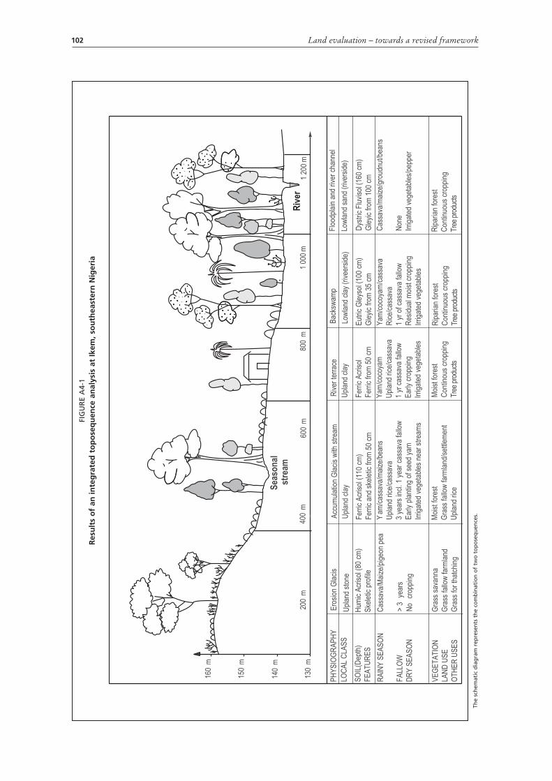
Land evaluation – towards a revised framework102
LOC
AL
CLA
SS
PH
YS
IOG
RA
PH
YA
ccum
ulat
ion
Gla
cis
with
str
eam
Riv
er te
rrac
eB
acks
wam
pF
lood
plai
n an
d riv
er c
hann
el
Upl
and
clay
Upl
and
clay
Low
land
cla
y (r
ivee
rsid
e)Lo
wla
nd s
and
(riv
ersi
de)
Fer
ric A
cris
ol (
110
cm)
Fer
ric a
nd s
kele
tic fr
om 5
0 cm
Fer
ric A
cris
ol
Fer
ric fr
om 5
0 cm
Eut
ric G
leys
ol (
100
cm)
Gle
yic
from
35
cm
Dys
tric
Flu
viso
l (16
0 cm
)
Gle
yic
from
100
cm
Cas
sava
/mai
ze/g
roud
nut/b
eans
Non
e
Irrig
ated
veg
etab
les/
pepp
er
Yam
/coc
oyam
/cas
sava
Ric
e/ca
ssav
a
1 yr
of c
assa
va fa
llow
Res
idua
l moi
st c
ropp
ing
Irrig
ated
veg
etab
les
Yam
/coc
oyam
Upl
and
rice/
cass
ava
1 yr
cas
sava
fallo
w
Ear
ly c
ropp
ing
Irrig
ated
veg
etab
les
Yam
/cas
sava
/mai
ze/b
eans
Upl
and
rice/
cass
ava
3 ye
ars
incl
. 1 y
ear
cass
ava
fallo
w
Ear
ly p
lant
ing
of s
eed
yam
Irrig
ated
veg
etab
les
near
str
eam
s
RA
INY
SE
AS
ON
FA
LLO
W
DR
Y S
EA
SO
N
VE
GE
TA
TIO
N
LAN
D U
SE
OT
HE
R U
SE
S
Moi
st fo
rest
Gra
ss fa
llow
farm
land
/set
tlem
ent
Upl
and
rice
Moi
st fo
rest
Con
tinou
s cr
oppi
ng
Tree
pro
duct
s
Rip
aria
n fo
rest
Con
tinuo
us c
ropp
ing
Tree
pro
duct
s
Rip
aria
n fo
rest
Con
tinuo
us c
ropp
ing
Tree
pro
duct
s
Se
as
on
al
str
ea
m
200
m40
0m
600
m80
0m
1 00
0m
1 20
0m
>3
year
s
No
crop
ping
Ero
sion
Gla
cis
Hum
ic A
cris
ol (
80 c
m)
Ske
letic
pro
file
Upl
and
ston
e
Gra
ss s
avan
na
Gra
ss fa
llow
farm
land
Gra
ss fo
r th
atch
ing
Riv
er
Cas
sava
/Mai
ze/p
igeo
n pe
a
SO
IL(D
epth
)
FE
AT
UR
ES
150
m
140
m
130
m
160
m
FIG
UR
E A
4-1
Res
ult
s o
f an
inte
gra
ted
to
po
seq
uen
ce a
nal
ysis
at
Ikem
, so
uth
east
ern
Nig
eria
The
sch
emat
ic d
iag
ram
rep
rese
nts
th
e co
mb
inat
ion
of
two
to
po
seq
uen
ces.

Annex 4 – Case studies 103
INTEGRATING LAND EVALUATION AND FARMERS’ SOIL SUITABILITY ASSESSMENT IN NORTHWESTERN SYRIAThis section is based on Cools et al. 2003. It illustrates a double-track approach to compare land suitability as perceived by farmers and through scientific judgment. The approach is outlined in Figure A4-3, which shows the main steps in both the farmer-led land suitability assessment and the researcher-led land suitability assessment. Two tools proved their value in linking the farmer-led and researcher-led assessments: integrated transect analysis on a field scale and integrated soil/land unit mapping on a semi-detailed scale.
FIELD SURVEY SCALE:
VILLAGE TO CATCHMENT SCALE:
Participatory rural appraisal(transect walk)
- Land use- Cropping systems
- Farmers'appraisal of soilcharacter and production
Biophysical toposequence survey(along toposequences)
- Physiography- Land cover and vegetation- Soil chemical and physical
characterization
Geographic analysis- Aerial photograph interpretation
of soil-landscapes, land coverand vegetation
- Ground verification- Analysis in GIS environment
Participatory rural appraisal(Village resource mapping)
- Land use- Cropping systems
- Local appraisal of land resources and land use
INTEGRATED TOPOSEQUENCE ANALYSIS
- Relating land use to land cover, physiography and soil- Lindking cropping systems to both biophysical
and farmers'soil characterization- Analysing the dynamics of prevailing land use and
cropping systems along toposequences- Establishing of framework for land resource mapping
taking into account local knowledge
INTEGRATED LAND RESOURCES ANALYSIS
- Verifying and integrating local and scientific knowledgeon land resources and land use through additional
toposequences-Relating toposequence findings to surroundings using GIS and produce maps taking into account
local classification- Relating land use to land cover, and linking land
cover/use patterns to soil landscapes- Analysing the spatial and temporal dynamics of
land cover/use patterns
FIGURE A4-2Integrated land resources analysis taking into account local knowledge
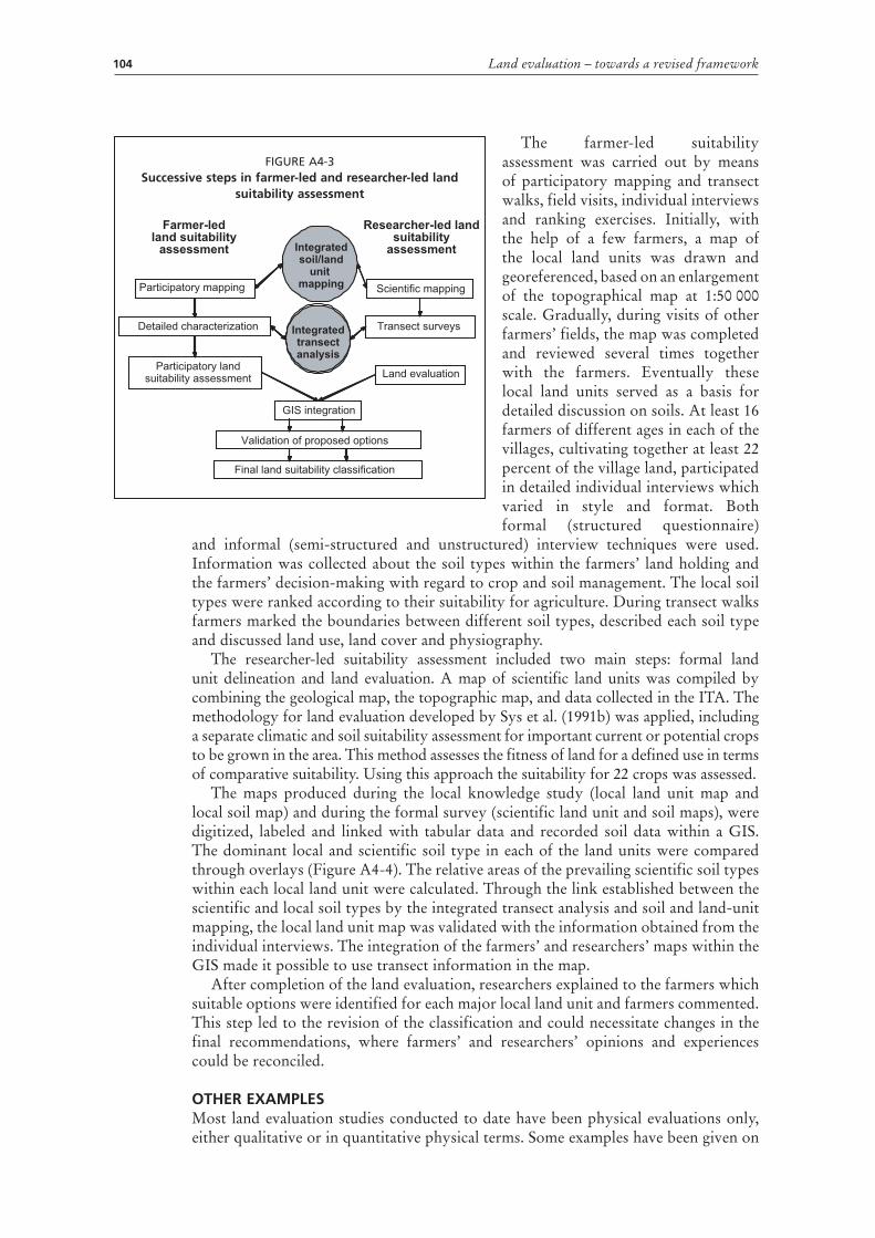
Land evaluation – towards a revised framework104
The farmer-led suitability assessment was carried out by means of participatory mapping and transect walks, field visits, individual interviews and ranking exercises. Initially, with the help of a few farmers, a map of the local land units was drawn and georeferenced, based on an enlargement of the topographical map at 1:50 000 scale. Gradually, during visits of other farmers’ fields, the map was completed and reviewed several times together with the farmers. Eventually these local land units served as a basis for detailed discussion on soils. At least 16 farmers of different ages in each of the villages, cultivating together at least 22 percent of the village land, participated in detailed individual interviews which varied in style and format. Both formal (structured questionnaire)
and informal (semi-structured and unstructured) interview techniques were used. Information was collected about the soil types within the farmers’ land holding and the farmers’ decision-making with regard to crop and soil management. The local soil types were ranked according to their suitability for agriculture. During transect walks farmers marked the boundaries between different soil types, described each soil type and discussed land use, land cover and physiography.
The researcher-led suitability assessment included two main steps: formal land unit delineation and land evaluation. A map of scientific land units was compiled by combining the geological map, the topographic map, and data collected in the ITA. The methodology for land evaluation developed by Sys et al. (1991b) was applied, including a separate climatic and soil suitability assessment for important current or potential crops to be grown in the area. This method assesses the fitness of land for a defined use in terms of comparative suitability. Using this approach the suitability for 22 crops was assessed.
The maps produced during the local knowledge study (local land unit map and local soil map) and during the formal survey (scientific land unit and soil maps), were digitized, labeled and linked with tabular data and recorded soil data within a GIS. The dominant local and scientific soil type in each of the land units were compared through overlays (Figure A4-4). The relative areas of the prevailing scientific soil types within each local land unit were calculated. Through the link established between the scientific and local soil types by the integrated transect analysis and soil and land-unit mapping, the local land unit map was validated with the information obtained from the individual interviews. The integration of the farmers’ and researchers’ maps within the GIS made it possible to use transect information in the map.
After completion of the land evaluation, researchers explained to the farmers which suitable options were identified for each major local land unit and farmers commented. This step led to the revision of the classification and could necessitate changes in the final recommendations, where farmers’ and researchers’ opinions and experiences could be reconciled.
OTHER EXAMPLESMost land evaluation studies conducted to date have been physical evaluations only, either qualitative or in quantitative physical terms. Some examples have been given on
Farmer-ledland suitability
assessment
Participatory mapping
Detailed characterization
Participatory landsuitability assessment
Scientific mapping
Transect surveys
Land evaluation
GIS integration
Validation of proposed options
Final land suitability classification
Integratedsoil/land
unit mapping
Integratedtransectanalysis
Researcher-led landsuitability
assessment
FIGURE A4-3Successive steps in farmer-led and researcher-led land
suitability assessment

Annex 4 – Case studies 105
p.1. The examples given in Chapter 5 of the 1976 Framework are still valid as well for surveys of this kind.
Evaluations that combine physical criteria with economic analysis have been carried out particularly with respect to surveys for irrigation projects. The Guidelines on land evaluation for irrigated agriculture (FAO 1985) outline the method for linking results of physical land suitability (Chapter 6) with economic analysis (Chapter 7).
The following examples include studies that superimpose economic analysis on natural resource survey; those that combine resource survey with participatory methods; and studies combining all three of these techniques in the fully integrated approach set out in the present volume.
FIGURE A4-4Overlay and intersection of local and scientific soil maps of a village in northwestern Syria
Scientific soil map according to the World Reference Base classification system
Local soil map according to the local classification system
Intersection of the local and scientific soil maps, creating new soil mapping units containing attributes from both original maps

Land evaluation – towards a revised framework106
ZimbabweA pioneering early study at reconnaissance scale was the agro-ecological and agro-economic survey of Zimbabwe (at that time Southern Rhodesia) (Vincent et al. 1962). The country was first divided into agro-ecological regions, based on climate and soils, and the predominant farming systems for each identified. These farming systems were then subjected to agro-economic analysis. The survey was very clearly on a two-stage basis, with the two parts conducted by different staff, and published separately.
The next two examples illustrate comprehensive development feasibility surveys, in which all aspects of rural land development are integrated, from physical resource surveys through economic analysis and social or participatory studies (Young 1978).
NepalA survey of the Nawalparisi area was carried out to assess potential for development consequent on construction of road access to this zone (Berry 1974). Physical land suitability was mapped at semi-detailed scale; the suitability classes were linked with agricultural and economic data; the combined data were employed to map suitability (physical and economic) for tea cultivation; and from the maps, potential development areas were identified.
GambiaA study was made of the potential for agricultural development of Gambia, with mapping at a scale of 1:125 000 (Dunsmore et al. 1976). It included natural resource surveys (climate, soils, ecology, hydrology and present land use), technical studies (crop production, animal husbandry, forestry), economic analysis, and social studies (population, land tenure, village studies, social structure). The report ends with 26 pages of recommendations for development.
MexicoLocal knowledge of soils (ethnopedology) was compared with conventional soil survey in a study in Mexico (Ortiz-Solorio & Gutierrez-Castorena 2001). At a detailed scale, local knowledge was transformed into a soil map that was more precise and accurate than similar scientific maps at the local scale. At the regional scale, more problems were encountered. Farmers in Mexico possess cartographic knowledge but their knowledge is conceptual. They know where to find different land classes but they do not elaborate maps. There was a need for a base map, a kind of topographic map, on which the local land and soil units could be projected.
BangladeshLand evaluation surveys of immense detail were carried out in Bangladesh (Brammer et al. 1988). In the first instance, these consisted of physical evaluation linked with crop suitability, but it should be noted that the latter was not based only on physical criteria but in addition, considerable use with made of local knowledge. The results were subsequently applied to a wide range of development questions, for example site selection for experimental stations, and village agricultural development plans (Brammer 2002). Examples are given of how to scale down reconnaissance maps to village (thana) scale, the detailed work at village scale being conducted by the local agricultural extension officer.
East Africa and BangladeshIn research to develop ways of systematizing locally derived information, ethnographic methods were used to obtain local soils knowledge and its socio-cultural context, accompanied by scientific surveys of soils and agro-ecosystems (Payton et al. 2003). The local knowledge, much of it not initially spatial in nature, was compiled in a

Annex 4 – Case studies 107
relational database using CAQDAS, a computer-assisted qualitative data analysis software package (QSR 1997). In the case of Bangladesh, the information was coded for local Bengali words (e.g. bele, balu for ‘sandy’). The use of a database provides a tool by which the original scripts of farmers’ interviews can be searched, by natural as well as social scientists.
Uganda and the Republic of TanzaniaOn a research basis, an attempt was made to compare surveys of land resources, by soil scientists, and of local knowledge, by social scientists. The work was carried out at sites in Uganda and Tanzania (Payton et al. 2003). In order to keep the respective assessments independent, the two groups deliberately refrained from exchanging information. Comparing mapped areas as surveyed by soil surveyors with those obtained by farmers’ knowledge, the correspondence was fair for low-catena and valley-floor soils, but showed a poor correspondence with respect to differentiation of the upper and mid-catenary areas.

FAO TECHNICAL PAPERS
FAO LAND AND WATER DISCUSSION PAPERS
1. A perspective on water control in southern Africa – support to regional investment initiatives, 2003 (E)
2. On-farm composting methods, 2003 (E, F)
3. Payment schemes for enviornmental services in watersheds / Sistemas de pago por servicios ambientales en cuencas hidrográfi cas, 2004 (E/S)
4. Drought impact mitigation and prevention in the Limpopo River Basin – a situation analysis, 2004 (E)
5. Water desalination for agricultural applications, 2006 (E)
6 Land evaluation – towards a revised framework, (E) 2007. Only available in PDF format at http://www.fao/ag/agl/public.stm.
Availability: April 2007
Ar – Arabic Multil + MultilingualC – Chinese * Out of printE – English ** In prep a ra tionF – FrenchP – PortugueseS – Spanish
The FAO Technical Papers are available through the authorized FAO Sales Agents or directly from Sales and Marketing Group, FAO, Viale delle Terme di Caracalla, 00153 Rome, Italy.

6
ISSN 1729-0554
LAND ANDWATER
DISCUSSIONPAPER
TC/D/A1080E/1/04.07
Land evaluation Towards a revised framework Land evaluation Towards a revised framework
LAND AND WATER DISCUSSION PAPER
6
This report reviews the concern raised that land should not only be
evaluated for the goods it provides, but also for the services it
renders. Before updating the Framework for Land Evaluation this
publication serves as a discussion paper that draws attention to the
various facets related to climate change, biodiversity and
desertification in addition to new tools and approaches that are
presently available to undertake land evaluation.
Land evaluationTowards a revised framework