01115 Tarka Trail
28
Tarka Trail Circular Routes www.devon.gov.uk/prow www.visitdevon.co.uk the place to be naturally active
Transcript of 01115 Tarka Trail
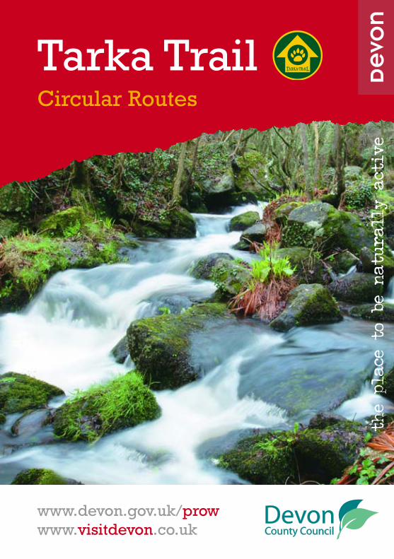
Tarka TrailCircular Routes
www.devon.gov.uk/prowwww.visitdevon.co.uk
the place to b
e na
tura
lly
active

The Tarka Trail is 180 miles long andfollows in the footsteps of thecharacter Tarka the Otter from HenryWilliamson’s famous novel. The Trailsplits into 2 loops centred atBarnstaple and is a great way toexplore the world class environment ofNorth Devon’s UNESCO Biosphere thatstretches from Dartmoor to Lundy andExmoor to Hartland. This bookletguides you around 11 circular walksfrom the Trail.
At a glance
• 180 mile Tarka Trail
• North and South loops that take inDartmoor and Exmoor NationalParks and the North Devon CoastArea of Outstanding Natural Beauty
• 31 miles of Shared-Use-Section onformer railway line
• 18 miles of Tarka Railway Line
• 55 miles is shared with the SouthWest Coast Path
• 11 easy to follow way markedcircular walks, 9 with easy access topubs or cafes
North LoopGoing counter-clockwise fromBarnstaple, the North Loop headsinland along the tidal section of theRiver Taw. The Trail rises up throughlittle villages with cob and thatchedcottages, takes in remote farms andfollows rocky, deep cut lanes andwooded valley paths until it reachesthe high plateaus of Exmoor.
As the route descends to the coast itjoins the River Lyn tumbling overgranite boulders and winding downthrough the narrow, ancient woodedvalleys. At Lynmouth the Tarka Trailfollows the South West Coast Path allthe way along cliff tops, visitingcoastal towns and villages, andcrossing beaches before tracking backalong the Taw estuary to Barnstaple.
“Swimming towards the sunset, Tarkawent westwards, under the toweringcliffs and waterfalls in whose fernysides he liked to rest by day.”
from Henry Williamson’s “Tarka the Otter”
2
Tarka TrailCircular Routes

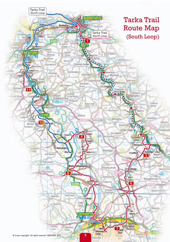
South LoopHeading south west from Barnstaple,the Trail continues alongside theexpansive saltmarsh, mudflats andsandbanks of the Taw/Torridge Estuaryto Bideford. This is part of the Shared-Use-Section that covers 31 miles offormer railway line between Brauntonand Meeth. The Shared-Use-Sectionhas a tarmac surface as far asWatergate and is open for bicycles,wheelchairs and walkers. Horses arewelcome between Torrington andMeeth.
From the ancient port town ofBideford the Trail travels inland leavingthe wide rivers and their estuariesbehind and follows bubbling streamsthrough woodlands and flower-richculm grassland before finally arrivingat the edge of the high moor. TheRiver Taw rises on Dartmoor and the
Trail joins it and returns with it,passing through the gently rollingcountryside to meet the Tarka RailwayLine at Eggesford. The railway line isthe final leg of the South Loop; criss-crossing over the twists and turns ofthe River as it heads back toBarnstaple.
“…time flowed with the sunlight ofthe still green place… the ottershunted and ragrowstered for manydays under the high wooded hillsbelow which the river wound andcoiled like a serpent.”
from Henry Williamson’s “Tarka the Otter”
3
Phot
o: D
avid
Cor
ke
Photo: David Corke

1
23
4
Tarka TrailSouth Loop
Tarka TrailSouth Loop
Tarka Trail Route Map (North Loop)
4
Bishop’s Tawton . . . . . . . . 6
Tordown . . . . . . . . . . . . . . 8
Charles . . . . . . . . . . . . . . 10
Croyde to Saunton . . . . . 12
Coldridge . . . . . . . . . . . . 14
North Tawton . . . . . . . . . 16
Sticklepath . . . . . . . . . . . 18
Hatherleigh . . . . . . . . . . . 20
Dolton . . . . . . . . . . . . . . . 22
East Yarde . . . . . . . . . . . . 24
Monkleigh . . . . . . . . . . . 2611
10
9
8
7
6
5
4
3
2
1
Circular Walk Locations
Map Key
Tarka Trail (footpath)
Tarka Trail (shared use section)
Tarka Line (railway)
© Crown copyright. All rights reserved. 100019783. 2011
7
9
1
8
11
10
6
5
Tarka TrailNorth Loop
Tarka TrailNorth Loop
Tarka Trail Route Map (South Loop)
5© Crown copyright. All rights reserved. 100019783. 2011

Bishop’s TawtonOverview
Location: Bishop’s Tawton
OS map: 139 Bideford, Ilfracombe &Barnstaple
Length: 6 km/3.7 miles
Length of Tarka Trail section:2.25 km/1.4 miles
Time: 3 hours
Sat nav postcode: EX32 0DQ
Highlights:
• Spectacular views stretching fromHartland Point to Braunton Burrowsand inland along the river valley
• Tranquil walk along a wooded rivervalley
Walking conditions vary from tarmaccountry lanes to muddy woodlandpaths and gravelled paths overCodden Hill.
Details
This walk takes you from Bishop’sTawton along a partly wooded valley,past a quarry and back over CoddenHill for one of the best views in NorthDevon. On a clear day you can seeLundy, Hartland and Morte points onthe coast and Exmoor and Dartmoor.At the top of Codden Hill there is amonument to Caroline Thorpe, wife ofex-MP Jeremy Thorpe, who died in1970 aged 32. Bishop’s Tawton is asmall village in the valley of the RiverTaw, about three miles south ofBarnstaple. The church dates fromaround the 14th century and thefarmhouse by the church was aresidence of the Bishops of Exeter untilthe Tudor period.
The Chichester Arms pub
The walk starts at the Chichester Armspub, which dates from the 15thCentury and has kept much of itsoriginal character. Head up Sentry laneand then along the path marked TarkaTrail which will take you through fieldsand broad leafed woodland.
The path follows a tributary of theriver Taw where, if you look carefully,you can see evidence of the industrialworks associated with the lime kilnsactive in this area until the late 1800s.When you reach Higher Venn, turnright up the hill towards HigherBableigh. You then take the un-metalled road up to Codden Hill carpark. From here you follow the pathpast Codden Beacon and back toBishop’s Tawton.
6
1
Photo: David Corke

© Crown copyright. All rights reserved. 100019783. 20117
Bishop’s Tawton Map
Photo: David Corke

TordownOverview
Location: Tordown Farm
OS map: OL9 Exmoor
Length: 2.9 km/1.8 miles or 1.6 km/1 mile
Length of Tarka Trail section: 0.5 km
Time: 1 hour 15 mins/35 mins
Sat nav postcode: EX32 0QY
Highlights
• Opportunity to see and walk arounda traditional Devon Farm that serveshome made Cream Teas
• Panoramic viewpoint taking inExmoor and Dartmoor NationalParks and the coast
• The Nature Trail takes you throughsteep hidden valleys and nativewoodland
• Opportunity to take a long or shortwalk
Details
Go to Tordown Farmhouse for a mapand to let the farmer know you arevisiting. The walk starts at thefarmhouse and heads out across thefields and woodlands, meeting theTarka Trail in the bottom of the valleybefore heading back up over the hillto the Farm. There are green markerson the gates that will help to guideyou around this circular walk.
From the roadside go to the other sideof the farm buildings and through thegate on your right-hand side at thestart of a farm track. Once in the field,keep to your right and go throughanother gate that takes you through aformer orchard out onto an ancientsteep-sided lane. Go left up the laneto a gate on your left. Look out forthe viewpoint marker post at the topof the slope. Going over the brow ofthe hill to your left, follow the routeout over the fields and down into thevalley to meet the Tarka Trail. Turn leftalong the wooded Tarka Trail greenlane until you can turn left againthrough the farm gate back into thefields and up the steep hill throughthe fields and back to the Farmhouse.Do remember to close the gatesbehind you!
2
8
Photo: David Corke
Photo: David Corke

9
Tordown Map
© Crown copyright. All rights reserved. 100019783. 2011
Photo: David Corke
Phot
o: D
avid
Cor
ke
Details
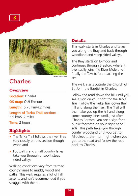
This walk starts in Charles and takesyou along the Bray and back throughwoodland and steep sided valleys.
The Bray starts on Exmoor andcontinues through Brayford where iteventually joins the River Mole andfinally the Taw before reaching thesea.
The walk starts outside the Church ofSt. John the Baptist in Charles.
Follow the road down the hill until yousee a sign on your right for the TarkaTrail. Follow the Tarka Trail down thehill and along the river. The Trail willthen take you up the hill and alongsome country lanes until, just afterCharles Bottom, you see a sign for apublic footpath on your right handside. This path takes you throughconifer woodland until you get toMiddlecott, then turn right when youget to the road and follow the roadback to Charles.
CharlesOverview
Location: Charles
OS map: OL9 Exmoor
Length: 6.75 km/4.2 miles
Length of Tarka Trail section:3.5 km/2.2 miles
Time: 2 hours
Highlights
• The Tarka Trail follows the river Brayvery closely on this section thoughwoodland
• Footpaths and small country lanestake you through unspoilt steepsided valleys
Walking conditions vary from tarmaccountry lanes to muddy woodlandpaths. This walk requires a lot of hillascents and isn’t recommended if youstruggle with them.
10
3
Photo: David Corke

11
Charles Map© Crown copyright. All rights reserved. 100019783. 2011
Phot
o: D
avid
Cor
ke

Croyde to Saunton Overview
Location: Saunton Sands
OS map: 139 Bideford, Ilfracombe andBarnstaple
Length: 6 km/3.7 miles
Length of Tarka Trail section:2.5 km/1.5 miles
Time: 2 hours
Sat nav postcode: EX33 1LZ
Highlights:
• Stunning views of the Bay andBraunton Burrows
• Walk along Croyde beach
Details
This walk takes you along Croydebeach and the South West Coast Pathbefore climbing steeply up and overSaunton Down before looping backinto Croyde through woods andcountry lanes.
Croyde is one of the most popularvillages in Devon for families, surfersand walkers. The village is charmingwith its thatch and cob buildings,surrounding hills, sand dunes andbeautiful beach. There are manyplaces to stay, eat and drink and little
shops to explore. Saunton is lessdeveloped than Croyde with theamenities centred round the beach carpark. From the top of Saunton Downyou have one of the best views inNorth Devon looking over BidefordBay and Braunton Burrows, one of thebiggest dune systems in the UK. It isthe core of North Devon’s UNESCOBiosphere Reserve.
There is a public car park located inthe centre of the village but this walkstarts at Billy Budds pub in Croyde.From Billy Budds follow the footpathto the beach and then turn left. Followthe Coast Path along the beach andcliffs to the road just beyond the oldCoastguard lookout. Turn left alongthe road back towards to Croyde andcross when you see the footpath signon your right. This path will take youto Saunton where there is a beachshop, café and restaurant. Cross theroad to visit the beach and amenitiesor follow the footpath up the hillmarked ‘Public Footpath Croyde’.When you get further up the hill turnright to pass behind the abandonedbuilding - sign posted ‘Coast PathSaunton’. Follow the track until yousee a footpath sign pointing over thehill and then look out for signs leadingyou through the field (they areattached to 7ft posts with yellowpaint). On the other side of the hillyou join a wooded path that will takeyou all the way back to the village.
12
4

© Crown copyright. All rights reserved. 100019783. 2011
Croyde to Saunton Map
13
Photo: David Corke

ColdridgeOverview
Location: Coldridge
OS map: 113 Okehampton
Length: 8 km/5 miles
Length of Tarka Trail section:3.25 km/2 miles
Time: 2 hours 45 mins
Sat nav postcode: EX17 6AX
Highlights:
• Brushford church is a great place tohave lunch and enjoy the views ofthe surrounding countryside
• Wooded valley walks along the riverTaw
Walking conditions vary from tarmaccountry lanes to muddy woodlandpaths. This walk would be mostenjoyable during good weather due tosections of the paths becoming verymuddy and wet.
Details
Coldridge is a small village about 10miles from Crediton. The settlementhas been around since Norman timesand was mentioned in the DomesdayBook of 1086. St. Matthew’s has manyinteresting features, especially the15th century carved wooden screenwith its unique ‘carver’s joke’, and iswell worth a look. Although thevillage doesn’t have a pub there is asmall post office selling refreshments.The nearest pub is in Lapford, which isa 15 minute drive away.
After parking by St. Matthew’sChurch, follow the road towardsEggesford until you reach a path onyour left signed as a bridleway. Followthis path until you cross over a countrylane at which point the path becomesthe Tarka Trail. Follow the Trail acrossBrushford Bridge and up to BrushfordChurch, which is worth visiting for itsair of remoteness, its beautifulsituation and its chancel screen. Followthe footpath past Brushford Church allthe way back to Park Mill Bridgewhere you turn right and follow thesigns back to Coldridge.
14
5
Photo: David Corke

Coldridge Map
15
© Crown copyright. All rights reserved. 100019783. 2011
Photo: David Corke

North TawtonOverview
Location: North Tawton
OS map: 113 Hatherleigh, NorthTawton & Lapford
Length: 4.5 km/2.8 miles
Length of Tarka Trail section:2.25 km/1.4 miles
Time: 2 hours
Sat nav postcode: EX20 2DT
Highlights:
• The footbridge over Bailey’s Fordallows close up views of the riverTaw
• Walking along the river bank on theTarka Trail for over a mile
Walking conditions vary from tarmaccountry lanes, muddy footpaths andgrassy fields. Appropriate footwear isessential for this walk due to muddysections after rain.
Details
This walk takes you through NorthTawton, through the surroundingcountryside and then back along theriver Taw. North Tawton is a rural townsituated on the river Taw, close toDartmoor National Park. It has been
inhabited since Roman times when itwas a military camp and crossing pointover the river. By the end of the 12thcentury it was a prosperous markettown. The tower of the St. Peter’sChurch was built around this timealthough the rest of the church datesfrom the 14th-15th centuries. In 2005,North Tawton was chosen as thefilming location for Jennifer Saunders’BBC television series Jam & Jerusalem.
From the start of the walk at TheWhite Hart in North Tawton turn rightonto Letheren’s Lane, which is clearlymarked as a footpath. Follow this pathuntil you reach Yeo but do not crossYeo Bridge. Instead, follow the signmarked un-metalled road until youreach Bailey’s Ford and cross the riveron the footbridge. From here the pathis sign-posted Tarka Trail all the wayback to the main road bridge intoNorth Tawton.
16
6Photo: David Corke

North Tawton Map
17
© C
row
n co
pyri
ght.
All
righ
ts r
eser
ved.
100
0197
83. 2
011
Photo: David Corke

SticklepathOverview
Location: Sticklepath
OS map: OL28 Dartmoor
Length: 4.8 km/3 miles
Length of Tarka Trail section:3.2 km/2 miles
Time: 2 hours 30 mins
Sat nav postcode: EX20 2NW
Highlights:
• Explore the historic villages ofSticklepath and Belstone
• Views of the Taw valley, Belstoneand the surrounding countryside
Walking conditions vary from tarmaccountry lanes to muddy woodlandpaths.
Details
Sticklepath is a village set amid thebeautiful Dartmoor countryside. Itsname derives from the Saxon ‘staecle’,meaning ‘steep’, as it lies at the footof a high mount. Sticklepath is hometo Finch foundry, the last remainingwater-powered forge in England thatin its heyday made 400 tools a day;sickles, scythes and shovels for WestCountry farmers and miners.
Belstone is a quaint little village thathas kept much of its character andarchitecture. The village churchoriginated in 1260 but the presentbuilding dates from the 14th and 15thcentury though there was a majorrestoration in 1881. The churchcontains an incised granite cross thathas been dated to between the 7thand the 9th centuries. Belstone alsohas its own ‘jail’, although it is actuallya holding pen for stray sheep.
This walk starts outside the FinchFoundry in the centre of Sticklepath.With the foundry on your left, headup the road and turn left down thelane where the main road bends tothe right. After about 500 metres onthis lane take the track to your leftwhich opens out into an informalparking area. Follow this track alongthe north of the river to Belstonevillage. Through Belstone keep left,past the ‘jail’ out onto the wide-openvillage common with views up toCosdon Hill and out over the Cleave.Find the path over the hill beforedropping down to the bridge over theriver. Follow the path up the hill to thepillow mounds and out across the sideof the open hill to the edge of thewalled Skaigh Warren. Keep the wallon your left until you turn left throughthe gate and follow the bridleway offthe moor back down into the woodsand round onto the road atSticklepath. A short walk up the roadto your left takes you back to thefoundry.
7
18

Sticklepath Map
19
© Crown copyright. All rights reserved. 100019783. 2011
Photo: David Corke

HatherleighOverview
Location: Hatherleigh
OS map: 113 Hatherleigh, NorthTawton & Lapford
Length: 6.5 km /4 miles
Length of Tarka Trail section:1.5 km/1 mile
Time: 2 hours
Sat nav postcode: EX20 3JN
Highlights:
• Hatherleigh Monument
• Views of Hatherleigh moor andDartmoor
Walking conditions vary from tarmaccountry lanes to open fields.
Details
Hatherleigh stands at the meetingpoint of the Rivers Lew and Torridgeand was founded by monks over athousand years ago. It has remainedan important market town ever sincewith a market being held everyTuesday. The town has managed tokeep its original charm and is full ofindependent shops and artists sellingtheir wares making a refreshingchange from chain stores.
20
It is well worth exploring before youstart the walk.
The walk starts at the George pub thatdates from 1450, though it was muchrebuilt after a fire in 2008. Despitethis, like much of Hatherleigh, it hasmanaged to keep its original character.From the George head along MarketStreet, turn left onto Oakfield Roadand then right onto Sanctuary Lanewhere the Tarka Trail begins. Followthis lane until you see a bridleway sign
on your right. Halfway up this paththere is a brick viewing platform calledBelvedere Castle with stairs leading tothe top from where there are superbpanoramic views across a patchworkof woods and farmland to Dartmoor.When you reach the end of the laneturn left and keep on the left handside of the road until you reach theWilliam Morris monument. Thisobelisk was erected to commemorateWilliam Morris who was acommanding officer in the Crimean
8
Photo: David Corke

War and was injured in the Charge ofthe Light Brigade in 1854. From themonument, cross the road and rejointhe Tarka Trail across HatherleighMoor. Follow the Tarka Trail until itreaches the road and then stay on themoor by following the footpath.Eventually this will bring you to a smalllane which will take you all the wayback to the start of the walk in thecentre of Hatherleigh.
Hatherleigh Map
21 © Crown copyright. All rights reserved. 100019783. 2011
Photo: David Corke
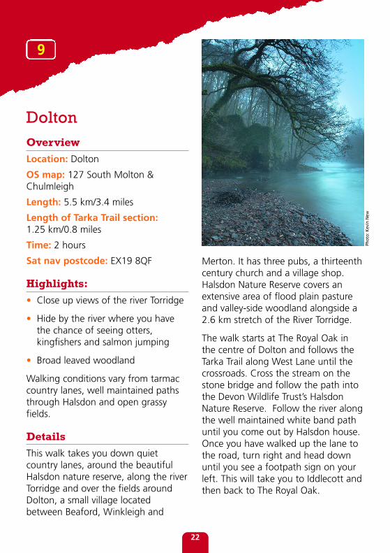
DoltonOverview
Location: Dolton
OS map: 127 South Molton &Chulmleigh
Length: 5.5 km/3.4 miles
Length of Tarka Trail section:1.25 km/0.8 miles
Time: 2 hours
Sat nav postcode: EX19 8QF
Highlights:
• Close up views of the river Torridge
• Hide by the river where you havethe chance of seeing otters,kingfishers and salmon jumping
• Broad leaved woodland
Walking conditions vary from tarmaccountry lanes, well maintained pathsthrough Halsdon and open grassyfields.
Details
This walk takes you down quietcountry lanes, around the beautifulHalsdon nature reserve, along the riverTorridge and over the fields aroundDolton, a small village locatedbetween Beaford, Winkleigh and
Merton. It has three pubs, a thirteenthcentury church and a village shop.Halsdon Nature Reserve covers anextensive area of flood plain pastureand valley-side woodland alongside a2.6 km stretch of the River Torridge.
The walk starts at The Royal Oak inthe centre of Dolton and follows theTarka Trail along West Lane until thecrossroads. Cross the stream on thestone bridge and follow the path intothe Devon Wildlife Trust’s HalsdonNature Reserve. Follow the river alongthe well maintained white band pathuntil you come out by Halsdon house.Once you have walked up the lane tothe road, turn right and head downuntil you see a footpath sign on yourleft. This will take you to Iddlecott andthen back to The Royal Oak.
22
9
Phot
o: K
evin
New

Dolton Map
23
© Crown copyright. All rights reserved. 100019783. 2011
Photo: Kevin New

East YardeOverview
Location: East Yarde
OS map: 126 Clovelly & Hartland
Length: 7.25 km/4.5 m
Length of Tarka Trail section:2 km/1.25 miles
Time: 1 hour 45 mins
Sat nav postcode: EX38 8QA
Highlights:
• Spectacular views of thesurrounding countryside and ofDartmoor in the distance
• Walk along the Tarka Trail throughbroad leaved woodland and overStowford Moor
Walking conditions vary from tarmaccountry lanes to muddy woodlandpaths and the well maintained TarkaTrail. The footpath section of this walkcan become extremely wet and muddyafter rain, so wear appropriatefootwear or undertake the walk ingood weather.
Details
This walk will take you over farmlandand then round country lanes withspectacular views of the surroundingcountryside before bringing you backto East Yarde along the Tarka Trail.East Yarde was once an intermediatehalt on the initially privately run NorthDevon and Cornwall Junction LightRailway, constructed in 1925 to serveclay works along its route. Theplatform can still be seen on the otherside of the road from the car park andis the highest point of the formerrailway. The last passengers to use theline were in 1965 but it remained inuse for ball clay until 1982. The linenow forms part of the Tarka Trail.
The walk starts at Yarde Orchard, anaward winning Cafe and bunkhouse.Follow the road up the hill until yousee a footpath sign on your right.Follow this track until you reach awooden gate that leads to a field.Instead of passing through the gate,continue onwards keeping the hedge
24
10
Photo: David Corke

Follow this road until you reachBagbear Holt where you turn rightonto the Tarka Trail once more. Followthe Tarka Trail up the hill until youreturn to East Yarde.
to your left until you reach the top ofthe hill and a stile. Go over the stileand follow the footpath into PetersMarland. Follow the sign markedLangtree and walk up the lane untilyou reach Berry Cross and then turnright towards Stowford.
© Crown copyright. All rights reserved. 100019783. 201125
East Yarde Map

MonkleighOverview
Location: Monkleigh
OS map: 126 Clovelly & Hartland
Length: 8.75 km/5.45 miles
Length of Tarka Trail section:2 km/1.25 miles
Time: 3 hours
Sat nav postcode: EX39 5JS
Highlights:
• The art work adds to the attractionof this wooded part of the TarkaTrail
• Views of the Torridge valley
Details
This walk takes you through smallvillages and through open countrysidebefore walking back along the TarkaTrail past some of its most popular artwork. Monkleigh is a small villagelocated between Bideford andTorrington. St. George’s, its church, isthought to originate from around1423 though additional parts wereadded in 1537 before a Victorianrestoration in 1862. Watergate wasonce an intermediate halt on theinitially privately run North Devon and
Cornwall Junction Light Railway,constructed in 1925 to serve clayworks along its route.
The walk starts at the Bell Inn inMonkleigh, which is located on themain road through the village. Headdown the road towards the churchand then turn right by the communitycentre and follow the footpath signsover the fields until you reach a smalllane. Turn left down the lane until yousee a footpath sign on your right handside. This path takes you towardsFrithelstock. When it meets the roadyou can detour left to explore thehamlet including the remains of itspriory begun in 1220 and dissolved in1536, or continue right down the roaduntil you see a footpath sign on yourleft hand side. Follow this path all theway down to Watergate and join theTarka Trail towards Torrington. Followthe Trail until you see a bridleway signon your left in sight of the iron bridgeacross the Torridge. Follow thebridleway back up to the road thatleads all the way back to Monkleigh.
26
11
Photo: David Corke

© Crown copyright. All rights reserved. 100019783. 2011
Monkleigh Map
27
Photo: David Corke

Cover photo: David Corke
JN01115 • Corporate Communications Design Service
This is printed on recycled paper
When you have finishedwith it please recycle and
help the environment.
Devon County Council has made every effort to ensure that thecontents of this publication are accurate at the time of printinghowever walks and rides are undertaken at your own risk. June 2011
For more information on walks which are accessible to all, visitwww.devon.gov.uk/accessforall
For visitor information including accommodation availability visitwww.visitdevon.co.uk
If you enjoy Devon'scoast and countryside . . .
Why not order one of our free booklets at www.devon.gov.uk
If you would like a summary of this ina different format such as large print,Braille or tape, or in a differentlanguage, please contact our CustomerService Centre on 0845 1551 004 oremail: [email protected]