Advice on the Charcoal Briquette Stove in the Khumbu Region, Nepal
Annals 0/ Glacioiogy 8 1986 © International Glaciological Society
TOPOGRAPHIC CHARACTERISTICS IN THE ABLATION AREA OF THE
KHUMBU GLACIER, NEPAL HIMALAYA
by
O. Watanabe
(National Institute for Polar Research, Jtabashi, Tokyo 173, Japan)
and
S. Iwata
(Department of Geography, Tokyo Metropolitan University, Setagaya, Tokyo 158, Japan)
and
H. Fushimi
(Lake Biwa Research Institute, Otsu, Shiga 520, Japan)
ABSTRACT Topographic sketch mapping of the whole ablation area
of the Khumbu Glacier, East Nepal Himalaya, is performed, using a simple, stereo-photogrammetric method. This map shows that the surface morphology can be classified into II morphologic characteristics. Depending on their distribution and combination, the ablation area can be divided into four morphologic areas. Detailed maps, on a scale of I: I 000-2500, of these four areas indicate that the distribution and combination of these I1 morphologic characteristics result from thickness of the debris cover supraglacial streams and ponds, and glacier dynamics. Th~ irregularity in the ablation area of the Khumbu Glacier can be considered to be a consequence of the mass balance between rate of ice charge from upstream and irregular distribution of ablation rate, depending on debris-cover characteristics in situ.
INTRODUCTION One of the most conspicuous morphological features on
the southern slope of the Himalayan Mountains is the abundance of debris-covered glaciers. Debris-covered areas on glaciers are common on valley type glaciers with large ice tongues, but on smaller valley glaciers and cirque glaciers, debris-covered areas are small or lacking. On the other hand, on the northern slope of the Himalayan Mountains, including the southern part of the Tibetan Plateau, most glaciers have ablation areas without supraglacial debris or with small debris-covered areas.
The Khumbu Glacier has a 10 km-long, debris-covered area. The debris-covered area shows complex morphological features, considered to be a consequence of morphological processes in situ. In order to make clear the process of formation of surface features, a topographic survey and mapping of surface morphology were carried out on the Khumbu Glacier during the monsoon season (JuneSeptember) of 1978.
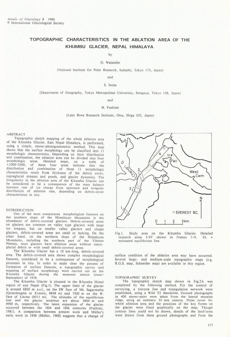
The Khumbu Glacier is situated in the Khumbu Himal region of east Nepal (Fig. I ). The upper limit of the glacier is around 6800 m a.s.l., on the SW face of Mt. Sagarmatha (Qomolangma or Everest, 8848 m) and 7500 m on the W. face of Lhotse (8511 m). The altitudes of the equilibrium line and the glacier terminus are about 5600 m and 4900 m, respectively. The latest expansion of the glacier occurred between the 16th and 18th centuries (Fushimi, 1981). A comparison between present work and Muller's early work in 1956 (Muller, 1968) suggests that a change of
o EVEREST acl o 2 3km
L' _--''--_.L' _--"
Fig.l. Study area on the research areas I-IV shown estimated equilibrium line.
Khumbu Glacier. in frames 1-4.
Detai led EL
surface condition of the ablation area may have occurred. Several large- and medium-scale topographic maps (e.g. R.G.S. map, Schneider map) are available in this region.
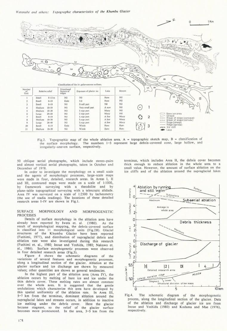
TOPOGRAPHIC SURVEY The topographic sketch map show n in Fig.2A was
completed by the following method. For the co ntro l of surveying, a traverse line and triangulation network were established, using a Wild T2 theodolite. Ground photographs in 400 stereo-pairs were taken from the late ral morai ne ridge, us ing an ordinary 35 mm camera. These cove r the whole ablatio n area and the positions of the key forms on the glacier were fixed graphically on the map. Though contour lines could not be drawn, details of the lanMorms were drawn from these ground photographs and from the
177
lI"atallabe alld others: /'opoglaphlc characteristics of the Khumbu Glacier
Number of
Unit
JO
11
Relative relief
Small 0-1501
Small 0-10
Small 0-- 10
f\·1cdiUnl lO-lO Medium 10-30
Large 20-40
Small 0-10
M ed ium 10-30
Large 20-40
Small 0-15
Medium lO-lO
Classificat ion o f the irr..gu lar-unevcn surfaces.
Directional fea ture of Exposure of glacier ice ridges
Nil Nil
Exist l\il
Nil S nail part Nil Very small parI N il L l.fgC pari
Nil lHge part N;I Lusc part Nil LMgC parI
Nil Large par i
Ex.ist Whole
Nil \\ hole
Lake Stream
Rare Nil <5
Rare Nil
Nil Nil
0 A new Nil Many Nil
Many Nil c::> Bare ice area A few Many a 2 St r eam
Break of slope (concave) A few Many Break of slope (convex) A few Many
~ -- Ridge (sharp)
Rare Rarr: 3 -----. Ridge (genlle) ~ lee cliff
H.are Rar,: -Lake
Fig.2. Topographic map of the whole ablation area. A = topographic sketch map , B = classification of the su rface morphology. The numbers 1-3 represent large debris-covered cone, large hol low, and irregularly- uneve n surface, respectively.
50 oblique ae rial photographs, which include stereo-pairs and almost vertical aerial photographs, taken in October and December of 1978.
In order to in vest igate the morphology on a small scale and the age nts of morphologic processes, large- scale maps were made in four, detailed, research areas. In Areas I, " and Ill , co ntoured maps were made on a scale of 1:1000, by framework surveying with a theodolite and by plane-table topog raphica l surveying with a telesco pic alidade. Area IV was surveyed on a scale of I :2500 by tacheometry (the use of stadia readings) . The locations of these detailed researc h areas I-IV are shown in Fig.!.
SURFACE MORPHOLOGY AND MORPHOGENETIC PROCESSES
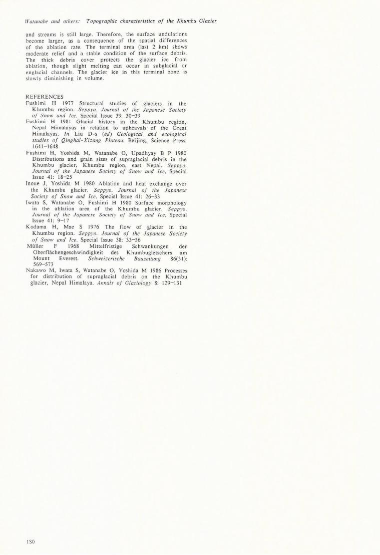
Details of surface morphology in the ablation area have already been reported by Iwata et. al. (1980). As the res ult of morphological mapping, the debris-covered surface is classified into II morphological units (Fig.2B) . Glacial structures of the Khumbu Glacier have been reported (Fushimi, 1977), and distribution of supraglacial debris and ablation rate were also investigated during this research (Fushimi et. aI., 1980; Inoue and Yoshida, 1980; Nakawo et. aI., 1986). Surface morphogenetic processes were observed in four detailed research areas (Fig.3).
Figure 4 shows the schematic diagrams of the variations of several features and morphogenetic processes, along a longitudinal section of the glacier. Ablation at the glacier surface and ice discharge are shown by measured values; other quantities are shown as general tendencies.
In the highest part of the ablation area (Area IV), the ablation occurs by melting of bare ice and ice under the thin debris cover. These melting rates are almost constant over the whole area. It is suggested that the gentle undulations which characterize this area have developed by this spatial uniformity of the ablation rate. In Area Ill, 5-7 km from the terminus, dominant ablation around the supraglacial lakes and streams occurs, in addition to inactive ice melting under the debris cover. Here the glacier became stagnant , so the relief of the glacier surface becomes more pronounced . In the area, 3-5 km from the
terminus , which includes Area 11 , the debris cover becomes thick enough to reduce ablation in the whole area to a small value. However, the amount of surface ablation on the ice cliffs and of the ablation around the supraglacial lakes
>- + Ablation by runni,'Jn.»-_-_ ..... .~ and still water ~ --./'" 5 .£ 0 ..?-- ___ u~~a c ("
Max;mum --_~ubaerial ablation -->- 4 .. ~ 2
0
3 E
2
0 L'
6 >-"-c ~ 4 '2 . 2
o
A .... era ge in
whole area
Discharge of glac i er
III \2\ 131 De ta iled rpsearch a rea
mor aine \ \
Stagnant \ l ower ' .... Struct ura l di vi sion o f ice mass
5
---
4 I :..--::;;::
10km
FigA. The schematic diagram of the morphogenetic process, along the longitudinal sec tion of the glacier. Data of the ablation and discharge of glacier ice are from Tnoue and Yoshida (1980) and Kodama and Mae (1976), respectively.

IVatallabe alld others: Topographic characteristics oJ the Khumbu Glacier
L ___ J Bare ice area 2,!;:?.J~ Debris covered area
lee ridge and ice pinnacle Debris .collered ridge and knoll
.il1I1I11IlIIlh lee cliff in debris covered area
~5tream _ Lake
::~: Large boulders
AREAII
Fig.3. Topog raphic maps of the four, detailed research areas.
o Large block Fluvial fine materials
,I, gl~l ~~~~!~;~ogn p'Jin!s c'''' with altitudes
@y:fj) Hollows ~ Break of slope
(convex) Break of slope (concave)
l79
Wo/aI/obe lll/d others: Topographic characteristics of the Khumbu Glacier
and streams is still large . Therefore, the surface undulations become large r, as a consequence of the spatial differences of the ablation rate. The terminal area (last 2 km) shows moderate relief and a stable condition of the surface debris. The thick debris cover protects the glacier ice from ablation, though slight melting can occur in subglacial or en glacial channels. The glacier ice in this terminal zone is slowly diminishing in volume.
REFERENCES Fushimi H 1977 Structural studies of glaciers in the
Khumbu region. Seppyo. Journal of the Japanese Society of SI/OW and lee. Special Issue 39: 30-39
Fushimi H 1981 Glacial history in the Khumbu region, Nepal Himalayas in relation to upheavals of the Great Himalayas. In Liu D-s (ed) Geological and ecological studies 0/ Qinghai-Xizang Plateau. Beijing, Science Press: 1641-1648
Fushimi H, Yoshida M, Watanabe 0 , Upadhyay B P 1980 Distributions and grain sizes of supraglacial debris in the Khumbu glacier, Khumbu region, east Nepal. Seppyo. Journal of the Japanese Societ y 0/ Snow and Ice. Special Iss ue 41 : 18-25
Inoue J, Yoshida M 1980 Ablation and heat exchange over the Khumbu glacier. Seppyo. Journal 0/ the Japanese Society 0/ Snow and Ice. Special Issue 41 : 26-33
Iwata S, Watanabe 0 , Fushimi H 1980 Surface morphology in the ablation area of the Khumbu glacier. Seppyo. Journal of the Japan ese Society of Snow alld lee. Special Issue 41: 9-17
Kodama H, Mae S 1976 The flow of glacier in the Khumbu region. Seppyo. Journal 0/ the Japanese Society 0/ SnolV and lee. Special Issue 38: 33-36
Muller F 1968 Mittelfristige Schwankungen der Oberflachengeschwindigkeit des Khumbugletschers am Mount Everest. S chwei::erische Bauzeitung 86(31): 569-573
Nakawo M, Iwata S, Watanabe 0, Yoshida M 1986 Processes for distribution of supraglac ia l debris on the Khumbu glacier, Nepal Himalaya. Annals 0/ C/aci%gy 8: 129-131
I SO