0 RUHOO5LYHU )ORRG0DQDJHPHQW6FKHPH -...
24
Morell River Flood Management Scheme Volume I: Environmental Impact Assessment Report - Non Technical Summary July 2017 ® rpsgroup.com/ireland
Transcript of 0 RUHOO5LYHU )ORRG0DQDJHPHQW6FKHPH -...
Morell River Flood Management SchemeVolume I: Environmental Impact Assessment Report - Non Technical Summary
July 2017
®
rpsgroup.com/ireland


Morell River Flood Management Scheme
EIA Report Non‐Technical Summary i
TABLE OF CONTENTS
1 INTRODUCTION .................................................................................................................. 1
1.1 STUDY AREA ...................................................................................................................................2
1.2 PROJECT JUSTIFICATION ...................................................................................................................2
2 PROJECT DESCRIPTION ....................................................................................................... 6
3 ENVIRONMENTAL IMPACT ASSESSMENT ............................................................................ 7
3.1 EIA SCREENING ..............................................................................................................................7
3.2 EIA SCOPING ..................................................................................................................................7
3.3 ENVIRONMENTAL IMPACT ASSESSMENT REPORT ..................................................................................8
3.3.1 Population and Human Health ..........................................................................................8
3.3.2 Traffic, Transport and Infrastructure .............................................................................. 10
3.3.3 Air Quality ....................................................................................................................... 12
3.3.4 Noise ............................................................................................................................... 13
3.3.5 Landscape & Visual ......................................................................................................... 14
3.3.6 Biodiversity ‐ Terrestrial.................................................................................................. 14
3.3.7 Biodiversity ‐ Aquatic ...................................................................................................... 16
3.3.8 Hydrology and Drainage ................................................................................................. 17
3.3.9 Soils, Geology and Hydrogeology ................................................................................... 18
3.3.10 Cultural Heritage ...................................................................................................... 19
4 CONCLUSIONS .................................................................................................................. 19

Morell River Flood Management Scheme
EIA Report Non‐Technical Summary ii

Morell River Flood Management Scheme
EIA Report Non‐Technical Summary 1
1 INTRODUCTION
The Morell1 River catchment in County Kildare is subject to fluvial flooding caused by intense rainfall events or following prolonged and heavy rainfall with antecedent wet conditions. As a consequence of the reccurence of significant flooding in the study area, coupled with health and safety concerns amongst its residents, the catchment was prioritised within the Eastern Catchment‐based Flood Risk Assessment and Management (CFRAM) Study programme for the development of a Flood Alleviation Scheme (FAS) Study. The purpose of this study was to fully assess the flood risk within the Morell catchment and develop a series of potential Flood Risk Management (FRM) Options. This study was funded by the OPW and undertaken by RPS, on behalf of Kildare County Council.
RPS was subsequently appointed by Kildare County Council to undertake an Environmental Impact Assessment (EIA) and produce an EIA Report (EIAR) for the Morell River Flood Management Scheme (FMS) “the proposed scheme”.
Figure 1: Study Area
1 The alternate spelling ‘Morrell’ is also used for this river

Morell River Flood Management Scheme
EIA Report Non‐Technical Summary 2
1.1 STUDY AREA
The Morell River catchment is located in County Kildare and is situated in the Eastern River Basin District (ERBD), within Hydrometric Area (HA) 09 (also referred to as Unit of Management (UoM) 09). The main rivers in the catchment are the Morell River (itself a tributary of the River Liffey) and its tributaries the Hartwell, Haynestown, Slane and Kill Rivers (note that the Slane and Kill Rivers combine into the Painestown2 River), as shown in Figure 1. The Grand Canal also travels through the catchment from northeast to southwest.
1.2 PROJECT JUSTIFICATION
The Morell River and its tributaries have been responsible for serious flooding events, resulting in significant damages to property and businesses. Since the beginning of this century, flood events have occurred in November 2000, November 2002, January 2008, November 2009, October 2011, December 2015 with the events in 2000, 2002 and 2009 being particularly significant.
1.2.1.1 Flood Alleviation Scheme Study Background
In 2011 the Office of Public Works (OPW) commissioned the Eastern CFRAM Study, which was the second River Basin District (RBD) level CFRAM study to be commissioned in Ireland under the OPW’s national CFRAM Programme. The CFRAM programme was developed in response to the EC Directive on the Assessment and Management of Flood Risks 2007, known as the “Floods Directive”.
Due to the significance of the flooding that has taken place in the Morell Catchment and concern amongst residents, the Turnings/Killeenmore Area for Further Assessment (AFA) which forms part of the Morell study area was prioritised within the Eastern CFRAM Study programme for the development of a Flood Alleviation Scheme (FAS) Study. As a result of the prioritisation, an advanced project was carried out, with the accelerated draft flood mapping developed and delivered in summer 2013. This was subsequently used in the Morell FAS Study.
1.2.1.2 Flood Risk Assessment
The FAS Study resulted in the production of a series of flood risk maps, which illustrated the source of the risk and the Receptors at risk. Indicators, such as location, extent, type and number were used to quantify the risk.
Two principal Receptor groups were identified in the FAS Study as being at risk from flooding during 10%, 1% and 0.1% Annual Exceedance Probability3 (AEP) flooding events. These are Property Flooding and Road Flooding.
30 residential properties are at risk of flooding from a 1% AEP flooding event (rising to 61 properties for a 0.1% AEP event). The N7 at Castlewarden (Junction 6) is at risk from the 10%, 1% and 0.1% AEP flood event. Several local roads also flood during low return period (i.e. higher frequency) events.
2 The alternate spelling ‘Painstown’ is also used for this river. 3 The term Annual Exceedance Probability or ‘AEP’ is used to describe the probability of a flood event of this severity, or greater, occurring in any given year. A 1% AEP flood event has a 1% or 1 in a 100 chance of occurring in any given year. A 0.1% AEP flood event has a 1 in 1000 chance of occurring in any given year and a 10% AEP flood event has a 1 in 10 chance of occurring in any given year.
Morell River Flood Management Scheme
EIA Report Non‐Technical Summary 3
In order to deliver a project that was practicable and cost effective, several options were proposed, considered and assessed in the FAS.
1.2.1.3 Consideration of Alternatives
This Feasibility Study resulted in the development of three potential Flood Risk Management (FRM) Options, plus a ‘do nothing’ Option. These Options were then considered against the assessment criteria established for the Eastern CFRAM Study.
A preferred option to address the flood risk in the Morell River catchment was identified during this process. The preferred option involves using hard defences, including retaining walls and embankments, to protect properties at risk of flooding during a 1% AEP event. The proposed defences protect the clusters of properties identified, by diverting flow paths away from the properties at risk. The preferred feasibility stage option also proposed the upgrade of some existing culverts to improve channel conveyance for the 1% AEP flows. This included restoring the capacity of the culvert conveying the Slane River under the N7 at Junction 6 Castlewarden exit, and improvement works on culverts at various other locations, including the Dublin‐Cork Railway crossings.
The Feasibility Stage Option was put to consultation as part of the FAS Study in 2013‐2014. Elected member briefings were held on 12th November 2013 and 2nd October 2014. A Public Consultation Day was held on 23rd October 2014 and correspondence with key statutory and non‐statutory stakeholders was carried out throughout this period. EIA consultations began in June 2015 and Table 1 below lists the organisations that were contacted during this phase.
Table 1: Statutory and Non‐Statutory Consultees Contacted During EIA Process
Organisation
An Taisce Irish Wildlife Trust
Bat Conservation Ireland National Federation of Group Water Schemes
Birdwatch Ireland National Parks and Wildlife Service
Department of Agriculture, Food and the Marine National Roads Authority (now TII – Transport Infrastructure Ireland)
Department of Arts, Heritage and the Gaeltacht National Roads Design Office
Department of the Environment, Community and Local Government
Office of Public Works
Dept. of Communications, Energy and Natural Resources Railway Safety Commission
Dublin Trout Anglers’ Association Straffan Anglers Association
EPA Teagasc
Eastern River Basin District Coordinator The Arts Council
Fáilte Ireland The Clane Trout & Salmon Anglers Association
Geological Survey of Ireland The Heritage Council
Health Service Executive The Irish Farmers Association
Inland Fisheries Ireland The Kildare Hotel, Spa & Country Club
Irish Rail Waterways Ireland
Irish Water
Morell River Flood Management Scheme
EIA Report Non‐Technical Summary 4
In addition to the above consultations, the various EIA specialists also undertook direct consultations relevant to their assessment with organisation such as the NPWS, IFI and Kildare County Council.
Landowner liaison was an integral part of the development of the final scheme. Approximately 40 individual meetings with landowners were held throughout the design phase to address affected landowners’ concerns and, where possible, incorporate solutions into the scheme. Improvements to the Feasibility Study Option design were made via refinements in the hydraulic model to improve its accuracy at the site specific scale.
Following a technical review of the feasibility stage scheme by the OPW in 2016, a reassessment of the flow paths underneath the Cork‐Dublin railway line was carried out, as concerns had been raised about the increase in water levels on the southern side of the railway, which it was felt could have long term impacts on its structural stability. As a result of the consultations and following feedback from the OPW’s technical review, the original Feasibility Stage Option design developed in 2014 evolved and was improved from that originally presented in the Morell Flood Management Scheme Feasibility Report.
The design being put forward for Part 10 planning and which has been assessed within the EIAR also includes changes to embankment locations following landowner and stakeholder consultation to
incorporate landowner requirements where possible, without being detrimental to the scheme. The changes to the scheme from Feasibility Study stage were largely instigated by the following factors:
Updating of the hydraulic model to account for an additional stream identified during public consultation;
Review of embankment location and footprint following landowner liaison; and
Concern that that the canalisation of the Morell River was causing flood levels to rise on the southern side of the Dublin‐Cork railway line.
A public information day took place on 1st February 2017 in Killeen Golf Club to inform the public of the status of the current scheme design.
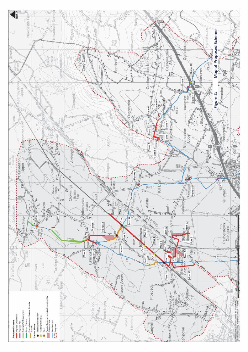
The scheme layout that will be submitted for planning consent is shown overleaf in Figure 2.
Morell River
Flood M
anagem
ent Schem
e
Non‐Technical Summary
5
Figure 2:
Map
of Proposed Scheme

Morell River Flood Management Scheme
EIA Report Non‐Technical Summary 6
2 PROJECT DESCRIPTION
The Morell River Flood Management Scheme involves the construction of approximately 7,423 metres of new flood embankments and approximately 474 metres of flood walls in the catchment of the Morell River and its tributaries the Slane, Kill and Painestown rivers.
The scheme also involves structural examination and potential remediation of up to 1,842 metres of existing embankments along the Morell, Painestown and Slane Rivers. Figure 2 on the previous page shows the locations of the proposed works.
The scheme also includes alteration works at several existing culverts. One culvert (C22), beneath the N7 which is currently throttled to reduce flow, will have its throttle opened to increase flows. Two culverts which cross beneath the Dublin‐Cork railway line (C4, C4a) will be throttled to reduce flows.
Two culverts have been identified as requiring in‐stream works for the installation of scour protection measures (C5 & C10). One culvert (C9), is in a poor state of repair and will require remediation. A further five culverts (C1, C2, C7, C18 & C19) will have tie‐ins with embankments. These culverts will be structurally assessed at the detailed design stage to determine if they require scour protection measures or underpinning.
In order to accommodate seasonal constraints, including the requirement for low river flows for instream works and spawning/migration periods for aquatic species, the project is expected to be constructed predominantly during summer months and will thus take place in phases over a total period of up to four years.
The construction works will commence at the confluence of the Rivers Morell and Liffey and from there the works will progress upstream, subject to the availability of suitable construction material. Within the works, the main artery of the scheme will be prioritised from embankments and associated tie‐ins and culverts.
The scheme will require approximately 61 weeks of construction in total, however the nature of the works dictate that they should be undertaken in settled weather, without flood risk. As such, it is hoped that the construction of the scheme will be completed within three years; however it may require up to four years, particularly if adverse/extreme weather conditions are encountered for prolonged periods of any particular year.
The “best case” scenario, based on completing all works within three years, considers the following phases:
Group One: The section from the confluence of the River Morell/River Liffey to Killeenmore (Morr 1 to 3 and Paines 1 to 3) which should be completed as a single phase.
Group Two: The second group consists of the embankments, walls, culverts and stream diversions from Morr 4 to 23 and may be divided across two years, depending on construction delivery time. If this is the case, Morr 4 to Morr 19 would most likely be completed as phase 2A in year one and Morr 20 to 23 as phase 2B in year two.
Group Three: encompasses Paines 4 & 5, Kill 1 and Slane 1 to 11.

Morell River Flood Management Scheme
EIA Report Non‐Technical Summary 7
3 ENVIRONMENTAL IMPACT ASSESSMENT
3.1 EIA SCREENING
The Planning and Development Regulations 2001 Schedule 5 Part II, Item 10 (f) (ii) (as amended by Article 19 (e) of the Planning and Development (Amendment) (2) Regulations 2011) state that an Environmental Impact Assessment (EIA) is required for infrastructure projects if the project meets the following criteria:
“Canalisation and flood relief works, where the immediate contributing sub‐catchment of the proposed works (i.e. the difference between the contributing catchments at the upper and lower extent of the works) would exceed 100 hectares or where more than 2 hectares of woodland would be affected or where the length of river channel on which works are proposed would be greater than 2 kilometres”.
The length of channel between the upper extent of the works (culvert at the N7) and the lower extent of the works (Horse Factory Bridge) is 8.6 kilometres. The contributing catchment in relation to this stretch of channel is 40 km2 in area (including the tributaries).
EIA Screening was undertaken by RPS in 2014 and it was determined that in line with the aforementioned criteria that the proposed scheme for the Morell catchment exceeded the thresholds in relation to flood relief works and therefore, an EIA would be required in relation to the proposed scheme.
3.2 EIA SCOPING
The EIA process is a method of ensuring that the likely effects on the environment of a new development, such as this, are fully understood and taken into account before planning permission is given for the development to proceed. Its primary purpose is to improve the quality of decision making by identifying potential environmental issues early in the project process.
Prior to work commencing on an EIA, it is important that the scope is effectively defined. A scoping exercise was carried out at the outset of this project to determine the issues that needed to be addressed in the EIAR. The scoping exercise involved the following main elements:
Preliminary site visits to assess the likely environmental impacts at first hand, Consultation with the principal statutory and non‐statutory consultees, Public consultation sessions through Public and Community Consultation process, A desktop study where information about the strategic study area from a number of sources
was examined.
Once the key issues were identified through this process, baseline studies/surveys were carried out. These enabled the prediction of the likely environmental impacts arising from the proposed development. These impacts were then evaluated in terms of their significance and their nature and magnitude.
A fundamental aim of the environmental assessment, as part of the design process, is to ensure that any potentially damaging effects are avoided or minimised and that the beneficial aspects of the project are enhanced. The most satisfactory means of impact mitigation is to avoid it at the source
Morell River Flood Management Scheme
EIA Report Non‐Technical Summary 8
either by site selection or as in this case, where possible, by redesign. Reduction involves lessening the degree of an impact which cannot be entirely avoided. Reduction acknowledges that some degree of adverse impact will arise, but provides means by which the conditions can be improved or compensated for.
3.3 ENVIRONMENTAL IMPACT ASSESSMENT REPORT
The general headings of the topics and issues reported on in the EIAR are as follows:
Population and Human Health
Traffic, Transport and Built Services
Air Quality and Climate
Noise and Vibration
Landscape and Visual Impact
Biodiversity ‐ Terrestrial
Biodiversity ‐ Aquatic
Hydrology and Drainage
Soils, Geology and Hydrogeology
Cultural Heritage
3.3.1 Population and Human Health
The key desired outcome of the proposed scheme is to protect human beings and their activities from adverse impacts to their property associated with flood events. The potential impacts associated with the construction and operation of the scheme were evaluated in this chapter, particularly in light of the location of the works adjacent to residential and agricultural properties.
3.3.1.1 Economic Activity
The assessment found that there is potential for some disruption to economic activity during the construction phase of the flood management scheme. Some temporary disruption to existing businesses may arise during construction, particularly where construction works will occur close to premises and also from indirect effects such as road restrictions and traffic management in works areas. The effects of the construction will occur for a temporary period only and no significant negative impacts such as job losses due to the construction phase are likely. A number of construction workers may move into the area on a temporary basis for the duration of the construction phase, which could support existing employment through local spending generated by construction workers e.g. on fuel, food, building supplies, haulage services, etc.
The implementation of a Construction Environmental Management Plan (CEMP) and Construction Traffic Management Plan (CTMP) is recommended as mitigation. Provided these are in place, impacts will be minimised to slight to moderate negative impacts, short‐term in the context of the resident community at large and temporary for individual properties. These will be unavoidable given the nature of the works required and should be considered in the context of the positive operation impacts.
Once operational, the proposed scheme will result in a significant long term positive impact to residents, commuters and businesses on a regional scale, by significantly reducing the flood risk to the N7 at Junction 6 and on a local scale by removing the flood risk to 30 residential properties and the local road network for a 1% AEP event.

Morell River Flood Management Scheme
EIA Report Non‐Technical Summary 9
3.3.1.2 Tourism and Leisure
The potential impacts of the scheme were also examined in respect of the local tourism and leisure resources. The N7 provides access from the greater Dublin area to a number of local tourism attractions and there are several golf courses located within the study area. The Morell catchment is important salmon and trout resource and the River Liffey has a number of active angling clubs.
As with 3.4.1 above, adverse impacts are primarily anticipated during the construction phase and will be largely mitigated through the implementation of the CEMP and CTMP as described above. Phasing of works around peak user times of other uses such as specific sports facilities, in particular Killeen Golf Club, and seasonal tourist facilities should be considered and regular updates and consultation with any sports clubs affected by construction works will be required.
Local angling clubs and IFI have been included in the consultation process and will be kept informed throughout the construction process. The potential for adverse impacts on fisheries was identified and mitigation and control measures have been proposed to reduce the potential impact to water quality from suspended sediments associated with construction activities. These will include the adoption of good work practices and sound design principles in the development of the scheme.
Once operational, the scheme will result in a significant long term positive impact on a regional scale, by significantly reducing the flood risk to the N7 at Junction 6 and on a local scale by removing the flood risk to local roads within the study area. The clubhouse at Killeen Golf Club will be protected for the 1% AEP event and there are no predicted operational phase impacts in respect of fisheries/angling, provided that mitigation measures in respect of aquatic ecology and water quality are implemented for maintenance.
3.3.1.3 Land Use
The majority of the proposed flood management scheme will be constructed on agricultural land and the GIS set up for landowner identification and liaison has identified 140 agricultural properties potentially affected by the proposed scheme. 31 non‐agricultural properties are also potentially affected.
Potential impacts to land use were examined in the chapter. In addition to impacts from noise, dust and traffic which are addressed separately in their respective chapters, the potential issues include disturbance to livestock, severance, disturbance to field water supplies and biosecurity concerns.
General access to some land uses will suffer some unavoidable localised slight temporary negative impacts during construction. Extensive landowner consultation has been carried out during the development of the proposed scheme and a stakeholder database has been developed to record the particular mitigation requirements for individual land parcels. Consultation with landowners will continue throughout detailed design and construction of the scheme to ensure that appropriate mitigation for individual landowners is agreed between the landowner and the Contractor and will be implemented. All lands temporarily acquired for construction will be re‐instated to pre‐construction conditions and no residual impacts on agriculture and land use are anticipated from construction activity.
During the operational phase, significant areas of land and a wide range of land uses such as residential and agricultural will benefit from reduced flood risk, though some agricultural areas will be included in the post scheme floodplain. There are no mitigation measures to off‐set significantly

Morell River Flood Management Scheme
EIA Report Non‐Technical Summary 10
reduced land usage due to new embankment and wall locations. Landowners have been consulted with extensively in the development of the scheme design and for those affected landowners; an appropriate accommodation works compensation package will be agreed. There are also no mitigation measures to off‐set those areas that will experience significantly increased flooding due to the proposed scheme. However, adversely affected landowners have been accommodated either through an appropriate accommodation works compensation package or by protecting adjacent land parcels, where possible without being detrimental to the scheme. The overriding benefits to the area are considered to outweigh any localised negative impacts.
3.3.1.4 Other Aspects
In addition to Economic Activity, Tourism and Leisure and Land use, the chapter also examined the potential impacts to the resident and working population in terms of Education, Health, Safety, Population Demographics and Employment. The assessment found that, as with sections 3.3.1.1 to 3.3.1.3 above, while people living and working in the area have the potential to experience temporary adverse impacts during construction, the construction phase of the proposed scheme does not have the potential to impact on population levels or the profile of the local population. Construction traffic and construction works along the roadside and the resultant temporary traffic management procedures may result in some minor disruption to local traffic which may include increases to typical journey times to schools and health care facilities. Temporary construction noise, vibration and air quality levels have been assessed as being below the thresholds where health may be affected. Potential impacts on drinking water quality were identified and will be addressed through the adoption of good construction site practices, water quality monitoring and the implementation of an accidental spillage pollution prevention plan. These impacts will be mitigated via the CEMP, CTMP and effective information dissemination throughout the construction phase.
In terms of the operation phase, the scheme will present a significant long term positive impact, as it will result in a reduction in the flood plain and local roads will remain accessible during a 1%AEP event. This may encourage more residents and businesses to move into the Study Area.
3.3.2 Traffic, Transport and Infrastructure
3.3.2.1 Traffic and Transport
The potential impacts from the construction and operation of the Morell River FMS on traffic and transportation infrastructure have been assessed.
A significant proportion of the proposed scheme works will be focused in close proximity to the R406, L2010, L6021 and Killeenmore Road. A cordon area was therefore identified, to highlight the area of works in relation to the surrounding road network. Automatic Traffic Count (ATC) traffic surveys were carried out on the principal routes leading to the cordon area to quantify the existing traffic on the routes and inform the impact assessment.
During the construction phase, there will be an average of 40 HGV deliveries per day bringing the required construction materials to the embankment or flood wall under construction. An average day, therefore, would consist of approximately 5 deliveries per hour over the 8 hour working day. This equates to a total of 80 two‐way HGV movements (40 inbound and 40 outbound) per day. Although an average of 40 HGV deliveries is anticipated, a maximum of 60 HGV deliveries will be proposed in any single day.

Morell River Flood Management Scheme
EIA Report Non‐Technical Summary 11
A desktop and on‐site observation study was also undertaken to determine the most suitable sites for potential stockpiling of material during the construction phases. Three stockpiling locations were identified and these are shown in Figure 1.
Evaluation of the ATC survey results showed that the overall impact of the construction traffic on the surrounding national and regional road network, in terms of absolute traffic volumes, is minimal. In order to mitigate against potential impacts on the local roads leading to the various works areas, it is proposed that a Construction Traffic Management Plan (CTMP) will be prepared in advance of the proposed works to minimise any impacts on other road users and to maximise road safety along the haul routes.
The aim of a CTMP is to put in place procedures to manage construction traffic effectively. The plan will consider construction traffic accessing the site via the public road network as well as traffic circulation within the construction site. It should also outline measures to enhance the efficient transportation of construction materials and machinery whilst minimising delay and disruption to the general traffic. In addition to addressing general traffic management issues such as signage, temporary traffic controls, temporary speed limits, etc. the CTMP will also include provisions such as public information strategies, maintenance of road cleanliness, monitoring for and repairing any damage caused by construction traffic and ensuring adequate emergency response systems are in place.
The traffic management mechanisms described above will ensure that the works will be co‐ordinated and controlled. The detailed CTMP will be developed by the Contractor and agreed with the Local Authority, TII and any other relevant stakeholders post consent. Once the mitigation measures are implemented, the HGV movements associated with the construction phase are not predicted to cause a significant residual impact on the surrounding road network. Only minor traffic requirements will be associated with maintenance requirements for the operational phase. Therefore, there are no predicted residual impacts for the operational phase of the development.
3.3.2.2 Built Services
High‐level identification of above and below ground utilities within the proposed works areas has taken place. Gas Networks Ireland infrastructure exists within the vicinity of Straffan, Kill and Palmerstown Demesne but does not extend into or close to the proposed works areas. An Aurora Telecom fibre‐optic cable was identified as being located in the vicinity of the Morr 20 works.
Water supply and water sewerage pipes also exist within the area of the proposed scheme, but are largely confined to the road network. Overhead telecommunication cables are also found alongside local roads. It is not expected that works will require interference with these services.
In terms of electricity infrastructure, High Voltage 110/220kv cables cross four of the scheme’s measures (Morr 4, Morr 9, Paines 2 and Paines 3. MV 10kv/20kv cables cross or are in immediate proximity to 12 of the proposed measures and two of the possible stockpiling/site compound areas. LV 230v/400v cables cross four of the proposed measures.
Maps of all the above services are available to the design and construction teams. Good design, incorporating appropriate precautionary measures agreed at detailed design stages and the implementation of appropriate site management measures during the construction phase will reduce disturbances to utilities. Precautions will be necessary during construction of the works in order to
Morell River Flood Management Scheme
EIA Report Non‐Technical Summary 12
ensure there is no damage to any of this infrastructure. These precautions will be determined at detailed design stage in consultation with the Service Providers.
3.3.3 Air Quality
The Air Quality & Climate chapter has assessed the existing air quality situation in the vicinity of the proposed development and examined the potential impacts the proposed scheme may have during both the construction and operational phases. The assessment also proposes mitigation measures to help ameliorate any potential increases in air pollutants (particularly dust) during the construction phase and also suggests a number of good practice measures to reduce energy consumption and minimise CO2.emissions.
The air quality impact assessment concluded the additional vehicular traffic on the R406, R407, L2010 and L2011 is not predicted to increase the concentrations of air quality parameters to any great extent. The overall impact of the construction traffic on the surrounding national and regional road network, in terms of absolute traffic volumes, is minimal and will result in a negligible impact on air quality.
The potential for dust to be emitted depends on the type of construction activity being carried out in conjunction with environmental factors including levels of rainfall, wind speeds and wind direction. The potential for impact from dust depends on the distance to potentially sensitive receptors’ locations and whether the wind can carry the dust to these locations.
In order to mitigate construction dust emissions during the construction phase, a dust minimisation plan will be prepared as part of the Construction Environmental Management Plan (CEMP). The implementation of a dust minimisation plan during the construction phase of the project will include, but is not limited to, measures such as:
Site roads and public roads outside the site shall be regularly inspected and cleaned as necessary;
Any site roads with the potential to give rise to dust will be regularly watered;
Vehicles leaving the site shall use [self‐contained] wheel wash facilities;
Material handling and stockpiling shall be designed and laid out to minimise exposure to wind;
Water misting or sprays shall be used as required during dry or windy periods;
Vehicles delivering material with dust potential shall be enclosed or covered with tarpaulin plus those which present a risk of spillage of materials will be loaded in a way that prevents spillage;
All vehicles will be kept suitably maintained by the contractor to ensure that emissions of engine generated pollutants is kept to a minimum; and
Regular inspections will be carried out by the construction contractor to monitor the potential for dust deposition and for longer periods of works monthly dust monitoring may be carried out.
If the construction contractor adheres to good working practices and dust mitigation measures the levels of dust generated are assessed to be minimal and are unlikely to cause an environmental nuisance. In respect of climate, no significant impacts are predicted in the assessment, however mitigation measures to minimise CO2 emissions from HGVs and transport will be addressed via the CTMP (see above) and also by the adoption of good site practice, e.g. turning off vehicle engines when not in use for more than five minutes. The air quality chapter also recommends the implementation of an Energy Management System to minimise energy consumption within the site compound buildings.
Morell River Flood Management Scheme
EIA Report Non‐Technical Summary 13
Once operational, the proposed scheme is not expected to generate any impacts to air quality/climate.
3.3.4 Noise
A noise and vibration impact assessment was undertaken to evaluate the potential for adverse impacts associated with the proposed scheme. The assessment covered both construction and operational phases of the proposed scheme.
The most noticeable noise impact will occur during the general the construction activities associated with the proposed scheme. There are a number of noise sensitive receptors located adjacent to the proposed work areas where embankments and new flood walls will be constructed.
Noise predictions during construction were undertaken for the various receptors in accordance with BS 5228‐1: 2009: Code of Practice for Noise and Vibration Control on Construction and Open Sites: Noise to predict noise levels at nearby noise sensitive receptors. The results of the assessment indicated that predicted construction noise levels at varying distances from the proposed works areas for all identified receptors would in all cases be below the NRA Guidelines’ maximum permissible noise level of 70 dB LAeq,1hour for Monday – Friday (07:00 – 19:00 hrs).
An assessment of the predicted noise impacts from increased road traffic was undertaken in accordance with the UK’s Highways Agency ‘Design Manual for Roads and Bridges’ HD 213/11 Volume 11, Section 3, Part 7 Revision 1. The predicted change in noise level due to additional vehicular traffic on the assessed roads (those assessed for % increase impacts in the Traffic chapter, see 3.5 above) for the construction phase are less than 1dB and would therefore be imperceptible.
On local roads there is some potential for temporary increases in vehicle noise as HGV deliveries of materials are made to the local works areas. Mitigation has been proposed, primarily through the implementation of the CEMP, which will include measures to minimise disturbance by noise during construction including erecting temporary screens or hoarding in locations where residential properties are in close proximity to construction works. The proposed hours of construction 07:30‐16:30 Monday‐Friday will also help to mitigate against noise nuisance.
In respect of vibration, the assessment concluded that the levels of vibration generated by construction activities are anticipated to be below the criteria specified in the standards BS6472‐1: 2008. However, it is nonetheless proposed that precondition surveys and vibration monitoring will be carried out for all properties in close proximity to construction works and haul routes. Survey and monitoring locations will be identified during detailed design and agreed with residents/owners as part of the CEMP in advance of the construction works.
A communications procedure between the public, the Contractor and Kildare County Council will be implemented for construction noise and vibration related issues.
Once operational, the proposed scheme does not incorporate any anticipated noise or vibration sources and therefore no residual impacts are predicted.

Morell River Flood Management Scheme
EIA Report Non‐Technical Summary 14
3.3.5 Landscape & Visual
The proposed scheme is located directly within the River Morell Lowland Landscape Character Area. The key potential direct impact on this landscape is from construction traffic movements through the lowland landscape, the physical works of the flood walls and embankments and the loss of any vegetation. The impact assessment also considered the impacts of the temporary use of the proposed potential stockpiling/site compound areas.
The landscape assessment has indicated that the increase in construction traffic travelling to and from the construction sites will blend with the existing use along the local road network without significant change in landscape resource. The construction of embankments and flood walls will require construction equipment that will be noticeable while in operation, but such activities will be localised in their effect, as the lowland landscape quickly absorbs features that are not particularly tall.
The assessment evaluated that the construction of the proposed scheme will not significantly affect any sensitive landscape areas, scenic routes, or protected views. The areas for material stockpiling are generally well screened by field boundary vegetation, which will be retained, with current agricultural usage being returned following construction of the scheme.
The landscape and visual impact assessment chapter has included a number of mitigation measures to reduce the potential impact of the proposed scheme. These include: choosing materials for flood wall construction that fit in with the surrounding area and using stone cladding in areas visible from the roadside, planting embankments with grass, protecting existing trees, materials stockpiles being limited to a maximum height of 1m, and having fencing around site offices painted green to integrate with surrounding landscape. Site compounds will employ the minimum lighting necessary for safety and lighting shall be directed into the compound and away from adjacent residential properties.
The assessment found that the construction works will result in some adverse residual landscape and visual impacts, where vegetation removal is required for wall and embankment construction and particularly where flood walls are required in close proximity to properties. During operation these impacts would be reduced as landscaping and replanting of vegetation around the new measures matures. Overall the residual impacts were assessed to be minor negative and not significant
3.3.6 Biodiversity ‐ Terrestrial
An Ecological Impact Assessment (EcIA) was carried out to identify, quantify and evaluate the potential effects of the project on ecological features. A desktop study was carried out and habitat field surveys undertaken in 2014, 2015 and 2017. The presence of any invasive species within proposed works areas was noted and the site walkovers included an assessment of the presence, or likely presence, of rare or protected fauna and bird species.
The surveys identified a range of habitats including depositing/lowland rivers, wet grassland, marsh, riparian woodland, mixed broadleaved woodland, mixed conifer woodland, scrub, hedgerows and treelines. The invasive species Giant Rhubarb (Gunnera tinctoria) was observed in several locations along the Slane River at Tuckmilltown.
A number of mammal burrows were recorded throughout the proposed scheme area which could potentially be used by badger, due to size and shape, although they did not appear active at the time of survey and there was no evidence of badger usage. Mammal trails were also observed throughout

Morell River Flood Management Scheme
EIA Report Non‐Technical Summary 15
the study area, potentially badger, however could also be as a result of rabbit, fox or otter. A number of trees and treelines were identified as having low to moderate bat roost potential. Bat species are likely to utilise the Morell, Painestown, Slane and Kill Rivers, other smaller streams/watercourses, the Grand Canal, hedgerows and treelines as commuting corridors.
A variety of bird species were observed however no red listed or Annex I bird species were recorded during the surveys. The Grand Canal pNHA bisects the study area but it has no direct connectivity with any of the proposed works. Other pNHAs are located downstream of the catchment and thus are hydraulically linked. The potential for indirect impacts to these pNHAs will be mitigated through adoption of effective water quality/aquatic ecology protection measures, see section 3.10 below.
An Appropriate Assessment screening has been carried out in accordance with the European Communities (Birds and Natural Habitats) Regulations 2011 (as amended), to determine the potential for likely significant effects on nearby European sites as a result of the proposed scheme. The Appropriate Assessment Screening Report concluded that there is no likelihood of significant effects on any European Sites arising from the FMS, either alone or in combination with other plans or projects.
Potential impacts from construction activities and site clearance include direct loss of habitats and disturbance through trampling or damage by machinery. There will be a permanent loss of habitat in the footprint of any new flood alleviation measures or if vegetation removal is required for site compounds or access tracks. Although impacts arising from disturbance to habitats would last longer than the construction period, they are likely to be reversible in time once construction ceases allowing the habitat to re‐establish in the vicinity of the proposed scheme.
The impact assessment has recommended a number of mitigation measures. Of key importance will be to minimise, where possible, the removal of existing vegetation. This will be carried out in the first instance during the detailed design through avoidance, where possible, of riparian woodland and mature vegetated areas. During construction, at each site, the proposed works area will be clearly marked out with temporary fencing or a suitable alternative method to ensure that plant and vehicles remain within the working area and do not extend the site footprint unnecessarily. Where possible, vegetation will be reinstated following completion of the scheme, in particular features such as hedgerows and trees which should be replaced using native hedgerow or tree species.
Prior to undertaking any works along the scheme measures or setting up central base compounds, the Contractor shall engage a suitably qualified ecologist or surveyor to carry out surveys for badger, otter, bat roosts and invasive plant species. Surveys will also be carried out for nesting birds, if vegetation removal/trimming is required during the bird nesting season (1st March to 31st August inclusive). Should the surveys discover protected species or invasive plant species, then appropriate mitigation measures will be applied in accordance with national guidelines and legislation under the supervision of qualified personnel. Biosecurity measures including equipment cleaning will be employed by the Contractor to prevent the spread of invasive species.
While the operational requirements of the proposed scheme in respect of maintenance will be monitored and reviewed on an annual basis, it is envisaged that maintenance works would only be undertaken as and when required, e.g. on a six to ten year cycle. Maintenance works will be subject to the relevant environmental assessment requirements, including Screening for Appropriate Assessment, to consider the environmental sensitivities around the maintenance required, and will be required to be carried out in line with current best practice at the time of maintenance.
Morell River Flood Management Scheme
EIA Report Non‐Technical Summary 16
It was concluded that, provided that the mitigation measures included within the EIAR are implemented in full, then it is not anticipated that there will be any residual significant negative impacts on terrestrial habitats, flora or fauna as a result of the proposed scheme.
3.3.7 Biodiversity ‐ Aquatic
The proposed scheme was assessed in respect of its potential impacts on the aquatic environment. The approach adopted in the assessment used desk‐based and field‐collected data to describe baseline fisheries and aquatic ecology conditions at twelve stations along the rivers within the study area, on or adjacent to which the proposed scheme would be constructed. It also considered the potential risks of the scheme’s construction in locations where instream works might be required in watercourses that are considered to be of moderate or high sensitivity for fisheries and aquatic ecology.
The assessment considered the potential significance of the effects associated with the construction of the embankments, flood walls, stream diversions and culvert alterations, along with the temporary construction compounds, haul routes, watercourse crossings and stockpiles.
The main source of risk for potential impacts on fish and aquatic ecology is during the construction phase. The identified risks include potential impacts of sediment release and entrainment which can give rise to increased bottom sedimentation, which, in turn, can adversely impact macroinvertebrates and aquatic habitat quality. Elevated suspended solids levels within the water column can damage the gills of salmonid fish, white‐clawed crayfish and benthic macroinvertebrates and can smother fish spawning areas when deposited. Activities which present risk of sediment loss include excavation and backfilling, soil and vegetation clearance, bank disturbance caused by plant equipment, run‐off from materials stockpiles, water over‐pumping and discharge of sediment laden water back to the watercourse, installation of temporary crossing structures and movement of plant machinery, removal of flumes/ dams/ crossing culverts and during reinstatement of bank soils and vegetation.
Other potential impacts include the removal of riparian vegetation, obstruction of fish passage and release of other pollutants, such as hydrocarbon spills and cement or concrete wash off.
Field surveys were also carried out for signs of otter presence. These surveys found that otters do commute, forage and possibly breed along the watercourses in the Morell system and evidence of activity was found the vicinity of some of the proposed scheme measures.
A range of mitigation measures has been developed for the proposed construction activities. These include locating stockpiles and construction compounds away from vulnerable watercourses, as well as the avoidance of carrying out works during periods of flood risk. Works areas should incorporate effective measures to manage runoff and silt, such as using sediment barriers, geotextiles, interception ditches, silt traps and collection and treatment of silty water. An over‐arching mitigation measure will be for the contractor to draw up a CEMP that incorporates detailed mitigation measures in relation to the implementation of all measures proposed. Each of the measures will have its own Method Statement prepared which will be strictly adhered to by staff and contractors involved in the works and which will be overseen by the Contractor’s site representative/foreman.
Instream works will be carried out ‘in the dry’ and no instream or potentially significantly damaging out of river works should occur during restricted periods for relevant species, which include Salmon,

Morell River Flood Management Scheme
EIA Report Non‐Technical Summary 17
Brook, River Lamprey, Sea Lamprey, White Clawed Crayfish and Trout. As discussed above, a detailed Method Statement will be drawn up by the contractor, indicating what measures will be taken to avoid sediment or soil loss associated with all aspects of the construction and how these will be monitored for effectiveness. Method Statements for instream works will be subject to review and approval by IFI and the NPWS prior to construction.
The proposed stream diversions will be designed to incorporate natural habitat characteristics and the use of natural bed materials. Fish and crayfish will need to be removed from the impacted section of the existing channel in advance; this will be carried out by authorised personnel in agreement with IFI. The design of any culvert alterations and instream works (including scour protection) will adopt current best practice recommendations to provide appropriate hydraulic and morphological characteristics fulfilling the requirements of salmonid habitats as advised by IFI. The Contractor will also adopt best practice in the storage and use of fuels, oils, chemicals and cement or concrete to minimise the risk of spillage. A mechanism for reporting of pollution incidents will be agreed in advance between the Contractor, the IFI and the other relevant authorities including Kildare County Council.
Site specific avoidance and mitigation measures have been identified in the assessment in respect of the identified Otter habitat. Pre‐construction surveys for otter will be carried out and the OPW has Environmental Management Protocols and Standard Operating Procedures (SOPs) for Otter which will be followed.
During the operational phase, maintenance works will be subject to the relevant environmental assessment requirements, including Screening for Appropriate Assessment, to consider the environmental sensitivities around the maintenance required, and will be required to be carried out in line with current best practice at the time of maintenance.
Following the full implementation of the proposed mitigation measures included in the assessment it is anticipated that there will be Temporary Slight Negative residual impacts on the aquatic ecology of the Morell Catchment within the proposed scheme catchment as a result of construction works. It is expected that watercourses should recover after a short period and return to similar pre‐construction state.
3.3.8 Hydrology and Drainage
At present, up to 30 residential properties are at risk during the 1%AEP flood event. This chapter of the EIAR describes the hydraulic modelling that has taken place to develop the flood management scheme and the changes to the flood plain that will result from the implementation of the scheme.
During construction, the potential impacts to hydrology include blockage of river flows due to collapsing of unstable river banks or stockpiles and flooding of adjacent lands and properties caused by reduction of channel conveyancing capacity during construction. In addition, the pattern of runoff could change which may lead to drains and ditches receiving significantly more or less flow than they receive currently. Once the scheme is constructed, land used for temporary works will be restored to its original condition.
Mitigation is proposed in respect of drainage during construction and once the scheme is operational. Toe drains will be included at the base of the embankments, where required, in order to ensure that adjacent fields can continue to drain. Existing field drains that intersect the proposed
Morell River Flood Management Scheme
EIA Report Non‐Technical Summary 18
embankments will be dealt with, by diverting them to adjacent field drains or by maintaining a limited flow path through the proposed defence.
Once constructed, the scheme will lead to significant decrease in the overall 1% AEP flood extent and the affected properties and roads within the study area will be protected from flooding. However some localised land parcels which are mainly on agricultural land will be used to store flood waters and as such will experience increased flood levels for higher return period events. Consultation with affected landowners has taken place. As discussed above in section 3.3.1.4, the affected landowners have been accommodated either through an appropriate accommodation works compensation package or by protecting adjacent land parcels, where possible without being detrimental to the scheme.
3.3.9 Soils, Geology and Hydrogeology
The potential impact of the proposed scheme on the geological environment in relation to soil profiles, soil quality, the potential for slope stability issues and potential impacts to groundwater was examined.
Soil and sub‐soil will be excavated during construction activities including the clearing of ground and the construction of embankments and walls along the river. The excavated material will be reused for side‐slope protection and topsoil for the embankments and for regrading adjacent to the new walls. Potential impacts on soils and groundwater include the risk of spillage and contamination of watercourses and soils from the mixing of concreate material for the foundations and walls, as well as over‐compaction of soil and subsoil due to plant activities. Construction activity has the potential to cause sediment run‐off to adjacent watercourses and careful management is needed to avoid this.
Extensive ground investigations carried out to inform the scheme’s design have identified a number of areas where made ground is present. No evidence of contamination was observed during any of the ground investigations; however contingency measures have been included within the EIAR to address potential impacts, should any evidence of contamination be discovered during further site investigations or construction.
Waste Acceptance Criteria (WAC) analysis will be carried out on any made ground that is required to be excavated. Excavated made ground which is found to be unsuitable for reuse onsite and/or which has evidence of contamination will be required to be classified as inert, non‐hazardous or hazardous for offsite disposal. An outline Waste Management Plan has also been included as an appendix to the EIAR which includes procedures for the excavation, handling, storage and disposal of potentially contaminated material in accordance with industry best practices and waste management regulations.
Mitigation measures to minimise impacts on soils, geology and hydrogeology include the construction of permanent cut‐off ditches on the land side of all embankments to direct overland flow away from the embankments, rigorous management of potential contaminants and run‐off in the working areas, careful management of stockpiled soils and approval from a geotechnical engineer on the detailed design of embankments and new river banks.
The assessment has concluded that there will be slight negative impacts on soils, geology and hydrogeology during the construction of the proposed scheme; however these will be short term in nature and not significant. During operation no significant impacts are predicted.

Morell River Flood Management Scheme
EIA Report Non‐Technical Summary 19
3.3.10 Cultural Heritage
An archaeological and architectural heritage impact assessment was carried out via a combination of desk based survey and fieldwork.
Ground disturbances, such as topsoil stripping and excavations for flood management measures and stream diversions, have the potential to have a direct and negative impact on previously unrecorded archaeological features or deposits that may survive beneath the current ground level with no surface expression. Other ground disturbances associated with the construction of embankments adjacent to a number of bridge structures may incur inadvertent damage from plant activities, or burying of portions of the structures.
Mitigation measures include full time archaeological monitoring for areas in the proposed scheme due for topsoil stripping, and wade surveys for areas where stream realignment will take place. If any archaeological features or deposits are identified, a suitably qualified archaeologist will discern the most appropriate manner to proceed under licence by the National Monuments Service/DoAHRRGA.
Any ground disturbances with impacts on architectural structures, will be avoided by taking due care during the construction phase, avoidance of using sensitive structures/bridges during the use of haulage, and also maintaining a sufficient buffer (minimum of 1m) between any embankments and bridges during construction. The proposed potential stockpiling area at Paines 1‐3 was identified as having high archaeological potential. If this location is required for temporary materials storage during construction, the contractor will avoid topsoil stripping and will instead stockpile fill material on top of a geotextile layer.
Provided the recommended mitigation is implemented, the assessment concluded that no residual impacts are anticipated upon the archaeological, architectural or cultural heritage resource by the proposed scheme.
4 CONCLUSIONS
The EIAR provides a comprehensive assessment of the potential impacts for all the component parts of the proposed scheme. It sets out proposed mitigation measures to neutralise or reduce their potential adverse impact to an acceptable level.
The EIAR has been produced by a team of specialists in each of their subjects, grouped into a comprehensive assessment as a result of a programme of close interaction within and between the environmental team and the engineering design team over a two year period.
The approach has resulted in a thorough understanding of the combined effects of the different impacts. Regular and invaluable consultation has been held with landowners, the local community, Kildare County Council, the OPW and other key stakeholders, which has enabled the identified Option to be developed into the most appropriate design.

rpsgroup.com/ireland