· Web viewBuilding on highly visible sites incorporate a high standard of industrial design and...
62
Table 7.2.3.1.3.1 Assessable development - Light industry sub-precinct Performance outcome Examples that achieve aspects of the Performance Outcome E Compliance Yes No See PO or NA Justification for compliance General criteria Light industry location PO1 The Light industry sub-precinct is located in accordance with a Neighbourhood development plan that reflects the urban structure concept shown indicatively on Figure 7.2.3.1 - Caboolture West structure plan. No example provided. Site cover PO2 Building site cover allows for adequate on-site provision of: a. car parking; b. vehicle access and manoeuvring; c. setbacks to boundaries; d. landscaped areas. No example provided. Building height PO3 The height of buildings reflect the individual character of the sub- E3 Building height do not to exceed that mapped on Neighbourhood MBRC Planning Scheme - Caboolture West local plan - Enterprise and employment precinct - Light industry sub precinct - Assessable - 3 July 2017 1
Transcript of · Web viewBuilding on highly visible sites incorporate a high standard of industrial design and...

Table 7.2.3.1.3.1 Assessable development - Light industry sub-precinct
Performance outcome Examples that achieve aspects of the Performance Outcome
E Compliance Yes No See PO or NA
Justification for compliance
General criteriaLight industry locationPO1The Light industry sub-precinct is located in accordance with a Neighbourhood development plan that reflects the urban structure concept shown indicatively on Figure 7.2.3.1 - Caboolture West structure plan.
No example provided.
Site coverPO2Building site cover allows for adequate on-site provision of:a. car parking;b. vehicle access and manoeuvring;c. setbacks to boundaries;d. landscaped areas.
No example provided.
Building heightPO3The height of buildings reflect the individual character of the sub-precinct.
E3Building height do not to exceed that mapped on Neighbourhood development plan.
Setbacks
MBRC Planning Scheme - Caboolture West local plan - Enterprise and employment precinct - Light industry sub precinct - Assessable - 3 July 2017 1
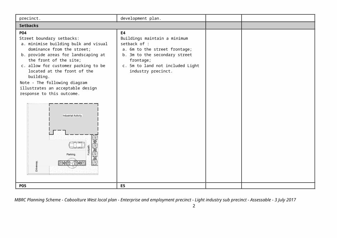
PO4Street boundary setbacks:a. minimise building bulk and visual dominance
from the street;b. provide areas for landscaping at the front of the
site;c. allow for customer parking to be located at the
front of the building.Note - The following diagram illustrates an acceptable design response to this outcome.
E4Buildings maintain a minimum setback of :a. 6m to the street frontage;b. 3m to the secondary street frontage;c. 5m to land not included Light industry
precinct.
PO5Side and rear boundary setbacks maintain views, privacy, access to natural light and the visual amenity of adjoining sensitive land uses.
E5Where a development adjoins the Urban living precinct, the building is setback a minimum of 3m from the property boundary and includes landscaping along the boundary appropriate for screening with a mature height of at least 3m.
MBRC Planning Scheme - Caboolture West local plan - Enterprise and employment precinct - Light industry sub precinct - Assessable - 3 July 2017 2

Note - Refer to Planning scheme policy - Integrated design for determining acceptable levels of landscaping for screening purposes.
Building appearance and designPO6Building on highly visible sites incorporate a high standard of industrial design and construction, which adds visual interest to the streetscape and reduces the perceived bulk of the building from the street. Note - The following example illustrates an acceptable design response to this outcome.
E6Where fronting a main street, or visible from a Park(57) or Neighbourhood hub lot, buildings provide a high level of architectural design, by incorporating: a. a range of building materials, colours
and features;b. facade articulation along street
frontages;c. design features to promote customer
entry points;d. materials that are not highly reflective.
MBRC Planning Scheme - Caboolture West local plan - Enterprise and employment precinct - Light industry sub precinct - Assessable - 3 July 2017 3

PO7Buildings on highly visible corner allotments:a. address both street frontages;b. contain building openings facing both street
frontages;c. do not present blank unarticulated walls to
either frontage.Note - The following example illustrates an acceptable design response to this outcome.
No example provided.
Staff recreation areaPO8Development provides an on-site recreation area for staff that:a. includes seating, tables and rubbish bins;b. is adequately protected from the weather;c. is safely accessible to all staff;d. is separate and private from public areas;e. is located away from a noisy or odorous activity.
No example provided.
LandscapingPO9 E9
MBRC Planning Scheme - Caboolture West local plan - Enterprise and employment precinct - Light industry sub precinct - Assessable - 3 July 2017 4
Landscaping is provided on the site to:a. visually soften the built form, areas of
hardstand, storage areas and mechanical plant associated with the on-site activities;
b. complement the existing or desired streetscape;c. minimise the impact of industrial development
on adjoining lots not zoned for industrial purposes.
Landscaping is provided and maintained in accordance with Planning scheme policy - Integrated design.
FencingPO10The provision of fencing on street frontages does not dominate the streetscape or create safety issues.Note - The following example illustrates an acceptable design response to this outcome.
E10Where fencing is provided on the street frontage, it has a minimum transparency of 70%.
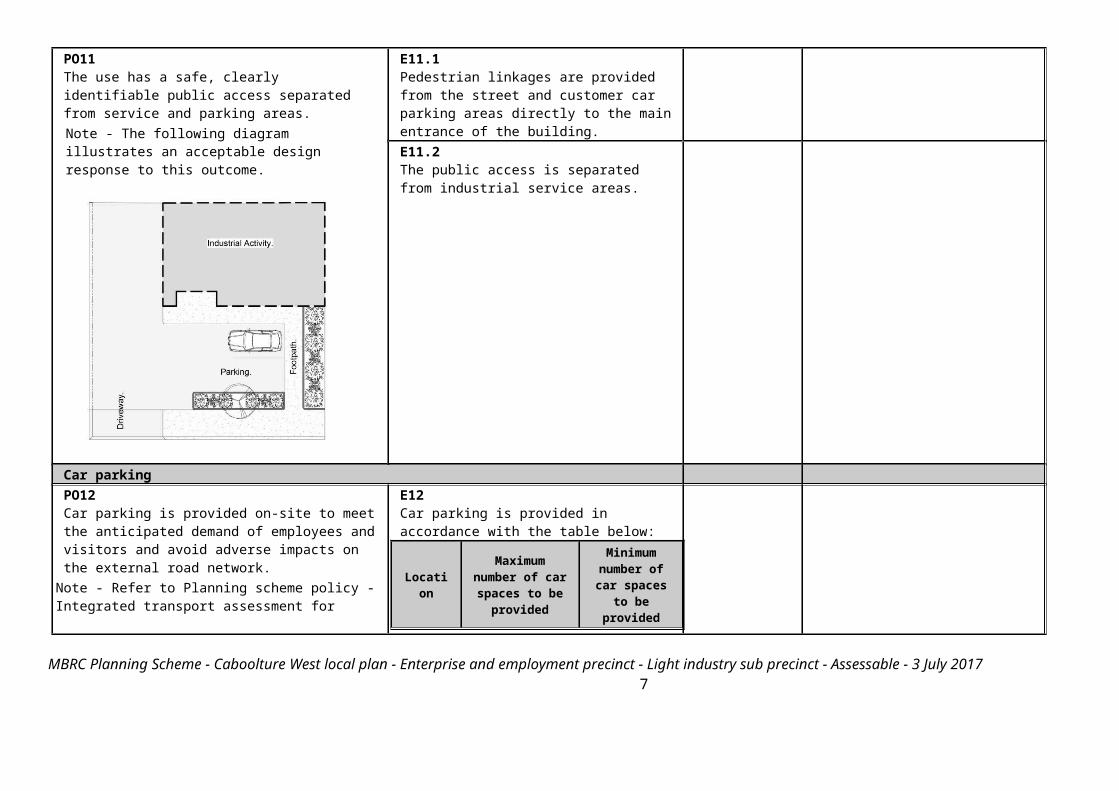
Public accessE11.1Pedestrian linkages are provided from the street and customer car parking areas directly to the main entrance of the building.
MBRC Planning Scheme - Caboolture West local plan - Enterprise and employment precinct - Light industry sub precinct - Assessable - 3 July 2017 5

PO11The use has a safe, clearly identifiable public access separated from service and parking areas.Note - The following diagram illustrates an acceptable design response to this outcome.
E11.2The public access is separated from industrial service areas.
Car parkingPO12Car parking is provided on-site to meet the anticipated demand of employees and visitors and avoid adverse impacts on the external road network.
Note - Refer to Planning scheme policy - Integrated transport assessment for guidance on how to achieve compliance with this outcome.
E12Car parking is provided in accordance with the table below:
Location
Maximum number of car spaces to be
provided
Minimum number of car spaces to be
providedWhere within 400m of a Local centre sub-precinct or
1 per 30m2 of GFA
1 per 50m2 of GFA
MBRC Planning Scheme - Caboolture West local plan - Enterprise and employment precinct - Light industry sub precinct - Assessable - 3 July 2017 6
Neighbourhood hub
All other areas Refer to Schedule 7 - Car parking.
PO13The design of car parking areas:a. does not impact on the safety of the external
road network;b. ensures the safety of pedestrians at all times;c. ensures the safe movement of vehicles within
the site.
E13All car parking areas are designed and constructed in accordance with Australian Standard AS2890.1.
Bicycle parking and end of trip facilitiesNote - Building work to which this code applies constitutes Major Development for purposes of development requirements for end of trip facilities prescribed in the Queensland Development Code MP 4.1. PO14a. End of trip facilities are provided for employees
or occupants, in the building or on-site within a reasonable walking distance, and include: i. adequate bicycle parking and storage
facilities; andii. adequate provision for securing
belongings; andiii. change rooms that include adequate
showers, sanitary compartments, wash basins and mirrors.
b. Notwithstanding a. there is no requirement to provide end of trip facilities if it would be unreasonable to provide these facilities having regard to: i. the projected population growth and
forward planning for road upgrading and development of cycle paths; or
ii. whether it would be practical to commute to and from the building on a bicycle, having regard to the likely commute distances and nature of the terrain; or
E14.1Minimum bicycle parking facilities are provided at a rate of 1 bicycle parking space for every 3 vehicles parking spaces required by Schedule 7 – Car parking. Editor's note - The examples for end of trip facilities prescribed under the Queensland Development Code permit a local planning instrument to prescribe facility levels higher than the default levels identified in those acceptable solutions. This example is a combination of the default levels set for end of trip facilities in the Queensland Development Code and the additional facilities required by Council. E14.2Bicycle parking is:a. provided in accordance with Austroads
(2008), Guide to Traffic Management - Part 11: Parking;
b. protected from the weather by its location or a dedicated roof structure;
c. located within the building or in a
MBRC Planning Scheme - Caboolture West local plan - Enterprise and employment precinct - Light industry sub precinct - Assessable - 3 July 2017 7

iii. the condition of the road and the nature and amount of traffic potentially affecting the safety of commuters.
Editor's note - The intent of b above is to ensure the requirements for bicycle parking and end of trip facilities are not applied in unreasonable circumstances. For example these requirements should not, and do not apply in the Rural zone or the Rural residential zone etc.
Editor's note - This performance outcome is the same as the Performance Requirement prescribed for end of trip facilities under the Queensland Development Code. For development incorporating building work, that Queensland Development Code performance requirement cannot be altered by a local planning instrument and has been reproduced here solely for information purposes. Council’s assessment in its building work concurrence agency role for end of trip facilities will be against the performance requirement in the Queensland Development Code. As it is subject to change at any time, applicants for development incorporating building work should ensure that proposals that do not comply with the examples under this heading meet the current performance requirement prescribed in the Queensland Development Code.
dedicated, secure structure for residents and staff;
d. adjacent to building entrances or in public areas for customers and visitors.
Note - Bicycle parking structures are to be constructed to the standards prescribed in AS2890.3.Note - Bicycle parking and end of trip facilities provided for residential and non-residential activities may be pooled, provided they are within 100 metres of the entrance to the building. Editor's note - The examples for end of trip facilities prescribed under the Queensland Development Code permit a local planning instrument to prescribe facility levels higher than the default levels identified in those acceptable solutions. This examples is an amalgamation of the default levels set for end of trip facilities in the Queensland Development Code and the additional facilities required by Council. E14.3For non-residential uses, storage lockers:a. are provide at a rate of 1.6 per bicycle
parking space (rounded up to the nearest whole number);
b. have minimum dimensions of 900mm (height) x 300mm (width) x 450mm (depth).
Note - Storage lockers may be pooled across multiple sites and activities when within 100 metres of the entrance to the building and within 50 metres of bicycle parking and storage facilities. Editor's note - The examples for end of trip facilities prescribed under the Queensland Development Code permit a local planning
MBRC Planning Scheme - Caboolture West local plan - Enterprise and employment precinct - Light industry sub precinct - Assessable - 3 July 2017 8

instrument to prescribe facility levels higher than the default levels identified in those acceptable solutions. This example is an amalgamation of the default levels set for end of trip facilities in the Queensland Development Code and the additional facilities required by Council. E14.4For non-residential uses, changing rooms:
a. are provided at a rate of 1 per 10 bicycle parking spaces;
b. are fitted with a lockable door or otherwise screened from public view;
c. are provided with shower(s), sanitary compartment(s) and wash basin(s) in accordance with the table below:
Bicycle spaces provided
Male/ Female
Change rooms required
Showers required
Sanitary compartments required
Washbasins required
1-5 Male and female
1 unisex change room
1 1 closet pan
1
6-19 Female
1 1 1 closet pan
1
20 or more
Male 1 1 1 closet pan
1
MBRC Planning Scheme - Caboolture West local plan - Enterprise and employment precinct - Light industry sub precinct - Assessable - 3 July 2017 9
Female
1 2, plus 1 for every 20 bicycle spaces provided thereafter
2 closet pans, plus 1 sanitary compartment for every 60 bicycle parking spaces provided thereafter
1, plus 1 for every 60 bicycle parking spaces provided thereafter
Male 1 2, plus 1 for every 20 bicycle spaces provided thereafter
1 urinal and 1 closet pans, plus 1 sanitary compartment at the rate of 1 closet pan or 1 urinal for every 60 bicycle space provided thereafter
1, plus 1 for every 60 bicycle parking spaces provided thereafter
Note - All showers have a minimum 3-star Water Efficiency Labelling and Standards (WELS) rating shower head.
Note - All sanitary compartments are constructed in compliance with F2.3 (e) and F2.5 of BCA (Volume 1).
d. are provided with: i. a mirror located above each wash
basin;ii. a hook and bench seating within each
shower compartment;iii. a socket-outlet located adjacent to
each wash basin.Note - Change rooms may be pooled across multiple sites, residential and non-residential
MBRC Planning Scheme - Caboolture West local plan - Enterprise and employment precinct - Light industry sub precinct - Assessable - 3 July 2017 10

activities when within 100 metres of the entrance to the building and within 50 metres of bicycle parking and storage facilities Editor's note - The examples for end of trip facilities prescribed under the Queensland Development Code permit a local planning instrument to prescribe facility levels higher than the default levels identified in those acceptable solutions. This example is an amalgamation of the default levels set for end of trip facilities in the Queensland Development Code and the additional facilities required by Council.
Loading and servicingPO15Service areas including loading/unloading facilities, plant areas and outdoor storage areas are screened from the direct view from public areas and non-Light industry sub-precinct land. Note - If landscaping is proposed for screening purposes, refer to Planning scheme policy - Integrated design for determining acceptable levels.
No example provided.
WastePO16Bins and bins storage areas are provided, designed and managed to prevent amenity impacts on the locality.
E16Bins and bin storage areas are provided, designed and managed in accordance with Planning scheme policy – Waste.
Environmental impactsPO17Where a use is not an environmentally relevant activity under the Environmental Protection Act, the release of any containment that may cause environmental harm is mitigated to an acceptable level.
E17Development achieves the standard listed in Schedule 1 Air Quality Objectives, Environmental Protection (Air) Policy 2008.
LightingPO18Lighting is directed and shielded to not cause unreasonable disturbance to any person on adjoining
E18Artificial lighting on-site is directed and shielded in such a manner as not to exceed
MBRC Planning Scheme - Caboolture West local plan - Enterprise and employment precinct - Light industry sub precinct - Assessable - 3 July 2017 11

land. the recommended maximum values of light technical parameters for the control of obtrusive light given in Table 2.1 of Australian Standard AS 4282 (1997) Control of Obtrusive Effects of Outdoor Lighting. Note - 'Curfewed hours' are taken to be those hours between 10pm and 7am on the following day.
Hazardous ChemicalsNote - To assist in demonstrating compliance with the following performance outcomes, a Hazard Assessment Report may be required to be prepared and submitted by a suitably qualified person in accordance with 'State Planning Policy Guideline - Guidance on development involving hazardous chemicals'.
Terms used in this section are defined in 'State Planning Policy Guideline - Guidance on development involving hazardous chemicals'. PO19Off sites risks from foreseeable hazard scenarios involving hazardous chemicals are commensurate with the sensitivity of the surrounding land use zones.
E19.1Off site impacts or risks from any foreseeable hazard scenario does not exceed the dangerous dose at the boundary of land zoned for vulnerable or sensitive land uses as described below: Dangerous Dosea. For any hazard scenario involving the
release of gases or vapours:i. AEGL2 (60minutes) or if not
available ERPG2;ii. An oxygen content in air <19.5% or
>23.5% at normal atmospheric pressure.
b. For any hazard scenario involving fire or explosion:i. 7kPa overpressure;ii. 4.7kW/m2 heat radiation.
If criteria E20.1 (a) or (b) cannot be achieved, then the risk of any foreseeable hazard scenario shall not exceed an individual fatality risk level of 0.5 x 10⁻⁶/year. E19.2Off site impacts or risks from any foreseeable hazard scenario does not exceed the
MBRC Planning Scheme - Caboolture West local plan - Enterprise and employment precinct - Light industry sub precinct - Assessable - 3 July 2017 12

dangerous dose at the boundary of a commercial or community activity land use zone as described below: Dangerous Dosea. For any hazard scenario involving the
release of gases or vapours:i. AEGL2 (60minutes) or if not
available ERPG2;ii. An oxygen content in air <19.5% or
>23.5% at normal atmospheric pressure.
b. For any hazard scenario involving fire or explosion:i. 7kPa overpressure;ii. 4.7kW/m2 heat radiation.
If criteria E20.2 (a) or (b) cannot be achieved, then the risk of any foreseeable hazard scenario shall not exceed an individual fatality risk level of 5 x 10⁻⁶/year. E19.3Off site impacts or risks from any foreseeable hazard scenario does not exceed the dangerous dose at the boundary of an industrial land use zone as described below: Dangerous Dosea. For any hazard scenario involving the
release of gases or vapours:i. AEGL2 (60minutes) or if not
available ERPG2;ii. An oxygen content in air <19.5% or
>23.5% at normal atmospheric pressure.
b. For any hazard scenario involving fire or explosion:i. 14kPa overpressure;ii. 12.6kW/m2 heat radiation.
If criteria E20.3 (a) or (b) cannot be achieved, then the risk of any foreseeable hazard scenario shall not exceed an individual fatality
MBRC Planning Scheme - Caboolture West local plan - Enterprise and employment precinct - Light industry sub precinct - Assessable - 3 July 2017 13

risk level of 50 x 10-6/year. PO20Buildings and package stores containing fire-risk hazardous chemicals are designed to detect the early stages of a fire situation and notify a designated person.
E20Buildings and package stores containing fire-risk hazardous chemicals are provided with 24 hour monitored fire detection system for early detection of a fire event.
PO21Common storage areas containing packages of flammable and toxic hazardous chemicals are designed with spill containment system(s) that are adequate to contain releases, including fire fighting media.
E21Storage areas containing packages of flammable and toxic hazardous chemicals are designed with spill containment system(s) capable of containing a minimum of the total aggregate capacity of all packages plus the maximum operating capacity of any fire protection system for the storage area(s) over a minimum of 60 minutes.
PO22Storage and handling areas, including manufacturing areas, containing hazardous chemicals in quantities greater than 2,500L or kg within a Local Government “flood hazard area” are located and designed in a manner to minimise the likelihood of inundation of flood waters from creeks, rivers, lakes or estuaries.
E22.1The base of any tank with a WC >2,500L or kg is higher than any relevant flood height level identified in an area’s flood hazard area. Alternatively: a. bulk tanks are anchored so they cannot
float if submerged or inundated by water; and
b. tank openings not provided with a liquid tight seal, i.e. an atmospheric vent, are extended above the relevant flood height level.
E22.2The lowest point of any storage area for packages >2,500L or kg is higher than any relevant flood height level identified in an area’s flood hazard area. Alternatively, package stores are provided with impervious bund walls or racking systems higher than the relevant flood height level.
NoisePO23Noise generating uses do not adversely affect
No example provided.
MBRC Planning Scheme - Caboolture West local plan - Enterprise and employment precinct - Light industry sub precinct - Assessable - 3 July 2017 14

existing or potential noise sensitive uses. Note - The use of walls, barriers or fences that are visible from or adjoin a road or public area are not appropriate noise attenuation measures unless adjoining a motorway, arterial road or rail line. Note - A noise impact assessment may be required to demonstrate compliance with this PO. Noise impact assessments are to be prepared in accordance with Planning scheme policy - Noise.
PO24Sensitive land uses are provided with an appropriate acoustic environment within designated external private outdoor living spaces and internal areas while:
a. contributing to safe and usable public spaces, through maintaining high levels of surveillance of parks, streets and roads that serve active transport purposes (e.g. existing or future pedestrian paths or cycle lanes etc);
b. maintaining the amenity of the streetscape. Note - A noise impact assessment may be required to demonstrate compliance with this PO. Noise impact assessments are to be prepared in accordance with Planning scheme policy - Noise. Note - Refer to Planning Scheme Policy – Integrated design for details and examples of noise attenuation structures.
E24.1Development is designed to meet the criteria outlined in the Planning Scheme Policy – Noise.E24.2Noise attenuation structures (e.g. walls, barriers or fences):
a. are not visible from an adjoining road or public area unless: i. adjoining a motorway or rail line; orii. adjoining part of an arterial road that
does not serve an existing or future active transport purpose (e.g. pedestrian paths or cycle lanes) or where attenuation through building location and materials is not possible.
b. do not remove existing or prevent future active transport routes or connections to the street network;
c. are located, constructed and landscaped in accordance with Planning scheme policy - Integrated design.
Note - Refer to Planning scheme policy – Integrated design for details and examples of noise attenuation structures.Note - Refer to Overlay map – Active transport for future active transport routes.
MBRC Planning Scheme - Caboolture West local plan - Enterprise and employment precinct - Light industry sub precinct - Assessable - 3 July 2017 15

Works criteria
MBRC Planning Scheme - Caboolture West local plan - Enterprise and employment precinct - Light industry sub precinct - Assessable - 3 July 2017 16

UtilitiesPO25The development is connected to an existing reticulated electricity supply system (approved by the relevant energy regulating authority) and the infrastructure does not negatively impact the streetscape.
E25The development is connected to underground electricity.
PO26The development has access to telecommunications and broadband services in accordance with current standards.
No example provided.
PO27Where available the development is to safely connect to reticulated gas.
No example provided.
PO28The development provides for the treatment and disposal of sewage and other waste water in a way that will not cause environmental harm or pose a risk to public health.
E28.1Where in a sewered area, the development is connected to a reticulated sewerage system.E28.2Where not in a sewered area, the development is serviced by an appropriate on-site sewerage facility.
Note - A site and soil evaluation report is generally required to demonstrate compliance with this outcome. Reports are to be prepared in accordance with The Plumbing and Drainage Act 2002.
PO29The development is provided with an adequate and sustainable supply of potable (drinking and general use e.g. gardening, washing, fire fighting) water.
E29.1Where in an existing connections area or a future connections area as detailed in the Unitywater Water Connections Policy, the development is connected to the reticulated water supply system in accordance with the South East Queensland Water Supply and Sewerage Design and Construction Code and the relevant Water Service Association of Australia (WSAA) codes and standards. E29.2Where not in an existing connections area or
MBRC Planning Scheme - Caboolture West local plan - Enterprise and employment precinct - Light industry sub precinct - Assessable - 3 July 2017 17

a future connections area as detailed in the Unitywater Connections Policy, the development is provided with an adequate water supply of at least 45,000 litres by way of on-site storage which provides equivalent water quality and reliability to support the use requirements of the development.
PO30The development is provided with dedicated and constructed road access.
No example provided.
Access
PO31Development provides functional and integrated car parking and vehicle access, that:
a. prioritises the movement and safety of pedestrians between car parking areas at the rear through to the 'main street' and the entrance to the building (e.g. Rear entry, arcade etc.);
b. provides safety and security of people and property at all times;
c. does not impede active transport options;d. does not impact on the safe and efficient
movement of traffic external to the site;e. where possible vehicle access points are
consolidated and shared with adjoining sites.Note - Refer to Planning scheme policy - Centre and neighbourhood hub design for details and examples.
No example provided.
PO32Where required access easements contain a driveway and provision for services constructed to suit the user’s needs. The easement covers all works associated with the access in accordance with Planning scheme policy - Integrated design.
No example provided.
MBRC Planning Scheme - Caboolture West local plan - Enterprise and employment precinct - Light industry sub precinct - Assessable - 3 July 2017 18

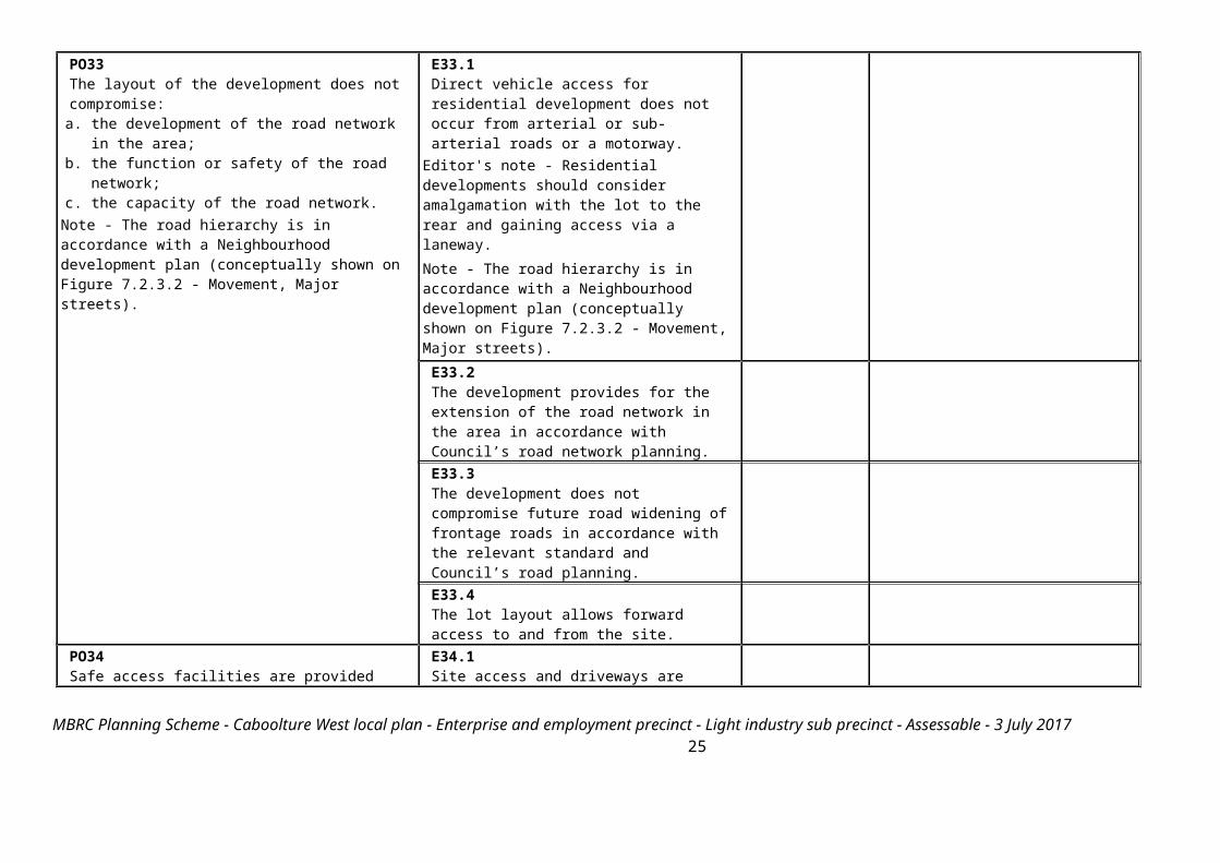
PO33The layout of the development does not compromise:
a. the development of the road network in the area;b. the function or safety of the road network;c. the capacity of the road network.
Note - The road hierarchy is in accordance with a Neighbourhood development plan (conceptually shown on Figure 7.2.3.2 - Movement, Major streets).
E33.1Direct vehicle access for residential development does not occur from arterial or sub-arterial roads or a motorway.
Editor's note - Residential developments should consider amalgamation with the lot to the rear and gaining access via a laneway.Note - The road hierarchy is in accordance with a Neighbourhood development plan (conceptually shown on Figure 7.2.3.2 - Movement, Major streets).
E33.2The development provides for the extension of the road network in the area in accordance with Council’s road network planning.E33.3The development does not compromise future road widening of frontage roads in accordance with the relevant standard and Council’s road planning. E33.4The lot layout allows forward access to and from the site.
PO34Safe access facilities are provided for all vehicles required to access the site.
E34.1Site access and driveways are designed and located in accordance with:
a. Where for a Council-controlled road, AS/NZS2890.1 section 3; or
b. Where for a State-Controlled road, the Safe Intersection Sight Distance requirements in AustRoads and the appropriate IPWEAQ standard drawings, or a copy of a Transport Infrastructure Act 1994, section 62 approval.
E34.2Internal driveways and access ways are designed and constructed in accordance with AS/NZS2890.1 Parking Facilities – Off street car parking and the relevant standards in
MBRC Planning Scheme - Caboolture West local plan - Enterprise and employment precinct - Light industry sub precinct - Assessable - 3 July 2017 19

Planning scheme policy - Integrated design. Note - This includes queue lengths (refer to Schedule 8 Service vehicle requirements), pavement widths and construction.
E34.3Access driveways, manoeuvring areas and loading facilities provide for service vehicles listed in Schedule 8 Service vehicle requirements for the relevant use. The on-site manoeuvring is to be in accordance with Schedule 8 Service vehicle requirements.
PO35Upgrade works (whether trunk or non-trunk) are provided where necessary to:
a. ensure the type or volume of traffic generated by the development does not have a negative impact on the external road network;
b. ensure the orderly and efficient continuation of the active transport network;
c. ensure the site frontage is constructed to a suitable urban standard generally in accordance with Planning scheme policy - Integrated design.
Note - An Integrated Transport Assessment (ITA) may be required to demonstrate compliance with this performance outcome. An ITA should be prepared in accordance with Planning scheme policy - Integrated transport assessment. Note - The road hierarchy is in accordance with a Neighbourhood development plan (conceptually shown on Figure 7.2.3.2 - Movement, Major streets).
Note - To demonstrate compliance with c. of this performance outcome, site frontage works where in existing road reserve (non-trunk) are to be designed and constructed as follows:
i. Where the street is partially established to an urban standard, match the alignment of existing kerb and channel and provide carriageway widening and underground drainage where
E35No example provided.
MBRC Planning Scheme - Caboolture West local plan - Enterprise and employment precinct - Light industry sub precinct - Assessable - 3 July 2017 20

required; or ii. Where the street is not established to an urban
standard, prepare a design that demonstrates how the relevant features of the particular road as shown in the Planning scheme policy - Integrated Design can be achieved in the existing reserve.
Note - Refer to Planning scheme policy - Integrated design for road network and active transport network design standards.
Stormwater PO36Stormwater run-off from the site is conveyed to a point of lawful discharge without causing nuisance or annoyance to any person, property or premises.
Note - Refer to Planning scheme policy - Integrated design for details and examples.Note - A downstream drainage discharge report in accordance with Planning scheme policy - Stormwater management may be required to demonstrate achievement of this performance outcome. Note - A watercourse as defined in the Water Act may be accepted as a lawful point of discharge providing the drainage discharge from the site does not increase the downstream flood levels during events up to and including the 1% AEP storm. An afflux of +20mm may be accepted on Council controlled land and road infrastructure. No worsening is ensured when stormwater is discharged into a catchment that includes State Transport Infrastructure.
No example provided.
PO37Stormwater generated from the development does not compromise the capacity of existing stormwater infrastructure downstream of the site.
Note - A downstream drainage discharge report in accordance with Planning scheme policy - Stormwater management may be required to demonstrate compliance with this performance outcome.
No example provided.
MBRC Planning Scheme - Caboolture West local plan - Enterprise and employment precinct - Light industry sub precinct - Assessable - 3 July 2017 21

PO38Stormwater quality management systems are designed and constructed to minimise the environmental impact of stormwater discharge on surface and underground receiving water quality and meet the design objectives in Tables A and B in Appendix 2 of the SPP. Note - A site-based stormwater management plan prepared by a suitably qualified professional will be required in accordance with Planning scheme policy - Stormwater management.
No example provided.
PO39Easements for drainage purposes are provided over:
a. stormwater pipes located within freehold land if the pipe diameter exceeds 300mm;
b. overland flow paths where they cross more than one property boundary.
Note - Refer to Planning scheme policy - Integrated design for details and examples.Note - Stormwater drainage easement dimensions are provided in accordance with Section 3.8.5 of QUDM.
No example provided.
Site works and construction managementPO40The site and any existing structures are maintained in a tidy and safe condition.
No example provided.
PO41All works on-site are managed to:
a. minimise as far as practicable, impacts on adjoining or adjacent premises and the streetscape in regard to erosion and sedimentation, dust, noise, safety and light;
b. minimise as far as possible, impacts on the natural environment;
c. ensure stormwater discharge is managed in a manner that does not cause nuisance or annoyance to any person or premises;
d. avoid adverse impacts on street streets and their
E41.1Works incorporate temporary stormwater run-off, erosion and sediment controls and trash traps designed in accordance with the Urban Stormwater Quality Planning Guidelines, Planning scheme policy - Stormwater management and Planning scheme policy - Integrated design, including but not limited to the following:
a. stormwater is not discharged to adjacent properties in a manner that differs significantly from pre-existing conditions;
MBRC Planning Scheme - Caboolture West local plan - Enterprise and employment precinct - Light industry sub precinct - Assessable - 3 July 2017 22

critical root zone. b. stormwater discharged to adjoining and downstream properties does not cause scour and erosion;
c. stormwater discharge rates do not exceed pre-existing conditions;
d. the 10% AEP storm event is the minimum design storm for all temporary diversion drains; and
e. the 50% AEP storm event is the minimum design storm for all silt barriers and sedimentation basins.
E41.2Stormwater run-off, erosion and sediment controls are constructed prior to commencement of any clearing work or earthworks and are maintained and adjusted as necessary at all times to ensure their ongoing effectiveness.
Note - The measures are adjusted on-site to maximise their effectiveness.
E41.3The completed earthworks (fill or excavation) area is stabilised using turf, established grass seeding, mulch or sprayed stabilisation techniques to control erosion and sediment and dust from leaving the property. E41.4Where works are proposed in proximity to an existing street tree, an inspection and a root management plan is undertaken by a qualified arborist which demonstrates and ensures that no permanent damage is caused to the tree.
PO42Dust suppression measures are implemented during construction works to protect nearby premises from unreasonable dust impacts.
E42No dust emissions extend beyond the boundaries of the site during soil disturbances and construction works.
MBRC Planning Scheme - Caboolture West local plan - Enterprise and employment precinct - Light industry sub precinct - Assessable - 3 July 2017 23

PO43All works on-site and the transportation of material to and from the site are managed to not negatively impact the existing road network, the amenity of the surrounding area or the streetscape.
Note - Where the amount of imported material is greater than 50m3, a haulage route must be identified and approved by Council.
E43.1Construction traffic including contractor car parking is controlled in accordance with a traffic management plan, prepared in accordance with the Manual of Uniform Traffic Control Devices (MUTCD) to ensure all traffic movements to and from the site are safe. E43.2All contractor car parking is either provided on the development site, or on an alternative site in the general locality which has been set aside for car parking. Contractors' vehicles are generally not to be parked in existing roads.
Note - A Traffic Management Plan may be required for the site in accordance with the Manual of Uniform Traffic Control Devices (MUTCD).
E43.3Any material dropped, deposited or spilled on the roads as a result of construction processes associated with the site are to be cleaned at all times.
PO44All disturbed areas are rehabilitated at the completion of construction.
Note - Refer to Planning scheme policy - Integrated design for details and examples.
E44At completion of construction all disturbed areas of the site are to be:
a. topsoiled with a minimum compacted thickness of fifty (50) millimetres;
b. grassed.Note - These areas are to be maintained during any maintenance period to maximise grass coverage from grass seeding of these areas.
MBRC Planning Scheme - Caboolture West local plan - Enterprise and employment precinct - Light industry sub precinct - Assessable - 3 July 2017 24
PO45The clearing of vegetation on-site:
a. is limited to the area of infrastructure works, buildings areas and other necessary areas for the works;
b. includes the removal of declared weeds and other materials which are detrimental to the intended use of the land;
c. is disposed of in a manner which minimises nuisance and annoyance to existing premises.
Note - No burning of cleared vegetation is permitted.
E45.1All native vegetation to be retained on-site is temporarily fenced or protected prior to and during development works.
Note - No parking of vehicles of storage of machinery or goods is to occur in these areas during development works.
E45.2Disposal of materials is managed in one or more of the following ways:a. all cleared vegetation, declared weeds,
stumps, rubbish, car bodies, scrap metal and the like are removed and disposed of in a Council land fill facility; or
b. all native vegetation with a diameter below 400mm is to be chipped and stored on-site.
PO46Any alteration or relocation in connection with or arising from the development to any service, installation, plant, equipment or other item belonging to or under the control of the telecommunications authority, electricity authorities, the Council or other person engaged in the provision of public utility services is to be carried with the development and at no cost to Council.
No example provided.
EarthworksPO47On-site earthworks are designed to consider the visual and amenity impact as they relate to:
a. the natural topographical features of the site;b. short and long-term slope stability;c. soft or compressible foundation soils;d. reactive soils;e. low density or potentially collapsing soils;f. existing fills and soil contamination that may exist
on-site;
E47.1All cut and fill batters are provided with appropriate scour, erosion protection and run-off control measures including catch drains at the top of batters and lined batter drains as necessary. E47.2Stabilisation measures are provided, as necessary, to ensure long-term stability and low maintenance of steep rock slopes and batters.
MBRC Planning Scheme - Caboolture West local plan - Enterprise and employment precinct - Light industry sub precinct - Assessable - 3 July 2017 25

g. the stability and maintenance of steep rock slopes and batters;
h. excavation (cut) and fill and impacts on the amenity of adjoining lots (e.g. residential)
Note - Filling or excavation works are to be completed within six (6) months of the commencement date.
E47.3All filling or excavation is contained within the site.E47.4All fill placed on-site is:
a. limited to that required for the necessary approved use;
b. clean and uncontaminated (i.e. no building waste, concrete, green waste or contaminated material etc. is used as fill).
E47.5The site is prepared and the fill placed on-site in accordance with AS3798.
Note - The fill is to be inspected and tested in accordance with Planning scheme policy - Operational works inspection, maintenance and bonding procedures.
E47.6Inspection and certification of steep rock slopes and batters may be required by a suitably qualified and experienced RPEQ.
PO48Embankments are stepped, terraced and landscaped to not adversely impact on the visual amenity of the surrounding area.
E48Any embankments more than 1.5 metres in height are stepped, terraced and landscaped.
Figure - Embankment
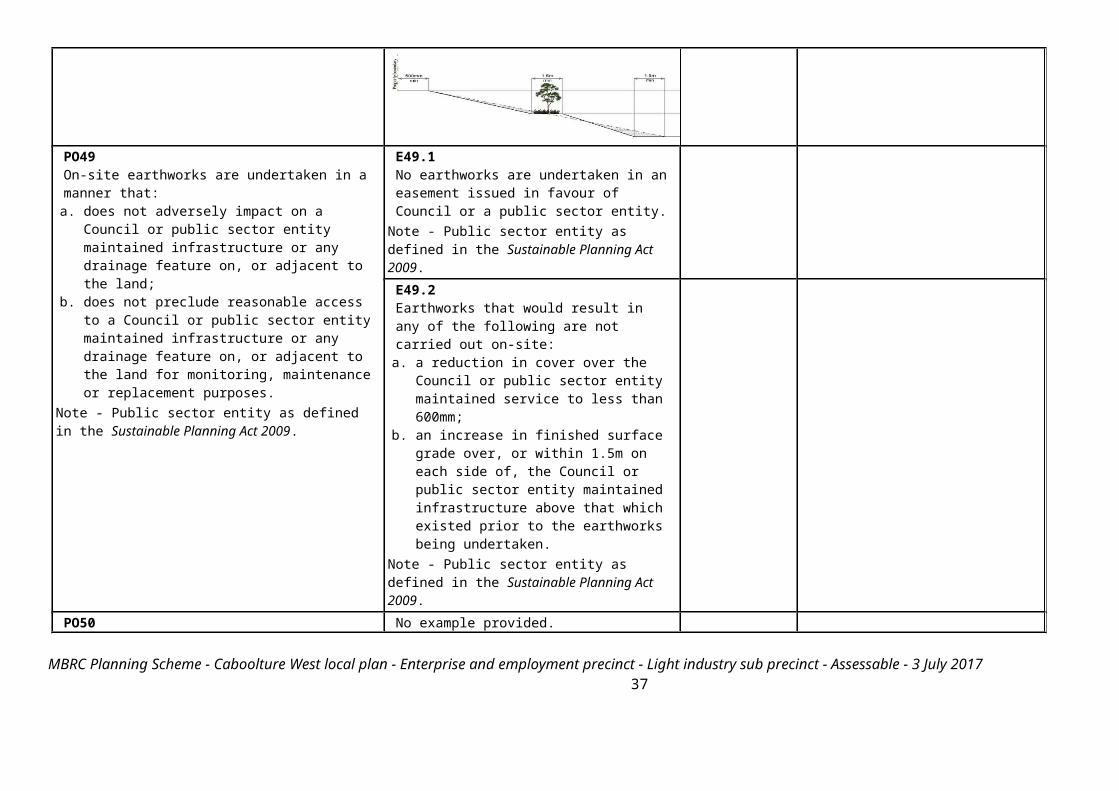
E49.1No earthworks are undertaken in an easement issued in favour of Council or a public sector entity.
Note - Public sector entity as defined in the Sustainable Planning Act 2009.
MBRC Planning Scheme - Caboolture West local plan - Enterprise and employment precinct - Light industry sub precinct - Assessable - 3 July 2017 26

PO49On-site earthworks are undertaken in a manner that:
a. does not adversely impact on a Council or public sector entity maintained infrastructure or any drainage feature on, or adjacent to the land;
b. does not preclude reasonable access to a Council or public sector entity maintained infrastructure or any drainage feature on, or adjacent to the land for monitoring, maintenance or replacement purposes.
Note - Public sector entity as defined in the Sustainable Planning Act 2009.
E49.2Earthworks that would result in any of the following are not carried out on-site:
a. a reduction in cover over the Council or public sector entity maintained service to less than 600mm;
b. an increase in finished surface grade over, or within 1.5m on each side of, the Council or public sector entity maintained infrastructure above that which existed prior to the earthworks being undertaken.
Note - Public sector entity as defined in the Sustainable Planning Act 2009.
PO50Filling or excavation does not result in land instability.
Note - A slope stability report prepared by an RPEQ may be required.
No example provided.
PO51Filling or excavation does not result in
a. adverse impacts on the hydrological and hydraulic capacity of the waterway or floodway;
b. increased flood inundation outside the site;c. any reduction in the flood storage capacity in the
floodway;d. any clearing of native vegetation.
Note - To demonstrate compliance with this outcome, Planning scheme policy - Stormwater management provides guidance on the preparation of a site based stormwater management plan by a suitably qualified professional. Refer to Planning scheme policy - Integrated design for guidance on infrastructure design and modelling requirements.
No example provided.
Retaining walls and structuresPO52All earth retaining structures provide a positive interface with the streetscape and minimise impacts on the amenity of adjoining residents.
E52Earth retaining structures:
a. are not constructed of boulder rocks or timber;
MBRC Planning Scheme - Caboolture West local plan - Enterprise and employment precinct - Light industry sub precinct - Assessable - 3 July 2017 27
b. where height is no greater than 900mm, are provided in accordance with Figure - Retaining on a boundary;
Figure - Retaining on a boundary
c. where height is greater than 900mm but no greater than 1.5m, are to be setback at least the equivalent height of the retaining structure from any property boundary;
d. where height is greater than 1.5m, are to be setback and stepped 1.5m vertical: 1.5m horizontal, terraced, landscaped and drained as shown below.
Figure - Cut
MBRC Planning Scheme - Caboolture West local plan - Enterprise and employment precinct - Light industry sub precinct - Assessable - 3 July 2017 28

Figure - Fill
Fire ServicesNote - The provisions under this heading only apply if:
MBRC Planning Scheme - Caboolture West local plan - Enterprise and employment precinct - Light industry sub precinct - Assessable - 3 July 2017 29
a. the development is for, or incorporates: i. reconfiguring a lot for a community title scheme creating 1 or more vacant lots; orii. material change of use for 2 or more sole occupancy units on the same lot, or within the same community titles scheme; oriii. material change of use for a Tourist park(84) with accommodation in the form of caravans or tents; or iv. material change of use for outdoor sales(54), outdoor processing or outdoor storage where involving combustible materials.
ANDb. none of the following exceptions apply:
i. the distributor-retailer for the area has indicated, in its netserv plan, that the premises will not be served by that entity’s reticulated water supply; or ii. every part of the development site is within 60m walking distance of an existing fire hydrant on the distributor-retailer’s reticulated water supply network,
measured around all obstructions, either on or adjacent to the site. Note - The provisions under this heading do not apply to buildings that are required by the Building Code of Australia to have a fire hydrant system complying with Australian Standard AS 2419.1 (2005) – Fire Hydrant Installations or other fire fighting facilities which provide equivalent protection.
MBRC Planning Scheme - Caboolture West local plan - Enterprise and employment precinct - Light industry sub precinct - Assessable - 3 July 2017 30

E53.1External fire hydrant facilities are provided on site to the standard prescribed under the relevant parts of Australian Standard AS 2419.1 (2005) – Fire Hydrant Installations. Note - For this requirement for accepted development, the following are the relevant parts of AS 2419.1 (2005) that may be applicable:
a. in regard to the form of any fire hydrant - Part 8.5 and Part 3.2.2.1, with the exception that for Tourist parks(84) or development comprised solely of dwellings and their associated outbuildings, single outlet above-ground hydrants or suitably signposted in-ground hydrants would be an acceptable alternative;
b. in regard to the general locational requirements for fire hydrants - Part 3.2.2.2 (a), (e), (f), (g) and (h) as well as Appendix B of AS 2419.1 (2005);
c. in regard to the proximity of hydrants to buildings and other facilities - Part 3.2.2.2 (b), (c) and (d), with the exception that: i. for dwellings and their associated
outbuildings, hydrant coverage need only extend to the roof and external walls of those buildings;
ii. for caravans and tents, hydrant coverage need only extend to the roof of those tents and caravans;
iii. for outdoor sales(54), processing or storage facilities, hydrant coverage is required across the entire area of the outdoor sales(54), outdoor processing and outdoor storage facilities;
d. in regard to fire hydrant accessibility and clearance requirements - Part 3.5 and, where applicable, Part 3.6.
MBRC Planning Scheme - Caboolture West local plan - Enterprise and employment precinct - Light industry sub precinct - Assessable - 3 July 2017 31

PO53Development incorporates a fire fighting system that:
a. satisfies the reasonable needs of the fire fighting entity for the area;
b. is appropriate for the size, shape and topography of the development and its surrounds;
c. is compatible with the operational equipment available to the fire fighting entity for the area;
d. considers the fire hazard inherent in the materials comprising the development and their proximity to one another;
e. considers the fire hazard inherent in the surrounds to the development site;
f. is maintained in effective operating order.Note - The Queensland Fire and Emergency Services is the entity currently providing the fire fighting function for the urban areas of the Moreton Bay Region.
E53.2A continuous path of travel having the following characteristics is provided between the vehicle access point to the site and each external fire hydrant and hydrant booster point on the land:
a. an unobstructed width of no less than 3.5m;b. an unobstructed height of no less than 4.8m;c. constructed to be readily traversed by a 17
tonne HRV fire brigade pumping appliance;d. an area for a fire brigade pumping appliance
to stand within 20m of each fire hydrant and 8m of each hydrant booster point.
E53.3On-site fire hydrant facilities are maintained in effective operating order in a manner prescribed in Australian Standard AS1851 (2012) – Routine service of fire protection systems and equipment.
PO54On-site fire hydrants that are external to buildings, as well as the available fire fighting appliance access routes to those hydrants, can be readily identified at all times from, or at, the vehicular entry point to the development site.
E54For development that contains on-site fire hydrants external to buildings:a. those external hydrants can be seen
from the vehicular entry point to the site; or
b. a sign identifying the following is provided at the vehicular entry point to the site:i. the overall layout of the
development (to scale);ii. internal road names (where used);iii. all communal facilities (where
provided);iv. the reception area and on-site
manager’s office (where provided);v. external hydrants and hydrant
booster points;vi. physical constraints within the
internal roadway system which
MBRC Planning Scheme - Caboolture West local plan - Enterprise and employment precinct - Light industry sub precinct - Assessable - 3 July 2017 32

would restrict access by fire fighting appliances to external hydrants and hydrant booster points.
Note - The sign prescribed above, and the graphics used are to be:a. in a form;b. of a size;c. illuminated to a level;
which allows the information on the sign to be readily understood, at all times, by a person in a fire fighting appliance up to 4.5m from the sign.
PO55Each on-site fire hydrant that is external to a building is signposted in a way that enables it to be readily identified at all times by the occupants of any firefighting appliance traversing the development site.
E55For development that contains on-site fire hydrants external to buildings, those hydrants are identified by way of marker posts and raised reflective pavement markers in the manner prescribed in the technical note Fire hydrant indication system produced by the Queensland Department of Transport and Main Roads.
Note - Technical note Fire hydrant indication system is available on the website of the Queensland Department of Transport and Main Roads.
Use specific criteriaIndustrial land usesPO56Ancillary Office(53), administration functions, retail sales and customer service components do not compromise the primary use of the site for industrial purposes or compromise the viability, role or function of the Caboolture West's centres network.
E56The combined area of ancillary non-industrial activities, including but not limited to Offices(53), administration functions, display and retail sale of commodities, articles or goods resulting from the industrial processes on-site, does not exceed 30% of the GFA or 500m2, whichever is the lesser.
PO57 No example provided.
MBRC Planning Scheme - Caboolture West local plan - Enterprise and employment precinct - Light industry sub precinct - Assessable - 3 July 2017 33

Buildings directly adjoining non-Light industry sub-precinct land:a. are compatible with the character of the
adjoining area;b. minimise overlooking and overshadowing;c. maintain privacy;d. do not cause significant loss of amenity to
neighbouring residents by way of noise, vibration, odour, lighting, traffic generation and hours of operation.
PO58Non-industrial components of buildings (including Offices(53) and retail areas) are designed as high quality architectural features and incorporate entry area elements such as forecourts, awnings and the architectural treatment of roof lines and fascias.
No example provided.
Non-industrial land usesPO59With the exception of Caretaker's accommodation(10), residential and other sensitive land uses do not establish within the sub-precinct.
No example provided.
PO60Non-industrial uses:a. are consolidated with existing non-industrial
uses in the sub-precinct;b. do not compromise the viability, role or
function of Caboolture West's centres network;
c. are not subject to adverse amenity impacts or risk to health from industrial activities;
d. do not constrain the function or viability of future industrial activities in Light industry sub-precinct.
Note - The submission of a Economic Impact Report or Hazard and Nuisance Mitigation Plan may be required to justify compliance with this outcome.
No example provided.
MBRC Planning Scheme - Caboolture West local plan - Enterprise and employment precinct - Light industry sub precinct - Assessable - 3 July 2017 34

PO61Traffic generated by non-industrial uses does not detrimentally impact the operation and functionality of the external road network.
No example provided.
PO62Where located on a local street, non-industrial uses provide only direct convenience retail or services to the industrial workforce.
No example provided.
PO63The design of non-industrial buildings in the sub-precinct:a. adds visual interest to the streetscape (e.g.
variation in materials, patterns, textures and colours, a consistent building line, blank walls that are visible from public places are treated to not negatively impact the surrounding amenity);
b. contributes to a safe environment (e.g. through the use of lighting and not resulting in concealed recesses or potential entrapment areas);
c. incorporates architectural features within the building facade at the street level to create human scale (e.g. awnings).
No example provided.
PO64Building entrances:a. are readily identifiable from the road frontage;b. add visual interest to the streetscape;c. are designed to limit opportunities for
concealment;d. are located and oriented to favour active and
public transport usage by connecting to pedestrian footpaths on the street frontage and adjoining sites.
Note - The design provisions for footpaths outlined in Planning scheme policy - Integrated design may assist in demonstrating compliance with this outcome.
E64.1The main entrance to the building is clearly visible from and addresses the primary street frontage.E64.2Where the building does not adjoin the street frontage, a dedicated and sealed pedestrian footpath is provided between the street frontage and the building entrance.
MBRC Planning Scheme - Caboolture West local plan - Enterprise and employment precinct - Light industry sub precinct - Assessable - 3 July 2017 35

PO65Development of Caretaker's accommodation(10): a. does not compromise the productivity of the
use occurring on-site and in the surrounding area;
b. is domestic in scale;c. provides adequate car parking provisions
exclusive on the primary use of the site;d. is safe for the residents;e. has regard to the open space and recreation
needs of the residents.
E65Caretaker's accommodation(10): a. has a maximum GFA is 80m2; b. does not gain access from a separate
driveway to that of the industrial use;c. provides a minimum 16m2 of private open
space directly accessible from a habitable room;
d. provides car parking in accordance with the car parking rates table.
Major electricity infrastructure(43), Substation(80) and Utility installation(86)
PO66The development does not have an adverse impact on the visual amenity of a locality and is:
a. high quality design and construction;b. visually integrated with the surrounding area;c. not visually dominant or intrusive;d. located behind the main building line;e. below the level of the predominant tree canopy or
the level of the surrounding buildings and structures;
f. camouflaged through the use of colours and materials which blend into the landscape;
g. treated to eliminate glare and reflectivity;h. landscaped;i. otherwise consistent with the amenity and
character of the zone and surrounding area.
E66.1Development is designed to minimise surrounding land use conflicts by ensuring infrastructure, buildings, structures and other equipment:
a. are enclosed within buildings or structures;b. are located behind the main building line;c. have a similar height, bulk and scale to the
surrounding fabric;d. have horizontal and vertical articulation
applied to all exterior walls.E66.2A minimum 3m wide strip of dense planting is provided around the outside of the fenced area, between the development and street frontage, side and rear boundaries.
PO67Infrastructure does not have an impact on pedestrian health and safety.
E67Access control arrangements:
a. do not create dead-ends or dark alleyways adjacent to the infrastructure;
b. minimise the number and width of crossovers and entry points;
c. provide safe vehicular access to the site;d. do not utilise barbed wire or razor wire.
MBRC Planning Scheme - Caboolture West local plan - Enterprise and employment precinct - Light industry sub precinct - Assessable - 3 July 2017 36
PO68All activities associated with the development occur within an environment incorporating sufficient controls to ensure the facility:
a. generates no audible sound at the site boundaries where in a residential setting; or
b. meet the objectives as set out in the Environmental Protection (Noise) Policy 2008.
E68All equipment which produces audible or non-audible sound is housed within a fully enclosed building incorporating sound control measures sufficient to ensure noise emissions meet the objectives as set out in the Environmental Protection (Noise) Policy 2008.
Telecommunications facility (81)
Editor's note - In accordance with the Federal legislation Telecommunications facilities (81)must be constructed and operated in a manner that will not cause human exposure to electromagnetic radiation beyond the limits outlined in the Radiocommunications (Electromagnetic Radiation - Human Exposure) Standard 2003 and Radio Protection Standard for Maximum Exposure Levels to Radiofrequency Fields - 3Khz to 300Ghz. PO69Telecommunications facilities(81) are co-located with existing telecommunications facilities(81), Utility installation(86), Major electricity infrastructure(43) or Substation(80) if there is already a facility in the same coverage area.
E69.1New telecommunication facilities(81) are co-located on existing towers with new equipment shelter and associated structures positioned adjacent to the existing shelters and structures. E69.2If not co-located with an existing facility, all co-location opportunities have been investigated and fully exhausted within a 2km radius of the site.
PO70A new Telecommunications facility(81) is designed and constructed to ensure co-masting or co-siting with other carriers both on the tower or pole and at ground level is possible in the future.
E70A minimum of 45m2 is available at ground level to allow for additional equipment shelters and associated structures for the purpose of co-locating on the proposed facility.
PO71Telecommunications facilities(81) do not conflict with lawful existing land uses both on and adjoining the site.
E71The development results in no net reduction in the minimum quantity and standard of landscaping, private or communal open space or car parking spaces required under the planning scheme or under an existing development approval.
PO72The Telecommunications facility(81) does not have an adverse impact on the visual amenity of a
E72.1Where in an urban area, the development does not protrude more than 5m above the
MBRC Planning Scheme - Caboolture West local plan - Enterprise and employment precinct - Light industry sub precinct - Assessable - 3 July 2017 37

locality and is: a. high quality design and construction;b. visually integrated with the surrounding area;c. not visually dominant or intrusive;d. located behind the main building line;e. below the level of the predominant tree canopy or
the level of the surrounding buildings and structures;
f. camouflaged through the use of colours and materials which blend into the landscape;
g. treated to eliminate glare and reflectivity;h. landscaped;i. otherwise consistent with the amenity and
character of the zone and surrounding area.
level of the existing treeline, prominent ridgeline or building rooftops in the surrounding townscape. E72.2In all other areas towers do not exceed 35m in height.E72.3Towers, equipment shelters and associated structures are of a design, colour and material to:
a. reduce recognition in the landscape;b. reduce glare and reflectivity.E72.4All structures and buildings are setback behind the main building line and a minimum of 10m from side and rear boundaries, except where in the Industry and Extractive industry zones, the minimum side and rear setback is 3m. Where there is no established building line the facility is located at the rear of the site.E72.5The facility is enclosed by security fencing or by other means to ensure public access is prohibited.E72.6A minimum 3m wide strip of dense planting is provided around the perimeter of the fenced area, between the facility and street frontage and adjoining uses.
Note - Landscaping is provided in accordance with Planning scheme policy - Integrated design.Note - Council may require a detailed landscaping plan, prepared by a suitably qualified person, to ensure compliance with Planning scheme policy - Integrated design.
PO73Lawful access is maintained to the site at all times that does not alter the amenity of the landscape or
E73An Access and Landscape Plan demonstrates how 24 hour vehicular access will be obtained
MBRC Planning Scheme - Caboolture West local plan - Enterprise and employment precinct - Light industry sub precinct - Assessable - 3 July 2017 38

surrounding uses. and maintained to the facility in a manner that is appropriate to the site’s context.
PO74All activities associated with the development occur within an environment incorporating sufficient controls to ensure the facility generates no audible sound at the site boundaries where in a residential setting.
E74All equipment comprising the Telecommunications facility(81) which produces audible or non-audible sound is housed within a fully enclosed building incorporating sound control measures sufficient to ensure no noise from this equipment can be heard, or felt at the site boundary.
Values and constraints criteriaNote - The relevant values and constraints criteria do not apply where the development is consistent with a current Development permit for Reconfiguring a lot or Material change of use or Operational work, where that approval has considered and addressed (e.g. through a development footprint plan (or similar in the case of Landslide hazard) or conditions of approval) the identified value or constraint under this planning scheme. Acid sulfate soils - (refer Overlay map - Acid sulfate soils to determine if the following assessment criteria apply)Note - To demonstrate achievement of the performance outcome, an Acid sulfate soils (ASS) investigation report and soil management plan is prepared by a qualified engineer. Guidance for the preparation an ASS investigation report and soil management plan is provided in Planning scheme policy - Acid sulfate soils. PO75Development avoids disturbing acid sulfate soils. Where development disturbs acid sulfate soils, development:
a. is managed to avoid or minimise the release of surface or groundwater flows containing acid and metal contaminants into the environment;
b. protects the environmental and ecological values and health of receiving waters;
c. protects buildings and infrastructure from the effects of acid sulfate soils.
E75Development does not involve:
a. excavation or otherwise removing of more than 100m3 of soil or sediment where below than 5m Australian Height datum AHD; or
b. filling of land of more than 500m3 of material with an average depth of 0.5m or greater where below the 5m Australian Height datum AHD.
Heritage and landscape character (refer Overlay map - Heritage and landscape character to determine if the following assessment criteria apply)Note - To assist in demonstrating achievement of heritage performance outcomes, a Cultural heritage impact assessment report is prepared by a suitably qualified person verifying the proposed development is in accordance with The Australia ICOMOS Burra Charter.
Note - To assist in demonstrating achievement of this performance outcome, a Tree assessment report is prepared by a qualified arborist in accordance with Planning scheme policy – Heritage and landscape character. The Tree assessment report will also detail the measures adopted in accordance with AS 4970-2009 Protection of trees on development sites.
MBRC Planning Scheme - Caboolture West local plan - Enterprise and employment precinct - Light industry sub precinct - Assessable - 3 July 2017 39

Note - Places, including sites, objects and buildings having local cultural heritage significance, are identified on Overlay map - Heritage and landscape character and listed in Schedule 1 of Planning scheme policy - Heritage and landscape character. Places also having cultural heritage significance at a State level and being entered in the Queensland Heritage Register, are also identified in Schedule 1 of Planning scheme policy - Heritage and landscape character. PO76Development will:
a. not diminish or cause irreversible damage to the cultural heritage values present on the site, and associated with a heritage site, object or building;
b. protect the fabric and setting of the heritage site, object or building;
c. be consistent with the form, scale and style of the heritage site, object or building;
d. utilise similar materials to those existing, or where this is not reasonable or practicable, neutral materials and finishes;
e. incorporate complementary elements, detailing and ornamentation to those present on the heritage site, object or building;
f. retain public access where this is currently provided.
E76Development is for the preservation, maintenance, repair and restoration of a site, object or building of cultural heritage value.
Note - A cultural heritage conservation management plan for the preservation, maintenance, repair and restoration of a site, object or building of cultural heritage value is prepared in accordance with Planning scheme policy - Heritage and landscape character. The plan is sent to, and approved by Council prior to the commencement of any preservation, maintenance, repair and restoration works.
PO77Demolition and removal is only considered where:
a. a report prepared by a suitably qualified conservation architect or conservation engineer demonstrates that the building is structurally unsound and is not reasonably capable of economic repair; or
b. demolition is confined to the removal of outbuildings, extensions and alterations that are not part of the original structure; or
c. limited demolition is performed in the course of repairs, maintenance or restoration; or
d. demolition is performed following a catastrophic event which substantially destroys the building or object.
No example provided.
MBRC Planning Scheme - Caboolture West local plan - Enterprise and employment precinct - Light industry sub precinct - Assessable - 3 July 2017 40
PO78Where development is occurring on land adjoining a site of cultural heritage value, the development is to be sympathetic to and consistent with the cultural heritage values present on the site and not result in their values being eroded, degraded or unreasonably obscured from public view.
No example provided.
Infrastructure buffer areas (refer Overlay map – Infrastructure buffers to determine if the following assessment criteria apply)PO79Development within a High voltage electricity line buffer:
a. is located and designed to avoid any potential adverse impacts on personal health and wellbeing from electromagnetic fields;
b. is located and designed in a manner that maintains a high level of security of supply;
c. is located and designed so not to impede upon the functioning and maintenance of high voltage electrical infrastructure.
E79Except where located on an approved Neighbourhood development plan, development does not involve the construction of any buildings or structures within a high voltage electricity line buffer.
PO80Development within a bulk water supply infrastructure buffer is located, designed and constructed to:
a. protect the integrity of the bulk water supply infrastructure;
b. Maintains adequate access for any required maintenance or upgrading work to the bulk water supply infrastructure.
E80Except where located on an approved Neighbourhood development plan, development does not involve the construction of any buildings or structures within a bulk water supply infrastructure buffer.
PO81Development is located and designed to maintain required access to Bulk water supply infrastructure.
E81Development does not restrict access to Bulk water supply infrastructure of any type or size, having regard to (among other things):
a. buildings or structures;b. gates and fences;c. storage of equipment or materials;d. landscaping or earthworks or stormwater or
other infrastructure.Overland flow path (refer Overlay map - Overland flow path to determine if the following assessment criteria apply)
MBRC Planning Scheme - Caboolture West local plan - Enterprise and employment precinct - Light industry sub precinct - Assessable - 3 July 2017 41

Note - The applicable river and creek flood planning levels associated with defined flood event (DFE) within the inundation area can be obtained by requesting a flood check property report from Council. PO82Development:
a. minimises the risk to persons from overland flow;
b. does not increase the potential for damage from overland flow either on the premises or other premises, public land, watercourses, roads or infrastructure.
No example provided.
PO83Development:
a. maintains the conveyance of overland flow predominantly unimpeded through the premises for any event up to and including the 1% AEP for the fully developed upstream catchment;
b. does not concentrate, intensify or divert overland flow onto an upstream, downstream or surrounding property.
Note - A report from a suitably qualified Registered Professional Engineer Queensland is required certifying that the development does not increase the potential for significant adverse impacts on an upstream, downstream or surrounding premises. Note - Reporting to be prepared in accordance with Planning scheme policy – Flood hazard, Coastal hazard and Overland flow.
E83No example provided.
PO84Development does not:
a. directly, indirectly or cumulatively cause any increase in overland flow velocity or level;
b. increase the potential for flood damage from overland flow either on the premises or other premises, public lands, watercourses, roads or infrastructure.
Note - Open concrete drains greater than 1m in width are not an acceptable outcome, nor are any other design options that may increase scouring.
No example provided.
MBRC Planning Scheme - Caboolture West local plan - Enterprise and employment precinct - Light industry sub precinct - Assessable - 3 July 2017 42

PO85Development ensures that public safety and the risk to the environment are not adversely affected by a detrimental impact of overland flow on a hazardous chemical located or stored on the premises.
E85Development ensures that a hazardous chemical is not located or stored in an Overland flow path area.
Note - Refer to the Work Health and Safety Act 2011 and associated Regulation and Guidelines, the Environmental Protection Act 1994 and the relevant building assessment provisions under the Building Act 1975 for requirements related to the manufacture and storage of hazardous substances.
PO86Development which is not in a Rural zone ensures that overland flow is not conveyed from a road or public open space onto a private lot.
E86Development which is not in a Rural zone that an overland flow paths and drainage infrastructure is provided to convey overland flow from a road or public open space area away from a private lot.
PO87Development ensures that inter-allotment drainage infrastructure, overland flow paths and open drains through private property cater for overland flows for a fully developed upstream catchment and are able to be easily maintained.
Note - A report from a suitably qualified Registered Professional Engineer Queensland is required certifying that the development does not increase the potential for significant adverse impacts on an upstream, downstream or surrounding premises. Note - Reporting to be prepared in accordance with Planning scheme policy – Flood hazard, Coastal hazard and Overland flow
E87.1Development ensures that roof and allotment drainage infrastructure is provided in accordance with the following relevant level as identified in QUDM:
a. Urban area – Level III;b. Rural area – N/A;c. Industrial area – Level V;d. Commercial area – Level V.E87.2Development ensures that inter-allotment drainage infrastructure is designed to accommodate any event up to and including the 1% AEP for the fully developed upstream catchment.
PO88Development protects the conveyance of overland flow such that an easement for drainage purposes is provided over:a. a stormwater pipe if the nominal pipe
diameter exceeds 300mm;
No example provided.
MBRC Planning Scheme - Caboolture West local plan - Enterprise and employment precinct - Light industry sub precinct - Assessable - 3 July 2017 43

b. an overland flow path where it crosses more than one premises;
c. inter-allotment drainage infrastructure.Note - Refer to Planning scheme policy - Integrated design for details and examples.Note - Stormwater Drainage easement dimensions are provided in accordance with Section 3.8.5 of QUDM.Additional criteria for development for a Park(57)
PO89Development for a Park(57) ensures that the design and layout responds to the nature of the overland flow affecting the premises such that: a. public benefit and enjoyment is maximised;b. impacts on the asset life and integrity of park
structures is minimised;c. maintenance and replacement costs are
minimised.
E89Development for a Park(57) ensures works are provided in accordance with the requirements set out in Appendix B of the Planning scheme policy - Integrated design.
MBRC Planning Scheme - Caboolture West local plan - Enterprise and employment precinct - Light industry sub precinct - Assessable - 3 July 2017 44