€¦ · Web viewBorn in Egypt, he wrote two great works, the Almagest (on astronomy) and...
11
APPENDIX A ANCIENT MAPS: GRECO-ROMAN VIEWS OF THE WORLD MAP 1 Hecataeus of Miletus was well travelled. This map is based on his writings in Description of the Earth. Written in approximately 500 B.C., it shows some knowledge of India. (Wheatley, p. 123) Maps ETC (Educational Technology Clearinghouse, University of South Florida) http://etc.usf.edu/maps/pages/10400/10485/10485.htm Anaximander of Miletus is credited as being the first person to draw a map of the world. This map by Hecataeus, also of Miletus, is similar to the one described by Herodotus. (Berthon, p. 19)
Transcript of €¦ · Web viewBorn in Egypt, he wrote two great works, the Almagest (on astronomy) and...

APPENDIX A
ANCIENT MAPS: GRECO-ROMAN VIEWS OF THE WORLD
MAP 1
Hecataeus of Miletus was well travelled. This map is based on his writings in Description of the Earth. Written in approximately 500 B.C., it shows some knowledge of India.
(Wheatley, p. 123)
Maps ETC (Educational Technology Clearinghouse, University of South Florida)http://etc.usf.edu/maps/pages/10400/10485/10485.htm
Anaximander of Miletus is credited as being the first person to draw a map of the world. This map by Hecataeus, also of Miletus, is similar to the one described by Herodotus.
(Berthon, p. 19)
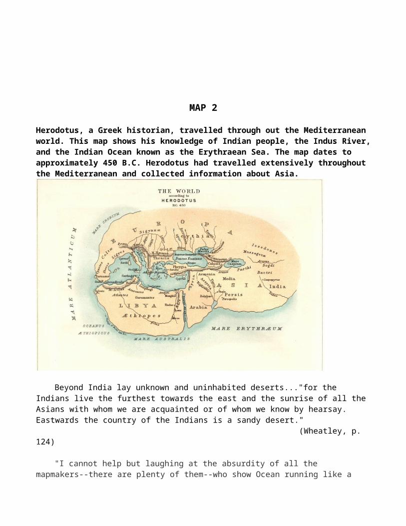
MAP 2
Herodotus, a Greek historian, travelled through out the Mediterranean world. This map shows his knowledge of Indian people, the Indus River, and the Indian Ocean known as the Erythraean Sea. The map dates to approximately 450 B.C. Herodotus had travelled extensively throughout the Mediterranean and collected information about Asia.
Beyond India lay unknown and uninhabited deserts..."for the Indians live the furthest towards the east and the sunrise of all the Asians with whom we are acquainted or of whom we know by hearsay. Eastwards the country of the Indians is a sandy desert."
(Wheatley, p. 124)
"I cannot help but laughing at the absurdity of all the mapmakers--there are plenty of them--who show Ocean running like a river round a perfectly circular earth, with Asia and Europe of the same size." Herodotus said of the three known continents (Europe, Asia, and Africa) "Europe is as long as the other two put together, and for breadth is not, in my opinion, even to be compared with them."
(Berthon, p. 19)
Herodotus wrote about the Egyptian king Neco who ruled from 616 to 600 B.C. He sent out a fleet of Phoenician ships to sail south on the Red Sea to attempt to sail around the east coast of Africa. Although the Phoenician records are lost, the voyage was said to have taken nearly three years before the ships entered the Mediterranean at the Pillars of Hercules (Strait of Gibralter). Said Herodotus,
"These men made a statement which I do not believe myself, that they sailed on a westerly course 'round the southern end of Libya. They had the sun on the right -- to northward of them." Herodotus could not believe that Africa was so large as to extend into the southern hemisphere.
(Berthon, p. 20)
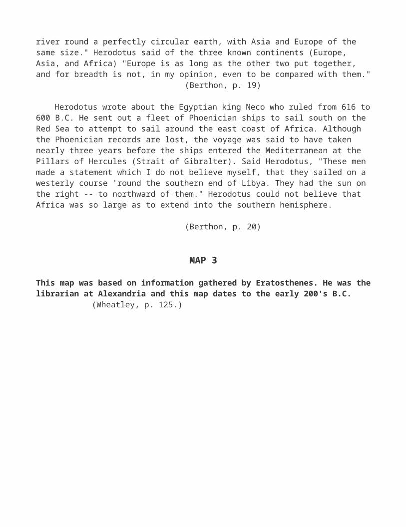
MAP 3
This map was based on information gathered by Eratosthenes. He was the librarian at Alexandria and this map dates to the early 200's B.C.
(Wheatley, p. 125.)
Source: Atlantis in the Java Sea https://atlantisjavasea.com/tag/eratosthenes/
Because of the campaigns of Alexander the Great, knowledge of Asia greatly increased during the century before Eratosthenes (334-323 B. C.). As the librarian at Alexandria, his ideas were based on the records of various government officials and envoys who had traveled as far as India. This map clearly shows Sri Lanka, known as "Taprobane" as well as the mouth of the Ganges River. Southeast Asia was not mentioned in his writings.
(Wheatley, p. 124)
Eratosthenes was a brilliant mapmaker. He was the first person to calculate the circumference of the earth based on the position of the sun on the summer solstice and the location of the cities. Alexandria and Syrene. His result was within 200

miles of what we know today: 24,862 miles around the earth. Berthon, p. 25)
MAP 4
Strabo, the author of a seventeen-volume encyclopedia about the known world, believed that the inhabitable world was twice as wide as it was long.
(Berthon, p. 21, 22, & 25.)
Ancient Greek Geography - Maps. GlobalSecurity.orghttp://www.globalsecurity.org/military/world/europe/gr-history-ancient-geography-
maps.htm
Strabo's extraordinary writings in the seventeen-volume encyclopedia Geography (18 A.D.) contained all the known information about the human, animal and physical world. He believed that the inhabitable world was twice as broad as it was long. Strabo did not believe ships or humans could survive travel south into the "torrid zone" where seas were so large they were not crossable. From his travels he learned of Meroe (Khartoum) and the "cinnamon country" to the south.
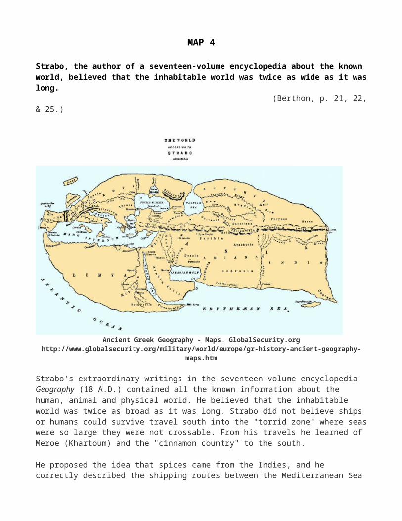
He proposed the idea that spices came from the Indies, and he correctly described the shipping routes between the Mediterranean Sea and India.
(Berthon, p. 25; Suarez, p. 65)
MAP 5
In 43 A.D. the Roman geographer Pomponius Mela was the first to mention theSoutheast Asian islands of Chryse and Argyre, legendary lands of gold and silver.
(Wheatley, p. 128-129.)
Alamy Stock Photo http://www.alamy.com/stock-photo-1889-map-of-the-world-according-to-pomponius-mela-about-ad-50-53456174.html
In 43 A.D. the Roman geographer, Pomponius Mela, was the first writer to make specific reference to Southeast Asia in his popular book on geography. For the next thousand years his mention of Chryse and Agyre were used to describe the legendary islands. He wrote, "Apart from those areas too warm for human settlement, the region between the Indus and the Ganges is occupied by black

peoples resembling Ethiopians. between Colis andTamus the coast runs straight. It is inhabited by retiring people who garner rich harvests from the sea . . . In the vicinity of Tamus is the island of Chryse ; in the vicinity of the Ganges that of Argyre.According to olden writers, the soil of the former consists of gold, that of the latter is of silver; and it seems very probable that either the name arises from this fact or the legend derives from the name." Pomponius Mela saw the need to balance the landmass on one side of the world with a counter-earth he named Antichthon.
(Wheatley, p. 128-129; Berthon, p. 33)
MAP 6
The ancient world as depicted by Ptolemy in 150 A.D. Notice that Africa extends far to the south, joining Asia in the Far East. The Indian Ocean is a large sea. (Miller, p. 276.)
Barry Lawrence Ruderman Antique Maps www.raremaps.com/gallery/archivedetail/14277/Untitled_Map_of_the_World_1482_Ulm_
Ptolemy_World_Map/Ptolemy-Holle.html
Claudius Ptolemy influenced geography for more than one thousand years. Born in Egypt, he wrote two great works, the Almagest (on astronomy) and Geography while librarian at Alexandria from 127 - 150 A.D.
Knowledge of Asia, and the "Golden Peninsula" of Southeast Asia in particular, was described by the geography Marinus of Tyre. Ptolemy used his writings as the
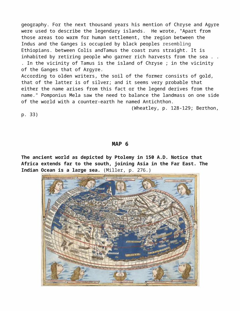
foundation for his Geography. His work in astronomy was largely based on the ideas of Hipparchus of Rhodes (three hundred years earlier) who proposed dividing the length and breadth of the world by 360 degrees. Miscalculations of the earth's circumference by later geographers caused Ptolemy to use figures for a much smaller world. This map shows lines of latitude and longitude not accurate by today's coordinates.
Ptolemy's map shows Africa extending all the way to Asia, ending the idea that it was sur-rounded by water. Instead the Indian Ocean becomes a vast inland sea. The region called "Terra Incognita" was designed to balance the global landmass. Ptolemy's achievement was to depict the earth as a sphere on a map with curving coordinates of latitude and longitude. More than 1,300 years later, his ideas were rediscovered during the Renaissance. (Berthon, p. 32-36; Suarez, p. 63-64)
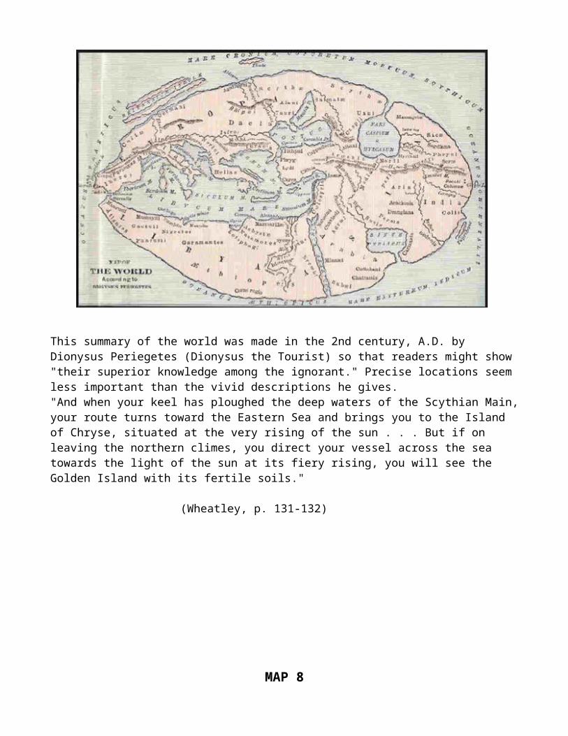
MAP 7
Dionysus Perigetes (the Tourist) depicts the world in the second century, A.D. The Erythraeum Sea surrounds the known world. Chyse, "the Golden" is shown.
(Wheatley, p. 132)
This summary of the world was made in the 2nd century, A.D. by Dionysus Periegetes (Dionysus the Tourist) so that readers might show "their superior knowledge among the ignorant." Precise locations seem less important than the

vivid descriptions he gives. "And when your keel has ploughed the deep waters of the Scythian Main, your route turns toward the Eastern Sea and brings you to the Island of Chryse, situated at the very rising of the sun . . . But if on leaving the northern climes, you direct your vessel across the sea towards the light of the sun at its fiery rising, you will see the Golden Island with its fertile soils." (Wheatley, p. 131-132)
MAP 8
The thirteenth century "Beatus" map shows Paradise from which flows the four rivers: the Ganges, the Nile, the Tigris and the Euphrates. Based on the Judeo-Christian belief in Adam and Eve's banishment from the Garden of Eden, this map places Paradise in Southeast Asia. (Suarez, p. 70)
Sarin Blanco Teller, Napmundi Del Beato Burgo de Osmahttp://sarin-eltallerdesarin.blogspot.com/2013/03/mapamundi-burgo-de-osma-sobre-tapa-de.html
Medieval European maps, showing the Judeo-Christian belief in the banishment of Adam and Eve from Paradise due to Original Sin, depict Southeast Asia as the site of the Biblical Eden. This early 13th century "Beatus" map shows four rivers which were believed to flow from there: the Ganges, Nile, Tigris and Euphrates. The islands of Chryse and Argyre are shown directly off the coast of Paradise. Travelers' accounts of Southeast Asia reinforced this idea.
"Within this wall there were the fairest and most crystal fountains in the whole world: and about the said fountains there were the most beautiful virgins in great number, and goodly horses also, and in a word, every-thing that could be devised for bodily solace and delight, and therefore the inhabitants of the country call the same place by the name of Paradise." (Suarez, p. 69-70)


![Physics and Philosophy in the Almagest · The Almagest begins with a preface [I, 1; Hei 1, 4]1) in which the whole work is dedicated toa certainSyrus, aboutwhom we know nothing. He](https://static.fdocuments.in/doc/165x107/6081be2de8bb6a33290438e5/physics-and-philosophy-in-the-almagest-the-almagest-begins-with-a-preface-i-1.jpg)