The AIB material is based on Kenya, an LEDC. It looks at a bottom- up aid project (Riders for...
20
Last and final thoughts before the exam, tomorrow.. AQA GEO4B GEOGRAPHICAL ISSUE EVALUATION
-
Upload
esmond-green -
Category
Documents
-
view
220 -
download
0
Transcript of The AIB material is based on Kenya, an LEDC. It looks at a bottom- up aid project (Riders for...

Last and final thoughts before the exam,
tomorrow..
AQA GEO4BGEOGRAPHICAL ISSUE
EVALUATION

© ZigZag Education, 2015 2
The AIB material is based on Kenya, an LEDC. It looks at a bottom-up aid project (Riders for Health) and how Kenya is working to meet its Millennium Development Goals.
This material is focused on the topic of Development and Globalisation (A2) as well as Health Issues (AS). For background purposes, some knowledge of Weather and Climate and associated Hazards (A2), and Population Issues (AS) may be beneficial.
Within the topic, the focus is on: An overview of the NGO ‘Riders for Health’ A series of maps portraying the physical and human geography of Kenya An assessment of the health service in Kenya A report into the progress Kenya is making towards the Millennium
Development Goals
WHAT IS IT ABOUT?

3
This resource booklet is so heavily focused on just one topic area, you will really need to ‘think like a geographer’ in order to show detailed understanding of the problems facing countries trying to develop.You have to understand the human and physical geography of the country and be able to explain how this constrains development.You need a full background knowledge of health care in Kenya, the issues preventing a more coherent system, and the role of NGOs will all help produce a coherent understanding of why Kenya is struggling to meet its MDGs.Having a clear understanding of potential future threats will help you assess the suggestions for helping the country move towards achieving the MDGs. Bringing in case study knowledge of strategies used effectively elsewhere will help add synopticity to answers (and quality).
CAN YOU ANSWER WITH SYNOPTICITY?CAN YOU STAND OUT FROM THE REST?
© ZigZag Education, 2015 4
Let’s remind ourselves
© ZigZag Education, 2015 5
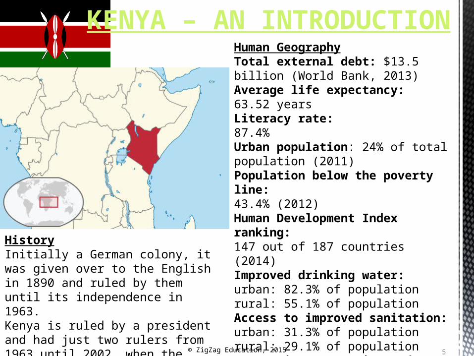
KENYA – AN INTRODUCTIONHuman Geography
Total external debt: $13.5 billion (World Bank, 2013) Average life expectancy: 63.52 years Literacy rate: 87.4% Urban population: 24% of total population (2011)Population below the poverty line: 43.4% (2012)Human Development Index ranking: 147 out of 187 countries (2014)Improved drinking water: urban: 82.3% of population rural: 55.1% of populationAccess to improved sanitation:urban: 31.3% of population rural: 29.1% of populationCorruption Perception Index139 out of 174 countries (2012)
HistoryInitially a German colony, it was given over to the English in 1890 and ruled by them until its independence in 1963. Kenya is ruled by a president and had just two rulers from 1963 until 2002, when the country seemed to have its first real democratic election.

6© ZigZag Education, 2015Source: Ministry of Health, 2007
Central
Coast
Eastern
North East
ern
Nairobi
Nyanza
Rift Vall
ey
Weste
rn0
10,00020,00030,00040,00050,00060,00070,00080,00090,000
100,000
Population per Physician
Province
Popu
latio
n /
Phys
icia
n
Despite Nairobi being the capital city and having the oldest and largest training hospital in the country, the population per physician is not the lowest as one might expect.

7
The climate varies considerably across the country with glaciers found on Mount Kenya, Africa's second highest peak. Parts of the country suffer from recurring drought, while others face flooding during rainy seasons.
Lowest point: Indian Ocean 0 m Highest point: Mount Kenya 5,199 m Depending on the number of small islands included, Kenya has a coastline of around
600 km. The Kenyan coastal region is mainly low-lying and has an extensive fossil reef lying a
few metres above present sea level. A line of hills, reaching to around 300 m, back the coastal plain.
Western Kenya is characterised by an area of higher land and here agriculture is at its most productive. The Great Rift Valley cuts through this area creating fertile soils.
Kenya is crossed by a number of large rivers, although they are all prone to seasonal fluctuations. The Galana and Tana both flow towards the Indian Ocean, while the Mara and Nzoia are used for irrigation in the croplands in the west of the country.
A number of lakes are located in Kenya, mainly formed by the Great Rift Valley: Lake Turkana in the north-eastern part of the country is the largest of these, but there are also Lake Naivasha, Lake Nakuru, Lake Baringo and Lake Bogoria. In addition, part of Lake Victoria lies inside Kenya’s south-western corner.
KENYA’S PHYSICAL GEOGRAPHY

8© ZigZag Education, 2015
KENYA’S TEMPERATUREAs with its rainfall, Kenya experiences temperature variation across the country.The coldest areas are associated with the highest relief (Mount Kenya) and are also most centrally located in the country. The hottest region is between 2 °N and 2 °S of the equator along the eastern part of the country, as well as in the far north around Lake Turkana.
26.5°C-29.5°C
23.5°C-26.5°C
18.5°C-21.0°C
15.5°C-18.5°C
21.0°C-23.5°C
13.0°C-15.5°C
13.0°C-10.0°C
10.0°C-7.0°C
7.0°C-4.5°C4.5°C-1.5°C

99
ATTACK ON GARISSA UNIVERSITY COLLEGE, KENYA 2ND APRIL
On 2nd April, Al-Shabaab gunmen killed 147 students and wounded 79 more as they stormed the university, taking students hostage but freeing those who were Muslims.Care for the wounded has been provided by a number of organisations – the Red Cross were the first to provide help, encouraging locals to donate blood. The International Rescue Committee, which has been working in Kenya since 1992 providing essentials for refugees, was quick to help provide medical assistance. In addition, Médecins Sans Frontières (MSF) provided support to the Kenyan Ministry of Health at Garissa Hospital. They also provided medical care at Garissa Airport, where hundreds of students were evacuated before being transported to Nairobi for more advanced treatment. MSF has been working in Kenya since 1987, currently focusing its medical support in Mathare and Kibera slum settlements in Nairobi.The government was quick to condemn the attack. The Deputy President, William Ruto, announced on 5th April that the government will pay the victims’ medical and funeral expenses.
What does this tell you about how effective Kenya’s medical system is?
Why do you think the government is so keen to pay the medical and funeral expenses of the university victims?

DEVELOPMENT AND GLOBALISATION
© ZigZag Education, 2015 10

11
DEVELOPMENTThe development of countries should be seen more as a continuum rather than there being two extremes (the first and third world or MEDCs and LEDCs). Countries move along the continuum at different speeds and don’t go through every category.
LDCs
LEDCs
RICs
NICs
MEDCs
Basic Advanced
Key Terms:LDCs = Least Developed Countries (Ethiopia & Nepal)LEDCs = Less Economically Developed Countries (Peru & Kenya)RICs = Recently Industrialising Countries (India & Thailand)NICs = Newly Industrialising Countries (South Korea & Taiwan)MEDCs = More Economically Developed Countries (UK & USA)

© ZigZag Education, 2015 12
MEASURING THE DEVELOPMENT GAP
Development is a wide-ranging term. Countries are put on a comparative scale to each other, as well as against the Millennium Development Goals. Basically, development means ‘change’ for the better. The issue with this is that development is not one single process, but is measured by around 1,000 different indicators. When measuring development, it is important to use a range of different indicators, as countries may be making progress in their economic indicators but not investing in social aspects such as education and health care, and so they cannot be truly called developed.
• GDP per capita• GNI per capita• GNP per capita
• People per doctor• Life expectancy
• Literacy rate• Infant mortality
rate
• HDI• PQLI
• Mobile phone access
• Internet users• Amount of energy
consumed per head
Economic Social
MultivariateTechnological

13© ZigZag Education, 2015
© ZigZag Education, 2015
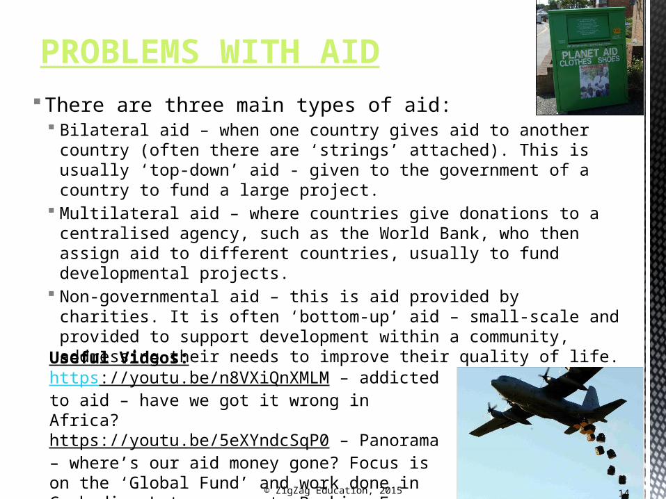
There are three main types of aid: Bilateral aid – when one country gives aid to another country (often there
are ‘strings’ attached). This is usually ‘top-down’ aid - given to the government of a country to fund a large project.
Multilateral aid – where countries give donations to a centralised agency, such as the World Bank, who then assign aid to different countries, usually to fund developmental projects.
Non-governmental aid – this is aid provided by charities. It is often ‘bottom-up’ aid – small-scale and provided to support development within a community, addressing their needs to improve their quality of life.
PROBLEMS WITH AID
Useful Videos:https://youtu.be/n8VXiQnXMLM – addicted to aid – have we got it wrong in Africa?https://youtu.be/5eXYndcSqP0 – Panorama – where’s our aid money gone? Focus is on the ‘Global Fund’ and work done in Cambodia. Later moves to Burkina Faso and looks at a company providing poorly treated mosquito nets.
14

15
Aid For many, aid is seen as the best way
to help LEDCs improve their quality of life. It helps to reduce suffering. However, there are many who question whether continually giving LEDCs aid really leads to development.
Many NGOs believe that aid, giving handouts, prevents countries from developing. They become aid-reliant, e.g. Haiti, whose own farming system has declined as it relies on food aid.
In contrast, if aid involves training people at the grassroots level how to use and maintain things, and items that are donated are appropriate technology, a better quality of life and local development will occur.
TRADE VERSUS AIDUsing a drip watering kit that was supplied by the Self-Help Development initiative that is supported by AusAID.
© ZigZag Education, 2015
16
Trade1. For others, the best way to stimulate growth and development in a country is
not by giving aid, but by improving trade. As with aid, there are different types of trade, and some are more useful than others.
2. The WTO and IMF both believe that trade liberalisation (free trade) is the way to help countries. It removes trade barriers, therefore making trade ‘free’. Unfortunately, trade liberalisation opens markets up to more competition, so a market crash is more likely to affect the sellers badly. MEDCs don’t practise free trade and, therefore, benefit from the free trade policy of the LEDC while stopping the LEDC importing certain goods into their country. It is usually manufactured goods which MEDCs put import taxes on, thereby discouraging LEDCs from moving from a farming-dominated economy to a manufacturing one, which is needed for development to occur.
3. In contrast, Fair Trade is seen by many as the way to help LEDCs trade their way out of poverty. Farmers are paid a guaranteed price for their products This gives local communities more disposable income which they are encouraged to invest in the local area, improving sanitation and education access, allowing more children to go to school and raising living standards
TRADE VERSUS AID

© ZigZag Education, 2015 17
MILLENNIUM DEVELOPMENT GOALS
The Millennium Development Goals (MDG) are a set of eight goals, each goal consisting of one or more measurable targets.
They were drawn up during the Millennium Summit in 2000. These goals were adopted by all of 191 UN member states. The MDGs aim to cover a range of different development issues, setting
out to deal with global security, environmental issues, human rights and poverty.
The MDGs were set up to achieve the following:
1. Eradicate extreme poverty and hunger
2. Achieve universal primary education
3. Promote gender equality and empower women
4. Reduce child mortality
5. Improve maternal health
6. Combat HIV/Aids, malaria and other diseases
7. Ensure environmental sustainability
8. Develop global partnership for development

© ZigZag Education, 2015 18
https://youtu.be/A5giOGjj5X8 – overview of how we’ve done on the goals
https://youtu.be/V7jgdVsoj18 – report into Kenya and MDGs; NB this is a government report and appears biased. It is also outdated – published in 2009, but great overview on Kenya’s geography.
MDGS

19
http://www.cgdev.org/page/mdg-progress-index-gauging-country-level-achievements

© ZigZag Education, 2015 20
This is a non-governmental organisation which was set up in 1989. It aims to bring health-care to people in remote areas within Africa by
ensuring that any vehicles they have access to are properly maintained and health-care workers are able to use them effectively.
They work with local communities, supporting them in extending and developing their health-care provision.
Due to poor road infrastructure and inhospitable terrain and climate, rural populations can be difficult to reach by health-care workers and this leads to a high infant mortality rate and maternal mortality rate.
Donations of insecticide-treated malaria nets are of little use if there is no method of getting them out to the rural regions they are needed in – this is where the Riders programme is so helpful.
None of the MDGs mention transportation improvements, but without them, it is difficult to improve health in a country such as Kenya, where 76% of its population live in rural areas.
RIDERS FOR HEALTH