Background.doc.5 SUSTAINABLE FOREST MANAGEMENT IN MALAYSIA …
31
66 Background.doc.5 SUSTAINABLE FOREST MANAGEMENT IN MALAYSIA - GUIDELINES FOR CONFLICT RESOLUTION S. Sothi Rachagan 1 “What of thee I dig out, let that quickly grow over, let me not hit thy vitals, or thy heart”. Hymn to the Earth, Atharva Veda A. INTRODUCTION The Malaysian forest is a biotic community which stirs the human imagination, and understandably so. It is one of the most dramatic and awesome biological systems on earth. The outstanding feature of the biotic community in the Malaysian forest is its richness and diversity which is brought about by biogeographic, ecological and evolutionary factors (Refer Table 1 for a classification of Malaysian forest ecosystems). In almost every major plant and animal group, there are more species than in temperate forests (Southwick, 1976:349). The variety of flora and fauna function in an intricate symbiosis projecting an image of continuous vitality, variety, resilience and abundance. Since early times the Malaysian forest played a significant role in man’s relationship with his environment. Technologically inferior societies with superior values of man-environment relationships evolved a cautious, caring and even revering relationship with the forests. Timber, fruits, bark, cane and other produce were extracted; game was hunted; the land was cleared for agriculture; solace and wilderness sought; the aesthetic traits appreciated and the innumerable spirits of the forests appeased. Where potentially harmful practices existed as in swidden agriculture, small population numbers with comparatively low or subsistent standards of living ensured that the forests’ intricate balance was unharmed. There existed an ecologically sound balance between the forests’ extractive, protective, recreational and aesthetic functions. The advent of modernised development with its emphasis on the extractive industries, the extension of cultivated land and the clearing for a host of economic activities has seen the rapid dwindling of the extent of these forests. A hundred years ago almost all of Malaysia was covered by forest. Barlow (1978) estimates that in 1876 as little as 2 percent of the forest had been cleared. Then at the turn of the century rubber was introduced and its rapid expansion led to significant loss in forest land in the west coast states of Peninsular Malaysia. Even then, at the time of independence in 1957, at least 85 percent of Peninsular Malaysia was still covered in forest, (Ooi, 1978). Since 1960, the pace of clearing has reached alarming rates. The balance has been shifted to enhance the short term extractive function thereby sacrificing the crucial protective, recreational and aesthetic functions. Conflicts between the different uses and users of the forest have become more frequent. This paper traces the alarming pace of forest clearance in Malaysia during the past 35 years and highlights the nature and extent of the damage caused in the process. It then examines the legal regime for management of the forest (general laws and measures, and governance structures). The paper finally, by way of case studies, identifies the conflicts that arise with the use of the forest and the conflict resolution mechanisms that have been, and can be used, by disputants to forest resources. 1 Professor, University of Malaya
Transcript of Background.doc.5 SUSTAINABLE FOREST MANAGEMENT IN MALAYSIA …

66
Background.doc.5
SUSTAINABLE FOREST MANAGEMENT IN MALAYSIA -GUIDELINES FOR CONFLICT RESOLUTION
S. Sothi Rachagan1
“What of thee I dig out, let that quickly grow over, let me not hit thy vitals, or thy heart”.
Hymn to the Earth, Atharva Veda
A. INTRODUCTION The Malaysian forest is a biotic community which stirs the human imagination, and
understandably so. It is one of the most dramatic and awesome biological systems on earth. Theoutstanding feature of the biotic community in the Malaysian forest is its richness and diversitywhich is brought about by biogeographic, ecological and evolutionary factors (Refer Table 1 for aclassification of Malaysian forest ecosystems). In almost every major plant and animal group, thereare more species than in temperate forests (Southwick, 1976:349). The variety of flora and faunafunction in an intricate symbiosis projecting an image of continuous vitality, variety, resilience andabundance.
Since early times the Malaysian forest played a significant role in man’s relationship with hisenvironment. Technologically inferior societies with superior values of man-environmentrelationships evolved a cautious, caring and even revering relationship with the forests. Timber,fruits, bark, cane and other produce were extracted; game was hunted; the land was cleared foragriculture; solace and wilderness sought; the aesthetic traits appreciated and the innumerable spiritsof the forests appeased. Where potentially harmful practices existed as in swidden agriculture, smallpopulation numbers with comparatively low or subsistent standards of living ensured that theforests’ intricate balance was unharmed. There existed an ecologically sound balance between theforests’ extractive, protective, recreational and aesthetic functions.
The advent of modernised development with its emphasis on the extractive industries, theextension of cultivated land and the clearing for a host of economic activities has seen the rapiddwindling of the extent of these forests. A hundred years ago almost all of Malaysia was coveredby forest. Barlow (1978) estimates that in 1876 as little as 2 percent of the forest had been cleared.Then at the turn of the century rubber was introduced and its rapid expansion led to significant lossin forest land in the west coast states of Peninsular Malaysia. Even then, at the time of independencein 1957, at least 85 percent of Peninsular Malaysia was still covered in forest, (Ooi, 1978). Since1960, the pace of clearing has reached alarming rates. The balance has been shifted to enhance theshort term extractive function thereby sacrificing the crucial protective, recreational and aestheticfunctions. Conflicts between the different uses and users of the forest have become more frequent.
This paper traces the alarming pace of forest clearance in Malaysia during the past 35 yearsand highlights the nature and extent of the damage caused in the process. It then examines the legalregime for management of the forest (general laws and measures, and governance structures). Thepaper finally, by way of case studies, identifies the conflicts that arise with the use of the forest andthe conflict resolution mechanisms that have been, and can be used, by disputants to forest resources.
1 Professor, University of Malaya

67
TABLE 1 Forest Ecosystems in Malaysia
I. Terrestrial/Dryland Forest
1. Lowland Dipterocarp Forest (LDF on alluvial terraces2. Hill Dipterocarp Forest (HDF)3. Mixed Dipterocarp Forest (MDF)*4. Upper Dipterocarp Forest (UDF)5. Montane Oak Forest (MOF)6. Montane Ericaceous Forest (MEF), including Subalpine Forest (SAF)7. Heath Forest (HF)8. Forest on Limestone (FOL)9. Forest in Ultrabasic Soil (FUS)10. Forest on Quartz Ridges (FQR)11. White Meranti-Gerutu Seasonal Forest12. Schima-bamboo Forest (SBF)
[Note: * There is no altitudinally recognised/categorised types of flora of Sabah andSarawak as the change of flora types is continuous with altitude. HDF is not arecognised category; upland forest dominated by dipterocarps in the emergentcanopy is termed MDF.]
II. Wetland Forest
II.A Freshwater/Riverine Forest1. Riparian Forest2. Freshwater Swamp3. Gelam Swamp Forest4. Peat Swamp Forest
II.B Estuarine/Coastal Forest1. Mangrove Swamp Forest2. Nipah Swamp3. Coastal Strand or Beach Forest
Source: Ministry of Science, Technology and the Environment, 1997:29The paper is presented under the following sub-headings:
A. IntroductionB. Loss of forested land
1. Land development for agricultural settlements2. The Timber Industry3. Environmental Impact of Jungle Clearing4. Construction of Dams5. Other Uses
C. Forest Management – Protection and Conservation1. Resource Base2. Resource Allocation3. Resource Management
a. Constitutional Imperativesb. Land Capability Classificationc. Land Codesd. Land Conservation Act 1960

68
e. Forestry Lawsf. Environmental Quality Act 1974 and EIA
D. Conflicts Over Forest Use and their Resolution1. Federal-State Conflicts2. Conflicts over Preservation of National Parks and Game Reserves3. Conflicts over Logging4. Conflicts over Dam Construction
E. Conflict Resolution MechanismsF. Conclusion
B. LOSS OF FORESTED LAND1. Land Development for Agricultural Settlements
At the time of independence, Malay (sia) was well-known mainly as one of the world’s chiefrubber and tin producers. Pre-independence agricultural development however had evolved adualism of large capitalistic foreign-owned estates employing cheap imported labour and asmallholder and peasant sector characterised by uneconomic holdings, indebtedness and poverty.Equating rural poverty primarily with landlessness the government drastically cut back on privatesector participation in agricultural colonisation and undertook public sector land settlement projects.The rationale behind this policy decision is simple. The post-independence government had nodesire to pursue, or even consider, a policy that would affect the structure and ownership of theplantations as was popular amongst other radical newly independent governments at that time. Itfelt that the country had adequate land resources to be developed and distributed to the landlesspeasants. This programme was considered as suitable for two other reasons: first, land could bedeveloped and alienated in blocks to groups of people thus avoiding the disadvantages of theprevious system of land alienation to individuals (i.e. administratively, land alienation throughresettlement was very acceptable); secondly, nucleated settlement villages were more convenient andamenable to upgrade the social and community status of the uprooted poor because it was mucheasier to provide social amenities such as schools, water, electricity, etc. in these settlements. A newauthority called FELDA was set up in 1956 to plan and implement the above resettlement objectives.
The first few years were difficult for FELDA. There was a lack of experienced personnel, theState Governments which had to first agree to alienate the land were slow to respond and theresponse from the target groups was wanting. However, from the mid sixties rapid progress wasmade. By the mid 1960’s there was a mania for land development in the country and a number ofagencies doing practically the same thing were created at both federal and state levels. Theinevitable result was competition in the rush for forested land for land development projects.
During the Second Malaya Plan (1961-1965), public sector participation totaled 216,000hectares. In the First Malaysia Plan (1966-1970) period 131,600 hectares were cleared. The pace ofclearing was increased during the next decade. During the Second Malaysia Plan (1971-1975),323,607 hectares were developed. Development peaked with a further 422,404 hectares in the ThirdMalaysia Plan period (1976-1980). Land clearing for agricultural development continued over theensuing years. By 1995, the public sector land development for new agricultural settlements totaled1,957,186 hectares (see Table 2). During this period the private sector too continued to open up newland – at around 60,000 hectares for each development plan period and peaking at 123,090 hectaresduring the Sixth Malaysia Plan (1991-95). It is estimated that a total of 2.5 million hectares offorested land were opened for agriculture from 1960 to 1995.
2. The Timber IndustryThe rapid growth of the timber industry since independence has compounded the problems
associated with large scale forest clearing for land development. Between1960 and 1975 log production increased from 3.2 million tons to 10.8 million tons and sawn
timber from 791,700 tons to 2.6 million tons. Between 1965 and 1975, plywood and veneerproduction increased from 55.67 million m3 to 81.78 million m3 . By 1970, Malaysia achieved thedubious distinction of being the world’s largest exporter of tropical hardwood logs and sawnwood.Since then significant downstream development has occurred.

69
TABLE 2 New Land Development by Federal and State Agencies ________________________________________
Year Hectares
________________________________________
1961 – 65 216,0001966 – 70 131,6001971 – 75 323,6071976 – 80 422,4041981 – 85 335,7451986 – 90 360,4701991 – 95 167,360
________________________________________
Total 1,957,186________________________________________
Source: Five Year Plans, Malaysia No. 1 to No. 7
The forestry and timber sector is an important resource base for industrial development andthe number of sawmills and plywood factories have grown significantly. The wood-basedmanufacturing sector also provides immense employment opportunities. In 1996, the forestry sectorcontributed about RM 14.05 billion or 7.3% of the country’s total export earnings. State revenuefrom this sector aggregated around several billion ringgit in the form of timber concessions, royaltieson log production and silviculture and development cess. The forestry and timber sectors provideddirect employment opportunities to more than 150,000 people (Ministry of Science, Technology andthe Environment, 1998, 7).
The diversity of tropical hardwood flora existent in the tropical forests and the carelessnesswith which forestry was approached generated a host of ecologically unsound and economicallywasteful culture in forest. The standing stock of timber in the tropical forests varies according toforest type. In harvesting these forests, only a small fraction of the timber volume is removed. InMalaysia, only 30-40 per cent of the timber volume is actually harvested. From a stock of 7,500species of seed plants containing 2,900 tree species, there are about 1,680 species of timber trees inMalaysia. Of these only 400 species have commercial importance and less than 10 per cent arepreferentially harvested (Furtado, 1979:96). There is an obvious need for developing technology anduses for and marketing of a greater variety of timber species. This has been the focus from 1991(Seventh Malaysian Plan, 1996, 599).
In the past tremendous amounts of valuable timber were released and made available to theindustry at low cost. Rapid development of the timber industry and structural changes have resultedin large investments on the milling and processing of the timber and with it the concommittantincrease in demand for logs. During the period of expansion the state forest departments failed toproperly control the size of the timber industry consistent with the carrying capacity of the resourcebase. Until the late 1950s, the 300 metres contour was arbitrarily taken to separate the `lowland’forests from the `hill’ forests. The lowland forests, because of their richness in useful species, theiraccessibility, and their regeneration capacity, constituted the country’s productive forests. The rapidrate of forest clearance, however, has meant that some states are no longer able to provide sufficientlogs for each mill and in several states the timber industry as a whole is already facing inefficientoperation. The powerful timber lobby would not allow the conservationist to further starve it of logs.When lowland forests became scarce the industry managed to have the authorities re-demarcate theboundary between the `productive’ forests and the `hill’ forests from 300 metres to 1,000 metres.Future clearance would definitely push this boundary higher. Forests above 1,000 metres areassociated with terrain too steep to exploit, and if cleared would entail erosion hazards (MalayanForester, 1970).

70
3. Environmental Impact of Jungle ClearingA direct and obvious outcome of the rapid clearance of forest areas is soil erosion. Soil
erosion will immediately cause a loss of soil fertility and the break down of soil structure,consequently resulting in the impoverishment of the remaining soil. All this will have an adverseeffect on its capacity to support agricultural crops or the regeneration of the forest. Futureagricultural and forest productivity will therefore be reduced (Aiken & Moss, 1975).
In areas being developed for agriculture, there is often a protracted interval between clearingthe forest and planting the crop during which time soil erosion can be excessive. This is especiallyso now when agricultural colonization is being stretched into the marginal areas and upstream wherethe magnitude of disturbance to the environment is greater. Of special concern is the mode ofclearing adopted. Vast areas are clear felled, the saleable timber extracted and the rest removed byburning. The access roads are then built and the land leveled before planting takes place. The timespan between felling and planting takes months and in instances even years. The exposed land issubject to heavy erosion and denudation. This process is often aggravated by the capital intensivenature of the exercise. Heavy tractors, bull-dozers and trucks increase compacting of the soil. Whenthe land is not flat, as is the case of the later resettlement projects, the compacted top soil preventsthe rain water from percolating slowly into the ground. It has been suggested that since all the areasdeveloped for agriculture are devoted to tree crops, once the new vegetation gives cover, conditionswill be similar to the original state (Albrook, 1973). However, it has been observed that in theMalaysian virgin forest, the presence of several tree storeys, as well as dense undergrowth, results ina larger interception of precipitation than in a cultivated rubber (or oil-palm) plantation (Teoh, 1973).Be that as it may, the 2-3 years before the tree crops can be considered to be effective replacementwould, despite the planting of a cover crop, already have created damage.
Logging practices in Malaysia are generally carried out by a combination of crawler tractor-winch lorry or crawler tractor-wheel skidder. More than 90% of the logs extracted in Malaysia arecarried out by crawler tractors (Ministry of Science, Technology and the Environment, 1997, 66).Such harvesting practices, even if selective in nature, involve damage to very large extents of theforests. It is estimated that 50-70 per cent of the forest area is damaged while felling only 10 percent of the area under timber. The system of crawler tractors and winch lorry or wheel skidder wasdevised for the lowland areas. The locational shift in logging to the more mountainous areas hasmade it necessary to change the structure and methods of the logging industry. A study done by theLogging Training Centre, Trengganu, in Bukit Kesing (300-1960 feet above sea-level) indicated thaton steep hills approximately 5 per cent of the land is actually bulldozed or had its soils disturbed toallow for road building and skid trailing (Ellis, 1976).
The skidding of logs often gouges deep, trough-like furrows in the soil mantle, which are idealfor concentrating run-off and initiating deep gullies. There is a gentle deficiency of quantitativestudies of the effects of logging upon erosion in Malaysia. Burgess (1971) notes that gullies up to 4metres deep can be found on abandoned logging tracks. Peh (1980) and Brooks, Richards andSpencer (1993) record similarly devastating impacts. Studies in other parts of the worldquantitatively demonstrate the adverse effects more fully (Frederickson, 1963 and Lull & Reinhart,1963).
The most damaging factor in forest exploitation is undoubtedly the construction of a networkof roads and tracks. In Malaysia, the effects of logging road construction upon soil erosion are likelyto be more adverse than in many temperate areas on account of the deeply weathered profilesfrequently encountered (Salleh and Tang, 1972) and the climatic conditions in those areas wheretimber production is increasingly being concentrated. Roads are usually about 4 metres wide and arecommonly `daylighted’ with a clearing of vegetation within less than 20 metres on either side. Theextent of the road and track network in logging concessions varies according to the nature of theterrain and the stocking densities of exploitable trees. Surveys conducted in 10 concession areas inPeninsular Malaysia have shown that in difficult terrain (slopes
steeper than 31o), there are, on average 8.7 kilometres of roads and tracks per square kilometre(22.6 miles per square mile), in comparison with an average of 9.9 kilometres per square kilometre(25.6 miles per square mile) in medium terrain (slopes of 17-310) and 13 kilometres per squarekilometre (33.5 miles per square mile) in easy terrain (slopes of less than 170) (FAO, 1973). The
71
magnitude of the damage multiplies when in illegal extraction, which is not inconsiderable, a totalabandonment of healthy practices is made. The damage enhances soil erosion and flooding rendersthe habitat unsuitable for a great variety of forest dwelling animals and thereby causes the loss ofinvaluable genetic material.
Over the years the authorities have focussed on improving timber harvesting practices. ASelective Management System is being encouraged. Since 1993 helicopter logging has beenpractised in parts of Sarawak but even here a mix with conventional logging methods is employed.Only in Sabah is Reduced Impact Logging practised (Ministry of Science, Technology and theEnvironment, 1997, 66). There has also been increased monitoring of forest resources with the useof remote sensing and Geographical Information System (Seventh Malaysia Plan, 1996).
4. Construction of DamsAnother major cause for the loss of forest land in Malaysia is the construction of dams or
impounding reservoirs for hydroelectric power, water supply and for irrigation schemes. Tho(1991) estimates that the total area of forests flooded as a result of dams built in the country could bewell over 100,000 hectares and this does not include the Pergau dam and the now suspended Bakundam.
5. Other UsesDeforestation and degradation of the forest occurs not only with agricultural colonisation,
logging and dam construction but also with a host of other activities. Mining activities causeextensive damage and leave behind retention ponds and sand piles. Highway construction,aquaculture and pollution also take their toll. Shifting cultivation which though not very significantand declining in Peninsular Malaysia (Bernard and De Koninck, 1997), is one of the major causes offorest degradation in Sabah and Sarawak (Sham Sani, 1993, 31). Maranjan and Dimin (1989)estimate that about 28 percent of the total land area in Sarawak has been affected by shiftingcultivation, an estimate they derived at after analysing the 1985 Landstat imagery. It is conceivablethat a large area of Sabah is similarly affected.
C. FOREST MANAGEMENT – PROTECTION AND CONSERVATIONIn the past, emphasis on economic development had relegated environmental issues to the
background. There was a tendency to ignore the concept of environmental stability. Emphasis wasplaced on immediate and measurable economic gains, a trend that has been common throughoutSouth-east Asia (Conway and Romm, 1973). Of recent, there is evidence of increasing official andpublic concern over environmental conservation. The Federal Government’s policy on environmentmatters was made explicit in the Third Malaysia Plan (1976-1980). In a chapter entitled`Development and Environment’, it was suggested that:
“It is vital that the objectives of development and environmental conservation bekept in balance, so that the benefits of development are not negated by the costs ofenvironmental damage”.
(Third Malaysia Plan, 1976:218)
A chapter on the Malaysian Environment has been included in the Fifth, Sixth and SeventhMalaysia Plans – an indication of the growing awareness and concern for the environment.
Increasing public concern over environmental matters is also evident from letters to thenewspapers and from the activities of a number of environment and conservation groups, many ofwhich are of relatively recent origin. The Malayan Nature Society has long advocated the need forconservation (Wyatt-Smith, J., 1961; Soepadmo and Singh, 1973). The Environmental ProtectionSociety of Malaysia and Friends of the Earth Malaysia (Sahabat Alam Malaysia) are now veryprominent. In recent years the consumers’ associations of the various states have also focussed onsustainable development. However most of these groups are urban-based. The settlers in the ruralFELDA schemes, and other rural population not directly affected in an adverse manner byecologically unsound development, have not expressed concern.
72
The local groups have been greatly assisted by the presence in the country of the World WideFund for Nature, Malaysia (WWFM) and the Wetlands International Asia-Pacific, both of whichably combine scientific research and expertise with networking and advocacy.
It is evident that the Malaysian forest needs to be managed so as to generate the maximumsustainable returns for economic growth of the nation cognizant always of the crucial protective,recreational and aesthetic functions it discharges. A policy that accommodates and balances theconflicting objectives in forest management needs to be implemented. Malaysia’s efforts atsustained viability can be reviewed by focussing attention on three major areas;
(1) Resource Base(2) Resource Allocation and(3) Resource Management
(1) Resource BaseThe first National Forest Inventory in Malaysia was conducted in 1962. The exercise was
repeated between 1970 to 1972 using aerial photography techniques of scale 1:25,000, and updatedin 1981 and 1982 using 1:40,000 aerial photographs. Another inventory using GIS techniques ofPeninsular Malaysian forest is currently underway (Seventh Malaysia Plan, 1996, 599). Malaysiastill has large areas under forest. Approximately 18.91 million hectares or about 57.5 percent of thetotal land is forested. (Refer Tables 3 and 4). The bulk of the remaining unharvested primaryforest lies in the east coast states of Peninsular Malaysia (Pahang, Trengganu and Kelantan) and inthe East Malaysian states of Sabah and Sarawak.
The National Forest Inventories and the preceding Forest Resources Reconnaissance Surveyprovided data for macro-planning of the timber industry in Malaysia. Forest resources appraisalsaimed at providing data for the formulation of forest land use and management plans on a ForestManagement Unit basis were then undertaken. Also completed is an inventory of disturbed forestswhich was done to obtain data for forest regeneration and development purposes.
The forest in Malaysia is comprised mainly of lowland and hill dipterocarp. There are alsoextensive areas of peat swamps and mangroves, and less extensive areas of freshwater swamps,highland forest and special communities such as those found on limestone, quartz and ultrabasicrocks, calcerous soils and others (Table 1).
Though much inventory data is available of timber types, research into other aspects of theflora and fauna of the Malaysian tropical forest is still at its infancy (Furtado, 1979, 88). The floraand fauna of Malaysia is exceedingly rich. It is conservatively estimated that the Malaysian forestscontain about 15,000 species of named flowering plants (9% of the world’s total), and more than1,000 species of ferns and fern allies. Many of these are unique and are found nowhere else in theworld (Ministry of Science, Technology and the Environment, 1998, 2). There is also a greatvariety of fauna in the country. In the vertebrates, there are about 300 species of wild mammals,700-750 species of birds, 350 species of reptiles, 165 species of amphibians and more than 300species of freshwater fish. A conservative estimate is that there are more than 100,000 species ofinvertebrates. These include about 1,200 species of butterflies and 12,000 species of moths. Littleis known of other groups (Ministry of Science, Technology and the Environment, 1998, 3). Themicroorganisms are very poorly known .
The economic importance of the inventoried trees, the growth increment of particular species,indeed, the full range and potential of the flora and fauna of the tropical forest still waits to bediscovered. Lowry (1971) for instance contends that the tropical moist forests of South-east Asiacontain plant species producing secondary metabolites such as insecticides, colouring matter,essential oils, drugs and medicine, saponins and base compounds which can be modified. Thesehowever have not been surveyed fully. Furtado (1979) concludes that the genetic status andpotential of a moist forest flora are poorly known thus calling for comprehensive botanical surveys.

73
TABLE 3 Extent of forest cover in Malaysia in 1997 (million hectares)
Peninsular Sabah Sarawak TOTAL Malaysia
_______________________________________________________________________
PFE 4.68 3.60 6.00 41.28* Productive 2.78 3.07 5.00 10.85* Protection 1.90 0.53 1.00 2.12
National and 0.74 0.38 1.00 2.12Wildlife Parks
Stateland Forest 0.43 0.47 1.61 2.51_______________________________________________________________________
TOTAL 5.85 4.45 8.61 18.91_______________________________________________________________________
Total Land Area = 32.86 million hectares
Source: Ministry of Science, Technology and the Environment, 1998, 8.
TABLE 4 Distribution and extent of the major forest types in Malaysia in 1997 (million hectares)
_______________________________________________________________________
Peninsular Sabah Sarawak TOTAL Malaysia
Land Area 13.16 7.37 12.33 32.86
Dipterocarp 5.38 3.83 7.20 16.41
Swamp 0.30 0.19 1.20 1.69
Mangrove 0.10 0.32 0.20 0.62
Total Forested 5.85 4.45 8.61 18.91 Land
Percentage of 44.5 60.4 69.8 57.5Forested Land
_______________________________________________________________________
Source: Ministry of Science, Technology and the Environment, 1998, 9.

74
Amongst the fauna only a few groups such as the birds, mammals, snakes and fishes,economic insects and butterflies are well known whilst the invertebrates are generally poorly known.
An area where the potential of the forest is realised is its contribution to water quality.Clearing the forests will bring the attendant problems of too little, too much and too dirty water –drought, floods and pollution. However important data has to be generated by way of identificationand mapping of `partial-source’ areas of all river basins in the country since these areas areessentially the critical sources of run-off in river systems. Most of these areas are adjacent to watercourses, in floodplains and acquifer-like depressions and it is important that they be conserved as faras possible. It is also necessary that the dynamic parts of the run-off generation areas at presentunder natural forest vegetation in the headwater regions be identified so that they may be preservedfor the sole purpose of generating a sustainable clean water yield. Upland forested areas have to beearmarked for reservoirs and identified as critical upland drainage basins (Low and Peh, 1982). Thewater supply shortages which plagued parts of the country in 1997 and 1998 have caused a greaterappreciation of this aspect.
Many of the structures and processes that operate and the vast potential of the forests’resource base is little known. Unless a greater appreciation of the forest’s potential exists, abalanced management policy will not eventuate.
(2) Resource AllocationTo view the tropical rain forest as a renewable resource has probably been its greatest curse.
Indeed what is clear is the incapacity of the rain forest throughout most of its extent to regenerateunder present land-use practices (Gomez-Pompa et al, 1972). Even if regeneration is possible, thenature and type of regeneration that will evolve will be suitable only for a limited number of thefunctions that undisturbed tropical forest currently play. The magnitude of disturbance betweenclearing and regeneration may be similarly unacceptable. Hence it is crucial that in the allocation offorests for their many competing demands sufficient stands of undisturbed permanent forests areestablished.
Prior to 1972, forestry in Malaysia was guided by the Interim National Forest Policy. Withthe establishment of the National Forestry Council in 1972, a National Forestry Policy wasformulated and accepted by the Council in August 1977. In 1978, the Council approved the settingup of the Permanent Forest Estate (PFE) amounting to 12.73 million hectares at that time but nowenlarged to 14.28 million hectares. The PFE is a term for the sum of forest reserves, areasmaintained or managed for their economic, social and ecological benefits. There are four categorieswithin the PFE:
(1) Protection Forests aimed at sound climatic and physical condition of the country, soilfertility and environmental quality, and minimization of damage by floods and erosion torivers and agricultural land,
(2) Production forests intended to ensure supply in perpetuity of forest produce, principallytimber for domestic purposes and export earning,
(3) Amenity forests for recreation, and protection of the country’s flora and fauna, and(4) Education and Research Forests
The National Forestry Department which implements the National Forestry Policy estimatedeven in the inception year of the policy in 1978 that much of the Permanent Forest Estate will begiven over to productive forests (Mohd Darus, 1978). This has proven to be so. Between 1978 and1994, approximately 1.4 million hectares of PFEs (mostly lowland forest) were degazetted. Theseareas do not include the large areas of converted stateland forests, estimates for which are notavailable. The National Forestry Act 1984 (sections 10-14) stipulates the need for equalreplacement of every hectare of degazetted PFE. Unfortunately there is no mention ofcompensating with forest land of equal or greater quality. As of 1994, despite pledges to gazette186,341 hectares of PFEs, seven state governments had failed to fulfill their pledge (Ministry ofScience, Technology and the Environment, 1997, 64). The total area under forest in Malaysiapresently is estimated to be 18.91 million hectares or 57.5 percent of the total land area (Table 3).Of this 14.28 million hectares are designated as Permanent Forest Estate. However only 2.12

75
million hectares of this are protection forests whilst 10.85 million hectares are productive forest andhence will be logged and foraged for rattan, medicine, oil and flavour, and wild plants (Ministry ofScience, Technology and the Environment, 1998, 8).
There are also a total of 2.12 million hectares of National and Wildlife Parks and 2.51 millionhectares of State Land Forest. The latter will no doubt also be the subject of logging concessions.The allocation has paid little emphasis to the protective role of the forests and the costs that will beincurred by the nation will indeed be high. Moreover, the specific areas for the four categories offorests are not yet all demarcated. It would be opportune that this be attended to urgently. But aswill be discussed later, there are peculiar aspects of Malaysian forest management that make thisdifficult.
(3) Resource ManagementThe unsatisfactory management of the forests in Malaysia is largely linked to the manner in
which the resource base is structurally organised.
(a) Constitutional ImperativesThe constitutional provisions pertaining to the separation of powers in the Malaysian
federation are governed by Part VI of the Federal Constitution. Article 74 defines the extent of thelegislative powers of the federal and state legislatures and does so by referring to three lists whichare set out in Schedule 9 of the Constitution - the Federal List, the State List, and the ConcurrentList. Any matters not included within these Lists, i.e. the residual powers, are regarded as statematters (Article 77). Parliament has legislative powers over matters in the Federal List and therespective State Legislative Assemblies have the powers of legislation over matters in the State List.Matters in the Concurrent List may be legislated on by both Parliament and the State LegislativeAssemblies but in the event of any inconsistency between a federal law and a state law, the federallaw prevails and the state law, to the extent of the inconsistency, is void (Article 75).
Land and forestry are enumerated in the State List and hence each of the 13 states isempowered to enact laws and formulate policy on land and forestry matters.
The Constitution provides for limited instances in which Parliament may, in spite of Schedule9, make laws in respect to matters on the State List:
(i) to implement international agreements;(ii) to promote uniformity of the laws of two or more States; or(iii) if requested to do so by a state legislative. (Article 76(1)(a),(b) and (c))
In relation to (i) above any such law made by Parliament shall not be with respect to Islamiclaw or customary law, and not without consulting the State Government concerned (Article 76(2)).In relation to (ii) and (iii) above any such law takes effect only when adopted by the StateLegislative Assembly, and then shall be deemed to be a state law and not a federal law, and mayaccordingly be amended or repealed by a law made by that Legislature (Article 76(3)).
In addition to these exceptions Parliament is empowered for the purpose of ensuringuniformity of law and policy, to make laws, inter alia, with respect to land matters including landtenure, landlord and tenant, and compulsory acquisition. In this case the law does not have to beapproved by the state legislatures (Article 76(4)), unless such law seeks to confer executive poweron the federation, and remains a federal law (Article 80(3)).
The Federal Government may exercise federal laws in particular areas of states even inrelation to matters listed in the State List by two other means. First, it may do so by acquiring StateLand compulsorily in the national interest for federal purposes (Article 83). Secondly, it may do soby proclaiming a development area for the purpose of implementing a development plan in thenational interest(Article 92(1)). A “development plan” means a plan for the development,improvement or conservation of the natural resources of a development area, the exploitation ofsuch resources, or the increase of means of employment in the area (emphasis added)(Article 92(4)).
A development area proclamation gives Parliament the power to legislate in pursuance of thedevelopment plan even on matters which are by virtue of Schedule 9 wholly within the legislative
76
competence of the state assemblies. This power has not so far been exercised and its potential forconservation not realised.
In relation to land (as in the case of local government) the Constitution recognises the need foruniformity between the States and co-operation between the Federation and the States. It providesfor a National Land Council (NLC). The NLC consists of a Minister as Chairman, not more thanten representatives appointed by the Federal Government, and a representative of each of the Statesappointed by the Head of that State. The function of the NLC is to formulate, in consultation withthe Federal Government, the State Governments and the National Finance Council, a national policyfor the promotion and control of the utilization of land for mining, agriculture, forestry or any otherpurpose, and for the administration of laws relating to these subjects, and the Federal and StateGovernments are obliged to follow the policy so formulated. The NLC may also be consulted bythe Federal or State Governments in relation to any land matter and must give advice thereon(Articles 91-94).
The East Malaysian states of Sabah and Sarawak (who in 1963 together with the 11 states ofthe former Federation of Malaya became Malaysia) have additional “safeguards” to protect theirspecial constitutional position. Amongst these safeguards is that Parliament’s powers to legislatewith respect to land do not apply to Sabah and Sarawak and these two states retain exclusivelegislative competence over land (Article 95D). Both states are represented in the National LandCouncil but their representatives may not vote and they are not obliged to follow any policy laiddown by the Council. This position may be altered by Parliament only with the concurrence of therespective State Government. Also, no area in Sabah and Sarawak may be declared a developmentarea without the consent of the State Government (Article 95E).
The cons titutional imperatives thus far described have resulted in a curious mix of uniformand fragmented laws in relation to land and forestry. (Refer Table 5 for Laws Related to ForestConservation in Malaysia). Some of these are described below.
TABLE 5 Laws Related to Forest Conservation in Malaysia
Peninsular MalaysiaNational Land Code 1965Land Conservation Act 1960National Forestry Act 1984Protection of Wildlife Act 1972National Parks Act 1980Water Enactment 1920Plant Quarantine Act 1976Environment Quality Act 1974
Sabah
Land Ordinance 1956Forest Enactment 1968Fauna Conservation Ordinance 1963Parks Enactment 1984
Sarawak
Land Code 1957 (Chapter 81)Forest Ordinance 1954 (Chapter 126)National Resources and Environment Ordinance 1949 (Chapter 84)Wildlife Protection Ordinance 1990National Parks and Reserves Ordinance 1956Public Parks and Greens Ordinance 1993

77
(b) Land Capability ClassificationBetween 1963 and 1976 a Land Capability Classification, similar in all the states of the
Federation was introduced. The Land Capability Classification divides land use into five categoriesbased on its potential productivity and economic yield:
• mining;
• agriculture with a wide range of crops possible;
• agriculture with a restricted range of crops possible;
• forestry; and
• conservation.
This five-fold classification is in a declining order of priority. Since its implementation therehave been major land use changes that have been financially rewarding but compromisedbiodiversity and conservation issues. (Ministry of Science, Technology and the Environment, 1998,6).
(c) Land CodesLand laws and administration in Malaysia are governed by the National Land Code 1965
which applies to the Peninsular Malaysian states of the Federation except Penang and Malacca,both of which are governed by the National Land Code (Penang and Malacca Titles) Act 1963; theSabah Land Ordinance 1956 (Cap 68) and the Sarawak Land Code 1957(Cap 81) which apply toSabah and Sarawak respectively. Even the National Land Code, though a federal law made underArticle 76(3) of the Constitution, did not seek to assume executive powers. Each of the statestherefore, are competent and do administer land law in their respective states.
The National Land Code 1965, the Sabah Land Ordinance (Cap 68) and the Sarawak LandCode (Cap 81) do not provide for biodiversity or conservation uses of the land. Land is categorisedon the basis of intended “uses” – agriculture, building and industry. Land law in Malaysia is thusgeared to “use of land” for economic purposes rather than biodiversity maintenance andconservation. Unalienated land can serve these latter purposes but is dependent upon the decision ofthe 13 individual states for their continued non-alienation.
(d) Land Conservation Act 1960The Land Conservation Act 1960 (Revised 1989), is a federal law made under Article 76(3) of
the Constitution and was in the same year adopted by all the 11 Peninsular Malaysian states, but notby Sabah and Sarawak. The Act permits steep land that may be susceptible to erosion to be gazettedas “hill lands” where the clearing of vegetation (s. 6(1)) or the planting of short-term crops (s.5) isprohibited unless a permit is obtained. The Act would be a useful tool for protecting forests in steepland but few, if any, areas have been gazetted as hill lands. Enforcement of the Act is theresponsibility of the Land Administrator or Collectors of Land Revenue (i.e. District Officers), whogenerally have little or no training in soil conservation. The Department of Agriculture and theDrainage and Irrigation Department which would be more capable of enforcing the Act areunfortunately not given any executive authority to enforce it.
(e) Forestry LawsAs noted earlier, the constitutional provisions also ensure state autonomy over forestry.
Consequently, each of the 13 states is empowered to enact laws and formulate policy on forestrymatters. The State Forestry Departments are responsible for the administration and management ofthe states forest resources, forest industries development and forest law enforcement.
Until 1984, the various states had their own forestry enactments, which were based on theStraits Settlements Ordinance 1908 (No. 22 of 1908) and the Federated Malay States ForestsEnactment 1914 (No. 18 of 1914). These were primarily concerned with the removal of forestproduce including timber and revenue collection. There were provisions enabling the state forestry

78
departments to specify conditions along with the licenses they issued, but this power was seldomexercised for conservation or sound logging practices.
In 1984, a federal law titled National Forestry Act 1984 was enacted under Article 76(1)(b) ofthe Federal Constitution and adopted by the 11 Peninsular Malaysian states in 1985 and 1986. Thestates of Sabah and Sarawak did not adopt the Act and in these states the operative law are theSabah Forest Enactment 1984 and the Sarawak Forest Ordinance 1954. Even in PeninsularMalaysia, despite the adoption of the National Forestry Act 1984 by each of the states, they continueto be autonomous in forest management. The Federal Forestry Department which is under theMinistry of Primary Industries, is therefore reduced to a mere advisory capacity without muchinfluence on the management of the resources. The federal agency’s functions are confined toplanning, research and development and the provision of technical advice, services and facilities fortraining. It is consequently difficult to synchronize the management of the forests between thevarious states.
(f) Environmental Quality Act 1974 and Environmental Impact Assessment (EIA)Undoubtedly the most significant piece of legislation pertaining to the environment is the
Environmental Quality Act 1974, a federal law to provide the legal framework for a co-ordinatedenvironmental management programme. The Act provided for a new agency at the federal level,the Department of Environment (DOE) within the then newly formed Ministry of Science,Technology and the Environment. The early emphasis of the Ministry in exercising its powers wasto reduce pollution by focussing on particular polluting industries.
The requirement for Environmental Impact Assessments (EIA) was not a part of the Actintroduced in 1974. EIAs were first introduced in 1980 for three large projects, including theKenyir Dam Project in Ulu Trengganu even before the establishment of the EIA Unit in the DOE.Over the next six years at least 39 projects were subject to EIA studies (Fifth Malaysia Plan, 1986-1990, 280). Then in 1985, the EQA 1974 was amended to insert a new section 34A making EIAmandatory. This was followed by the EIA Order 1987 which came into force on 1 April 1988. EIAare now mandatory for 19 prescribed activities many of which are important for sustainable forestuse (Refer Appendix I).
The DOE has over the years issued guidelines for preparing EIA Reports for different types ofactivities, including:• Guidelines for the Prevention of Soil Erosion and Siltation;• Guidelines for Environmentally Sensitive Areas in Malaysia;• Guidelines for Development of Tourist and Recreational Facilities in National Parks.
Guidelines for forestry are currently being prepared.
D. CONFLICTS OVER FOREST USE AND THEIR RESOLUTION1. Federal-State Conflicts
The mismanagement of the forests by the separate states is in part due to the financial positionof these states. The constitutional allocation of powers and duties to the states is far in excess ofwhat their revenue sources can usefully sustain (Malaysian Constitution, Tenth Schedule; AbdullahAyub, 1974.). The constitution also bars the states from raising loans without federal governmentconsent. Constitutional and extra-constitutional grants help make up for the deficits faced by thestates but clearly the greater the dependence of the states on central government aid via non-guaranteed grants, the less tenuous their autonomy. States have therefor sought to overcome theirfinancial constraints by exploiting their resource base. Since forest revenue principally in the formof royalty and premium, accrue to the states, the forest policy of the states is one of rapidexploitation (Rachagan, 1981). This has been the situation since the early years of independenceand is illustrated by the following example from Kelantan state.
The 1959 elections led to the federal government and the state government of Kelantan, beingcontrolled by the Alliance Party (now enlarged into the Barisan Nasional or BN) and the PanMalayan Islamic Party (PAS) respectively. Campaign promises of the Alliance had assured thepeople that an Alliance state government would cause the construction of the Sultan Yahya PutraBridge across Kelantan River. Political prestige compelled the PAS state government to undertaketo build the bridge. Short of finances, starved of any extra-constitutional assistance from the

79
Alliance controlled federal government, and constitutionally restrained from any borrowing, thePAS state government evolved a novel plan to finance the bridge. A concession of prime forestedland was given for timber extraction to a private company, the Timbermine Industrial CorporationLimited, obtaining in return an advance payment of royalties amounting to RM2.5 million. TheCorporation was required to pay royalty for the timber extracted but 50 per cent of the royaltypayable was to be held back by the Corporation until the prepaid RM2.5 million was realised orrefunded by the state government. The Federal Government’s attempt to challenge theconstitutionality of the arrangement on the grounds that the transaction was indeed borrowing wasnot upheld by the courts (Government of Malaysia v Government of the State of Kelantan [1968] 1MLJ 129). The Federal government’s position has since been imposed by way of a constitutionalamendment (Constitution (Amendment) No. 2) Act 1971, s.8). The power of the states to alienateforest for timber is however not curtailed, and they continue to make ecologically unsound timberconcessions.
Sound management of the forests may be possible only if alternative sources of revenue forthe states are found and if these sources of revenue are made conditional on sound forestmanagement. Alternatively, the Federal Government will have to rely on the Constitutionalprovisions which:
• allow it to acquire state land for federal purposes (this will call for conservation to be acceptedby the courts as a legitimate federal purpose);
• Declare selected forest areas as development areas; or
• Use the powers of Parliament under Article 76 to make laws in respect of forest (basing itsactions on the ground that it is implementing international agreements on conservation, bio-diversity and sustainable development).
2. Conflicts over Preservation of Parks and ReservesNational parks are fundamental in that they are often out-standing natural areas representative
of the diversity of ecosystems which have been set aside so as to guarantee their protection and usefor present and future generations for scientific, educational and recreational use. They perpetuatein a natural state representative samples of physiographic regions, biotic communities and geneticresources and species in danger of extinction to provide ecological stability and diversity. Theyoffer substantial economic returns by promoting national and international tourism. Veryimportantly, the maintenance of national parks encompass intangible cultural values of greatsignificance which strongly influence the quality of life of people. National parks however involveland that is vied for by potential alternative users for purposes of timber extraction, agriculture andsettlement, mining, flooding for power generation and the like.
The amount of land currently dedicated to national parks comprises a small fraction of thetotal land area of the country (Refer Table 3 and Appendix 2). Forest degradation in even sodesignated areas is possible. In this the Endau-Rompin story is instructive.
The Endau-Rompin Forest Reserve consisting of 202,343 ha. of forested land embracing thesteep sandstone terrain of Gunong Besar and its neighbouring hills is situated on the borders ofPahang and Johore states From within the area flow five of the more important southern rivers andtheir importance to the water economy of southern Malaysia were amongst the principalconsiderations that led the Malaysian Government declaring in its Third Malaysia Plan (1976-1980_that it intended to turn the Endau-Rompin Reserve into a National Park. The proposal was basedon an informal agreement reached in 1972 between the State Government of Pahang and theFederal Government. Under the agreement a limited amount of logging was to be permitted inperipheral areas of the reserve but a core area of 36.421 hectares was to be left inviolate for all time.When the logging in the peripheral area was completed, the whole reserve was to be turned into anational park. Even as late 1976 H.H. The Sultan of Pahang held that “a group of 10-15 SumatranRhinoceros, the largest known group in the world was found recently in the Endau-Rompin area”and “in response to this the State Government is in the process of gazetting a game reserve to savethe species” (Rachagan, 1981).
Despite these pronouncements, the State Government of Pahang unilaterally set aside theunderstanding that had been reached and issued new logging licenses for exploitation of the core
80
area and destroyed what a joint front of scientific organisations led by the Malayan Nature Societytermed as the “latest comprehensive representation of the rich southern forest ecosystem”. A nationwide campaign and representations from the Federal Government, notwithstanding, the then PahangState Secretary declared that
the National Park would only be set up after the state had fully exploited its economicpotential and that “when it comes to choosing between human welfare and animal survival, the statehad to opt for the former”. The attitude of the State Secretary and the Pahang State Governmentreflects the dangerous tendency of equating what is clearly the selfish interest and welfare of a fewwith economic growth and with human welfare in general (Rachagan, 1981).
The Endau-Rompin affair is not the only instance of attempted and actual violation of nationalparks and game reserves. Environmentalists succeeded in causing the abandonment of the proposalto log the Pahang portion of Taman Negara in 1970 and in 1983, managed to foil the construction ofthe Tembeling Hydro-electric Dam over parts of the same park. Part of the Trengganu portion ofTaman Negara has already been innundated by the Kenyir Dam. Sizeable portions of Templer Parkin Selangor have been relinquished to mining, building, construction and road building. Parts ofthe
Kinabalu National Park in Sabah have been exercised for development whilst yet other partshave been subject to deleterious effects of copper mining.. The seriousness that the stategovernments place on their declarations of national parks and game reserves is reflected in the fateof Klias in Sabah. Klias, was gazetted as a national park in 1978 and was degazetted as such in1981.
3. Conflicts over dam construction1. The rapid growth of Malaysia’s economy since independence, especially its shift to the
industrial and manufacturing sector, has led to increased demands for energy. An energy policy,termed the four-fuel policy, was introduced in 1979. The policy identifies four primary sources forenergy requirements – hydropower, coal, ore and gas – and proposes greater diversification ofenergy supplies from high dependence on crude oil and petroleum products. The long termobjective is to be self reliant for energy, and expand other sources of energy supply so as to releasemore petroleum for export. To an extent, this has been achieved.
Malaysia’s hydropower potential is considerable. However the share of hydropower as acommercial energy source has declined from 7.4 percent in 1985 to 4.4 percent in 1995 and thegovernment has periodically looked at ways of expanding hydropower supply (Seventh MalaysiaPlan, 1996).
Conservationists have raised concerns with regards large scale dam construction. Thecontroversy surrounding the abandoned plans to build a dam across the Tembeling River in Pahangand the now suspended Bakun Dam in Sarawak will serve to illustrate the conflicts that arise.
The Tembeling Hydro-electric ProjectThe proposal to build a dam in Taman Negara, namely, the Tembeling Hydro-electric Project
(THEP) was first mooted in October, 1971 when the National Electricity Board (NEB)recommended a multi-purpose dam across the Sungai Tembeling. The river is an upper tributary ofPeninsular Malaysia’s longest river, Sungai Pahang, in central Pahang. The proposal followed thecatastrophic floods of January, 1971 which claimed 24 lives and necessitated the evacuation of some150,000 people from their homes in the Pahang River Basin alone. Less severe but nonethelessmajor flooding occurred again towards the end of 1971. The need for flood mitigation and thehydro-electric power potential of the basin formed the principal considerations for the proposed dam(Rachagan, 1983).
The Tembeling Project estimated to cost in excess of RM300 million, would have consisted ofa main dam, saddle dams and associated works, including an intake feeding through a power tunnelto a conventional surface power station. With a total installed capacity of 110 megawatts, theaverage annual output of energy, it was estimated, would be 441 million kilowatt-hours. A gatedshaft spillway was provided for regulated flood discharges.
The main dam would have been a rockfill structure with a height of 67 metres (220 feet), andthe six saddle dams would have involved earthfill construction. Total volume of fill in the dam

81
would have been 2.5 million cubic metres (3.3 million cubic yards) and the reservoir formed by thedams would have spanned 53 kilometres (33 miles) having a surface area of 250 square kilometres(96 square miles) (NEB, 26th and 27th Annual Report).
Since the initial proposal by the NEB in October, 1971 the project was the subject of studiesby two teams of foreign experts - an Australian team was appointed in 1972 to undertake a study ofwater management and flood mitigation in the Pahang River Basin with special emphasis on thefeasibility of multi-purpose dams, and a Russian consulting group appointed in 1973 to undertake adetailed pre-investment study for a hydro-electric project on the upper Tembeling.
The Malaysian Department of Wildlife and National Parks made its own impact assessmentstudy and strongly opposed the project. On July 14, 1978 the NEB announced the indefiniteshelving of the Tembeling project. In January 1982, the then Malaysian Deputy Prime Ministerannounced the revival of the Tembeling Hydro-Electric Project. This generated a nation-widecampaign against the dam project. The principal reason for the public outcry was that the projectwould have flooded a significant part of Taman Negara, Malaysia’s oldest national park.
Taman Negara, covering an area of 1677 square miles was created from the 553 square milesGunung Tahan Game Reserve in Pahang State created in 1925, and, portions of Kelantan andTrengganu. It was constituted by a common enactment written at different times for the threeadjoining Malaysian states of Pahang (1939) Trengganu (1938) and Kelantan (1938) and dedicated“in perpetuity for the propogation, protection and preservation of the indigenous fauna and flora ofMalaya”. Despite the existence of other park areas in the country, Taman Negara remains the largestand most significant. Its land area exceeds the total extent of all the parks. Taman Negara isconsequently an essential feature of sound ecological management of Malaysia and any attempt toalter or modify it would have dire consequences.
Taman Negara has 3 major river valley systems. The most important of these is the SungaiTembeling followed by Sungai Atok and Sungai Lebir. The dam would have flooded the lowland ofSungai Tembeling and also affected the lowland area of Sungai Atok. It was estimated that an areaof 37.3 square miles within the park and 42.4 square miles outside the park would be inundated. Theinundated land would have comprised 13.5 percent of the 278.24 square miles of choice lowland ofthe park which is below 500 feet. The spread of the water however would have accentuated thedisruptive effect and resulted in radical modifications in the transfer and extirpation of vegetable andanimal species. The dam would have vastly reduced the already limited acreage of lowland forestsin the country and limited habitat diversity and special vegetation type in the park area. Theflooding would have disrupted the home range of more than 50 percent of the parks mammals – bothlarge and small.
The dam would have required about 5 million cubic metres of earth and rocks for theconstruction of the main and saddle dams, with the latter requiring six times the quantity of the maindam fill. The bulk of this material would most probably have come from within Taman Negara.More than 80 km of roads to the damsite and within Taman Negara would have had to beconstructed and heavily used during the construction period. The availability of large tracts ofcommercially valuable timber in the area would have resulted in many more kilometres of loggingroad. The damage would have enhanced soil erosion and flooding and rendered the habitatunsuitable for a great variety of forest dwelling animals in areas far greater than the damsite itself.
The human impact would have been just as devastating for it would have affected the wealthof folktales, legends, folk beliefs and medicines, folk songs, devices and games, traditionalhandicrafts and technologies found in the area. It would also have resulted in the displacement ofseveral Malay and Orang Asli villages – in all an estimated 8,000 people.
These adverse effects galvanised non-governmental organisations who joined efforts byforming a Tembeling Co-ordinating Committee to wage a co-ordinated nationwide campaign againstthe proposed dam. The campaigns included the sale of postcards, T-shirts, printed articles in thepress, a signature campaign and seminars on the controversial subject. The campaign lastedthroughout 1982 until the government announced the shelving of the Tembeling project on January16, 1983 saying that ecological considerations had been among the factors influencing the decision.

82
The Bakun Hydro-Electric ProjectThe bulk of Malaysia’s hydropower is located in Sarawak (69 percent) with 17 percent in
Sabah and the remaining 14 percent in Peninsular Malaysia (Ministry of Science, Technology andthe Environment, 1998, 16). Studies to utilise the hydropower of the Sarawak rivers began in the1970s and continued intermittently through the 1980s. The Rajang River was the focus of a studybegun in 1980. That study identified four possible dam sites – Bakun (2,400 MW), Murum (900MW), Pelagus (770 MW) and Baleh (900 MW). These projected capacities were far in excess ofSarawak’s own needs and hence the proposal to lay a 650 kilometre undersea cable to cross theSouth China Sea and carry part of the electricity to Peninsular Malaysia.
Bakun was finally the chosen site. It was originally proposed to be built in the 1980s. But thehuge cost, the recession of the mid-1980s and local protests led to an announcement by theGovernment that the project would not be undertaken. The Prime Minister, Dr. Mahathir Mohamedwas quoted as claiming that the scrapping of the project was proof of
Malaysia’s commitment to the environment (New Straits Times, June 13,1990). However, inSeptember 1993, the Federal Cabinet announced that the Bakun Dam Project would be resurrected.In January 1994, a Memorandum of Understanding (MOU) was signed which awarded the majorcontract for the dam to Ekran Bhd without any tender process. According to Ekran’s 1995 annualreport, Ekran Bhd was led by Sarawak timber and property tycoon Ting Pek King with a 21.11percent stake and his wife with a 5.19 percent stake. Much of the rest of Ekran’s shares were heldby nominee companies, meaning that it is impossible to identify who actually holds the shares.Insan (1996) suggests that the company is closely connected to senior politicians in the FederalGovernment and the Sarawak State Government who would reap monetary benefit from Bakun’sspin-offs.
The Bakun HEP, billed as the biggest hydroelectric power dam in Southeast Asia, is located 37km upstream of Belaga, on the Balui River. The reservoir built with a dam of 205 metres in height,billed as the highest in the world, would flood 69,640 hectares of forest. The supportinginfrastructure will make further inroads into the forest – an airport, 125 km road from Bintulu to thedam site, hostels and hotels, and a 10,000 hectares industrial park. The usage prior to this wassecondary forest (45.5 percent), shifting cultivation (15.6 percent) and already logged land (36.9percent). The whole of the land would no doubt, be logged to exhaustion prior to the dam’s flooding.Fifteen longhouses from the Kayan, Kenyah, Kajang, Ukit and Penan tribal communities would bedisplaced – in all 8, 188 people according to Ekran’s 1995 EIA report. In March 1995, the first offour EIAs was approved and work started on site-clearance, office construction, clearing of the landfor the airport, reservoir and tunnel construction. The affected communities and public interestNGOs mounted a campaign against it and Sahabat Alam Malaysia sponsored an action in the courtsby three of the affected natives. The project continued nonetheless. The economic crisis led thegovernment to defer the project in October 1997 but by then the land had been logged and theaffected communities relocated.
4. Conflicts Involving the Indigenous People of the ForestThe forest is not only the home of flora and fauna but also of humans – it is occupied by
indigenous communities who have evolved a rich and dynamic adat (custom) that orders theirrelationship with fellow men and the environment. Adat is an all-pervading system also involvinglegal rules and principles, which ensured access to land and forest to all members of the community.This traditional system is fast disintegrating from the impact of new laws and the process ofdevelopment imposed by the State and larger society. There has been a steady encroachment uponland rights and utilisation of these indigenous populations, who rely on the forest for their sustenanceand life. Even rights initially recognised by the state as inviolate can, and have, been extinguishedby changes to the law or by administrative fiat. Powerful forces conspire to rob these people of theirland and forest – for agricultural settlement, logging, dam construction and a host of other economicactivities – not in their interest but that of the project proponents and “larger society”. The resistanceoffered by these people and their lack of success in defending their rights are the most tragicconflicts that encroachment into forest land manifests.
In Peninsular Malaysia the most vulnerable are the Orang Asli communities. Orang Asli’ is ageneric term for three tribal groups – the Negritoes, the Senois and the Proto-Malays. Each of these

83
three tribal groups is further divided into 18 sub-groups based on ethno-linguistic criteria. As of July1, 1991 there were a total of 85,453 Orang Asli in 778 settlements spread over 47 districts in 9 statesof the Peninsular (Jimin, 1992, 10).
The Malaysian Constitution confers special privileges and protection on all indigenous peoplesof the country but denies this to the Orang Asli. Hence, unlike the Malays and the natives of Sabahand Sarawak (Article 153 and 161A) the Orang Asli do not enjoy any clearly defined and obligatoryprovision of special privileges and protection. However, a federal government intent on providingspecial benefits to the Orang Asli may introduce positive discrimination “for the protection, wellbeing or advancement of the aboriginal peoples of the Malay Peninsular (including the reservation ofland) or the reservation to the aborigines of a reasonable proportion of suitable positions in thepublic service (Malaysian Constitution, Article 8(5)(c)). This is an enabling provision the exerciseof which has not been ruled upon by the Courts as mandatory. It is a power that the FederalGovernment has yet to utilise to the benefit of the Orang Asli (Rachagan, 1990).
The Aboriginal Peoples Act 1954 (Revised, 1974) empowers the states to declare (and revoke)aboriginal areas and reserves and for this purpose to even compulsorily acquire non-state land. Thestates have not been active in this aspect and this despite the recommendations of the Jabatan OrangAsli (JOA), a federal government department established to provide for these marginalised anddisadvantaged people. Gomes (1990:24) citing the New Straits Times of January 16, 1983 notes:
In the State of Perak, for instance, only 306 hectares have been gazetted asaboriginal reserve and another 17,325 hectares have been approved but yet to begazetted while application for 25,000 hectares by the JOA to the state governmentis still awaiting a decision. It seems some applications were made as long as 25years ago.
This remains the situation in most of the nine states in which the Orang Asli reside.In Sarawak the pressure is on sections of the Dayak peoples. The term Dayak peoples refers to
a broad ethnic grouping which in 1991 numbered 810,149 and comprised some 49.35% ofSarawak’s population. They included Iban (29.45%), Bidayuh (8.28%), Melanau (5.71%), Kenyah(1.25%), Kayan (1.23%), Murut (0.79%) and other smaller groups (Department of StatisticsMalaysia, 1995, 79-83). Most of the Dayak communities practice shifting cultivation. Land andforest is their livelihood and their most cherished traditions and spiritual beliefs are centred on theirrelationships to the land. Apart from the agriculturists there are the forest people who depend to alarge extent on hunting and gathering activities for their livelihood. These groups include the Penan(9434), Ukit, Bukitan (Baketan) and Sian (Sihan) peoples. To them the forest is the only home(Hong, 1987). Rob them of their forest and they perish.
The Sarawak Land Code (Cap 81) (Revised Law of Sarawak 1958), which with amendmentsis the main legislation determining land tenure and administration in the state provides for nativearea land, native customary land and three other categories of land use - mixed zone, reserved,and interior area land. The Land Code and subsequent amendments provide little protection ofcustomary rights. The state authority is empowered to declare lands as native area land and nativecustomary land. It has also several clauses that enable the government to remove or extinguishthese rights.
Logging, dam construction and road building encroach into the lands of the Dayak people andtheir system has come under thread by various laws and policies. Their fight to protect their rightshas been ably chronicled by several writers ( Hong, 1987; Sahabat Alam Malaysia (1989), Chen,1990; Cleary and Eaton, 1992; Sutlive, 1992). The natives have organised themselves to exposetheir plight and on occasions resorted to direct action. In this they have been assisted by a numberof Malaysian non-governmental organisations. Unfortunately, law and the coercive authority of thestate backs those who would encroach on the land and forests of these people.
The Forests (Amendment) Ordinance 1987 of Sarawak is an example of this. In 1987 afterrepeated requests to the government for a cessation of logging in their land the Penans blockadedtimber concession areas and prevented the movement of logs, labour and supplies. Kayan, Kenyahand Kelabit groups also set up their own barricades. The operations of nine major timber companieswere drastically affected. When the Courts decided that the barricades built on their own land were

84
not breaking the law, the state government brought an amendment to the forestry law (Cleary andEaton, 1992:186-7). The amendment stated:
“Any person who
(a) lays, erects or sets up or causes to be laid, erected or set up any structure,stone, log, tree or any other article on any road constructed or maintainedby the holder of a license or permit issued under this Ordinance so as tocause a barrier or obstruction to the passage of that road; or
(b) wilfully prevents, obstructs or molests any forest officer or police officerin the execution of his duties or the holder of a license or permit or hisemployee or agent from removing the barrier or obstruction or in theexercise of his rights within the area covered by the license or permit;
shall be guilty of an offence: Penalty, imprisonment for two years and a fine of sixthousand dollars…”
(Forests (Amendment) Ordinance, 1987)
E. CONFLICT RESOLUTION MECHANISMSThe diminishing forests and their resources are disputed over by a variety of interests. More
significant amongst these are:
• The indigenous communities which have from time immemorial occupied these forests butwhose claims have been made tenous by land and forest laws;
• Individuals and corporations who have obtained permits from the state to extract forest produceor convert the forest to other uses;
• Individuals and non-governmental organisations which represent the interests of disadvantagedminorities and the collective interests of society for conservation and sustainable development;
• The governments of the 13 states of the Malaysian federation who have jurisdiction over theforests and their resources, and their agencies and
• The federal government and its agencies.
Conflicts occur amongst and between individuals, organisations and agencies within each ofthese interest groups. Indigenous communities rely on the rules of adat to resolve disputes amongstits members. Conflicts between the federal government and the states has been resolved at the levelof the National Land Council, the National Forestry Council and by negotiation between federal andstate leaders. The principal factors that have contributed to state leaders being generally compliantto the dictates of the federal government leaders are reliance on the federal government for extra –constitutional grants to their states and membership in the same political party. The need to rely onthe courts has arisen only when there has been a different political party in power at the state levelfrom that at the federal level. The dispute between the Federal Government and the Government ofthe State of Kelantan cited earlier is an instance of such. The Constitution provides that the FederalCourt, to the exclusion of any other court, shall have the jurisdiction to determine disputes asbetween the federation and the states (Article 128(1)).
Conflicts between the state and the interests granted permits to extract forest produce orconvert parts of the forest to other uses on the one hand, and the indigenous communities and NGOs,which have disputed such changes in land use on the other hand, have occurred with increasingfrequency over the years. Two conflict resolution mechanisms have been relied on to resolve thesedisputes – the courts and the EIA system which is now a statutory obligation for project proponentsin forest areas.
The Malaysian courts have shown a willingness to grant access to the judicial system forindigenous communities who have claims over forests. The problem however, is one of establishing

85
their claim – an invidious task for communities that lack land titles, mapped territories ordocumentation. Rules as to procedure and evidence are particularly problematic to these groups asis the denial of class action suits. A useful development occurred in the High Court of Borneo in thecase of Jok Jau Evong v Marabong Lumber Sdn Bhd ([1990] 2 CLJ 625). That case is of specialimportance to the issue of incursions by logging interests into native land in Sarawak. The plaintiffswere three members of the Kayan community in a remote Sarawak kampong. The Kayan had beengranted native land rights over an area of protected forest by the colonial government by aproclamation under the Forests Ordinance. In 1987, they found their land being logged by a timbercompany under a licence granted by the state government. They sought various declarations andinjunctions in a representative action brought on behalf of the Kayan community though about halfthe community disagreed with the proceedings. The High Court held that the plaintiffs could bringa representative action. This in itself is a major victory for these communities since land is heldcollectively. But this proved pyric in the light of the judges other rulings.
The defendant had not pleaded the defence of limitation but the judge nonetheless allowedthem to put the defence of limitation and then ruled that the Plaintiffs were time-barred: “If theplaintiffs sleep on their rights then they take the risks that their rights may be extinguished”. Thejudge could have ruled that the limitation period should run from when the plaintiffs were aware ofthe facts which would have led them to believe that their rights were being denied and of their rightto take action to protect them. That would have permitted the courts to determine the issue on themerits of the case. Instead the judge chose to adopt a highly restrictive view. It is unfortunate thatmembers of these communities are expected to peruse each Gazette notification to ensure that theirrights are not removed by administrative fiat and surrendered by the State Government to logginginterests.
Of great significance to the rights of indigenous peoples to their land is the High Court (JohorBahru) decision in Adong bin Kuwau & Ors v Kerajaan Johor & Anor ([1997] 1 MLJ 418-436).The case involved 52 plaintiffs who were heads of aboriginal families living around the SungaiLinggiu catchment area near Kota Tinggi, Johor, which had been acquired by the Government of theState of Johor for the construction of the Sungai Linggiu Dam. The plaintiffs contended that therights accorded to the aboriginal people by common law and statutory law were proprietary rightswithin the ambit of Article 13(1) of the Federal Constitution and that when these rights were takenaway, they should be compensated pursuant to Article 13(2). His Lordship Mokhtar Sidin JCAheld (at pp. 429-430; 436 of the judgment):
The British introduced the Torrens land system, which introduced alienation and title forthe first time. This system brought within it all the people except the aborigines whocontinued to live in the jungle and roamed freely and sheltered wherever they wanted…Before the introduction of the Torrens land system, these lands were unclaimed land in thepresent sense but were “kawasan saka” to the aboriginal people. On the introduction of theTorrens land system, all the kawasan saka became state land but the aboriginal people weregiven the freedom to roam about these lands and harvest the fruits of the jungle. Some ofthese lands have been gazetted as forest reserves. The plaintiffs, however, continue to liveand/or depend upon this unalienated land… My view is that … the aboriginal peoples’rights over the land include the right to move freely about their land, without any form ofdisturbance or interference and also to live from the produce of the land itself, but not to theland itself in the modern sense that the aborigines can concey, lease out, rent out the land orany produce therein since they have been in continuous and unbroken occupation and/orenjoyment of the rights of the land from time immemorial. I believe this is a common lawright … the plaintiffs had suffered deprivation of the following types of interest in the land:
(1) deprivation of heritage land;(2) deprivation of freedom of inhabitation or movement under art 9(2);(3) deprivation of produce of the forest;(4) deprivation of future living for himself and his immediate family; and(5) deprivation of future living for his descendants.

86
… On calculation the total loss of income of the aborigines is RM26.5 m … and order thatthe defendants pay the plaintiffs the sum of RM26.5 m.”
It is very significant that the forested land in question had not been declared an aboriginal areaor aboriginal inhabited place under the provisions of the Aboriginal Peoples Act 1954. This wasone of the grounds relied on for an appeal by the Government of Johor. The Court of Appeal,however, dismissed the appeal and held in the unreported decision of Kerajaan Negeri Johor,Pengarah Tanah dan Galian Johor dan Adong bin Kuwau dan 51 Orang Lagi (Government ofJohor v Adong b Kuwau): Civil Appeal No. 24-828-94 High Court of Malaya at Johor Bahru:
“… the respondents’ case is not based upon a claim that the land in question was anaboriginal area. They rely upon the absence of anything in the Act that excludes theircommon law rights to derive their livelihood from land which is an “aboriginal inhabitedplace”. Herein lies the fallacy in the appellants argument”.
If this decision is upheld by the Federal Court, the indigenous peoples’ rights to their land willbe safeguarded.
A major problem faced by public interest groups and other NGOs attempting to protectcollective interest is the rules of standing. The Malaysian Supreme Court has ruled that where astatute created a criminal offence but no civil remedy, the Attorney-General is the guardian of thepublic interest and it is he alone who could enforce compliance with the law. No other person can,without the consent of the Attorney-General, bring an action for an injunction in aid of enforcementof the criminal law unless some private right of his was being interfered with, or he suffered specialdamage peculiar to himself (Government of Malaysia v Lim Kit Siang [1988] 1 MLJ 50, [1988] 2MLJ 12). Public interest groups are thereby denied standing. They have therefore to find qualifiedindividuals willing to lend their name for a test case. Sahabat Alam Malaysia and the ConsumersAssociation of Malaysia have been particularly active in this area. The litigation that focussed onthe Bakun Hydro-Electric Dam is an instance of such an action. It is dealt with in greater detailbelow.
The EIA Rules introduced by the new s. 34A of the EQA 1974 provide a means of avoidingdisputes related to developments of the forest. An important part of the EIA is public participationfrom the early stages of the EIA preparation, and at the stage of the studies’ review.
The EIA Handbook issued by the DOE provides that a valid assessment cannot be madewithout public participation which is seen as an aid to project planning in the following manner:
(1) Monitor community needs and ensure that the direction or emphasis of theproject continues to satisfy those needs.(2) Identify both material and psychological impacts of the projects on the community.(3) Measure and promote social acceptance of the project in the community and avoid
costly modifications or abandonment of the project at a later stage.(4) Monitor changing environmental values in the community.(5) Obtain additional environmental information known to the local population
(Department of Environment, 1995, 6).
The Handbook recommends public opinion sampling, public meetings or workshops andregular meetings with a Citizens Committee (p. 24). The Handbook further provides that DetailedAssessment reports should be in the form that can be made available to the public and makes it theresponsibility of the project initiator to provide and distribute sufficient copies to meet therequirements of, inter alia, concerned environment related agencies and the interested public (para3.4.7). The public are invited to comment on the proposed project which has been subjected toDetailed Assessment, unless it is against public interest (para 4.5). The Review Panel whichreviews the EIA report in formulating its recommendations to the approving authority, will takeinto account the written comments received from the public and append these to the DetailedAssessment Review. Those which have been subjected to public scrutiny and subsequentlyapproved for implementation by an approving authority will be held openly by the Review Panel

87
and may be inspected by the public. The provisions of the Guidelines are mandatory and an EIAReport may not be approved if there is non-compliance with the guidelines.
The Federal EIA laws applied throughout the Federation until 1 September 1994. Effectivethat date, they do not so apply in Sarawak State for a range of activities now governed by theSarawak EIA Order 1994. The Federal Government concurred by gazetting the EIA AmendmentOrder 1995 which with retrospective effect “disprescribed” from the ambit of the section 34A of theEQA 1974 those activities governed by the Sarawak EIA Order 1994. Under the Sarawakprovisions public participation is not mandatory – it is a privilege accorded by the project proponentand that only at the Detailed EIA stage. The Sarawak EIA Handbook provides that publicparticipation “on the initiative of the project proponent and where it affects public interest” ought tobe included in the Detailed EIA process “if it is likely to benefit the planning of the project …”(Sarawak Natural Resources and Environment Board, 1995, 19). This denial of publicparticipation in the EIA process for activities governed by the Sarawak Enactment was the subjectof litigation in the Bakun case. (Kajing Tubek and Ors v Ekran Bhd and Ors [1996] 2 MLJ 388).
The case involved three native residents of longhouse communities who would be dislocatedby the Bakun HEP. They sought a declaration that before Ekran Bhd, the contractors for the dam,carried out the construction of the Bakun HEP, they had to comply with the EQA 1974, theguidelines prescribed under section 34A of the Act, and the regulations made thereunder. Theycontended that the approval of the Bakun HEP EIA Report under the provisions of the SarawakNatural Resources and Environment (Prescribed Activities) Order 1994 (the Sarawak EIA Order)was a breach of natural justice and/or impinging on their right to be heard. They further contendedthat they had been conferred the right to comment on the Bakun EIA Report by the EQA 1974, aright that subsisted when the Bakun HEP project was revived by the Cabinet. The EIA AmendmentOrder 1995 had sought with retrospective effect to “disprescribe” from the ambit of section 34Athose activities covered by the Sarawak EIA Order and this affected their vested/accrued rights.
The learned trial judge granted the plaintiffs a declaration that the EIA Amendment Order1995 is invalid and that Ekran Bhd had to comply with the EQA 1974. The judge also consideredthe usefulness of ordering Ekran Bhd to comply with section 34A of the EQA. The judge said that“the most notorious” difference between the federal EIA process and that required by the Sarawaklegislation is the right of the public to a copy of the EIA report and the right to be heard and makerepresentation before the approval of the EIA is granted:
“This difference may change the whole course of things as input through publicparticipation as provided by the Guidelines may cause the approving authorities under theEQA to take an entirely different cause of action, or to impose certain conditions that maybe beneficial to the project and the public as a whole … it is relevant, and indeedmandatory for the authorities to hear the views of the public first … It makes a mockery ofthe whole issue to say that the EIA can be approved first and if the public has anyconstructive ideas, they can submit later. This certainly is illogical, deprived of good senseand sound reasoning…”([1996] 2 MLJ 408).
The Court of Appeal, however, held that the EQA 1974 did not apply to the Bakun HEPbecause of the division of powers between the federation and the states provided for in the NinthSchedule to the Constitution. Though Parliament and the Legislative Assembly of the State ofSarawak have concurrent power to make law regulating the production, supply and distribution ofpower, the power to be generated is in land and water and the powers to legislate on land and wateris wholly within the State of Sarawak. The Sarawak EIA Order was therefore valid and applicable(Ketua Pengarah Jabatan Alam Sekitar and Anor v Kajing Tubek and Ors and Other Appeals[1997] 3 MLJ 13).
F. CONCLUSIONDeveloping countries have to utilize their resources if they want to develop at all and changes
in land use and landscape are inevitable. Large tracts of forested land will have to be exercised foragriculture, timber extraction, dam construction, mining, industry and other activities. Despite theargument presented for the preservation of forests for their protective, recreational and aesthetic
88
functions their economic function need also be considered. However, for long the economic lobbyhas been so influential that its demands have often caused the long term viability of the forests to besacrificed for immediate short term financial gains. A balanced and pragmatic policy needs to beformulated and enforced to manage the forests such that all interests can be satisfied withoutirreparable damage to the land.
Malaysian leaders at the federal level, have shown a willingness to devise such a policy andconsider the issues raised by ecologists. The unfortunate circumstances attendant on the BakunHydro-Electric Project are a sad exception to this. If the state governments also pay seriousattention to ecological considerations the Malaysian forest resources will be conserved andharnessed to satisfy the needs of generations to come.
The indigenous communities that are dependent on the forest and have from time immemorialhad a claim to it have to be treated equitably. Their legitimate interests will have to be assessed,clearly demarcated and guaranteed. The states have failed to do so. This is a task that the federalgovernment will now have to treat as a matter of priority. The National Land Council and theNational Forestry Council can help make this a reality.
Public participation in the EIA process helps minimise conflicts from proposed changes toforest land use. The Sarawak EIA Order denies this as of right. This shortcoming needs to beurgently addressed.
References
Abdullah bin Ayub (1978), Financial Provisions of the Malaysian Constitution and their Operationin Practice, in Mohamad Suffian, Lee, H.P. and Trindade, E.A. (Eds.) The Constitution ofMalaysia, Its Development: 1957-1977, 304-327, Kuala Lumpur: OUP.
Aiken, S.R., Leigh, C.H., Leinbach, T.R. & Moss, M.R. (1982), Development and Environment inPeninsula Malaysia, Singapore, McGraw Hill.
Aiken, S.R. & Moss, M.R. (1975), Man’s impact on the tropical rainforest of Peninsular Malaysia: Areview, Biological Conservation, Vol. 8, pp. 213-229.
Albrook, R.F. (1973), Soil conservation, Proceedings of the Symposium on Biological Resourcesand National Development, Kuala Lumpur, pp. 35-38.
Barlow, C. (1978), The Natural Rubber Industry: Its Development Technology and Economy inMalaysia, Kuala Lumpur: Oxford University Press.
Bernard, S. and De Koninck, R., (1997), The Fate of Peninsular Malaysia’s Forest: The Case ofPahang (1972-1992), Malaysian Journal of Tropical Geography, 1997, 28(1): pp. 1-8.
Brooks, S.M., Richards, K.S. and Spencer, T., (1993), Tropical Rain Forest Logging: ModellingSlope Processes and Soil Erosion in Sabah, East Malaysia, Singapore Journal of TropicalGeography, 14(1): pp. 15-27.
Burgess, P.F. (1971), The effect of logging on hill dipterocarp forest, Malaysian Nature Journal, Vol.24, 231-237.
Chen, P.C.Y. (1990), Penan: The Nomads of Sarawak, Petaling Jaya: Pelandok Publications.Cleary, Mark and Eaton, Peter, (1992), Borneo Change and Development, Singapore, OUP.Conway, G. & Romm, I (1973), Ecology and Resource Management in Southeast Asia, Bangkok.Department of Environment (1995), A Handbook of Environmental Assessment Guidelines, Kuala
Lumpur.Department of Statistics, Malaysia (1995), Population and Housing Census of Malaysia 1991, State
Population Report: Sarawak, Kuala Lumpur.Ellis, W. (1976), An overview of logging methods in Malaysia. Paper presented at the National
Timber Congress, Kuala Lumpur, November 8-10.FAO (1973), Logging and log transportation in Peninsular Malaysia; Technical Report No. 8, Rome:
FAO, Forest and Forest Industries Development in Malaysia.Frederickson, R.L. (1963), Sedimentation after logging road construction in a small Western Oregon
watershed, Proceedings of the Federal Inter-Agency Sedimentation Conference, USDepartment of Agriculture, Misc. Publ. No. 970, pp. 56-59.

89
Furtado, J.J. (1979), The status and future of the tropical moist forest in Southeast Asia, in ColinMacAndrews and Chia Lin Sien (Eds.), Developing Economies and the Environment, TheSoutheast Asian Experience, Singapore.
Gan, C.N. (1982), From socio-economic development to ecodevelopment. Paper prepared for theAsian Studies Association of Australia, Fourth National Conference, Monash University,1982.
Gomes, Alberto, G., (1990), Confrontation and Continuity: Simple Commodity Production amongthe Orang Asli, in Lim Teck Ghee and Alberto G. Gomes (Eds.) Tribal Peoples andDevelopment in Southeast Asia, Kuala Lumpur: Department of Anthropology andSociology, University of Malaya.
Gomez-Pompa, A., Vazquez-Yanes, C. & Guevara, S. (1972), The tropical rain forest: A non-renewable resource, Science, Vol. 17, pp. 762-765, September 1972.
Hong, Evelyne, (1987), Natives of Sarawak, Survival in Borneo’s Vanishing Forests, Kuala Lumpur,Institute Masyarakat.
Insan (1996) Power Play, Why We Condemn the Bakun Hydroelectric Project (2nd edition) KualaLumpur: Insan.
Jimin bin Idris, Dato, (1992), People’s Participation in Development, paper presented at theWorkshop on Penan Development, organised by Angkatan Zaman Mansang (AZAM)Sarawak and State Development Office, Kuching: Angkatan Zaman Mansang.
Leong, K.S. Paul (1976), Deputy Minister of Primary Industries’ speech delivered at the opening ofthe National Timber Congress, Kuala Lumpur, November 8-10, 1976.
Low, K.S. & Peh, C.H. (1982), Hydro-geomorphological considerations in water resourcemanagement in Malaysia, Paper presented at the Regional Workshop on Limnology andWater Resource Management, Kuala Lumpur, November 29-December 5, 1982.
Lowry, J.B. (1971), Conserving the forest: A phytochemical view, Malayan Nature Journal, Vol. 24,pp. 225-230.
Lull, H.W. & Reinhart, K.G. (1963), Logging and erosion on rough terrain in the east. Proceedingsof the Federal Inter-Agency Sedimentation Conference, US Department of Agriculture,Misc. Publ. No. 970, pp. 43-47.
Malaya, Government of, Second Malaya Plan, 1961-1965, Kuala Lumpur, 1961Malaysia, Government of, First Malaysia Plan,1966-1970, Kuala Lumpur, 1966.Malaysia, Government of, Second Malaysia Plan, 1971-1975, Kuala Lumpur, 1971.Malaysia, Government of, Third Malaysia Plan, 1976-1980, Kuala Lumpur, 1976.Malaysia, Government of, Fourth Malaysia Plan, 1981-1985, Kuala Lumpur, 1981.Malaysia, Government of, Fifth Malaysia Plan, 1986-1990, Kuala Lumpur, 1986.Malaysia, Government of, Sixth Malaysia Plan, 1991-1995, Kuala Lumpur, 1991.Malaysia, Government of, Seventh Malaysia Plan, 1996-2000, Kuala Lumpur, 1996.Maranjan, E and Dimin, A (1989), The practice of shifting cultivation in Sarawak – a menace to
forest management and conservation. Paper presented at the Pan-Malaysian ForestryConference, Kuantan, Malaysia, July 24-29, 1989.
Ministry of Science, Technology and the Environment (1998), National Report to the Conference ofthe Parties (COP4) of the Convention on Biological Diversity, Kuala Lumpur, Ministry ofScience, Technology and the Environment.
Ministry of Science, Technology and the Environment (1997), Assessment of Biological Diversity inMalaysia, Kuala Lumpur: Ministry of Science, Technology and the Environment.
Mohd. Darus bin Haji Mahmud (1978), Forest resources of Peninsular Malaysia, The MalaysianForester, Vol. 41, No. 2, pp. 82-93.
National Electricity Board of the States of Malaya (1976), 26th Annual Report, 1st September 1974 –31st August 1975, Kuala Lumpur.
National Electricity Board of the States of Malaya (1976), 27th Annual Report, 1st September 1975 –31st August 1976, Kuala Lumpur.
Natural Resources and Environment Board (1995), A Handbook of the Policy and Basic Proceduresof Environmental Impact Assessment (EIA) in Sarawak, Kuching.
Ooi Jin Bee, (1978) Peninsular Malaysia, London: Longman.

90
Ooi Jin Bee, (1993) Tropical Deforestation, The Tyranny of Time, Singapore: Singapore UniversityPress.
Peh, C.H. (1980), Run-off and Sediment Transport by Overland Flow under Tropical RainforestCondition, The Malaysian Forester, Vol. 43, pp. 53-67.
Rachagan, S.S. (1981), Economic growth, environmental management and politics – The Malaysiancase, in L.D.B. Heenan and G.W. Kearsley (Eds.), Man, Environment and Planning:Department of Geography, Otago, pp. 191-209.
Rachagan, S.S. (1983), Malaysia Abandons Tembeling, Water Power and Dam Construction, 35(7):43-47.
Rachagan, S.S. (1990), Constitutional and Statutory Provisions Governing the Orang Asli, in LimTeck Ghee and Alberto G. Gomes (Eds.) Tribal Peoples and Development in Southeast Asia,Kuala Lumpur: Department of Anthropology and Sociology, University of Malaya.
Rubeli, K. (1982), The Tembeling Hydro-electric Project: A review of its lives and times inConsumers’ Association of Penang, Development and the Environmental Crisis, AMalaysian Case, Penang.
Sahabat Alam Malaysia World Rainforest Movement (1989), The Battle for Sarawak’s Forests,Penang.
Salleh Mohd. Nor & Tang, H.T. (1972), Some aspects of the utilization and conservation of theforest resources in West Malaysia. Paper presented at Symposium on Biological Resourcesand National Development, organised by the Malayan Nature Society, Kuala Lumpur.
Sham Sani (1993), Environment and Development in Malaysia, Changing Concerns and Approaches,Centre for Environmental Studies at ISIS, Malaysia.
Soepadmo, E. & Singh, K.G. (eds.) (1973), Proceedings of the Symposium on Biological Resourcesand National Development, Malayan Nature Nature Society, Kuala Lumpur.
Southwick, C.H. (1976), Ecology and the Quality of our Environment (2nd Ed.), New York.Sutlive, Vinson H. (1992), The Iban of Sarawak, Chronicle of a vanishing world, Kuala Lumpur: S.
Abdul Majeed & Co.Teoh, T.S. (1973), Some effects of hevea plantation on rainfall distribution. Proceedings of the
Symposium on Biological Resources and National Development, Kuala Lumpur, pp. 73-83.The Editor, Malayan Forester, the survival of the timber industry and hill forest silviculture,
Malayan Forester, Vol. 23, No. 2, 1970, pp. 124-125.The New Straits Times, June 13, 1990 (Malaysian newspaper).The Star, January 16, 1983 (Malaysian newspaper).Tho, Y.P. (1991), Conservation of biodiversity: International and National Perspectives, Proceedings
of the National Seminar on Environment and Development, Kuala Lumpur, July 9-11, 1990:266-313.
Wyatt-Smith, J. (1961), A review of Malayan silviculture today, Malayan Forester, Vol. 24, pp. 5-18.

91
Appendix I
Activities which impact on Forest for which EIA is required
1. Agriculture
(a) Land development schemes covering an area of 500 hectares or more to bringforest land into agricultural production.
(b) Agricultural programmes necessitating the resettlement of 100 families or more.(c) Development of agricultural estates covering an area of 500 hectares or more
involving changes in types of agricultural use.
2. Airport
(a) Construction of airports (having an airstrip of 2,500 metres or longer)(b) Airstrip development in state and national parks
3. Drainage and Irrigation
(a) Construction of dams and man-made lakes and artificial enlargement of lakes withsurface area of 200 hectares or more.
(b) Drainage of wet land, wild-life habitat or of virgin forest covering an area of 100hectares or more.
(c) Irrigation schemes covering an area of 5,000 hectares or more.
4. Forestry
(a) Conversion of hill land to other land use covering an area of 50 hectares or more.(b) Logging or conversion of forest land to other land use within the catchment area of
reservoirs used for municipal water supply, irrigation or hydro-power generation orin areas adjacent to state and national parks and national marine parks.
(c) Logging covering an area of 500 hectares or more.(d) Conversion of mangrove swamps for industrial, housing or agriculture use
covering an area of 50 hectares or more.(e) Clearing of mangrove swamps on islands adjacent to national marine parks.
5. Infrastructure
(a) Construction of hospitals with outfall into beachfronts used for recreationalpurposes.
(b) Construction of expressways.(c) Construction of national highways.(d) Construction of new townships.
6. Resort and Recreational Development
(a) Construction of coastal resort facilities or hotels with more than 80 rooms.(b) Hill station resort or hotel development covering an area of 50 hectares or more.(c) Development of tourist or recreational facilities in national parks.(d) Development of tourist or recreational facilities on islands in surrounding waters
which are gazetted as national marine parks.

92
7. Water Supply
(a) Construction of dams or impounding reservoirs with a surface are of 200 hectaresor more.
(b) Groundwater development for industrial, agricultural or urban water supply ofgreater than 4,500 cubic metres per day.
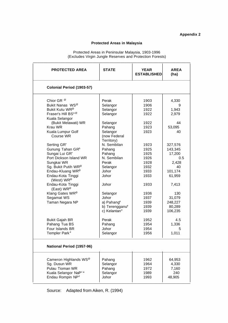
Appendix 2
Protected Areas in Malaysia
Protected Areas in Peninsular Malaysia, 1903-1996(Excludes Virgin Jungle Reserves and Protection Forests)
__________________________________________________________________________
PROTECTED AREA STATE YEAR AREA ESTABLISHED (ha)
__________________________________________________________________________
Colonial Period (1903-57)__________________________________________________________________________
Chior GR @ Perak 1903 4,330Bukit Nanas WS@ Selangor 1906 9Bukit Kutu WR@ Selangor 1922 1,943Fraser’s Hill BSa @ Selangor 1922 2,979Kuala Selangor (Bukit Melawati) WR Selangor 1922 44Krau WR Pahang 1923 53,095Kuala Lumpur Golf Selangor 1923 40 Course WR (now Federal
Territory)Serting GR+ N. Sembilan 1923 327,576Gunung Tahan GRb Pahang 1925 143,345Sungai Lui GR+ Pahang 1925 17,200Port Dickson Island WR N. Sembilan 1926 0.5Sungkai WR Perak 1928 2,428Sg. Bukit Putih WR@ Selangor 1932 40Endau-Kluang WR@ Johor 1933 101,174Endau-Kota Tinggi Johor 1933 61,959 (West) WR@
Endau-Kota Tinggi Johor 1933 7,413 (East) WR@
Klang Gates WR@ Selangor 1936 130Segamat WS Johor 1937 31,079Taman Negara NP a) Pahange 1939 248,227
b) Terengganue 1939 80,289c) Kelantane 1939 106,235
Bukit Gajah BR Perak 1952 4.5Pahang Tua BS Pahang 1954 1,336Four Islands BR Johor 1954 5Templer Park # Selangor 1956 1,011
__________________________________________________________________________
National Period (1957-96)__________________________________________________________________________
Cameron Highlands WS@ Pahang 1962 64,953Sg. Dusun WR Selangor 1964 4,330Pulau Tioman WR Pahang 1972 7,160Kuala Selangor NaPc * Selangor 1989 240Endau Rompin NPd Johor 1993 48,905
__________________________________________________________________________
Source: Adapted from Aiken, R. (1994)

Notes:
@ Overlap either wholly or partly with forest reserve area.
a A small adjoining area (information on size not available) in Pahang wasadded in 1957.
+ Protected areas revoked in 1929.
b Subsequently incorporated into the Taman Negara NP in Pahang. Thismeans an additional 104.822 ha. included to make up the total 248,227 ha.of Taman Negara in Pahang in 1939.
# degazetted from a Park for wildlife and redesignated as an Amenity Forestwithin the Hulu Gombak Forest Reserve in 1996.
c Managed as a Nature Park (although not formally gazetted by law as such)since 1989 by the District Council with assistance from the MalaysianNature Society.
• Overlap with Town Board/District Council area. d Created under the National Parks (Johor) Corporation Enactment 1991 as
a state park (not a national park). As the entire Endau Rompin NP iswithin the Endau-Kluang WR, there is no increase in the overall protectedarea size for Johor.
e area extended in 1995 for all three sectors of Taman Negara.

Appendix 2 (contd)
Gazetted Protected Areas in Sabah, 1963-1996
______________________________________________________________________
PROTECTED AREA YEAR AREA ESTABLISHED (ha)
______________________________________________________________________
PARKS______________________________________________________________________
Crocker Range 1984 139,919Kinabalu Park 1964 73,370Tunku Abdul Rahman Park 1974 1,289 # / 3,640*Turtle Islands Park 1977 15 # / 1,725*Pulau Tiga State Park 1978 607 # / 15,527*Tawau Hills Park 1979 27,972
______________________________________________________________________
CONSERVATION AREAS______________________________________________________________________
Maliau Basin (Gunung Lotung) 1983 39,000______________________________________________________________________
WILDLIFE RESERVES______________________________________________________________________
Kulamba 1984 20,682Tabin 1984 120,521
______________________________________________________________________
TOTAL - 443,997______________________________________________________________________
Note:
# area on land
• area of marine waters

Appendix 2 (contd)
Gazetted Protected Areas in Sarawak, 1963-1996
______________________________________________________________________
PROTECTED AREA YEAR AREA ESTABLISHED (ha)
______________________________________________________________________
NATIONAL PARKS______________________________________________________________________
Bako 1957 2,728Gunung Mulua 1974 52,866Niah 1975 3,140Lambir Hills 1973 6,952Similajau 1976 7,067Gunung Gading 1982 4,196Kubah 1989 2,230Batang Ai 1991 24,040Loagan Bunut 1991 10,736Tanjung Datu 1994 1,379
______________________________________________________________________
WILDLIFE SANCTUARIES______________________________________________________________________
Samunsam 1979 6,092Lanjak-Entimau 1980 168,758Pulau Tukong Ara-Banun 1985 1.4
______________________________________________________________________
TOTAL 290,185.4______________________________________________________________________
Source: Ministry of Science, Technology and the Environment, 1997:57-58