entityregistry.utah · South line of Lot 8, Block 7, Plat "F" Logan Fam Survey; thence West along...
26
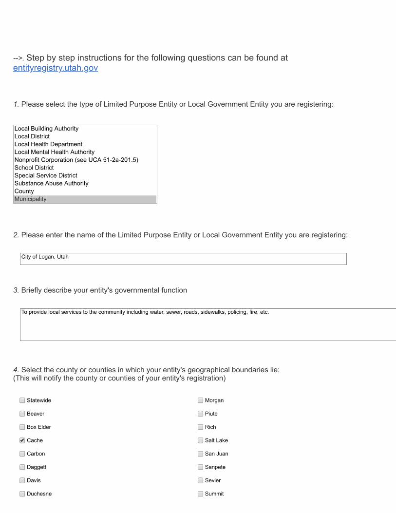
2. 2. Please enter the name of the Limited Purpose Entity or Local Government Entity you are registering: Please enter the name of the Limited Purpose Entity or Local Government Entity you are registering: City of Logan, Utah 3. 3. Briefly describe your entity's governmental function Briefly describe your entity's governmental function To provide local services to the community including water, sewer, roads, sidewalks, policing, fire, etc. -->. -->. Step by step instructions for the following questions can be found at Step by step instructions for the following questions can be found at entityregistry.utah.gov entityregistry.utah.gov 1. 1. Please select the type of Limited Purpose Entity or Local Government Entity you are registering: Please select the type of Limited Purpose Entity or Local Government Entity you are registering: Local Building Authority Local District Local Health Department Local Mental Health Authority Nonprofit Corporation (see UCA 51-2a-201.5) School District Special Service District Substance Abuse Authority County Municipality 4. 4. Select the county or counties in which your entity's geographical boundaries lie: (This will notify the county or counties of your entity's registration) Statewide Statewide Morgan Morgan Beaver Beaver Piute Piute Box Elder Box Elder Rich Rich Cache Cache Salt Lake Salt Lake Carbon Carbon San Juan San Juan Daggett Daggett Sanpete Sanpete Davis Davis Sevier Sevier Duchesne Duchesne Summit Summit
Transcript of entityregistry.utah · South line of Lot 8, Block 7, Plat "F" Logan Fam Survey; thence West along...
22 Please enter the name of the Limited Purpose Entity or Local Government Entity you are registering Please enter the name of the Limited Purpose Entity or Local Government Entity you are registering
City of Logan Utah
33 Briefly describe your entitys governmental function Briefly describe your entitys governmental function
To provide local services to the community including water sewer roads sidewalks policing fire etc
--gt--gt Step by step instructions for the following questions can be found atStep by step instructions for the following questions can be found atentityregistryutahgoventityregistryutahgov
11 Please select the type of Limited Purpose Entity or Local Government Entity you are registering Please select the type of Limited Purpose Entity or Local Government Entity you are registering
Local Building AuthorityLocal DistrictLocal Health DepartmentLocal Mental Health AuthorityNonprofit Corporation (see UCA 51-2a-2015)School DistrictSpecial Service DistrictSubstance Abuse AuthorityCountyMunicipality
44 Select the county or counties in which your entitys geographical boundaries lie (This will notify the county or counties of your entitys registration)
StatewideStatewide MorganMorgan
BeaverBeaver PiutePiute
Box ElderBox Elder RichRich
CacheCache Salt LakeSalt Lake
CarbonCarbon San JuanSan Juan
DaggettDaggett SanpeteSanpete
DavisDavis SevierSevier
DuchesneDuchesne SummitSummit
55 Please upload the entitys creation document or conclusive proof of the entitys lawful creation (If you havePlease upload the entitys creation document or conclusive proof of the entitys lawful creation (If you havequestions regarding this requirement please visit questions regarding this requirement please visit entityregistryutahgoventityregistryutahgov for more information) for more information)
City of Logan Articles of Incorporationpdf572KB
applicationpdf
66 If your entity has geographical boundaries please upload the entitys Map or plat or reasonable proof of If your entity has geographical boundaries please upload the entitys Map or plat or reasonable proof ofboundaries boundaries (If you have questions regarding this requirement please visit (If you have questions regarding this requirement please visit entityregistryutahgoventityregistryutahgov for more for moreinformation)information)
GovernorMap (6)pdf13MB
applicationpdf
77 Please enter the entitys website Please enter the entitys website
wwwloganutahorg
88 Please enter the entitys physical address Please enter the entitys physical address
StreetStreet 290 N 100 W
CityCity Logan
StateState UT
Zip CodeZip Code 84321
99 Please enter entitys mailing address (Leave blank if its the same as the physical address) Please enter entitys mailing address (Leave blank if its the same as the physical address)
EmeryEmery TooeleTooele
GarfieldGarfield UintahUintah
GrandGrand UtahUtah
IronIron WasatchWasatch
JuabJuab WashingtonWashington
KaneKane WayneWayne
MillardMillard WeberWeber
StreetStreet
CityCity
StateState
Zip CodeZip Code
1010 Please enter entitys main phone number Please enter entitys main phone number
435-716-9000
1111 Please enter the designated Primary Contacts information for entity registration related inquiries Please enter the designated Primary Contacts information for entity registration related inquiries
Designated Primary ContactDesignated Primary ContactNameName
Teresa Harris
Designated Primary ContactDesignated Primary ContactEmailEmail
teresaharrisloganutahorg
Designated Primary ContactDesignated Primary ContactNumberNumber
4357169002
FeesFees
TaxesTaxes
BothBoth
1212 Please indicate the source of your entitys revenue (keep in mind this is not specific but big picture)
1313 Please enter the name and the method in which they are elected appointed or otherwise designated of Please enter the name and the method in which they are elected appointed or otherwise designated ofeach governing body member (eg board member commissioner managing officer and other similareach governing body member (eg board member commissioner managing officer and other similarmanager) of the entity If none re-enter the designated contacts name If there are more than 10 membersmanager) of the entity If none re-enter the designated contacts name If there are more than 10 membersplease add them to the comments belowplease add them to the comments below
Appointed Elected Other
NameName Holly H Daines
NameName Jeannie F Simmonds
NameName Amy Z Anderson
NameName Tom Jensen
NameName Herm Olsen
NameName Jess W Bradfield
NameName
NameName
1414 Please upload information regarding any assessment areas created by your entity Please upload information regarding any assessment areas created by your entity
15-23 Assessment Area No 3 350 Southpdf33MB
applicationpdf
1616 Comments or Questions Comments or Questions
Location Data
NameName
NameName
1515 By signing below you attest to the validity of the information you have entered The requirement to submityour information will include the $50 registration fee as well as the information listed above Once you havecompleted this form you will be directed to pay the fee Within thirty days of receipt of your information and fee the Lt Governorrsquos office will send notice of 1) anydeficiency or incomplete submission or 2) your entityrsquos compliance and valid registration Please note thisinformation will be made publicly available
times
1717 CC
clear
Location (41746795654297 -11182679748535)
Source GeoIP Estimation
OFFICE OF THE LIEUTENANT G0VEROORSFpoundRETARY OF SfATE
C E R T I F I C A T E
I DAVID S MJNSON LT GOVblWJRSECRETARY OF SfATE OF THE SfATE
OF lJIAH HEREBY CERJIFY THAT there has been filed in my office a certified
copy of the Articles of Incorporation of the CITY OF LOGAN canplying with
Sections 10-2-108 and 109 Utah Code Annotated 1953 as amended 1977
JIOW THEREFORE in canpliance with the requirements of Section
10-2-108 notice is hereby given to all whCJn it may concern that all of the
territory described in the attached Articles of Incorporation has been inshy
corporated i nto a city tmder the name of the CITY OF lOGAN located in Cache
County State of Utah
IN TESfOONY WHERFOF I have hereW1to set my hand and affixed the Great Seal of the State of Utah at Salt Lake City this 25th day of May 1978
ARTICLES OF INCORPORATION OF THE CCTY OF LOGAN A Municipal Corporation of the State of 1thtiAy 22 Alf ()
45
ARTICLE ONE Name The name of this municipal corporation is the
CI1Y OF LOGAN
ARTICLE TWO Geograohical Description The geographical description of this municipality is
(See Exhibit A attache d hereto)
ARTICLE THREE Population Accordlng to Class The City of Logan is a city of the second class and has a population of 27000
Dated this ~ay of ~ 1978
STATE or UTAH
County of Cache ss
Walter N Nickel Mayor
VERIFICATION
The undersigned having been first duly sworn deposes and states that I a m the duly qualfied mayor of the City of Logan a municipal corporation of the State of Utah that I am the person who signed the foregoing instrument that I have read the foregoing instrument and know its contents and that the matters stated therein are true to the best of my knowledge information and belief
Walter N Nickel Mayor
Subscribed and sworn to before me this ~ay of ~ -19 78
7vly Commission Expires Reliding ol logor U101
Colllllll b plm 8-30-61
l
~~ ~ N~~ Residing at Logan Utah
I I
I
EXHIBIT A
CORPORATE LHiITS OF LOGCl CITY UTAH
The following description vias taken from data taken from the County Recorcers
records and the records of the Logan City Corporation Scid data includes the
original Charter and Amendments enacted by the Govenor and Legislative Asseiily
of the Territory of Utah February 13 1873 a11 subsequent official Arendments-
restrictions and annexations thereto The purpose of this description is to
describe the Corporate Boundaries as they appear in said records
Beginning at a point on the South bank of Lo9an River 1320 feel East and
561 feet South of the North1middot1est corner of Section 36 To~nship 12 tlorth P_ange
1 East of the Salt lake Base and Meridian and running thence South 264 ~eet
thence East 1320 feet thence South 495 feet rore or 1 ess to a po int 1320 feet
South of the 1lorth quarter corner of section 36 thence East 1320 feet thence
tlorth 820 feet more or less to the i4orth Bank of Logan River thence imiddotesterly
along said North Bank 370 feet more or less to a point 9312 feet East and
4422 feet South of the North quarter corner of Section 36 thence ilorth middot442
feet more or less middot to the North 1 ine of Section 36 thence West 931 feet r1ore
or less to the North quarter corner of Settion 36 thence North on the-~orth~
South centerline of Section 25 Township 12 1orth Range l East 40 chains moremiddot
or less to the center of said Section 25 thence I-lest along the _East-~est
centerline of Sect ion 25 to a point on the gtest 1 i ne of Logan-Hyde Park-Snithfi e 1 d
C~nal thence Hortherly along the ~est line of said conal to the iorth line
of said Section 25 thence North 20deg24 ~est 28925 feet and ~orth 0deg31 ~est
_67 57 feet paralleling the West Bank of the Logan-Hyde Park-Srithflelri Canal
thence Horth 0deg16 1 13 West lOOG46 feet thence South 89deg51 10 eurost 559 feet
ioore or 1ess to the Iest Barlt of the Lo~ar-Hyde Park-Sriithfield Canal thence
South along said bank 12 feet thence South 69deg51 10 1middotest 733 feet r1ore
or less to the East line of
Corpo rcte Limits Of Logan City Utah Pa9c 2 Continued
sixteenth East Stre~t thence Southerly along the East Right-of-way line of
Sixteenth East Street in three courses to wit South 4deg0520 West 9987 feet
South 0deg2432 East 890 12 feet South 0deg2300 East 346 feet more or less
to the Horth~1est corner of Section 25 thence est along the Herth 1 ine of Section 26 3790 feet more or less to the est bank of the Logan florthern
Ganal thence Northerly along said West bank tSO feet more or less to the
South line of Lot 8 Block 7 Plat F Logan Fam Survey thence West
along lot lines 8170 feet ~ore or less to the East line of 200 West Street
which point is also the Jforthwest corner Lot 2 Block 7- Plat D Logan Farri
Survey in the Southeast quarter Section 21 thence South along the East
line of sai d Second West Street 2715 feet thence West 1353 feet thence
South 363 feet more or less to the centerline of Section 28 thence West
1255 feet more ormiddot less to the East line of Sixth West Street thence i~orth
along the East line of Sixth West Street 2420 feet more or less to the South
lfne of Fourteenth Horth Street thence West along the South line of
Fourteenth North Street 1320 feet thence torth 660 feet thence West 1320
feet thence South 660 feet more or less to the Southeast corner of the
intersection of 1000 middotlest and 1400 North Streets thence Hes t 660 feet more
or less to the Northwest corner of lot 6 Block 13 plat C Logan Hayland
in the Northeast quarter section 29 thence South along lot lihes of BloLks
n and l Logan Hayland and Block 35 lat Logan farm Survey 5940 feet
more or less to the South line of 600 iiorth Street thence West 660 feet
thence South 660 feet more or less to tre So~th line of Lot 8 Block 35
P1at E Logan Farm Survey thence East 660 feet thence South 1320 feet
lilOre or less to middotthe Northeast corner lot 3 Block 35 in the ifortheast
qu~rter Section 32 thence Hest 660 feet trence South 660 feet rrore
or less to the North line of Utah State Hi~n~ay 29 thence East 1336 feet
rroere or less middotto the East lire of lOOC lest Sreet thence South 3775 feet
more or less to the East middotest quarter Section lire of middotthe tortheast quarter
I
Corporate Limits Of Logan Page 3 Continued
Section 5 Township 11 North Range 1 East of the Salt Lake Base and Meri_dian
thence West 860 feet more or less to the West quarter corner of the
Northeast quarter of said Section 5 thence South 40 chains more or less middot to
the West quarter corner of the Southeast quarter of said Section 5 thence
East 727 feet more or less to the East line cf 1000 Hest Street thence
South along the East line of 1000 ~lest Street 80 rods more or less to the
North line of 1000 South Street thence East 84 rods ~ore or less to a
poi nmiddott 40 rods West of the est 1 i ne of 1000 middotlest Street thence South 68 rods
th~ce East 30 rods thence North 8 rods thence East 10 rods more or 1 es s
_to the lest line of 1000 West Street thence North 867 rods more or less
to the South Southeast corner Section 5 Township 11 North Range 1 East of
the Salt Lake Base and Meridian thence East 3240 feet more or less to
themiddot South East corner of Section 5 thence South 585 feet riore or less to
a point 32 feet ilorth of the South line of Lot 14 Block 3 Plat B Providence
farm Survey thence East 265 feet mroe or less to the ~est 1 ine of a Fielq Street
thence South 362 feet more or less to the Southeast corner of Lot 15
said Block 3i thence South 130 feet more or less to the East right of
way line of Highway 39 and 91 thence South1middotester1y 4480 feet more or less
to the North right of way line of a county road thence S0utheastermiddot1y a 1 ong
th florth line of a county road 1790 feet more or less to the East line
of a laquoorth-South county road extended thence North 1450 feet more er less to
a point 85 feet South of the South right of way line of a State Road thence
$-Outh 88deg18 East 650 feet thence Soith 88deg50 East 795 30 feet more or 1 ess
to a point 120 feet East of the East line of a county road thence iorth 00deg45
East 9225 feet thence tlorth 48deg23 est 153 91 feet~ r1ore or less to the
East line of a State Road thence Northeaster1y along said East line o_f the
State Poad 400 feet more or l ess to the point of intersection of said East
road line with the South line of a county street the-ce ~est a lens said South
Corporate limits Of Logan Page 4 Continued
line of the county street 200 feet more or less to its intersection ~tith the East Bank of the South Fork of the middotsouth aranch of Logan Riverj thence
Northeasterly a1o~ said East Bank 620 feet ~ore or less to a pointmiddot245 chains South of the South lot line of lot 4 Block 4 Plat 8 Providence Farm Survey thence East 100 feet thence South 80 feet thence East along fence line 390 feet QOre or less to the East line of a State Road thence ilortheasterly along the East line of said State Road 1110 feet rore or less to the East line of State Highway thence North along the East line of State Highway and the East line of Highay B9 2nd 91 2700 feet more or less to the South Bank of the South fork of Logan River thence llortheasterly along the South Bank of the South fork of Logan River to a point in the South line of 100 North Street thence around a regular curve to the right having a radius cf 358l feet for an arc distance of 10304 feet thence South 12deg10 33 East 95feet thence around a regu1ar curve to the left having a radius of 50674 feet for an arc distance of 11730 feet therce South 85deg1318 East 345 feet thence South 38deg00bull East 640 feet thence North 89deg59 East 40 feet
thence South 26deg21 30 West 13530 feet thence South 80deg2900 West 20600 feet thence South 37deg3130 West 6010 feet thence South 6deg0530 ~est
0 middot 0 8505 feet thence South 17 1630 East 14560 feet thence South 40 3830 East 159 20 feet thence South 22deg30 est 22990 feet more or less to a point 12804
feet West of the Southeast corner of the S0utl11middot1est quarter Section 35 Township 12 North Rangel East thence E2st 12804 feet thence North 495 feet thence East 2145 feet thence South 1815 feet thence West 2145 feet thence S_outh 1310 feet thence South 87deg10 East lG8 feet thence North 190 feet more or less to the East ~est quarter - ~uarter Section line of the Northeast quarter Section 2 TcwnShip 11 Horth Rangel East thence East alonJl_ sa1d line 3762 feet mormiddote or less to the E2st quarter correr
of the Northwest quarter Section 1 said To-mship 11 iorth thence ~gtrth along the centerline of Section 1 1320 feet rore or less to the orth line of To~mship 11 North Rante l East of tile Salt Lake Base and_ eridian thence Hest along said To~middotmship line 2540 feet rore or less to the Southmiddottest corner of Section 36 Township 12 North Range 1 East thence South 165 feet thence West 198 feet thence North 193 feet thence East -93 feet roe or
Corporate Limits Of Logan
Poge 5 Continued
less to the Iest line of said Section 36 thence iorth along
said West Section line 3404 feet more or less to a point i-Orth J1deg0533 Vest 136 feet of the Northwest corner of the S0uth~1est quarter said Section
36 thence South 88deg5427 ~lest 445 feet more or less to the middotsouth Banlr
of Legan River thence Northeasterly along said river bank 1500 feet mor-e
or less to the point of beginning
Date of description March 22 1978
OFFICE OF THE CITY ATTORNEY
CITY OF LOGAN 61 WESTFIRSTNORTH
LOGAN UTAH 84321
-fl
W SCOIT BARRETT CITY ATlORNEY
DOUGLAS M BRADY ASST CITY ATlORNEY
HEMORANDUM
TO WHGI IT COOCEFN
RE Logan City s Charter
Cll January 17th 1866 the Governor and the legislative Assembly of the Territory of Utah granted to tile City of Iogan a charter under which ~ city has continued to operate pursuant to mrerrlrrents to that charter and subsequent state law to the present tine In my opinion that Charter is valid and continuing and there has been no break in the authority of the City to operate under that charter
Mum the Constitution of Utah was adopted Article XI Section 5 originally read Cotporations for mmicipal purposes shall not be created by special laws he legislature by general laws shall provide for the incorporation organization and classification of cities and towns in proportion to pcIlation which laws may be altered anended or appealed middot
That section as stated above remained as written until an airendirent was made in 1932 to take effect January 1 1933 lbe arreudrcent provided for any city to adopt a bane rule charter by ~thirds vote of the oouncil and upon petition of qualified electors he mrendment also stated that any existing charter would be middot superoeded by adoptionmiddot of a tune rule charter Iogan City did not have such an election and did not beamE a bane rule chartered city Because of that sace ha~ stated that IDgan is not a charter city
HcMever it is not correct to say that Iogan is not a charter city Ihe constitutional mrendrrent providing for hcma rule charters was supposed to give cities who adopted a bane rule charter a little rore autoncmy and authority than they othetwise would have Ho1ever in 1980 a 9lprene Court case for all practical puqxgtses did away with the differences between a hare rule charter and an ordinary charter In State v Hutchison decided by the SUptEe Court in 1980 it was held that the cities tams and rounties of Utah had been delegated broad ~rs to acocnplish their general purposes The Court held that
When the s~te has granted general welfare power to local governments those local governments have independent autlxgtrity apart fran and in addition to specific grants of authoritY to pass ordinances which are reasonably and appnpriately related to the objectives of that power ie providing for the plblic middot safety health rrorals and welfare
--
Logan City Charter Page 2
In the opinion of Michael T raquoCoy general counsel to the Utah league of Cities and Towns State v Hutchinson hias essentially cbviated the advantages of the haoo rule charter if there were any before the Hutchinson case Thui the City of Dgan is a city qierating under a charter granted originally by the territorial govermlPnt even though it did not adopt the lune rule charter as provided in 1933 by amendment to the Utah constitution
In 1977 the Utnh State legislature enacted caiprehensive legislation cxgtneerning the incorporation of nunicipalities as set forth in Title 10 of the Utah Code Section 10-2-108 provided for inoorporation of nunicipali ties whether new or existing Pursuant to that legislation the City of Dgan filed with the Office of the Lieutenant Governor Articles of Inoorporation of the City of IDgan dated the 18th of May 1978
In my opinion therefore IDgan City is a nunicipal oorporation operating as such under the laws of ~ State of Utah and was originally charted in 1866 by the Territory of Utah which charter has continued without interruption to the present day
DATED this 11th day of February 1985
w Soott Barrett IDgan City Attorney
----middot middot
middot- middot~gt
~
-
middot
~ -~ ~ 1 r middotmiddot~( -~~f I middotmiddot ~ ) t~ ~ middot middot~ ) ~ t )
l ~ ~ i 1~ 7 I J ~
~ middotmiddot ~ ~ ( ~
)1 ~ ~ ~~ i 4 ~ ~-~ ~ () bull ~ ~ ~ ~ 1 ~ ~ ~ ~ ~ ~ f
bull I~ 0
k
k
k
k
k
k
k
k
k
k
k
k
k G
GG GGG
GGG G
GGG G
GG GG
G
GG G
G GG
GG G
G G
GG
G
GG
G
G
G
G
G
G
G
G
GG
G
G
G
G
G
G
G
Z
[
K
$
700
N
1000 N 200
E
200
W
600
E
700 S
1000 N
600
W
100 N
GOLF COURSE
PRES
TON
1580
N
MOUNTAIN
200 S
1700
E
1350 N
1530 N
1300 N
600 N20
0E
500 N
1500 N
200 N
290
S
1124
N
1500
E
700 N
400
W
MA
IN
2000 S
1400
E
300
W
350
W
220
W
1200
W
900
S
1200 N1140 N
400
E
1500
E
900 N
TALO
N
730
W
TAXIWAY
A
CANYON
WIN
DING
US 8991
400
W
600 S
470 N
BOULEVARD
725 N
JOHNSON LN
1365
W
EMM
E
680
E
1760
N
ELLENDALE
1400 N
350
E
1580
W
1200 N
400
E
1230 S
1450W
MAPLE
DEERCREST
600 S
200
E
100 N
1000
W
EASTRIDGE
800 N
260
E
1430
E
800
W
225 E
LEGRAND
780W
200 N
330 S
1260 N
THREE POINT
260 N
1330 N
1200 N
US 89
1400 N
100
W
300
E
880 N
PENNY
1460 N300
W
100 S
810 N
1250
W
870 N
400 S
700 N
1150 N
1490 N
690 S
1080 N
1000 S
1170E
1570 N
1800 S
1400 N
200 S
500 N
1200
E
CENTER
300 S
700 N
800 S
CENTER
100 S
1458
S
890
S
100
W
700 S15
20 E
500
E
830 S
1385
N
1600 N
3000 S
600
W
1640
E
1550 N
400 N
300
E
600 N
300 S
500
E
1025 N375
W
800 N
400 N
800 S
HIL
LCR
EST
800 N
1960
S
900 N
1420E
1465 N
1400
E 1730
E
1700 S
RO
SE
500 N
CANTERBURY
1425 N
500
E
1330
W
300 N
240 S
400 N
800 N770
N
900 N
200
E
THRUSHWOOD
800
W
180
W
240
W
800 S
100 N
1780 S
230
N
350 E
RED
FOX
2500 N
640S
370 S
525
E 750 E
1240
W
1800 N
570 E
150W
500
S
560
W
1140 N
220
W
560 E
870
WAI
RPO
RTDR
300 N150
W500
W
80 W
430 S1595 N
500 S
CACHE
VALLEY
565
W
1155
N
630
W
720 S
1240 N
970
N
1455
N
1550
S
550 N
1200
N
970E
200 S
CEDA
RHE
IGHT
S
100 S130 S
1350
N
1480 E
1600 N
1030 N
1420 N1460 N
1000 N
550
N
PARK
1140
N
800
W
1375 W
640
S
1100
S
1140
N1574S
1100 N
310
W
200 S
230
W
1400W
980W
365 S
QUAILCANYON
320
W 1140
N
700
E
1100N
400
E
GREENVIEW
1400
W
HYCLONE
1600 S
2200 S
1100
N
1470
N
670
W
800 NAggie Bullevard
100
E
340W
SOU
THW
EST
710
W
1260
N
DEE
CEN
TER
700
E
500
E
870 N
700
W
300
E
800 N
RIVER
PARK
1300
E
1700 N
1900
W
50 W
500
E
900
E
300
W
250 N
1175 W
200
W
280 S
2000 W
400 S
100
W
200
W
50 W
550 S500 S
200 S
900 N
900 N
775 N
1250 N
800
E
100W
300 N
1250E
1200
W
400 S
100 S
700 N
CACHE
GATEWAY
1200 S
1650 N
530 S
1100 N1050 N
1400 N
SUNSET
1900 S
STADIUM
2600 S
2200 S
400 N
KC
850
W
1120 N
950
W
750 N
1200 S
1800 S
LYNNWOOD
1200
W
2200 N
CANYONPARK
AUTO MALL
500 N
1700 N
HYCLONE
CACHE
VALLEY
1000 N
600 N
HOSPITAL
1400
W
FOXFA
RM
AIRPORT19
00 W
2600 S
1600
E
GIB
BO
NS
300
W
ASPE
N
1100
W
400
E
500
W
LEG
END
QUAIL
600
E
600 E
830
W
KING
S
MT
LOGAN
1380
W
100
E10
0 E
TRAIL
500W
RIVERSIDE
540
W
500
W
PAR
KPA
RK
315
WRI
VERW
ALK
1300
E
540
W
SUMAC
1525
E
1750E
CLIFFSIDE
575
W
1360 W
300
W
COUNTRY
MANOR
BRISTOL
1770
E
2000
W
1250
E
520
W
800
E80
0 E
900
W
1150W
670W
880N
OA
KW
OO
D
150
W
1400 E
375 W
350
W
1000 W
50 E
50 E
1170
E
250 E
1540 W
RSI
1120
W
800
W
CHAMP
1075 N
275 N
100W
TEAL
1280
W
ISLAND
1800 N
MEADOW
1600
W
TAXIWAYFL
1200
W
Legend
Z Logan Cache Airport
K Logan Regional Hospital
[ Logan City Hall
$ Utah State University
OTHER LANDMARK
G CHURCH
k School
State Roads
Public Roads
Private Roads
USU Roads
Parks
Logan City Boundary
sup20 1 205 Miles
LOGAN CITY STREET MAP -MAY 2019
En 1138414 Bk 1876 Pg 744 CITY OF LOGAN Da~ 1o-Dec-2015 12 19 PIt fee $00
RESOLUTION NO 15-23 Cach e Co u nty UT ichael Gleed Rec - filed BIJ 6C
A RESOLUTION DESIGNATING THE 350 SOlfr~ffiiB AND GUTTER ASSESSMENT AREA NO3
WHEREAS it is proposed to establish an Assessment Area pursuant to UCA sect 11-42-1 0 1 et seq for the purposes of funding curb gutter and related improvements on 350 South between 1200 West and 1350 West and
WHEREAS the Logan Municipal Council gave notice and held a public hearing on July 7 2015 to hear all objections and comments regarding the proposed Assessment Area and
WHEREAS the 60 day protest period has expired and no protests were filed to the proposed Assessment Area and
WHEREAS the Logan Municipal Council now deems it appropriate to designate the Assessment Area as set forth in the Notice of a Proposed Assessment Area
NOW THEREFORE BE IT RESOLVED by the Logan Municipal Council that
1 The Municipal Council of the City of Logan Cache County Utah finds and determines that it is in the best interest of said city to improve 350 South by installing curb and gutter approaches storm drainage and other appurtenant improvements and hereby designates an assessment area formally known as Assessment Area No3 of the City of Logan to accomplish said purpose
2 The area to be benefited the improvements manner of assessment and other required information for Assessment Area No3 is more particularly described in the Notice of Proposed Assessment Area Designation which is attached and incorporated by reference as part of this resolution
3 A portion of the cost and expenses of Assessment Area No3 shall be paid by an assessment to be levied against the property within the assessment area benefited by the improvements Such assessment shall be levied on the basis of street frontage of each parcel in the Assessment Area as set forth in the Notice of Proposed Assessment Area Designation and shall be for a period of five years
k DAY OF
NOTICE OF PROPOSED ASSESSMENT AREA DESIGNATION
En 1 1 38414 Bk 1876 Pg 745
Notice of a Proposed ASSESSMENT AREA Designation
Public Notice is hereby given that the Logan Municipal Council proposes to designate ASSESSMENT AREA
No 03 (ASSESSMENT AREA) in the City of Logan Cache County Utah for the purpose of installing curb
and gutter and appurtenant improvements and to pay some or all of the costs of the improvements by
an assessment as provided in Chapter 11 Title 42 UCA 1953 as amended on the property within said
ASSESSMENT AREA for the benefit of the property being assessed
Ent 1138414 Bk 1876 P9746 The proposed ASSESSM ENT AREA is shown in Attachment A The general description of the ASSESSMENT
AREA includes all properties located on the frontage of 350 South between the addresses of 1203 West
to 1337 West The improvements proposed will include the following
bull Install curb gutter and approaches along 350 South between 1200 West and 1337 West
bull Install storm drainage as needed to manage storm water runoff
bull Improve existing corners to meet ADA requirements
bull Revegetate areas that are disturbed behind the curb and gutter
The City of Logan proposes to levy an assessment on benefitted property within the ASSESSM EIlT AREA
to pay some or all of the costs of the improvements according to the estimated benefits to the property
from the improvements Attachment B provides a figure identifying the locations of the proposed
improvements If this is mailed notice to a specific owner of property to be assessed within the
proposed ASSESSMENT AREA the estimated total assessment specific to the benefitted property for
INhich this notice is mailed is provided in Attachment C The estimated costs for the project have been
estimated by a project engineer and are based on recent prices of construction in Logan The specific
items that are included in the proposed ASSESSMENT AREA are included in the cost estimate provided in
Attachment D The estimated total costs for the project improvements are $120708 and will be paid by
an assessment to be levied against the properties abounding abutting upon or adjacent to the roadway
area which will be benefitted by said improvements Assessment shall be levied on the basis of linear
feet of frontage immediately adjacent to 350 South The estimated cost of $3750 per foot of frontage of
the real property adjacent to said improvements is the basis of assessment for each parcel and is
according to the estimated benefits to the property from the improvements If the actual construction
costs for the improvements are less than the estimate then the estimated cost per foot of frontage will
be reduced accordingly
The assessment may be paid by the abutting property owners in five (5) equal annual installments If
after five (5) years a balance still remains to be paid an interest rate often (10) percent per annum will
be charged until the assessment is paid in full The assessment will be collected by inclusion on a
property tax notice issued in accordance with UCA 59-2-1317 and in compliance with UCA 11-42-401
On July 7 2015 the Municipal Council and Mayor will meet at the Municipal Council Chambers located
at 290 North 100 West Logan Utah to hear and consider any comments to the proposed improvements
or to the creation of the ASSESSMENT AREA ANY PROTEST TO THE DESIGNATION OF THE
ASSESSMENT AREA OR TO BEING ASSESSED FOR THE PROPOSESED
IMPROVEMENTS OPERATION AND MAINTENANCE COSTS MUST BE FILED IN
WRITING Any protests to the proposed ASSESSMENT AREA shall be in writing and signed by the
owner or owners of the property that is proposed to be assessed and who does not want the property
to be included in the ASSESSMENT AREA The written protest shall contain a description of the owners
property (lot block address etc) and shall be filed with the City Recorder Logan City Offices 290 North
100 West Logan Utah on or before 500 pm on September 8 2015 The creation of the ASSESSMENT
AREA shall be abandoned if the necessary number of protests has been timely filed The necessary
number of protests means protests representing at least forty percent (40) of the linear frontage of all
the property to be assessed
En1 11384 14 Bk 1876 P9 747
ATTACHMENT C 350 South Curb and Gutter
Owners 50 Cost Annual cost over 5
Address Parcel Number Frontage (ft) ofTotal Share years Cost per foot
1337 West 350 South 02-133-0310 9043 568 $339113 $67823 $3750 1313 West 350 South 02-133-0311 9043 568 $339113 $67823 $3750 1305 West 350 South 02-133-0312 9043 568 $339113 $67823 $3750 1293 West 350 South 02-133-0313 9067 570 $340013 $68003 $37 50 1271 West 350 South 02-133-0314 9067 570 $340013 $68003 $37 50 1253 West 350 South 02-133-0315 9067 570 $340013 $68003 $37 50 1235 West 350 South 02-133-0316 9067 570 $340013 $68003 $3750 1211 West 350 South 02-133-0317 9067 570 $340013 $68003 $37 50 1203 West 350 South 02-133-0318 7064 444 $2649 00 $52980 $3750 1204 West 350 South 02-133-0301 7066 444 $2649 75 $52995 $37 50 1210 West 350 South 02-133-0302 90 67 570 $3400 13 $68003 $37 50 1234 West 350 South 02-133-0303 9067 570 $340013 $68003 $3750
1254 West 350 South 02-133-0304 9067 570 $340013 $68003 $37 50
1276 West 350 South 02-133-0305 9067 570 $340013 $68003 $37 50 1292 West 350 South 02-133-0306 9067 570 $340013 $68003 $3750 1306 West 350 South 02-133-0307 9048 569 $339300 $67860 $37 50 1312 West 350 South 02 -133-0308 9048 569 $3393 00 $67860 $37 50 1336 West 350 South 02-133-0309 9048 569 $339300 $67860 $37 50 Totals 159073 10000 59652 38
~ ~ ~ CXI ~ ~ ~
CXI -J 0shyV
c
bull-J
CXI
ATIACHMENT 0
350 South Oakwood Dr - 1400 West Street Improvements Project Estimate
Oakwood Dr - 1350 West (Public Cost) ENGINEERS ESTIMATE ITEM UNIT TOTAL NO ITEM UNIT QUANT PRICE PRICE
1 Prepare and Implement Traffic Control Plan Is 1 $500000 $500000 2 Implement Storm Water Pollution Prevention Plan Requirements Is 1 $250000 $250000 3 Remove and Dispose Existing Drain Pipe ea 0 $1200 $000 4 Remove Existing Flat Concrete sf 2000 $075 $150000 5 Remove Existing Asphalt Pavement sf 0 $030 $000 6 Remove Existing Catch Basin ea 2 $30000 $60000 7 Construct Hot Plant Asphalt Mix ton 0 $8000 $000 8 Construct Curb and Gutter APWA Type A If 2250 ~1700 $3825000 9 Construct 4 Sidewalk If 350 $2500 $875000
10 Construct Flat Concrete If 0 $450 SOOO 11 Construct Flare Driveway Approach sf 2000 $500 $1000000 12 Adjust Manhole ea 0 $45000 $000 13 Adjust Water Valve ea 0 $30000 $000 14 Construct ADA Ramp ea 2 $300000 $600000 15 Roadway Excavation cy 180 $800 Sl44000 16 Construct Top Soil cy 180 $3500 $630000 17 Construct Sod sf 0 $030 $000 18 Furnish and Plant Trees ea 0 $25000 $000 19 Construct 15 Inch PE Drain Pipe If 250 $3500 $875000 20 Granular Borrow cy 100 $2000 S200000 21 Crushed Aggregate Base cy 125 $2800 S350000 22 Construct Catch Basin ea 4 $ 150000 $600000
TOTAL OF BASE BID (Public Portion) $10059000 CONTINGENCY 20 S2011800
TOTAL S12070800
Ent 1 13_9414 Bk 1876 Pq 7 49
CACHE VALLEY PUBLISHING CO ISJ PAYMENT PROCESSING CENTER
PO BOX 1570 POCATELLO ID 83204
(435)752-2121
ORDER CONFIRMATION
Salesperson Jaime Maw Printed at 060115 0837 by jma13
Acct 180841 Ad 1293195 Status N
LOGAN CITY LEGAL Start 06022015 Stop 06232015 290 NORTH 100 WEST Times Ord 4 Times Run LOGAN UT 84321 LEGL 200 X 8200 Words 666
Total LEGL 16400 Class 0006 GOVERNMENT NOTICES Rate LG Cost 63412 Affidavits 1
Contact Ad Descrpt TERESSA HARRIS Phone (435)716-9797 Given by Fax (435)716-9797 Created jma13 060115 0823 Email lorimathysloganutahorg Last Changed jma13 060115 0834 Agency
PUB ZONE ED TP START INS STOP SMTWTFS HJ A 97 S 0602091623
Ent 1138414 Ok 1 876 PC) 751WEB A 97 S 0602091623
AUTHORIZATION
Under this agreement rates are subject to change with 30 days notice In the event of a cancellation before schedule completion I understand that the rate charged will be based upon the rate for the number of insertions used
Name (print or type) Name (signature)
(CONTINUED ON NEXT PAGE)
CACHE VALLEY PUBLISHING CO ISJ PAYMENT PROCESSING CENTER
PO BOX 1570 POCATELLO ID 83204
(435)752-2121
ORDER CONFIRMATION (CONTINUED)
Salesperson Jaime Maw Printed at 060115 0837 by jma13
Acct 180841
Notice of a Proposed ASSESSMENT AREA Designation
Public Notice is hereby given that the Logan Municipal Council proposes to designate ASSESSMENT AREA No 03 (ASSESSMENT AREA) in the City of Logan Cache County Utah for the purpose of installing curb and gutter and appurtenant improvements and to pay some or all of the costs of the improvements by an assessment as provided in Chapter II Tille 42 UCA 1953 as amended on the property within said ASSESSMENT AREA for the benefit of the property being assessed
The general description of the ASSESSMENT AREA includes all properties located on the frontage of 350 South between the addresses of 1203 West to 1337 West The improvements proposed will include the tollowing
Install curb gulter and approaches along 350 South between 1200 West and 1337 West Install curb gulter and approaches where applicable along the west side of 1200 West for the corner parcels Install stonn drainage as needed to manage storm water runoH in the intersection of 1200 West and 350 South tmprove eXisting intersection corners to meet ADA requirements Restore areas that are disturbed behind the curb and gutter
The City of Logan proposes to tevy an assessment on benefilted property within the ASSESSMENT AREA to pay some of the costs of the improvements according to the estimated benefits to the property from the improvements The estimated costs for the project have been estimated by a project engineer and are based on recent prices of construction in Logan The estimated total costs for the project improvements are $120708 and a portion will be paid by an assessment to be levied against the properties abounding abutting upon or adjacent to the roadway area which will be benefitted by said improvements Assessment shall be levied on the basis of linear feet of frontage immediately adjacent to 350 South The City of Logan will pay 50 of the estimated total costs for the project The estimated cost of $3750 per foot of frontage of the real property adjacent to said improvements is the basis of assessment for each parcel and is according to the estimated benetits to the property from the improvements If the actual construction costs for the improvements are less than the estimate then the estimated cost per toot of frontage will be reduced accordingly
The assessment may be paid by the abutting property owners in live (5) equal annual Installments If aller five (5) years a balance still remains to be paid an interest rate 01 one and one-hall (15) percent per annum will be charged until the assessment is paid in full The assessment will be collected by inclusion on a property lax notice issued in accordance with UCA 59-2-1317 and in compliance with UCA 11-42-401
On July 7 2015 the Municipal Council and Mayor will meet at the Municipal CounCil Chambers located at 290 North 100 West Logan Utah to hear and consider any comments to the proposed improvements or to the creation of the ASSESSMENT AREA ANY PROTEST TO THE DESIGNATION OF THE ASSESSMENT AREA OR TO BEING ASSESSED FOR THE PROPOSESED IMPROVEMENTS OPERATION AND MAINTENANCE COSTS MUST BE FILED IN WRITING Any protests to the proposed ASSESSMENT AREA shall be in writing and signed by the owner or owners 01 the property that is proposed to be assessed and who does not want the property to be included in the ASSESSMENT AREA The written protest shall contain a description 01 the ownerslY property (lot block address etc) and shall be filed with the City Recorder Logan City Offices 290 North tOO West Logan Utah on or before 500 pm on September 8 2015 The creation 01 the ASSESSMENT AREA shall be abandoned if the necessary number 01 protests has been timely filed The necessary number of protests means protests representing at least forty percent (40) 01 the linear Irontage of all the property to be assessed
Teresa Harris Logan City Recorder Publication Dates June 2 June 9 June 16 and June 23 2015
Ad 1293195 Status N
Ent 1138414 Bk 1876 Pg 752
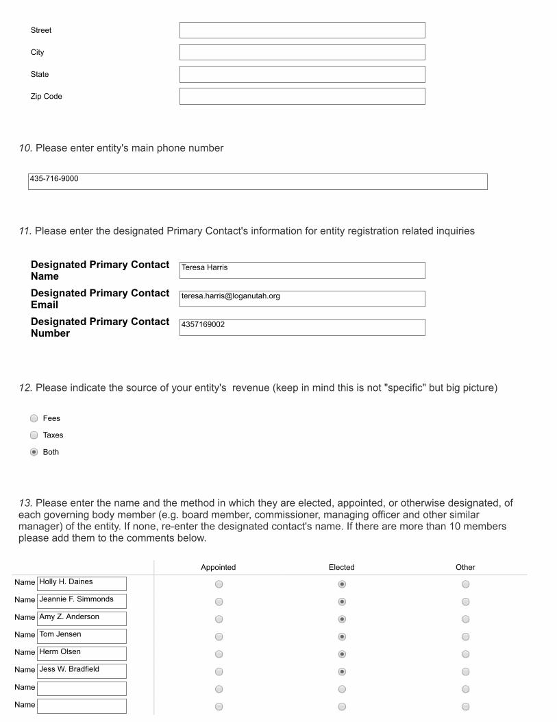
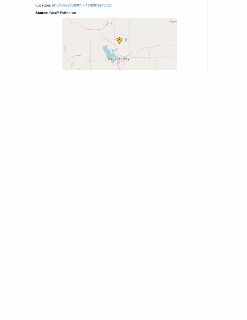
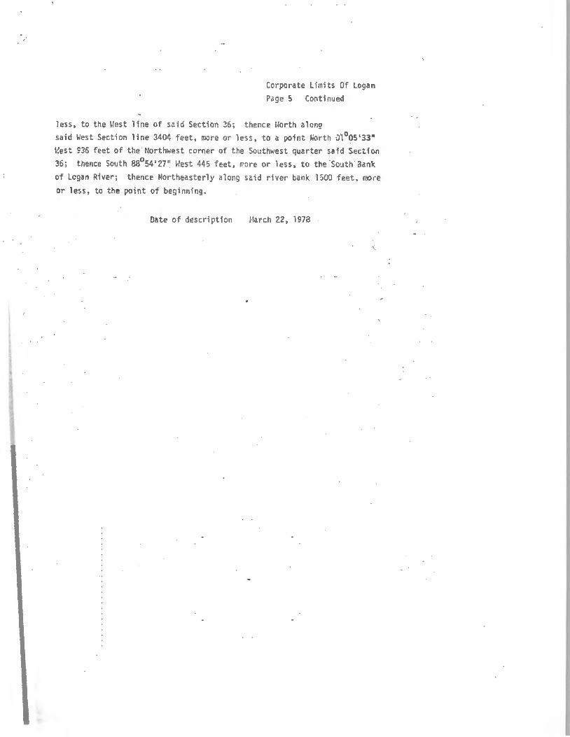
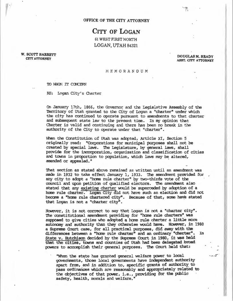
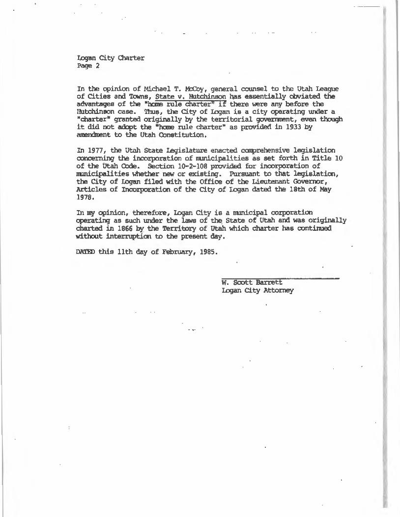
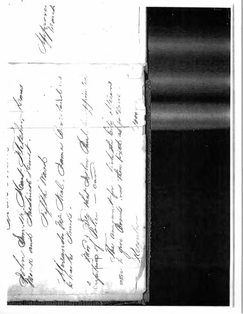

k
k
k
k
k
k
k
k
k
k
k
k
k G
GG GGG
GGG G
GGG G
GG GG
G
GG G
G GG
GG G
G G
GG
G
GG
G
G
G
G
G
G
G
G
GG
G
G
G
G
G
G
G
Z
[
K
$
700
N
1000 N 200
E
200
W
600
E
700 S
1000 N
600
W
100 N
GOLF COURSE
PRES
TON
1580
N
MOUNTAIN
200 S
1700
E
1350 N
1530 N
1300 N
600 N20
0E
500 N
1500 N
200 N
290
S
1124
N
1500
E
700 N
400
W
MA
IN
2000 S
1400
E
300
W
350
W
220
W
1200
W
900
S
1200 N1140 N
400
E
1500
E
900 N
TALO
N
730
W
TAXIWAY
A
CANYON
WIN
DING
US 8991
400
W
600 S
470 N
BOULEVARD
725 N
JOHNSON LN
1365
W
EMM
E
680
E
1760
N
ELLENDALE
1400 N
350
E
1580
W
1200 N
400
E
1230 S
1450W
MAPLE
DEERCREST
600 S
200
E
100 N
1000
W
EASTRIDGE
800 N
260
E
1430
E
800
W
225 E
LEGRAND
780W
200 N
330 S
1260 N
THREE POINT
260 N
1330 N
1200 N
US 89
1400 N
100
W
300
E
880 N
PENNY
1460 N300
W
100 S
810 N
1250
W
870 N
400 S
700 N
1150 N
1490 N
690 S
1080 N
1000 S
1170E
1570 N
1800 S
1400 N
200 S
500 N
1200
E
CENTER
300 S
700 N
800 S
CENTER
100 S
1458
S
890
S
100
W
700 S15
20 E
500
E
830 S
1385
N
1600 N
3000 S
600
W
1640
E
1550 N
400 N
300
E
600 N
300 S
500
E
1025 N375
W
800 N
400 N
800 S
HIL
LCR
EST
800 N
1960
S
900 N
1420E
1465 N
1400
E 1730
E
1700 S
RO
SE
500 N
CANTERBURY
1425 N
500
E
1330
W
300 N
240 S
400 N
800 N770
N
900 N
200
E
THRUSHWOOD
800
W
180
W
240
W
800 S
100 N
1780 S
230
N
350 E
RED
FOX
2500 N
640S
370 S
525
E 750 E
1240
W
1800 N
570 E
150W
500
S
560
W
1140 N
220
W
560 E
870
WAI
RPO
RTDR
300 N150
W500
W
80 W
430 S1595 N
500 S
CACHE
VALLEY
565
W
1155
N
630
W
720 S
1240 N
970
N
1455
N
1550
S
550 N
1200
N
970E
200 S
CEDA
RHE
IGHT
S
100 S130 S
1350
N
1480 E
1600 N
1030 N
1420 N1460 N
1000 N
550
N
PARK
1140
N
800
W
1375 W
640
S
1100
S
1140
N1574S
1100 N
310
W
200 S
230
W
1400W
980W
365 S
QUAILCANYON
320
W 1140
N
700
E
1100N
400
E
GREENVIEW
1400
W
HYCLONE
1600 S
2200 S
1100
N
1470
N
670
W
800 NAggie Bullevard
100
E
340W
SOU
THW
EST
710
W
1260
N
DEE
CEN
TER
700
E
500
E
870 N
700
W
300
E
800 N
RIVER
PARK
1300
E
1700 N
1900
W
50 W
500
E
900
E
300
W
250 N
1175 W
200
W
280 S
2000 W
400 S
100
W
200
W
50 W
550 S500 S
200 S
900 N
900 N
775 N
1250 N
800
E
100W
300 N
1250E
1200
W
400 S
100 S
700 N
CACHE
GATEWAY
1200 S
1650 N
530 S
1100 N1050 N
1400 N
SUNSET
1900 S
STADIUM
2600 S
2200 S
400 N
KC
850
W
1120 N
950
W
750 N
1200 S
1800 S
LYNNWOOD
1200
W
2200 N
CANYONPARK
AUTO MALL
500 N
1700 N
HYCLONE
CACHE
VALLEY
1000 N
600 N
HOSPITAL
1400
W
FOXFA
RM
AIRPORT19
00 W
2600 S
1600
E
GIB
BO
NS
300
W
ASPE
N
1100
W
400
E
500
W
LEG
END
QUAIL
600
E
600 E
830
W
KING
S
MT
LOGAN
1380
W
100
E10
0 E
TRAIL
500W
RIVERSIDE
540
W
500
W
PAR
KPA
RK
315
WRI
VERW
ALK
1300
E
540
W
SUMAC
1525
E
1750E
CLIFFSIDE
575
W
1360 W
300
W
COUNTRY
MANOR
BRISTOL
1770
E
2000
W
1250
E
520
W
800
E80
0 E
900
W
1150W
670W
880N
OA
KW
OO
D
150
W
1400 E
375 W
350
W
1000 W
50 E
50 E
1170
E
250 E
1540 W
RSI
1120
W
800
W
CHAMP
1075 N
275 N
100W
TEAL
1280
W
ISLAND
1800 N
MEADOW
1600
W
TAXIWAYFL
1200
W
Legend
Z Logan Cache Airport
K Logan Regional Hospital
[ Logan City Hall
$ Utah State University
OTHER LANDMARK
G CHURCH
k School
State Roads
Public Roads
Private Roads
USU Roads
Parks
Logan City Boundary
sup20 1 205 Miles
LOGAN CITY STREET MAP -MAY 2019
En 1138414 Bk 1876 Pg 744 CITY OF LOGAN Da~ 1o-Dec-2015 12 19 PIt fee $00
RESOLUTION NO 15-23 Cach e Co u nty UT ichael Gleed Rec - filed BIJ 6C
A RESOLUTION DESIGNATING THE 350 SOlfr~ffiiB AND GUTTER ASSESSMENT AREA NO3
WHEREAS it is proposed to establish an Assessment Area pursuant to UCA sect 11-42-1 0 1 et seq for the purposes of funding curb gutter and related improvements on 350 South between 1200 West and 1350 West and
WHEREAS the Logan Municipal Council gave notice and held a public hearing on July 7 2015 to hear all objections and comments regarding the proposed Assessment Area and
WHEREAS the 60 day protest period has expired and no protests were filed to the proposed Assessment Area and
WHEREAS the Logan Municipal Council now deems it appropriate to designate the Assessment Area as set forth in the Notice of a Proposed Assessment Area
NOW THEREFORE BE IT RESOLVED by the Logan Municipal Council that
1 The Municipal Council of the City of Logan Cache County Utah finds and determines that it is in the best interest of said city to improve 350 South by installing curb and gutter approaches storm drainage and other appurtenant improvements and hereby designates an assessment area formally known as Assessment Area No3 of the City of Logan to accomplish said purpose
2 The area to be benefited the improvements manner of assessment and other required information for Assessment Area No3 is more particularly described in the Notice of Proposed Assessment Area Designation which is attached and incorporated by reference as part of this resolution
3 A portion of the cost and expenses of Assessment Area No3 shall be paid by an assessment to be levied against the property within the assessment area benefited by the improvements Such assessment shall be levied on the basis of street frontage of each parcel in the Assessment Area as set forth in the Notice of Proposed Assessment Area Designation and shall be for a period of five years
k DAY OF
NOTICE OF PROPOSED ASSESSMENT AREA DESIGNATION
En 1 1 38414 Bk 1876 Pg 745
Notice of a Proposed ASSESSMENT AREA Designation
Public Notice is hereby given that the Logan Municipal Council proposes to designate ASSESSMENT AREA
No 03 (ASSESSMENT AREA) in the City of Logan Cache County Utah for the purpose of installing curb
and gutter and appurtenant improvements and to pay some or all of the costs of the improvements by
an assessment as provided in Chapter 11 Title 42 UCA 1953 as amended on the property within said
ASSESSMENT AREA for the benefit of the property being assessed
Ent 1138414 Bk 1876 P9746 The proposed ASSESSM ENT AREA is shown in Attachment A The general description of the ASSESSMENT
AREA includes all properties located on the frontage of 350 South between the addresses of 1203 West
to 1337 West The improvements proposed will include the following
bull Install curb gutter and approaches along 350 South between 1200 West and 1337 West
bull Install storm drainage as needed to manage storm water runoff
bull Improve existing corners to meet ADA requirements
bull Revegetate areas that are disturbed behind the curb and gutter
The City of Logan proposes to levy an assessment on benefitted property within the ASSESSM EIlT AREA
to pay some or all of the costs of the improvements according to the estimated benefits to the property
from the improvements Attachment B provides a figure identifying the locations of the proposed
improvements If this is mailed notice to a specific owner of property to be assessed within the
proposed ASSESSMENT AREA the estimated total assessment specific to the benefitted property for
INhich this notice is mailed is provided in Attachment C The estimated costs for the project have been
estimated by a project engineer and are based on recent prices of construction in Logan The specific
items that are included in the proposed ASSESSMENT AREA are included in the cost estimate provided in
Attachment D The estimated total costs for the project improvements are $120708 and will be paid by
an assessment to be levied against the properties abounding abutting upon or adjacent to the roadway
area which will be benefitted by said improvements Assessment shall be levied on the basis of linear
feet of frontage immediately adjacent to 350 South The estimated cost of $3750 per foot of frontage of
the real property adjacent to said improvements is the basis of assessment for each parcel and is
according to the estimated benefits to the property from the improvements If the actual construction
costs for the improvements are less than the estimate then the estimated cost per foot of frontage will
be reduced accordingly
The assessment may be paid by the abutting property owners in five (5) equal annual installments If
after five (5) years a balance still remains to be paid an interest rate often (10) percent per annum will
be charged until the assessment is paid in full The assessment will be collected by inclusion on a
property tax notice issued in accordance with UCA 59-2-1317 and in compliance with UCA 11-42-401
On July 7 2015 the Municipal Council and Mayor will meet at the Municipal Council Chambers located
at 290 North 100 West Logan Utah to hear and consider any comments to the proposed improvements
or to the creation of the ASSESSMENT AREA ANY PROTEST TO THE DESIGNATION OF THE
ASSESSMENT AREA OR TO BEING ASSESSED FOR THE PROPOSESED
IMPROVEMENTS OPERATION AND MAINTENANCE COSTS MUST BE FILED IN
WRITING Any protests to the proposed ASSESSMENT AREA shall be in writing and signed by the
owner or owners of the property that is proposed to be assessed and who does not want the property
to be included in the ASSESSMENT AREA The written protest shall contain a description of the owners
property (lot block address etc) and shall be filed with the City Recorder Logan City Offices 290 North
100 West Logan Utah on or before 500 pm on September 8 2015 The creation of the ASSESSMENT
AREA shall be abandoned if the necessary number of protests has been timely filed The necessary
number of protests means protests representing at least forty percent (40) of the linear frontage of all
the property to be assessed
En1 11384 14 Bk 1876 P9 747
ATTACHMENT C 350 South Curb and Gutter
Owners 50 Cost Annual cost over 5
Address Parcel Number Frontage (ft) ofTotal Share years Cost per foot
1337 West 350 South 02-133-0310 9043 568 $339113 $67823 $3750 1313 West 350 South 02-133-0311 9043 568 $339113 $67823 $3750 1305 West 350 South 02-133-0312 9043 568 $339113 $67823 $3750 1293 West 350 South 02-133-0313 9067 570 $340013 $68003 $37 50 1271 West 350 South 02-133-0314 9067 570 $340013 $68003 $37 50 1253 West 350 South 02-133-0315 9067 570 $340013 $68003 $37 50 1235 West 350 South 02-133-0316 9067 570 $340013 $68003 $3750 1211 West 350 South 02-133-0317 9067 570 $340013 $68003 $37 50 1203 West 350 South 02-133-0318 7064 444 $2649 00 $52980 $3750 1204 West 350 South 02-133-0301 7066 444 $2649 75 $52995 $37 50 1210 West 350 South 02-133-0302 90 67 570 $3400 13 $68003 $37 50 1234 West 350 South 02-133-0303 9067 570 $340013 $68003 $3750
1254 West 350 South 02-133-0304 9067 570 $340013 $68003 $37 50
1276 West 350 South 02-133-0305 9067 570 $340013 $68003 $37 50 1292 West 350 South 02-133-0306 9067 570 $340013 $68003 $3750 1306 West 350 South 02-133-0307 9048 569 $339300 $67860 $37 50 1312 West 350 South 02 -133-0308 9048 569 $3393 00 $67860 $37 50 1336 West 350 South 02-133-0309 9048 569 $339300 $67860 $37 50 Totals 159073 10000 59652 38
~ ~ ~ CXI ~ ~ ~
CXI -J 0shyV
c
bull-J
CXI
ATIACHMENT 0
350 South Oakwood Dr - 1400 West Street Improvements Project Estimate
Oakwood Dr - 1350 West (Public Cost) ENGINEERS ESTIMATE ITEM UNIT TOTAL NO ITEM UNIT QUANT PRICE PRICE
1 Prepare and Implement Traffic Control Plan Is 1 $500000 $500000 2 Implement Storm Water Pollution Prevention Plan Requirements Is 1 $250000 $250000 3 Remove and Dispose Existing Drain Pipe ea 0 $1200 $000 4 Remove Existing Flat Concrete sf 2000 $075 $150000 5 Remove Existing Asphalt Pavement sf 0 $030 $000 6 Remove Existing Catch Basin ea 2 $30000 $60000 7 Construct Hot Plant Asphalt Mix ton 0 $8000 $000 8 Construct Curb and Gutter APWA Type A If 2250 ~1700 $3825000 9 Construct 4 Sidewalk If 350 $2500 $875000
10 Construct Flat Concrete If 0 $450 SOOO 11 Construct Flare Driveway Approach sf 2000 $500 $1000000 12 Adjust Manhole ea 0 $45000 $000 13 Adjust Water Valve ea 0 $30000 $000 14 Construct ADA Ramp ea 2 $300000 $600000 15 Roadway Excavation cy 180 $800 Sl44000 16 Construct Top Soil cy 180 $3500 $630000 17 Construct Sod sf 0 $030 $000 18 Furnish and Plant Trees ea 0 $25000 $000 19 Construct 15 Inch PE Drain Pipe If 250 $3500 $875000 20 Granular Borrow cy 100 $2000 S200000 21 Crushed Aggregate Base cy 125 $2800 S350000 22 Construct Catch Basin ea 4 $ 150000 $600000
TOTAL OF BASE BID (Public Portion) $10059000 CONTINGENCY 20 S2011800
TOTAL S12070800
Ent 1 13_9414 Bk 1876 Pq 7 49
CACHE VALLEY PUBLISHING CO ISJ PAYMENT PROCESSING CENTER
PO BOX 1570 POCATELLO ID 83204
(435)752-2121
ORDER CONFIRMATION
Salesperson Jaime Maw Printed at 060115 0837 by jma13
Acct 180841 Ad 1293195 Status N
LOGAN CITY LEGAL Start 06022015 Stop 06232015 290 NORTH 100 WEST Times Ord 4 Times Run LOGAN UT 84321 LEGL 200 X 8200 Words 666
Total LEGL 16400 Class 0006 GOVERNMENT NOTICES Rate LG Cost 63412 Affidavits 1
Contact Ad Descrpt TERESSA HARRIS Phone (435)716-9797 Given by Fax (435)716-9797 Created jma13 060115 0823 Email lorimathysloganutahorg Last Changed jma13 060115 0834 Agency
PUB ZONE ED TP START INS STOP SMTWTFS HJ A 97 S 0602091623
Ent 1138414 Ok 1 876 PC) 751WEB A 97 S 0602091623
AUTHORIZATION
Under this agreement rates are subject to change with 30 days notice In the event of a cancellation before schedule completion I understand that the rate charged will be based upon the rate for the number of insertions used
Name (print or type) Name (signature)
(CONTINUED ON NEXT PAGE)
CACHE VALLEY PUBLISHING CO ISJ PAYMENT PROCESSING CENTER
PO BOX 1570 POCATELLO ID 83204
(435)752-2121
ORDER CONFIRMATION (CONTINUED)
Salesperson Jaime Maw Printed at 060115 0837 by jma13
Acct 180841
Notice of a Proposed ASSESSMENT AREA Designation
Public Notice is hereby given that the Logan Municipal Council proposes to designate ASSESSMENT AREA No 03 (ASSESSMENT AREA) in the City of Logan Cache County Utah for the purpose of installing curb and gutter and appurtenant improvements and to pay some or all of the costs of the improvements by an assessment as provided in Chapter II Tille 42 UCA 1953 as amended on the property within said ASSESSMENT AREA for the benefit of the property being assessed
The general description of the ASSESSMENT AREA includes all properties located on the frontage of 350 South between the addresses of 1203 West to 1337 West The improvements proposed will include the tollowing
Install curb gulter and approaches along 350 South between 1200 West and 1337 West Install curb gulter and approaches where applicable along the west side of 1200 West for the corner parcels Install stonn drainage as needed to manage storm water runoH in the intersection of 1200 West and 350 South tmprove eXisting intersection corners to meet ADA requirements Restore areas that are disturbed behind the curb and gutter
The City of Logan proposes to tevy an assessment on benefilted property within the ASSESSMENT AREA to pay some of the costs of the improvements according to the estimated benefits to the property from the improvements The estimated costs for the project have been estimated by a project engineer and are based on recent prices of construction in Logan The estimated total costs for the project improvements are $120708 and a portion will be paid by an assessment to be levied against the properties abounding abutting upon or adjacent to the roadway area which will be benefitted by said improvements Assessment shall be levied on the basis of linear feet of frontage immediately adjacent to 350 South The City of Logan will pay 50 of the estimated total costs for the project The estimated cost of $3750 per foot of frontage of the real property adjacent to said improvements is the basis of assessment for each parcel and is according to the estimated benetits to the property from the improvements If the actual construction costs for the improvements are less than the estimate then the estimated cost per toot of frontage will be reduced accordingly
The assessment may be paid by the abutting property owners in live (5) equal annual Installments If aller five (5) years a balance still remains to be paid an interest rate 01 one and one-hall (15) percent per annum will be charged until the assessment is paid in full The assessment will be collected by inclusion on a property lax notice issued in accordance with UCA 59-2-1317 and in compliance with UCA 11-42-401
On July 7 2015 the Municipal Council and Mayor will meet at the Municipal CounCil Chambers located at 290 North 100 West Logan Utah to hear and consider any comments to the proposed improvements or to the creation of the ASSESSMENT AREA ANY PROTEST TO THE DESIGNATION OF THE ASSESSMENT AREA OR TO BEING ASSESSED FOR THE PROPOSESED IMPROVEMENTS OPERATION AND MAINTENANCE COSTS MUST BE FILED IN WRITING Any protests to the proposed ASSESSMENT AREA shall be in writing and signed by the owner or owners 01 the property that is proposed to be assessed and who does not want the property to be included in the ASSESSMENT AREA The written protest shall contain a description 01 the ownerslY property (lot block address etc) and shall be filed with the City Recorder Logan City Offices 290 North tOO West Logan Utah on or before 500 pm on September 8 2015 The creation 01 the ASSESSMENT AREA shall be abandoned if the necessary number 01 protests has been timely filed The necessary number of protests means protests representing at least forty percent (40) 01 the linear Irontage of all the property to be assessed
Teresa Harris Logan City Recorder Publication Dates June 2 June 9 June 16 and June 23 2015
Ad 1293195 Status N
Ent 1138414 Bk 1876 Pg 752
Notice of a Proposed ASSESSMENT AREA Designation
Public Notice is hereby given that the Logan Municipal Council proposes to designate ASSESSMENT AREA
No 03 (ASSESSMENT AREA) in the City of Logan Cache County Utah for the purpose of installing curb
and gutter and appurtenant improvements and to pay some or all of the costs of the improvements by
an assessment as provided in Chapter 11 Title 42 UCA 1953 as amended on the property within said
ASSESSMENT AREA for the benefit of the property being assessed
Ent 1138414 Bk 1876 P9746 The proposed ASSESSM ENT AREA is shown in Attachment A The general description of the ASSESSMENT
AREA includes all properties located on the frontage of 350 South between the addresses of 1203 West
to 1337 West The improvements proposed will include the following
bull Install curb gutter and approaches along 350 South between 1200 West and 1337 West
bull Install storm drainage as needed to manage storm water runoff
bull Improve existing corners to meet ADA requirements
bull Revegetate areas that are disturbed behind the curb and gutter
The City of Logan proposes to levy an assessment on benefitted property within the ASSESSM EIlT AREA
to pay some or all of the costs of the improvements according to the estimated benefits to the property
from the improvements Attachment B provides a figure identifying the locations of the proposed
improvements If this is mailed notice to a specific owner of property to be assessed within the
proposed ASSESSMENT AREA the estimated total assessment specific to the benefitted property for
INhich this notice is mailed is provided in Attachment C The estimated costs for the project have been
estimated by a project engineer and are based on recent prices of construction in Logan The specific
items that are included in the proposed ASSESSMENT AREA are included in the cost estimate provided in
Attachment D The estimated total costs for the project improvements are $120708 and will be paid by
an assessment to be levied against the properties abounding abutting upon or adjacent to the roadway
area which will be benefitted by said improvements Assessment shall be levied on the basis of linear
feet of frontage immediately adjacent to 350 South The estimated cost of $3750 per foot of frontage of
the real property adjacent to said improvements is the basis of assessment for each parcel and is
according to the estimated benefits to the property from the improvements If the actual construction
costs for the improvements are less than the estimate then the estimated cost per foot of frontage will
be reduced accordingly
The assessment may be paid by the abutting property owners in five (5) equal annual installments If
after five (5) years a balance still remains to be paid an interest rate often (10) percent per annum will
be charged until the assessment is paid in full The assessment will be collected by inclusion on a
property tax notice issued in accordance with UCA 59-2-1317 and in compliance with UCA 11-42-401
On July 7 2015 the Municipal Council and Mayor will meet at the Municipal Council Chambers located
at 290 North 100 West Logan Utah to hear and consider any comments to the proposed improvements
or to the creation of the ASSESSMENT AREA ANY PROTEST TO THE DESIGNATION OF THE
ASSESSMENT AREA OR TO BEING ASSESSED FOR THE PROPOSESED
IMPROVEMENTS OPERATION AND MAINTENANCE COSTS MUST BE FILED IN
WRITING Any protests to the proposed ASSESSMENT AREA shall be in writing and signed by the
owner or owners of the property that is proposed to be assessed and who does not want the property
to be included in the ASSESSMENT AREA The written protest shall contain a description of the owners
property (lot block address etc) and shall be filed with the City Recorder Logan City Offices 290 North
100 West Logan Utah on or before 500 pm on September 8 2015 The creation of the ASSESSMENT
AREA shall be abandoned if the necessary number of protests has been timely filed The necessary
number of protests means protests representing at least forty percent (40) of the linear frontage of all
the property to be assessed
En1 11384 14 Bk 1876 P9 747
ATTACHMENT C 350 South Curb and Gutter
Owners 50 Cost Annual cost over 5
Address Parcel Number Frontage (ft) ofTotal Share years Cost per foot
1337 West 350 South 02-133-0310 9043 568 $339113 $67823 $3750 1313 West 350 South 02-133-0311 9043 568 $339113 $67823 $3750 1305 West 350 South 02-133-0312 9043 568 $339113 $67823 $3750 1293 West 350 South 02-133-0313 9067 570 $340013 $68003 $37 50 1271 West 350 South 02-133-0314 9067 570 $340013 $68003 $37 50 1253 West 350 South 02-133-0315 9067 570 $340013 $68003 $37 50 1235 West 350 South 02-133-0316 9067 570 $340013 $68003 $3750 1211 West 350 South 02-133-0317 9067 570 $340013 $68003 $37 50 1203 West 350 South 02-133-0318 7064 444 $2649 00 $52980 $3750 1204 West 350 South 02-133-0301 7066 444 $2649 75 $52995 $37 50 1210 West 350 South 02-133-0302 90 67 570 $3400 13 $68003 $37 50 1234 West 350 South 02-133-0303 9067 570 $340013 $68003 $3750
1254 West 350 South 02-133-0304 9067 570 $340013 $68003 $37 50
1276 West 350 South 02-133-0305 9067 570 $340013 $68003 $37 50 1292 West 350 South 02-133-0306 9067 570 $340013 $68003 $3750 1306 West 350 South 02-133-0307 9048 569 $339300 $67860 $37 50 1312 West 350 South 02 -133-0308 9048 569 $3393 00 $67860 $37 50 1336 West 350 South 02-133-0309 9048 569 $339300 $67860 $37 50 Totals 159073 10000 59652 38
~ ~ ~ CXI ~ ~ ~
CXI -J 0shyV
c
bull-J
CXI
ATIACHMENT 0
350 South Oakwood Dr - 1400 West Street Improvements Project Estimate
Oakwood Dr - 1350 West (Public Cost) ENGINEERS ESTIMATE ITEM UNIT TOTAL NO ITEM UNIT QUANT PRICE PRICE
1 Prepare and Implement Traffic Control Plan Is 1 $500000 $500000 2 Implement Storm Water Pollution Prevention Plan Requirements Is 1 $250000 $250000 3 Remove and Dispose Existing Drain Pipe ea 0 $1200 $000 4 Remove Existing Flat Concrete sf 2000 $075 $150000 5 Remove Existing Asphalt Pavement sf 0 $030 $000 6 Remove Existing Catch Basin ea 2 $30000 $60000 7 Construct Hot Plant Asphalt Mix ton 0 $8000 $000 8 Construct Curb and Gutter APWA Type A If 2250 ~1700 $3825000 9 Construct 4 Sidewalk If 350 $2500 $875000
10 Construct Flat Concrete If 0 $450 SOOO 11 Construct Flare Driveway Approach sf 2000 $500 $1000000 12 Adjust Manhole ea 0 $45000 $000 13 Adjust Water Valve ea 0 $30000 $000 14 Construct ADA Ramp ea 2 $300000 $600000 15 Roadway Excavation cy 180 $800 Sl44000 16 Construct Top Soil cy 180 $3500 $630000 17 Construct Sod sf 0 $030 $000 18 Furnish and Plant Trees ea 0 $25000 $000 19 Construct 15 Inch PE Drain Pipe If 250 $3500 $875000 20 Granular Borrow cy 100 $2000 S200000 21 Crushed Aggregate Base cy 125 $2800 S350000 22 Construct Catch Basin ea 4 $ 150000 $600000
TOTAL OF BASE BID (Public Portion) $10059000 CONTINGENCY 20 S2011800
TOTAL S12070800
Ent 1 13_9414 Bk 1876 Pq 7 49
CACHE VALLEY PUBLISHING CO ISJ PAYMENT PROCESSING CENTER
PO BOX 1570 POCATELLO ID 83204
(435)752-2121
ORDER CONFIRMATION
Salesperson Jaime Maw Printed at 060115 0837 by jma13
Acct 180841 Ad 1293195 Status N
LOGAN CITY LEGAL Start 06022015 Stop 06232015 290 NORTH 100 WEST Times Ord 4 Times Run LOGAN UT 84321 LEGL 200 X 8200 Words 666
Total LEGL 16400 Class 0006 GOVERNMENT NOTICES Rate LG Cost 63412 Affidavits 1
Contact Ad Descrpt TERESSA HARRIS Phone (435)716-9797 Given by Fax (435)716-9797 Created jma13 060115 0823 Email lorimathysloganutahorg Last Changed jma13 060115 0834 Agency
PUB ZONE ED TP START INS STOP SMTWTFS HJ A 97 S 0602091623
Ent 1138414 Ok 1 876 PC) 751WEB A 97 S 0602091623
AUTHORIZATION
Under this agreement rates are subject to change with 30 days notice In the event of a cancellation before schedule completion I understand that the rate charged will be based upon the rate for the number of insertions used
Name (print or type) Name (signature)
(CONTINUED ON NEXT PAGE)
CACHE VALLEY PUBLISHING CO ISJ PAYMENT PROCESSING CENTER
PO BOX 1570 POCATELLO ID 83204
(435)752-2121
ORDER CONFIRMATION (CONTINUED)
Salesperson Jaime Maw Printed at 060115 0837 by jma13
Acct 180841
Notice of a Proposed ASSESSMENT AREA Designation
Public Notice is hereby given that the Logan Municipal Council proposes to designate ASSESSMENT AREA No 03 (ASSESSMENT AREA) in the City of Logan Cache County Utah for the purpose of installing curb and gutter and appurtenant improvements and to pay some or all of the costs of the improvements by an assessment as provided in Chapter II Tille 42 UCA 1953 as amended on the property within said ASSESSMENT AREA for the benefit of the property being assessed
The general description of the ASSESSMENT AREA includes all properties located on the frontage of 350 South between the addresses of 1203 West to 1337 West The improvements proposed will include the tollowing
Install curb gulter and approaches along 350 South between 1200 West and 1337 West Install curb gulter and approaches where applicable along the west side of 1200 West for the corner parcels Install stonn drainage as needed to manage storm water runoH in the intersection of 1200 West and 350 South tmprove eXisting intersection corners to meet ADA requirements Restore areas that are disturbed behind the curb and gutter
The City of Logan proposes to tevy an assessment on benefilted property within the ASSESSMENT AREA to pay some of the costs of the improvements according to the estimated benefits to the property from the improvements The estimated costs for the project have been estimated by a project engineer and are based on recent prices of construction in Logan The estimated total costs for the project improvements are $120708 and a portion will be paid by an assessment to be levied against the properties abounding abutting upon or adjacent to the roadway area which will be benefitted by said improvements Assessment shall be levied on the basis of linear feet of frontage immediately adjacent to 350 South The City of Logan will pay 50 of the estimated total costs for the project The estimated cost of $3750 per foot of frontage of the real property adjacent to said improvements is the basis of assessment for each parcel and is according to the estimated benetits to the property from the improvements If the actual construction costs for the improvements are less than the estimate then the estimated cost per toot of frontage will be reduced accordingly
The assessment may be paid by the abutting property owners in live (5) equal annual Installments If aller five (5) years a balance still remains to be paid an interest rate 01 one and one-hall (15) percent per annum will be charged until the assessment is paid in full The assessment will be collected by inclusion on a property lax notice issued in accordance with UCA 59-2-1317 and in compliance with UCA 11-42-401
On July 7 2015 the Municipal Council and Mayor will meet at the Municipal CounCil Chambers located at 290 North 100 West Logan Utah to hear and consider any comments to the proposed improvements or to the creation of the ASSESSMENT AREA ANY PROTEST TO THE DESIGNATION OF THE ASSESSMENT AREA OR TO BEING ASSESSED FOR THE PROPOSESED IMPROVEMENTS OPERATION AND MAINTENANCE COSTS MUST BE FILED IN WRITING Any protests to the proposed ASSESSMENT AREA shall be in writing and signed by the owner or owners 01 the property that is proposed to be assessed and who does not want the property to be included in the ASSESSMENT AREA The written protest shall contain a description 01 the ownerslY property (lot block address etc) and shall be filed with the City Recorder Logan City Offices 290 North tOO West Logan Utah on or before 500 pm on September 8 2015 The creation 01 the ASSESSMENT AREA shall be abandoned if the necessary number 01 protests has been timely filed The necessary number of protests means protests representing at least forty percent (40) 01 the linear Irontage of all the property to be assessed
Teresa Harris Logan City Recorder Publication Dates June 2 June 9 June 16 and June 23 2015
Ad 1293195 Status N
Ent 1138414 Bk 1876 Pg 752
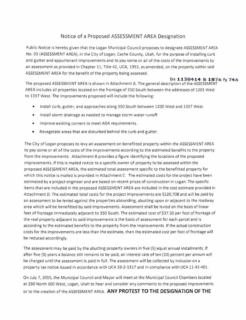

CACHE VALLEY PUBLISHING CO ISJ PAYMENT PROCESSING CENTER
PO BOX 1570 POCATELLO ID 83204
(435)752-2121
ORDER CONFIRMATION
Salesperson Jaime Maw Printed at 060115 0837 by jma13
Acct 180841 Ad 1293195 Status N
LOGAN CITY LEGAL Start 06022015 Stop 06232015 290 NORTH 100 WEST Times Ord 4 Times Run LOGAN UT 84321 LEGL 200 X 8200 Words 666
Total LEGL 16400 Class 0006 GOVERNMENT NOTICES Rate LG Cost 63412 Affidavits 1
Contact Ad Descrpt TERESSA HARRIS Phone (435)716-9797 Given by Fax (435)716-9797 Created jma13 060115 0823 Email lorimathysloganutahorg Last Changed jma13 060115 0834 Agency
PUB ZONE ED TP START INS STOP SMTWTFS HJ A 97 S 0602091623
Ent 1138414 Ok 1 876 PC) 751WEB A 97 S 0602091623
AUTHORIZATION
Under this agreement rates are subject to change with 30 days notice In the event of a cancellation before schedule completion I understand that the rate charged will be based upon the rate for the number of insertions used
Name (print or type) Name (signature)
(CONTINUED ON NEXT PAGE)
CACHE VALLEY PUBLISHING CO ISJ PAYMENT PROCESSING CENTER
PO BOX 1570 POCATELLO ID 83204
(435)752-2121
ORDER CONFIRMATION (CONTINUED)
Salesperson Jaime Maw Printed at 060115 0837 by jma13
Acct 180841
Notice of a Proposed ASSESSMENT AREA Designation
Public Notice is hereby given that the Logan Municipal Council proposes to designate ASSESSMENT AREA No 03 (ASSESSMENT AREA) in the City of Logan Cache County Utah for the purpose of installing curb and gutter and appurtenant improvements and to pay some or all of the costs of the improvements by an assessment as provided in Chapter II Tille 42 UCA 1953 as amended on the property within said ASSESSMENT AREA for the benefit of the property being assessed
The general description of the ASSESSMENT AREA includes all properties located on the frontage of 350 South between the addresses of 1203 West to 1337 West The improvements proposed will include the tollowing
Install curb gulter and approaches along 350 South between 1200 West and 1337 West Install curb gulter and approaches where applicable along the west side of 1200 West for the corner parcels Install stonn drainage as needed to manage storm water runoH in the intersection of 1200 West and 350 South tmprove eXisting intersection corners to meet ADA requirements Restore areas that are disturbed behind the curb and gutter
The City of Logan proposes to tevy an assessment on benefilted property within the ASSESSMENT AREA to pay some of the costs of the improvements according to the estimated benefits to the property from the improvements The estimated costs for the project have been estimated by a project engineer and are based on recent prices of construction in Logan The estimated total costs for the project improvements are $120708 and a portion will be paid by an assessment to be levied against the properties abounding abutting upon or adjacent to the roadway area which will be benefitted by said improvements Assessment shall be levied on the basis of linear feet of frontage immediately adjacent to 350 South The City of Logan will pay 50 of the estimated total costs for the project The estimated cost of $3750 per foot of frontage of the real property adjacent to said improvements is the basis of assessment for each parcel and is according to the estimated benetits to the property from the improvements If the actual construction costs for the improvements are less than the estimate then the estimated cost per toot of frontage will be reduced accordingly
The assessment may be paid by the abutting property owners in live (5) equal annual Installments If aller five (5) years a balance still remains to be paid an interest rate 01 one and one-hall (15) percent per annum will be charged until the assessment is paid in full The assessment will be collected by inclusion on a property lax notice issued in accordance with UCA 59-2-1317 and in compliance with UCA 11-42-401
On July 7 2015 the Municipal Council and Mayor will meet at the Municipal CounCil Chambers located at 290 North 100 West Logan Utah to hear and consider any comments to the proposed improvements or to the creation of the ASSESSMENT AREA ANY PROTEST TO THE DESIGNATION OF THE ASSESSMENT AREA OR TO BEING ASSESSED FOR THE PROPOSESED IMPROVEMENTS OPERATION AND MAINTENANCE COSTS MUST BE FILED IN WRITING Any protests to the proposed ASSESSMENT AREA shall be in writing and signed by the owner or owners 01 the property that is proposed to be assessed and who does not want the property to be included in the ASSESSMENT AREA The written protest shall contain a description 01 the ownerslY property (lot block address etc) and shall be filed with the City Recorder Logan City Offices 290 North tOO West Logan Utah on or before 500 pm on September 8 2015 The creation 01 the ASSESSMENT AREA shall be abandoned if the necessary number 01 protests has been timely filed The necessary number of protests means protests representing at least forty percent (40) 01 the linear Irontage of all the property to be assessed
Teresa Harris Logan City Recorder Publication Dates June 2 June 9 June 16 and June 23 2015
Ad 1293195 Status N
Ent 1138414 Bk 1876 Pg 752
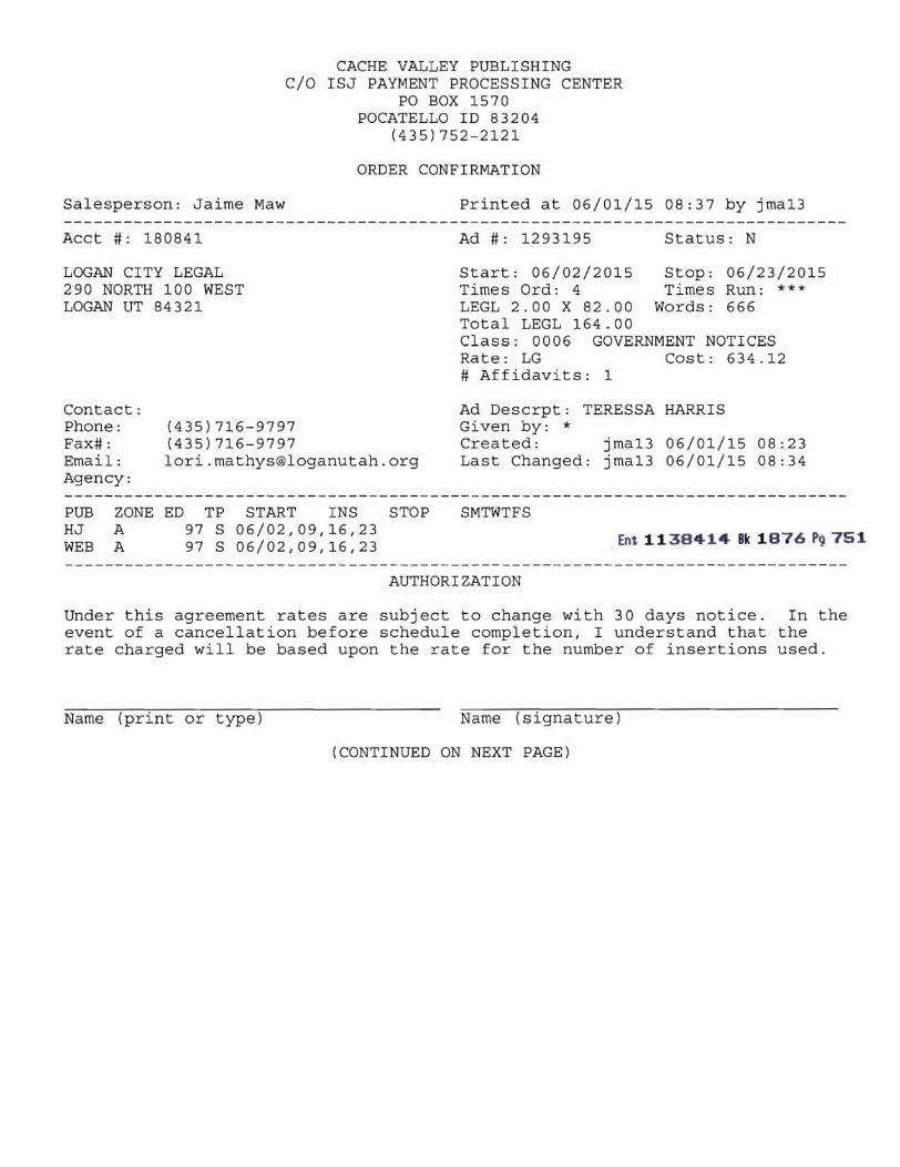
CACHE VALLEY PUBLISHING CO ISJ PAYMENT PROCESSING CENTER
PO BOX 1570 POCATELLO ID 83204
(435)752-2121
ORDER CONFIRMATION (CONTINUED)
Salesperson Jaime Maw Printed at 060115 0837 by jma13
Acct 180841
Notice of a Proposed ASSESSMENT AREA Designation
Public Notice is hereby given that the Logan Municipal Council proposes to designate ASSESSMENT AREA No 03 (ASSESSMENT AREA) in the City of Logan Cache County Utah for the purpose of installing curb and gutter and appurtenant improvements and to pay some or all of the costs of the improvements by an assessment as provided in Chapter II Tille 42 UCA 1953 as amended on the property within said ASSESSMENT AREA for the benefit of the property being assessed
The general description of the ASSESSMENT AREA includes all properties located on the frontage of 350 South between the addresses of 1203 West to 1337 West The improvements proposed will include the tollowing
Install curb gulter and approaches along 350 South between 1200 West and 1337 West Install curb gulter and approaches where applicable along the west side of 1200 West for the corner parcels Install stonn drainage as needed to manage storm water runoH in the intersection of 1200 West and 350 South tmprove eXisting intersection corners to meet ADA requirements Restore areas that are disturbed behind the curb and gutter
The City of Logan proposes to tevy an assessment on benefilted property within the ASSESSMENT AREA to pay some of the costs of the improvements according to the estimated benefits to the property from the improvements The estimated costs for the project have been estimated by a project engineer and are based on recent prices of construction in Logan The estimated total costs for the project improvements are $120708 and a portion will be paid by an assessment to be levied against the properties abounding abutting upon or adjacent to the roadway area which will be benefitted by said improvements Assessment shall be levied on the basis of linear feet of frontage immediately adjacent to 350 South The City of Logan will pay 50 of the estimated total costs for the project The estimated cost of $3750 per foot of frontage of the real property adjacent to said improvements is the basis of assessment for each parcel and is according to the estimated benetits to the property from the improvements If the actual construction costs for the improvements are less than the estimate then the estimated cost per toot of frontage will be reduced accordingly
The assessment may be paid by the abutting property owners in live (5) equal annual Installments If aller five (5) years a balance still remains to be paid an interest rate 01 one and one-hall (15) percent per annum will be charged until the assessment is paid in full The assessment will be collected by inclusion on a property lax notice issued in accordance with UCA 59-2-1317 and in compliance with UCA 11-42-401
On July 7 2015 the Municipal Council and Mayor will meet at the Municipal CounCil Chambers located at 290 North 100 West Logan Utah to hear and consider any comments to the proposed improvements or to the creation of the ASSESSMENT AREA ANY PROTEST TO THE DESIGNATION OF THE ASSESSMENT AREA OR TO BEING ASSESSED FOR THE PROPOSESED IMPROVEMENTS OPERATION AND MAINTENANCE COSTS MUST BE FILED IN WRITING Any protests to the proposed ASSESSMENT AREA shall be in writing and signed by the owner or owners 01 the property that is proposed to be assessed and who does not want the property to be included in the ASSESSMENT AREA The written protest shall contain a description 01 the ownerslY property (lot block address etc) and shall be filed with the City Recorder Logan City Offices 290 North tOO West Logan Utah on or before 500 pm on September 8 2015 The creation 01 the ASSESSMENT AREA shall be abandoned if the necessary number 01 protests has been timely filed The necessary number of protests means protests representing at least forty percent (40) 01 the linear Irontage of all the property to be assessed
Teresa Harris Logan City Recorder Publication Dates June 2 June 9 June 16 and June 23 2015
Ad 1293195 Status N
Ent 1138414 Bk 1876 Pg 752