-m.;; TIN DEPOSITS OF THE SOUTH WEST - mrt.tas.gov.au · TIN DEPOSITS OF THE SOUTH WEST ... feet...
8
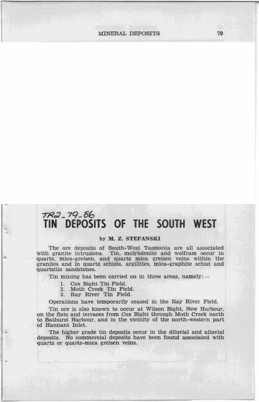
A • MINERAL DEPOSITS 79 -m.;; _ 79_86 TIN DEPOSITS OF THE SOUTH WEST by M. Z. STEFANSKI The ore deposits of SOuth· West Tasmania are all associated with granite intrusions. Tin, molybdenite and wolfram occur in quartz, mica- greisen, and Quartz mica greisen veins within the granites and in quartz schists, argillites, mica-graphite schist and quartzitic sandstones. Tin mining has been carried on in three areas. namely: - 1. Cox Bight Tin Field. 2. Moth Creek Tin Field. 3. Ray River Tin Field. Operations have temporarily ceased in the Ray River Field. Tin Ofe is also known to occur at Wilson Bight, New Harbour, on the fiats and terraces from Cox Bight through Moth Creek north to Bathurst Harbour, and in the vicinity of the north-western part ()f Hannant Inlet. The highe r grade tin deposits occur in the dlluvial and alluvial deposits. No commercial deposits have been found associated with quartz or quartz-mica greisen veins .
Transcript of -m.;; TIN DEPOSITS OF THE SOUTH WEST - mrt.tas.gov.au · TIN DEPOSITS OF THE SOUTH WEST ... feet...
~
~
A
•
MINERAL DEPOSITS 79
-m.;; _ 79_86 TIN DEPOSITS OF THE SOUTH WEST
by M. Z. STEFANSKI
The ore deposits of SOuth· West Tasmania are all associated with granite intrusions. Tin, molybdenite and wolfram occur in quartz, mica-greisen, and Quartz mica greisen veins within the granites and in quartz schists, argillites, mica-graphite schist and quartzitic sandstones.
Tin mining has been carried on in three areas. namely: -1. Cox Bight Tin Field. 2. Moth Creek Tin Field. 3. Ray River Tin Field.
Operations have temporarily ceased in the Ray River Field. Tin Ofe is also known to occur at Wilson Bight, New Harbour,
on the fiats and terraces from Cox Bight through Moth Creek north to Bathurst Harbour, and in the vicinity of the north-western part ()f Hannant Inlet.
The higher grade tin deposits occur in the dlluvial and alluvial deposits. No commercial deposits have been found associated with quartz or quartz-mica greisen veins .
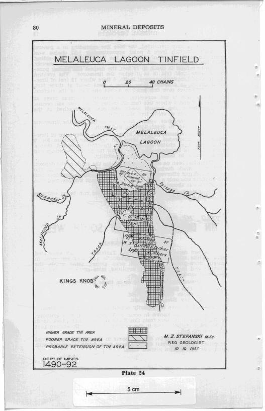
80 MINERAL DEPOSITS
MELALEUCA LAGOON TINFIELD
o 20 40 CHAINS , , ,
I' MELALEUCA I
KINGS KN08~~ ~ "".l
Hlt;IER GRAD£ TIN AR£A
POORER GRADE TIN AREA
PROBABLE EXT~NSION OF TIN AREA.
DE PT OF MINE S
1490-92
l!!mI!l cs::::s:J t:=:J
Plate 24
~ Scm
~I 1
M. Z. STEFANSKI N.SC'. REG GEOLOGIST
10 ( Q 1957
.-j
•
..

~
•
•
•
MINERAL DEPOSITS 81
During recent years these areas have been examined and the writer in general agrees with the conclusion of the earlier jnvestigators Messrs. P. B. Nye and A. McIntosh Reid.
Mr. Lark Macquarle of Hobart, in the year 1891, discovered tin ore near the neck of Pt. Eric at Cox Bight. His discovery attracted prospectors Robert Glover and W. H . Foley from Port Davey. These men were granted Reward Sections on the western side of Pt. Eric in September, 1892. The leases were transferred to Glover and Foley Pty. in the year ] 893.
Under various proprietors operations continued spasmodically tin the year 1930. Later attempts have been made, unsuccessfully. to re-open the field. At present one maD is operating on the field with some success.
The Cox Bight Tin Field has been described by three Government Geologists, namely by W. H. Twelvetrees-Report on Cox Bight Tin Field- 5th December. 1906; P . B. Nye- Report on Geological Survey of Port Davey District-28th March, 1928; and by A. McIntosh Reid- Report on Cox Bight Tin Field- 22nd May. 1928. From these reports detailed information is available and has been recorded on the plan accompanying this report.
Cox Bight tin field lies along the mid-southern cOj.st of Tasmania and is approximately four miles in length and three-Quarters to one mile in width. There is a geographical diviSion of the tin field into an eastern and western area. The Cox Bight tin field is connected with Melaleuca Inlet by a track, eight miles long, over a button-grass plain. On its eastern side at Boat Harbour it is accessible for small fishing boats, during calm weather only. Both beaches, the eastern one and the western one, are suitable for the landing of small aircraft. During the dry season, Cox Bight could be successfully connected with MelaJeuca Inlet by a caterpillar type of vehicle (bren-gun carrier).
The Cox Bight tin field extends over an old Uttoral and a low plateau (fluvio glacial zone) on the eastern side of Pt. Eric. The littoral is bounded on the sea-side by high sand dunes and on the other sides by steeply sloping hills and mountains of granite. quartzite and Quartz-schists, giving the appearance of a natural amphitheatre. One prominent peak, Foleys Pimple, rises to 1175 feet above sea-level. Except for the gullies. the country is devoid of trees and presents a barren appearance.
The predominant rocks of the area are quartz schists and Quartzites of Precambrian age with granites of probable Devonian age. All these formations contain Quartz veins and veinlets, many of them mineralised. Minor formations are the Pleistocene gravels and boulders of the eastern Cox Bight plateau and the plains between the granites and the New Harbour Range. These gravels and boulders generally form plateaux or terraces very often up to 30 feet in thickness.
The principal mineral of the Cox Bight area is cassiterite. deposited in dlluvlals and alluvials on either side of the granites. I.e., on the south-western and south-eastern sides (see map). It is reported also, that small amounts of cassiterite occur in several places in quartz veins but give way to pyrites at shallow depths.

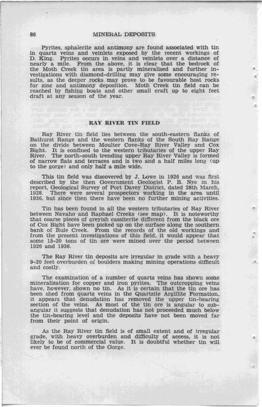
82 MINERAL DEPOSITS
RAY RIVER TINFIELD
o 20 40 CHAINS
:\\\\ " "~ . " ~ A ~ LEES KNOB 'l/t~ .. ,\~
HIGHER ~ADE 7TH AREA
! , !
I!mm pOORER GRADE TIN AREA r::s::::sJ PROfJ.ABLE EXTENS/ON OF' 71N AREAc=:J
CEPT OF MINES
1488-92 Plate 25
~ S cm
.>i
,,"''' -~ -= . . ~t •• ··'"
AI. Z. SrEFANSKI M.Sc.
REG. GEOLOGI ST
10·/0 · 1957
.-J
• c
.,
., .' .
"

-
..
• •
•
" .
MINERAL DEPOSITS 83
There are two types of tin deposits; the littoral, and the plateau. The south-western tin deposits are mainly littoral. The south· eastern are littoral ones along the sea-shore over 10 chains wide and 50 chains in length. The plateau or terrace deposits. the northeastern ones, are nearly 100 chains in length, and extend along Cox Creek in a south-west direction. Low-grade tin ore also occurs along Pender's Creek. According to W. H. Twelvetrees' report. 5th December. 1906, some 200 tons of tin concentrates of 70-75 % grade. have been removed during 1891-1906.
Together with cassiterite, molybdenite and wolfram have been found in small Quartz veins in the granite and quartz schists of Meldon Creek, Knight Creek and Pender Creek areas.
To a limited extent exploitation of the .. plateau" deposits, along Knight, Meldon. Dutchman and Goring Creeks has taken place. It is assumed that conditions for deposition and concentration of tin in the littoral beds are favourable. In 1913, an attempt was made by Church to explore the littoral beds by sinking shafts and drilling holes to the bed rock (see map and McIntosh Reid Report ). Although a great amount of work of a confirmatory and exploratory character has been performed by prospectors and companies like the Tin Operations Ltd. of Melbourne by their engineer, Roburg (see map), no effective work has been carrIed out since Church's time <1913>'
Many prospecting shafts have been sunk in the littorals and plains as well as the plateau of the eastern part of Cox Bight. From a compilation of the P. B. Nye and McIntosh-Reid reports and 'my own observations and surveys done in the country, a map of the Cox Bight tin field has been produced showing the approximate extent of tin areas and the locations of the shafts and bore-holes made by Church and Roburg.
Summa'ry
From my own observations and those of P. B. Nye and McIntosh-Reid on Cox Bight it is obvious that the plateau and terraces area is valuable in parts. but as a whole is poor nnd not worthy of the attention of a company.
It seems, therefore. that the littoral diluvial and alluvial deposits. covering an area of about 200 acres, are the only assets of potential value. but these have been only partly explored. The depth of tin are varies from 20 to 40 feet and it is usaully contained in the lower boulder wash. where the boulders are not larger than 12 inches.
Although the wash is fttmly cemented it disintegrates easily under the nozzle or pick. It is very unlikely that Weber Lagoon will contain tin ore of commercial value. For dredging operations. the critical value should be approximately 0·5 lb. per cubic yard. There should be high-grade tin ore along lower runs of Knight. Meldon and Dutchman Creeks on the south-western side and along littoral runs of Goring, Ball and Cox-Freney Creeks on the southeastern side of Cox Bight.
Factors adverse to possible mining operations in the area would be the isolated location. the high cost of transport and, therefore, high cost of production, and the severe climatic conditions during winter,

--------(QCID ~ lI3l"'1llV3 JO S.1.:M-5" nmmm"------s.wwnJ.3liIlY"J • 2JIJ0I#-Y,)I" NOUWltfQ:f ~ )QX).1$Y']
..... ~'! =~:::~=~"--------- ---"",, t::;;;:l-----------------U""""''' .. ' .... NOIJ.''''''''' AVI.....,= c=:J"---------Y.NV Nil .:to ~ ~ I:CIJ-------rJI11Y.l¥l'.S.W,U¥J7'lO NOU't'loWOJ ~ 7.>ON8-AYI J.::I"t'~CO
r:s::s::::::l-"--------------~ HU 3Cl't'\r.) lGIiIOOol E::::!J-----IWIQS "JIIJ<I¥I'IO " UJlZ.I¥01IO N01J.vmtoJ :Y.>NVW ~·"'·S
~-------------v.nrv NI.L 3OV\i!) ~ p~---------------------------------------~M""NVIHO~
E o It)

~
"
•
•
" .
MINERAL DEPOSITS 85
It is possible that, as a result of future exploration, the western and eastern deep diluvial and alluvial deposits may together prove of sufficient importance to warrant some outlay for the provision of the necessary equipment for small-scale mining,
MOTH CREEK TIN FIELD
The Moth Creek tin field was discovered by B. Adams and A. Evendon in the years 1934-35. In 1935 a company was floated under the name .. New Harbour Tin Company". After two years, Mr. Brock took over the Company's leases, but a few months later surrendered them. In 1938. Hollingsworth took the leases, bought new machinery and worked for nearly two years. During 1941, Hollingsworth handed over the leases to C. G. King and R. Young.
The alluvial and diluvial tin deposits are bounded approximately by Moth Creek on the east, Melaleuca Lagoon on the north and Melaleuca Creek on the north-west (see map), the area being about one and a half miles long and varying in width from about half a mile at the northern end to a quarter of a mile at the southern end.
At present. the major part of the above tin field is leased to R. Young (80 acres) . C. G. King (80 acres). W. 8. King (40 acres) a nd D. Dicker (40 acres).
The tin here is associated with fine monazite. Tin. monazite and copper pyrites occur together in an old shaft close to King's present workings. Another outcrop of tin and monazite occurs in a quartz veinlet in a sluice box cutting, close to the King's old tractor shed. As quartz veins carrying appreCiable amounts of tin have not been found and as the cassiterite crystals are angular and sub-angular, it is suggested that the tin in quartz veins had only a very limited vertical extent and the ore is close to it.o<: origin.
Most of the tin has been worked and is still worked at shallow depths, although some deeper mining has been. and should, in the near future, be undertaken since high-grade tin ore is obtainable. Most shallow ground on the 80 acres C. G. King lease has been worked out already. Official Mines Department statistics from 1934-35 till 1956. show that a total of 58 tons of metallic tin worth £822,390 has been produced.
It is estimated that the area containing high-grade are jn the Moth Creek tin field will contain at least 60 tons of metallic tin. The greater proportion of this ore will occur in the deeper ground. During the period from 1934-35 till 1956 an average of three men have been employed although as many as 19 have been employed (in 1936) . It is assumed that the high-grade tin area has an average of 1-3 ozs. of tin per dish.
D. King used a small bulldozer for his tin exploitation over shallow ground with up to four feet overburden. To exploit the deeper ground a gravel pump is necessary as a lot deeper ground is below sea-level.
Water for tin sluicing can be collected locally during the wet season (from May till November) or pumped through pipes from Moth Creek or Melaleuca River in any season.
•
86 MINERAL DEPOSITS
Pyrites, sphalerite and antimony are found associated with tin in quartz veins and veinlets exposed by the recent workings of D. King. Pyrites occurs in veins and veinlets over a distance of nearly a mile. From the above, it is clear that the bedrock of the Moth Creek tin area is partly mineralised and further investigations with diamond-drilling may give some encouraging results, as the deeper rocks may prove to be favourable host rocks for zinc and antimony deposition. Moth Creek tin field can be reached by fishing boats and other small craft up to eight feet draft at any season of the year.
RAY RIVER TIN FIELD
Ray River tin field lies between the south-eastern .flanks of Bathurst Range and the western flanks of the South Ray Range on the divide between Moulter Cove-Ray River Valley and Cox Bight. It is confined to the western tributaries of the upper Ray River. The north-south trending upper Ray River Valley is formed of narrow flats and terraces and Is two and a half miles long (up to the gorge) and only half a mile wide.
This tin field was discovered by J. Lowe in 1926 and was first described by the then Government Geologist P. B. Nye in his report, Geological Survey of Port Davey District, dated 28th March, 1928. There were several prospectors working in the area until 1936. but since then there have been no further mining activities.
Tin has been found in all the western tributaries of Ray River between Navaho and Raphael Creeks (see map). It is noteworthy that coarse pieces of greyish cassiterite different from the black are of Cox Bight have been picked up on the surface along the southern bank of Rule Creek. From the records of the old workings and from the present investigations of this field, it would appe3r that some 15-20 tons of tin are were mined over the period between 1926 and 1936.
The Ray River tin deposits are irregular in grade with a heavy 9-20 feet overburden oi boulders making mining operations difficult and costly.
The examination of a number of quartz veins has shown some mineralizat10n for copper and iron pyrites. The outcropping ve1ns have. however. shown no tin. As it is certain that the tin ore has been shed from quartz veins in the Quartzite Argillite Formation. it appears that denudation has removed the upper tin-bearing section of the veins. As most of the tin are Is angular to subangular it suggests that denudation has not proceeded much below the tin-bearing level and the deposits have not been moved far from their point of origin.
As the Ray River tin field is of small extent and of irregular grade, with heavy overburden and difficulty of access, it is not likely to be of commercial value. It is doubtful whether tin will ever be found north of the Gorge.
• •
..
o
•
•
•
;