[ Feet - No CapX 2020 · GaD FaC HnF HnF FaD2 FaD2 HuA FaD2 FaD2 FaD2 GoD2 EoE Lx FaB DoC2 BmA HnF...
31
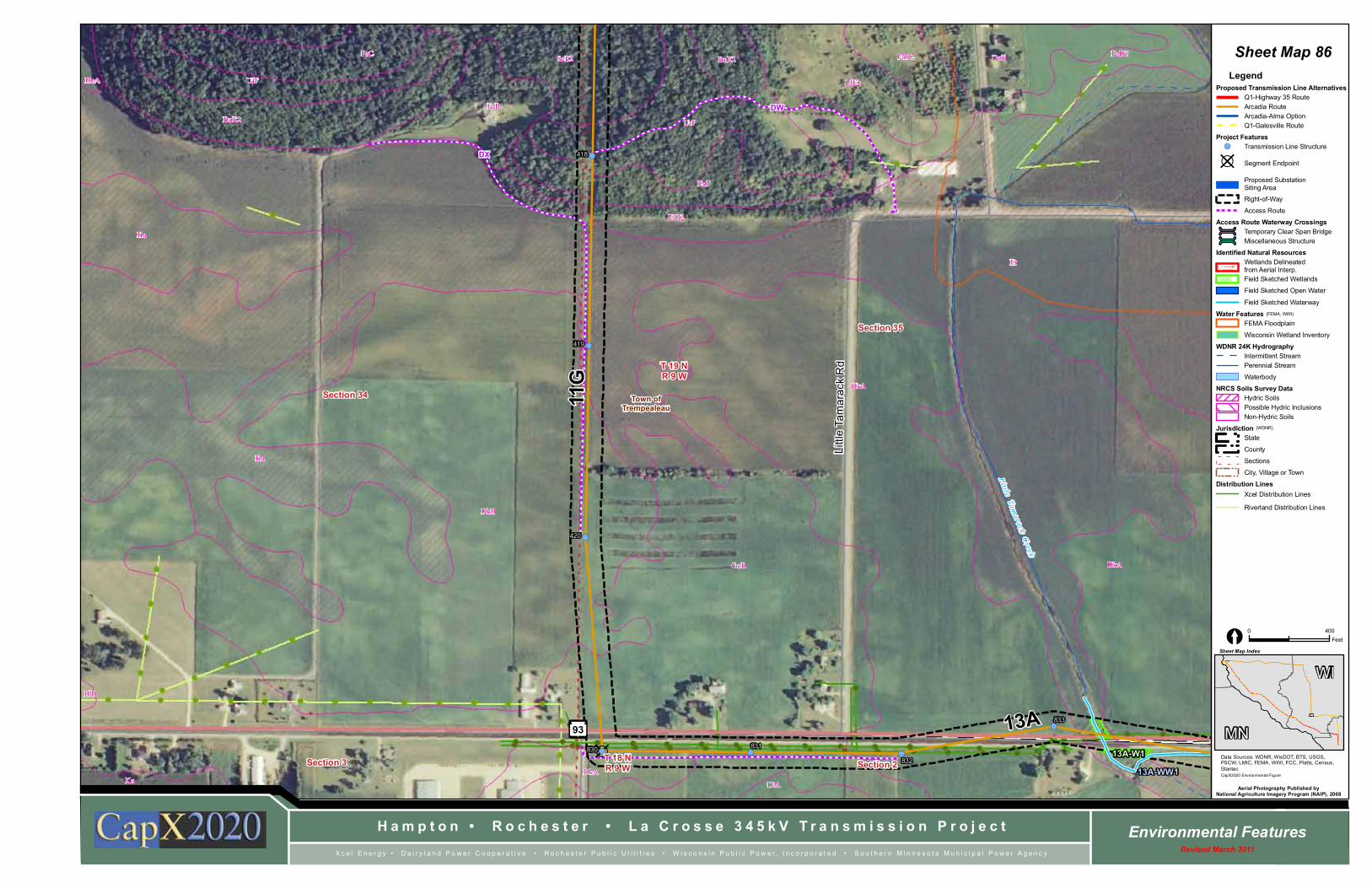
? D ! ( ! ( ! ( ! ( ! ( ! ( ! ( Li tt l e T a m a r a c k Cr e e k EnF ElD2 SpB DlA DkA Ka UrF BlB GoB DkA Ka DkB DkA Ka FaD3 BnE2 UfF FaB Et HuA LfE2 FaD2 SeE2 DoB FaC BnE2 L i t t l e T a m a r a c k R d 93 Section 2 Section 35 Section 34 Section 3 T 18 N R 9 W T 19 N R 9 W Town of Trempealeau 13A 11G DX DW 420 419 418 833 832 831 830 13A-W1 13A-WW1 Hampton • Rochester • La Crosse 345kV Transmission Project Environmental Features Revised March 2011 Xcel Energy • Dairyland Power Cooperative • Rochester Public Utilities • Wisconsin Public Power, Incorporated • Southern Minnesota Municipal Power Agency Data Sources: WDNR, WisDOT, BTS, USGS, PSCW, LMIC, FEMA, WWI, FCC, Platts, Census, Stantec CapX2020 Environmental Figure Sheet Map Index Aerial Photography Published by National Agriculture Imagery Program (NAIP), 2008 0 400 Feet [ Sheet Map 86 WI MN Legend Proposed Transmission Line Alternatives Q1-Highway 35 Route Arcadia Route Arcadia-Alma Option Q1-Galesville Route Project Features ! ( Transmission Line Structure ? D Segment Endpoint Proposed Substation Siting Area Right-of-Way Access Route Access Route Waterway Crossings ú Temporary Clear Span Bridge ú Miscellaneous Structure Identified Natural Resources Wetlands Delineated from Aerial Interp. Field Sketched Wetlands Field Sketched Open Water Field Sketched Waterway Water Features FEMA Floodplain Wisconsin Wetland Inventory WDNR 24K Hydrography Intermittent Stream Perennial Stream Waterbody NRCS Soils Survey Data Hydric Soils Possible Hydric Inclusions Non-Hydric Soils Jurisdiction State County Sections City, Village or Town Distribution Lines Xcel Distribution Lines Riverland Distribution Lines (FEMA, WWI) (WDNR)
-
Upload
nguyenngoc -
Category
Documents
-
view
223 -
download
0
Transcript of [ Feet - No CapX 2020 · GaD FaC HnF HnF FaD2 FaD2 HuA FaD2 FaD2 FaD2 GoD2 EoE Lx FaB DoC2 BmA HnF...
?D!( !( !(
!(
!(
!(
!(
Litt le Tam
a rack C
reek
EnF
ElD2
SpBDlA
DkAKa
UrF
BlB
GoB DkA
Ka
DkB
DkA
Ka
FaD3
BnE2
UfF
FaB
Et
HuA LfE2
FaD2SeE2 DoBFaCBnE2
Lit tl
e T a
mar
ack
Rd
93
Section 2
Section 35
Section 34
Section 3 T 18 NR 9 W
T 19 NR 9 W
Town ofTrempealeau
13A
11G
DX
DW
420
419
418
833
832
831830 13A-W1
13A-WW1
H a m p t o n • R o c h e s t e r • L a C r o s s e 3 4 5 k V T r a n s m i s s i o n P r o j e c t Environmental FeaturesRevised March 2011X c e l E n e r g y • D a i r y l a n d P o w e r C o o p e r a t i v e • R o c h e s t e r P u b l i c U t i l i t i e s • W i s c o n s i n P u b l i c P o w e r , I n c o r p o r a t e d • S o u t h e r n M i n n e s o t a M u n i c i p a l P o w e r A g e n c y
Data Sources: WDNR, WisDOT, BTS, USGS,PSCW, LMIC, FEMA, WWI, FCC, Platts, Census,StantecCapX2020 Environmental Figure
Sheet Map Index
Aerial Photography Published byNational Agriculture Imagery Program (NAIP), 2008
0 400Feet[
Sheet Map 86
WI
MN
LegendProposed Transmission Line Alternatives
Q1-Highway 35 RouteArcadia RouteArcadia-Alma OptionQ1-Galesville Route
Project Features!( Transmission Line Structure
?D Segment Endpoint
Proposed SubstationSiting Area
Right-of-Way
Access Route
Access Route Waterway Crossingsú Temporary Clear Span Bridgeú Miscellaneous Structure
Identified Natural ResourcesWetlands Delineatedfrom Aerial Interp.Field Sketched Wetlands
Field Sketched Open Water
Field Sketched Waterway
Water FeaturesFEMA Floodplain
Wisconsin Wetland Inventory
WDNR 24K HydrographyIntermittent StreamPerennial Stream
Waterbody
NRCS Soils Survey DataHydric SoilsPossible Hydric InclusionsNon-Hydric Soils
JurisdictionState
County
Sections
City, Village or Town
Distribution LinesXcel Distribution Lines
Riverland Distribution Lines
(FEMA, WWI)
(WDNR)

?D!( !( !( !( !(
!(
!(
Litt le Tam
a rack C
reek
FaE
PoA
BlBDlA
FaD
GoB
BlA
DlA
GoBDkB
DkA
DkB
DlA
DkA
DkB
Et
HnF
DkA
DkB
DkA
BnE2
GoB
93
Section 35
Section 34
Section 2Section 3
T 18 NR 9 W
T 19 NR 9 W
Town ofTrempealeau
11G
13A831
420
833
835
834832
830 13A-W1
13A-WW113A-WW2
H a m p t o n • R o c h e s t e r • L a C r o s s e 3 4 5 k V T r a n s m i s s i o n P r o j e c t Environmental FeaturesRevised March 2011X c e l E n e r g y • D a i r y l a n d P o w e r C o o p e r a t i v e • R o c h e s t e r P u b l i c U t i l i t i e s • W i s c o n s i n P u b l i c P o w e r , I n c o r p o r a t e d • S o u t h e r n M i n n e s o t a M u n i c i p a l P o w e r A g e n c y
Data Sources: WDNR, WisDOT, BTS, USGS,PSCW, LMIC, FEMA, WWI, FCC, Platts, Census,StantecCapX2020 Environmental Figure
Sheet Map Index
Aerial Photography Published byNational Agriculture Imagery Program (NAIP), 2008
0 400Feet[
Sheet Map 87
WI
MN
LegendProposed Transmission Line Alternatives
Q1-Highway 35 RouteArcadia RouteArcadia-Alma OptionQ1-Galesville Route
Project Features!( Transmission Line Structure
?D Segment Endpoint
Proposed SubstationSiting Area
Right-of-Way
Access Route
Access Route Waterway Crossingsú Temporary Clear Span Bridgeú Miscellaneous Structure
Identified Natural ResourcesWetlands Delineatedfrom Aerial Interp.Field Sketched Wetlands
Field Sketched Open Water
Field Sketched Waterway
Water FeaturesFEMA Floodplain
Wisconsin Wetland Inventory
WDNR 24K HydrographyIntermittent StreamPerennial Stream
Waterbody
NRCS Soils Survey DataHydric SoilsPossible Hydric InclusionsNon-Hydric Soils
JurisdictionState
County
Sections
City, Village or Town
Distribution LinesXcel Distribution Lines
Riverland Distribution Lines
(FEMA, WWI)
(WDNR)

?D
?D
!(
!(
!(!(
!( !(
!(
!(
!(
!(
Li tt le Tamarack Creek
FaD
LfE
FaD3
LfE
SeEHnF
FaC2
SeB
PoA
DoBSrA
DkB
BnE2SeD2
DkB
BlB
GoB
BlA
GoB
DlA
Et
HnF
FaB
FaD2
DkA
DkA
BnE2
FaD2
WoABnE2
FaE
BlC2
FaD
93
Section 2Section 1
Section 35Section 36
T 18 NR 9 W
T 19 NR 9 W
Town ofCaledonia
Town ofGale
Town ofTrempealeau
13A
12
13B113B2
627
628841
836 837
838
839
840
626
13B1-FW1
13A-WW2
13A-WW2
H a m p t o n • R o c h e s t e r • L a C r o s s e 3 4 5 k V T r a n s m i s s i o n P r o j e c t Environmental FeaturesRevised March 2011X c e l E n e r g y • D a i r y l a n d P o w e r C o o p e r a t i v e • R o c h e s t e r P u b l i c U t i l i t i e s • W i s c o n s i n P u b l i c P o w e r , I n c o r p o r a t e d • S o u t h e r n M i n n e s o t a M u n i c i p a l P o w e r A g e n c y
Data Sources: WDNR, WisDOT, BTS, USGS,PSCW, LMIC, FEMA, WWI, FCC, Platts, Census,StantecCapX2020 Environmental Figure
Sheet Map Index
Aerial Photography Published byNational Agriculture Imagery Program (NAIP), 2008
0 400Feet[
Sheet Map 88
WI
MN
LegendProposed Transmission Line Alternatives
Q1-Highway 35 RouteArcadia RouteArcadia-Alma OptionQ1-Galesville Route
Project Features!( Transmission Line Structure
?D Segment Endpoint
Proposed SubstationSiting Area
Right-of-Way
Access Route
Access Route Waterway Crossingsú Temporary Clear Span Bridgeú Miscellaneous Structure
Identified Natural ResourcesWetlands Delineatedfrom Aerial Interp.Field Sketched Wetlands
Field Sketched Open Water
Field Sketched Waterway
Water FeaturesFEMA Floodplain
Wisconsin Wetland Inventory
WDNR 24K HydrographyIntermittent StreamPerennial Stream
Waterbody
NRCS Soils Survey DataHydric SoilsPossible Hydric InclusionsNon-Hydric Soils
JurisdictionState
County
Sections
City, Village or Town
Distribution LinesXcel Distribution Lines
Riverland Distribution Lines
(FEMA, WWI)
(WDNR)

!(
!(
!(
!(
!(
!(
!(
!(
!(
!(
!(
!(
!(
!(
!(
!(
Little Tamarack Creek
Er
Er
MuA
FaD
FaE
DoC2
FaD3
PoC2
SeE
DoB
FaC2
PoB
HnF
FaC2
DoBBlC2
PoB
DoB
Lx
SeD2
Gu
BlBDkB
SpB
GoB
BlA
GoB DkB
Sd
EoE
Lv
FaD2DoA
DoB
Lx
FaD2
HuA
FaD2
FaB
FaD2
EoE
Er
DoB
FaC
DkA
DoB
93
Section 31
Section 36
Section 6
Section 1
T 18 NR 8 W
T 18 NR 9 W
T 19 NR 8 W
T 19 NR 9 W
Town ofTrempealeau
Town ofGale
13B2
13B2
843
844
842
849
848
847
846
845
13B2-FW1
13B1-FW1
13B2-WW1
H a m p t o n • R o c h e s t e r • L a C r o s s e 3 4 5 k V T r a n s m i s s i o n P r o j e c t Environmental FeaturesRevised March 2011X c e l E n e r g y • D a i r y l a n d P o w e r C o o p e r a t i v e • R o c h e s t e r P u b l i c U t i l i t i e s • W i s c o n s i n P u b l i c P o w e r , I n c o r p o r a t e d • S o u t h e r n M i n n e s o t a M u n i c i p a l P o w e r A g e n c y
Data Sources: WDNR, WisDOT, BTS, USGS,PSCW, LMIC, FEMA, WWI, FCC, Platts, Census,StantecCapX2020 Environmental Figure
Sheet Map Index
Aerial Photography Published byNational Agriculture Imagery Program (NAIP), 2008
0 400Feet[
Sheet Map 89
WI
MN
LegendProposed Transmission Line Alternatives
Q1-Highway 35 RouteArcadia RouteArcadia-Alma OptionQ1-Galesville Route
Project Features!( Transmission Line Structure
?D Segment Endpoint
Proposed SubstationSiting Area
Right-of-Way
Access Route
Access Route Waterway Crossingsú Temporary Clear Span Bridgeú Miscellaneous Structure
Identified Natural ResourcesWetlands Delineatedfrom Aerial Interp.Field Sketched Wetlands
Field Sketched Open Water
Field Sketched Waterway
Water FeaturesFEMA Floodplain
Wisconsin Wetland Inventory
WDNR 24K HydrographyIntermittent StreamPerennial Stream
Waterbody
NRCS Soils Survey DataHydric SoilsPossible Hydric InclusionsNon-Hydric Soils
JurisdictionState
County
Sections
City, Village or Town
Distribution LinesXcel Distribution Lines
Riverland Distribution Lines
(FEMA, WWI)
(WDNR)

ú
!(
!(
!(
!(!(
!(
!(
!(
!(
!(
!(!(
!(
!(
W
BlC2
GoA
GoB
Lx
BnE2 BlB
FaC2
GoB BlB
HnF
DoB
HuA
Er
DoB
FaD2
FaD2
HuA
GoD2DoB
BnC2
BlB
LsA
DoBDoA
Er
HuA
BlB
Lv
GoC
We
Lx
Lv
BlB
Pa
W
DoB
FaD2
DoB
Lx
Sd
Er
FaC2
Ho
EoE
SrA
DoA
BlB
FaDPa
93
Section 32
Section 31
T 19 NR 8 W
B e a v e r C r e e k
Un
na
me d E2K
E2Kg
S3/E2K
E2K
E2Kg
Town ofGale
City ofGalesville
13B2850 851
852853
854
849
855
13B-WW3
13B2-FW213B2-FW2
13B2-W1
13B2-WW2
H a m p t o n • R o c h e s t e r • L a C r o s s e 3 4 5 k V T r a n s m i s s i o n P r o j e c t Environmental FeaturesRevised March 2011X c e l E n e r g y • D a i r y l a n d P o w e r C o o p e r a t i v e • R o c h e s t e r P u b l i c U t i l i t i e s • W i s c o n s i n P u b l i c P o w e r , I n c o r p o r a t e d • S o u t h e r n M i n n e s o t a M u n i c i p a l P o w e r A g e n c y
Data Sources: WDNR, WisDOT, BTS, USGS,PSCW, LMIC, FEMA, WWI, FCC, Platts, Census,StantecCapX2020 Environmental Figure
Sheet Map Index
Aerial Photography Published byNational Agriculture Imagery Program (NAIP), 2008
0 400Feet[
Sheet Map 90
WI
MN
LegendProposed Transmission Line Alternatives
Q1-Highway 35 RouteArcadia RouteArcadia-Alma OptionQ1-Galesville Route
Project Features!( Transmission Line Structure
?D Segment Endpoint
Proposed SubstationSiting Area
Right-of-Way
Access Route
Access Route Waterway Crossingsú Temporary Clear Span Bridgeú Miscellaneous Structure
Identified Natural ResourcesWetlands Delineatedfrom Aerial Interp.Field Sketched Wetlands
Field Sketched Open Water
Field Sketched Waterway
Water FeaturesFEMA Floodplain
Wisconsin Wetland Inventory
WDNR 24K HydrographyIntermittent StreamPerennial Stream
Waterbody
NRCS Soils Survey DataHydric SoilsPossible Hydric InclusionsNon-Hydric Soils
JurisdictionState
County
Sections
City, Village or Town
Distribution LinesXcel Distribution Lines
Riverland Distribution Lines
(FEMA, WWI)
(WDNR)

!( !(
!(
!(
!(
!(
!(
!( !(
!(
!(
!(
!(
!(
DoB
FaC
HnF
HnE2
FaC
FaC2
HnF
UrF
GaD
FaC
HnF
HnFFaD2
FaD2
HuA
FaD2
FaD2
FaD2
GoD2
EoE
FaBLx
DoC2
BmA
HnF
FaD2
BlB FaD2
FaD
Lx
BlB
W
LfE
Lx
Sd
DoC2
HnFDoD2
HuA
SrA
LfE
FaD
FaC
LfC2
GoA
GoB
Lx
DoB
GaD2
GoC
LfE2
HuA
FaC2 FaE
93
53
Section 33
Section 32
Section 4Section 5T 18 NR 8 W
T 19 NR 8 W
B e a v e r C r e ek
Town ofGale
City ofGalesville
13B2DY
862
861
860
858
857856
859
13B2-FW2
13B2-W2
H a m p t o n • R o c h e s t e r • L a C r o s s e 3 4 5 k V T r a n s m i s s i o n P r o j e c t Environmental FeaturesRevised March 2011X c e l E n e r g y • D a i r y l a n d P o w e r C o o p e r a t i v e • R o c h e s t e r P u b l i c U t i l i t i e s • W i s c o n s i n P u b l i c P o w e r , I n c o r p o r a t e d • S o u t h e r n M i n n e s o t a M u n i c i p a l P o w e r A g e n c y
Data Sources: WDNR, WisDOT, BTS, USGS,PSCW, LMIC, FEMA, WWI, FCC, Platts, Census,StantecCapX2020 Environmental Figure
Sheet Map Index
Aerial Photography Published byNational Agriculture Imagery Program (NAIP), 2008
0 400Feet[
Sheet Map 91
WI
MN
LegendProposed Transmission Line Alternatives
Q1-Highway 35 RouteArcadia RouteArcadia-Alma OptionQ1-Galesville Route
Project Features!( Transmission Line Structure
?D Segment Endpoint
Proposed SubstationSiting Area
Right-of-Way
Access Route
Access Route Waterway Crossingsú Temporary Clear Span Bridgeú Miscellaneous Structure
Identified Natural ResourcesWetlands Delineatedfrom Aerial Interp.Field Sketched Wetlands
Field Sketched Open Water
Field Sketched Waterway
Water FeaturesFEMA Floodplain
Wisconsin Wetland Inventory
WDNR 24K HydrographyIntermittent StreamPerennial Stream
Waterbody
NRCS Soils Survey DataHydric SoilsPossible Hydric InclusionsNon-Hydric Soils
JurisdictionState
County
Sections
City, Village or Town
Distribution LinesXcel Distribution Lines
Riverland Distribution Lines
(FEMA, WWI)
(WDNR)

?D
?D
!(
!(
!(
!(
!(
!(
!(
!(
!(
!(
!(
!(
!(
!(
GaC
HnF
GaD2
FaD2
FaC
FaE
GaD
HnF
FaD
EoE
FaD2
FaCGaD
FaC
FaC
FaC
DoB
FaC2FaE
DoB
EnF
BP
FaD
FaD
FaD2EoE
St
FaD2
HnE2
FaE
HnF
HnE2
DoBFaC
LfE2
HuA
FaD2
HnF
FaC2
FaD2
DoC2
FaE
FaD2
Lx
EoE
FaD
EoE
Hogden Rd
Section 4
Section 33Section 34
Section 3
T 19 NR 8 W
T 18 NR 8 W
Town ofGale
13D
13B2
13C
864
865
867
869
868
866
863
13B2-W3
13C-FW1
H a m p t o n • R o c h e s t e r • L a C r o s s e 3 4 5 k V T r a n s m i s s i o n P r o j e c t Environmental FeaturesRevised March 2011X c e l E n e r g y • D a i r y l a n d P o w e r C o o p e r a t i v e • R o c h e s t e r P u b l i c U t i l i t i e s • W i s c o n s i n P u b l i c P o w e r , I n c o r p o r a t e d • S o u t h e r n M i n n e s o t a M u n i c i p a l P o w e r A g e n c y
Data Sources: WDNR, WisDOT, BTS, USGS,PSCW, LMIC, FEMA, WWI, FCC, Platts, Census,StantecCapX2020 Environmental Figure
Sheet Map Index
Aerial Photography Published byNational Agriculture Imagery Program (NAIP), 2008
0 400Feet[
Sheet Map 92
WI
MN
LegendProposed Transmission Line Alternatives
Q1-Highway 35 RouteArcadia RouteArcadia-Alma OptionQ1-Galesville Route
Project Features!( Transmission Line Structure
?D Segment Endpoint
Proposed SubstationSiting Area
Right-of-Way
Access Route
Access Route Waterway Crossingsú Temporary Clear Span Bridgeú Miscellaneous Structure
Identified Natural ResourcesWetlands Delineatedfrom Aerial Interp.Field Sketched Wetlands
Field Sketched Open Water
Field Sketched Waterway
Water FeaturesFEMA Floodplain
Wisconsin Wetland Inventory
WDNR 24K HydrographyIntermittent StreamPerennial Stream
Waterbody
NRCS Soils Survey DataHydric SoilsPossible Hydric InclusionsNon-Hydric Soils
JurisdictionState
County
Sections
City, Village or Town
Distribution LinesXcel Distribution Lines
Riverland Distribution Lines
(FEMA, WWI)
(WDNR)

?D
!(
!(
!(
!(
!(
!(
!(
!(
!(
!(
!(
!(
!(
!(
BmA
DoB
DoB
PoA
Er
PoB
PoB
FaD2
GaD
SeC2
HnF
DoB
Sa
FaD
MdB
We
BlB
Lv
FaD
BlA
GoA
FaE
GoB
GoA
FaD2
DoA
St
DoB
FaD2
DoC2
HnF
FaC
DoB
GaD
FaE
SeD2
Lx TuA
W
MdA
DoB
BlA
54
Section 35
Section 2
Section 3
Section 34
T 19 NR 8 W
T 18 NR 8 W
W0H
T3Kw
Town ofGale
13E13D
DZ
872
875
873
871870
869
874
H a m p t o n • R o c h e s t e r • L a C r o s s e 3 4 5 k V T r a n s m i s s i o n P r o j e c t Environmental FeaturesRevised March 2011X c e l E n e r g y • D a i r y l a n d P o w e r C o o p e r a t i v e • R o c h e s t e r P u b l i c U t i l i t i e s • W i s c o n s i n P u b l i c P o w e r , I n c o r p o r a t e d • S o u t h e r n M i n n e s o t a M u n i c i p a l P o w e r A g e n c y
Data Sources: WDNR, WisDOT, BTS, USGS,PSCW, LMIC, FEMA, WWI, FCC, Platts, Census,StantecCapX2020 Environmental Figure
Sheet Map Index
Aerial Photography Published byNational Agriculture Imagery Program (NAIP), 2008
0 400Feet[
Sheet Map 93
WI
MN
LegendProposed Transmission Line Alternatives
Q1-Highway 35 RouteArcadia RouteArcadia-Alma OptionQ1-Galesville Route
Project Features!( Transmission Line Structure
?D Segment Endpoint
Proposed SubstationSiting Area
Right-of-Way
Access Route
Access Route Waterway Crossingsú Temporary Clear Span Bridgeú Miscellaneous Structure
Identified Natural ResourcesWetlands Delineatedfrom Aerial Interp.Field Sketched Wetlands
Field Sketched Open Water
Field Sketched Waterway
Water FeaturesFEMA Floodplain
Wisconsin Wetland Inventory
WDNR 24K HydrographyIntermittent StreamPerennial Stream
Waterbody
NRCS Soils Survey DataHydric SoilsPossible Hydric InclusionsNon-Hydric Soils
JurisdictionState
County
Sections
City, Village or Town
Distribution LinesXcel Distribution Lines
Riverland Distribution Lines
(FEMA, WWI)
(WDNR)

?D
!(
!(
!(
!(
!(
!(
!(
!(
!(
!(
!(
!(
MdA
BlA
ShA
MdB
BlB
We
BlBMdAMdB
BlA
Er
BnB
GoB
BnE2
MdB
BnC2
GoA
BlB
GoB
GoA
GoA
BlA BlA
DoA
W
DoB
Lx
DoB
DoA
PoB
BlB
Sa
PoBDoB
DoB
BlB
We
BmA
PoB
PoA
PoB GoC
PoB
BnE2
PoA
GoB
BlB
MdB
GoB
DlA BlBBlC2
MdA
BlA
TuA
BlA
W
Cou
nty
Ro a
d A
A
Section 2
Section 35
Section 36
Section 1
T 19 NR 8 W
T 18 NR 8 W
T3Kw
T3Kw
Town ofGale
17A
13E
DZ
722
875
876
877
720
721
H a m p t o n • R o c h e s t e r • L a C r o s s e 3 4 5 k V T r a n s m i s s i o n P r o j e c t Environmental FeaturesRevised March 2011X c e l E n e r g y • D a i r y l a n d P o w e r C o o p e r a t i v e • R o c h e s t e r P u b l i c U t i l i t i e s • W i s c o n s i n P u b l i c P o w e r , I n c o r p o r a t e d • S o u t h e r n M i n n e s o t a M u n i c i p a l P o w e r A g e n c y
Data Sources: WDNR, WisDOT, BTS, USGS,PSCW, LMIC, FEMA, WWI, FCC, Platts, Census,StantecCapX2020 Environmental Figure
Sheet Map Index
Aerial Photography Published byNational Agriculture Imagery Program (NAIP), 2008
0 400Feet[
Sheet Map 94
WI
MN
LegendProposed Transmission Line Alternatives
Q1-Highway 35 RouteArcadia RouteArcadia-Alma OptionQ1-Galesville Route
Project Features!( Transmission Line Structure
?D Segment Endpoint
Proposed SubstationSiting Area
Right-of-Way
Access Route
Access Route Waterway Crossingsú Temporary Clear Span Bridgeú Miscellaneous Structure
Identified Natural ResourcesWetlands Delineatedfrom Aerial Interp.Field Sketched Wetlands
Field Sketched Open Water
Field Sketched Waterway
Water FeaturesFEMA Floodplain
Wisconsin Wetland Inventory
WDNR 24K HydrographyIntermittent StreamPerennial Stream
Waterbody
NRCS Soils Survey DataHydric SoilsPossible Hydric InclusionsNon-Hydric Soils
JurisdictionState
County
Sections
City, Village or Town
Distribution LinesXcel Distribution Lines
Riverland Distribution Lines
(FEMA, WWI)
(WDNR)

!(
!(
!(
!(
!(
!(
!(
!(
!(
!(
GoB
GoB
BlB
BlABlA
GoA
GoABnE2
GoB
GoA
BlB
GoA
BnC2
BlBWe
Sa
GoB
W
Lx
511C
1233F
562B
1658A
551A
1658A
W
656A
656A
296B
511C
561B
1233F
W
562B
511F
511B
561C
561C
511F
233C
551A
Council Bay
Rd
Pow Wow Ln
53
Section 12Section 11
Section 2
Section 1
T 18 NR 8 W
TREMP EALEAULA CROSSE
B l a c k R i v e r
U n n a m e d
T3Kw
Town ofHolland
Town ofGale
17A
726
725
724
723
722
17A-WW1
17A-W2
17A-W1
H a m p t o n • R o c h e s t e r • L a C r o s s e 3 4 5 k V T r a n s m i s s i o n P r o j e c t Environmental FeaturesRevised March 2011X c e l E n e r g y • D a i r y l a n d P o w e r C o o p e r a t i v e • R o c h e s t e r P u b l i c U t i l i t i e s • W i s c o n s i n P u b l i c P o w e r , I n c o r p o r a t e d • S o u t h e r n M i n n e s o t a M u n i c i p a l P o w e r A g e n c y
Data Sources: WDNR, WisDOT, BTS, USGS,PSCW, LMIC, FEMA, WWI, FCC, Platts, Census,StantecCapX2020 Environmental Figure
Sheet Map Index
Aerial Photography Published byNational Agriculture Imagery Program (NAIP), 2008
0 400Feet[
Sheet Map 95
WI
MN
LegendProposed Transmission Line Alternatives
Q1-Highway 35 RouteArcadia RouteArcadia-Alma OptionQ1-Galesville Route
Project Features!( Transmission Line Structure
?D Segment Endpoint
Proposed SubstationSiting Area
Right-of-Way
Access Route
Access Route Waterway Crossingsú Temporary Clear Span Bridgeú Miscellaneous Structure
Identified Natural ResourcesWetlands Delineatedfrom Aerial Interp.Field Sketched Wetlands
Field Sketched Open Water
Field Sketched Waterway
Water FeaturesFEMA Floodplain
Wisconsin Wetland Inventory
WDNR 24K HydrographyIntermittent StreamPerennial Stream
Waterbody
NRCS Soils Survey DataHydric SoilsPossible Hydric InclusionsNon-Hydric Soils
JurisdictionState
County
Sections
City, Village or Town
Distribution LinesXcel Distribution Lines
Riverland Distribution Lines
(FEMA, WWI)
(WDNR)

!(
!(
!(
!(
!(
!(
!(
!(
254C2
1743F
562C
1233F
562B
561C
233C
1233F
551A
254C2
1233F
1233F
511F
1233F
562B
561C
551A
561F
254C2
511B
561C
County Highway T
53 Section 12
Section 11
Section 1
T 18 NR 8 W
Town ofHolland
17A
729
728
727
726
H a m p t o n • R o c h e s t e r • L a C r o s s e 3 4 5 k V T r a n s m i s s i o n P r o j e c t Environmental FeaturesRevised March 2011X c e l E n e r g y • D a i r y l a n d P o w e r C o o p e r a t i v e • R o c h e s t e r P u b l i c U t i l i t i e s • W i s c o n s i n P u b l i c P o w e r , I n c o r p o r a t e d • S o u t h e r n M i n n e s o t a M u n i c i p a l P o w e r A g e n c y
Data Sources: WDNR, WisDOT, BTS, USGS,PSCW, LMIC, FEMA, WWI, FCC, Platts, Census,StantecCapX2020 Environmental Figure
Sheet Map Index
Aerial Photography Published byNational Agriculture Imagery Program (NAIP), 2008
0 400Feet[
Sheet Map 96
WI
MN
LegendProposed Transmission Line Alternatives
Q1-Highway 35 RouteArcadia RouteArcadia-Alma OptionQ1-Galesville Route
Project Features!( Transmission Line Structure
?D Segment Endpoint
Proposed SubstationSiting Area
Right-of-Way
Access Route
Access Route Waterway Crossingsú Temporary Clear Span Bridgeú Miscellaneous Structure
Identified Natural ResourcesWetlands Delineatedfrom Aerial Interp.Field Sketched Wetlands
Field Sketched Open Water
Field Sketched Waterway
Water FeaturesFEMA Floodplain
Wisconsin Wetland Inventory
WDNR 24K HydrographyIntermittent StreamPerennial Stream
Waterbody
NRCS Soils Survey DataHydric SoilsPossible Hydric InclusionsNon-Hydric Soils
JurisdictionState
County
Sections
City, Village or Town
Distribution LinesXcel Distribution Lines
Riverland Distribution Lines
(FEMA, WWI)
(WDNR)

?D
!(
!(
!(
!(
!(
!(
!(
!(
!(
!(
743D2
561F
224D2
743D2
511B
1233F562C
562C
1743F
254C2
561F
562C
561C
562B116E2
224D2
254E2
562B
561C
254E2
224D2
1743F
326B2
511F
666A
233C
434B
562C
413A
116D2
562C
233C
434C2
253C2
253C2
Aspeslet Rd
53
Section 12
Section 11
Section 14Section 13
T 18 NR 8 W
Town ofHolland
17B
17A
731
732
733
734
730
H a m p t o n • R o c h e s t e r • L a C r o s s e 3 4 5 k V T r a n s m i s s i o n P r o j e c t Environmental FeaturesRevised March 2011X c e l E n e r g y • D a i r y l a n d P o w e r C o o p e r a t i v e • R o c h e s t e r P u b l i c U t i l i t i e s • W i s c o n s i n P u b l i c P o w e r , I n c o r p o r a t e d • S o u t h e r n M i n n e s o t a M u n i c i p a l P o w e r A g e n c y
Data Sources: WDNR, WisDOT, BTS, USGS,PSCW, LMIC, FEMA, WWI, FCC, Platts, Census,StantecCapX2020 Environmental Figure
Sheet Map Index
Aerial Photography Published byNational Agriculture Imagery Program (NAIP), 2008
0 400Feet[
Sheet Map 97
WI
MN
LegendProposed Transmission Line Alternatives
Q1-Highway 35 RouteArcadia RouteArcadia-Alma OptionQ1-Galesville Route
Project Features!( Transmission Line Structure
?D Segment Endpoint
Proposed SubstationSiting Area
Right-of-Way
Access Route
Access Route Waterway Crossingsú Temporary Clear Span Bridgeú Miscellaneous Structure
Identified Natural ResourcesWetlands Delineatedfrom Aerial Interp.Field Sketched Wetlands
Field Sketched Open Water
Field Sketched Waterway
Water FeaturesFEMA Floodplain
Wisconsin Wetland Inventory
WDNR 24K HydrographyIntermittent StreamPerennial Stream
Waterbody
NRCS Soils Survey DataHydric SoilsPossible Hydric InclusionsNon-Hydric Soils
JurisdictionState
County
Sections
City, Village or Town
Distribution LinesXcel Distribution Lines
Riverland Distribution Lines
(FEMA, WWI)
(WDNR)

?D!(
!(
!(
!(
!(
!(
!(
!(
!(
!(
1743F
743D2
562C
676A
413A
501A
254E2
413A
434C2
562B
511B
743D2
743D2
743D2
1743F
562B
326B2
743C2
743C2
562C
116D2
562C
254E2
434B
562C
1233F
1743F
254E2 743E2
253C2
561F
743D2
743D2
253D2
213D2224D2
Sylvester Rd
53
Section 24Section 23
Section 13
Section 14
T 18 NR 8 W
Town ofHolland
17B
18A
EC
EB
EA
737
736
734
735
H a m p t o n • R o c h e s t e r • L a C r o s s e 3 4 5 k V T r a n s m i s s i o n P r o j e c t Environmental FeaturesRevised March 2011X c e l E n e r g y • D a i r y l a n d P o w e r C o o p e r a t i v e • R o c h e s t e r P u b l i c U t i l i t i e s • W i s c o n s i n P u b l i c P o w e r , I n c o r p o r a t e d • S o u t h e r n M i n n e s o t a M u n i c i p a l P o w e r A g e n c y
Data Sources: WDNR, WisDOT, BTS, USGS,PSCW, LMIC, FEMA, WWI, FCC, Platts, Census,StantecCapX2020 Environmental Figure
Sheet Map Index
Aerial Photography Published byNational Agriculture Imagery Program (NAIP), 2008
0 400Feet[
Sheet Map 98
WI
MN
LegendProposed Transmission Line Alternatives
Q1-Highway 35 RouteArcadia RouteArcadia-Alma OptionQ1-Galesville Route
Project Features!( Transmission Line Structure
?D Segment Endpoint
Proposed SubstationSiting Area
Right-of-Way
Access Route
Access Route Waterway Crossingsú Temporary Clear Span Bridgeú Miscellaneous Structure
Identified Natural ResourcesWetlands Delineatedfrom Aerial Interp.Field Sketched Wetlands
Field Sketched Open Water
Field Sketched Waterway
Water FeaturesFEMA Floodplain
Wisconsin Wetland Inventory
WDNR 24K HydrographyIntermittent StreamPerennial Stream
Waterbody
NRCS Soils Survey DataHydric SoilsPossible Hydric InclusionsNon-Hydric Soils
JurisdictionState
County
Sections
City, Village or Town
Distribution LinesXcel Distribution Lines
Riverland Distribution Lines
(FEMA, WWI)
(WDNR)

!(
!(
!(
!(
!(
!(
!(
!(
116D2
254E2
1743F
254E2
116D2
116E2
254E2
511B
403A
110E2
501A
413A
676A
743D2
253D2
116E2
116C2
254E2
1743F
1155F
743C2
116E2 254E2
116E2
253D2
1743F
254E2
743E2
254E2
213D2
403A
110E2
110E2
1125F
1743F
743D2
743D2
116E2
53Section 24
Section 14
Section 13
Section 23
T 18 NR 8 W
Town ofHolland
18A
ED
EB
EC
739
740
741
738
H a m p t o n • R o c h e s t e r • L a C r o s s e 3 4 5 k V T r a n s m i s s i o n P r o j e c t Environmental FeaturesRevised March 2011X c e l E n e r g y • D a i r y l a n d P o w e r C o o p e r a t i v e • R o c h e s t e r P u b l i c U t i l i t i e s • W i s c o n s i n P u b l i c P o w e r , I n c o r p o r a t e d • S o u t h e r n M i n n e s o t a M u n i c i p a l P o w e r A g e n c y
Data Sources: WDNR, WisDOT, BTS, USGS,PSCW, LMIC, FEMA, WWI, FCC, Platts, Census,StantecCapX2020 Environmental Figure
Sheet Map Index
Aerial Photography Published byNational Agriculture Imagery Program (NAIP), 2008
0 400Feet[
Sheet Map 99
WI
MN
LegendProposed Transmission Line Alternatives
Q1-Highway 35 RouteArcadia RouteArcadia-Alma OptionQ1-Galesville Route
Project Features!( Transmission Line Structure
?D Segment Endpoint
Proposed SubstationSiting Area
Right-of-Way
Access Route
Access Route Waterway Crossingsú Temporary Clear Span Bridgeú Miscellaneous Structure
Identified Natural ResourcesWetlands Delineatedfrom Aerial Interp.Field Sketched Wetlands
Field Sketched Open Water
Field Sketched Waterway
Water FeaturesFEMA Floodplain
Wisconsin Wetland Inventory
WDNR 24K HydrographyIntermittent StreamPerennial Stream
Waterbody
NRCS Soils Survey DataHydric SoilsPossible Hydric InclusionsNon-Hydric Soils
JurisdictionState
County
Sections
City, Village or Town
Distribution LinesXcel Distribution Lines
Riverland Distribution Lines
(FEMA, WWI)
(WDNR)

!(
!(
!(
!(
!(
!(
!(
!(
!(
!(
254E2
110E2
2014
110E2
116E2
116D2
1125F
403A
1743F
115D2
1743F
110E2
116E2
116E2
110D3
110E2
110E2
116E2
116C2
1743F
116D2
254E2
1743F
1155F
116E2
116E2
253D2
1155F511B
253D2
133D2
501A
413A
53
Section 24
Section 25Section 26
Section 23
T 18 NR 8 W
Town ofHolland
18A
EE
746
745
744
743
742
H a m p t o n • R o c h e s t e r • L a C r o s s e 3 4 5 k V T r a n s m i s s i o n P r o j e c t Environmental FeaturesRevised March 2011X c e l E n e r g y • D a i r y l a n d P o w e r C o o p e r a t i v e • R o c h e s t e r P u b l i c U t i l i t i e s • W i s c o n s i n P u b l i c P o w e r , I n c o r p o r a t e d • S o u t h e r n M i n n e s o t a M u n i c i p a l P o w e r A g e n c y
Data Sources: WDNR, WisDOT, BTS, USGS,PSCW, LMIC, FEMA, WWI, FCC, Platts, Census,StantecCapX2020 Environmental Figure
Sheet Map Index
Aerial Photography Published byNational Agriculture Imagery Program (NAIP), 2008
0 400Feet[
Sheet Map 100
WI
MN
LegendProposed Transmission Line Alternatives
Q1-Highway 35 RouteArcadia RouteArcadia-Alma OptionQ1-Galesville Route
Project Features!( Transmission Line Structure
?D Segment Endpoint
Proposed SubstationSiting Area
Right-of-Way
Access Route
Access Route Waterway Crossingsú Temporary Clear Span Bridgeú Miscellaneous Structure
Identified Natural ResourcesWetlands Delineatedfrom Aerial Interp.Field Sketched Wetlands
Field Sketched Open Water
Field Sketched Waterway
Water FeaturesFEMA Floodplain
Wisconsin Wetland Inventory
WDNR 24K HydrographyIntermittent StreamPerennial Stream
Waterbody
NRCS Soils Survey DataHydric SoilsPossible Hydric InclusionsNon-Hydric Soils
JurisdictionState
County
Sections
City, Village or Town
Distribution LinesXcel Distribution Lines
Riverland Distribution Lines
(FEMA, WWI)
(WDNR)

!(
!(
!(
!(
!(
!(
!(
!(
!(
!(
1743F
110D3
501A501A
483B2
1125F
2014
254E2
254E2
116E2
110E2
110E2
511B
502B2
110D3
115E2
502B2
116C2
501A 1743F
254E2
115D2
1743F
116E2 254E2
1743F
1155F
253D2
511B
253D2
254E2
253D2
253D2
1743F
110E2 1743F
253D2
253D2
413A
1125F
253D2
502B2
2030
115E2
116E2
115E2
115D2
1743F
116E2
115C2
1125F 254E2
53
Section 26
Section 25
Section 35 Section 36
T 18 NR 8 W
Town ofHolland
18A
EF
EG
747A
748
749
747
746
H a m p t o n • R o c h e s t e r • L a C r o s s e 3 4 5 k V T r a n s m i s s i o n P r o j e c t Environmental FeaturesRevised March 2011X c e l E n e r g y • D a i r y l a n d P o w e r C o o p e r a t i v e • R o c h e s t e r P u b l i c U t i l i t i e s • W i s c o n s i n P u b l i c P o w e r , I n c o r p o r a t e d • S o u t h e r n M i n n e s o t a M u n i c i p a l P o w e r A g e n c y
Data Sources: WDNR, WisDOT, BTS, USGS,PSCW, LMIC, FEMA, WWI, FCC, Platts, Census,StantecCapX2020 Environmental Figure
Sheet Map Index
Aerial Photography Published byNational Agriculture Imagery Program (NAIP), 2008
0 400Feet[
Sheet Map 101
WI
MN
LegendProposed Transmission Line Alternatives
Q1-Highway 35 RouteArcadia RouteArcadia-Alma OptionQ1-Galesville Route
Project Features!( Transmission Line Structure
?D Segment Endpoint
Proposed SubstationSiting Area
Right-of-Way
Access Route
Access Route Waterway Crossingsú Temporary Clear Span Bridgeú Miscellaneous Structure
Identified Natural ResourcesWetlands Delineatedfrom Aerial Interp.Field Sketched Wetlands
Field Sketched Open Water
Field Sketched Waterway
Water FeaturesFEMA Floodplain
Wisconsin Wetland Inventory
WDNR 24K HydrographyIntermittent StreamPerennial Stream
Waterbody
NRCS Soils Survey DataHydric SoilsPossible Hydric InclusionsNon-Hydric Soils
JurisdictionState
County
Sections
City, Village or Town
Distribution LinesXcel Distribution Lines
Riverland Distribution Lines
(FEMA, WWI)
(WDNR)

?D
?D
?D
!(
!(
!(
!(
!(
!(
!(
!(
!(
!(
!(
!(
502C2
115C2
110D3
501A
501A
483B2
254E2
502C2
502B2
1743F
743C2413A
115E2
502B2
502B2
253D2
502B2
253D2
115E2
115E2
1743F
501A
116E2
115D2
626A
115D2
502B2
413A
743E2
413A
502B2
1125F
253D2502B2
2030
115E2
413A
1743F
115C2
626A
743E2
743C2
Section 25
Section 36
T 18 NR 8 W
T 18 NR 7 W
Town ofHolland
18A
8C
18B
18C
9
EH
EG
222
223
224
750
751
752
753
811
H a m p t o n • R o c h e s t e r • L a C r o s s e 3 4 5 k V T r a n s m i s s i o n P r o j e c t Environmental FeaturesRevised March 2011X c e l E n e r g y • D a i r y l a n d P o w e r C o o p e r a t i v e • R o c h e s t e r P u b l i c U t i l i t i e s • W i s c o n s i n P u b l i c P o w e r , I n c o r p o r a t e d • S o u t h e r n M i n n e s o t a M u n i c i p a l P o w e r A g e n c y
Data Sources: WDNR, WisDOT, BTS, USGS,PSCW, LMIC, FEMA, WWI, FCC, Platts, Census,StantecCapX2020 Environmental Figure
Sheet Map Index
Aerial Photography Published byNational Agriculture Imagery Program (NAIP), 2008
0 400Feet[
Sheet Map 102
WI
MN
LegendProposed Transmission Line Alternatives
Q1-Highway 35 RouteArcadia RouteArcadia-Alma OptionQ1-Galesville Route
Project Features!( Transmission Line Structure
?D Segment Endpoint
Proposed SubstationSiting Area
Right-of-Way
Access Route
Access Route Waterway Crossingsú Temporary Clear Span Bridgeú Miscellaneous Structure
Identified Natural ResourcesWetlands Delineatedfrom Aerial Interp.Field Sketched Wetlands
Field Sketched Open Water
Field Sketched Waterway
Water FeaturesFEMA Floodplain
Wisconsin Wetland Inventory
WDNR 24K HydrographyIntermittent StreamPerennial Stream
Waterbody
NRCS Soils Survey DataHydric SoilsPossible Hydric InclusionsNon-Hydric Soils
JurisdictionState
County
Sections
City, Village or Town
Distribution LinesXcel Distribution Lines
Riverland Distribution Lines
(FEMA, WWI)
(WDNR)

?D
?D
!(
!(
!(
!(
!(
!(
!(
!(
!(
!(
!(
!(
!(
502B2
115C2
253D2
115E2
253D2
502B2
502C2
502B2
502C2
626A
115E2
502C2
743E2
743C2
502C2
743C2
501A
115D2
743E2
1743F
501A
413A
115D2
502B2
115E2
115E2
502B2
115C2
Section 1
Section 6
Section 36
Section 31
T 18 NR 7 W
T 18 NR 8 W
T 17 NR 7 W
T 17 NR 8 W
Town ofHolland
9
18D
18C
18E
EI
BF
BG
756
755
811
754
815
814
813
812
757
H a m p t o n • R o c h e s t e r • L a C r o s s e 3 4 5 k V T r a n s m i s s i o n P r o j e c t Environmental FeaturesRevised March 2011X c e l E n e r g y • D a i r y l a n d P o w e r C o o p e r a t i v e • R o c h e s t e r P u b l i c U t i l i t i e s • W i s c o n s i n P u b l i c P o w e r , I n c o r p o r a t e d • S o u t h e r n M i n n e s o t a M u n i c i p a l P o w e r A g e n c y
Data Sources: WDNR, WisDOT, BTS, USGS,PSCW, LMIC, FEMA, WWI, FCC, Platts, Census,StantecCapX2020 Environmental Figure
Sheet Map Index
Aerial Photography Published byNational Agriculture Imagery Program (NAIP), 2008
0 400Feet[
Sheet Map 103
WI
MN
LegendProposed Transmission Line Alternatives
Q1-Highway 35 RouteArcadia RouteArcadia-Alma OptionQ1-Galesville Route
Project Features!( Transmission Line Structure
?D Segment Endpoint
Proposed SubstationSiting Area
Right-of-Way
Access Route
Access Route Waterway Crossingsú Temporary Clear Span Bridgeú Miscellaneous Structure
Identified Natural ResourcesWetlands Delineatedfrom Aerial Interp.Field Sketched Wetlands
Field Sketched Open Water
Field Sketched Waterway
Water FeaturesFEMA Floodplain
Wisconsin Wetland Inventory
WDNR 24K HydrographyIntermittent StreamPerennial Stream
Waterbody
NRCS Soils Survey DataHydric SoilsPossible Hydric InclusionsNon-Hydric Soils
JurisdictionState
County
Sections
City, Village or Town
Distribution LinesXcel Distribution Lines
Riverland Distribution Lines
(FEMA, WWI)
(WDNR)

?D
!(
!(
!(
!(
!(
!(
!(
!(
!(
!(
!(
!(
!(
!(
!(
502C2
743C2
413A
501A
502B2
501A
502B2
502C2
502B2
502B2
502C2
502C2
413A
501A
1743F
2020
2030
502B2
501A
743E2
502C2
253D2
501A
502B2
115C2
E liz
a bet
h D
r
Section 1
Section 6
T 17 NR 7 W
T 17 NR 8 W
Village ofHolmen
Town ofHolland
18E
18F
9
818
819
817
758
759
760
761
762
816
H a m p t o n • R o c h e s t e r • L a C r o s s e 3 4 5 k V T r a n s m i s s i o n P r o j e c t Environmental FeaturesRevised March 2011X c e l E n e r g y • D a i r y l a n d P o w e r C o o p e r a t i v e • R o c h e s t e r P u b l i c U t i l i t i e s • W i s c o n s i n P u b l i c P o w e r , I n c o r p o r a t e d • S o u t h e r n M i n n e s o t a M u n i c i p a l P o w e r A g e n c y
Data Sources: WDNR, WisDOT, BTS, USGS,PSCW, LMIC, FEMA, WWI, FCC, Platts, Census,StantecCapX2020 Environmental Figure
Sheet Map Index
Aerial Photography Published byNational Agriculture Imagery Program (NAIP), 2008
0 400Feet[
Sheet Map 104
WI
MN
LegendProposed Transmission Line Alternatives
Q1-Highway 35 RouteArcadia RouteArcadia-Alma OptionQ1-Galesville Route
Project Features!( Transmission Line Structure
?D Segment Endpoint
Proposed SubstationSiting Area
Right-of-Way
Access Route
Access Route Waterway Crossingsú Temporary Clear Span Bridgeú Miscellaneous Structure
Identified Natural ResourcesWetlands Delineatedfrom Aerial Interp.Field Sketched Wetlands
Field Sketched Open Water
Field Sketched Waterway
Water FeaturesFEMA Floodplain
Wisconsin Wetland Inventory
WDNR 24K HydrographyIntermittent StreamPerennial Stream
Waterbody
NRCS Soils Survey DataHydric SoilsPossible Hydric InclusionsNon-Hydric Soils
JurisdictionState
County
Sections
City, Village or Town
Distribution LinesXcel Distribution Lines
Riverland Distribution Lines
(FEMA, WWI)
(WDNR)

?D
?D
!(
!(
!(
!(
!(
!(
!(
!(
!(
!(
!(
!(
!(
!(
!(
502B2502C2
502C2
501A
502B2
501A
502B2
502C2
502B2
501A
502C2
501A
502B2
2030
2020
502B2
413A
502B2
502C2
502B2
501A
502B2
511C502B2
502C2
502C2
433B
501A
Section 2 Section 1
Section 11Section 12
T 17 NR 8 W
Village ofHolmen
Town ofHolland
18H
18F
18G
9
BH
766
765
764
763
762
823
822
821
820
H a m p t o n • R o c h e s t e r • L a C r o s s e 3 4 5 k V T r a n s m i s s i o n P r o j e c t Environmental FeaturesRevised March 2011X c e l E n e r g y • D a i r y l a n d P o w e r C o o p e r a t i v e • R o c h e s t e r P u b l i c U t i l i t i e s • W i s c o n s i n P u b l i c P o w e r , I n c o r p o r a t e d • S o u t h e r n M i n n e s o t a M u n i c i p a l P o w e r A g e n c y
Data Sources: WDNR, WisDOT, BTS, USGS,PSCW, LMIC, FEMA, WWI, FCC, Platts, Census,StantecCapX2020 Environmental Figure
Sheet Map Index
Aerial Photography Published byNational Agriculture Imagery Program (NAIP), 2008
0 400Feet[
Sheet Map 105
WI
MN
LegendProposed Transmission Line Alternatives
Q1-Highway 35 RouteArcadia RouteArcadia-Alma OptionQ1-Galesville Route
Project Features!( Transmission Line Structure
?D Segment Endpoint
Proposed SubstationSiting Area
Right-of-Way
Access Route
Access Route Waterway Crossingsú Temporary Clear Span Bridgeú Miscellaneous Structure
Identified Natural ResourcesWetlands Delineatedfrom Aerial Interp.Field Sketched Wetlands
Field Sketched Open Water
Field Sketched Waterway
Water FeaturesFEMA Floodplain
Wisconsin Wetland Inventory
WDNR 24K HydrographyIntermittent StreamPerennial Stream
Waterbody
NRCS Soils Survey DataHydric SoilsPossible Hydric InclusionsNon-Hydric Soils
JurisdictionState
County
Sections
City, Village or Town
Distribution LinesXcel Distribution Lines
Riverland Distribution Lines
(FEMA, WWI)
(WDNR)

!(!(
!(!( !( !(
!(
DkB
DkB
KcA
GoC
DkB
DkB
GpDKa
PoB
BlAGoA
DlA
GoD2
DkA
Sd KaGoB GoC
BlC2
DkB
Dc
De
DkA
Dc
GoC
GoC
Dc
DlA
GoD2
BlB
BlB GoB
GoD2
GoB
SpB
GoD2
SpB
BlC2
GoB
GoD2
DkA
GoB
BlD2
Son
sall a
Rd
Section 8
Section 6Section 5
Section 7
T 18 NR 9 W
T3K
Town ofTrempealeau
6597598
599 600 601 602
596
6-WW1
H a m p t o n • R o c h e s t e r • L a C r o s s e 3 4 5 k V T r a n s m i s s i o n P r o j e c t Environmental FeaturesRevised March 2011X c e l E n e r g y • D a i r y l a n d P o w e r C o o p e r a t i v e • R o c h e s t e r P u b l i c U t i l i t i e s • W i s c o n s i n P u b l i c P o w e r , I n c o r p o r a t e d • S o u t h e r n M i n n e s o t a M u n i c i p a l P o w e r A g e n c y
Data Sources: WDNR, WisDOT, BTS, USGS,PSCW, LMIC, FEMA, WWI, FCC, Platts, Census,StantecCapX2020 Environmental Figure
Sheet Map Index
Aerial Photography Published byNational Agriculture Imagery Program (NAIP), 2008
0 400Feet[
Sheet Map 106
WI
MN
LegendProposed Transmission Line Alternatives
Q1-Highway 35 RouteArcadia RouteArcadia-Alma OptionQ1-Galesville Route
Project Features!( Transmission Line Structure
?D Segment Endpoint
Proposed SubstationSiting Area
Right-of-Way
Access Route
Access Route Waterway Crossingsú Temporary Clear Span Bridgeú Miscellaneous Structure
Identified Natural ResourcesWetlands Delineatedfrom Aerial Interp.Field Sketched Wetlands
Field Sketched Open Water
Field Sketched Waterway
Water FeaturesFEMA Floodplain
Wisconsin Wetland Inventory
WDNR 24K HydrographyIntermittent StreamPerennial Stream
Waterbody
NRCS Soils Survey DataHydric SoilsPossible Hydric InclusionsNon-Hydric Soils
JurisdictionState
County
Sections
City, Village or Town
Distribution LinesXcel Distribution Lines
Riverland Distribution Lines
(FEMA, WWI)
(WDNR)

!( !( !( !( !( !( !(
DkA
GoB
GoD2
GoBBlD2
DkB
DkA
SpB
DkB
GoB GoC
BlC2
GoB
GoB
GoB
BlC2
DkB
DkA
DkB
GoB
DkA
DkA
DkB
GoC
DlA
DkB
DkB
GoB
GoB
DkB
SpA
GoD2
GoC
GoB
DkBGoD2
GoB
GoC
GoC
Ha r
ris R
d
35
Section 9
Section 5 Section 4
T 18 NR 9 W
Town ofTrempealeau
6603 604 605 606 607 608
602
H a m p t o n • R o c h e s t e r • L a C r o s s e 3 4 5 k V T r a n s m i s s i o n P r o j e c t Environmental FeaturesRevised March 2011X c e l E n e r g y • D a i r y l a n d P o w e r C o o p e r a t i v e • R o c h e s t e r P u b l i c U t i l i t i e s • W i s c o n s i n P u b l i c P o w e r , I n c o r p o r a t e d • S o u t h e r n M i n n e s o t a M u n i c i p a l P o w e r A g e n c y
Data Sources: WDNR, WisDOT, BTS, USGS,PSCW, LMIC, FEMA, WWI, FCC, Platts, Census,StantecCapX2020 Environmental Figure
Sheet Map Index
Aerial Photography Published byNational Agriculture Imagery Program (NAIP), 2008
0 400Feet[
Sheet Map 107
WI
MN
LegendProposed Transmission Line Alternatives
Q1-Highway 35 RouteArcadia RouteArcadia-Alma OptionQ1-Galesville Route
Project Features!( Transmission Line Structure
?D Segment Endpoint
Proposed SubstationSiting Area
Right-of-Way
Access Route
Access Route Waterway Crossingsú Temporary Clear Span Bridgeú Miscellaneous Structure
Identified Natural ResourcesWetlands Delineatedfrom Aerial Interp.Field Sketched Wetlands
Field Sketched Open Water
Field Sketched Waterway
Water FeaturesFEMA Floodplain
Wisconsin Wetland Inventory
WDNR 24K HydrographyIntermittent StreamPerennial Stream
Waterbody
NRCS Soils Survey DataHydric SoilsPossible Hydric InclusionsNon-Hydric Soils
JurisdictionState
County
Sections
City, Village or Town
Distribution LinesXcel Distribution Lines
Riverland Distribution Lines
(FEMA, WWI)
(WDNR)

!( !( !( !( !( !(!(
GoB
SpCDkA
BlB
DkA
SpB
GoD2
DkA
GoC
DkB
GoD2
SpB
GoC
GoB
GoB
DkB
DkA
DkB
DlA
DkA
DkB
DkA
DkB
DkB
Sch
ube r
t Rd
35
Section 2Section 3
Section 11Section 10
T 18 NR 9 W
Town ofTrempealeau
6613
614612611610609608
H a m p t o n • R o c h e s t e r • L a C r o s s e 3 4 5 k V T r a n s m i s s i o n P r o j e c t Environmental FeaturesRevised March 2011X c e l E n e r g y • D a i r y l a n d P o w e r C o o p e r a t i v e • R o c h e s t e r P u b l i c U t i l i t i e s • W i s c o n s i n P u b l i c P o w e r , I n c o r p o r a t e d • S o u t h e r n M i n n e s o t a M u n i c i p a l P o w e r A g e n c y
Data Sources: WDNR, WisDOT, BTS, USGS,PSCW, LMIC, FEMA, WWI, FCC, Platts, Census,StantecCapX2020 Environmental Figure
Sheet Map Index
Aerial Photography Published byNational Agriculture Imagery Program (NAIP), 2008
0 400Feet[
Sheet Map 108
WI
MN
LegendProposed Transmission Line Alternatives
Q1-Highway 35 RouteArcadia RouteArcadia-Alma OptionQ1-Galesville Route
Project Features!( Transmission Line Structure
?D Segment Endpoint
Proposed SubstationSiting Area
Right-of-Way
Access Route
Access Route Waterway Crossingsú Temporary Clear Span Bridgeú Miscellaneous Structure
Identified Natural ResourcesWetlands Delineatedfrom Aerial Interp.Field Sketched Wetlands
Field Sketched Open Water
Field Sketched Waterway
Water FeaturesFEMA Floodplain
Wisconsin Wetland Inventory
WDNR 24K HydrographyIntermittent StreamPerennial Stream
Waterbody
NRCS Soils Survey DataHydric SoilsPossible Hydric InclusionsNon-Hydric Soils
JurisdictionState
County
Sections
City, Village or Town
Distribution LinesXcel Distribution Lines
Riverland Distribution Lines
(FEMA, WWI)
(WDNR)

!(
!(
!(!( !(
DkB
DkB
SpB
SpB
DkB
DkA
DlA
DlA
BlB
GoB
GoB
GoB
GoB
DkB
GoB
BlB
GoB
DkA
BlB
Wrig
ht D
r
Sch
u ber
t Rd
Section 2
Section 1
Section 11
Section 12
T 18 NR 9 W
Town ofCaledonia
Town ofTrempealeau
6618
616
615
619617
H a m p t o n • R o c h e s t e r • L a C r o s s e 3 4 5 k V T r a n s m i s s i o n P r o j e c t Environmental FeaturesRevised March 2011X c e l E n e r g y • D a i r y l a n d P o w e r C o o p e r a t i v e • R o c h e s t e r P u b l i c U t i l i t i e s • W i s c o n s i n P u b l i c P o w e r , I n c o r p o r a t e d • S o u t h e r n M i n n e s o t a M u n i c i p a l P o w e r A g e n c y
Data Sources: WDNR, WisDOT, BTS, USGS,PSCW, LMIC, FEMA, WWI, FCC, Platts, Census,StantecCapX2020 Environmental Figure
Sheet Map Index
Aerial Photography Published byNational Agriculture Imagery Program (NAIP), 2008
0 400Feet[
Sheet Map 109
WI
MN
LegendProposed Transmission Line Alternatives
Q1-Highway 35 RouteArcadia RouteArcadia-Alma OptionQ1-Galesville Route
Project Features!( Transmission Line Structure
?D Segment Endpoint
Proposed SubstationSiting Area
Right-of-Way
Access Route
Access Route Waterway Crossingsú Temporary Clear Span Bridgeú Miscellaneous Structure
Identified Natural ResourcesWetlands Delineatedfrom Aerial Interp.Field Sketched Wetlands
Field Sketched Open Water
Field Sketched Waterway
Water FeaturesFEMA Floodplain
Wisconsin Wetland Inventory
WDNR 24K HydrographyIntermittent StreamPerennial Stream
Waterbody
NRCS Soils Survey DataHydric SoilsPossible Hydric InclusionsNon-Hydric Soils
JurisdictionState
County
Sections
City, Village or Town
Distribution LinesXcel Distribution Lines
Riverland Distribution Lines
(FEMA, WWI)
(WDNR)

?D
!(!(
!(!(
!(
!(
!(
BlA
BlA
DlA
MdA
DkA
BlB
DkA
DlA
DkB
BlB
BlB
DkABlB
MdA
BlC2
DkA
En g
en R
d
Section 1Section 6
Section 12Section 7
T 18 NR 9 W
T 18 NR 8 W
Town ofCaledonia
6
12
EJ
621
625
624
623622
620
H a m p t o n • R o c h e s t e r • L a C r o s s e 3 4 5 k V T r a n s m i s s i o n P r o j e c t Environmental FeaturesRevised March 2011X c e l E n e r g y • D a i r y l a n d P o w e r C o o p e r a t i v e • R o c h e s t e r P u b l i c U t i l i t i e s • W i s c o n s i n P u b l i c P o w e r , I n c o r p o r a t e d • S o u t h e r n M i n n e s o t a M u n i c i p a l P o w e r A g e n c y
Data Sources: WDNR, WisDOT, BTS, USGS,PSCW, LMIC, FEMA, WWI, FCC, Platts, Census,StantecCapX2020 Environmental Figure
Sheet Map Index
Aerial Photography Published byNational Agriculture Imagery Program (NAIP), 2008
0 400Feet[
Sheet Map 110
WI
MN
LegendProposed Transmission Line Alternatives
Q1-Highway 35 RouteArcadia RouteArcadia-Alma OptionQ1-Galesville Route
Project Features!( Transmission Line Structure
?D Segment Endpoint
Proposed SubstationSiting Area
Right-of-Way
Access Route
Access Route Waterway Crossingsú Temporary Clear Span Bridgeú Miscellaneous Structure
Identified Natural ResourcesWetlands Delineatedfrom Aerial Interp.Field Sketched Wetlands
Field Sketched Open Water
Field Sketched Waterway
Water FeaturesFEMA Floodplain
Wisconsin Wetland Inventory
WDNR 24K HydrographyIntermittent StreamPerennial Stream
Waterbody
NRCS Soils Survey DataHydric SoilsPossible Hydric InclusionsNon-Hydric Soils
JurisdictionState
County
Sections
City, Village or Town
Distribution LinesXcel Distribution Lines
Riverland Distribution Lines
(FEMA, WWI)
(WDNR)

?D
!(
!(
!(
!(!( !(
!(
!(
!(
!(
!(
!( !(
!(
!(
Lit tle
Tamarack
Creek
MuA
FaD
GoB
FaD3
SeE
HnF
FaC2
SeB PoB
DoB
SrA
DkB
BnE2SeD2
BlC2
Gu
BlB
DkB
SpBBlB
BlA
GoB
DlA
DkB
BlB
DkA
FaEEt HnF FaD2
DkA
93
Section 6Section 1
Section 31Section 36
T 18 NR 8 W
T 18 NR 9 W
T 19 NR 8 W
T 19 NR 9 W
Town ofTrempealeau
Town ofGale
Town ofCaledonia
13B2
13B1
12
626
627
628841 842
843
838
840
625
839
844
13B1-FW1
13A-WW2
H a m p t o n • R o c h e s t e r • L a C r o s s e 3 4 5 k V T r a n s m i s s i o n P r o j e c t Environmental FeaturesRevised March 2011X c e l E n e r g y • D a i r y l a n d P o w e r C o o p e r a t i v e • R o c h e s t e r P u b l i c U t i l i t i e s • W i s c o n s i n P u b l i c P o w e r , I n c o r p o r a t e d • S o u t h e r n M i n n e s o t a M u n i c i p a l P o w e r A g e n c y
Data Sources: WDNR, WisDOT, BTS, USGS,PSCW, LMIC, FEMA, WWI, FCC, Platts, Census,StantecCapX2020 Environmental Figure
Sheet Map Index
Aerial Photography Published byNational Agriculture Imagery Program (NAIP), 2008
0 400Feet[
Sheet Map 111
WI
MN
LegendProposed Transmission Line Alternatives
Q1-Highway 35 RouteArcadia RouteArcadia-Alma OptionQ1-Galesville Route
Project Features!( Transmission Line Structure
?D Segment Endpoint
Proposed SubstationSiting Area
Right-of-Way
Access Route
Access Route Waterway Crossingsú Temporary Clear Span Bridgeú Miscellaneous Structure
Identified Natural ResourcesWetlands Delineatedfrom Aerial Interp.Field Sketched Wetlands
Field Sketched Open Water
Field Sketched Waterway
Water FeaturesFEMA Floodplain
Wisconsin Wetland Inventory
WDNR 24K HydrographyIntermittent StreamPerennial Stream
Waterbody
NRCS Soils Survey DataHydric SoilsPossible Hydric InclusionsNon-Hydric Soils
JurisdictionState
County
Sections
City, Village or Town
Distribution LinesXcel Distribution Lines
Riverland Distribution Lines
(FEMA, WWI)
(WDNR)
ú
ú
?D
?D!(
!(
!(
!(
!(
!(
!(
!(
Tank Creek
We
DkB
Lv
GoB
MdB
DkB
PoB
W
Lv
PoA
BlB
GoB
GoC
Sd
Lv
MdB
Sd
DoA
MoA
GoB
MdB
SpB
DkA
LxGoB
GoC
Lx
35
Section 33Section 32
Section 28
Section 29
T 18 NR 8 W
U n n a m e d
Ta
nk
Cr e
e k
T3Hw
T3Kw
T3Hw
T3Kw
T3/S3KwT3/E2Kw
W0H
T3Kw
S3/E2H
S3H
W0H
Town ofCaledonia
8B
8A
202203
200C
199
201
200200A
200B
8B-WW1
5B-W1
8B-FW2
8B-W18B-W1
8B-FW1
8B-WW2
5B-WW1
H a m p t o n • R o c h e s t e r • L a C r o s s e 3 4 5 k V T r a n s m i s s i o n P r o j e c t Environmental FeaturesRevised March 2011X c e l E n e r g y • D a i r y l a n d P o w e r C o o p e r a t i v e • R o c h e s t e r P u b l i c U t i l i t i e s • W i s c o n s i n P u b l i c P o w e r , I n c o r p o r a t e d • S o u t h e r n M i n n e s o t a M u n i c i p a l P o w e r A g e n c y
Data Sources: WDNR, WisDOT, BTS, USGS,PSCW, LMIC, FEMA, WWI, FCC, Platts, Census,StantecCapX2020 Environmental Figure
Sheet Map Index
Aerial Photography Published byNational Agriculture Imagery Program (NAIP), 2008
0 400Feet[
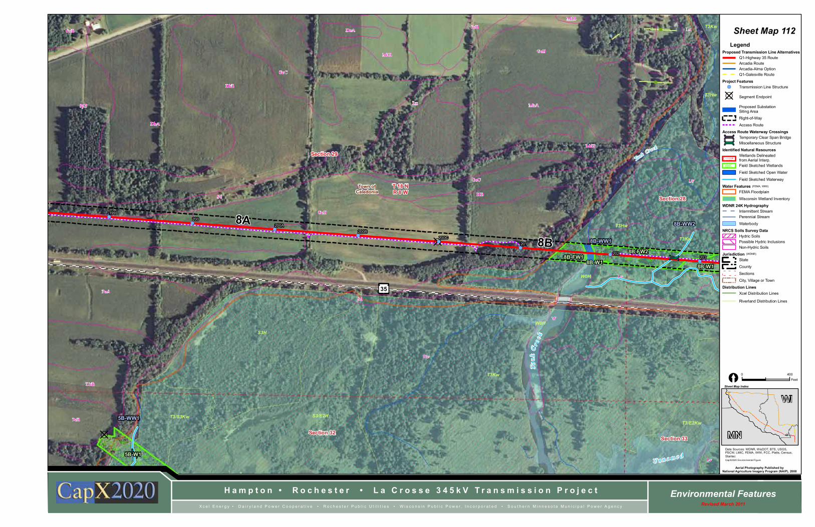
Sheet Map 112
WI
MN
LegendProposed Transmission Line Alternatives
Q1-Highway 35 RouteArcadia RouteArcadia-Alma OptionQ1-Galesville Route
Project Features!( Transmission Line Structure
?D Segment Endpoint
Proposed SubstationSiting Area
Right-of-Way
Access Route
Access Route Waterway Crossingsú Temporary Clear Span Bridgeú Miscellaneous Structure
Identified Natural ResourcesWetlands Delineatedfrom Aerial Interp.Field Sketched Wetlands
Field Sketched Open Water
Field Sketched Waterway
Water FeaturesFEMA Floodplain
Wisconsin Wetland Inventory
WDNR 24K HydrographyIntermittent StreamPerennial Stream
Waterbody
NRCS Soils Survey DataHydric SoilsPossible Hydric InclusionsNon-Hydric Soils
JurisdictionState
County
Sections
City, Village or Town
Distribution LinesXcel Distribution Lines
Riverland Distribution Lines
(FEMA, WWI)
(WDNR)

ú
úúúú
!(
!(
!(
!(
!(
!(
!(
Sh in gle C
reek
Tank Creek
GoB
Sa
MoA
WLv
Lv
We
Sd
MoA
We
LvW
656A
1658A
W
W
35
Section 34Section 33
Section 27Section 28
T 18 NR 8 W
TREMPEALEAU
LA CROSSE
U
n n a m e d
B l a c k R i v e r
S3/W0H
T3Kw
T3Kw
T3/E2Kw
W0H
T3Kw
T3/E2Kw
T3Hw
T3Hw
E2H
T3Kw
U
T3/E2Kw
T3Kw
Town ofHolland
Town ofCaledonia
8B
BC
204 205
206207
209
203
2088B-WW11
8B-WW58B-W1
8B-FW2
8B-W28B-FW3
8B-WW8
8B-WW98B-WW7
8B-WW4
8B-WW108B-WW6
8B-WW3
8B-WW2
H a m p t o n • R o c h e s t e r • L a C r o s s e 3 4 5 k V T r a n s m i s s i o n P r o j e c t Environmental FeaturesRevised March 2011X c e l E n e r g y • D a i r y l a n d P o w e r C o o p e r a t i v e • R o c h e s t e r P u b l i c U t i l i t i e s • W i s c o n s i n P u b l i c P o w e r , I n c o r p o r a t e d • S o u t h e r n M i n n e s o t a M u n i c i p a l P o w e r A g e n c y
Data Sources: WDNR, WisDOT, BTS, USGS,PSCW, LMIC, FEMA, WWI, FCC, Platts, Census,StantecCapX2020 Environmental Figure
Sheet Map Index
Aerial Photography Published byNational Agriculture Imagery Program (NAIP), 2008
0 400Feet[
Sheet Map 113
WI
MN
LegendProposed Transmission Line Alternatives
Q1-Highway 35 RouteArcadia RouteArcadia-Alma OptionQ1-Galesville Route
Project Features!( Transmission Line Structure
?D Segment Endpoint
Proposed SubstationSiting Area
Right-of-Way
Access Route
Access Route Waterway Crossingsú Temporary Clear Span Bridgeú Miscellaneous Structure
Identified Natural ResourcesWetlands Delineatedfrom Aerial Interp.Field Sketched Wetlands
Field Sketched Open Water
Field Sketched Waterway
Water FeaturesFEMA Floodplain
Wisconsin Wetland Inventory
WDNR 24K HydrographyIntermittent StreamPerennial Stream
Waterbody
NRCS Soils Survey DataHydric SoilsPossible Hydric InclusionsNon-Hydric Soils
JurisdictionState
County
Sections
City, Village or Town
Distribution LinesXcel Distribution Lines
Riverland Distribution Lines
(FEMA, WWI)
(WDNR)

?D
!(
!(
!(
!(
!(
!(
!(
Sa
We
Lv
W
2003A
511B
W
W
656A
1658A
413A
501A
511F
1658A
501A
501A
1658A
511C
511B
W
W
35
Section 34 Section 35
Section 26Section 27
T 18 NR 8 W
LA C
RO
SS
E
TRE
MP
EA
LE
AU
B l a c k R i v e r
N e w C h a n n e l
Bla
c k R
i ve r
Un
na
med
Go
ose
La
ke
T3/7Hw
E1Kw
T3Kw
T3Kw
S3/W0H
T3Kw
T3Kw
T3/7Hw
E2H
T3Kw
T3Kw
T3Kw
Town ofHolland
Town ofCaledonia
8C
8B
BD
BE
211212 213
214
216
215
210
8B-WW13
8B-WW11
8B-FW4
8B-FW5
8B-WW17
8B-WW14
8B-WW16 8B-WW18
8B-WW12
8B-WW15
H a m p t o n • R o c h e s t e r • L a C r o s s e 3 4 5 k V T r a n s m i s s i o n P r o j e c t Environmental FeaturesRevised March 2011X c e l E n e r g y • D a i r y l a n d P o w e r C o o p e r a t i v e • R o c h e s t e r P u b l i c U t i l i t i e s • W i s c o n s i n P u b l i c P o w e r , I n c o r p o r a t e d • S o u t h e r n M i n n e s o t a M u n i c i p a l P o w e r A g e n c y
Data Sources: WDNR, WisDOT, BTS, USGS,PSCW, LMIC, FEMA, WWI, FCC, Platts, Census,StantecCapX2020 Environmental Figure
Sheet Map Index
Aerial Photography Published byNational Agriculture Imagery Program (NAIP), 2008
0 400Feet[
Sheet Map 114
WI
MN
LegendProposed Transmission Line Alternatives
Q1-Highway 35 RouteArcadia RouteArcadia-Alma OptionQ1-Galesville Route
Project Features!( Transmission Line Structure
?D Segment Endpoint
Proposed SubstationSiting Area
Right-of-Way
Access Route
Access Route Waterway Crossingsú Temporary Clear Span Bridgeú Miscellaneous Structure
Identified Natural ResourcesWetlands Delineatedfrom Aerial Interp.Field Sketched Wetlands
Field Sketched Open Water
Field Sketched Waterway
Water FeaturesFEMA Floodplain
Wisconsin Wetland Inventory
WDNR 24K HydrographyIntermittent StreamPerennial Stream
Waterbody
NRCS Soils Survey DataHydric SoilsPossible Hydric InclusionsNon-Hydric Soils
JurisdictionState
County
Sections
City, Village or Town
Distribution LinesXcel Distribution Lines
Riverland Distribution Lines
(FEMA, WWI)
(WDNR)

?D!(!(
!(!( !(
!(
502B2
511F
501A
413A
511B
502B2
511B
502B2511B
502B2
511B
502B2
501A511C
413A
511B
511B
511B
511B
2030
511C
501A
502C2
501A
501A
Section 26 Section 25
Section 35
Section 36
T 18 NR 8 W
Town ofHolland
8C217218 219 220
221
216
H a m p t o n • R o c h e s t e r • L a C r o s s e 3 4 5 k V T r a n s m i s s i o n P r o j e c t Environmental FeaturesRevised March 2011X c e l E n e r g y • D a i r y l a n d P o w e r C o o p e r a t i v e • R o c h e s t e r P u b l i c U t i l i t i e s • W i s c o n s i n P u b l i c P o w e r , I n c o r p o r a t e d • S o u t h e r n M i n n e s o t a M u n i c i p a l P o w e r A g e n c y
Data Sources: WDNR, WisDOT, BTS, USGS,PSCW, LMIC, FEMA, WWI, FCC, Platts, Census,StantecCapX2020 Environmental Figure
Sheet Map Index
Aerial Photography Published byNational Agriculture Imagery Program (NAIP), 2008
0 400Feet[
Sheet Map 115
WI
MN
LegendProposed Transmission Line Alternatives
Q1-Highway 35 RouteArcadia RouteArcadia-Alma OptionQ1-Galesville Route
Project Features!( Transmission Line Structure
?D Segment Endpoint
Proposed SubstationSiting Area
Right-of-Way
Access Route
Access Route Waterway Crossingsú Temporary Clear Span Bridgeú Miscellaneous Structure
Identified Natural ResourcesWetlands Delineatedfrom Aerial Interp.Field Sketched Wetlands
Field Sketched Open Water
Field Sketched Waterway
Water FeaturesFEMA Floodplain
Wisconsin Wetland Inventory
WDNR 24K HydrographyIntermittent StreamPerennial Stream
Waterbody
NRCS Soils Survey DataHydric SoilsPossible Hydric InclusionsNon-Hydric Soils
JurisdictionState
County
Sections
City, Village or Town
Distribution LinesXcel Distribution Lines
Riverland Distribution Lines
(FEMA, WWI)
(WDNR)

!(
!(
!(!(!(
Hal
fway
Cre
ek
2013
502B2
609A
502B2
502B2
21A
502B2
502B2
511B
501A 501A
511F
608A
501A
511F
511C
511F
502B2
502C2
606A 501A
502B2
676A
502C2
502B2
502B2
2013
Section 18
Section 13
Section 7Section 12
T 17 NR 7 W
T 17 NR 8 W
E1x
E2K
Illegible
Village ofHolmen
Town ofOnalaska
18H
BI
EQ
770
592B
593
827
H a m p t o n • R o c h e s t e r • L a C r o s s e 3 4 5 k V T r a n s m i s s i o n P r o j e c t Environmental FeaturesRevised March 2011X c e l E n e r g y • D a i r y l a n d P o w e r C o o p e r a t i v e • R o c h e s t e r P u b l i c U t i l i t i e s • W i s c o n s i n P u b l i c P o w e r , I n c o r p o r a t e d • S o u t h e r n M i n n e s o t a M u n i c i p a l P o w e r A g e n c y
Data Sources: WDNR, WisDOT, BTS, USGS,PSCW, LMIC, FEMA, WWI, FCC, Platts, Census,StantecCapX2020 Environmental Figure
Sheet Map Index
Aerial Photography Published byNational Agriculture Imagery Program (NAIP), 2008
0 400Feet[
Sheet Map 116
WI
MN
LegendProposed Transmission Line Alternatives
Q1-Highway 35 RouteArcadia RouteArcadia-Alma OptionQ1-Galesville Route
Project Features!( Transmission Line Structure
?D Segment Endpoint
Proposed SubstationSiting Area
Right-of-Way
Access Route
Access Route Waterway Crossingsú Temporary Clear Span Bridgeú Miscellaneous Structure
Identified Natural ResourcesWetlands Delineatedfrom Aerial Interp.Field Sketched Wetlands
Field Sketched Open Water
Field Sketched Waterway
Water FeaturesFEMA Floodplain
Wisconsin Wetland Inventory
WDNR 24K HydrographyIntermittent StreamPerennial Stream
Waterbody
NRCS Soils Survey DataHydric SoilsPossible Hydric InclusionsNon-Hydric Soils
JurisdictionState
County
Sections
City, Village or Town
Distribution LinesXcel Distribution Lines
Riverland Distribution Lines
(FEMA, WWI)
(WDNR)


![[HnF] High School DxD Volume 02](https://static.fdocuments.in/doc/165x107/577cd2f21a28ab9e7896608e/hnf-high-school-dxd-volume-02.jpg)