
Teck-Hua Ho Copyright © 2009 Teck-Hua Ho SMART Revenue Model Design Teck Ho UC, Berkeley.
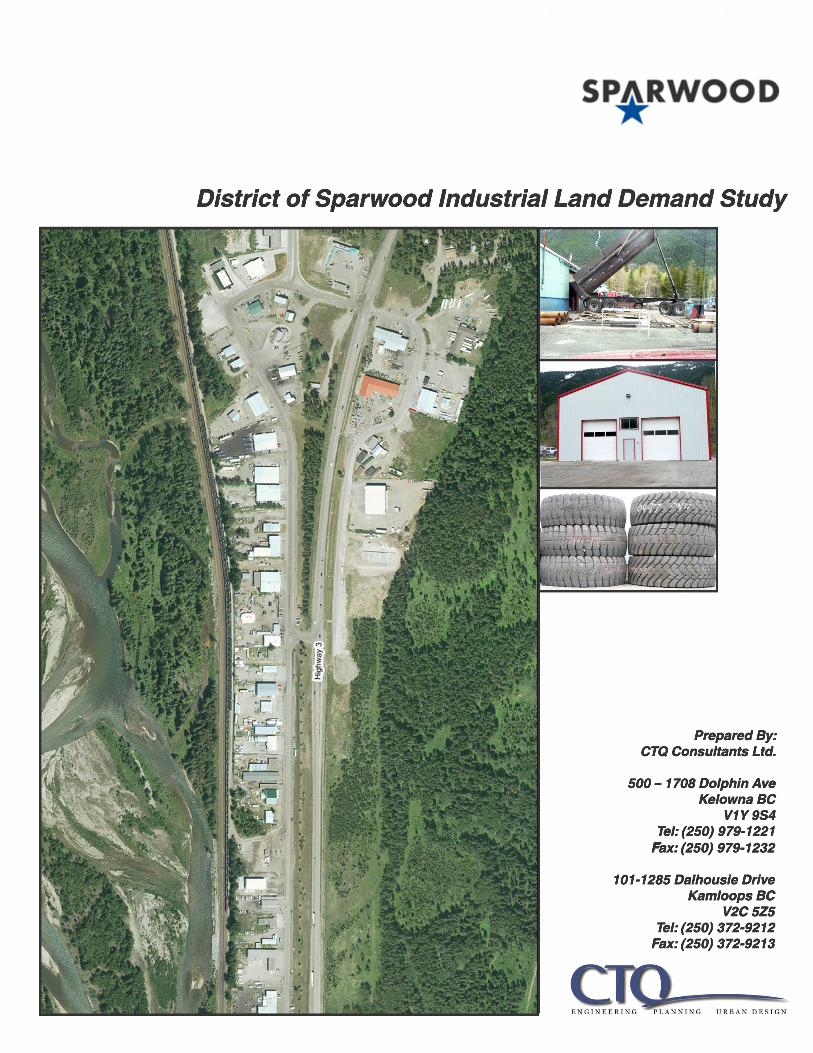
District of Sparwood Industrial Land Demand Study
Prepared By:CTQ Consultants Ltd.
500 – 1708 Dolphin AveKelowna BCV1Y 9S4
Tel: (250) 979-1221FFax: (250) 979-1232
101-1285 Dalhousie DriveKamloops BC
V2C 5Z5Tel: (250) 372-9212Fax: (250) 372-9213

Page 1
District of Sparwood Industrial Land Demand Study
Table of Contents
Section 1.0 Introduction .......................................................................................................................... 2 Section 2.0 Current Situation in Sparwood ............................................................................................. 4 Section 3.0 Demand Defined ................................................................................................................... 6 Section 4.0 Competition (East Kootenays) .............................................................................................. 8 Section 5.0 Criteria for End Users ............................................................................................................ 10 Section 6.0 Zoning and Design Guideline Issues ...................................................................................... 11 Section 7.0 Conclusions and Recommendations to District of Sparwood............................................... 12
Appendix 1 Focus Group Attendees Appendix 2 BC Assessment Information and Listings/Sales Information for Select Communities in
East Kootenays Appendix 3 Figures Showing Lot Sizes, Building Sizes, and Corresponding use in Select Communities

Page 2
1.0 Introduction
Overview study to help position industrial lands at Sparwood Drive/Highway 3 South
The District of Sparwood is a community of almost 3700 people located in Southeastern BC, within the
Regional District of East Kootenay. Its economic base has been primarily mining related since it was
incorporated in 1966. The coal mining sector specifically has helped Sparwood and region recently
become a successful economy, attracting jobs, investment, suppliers and families to the area. Although
reliance on the same sector had previously caused Sparwood to decline, there is now a significant sense
of optimism for regenerating the local economy. Much of this optimism comes from the fact that Teck
Resources Ltd has invested considerably in their five local area mines in the Elk Valley: Fording River;
Elkview; Greenhills; Coal Mountain; and Line Creek. Production for Teck’s mines was reported at 22.8
million tons of coal in 2011 and has a projection of approximately 25 tons for 2012. (This is assumed for
all Teck coal mines. Details regarding production for each of the Elk Valley mines is available.) Based on
production rates from 2009, Greenhills mine alone has proven and probable reserves to support
production for another 25 years; Fording River at 41 years; Coal River at 9 years; and Line Creek at 10
years. Teck not only mines the coal but processes its coal in the area before shipping by CP Rail to west
coast ports. This activity is forecast by Teck to continue to grow relative to world demand especially in
the steelmaking (metallurgical) coal market. The growth is in turn expected to continue to translate into
“outsourcing” of many services and suppliers that Teck requires for its operations in the Elk Valley and
Sparwood area in particular. Teck’s Elk Valley operations headquarters are also strategically located in
Sparwood.
As a result of the current and pending industrial growth in the area, the District of Sparwood has
launched a proactive effort to provide sufficient industrial land to accommodate the growing supplier
base. All accounts suggest that there is existing demand for industrial and commercial lots to
accommodate development for a vast cross section of services and suppliers; be they maintenance,
fabrication, warehousing, equipment, manufacturing or other services. Sparwood’s land base is
physically constrained making its industrial land development options much more limited than many
other communities in the interior of BC. The District’s proactive strategy is therefore to identify, service,
and appropriately zone more industrial land in Sparwood.
This brief industrial land demand study supplements an investigation to develop some land along
Highway 3 at the south end of the existing Sparwood Drive Industrial area. It is simply an overview study
to help better position industrial development in Sparwood generally, but more specifically at the
Sparwood Drive/Highway 3 South area. (NOTE: It is acknowledged by the District officials that a more
comprehensive review of land use and potential of land areas to accommodate specific uses, will be
undertaken at the time of updating their Official Community Plan)

Page 3
Focus Group
The key information for this exercise was drawn from a focus group meeting of local and regional
informants held in Sparwood in mid May, 2012. The participants were an excellent representative cross
section of professionals and businesses from various fields: real estate, legal, appraisal, major industrial,
banking/lending, local developer/builders and the municipality.
Main items of discussion focused on the following:
Current Situation with Sparwood and the Industrial Land
Expected Demand for Industrial and Commercial Use
Types of Uses/End Users and their criteria
Lots sizes, phasing and assembly to help the District with market positioning
Zoning and Design Guidelines
Building types/Issues
Other Goals and Objectives to bring to the attention of the Municipality
(A list of attendees is attached as Appendix 1)
Research
Although documented information on industrial land/market supply and demand for the Sparwood area
specifically is very limited, the consultants sourced information from realtors and appraisals. For
example, little is documented about the specifics of what is available in terms of services, zoning, lot
sizes, ownership, uses and occupancy. An attempt was also made at discerning (industrial land)
competition from other communities in the East Kootenays, mainly to help establish a benchmark for
types of industrial land that could be supported for Sparwood.
Other
The consultant recently completed an industrial land market overview for a project in the West
Kootenays which was referenced for this study. Although the situation in the West Kootenays is not
directly applicable to Sparwood, there are industrial land development trends that we can draw from to
help position Sparwood’s supply of industrial land.
Does not address financial/cost of real estate or commercial land
This overview was not intended to help establish pricing for industrial lot sales, however, assessment
data, sales listings and some sold prices were reviewed and have been appended to help depict trends
throughout a number of East Kootenay communities. Again, there is limited information and
transactions for Sparwood.

Page 4
An issue encountered with any industrial land study is the fact that there is often a fine line
differentiating between defining certain commercial uses and industrial uses. Although we understand
that industrial land needs are translating into absorption of some of the formerly zoned commercial land
in Sparwood, this overview did not examine commercial land supply and demand.
2.0 Current Situation in Sparwood
The following provides an overview of the industrial land situation relative to Sparwood today. It
establishes the appreciation that there is a growing demand for a relatively limited supply of market
ready industrial land. Again, much of this information was provided by the focus group participants,
other local informants and municipal officials.
Teck growth implications
Bigger companies are now coming to Sparwood wanting to establish warehouses, banks, and
even small manufacturing, largely attributed to the investment in mining and processing by Teck
Resources Ltd.
More suppliers that currently service Teck could locate in the area if land was available for
industrial development
More services for both Teck and the local population needs will likely be required
Preliminary feedback from Teck suggests enquiries for the following:
o Automotive service – repair and dealerships
o Scaffolding service
o Heavy Duty repair service
o Steel Fabrication service
o Heavy Duty Crane service
(Note: Teck was not in a position to release purchasing and procurement information of their various
supplier categories)
- Strata units have become available (e.g. Star Business Centre), providing small office, retail and
shop space to address demand from smaller users (e.g. 1,000-2,000 sq ft bays)
- Some operators need/want to lease as opposed to make a major investment in building (shorter
term business horizon or fitting into their business plan)
- More branch offices/locations want to locate in Sparwood for the profile (Satellite offices)
- P and H Minepro Services (Joy Global) now has three locations on Douglas Fir Road, but has
announced construction of a new building to consolidate their operations; space will therefore
become available when the old premises are vacated (forecast for 1 to 2 years)

Page 5
Industrial land areas (limited land base)
The following three main areas of industrial uses are located in Sparwood:
1. Elk Valley Industrial (near Michel Creek off Highway 43)
2. Douglas Fir Road Area (Towards south end of town, West of Highway 3)
3. Sparwood Drive Industrial Area (Towards south end of town, East of Highway 3)
Each of these areas is zoned for Light Industrial (M1) that would satisfy much of the type of industrial
demand that is forecast for Sparwood if sufficient space was available. The Official Community Plan
suggests that there is a small amount of prime developable land in the vicinity of the Elk Valley Industrial
Park and in the Sparwood Drive Industrial area. Each of these two areas is complemented by some
marginally developable adjacent land. The Elk Valley Industrial area would require some redevelopment
of an older residential neighbourhood. The Sparwood Drive Industrial area (the subject of this study) is
constrained to the east by steeper slopes making the expansion area mainly to the south along Highway
3. According to the OCP, this allows for approximately 6 acres of prime developable area along the
highway; additional sloped land and benches above and to the east, and further south, would need to
be confirmed for geotechnical stability and feasibility of road access. This area is also not currently
serviced.
The Douglas Fir Road area is largely built out and is not-serviced with municipal sewer. The lots in this
older industrial precinct are largely .5 acre (.2 Ha) which are reportedly too small to meet the needs of
many current or prospective industrial tenants.
Documented information about the supply of lots (serviced and unserviced) is not available for
Sparwood, however feedback from realtors, District officials and a review of real estate listings confirm
that very little is available to suit industrial use. Lots are available further up Highway 43 at Elkford, but
would not serve the same purpose as those closer to or within Sparwood.
Industrial uses taking up commercial-zoned lands
There is concern that due to the expressed need to find industrial lots in Sparwood, some commercial
(e.g. C-2 Highway Commercial ) is being taken up or may be rezoned for industrial uses, limiting the
supply of strategically located commercial lands for the future. Caution was offered that the high
exposure lands along the highway would be in greatest demand. Nevertheless, some informants
suggested that demand for “big box” retail and other highway commercial may be limited in Sparwood
due to the predominance of local residents shopping in Alberta. Opportunities for highway commercial
ventures such as truck stops (travel centres), hotels/motels and restaurants, and auto service stations to
name a few, should be protected for the future.
In summary, it is clearly apparent that demand is exceeding supply of serviced industrial lots, and that if
Teck Resources coal mining activity continues as projected; there could be incremental need for such
real estate at least for the next 5 to 10 years. Also, it appears apparent that the supply of good quality
land to accommodate light industrial activity is challenged in Sparwood. The Sparwood Drive Industrial

Page 6
area expansion may serve to satisfy some of the demand in the short term; however, the longer term
opportunities for industrial land will require the District to look beyond these lands and potentially even
beyond the current municipal boundary.
3.0 Demand Defined
This section helps better define the demand that has been suggested above, and that can help inform
future industrial land areas to be created by Sparwood. We have profiled the demand according to the
following:
- By Zoning type
- By General Criteria
- By Supplier types (Mining Industry)
- Reference to other location (West Kootenays)
Zoning Type (light industrial/service commercial, etc)
The following are typical permitted land uses in a light industrial or service commercial zone. This listing
does not preclude changes to the Sparwood Zoning Bylaw M1 Zone, or for new zones to be created to
accommodate expected demand. These typical uses do however provide an indication of the ultimate
end users, their scale and activity needs associated with their day to day operations.
Light Industrial Permitted Uses - Example
Warehousing, distribution, light manufacturing/fabrication, equipment service and repair, automotive
sales/service and car wash, machinery sales/service, building materials, hardware, garden supplies,
building contractors (outdoor storage must be screened), manufactured home sales, veterinary clinics
(small animals only), plumbing and other trades shops and offices.
Care must be taken regarding compatibility between uses. This zoning type restricts the amount of
retail, and heavy manufacturing that may cause compatibility problems. An issue that is regularly
encountered with this type of zone is on-site storage/outdoor industrial activity that is typically either
limited, screened or covered, or otherwise not permitted and directed to another zone.
Criteria
The above-noted types of uses raise the need for the following site location criteria, many of which were
presented by the focus group participants:
Flexibility if possible – permitting the variety of end users and their combined needs such as large
buildings, storage, parking, office space and even some retail.
Strata buildings to allow smaller users in independent bays – many of the trades or even independent
suppliers of services, maintenance, and parts may require smaller industrial spaces.

Page 7
2± acres or larger lots – Based on examples from other jurisdictions and recent development trends in
Sparwood, accommodation of the above noted types will require some larger lots, allowing for 10,000
to 20,000 square foot buildings, storage space, parking, and sufficient setback requirements.
Consolidation of smaller lots (1 to 1.5 acres) would allow for even larger lots (upwards of 3 acres).
Yard space for storage – The types of uses that involve light manufacturing, fabrication, cranes and even
certain service and repair of equipment and machinery will entail some storage requirements. Unless
retail activity is involved, appropriate screening or covered storage and siting conditions should be
required to address both unsightliness from the highway and compatibility between uses.
Parking lots – Sufficient parking will be required for employees, visitors and associated truck haul,
delivery and movements. The Zoning Bylaw should ensure that parking requirements are not onerous
but avoid the issue of spilling out onto adjacent roads. Provision of snow storage areas should also be a
requirement.
Design guidelines to treat aesthetics along highway – The type of light industrial uses noted above have
the potential of becoming unsightly premises especially as they may relate to the gateway into
Sparwood. Strict design guidelines that can address the form and character of buildings and landscape
on each lot can achieve significant mitigation of visual impact associated with industrial activity. (The
District would likely include boulevard landscaping to complement on-site landscaping requirements.)
Supplier Types
Although a listing of suppliers to Teck Resources was not available, one can garner significant
understanding of the types of suppliers generally serving the mining industry by reviewing the list of
suppliers associated with the Mining Suppliers Association of BC
(http://miningsuppliersbc.ca/suppliers). It is a very extensive list of suppliers, contractors and
consultants that are actively involved in the mining industry and especially coal mining in the East
Kootenays. It is known that many of these businesses are already located in Sparwood with their main
regional offices, branch outlets or even headquarters, such as Joy Global.
Typical supplier services may include the following:
- Drilling equipment and consumables/repair and parts
- Engine service and distribution
- Pumps, motors, valves, plating and machining
- Mining tires sales and service, including retreading
- Service of shovels, draglines, crushing, and conveying systems
- Loaders and heavy machinery sales and services
- Chemicals sales and application
- Tanks and tubing sales, service and repair
- Electrical switchgear and controls
- Steel and metal fabrication

Page 8
Information from West Kootenays
A recent study in the West Kootenays provided an industrial land overview for an industrial park
development near Trail, BC. Some insight can be obtained from that study:
- Demand for Industrial lot sizes throughout the region were 1-5 acres, with consolidation often
required to satisfy larger users
- Some clustering of uses/similar activities is achieving many objectives
- Significant demand in storage, warehouse and distribution
- Municipal sewer service (outskirts of towns) may not be required for many uses
- Demand could be for lots up to 10 acres in size for industry requiring lay down yards and
outdoor storage
- Presence of a main anchor will attract other associated users
- When lot prices are low, user may purchase more land than required allowing for inefficiencies
of land use in the short term.
4.0 Competition (East Kootenays)
The following is a brief overview of the industrial land situation in some of the main communities that
may be considered to be in competition with Sparwood. It is understood that more distant communities
such as Cranbrook may have less influence on the Sparwood situation unless the site location
determinants cause the end users to consider the (East Kootenay) region as their market. This may
include regional headquarters/branch offices or outlets, larger manufacturers or fabricators or larger
warehouses/distributors that are relying on a larger market than simply directed at Teck’s day-to-day
needs, or the smaller Elk Valley (Sparwood and Elkford) market.
Cranbrook
All accounts suggest that there is still a significant, or excess, supply of industrial zoned and serviced
land in Cranbrook. This inventory dates back to the mid 1970s when the economic boom caused the City
to develop their own land. Information gained from Assessment files indicate that between 2005 to
2012, most sales occurred in a short period of 2005-2007, with minor resales between 2008 and 2010.
Of the 32 lots that sold since 2005, 18 (56%) remain unimproved. There have been minimal sales over
the last year, and there is currently construction occurring on one lot only. Furthermore, assessment
information shows that lands have been sold and resold several times in some cases, and with attendant
changing values, in many instances dropping in price or value. (See Appendix 2 under separate cover.)
Records from both listings, sales and assessments indicate that most transactions involve lot sizes in the
one to two acre range. The older industrial area along Cobham Avenue West, however, has larger lot
sizes closer to 5 acres for the M1 zoned lands and 3.5 acres for the M2 zoned lands. It is recognized that
the larger lots often have underutilized land area on their sites, regardless of activity. (See Appendix 3)

Page 9
It should be noted that the City of Cranbrook has also initiated investigation of developing more
industrial land near the Cranbrook Airport, largely on First Nations land. This initiative has been in the
works since 2008 and negotiations between the City and First Nations is still ongoing. Much of this effort
is directed at aviation related manufacturing and services but if the land is well priced, it will create even
more general industrial supply in the Cranbrook/East Kootenay region.
Fernie
The City of Fernie, which is only approximately 20 miles away from Sparwood, reportedly has a very
limited supply of light industrial land. BC Assessment information currently shows that there are four
main parcels of vacant industrial land in Fernie, all within the Ridgemont Industrial Subdivision. They are
6.8, 6.1, 1.6 and 1.8 acre lots; otherwise all other properties are commercially zoned and much more
limiting for industrial or service commercial type uses.
Elkford
The District of Elkford is only approximately 20 miles, or less than one half hour, from Sparwood along
Highway 43. Records show that there are only three industrial lots (zoned I-1) available in the District’s
Industrial Park located at the south end of town. Commercially zoned ((C-2) properties are also available
but more limiting for industrial type uses. District of Elkford listings currently (March, 2012) show eight
listings in this category. The industrial lots are all approximately one half acre while the commercial lots
are closer to one quarter acre or smaller.
This brief review serves to show that there is minimal competition to meet the current demand in
Sparwood. Although rural industrial areas were not investigated, we could surmise that lands that could
accommodate large expansive development outside of the municipalities would be unserviced and likely
require further development approvals. This would include any crown-owned lands. Although the
industrial land inventory in Cranbrook is significant, the distance alone (75 miles from Sparwood), will
preclude many of the suppliers interested in servicing Teck’s immediate needs. Nevertheless, certain out
of Province or larger enterprises seeking a foothold in the East Kootenay region may consider Cranbrook
as a suitable site location, especially if appropriate industrial land is not available in or closer to
Sparwood. These investment decisions will also consider price of land as a site location factor. (Sales
data does indicate that land is less expensive in Fernie and Cranbrook than Sparwood.)

Page 10
5.0 Criteria for End Users
The following were the key criteria raised by the focus group participants, all of which should be
considered for the future accommodation of industrial uses in Sparwood.
Lot sizes
New industrial lots to be created should respect a diversity of needs, but there was general consensus
that there should be a proportion of the new lots to be developed that would be larger than the older
half acre (Douglas Fir Road) and even larger than the newer 1 to 1.5 acre (Sparwood Drive ) lots. These
larger lots could potentially accommodate buildings larger than 10,000 sq ft, parking and truck turn
around areas, and outdoor storage/display or some outdoor industrial activity, including space for
cranes. The suggestion was for 2 and 3 acre lots to be added to the Sparwood inventory. (This should
not preclude consolidation of smaller 1 and 1.5 acre lots to meet the demand for the larger lot sizes.)
A review of examples of newer industrial parks in other parts of BC (Kelowna included) have shown that
1 to 2 acres are becoming more of the norm in lot sizes. However, this size allows for a mix of business
industrial and light industrial where standards in design may be higher than the older conventional light
industrial parks. Two to three acres or larger are supporting light industrial uses where more outdoor
activity, storage and parking may be required. Care must be taken in creating inefficiencies of land
utilization when planning larger lots.
There may be some circumstances or opportunities that will dictate some larger industrial or highway
commercial lots in the vicinity of the Sparwood Drive South area. This could imply up to 5-6 acre lots. For
example, some truck stop/travel centre developments can accommodate truck repair, gas bar, motel,
restaurants, overnight truck parking and other commercial convenience. (NOTE: Many truck stop/travel
centre zoning provisions will call for a minimum of 5 to 10 acres depending on the route numbered
highway within which the community is located.) Once again, care must be taken not to create
inefficiencies of land utilization, and not to use up land that may be suited for a higher and better use.
Mixed uses
There was a feeling that there will be a growing interest in permitting a mixture of uses in one area. This
would imply some retail along with office, service/repair and manufacturing or fabrication in the same
industrial area. This may entail a mixture of two or three zones to avoid incompatibility or appropriate
blending of uses through setback requirements, design guidelines and buffers.
Outdoor Storage and Yards
It appears that much of the demand that will result from Teck’s ongoing service and supply
requirements will be related to outdoor storage needs. Activities such as steel fabrication, heavy duty
equipment repair and crane service will require both indoor and outdoor yard space. Outdoor storage
yards become critical components of unsightly premises or incompatibility between certain uses.

Page 11
Zoning, design guidelines and siting requirements, especially along the highway, must be addressed so
that industrial development does not compromise the other planning and design goals of the District.
Parking lots
Depending on the uses permitted on the lot, parking (paved or unpaved) can consume the second
highest proportion of the space in an industrial lot after the building itself. There was certainly
consensus that the lots created should accommodate sufficient space for parking of employees/tenants
and truck circulation/turning radius, along with other potential outdoor activity.
Building sizes
The focus group participants suggested that building size requirements for the new industrial area could
range from 1600 to 10,000 square feet. A quick review of the existing buildings in both the Sparwood
Drive and Douglas Fir Industrial areas indicates that there are several buildings on the 1 acre to 2.5 acre
lots that are at least 10,000 square feet, and one up to 15,000 square feet (on a 2.3 acre lot). This
translates into approximately 15 to 25 percent of the lot being consumed by the principal building
space. If the uses are largely warehouse or distribution oriented (all activity contained indoors), a
building could conceivably occupy closer to 40 percent of the lot. This indicates that depending on uses
being proposed the smaller lot sizes of 1 to 1.5 acres are still very relevant for Sparwood. However, as
the building sizes and outdoor storage and activity requirements expand, the attendant lot sizes should
be closer to the 2.5 and 3 acres (or larger) as noted earlier. (See Appendix 3)
With respect to the smaller building space requirements (say closer to 1000-2000 square feet), it would
be appropriate to consider smaller strata lots or likely strata units in a building. Furthermore, some of
these uses may be more appropriately located in commercially zoned areas. Typical uses may include
professional office, technical, labs, retail/sales, and even small trades services that are not assembling,
constructing or fabricating on site.
6.0 Zoning and Design Guideline Issues
The focus group participants were very cognizant of the need to address certain zoning and design
issues that would enhance aesthetic appeal, safety, compatibility and quality development of the site.
Obviously, the geography of the land will in part dictate the details, but some of the main issues are as
follows:
Site coverage – leaving space beyond the building and parking area
Means to treat covered storage areas with design guidelines
Rear and side yard setbacks to address compatibility with adjacent properties
Screening and buffering of outdoor manufacturing or storage
On-site snow storage
Building design along the highway (e.g. protecting the high exposure value lands)
Page 12
Appropriately scaled and designed commercial signs
Roadway standards (curb, gutter, lighting, etc)
These issues imply that current zoning and design guidelines may need to be changed or upgraded to
reflect the needs of developing in this area. As well, it will be important to respect the desire of the
community and Council to build a livable and aesthetically pleasing neighbourhood.
7.0 Conclusions and Recommendations to District of Sparwood
This overview study has concluded the following. Recommendations are provided for the District’s
consideration in future work towards positioning their industrial land supply.
1. Demand and Lot sizes
Although historic absorption rates may not be an indicator, it appears that as the Sparwood and
area population grows, and as the production from Teck mines continues at least 10 years into
the future, there should be continued need for industrial lands. If we estimate conservatively at
2 to 3 acres per annum, we can assume a need of 20 to 30 acres over approximately 10 years,
with likely a higher take up in the first few years, since there is a reported current pent up
demand. A mid range forecast could assume 3 to 6 acres per annum accounting for 30 to 60
acres over 10 years. A high range forecast would be very speculative at best but we could
assume up to 10 acres per annum, especially if some larger enterprises, mixed commercial and
light industrial or something like a travel centre are mixed in; this could see upwards of 80 to
100 acres in approximately 10-15 years. Obviously, if suitable lands are not available in
Sparwood proper, demand would need to spill over to surrounding communities or rural area, if
servicing was made available there.
With respect to lot sizes, it is recommended that lots be planned and designed for 1 and 2 acres;
2.5 and 3 acres and some even larger than 3 acres. If the District feels confident that it can meet
the mid range forecast (30-60 acres) over 10 years, then the proportion of the 2.5 to 3 acre lots
should be greater than the proportion of smaller lots (for example, 60 to 70%); otherwise the
initial lot sizes should be kept smaller (1 and 2 acres) which will allow for greater land
efficiencies and potentially reflect higher price points/profits per lot. This implies that
consolidation of two or more lots can still satisfy some of the demand for the larger users.
With respect to phasing, if we assume that 3 to 6 acres per annum will be the chosen scenario,
then at least twice that amount should become part of the first phase to establish some “market
readiness”, closer to the 10 to 15 acres range. Obviously, Teck’s investment and continued mine
production in the area as well as real estate enquiries should be monitored year after year to
confirm need for future phases.

Page 13
2. Highway Fronting Development
Although Sparwood is restricted in terms of where suitable land can be found to accommodate light
industrial development, it will be important to respect the Highway 3 entrance aesthetic appeal. The
focus group participants all recognized the importance of the gateway, and the continued expansion
southwards beyond Sparwood Drive with more industrial development has the potential of
compromising that gateway or entry into the community.
The highway fronting development on the east side can be addressed through changes to industrial
zoning provisions, directing more commercial or mixed use along the highway and/or enhanced form
and character design guidelines that would treat both building and landscaping.
3. Design Guidelines
Further to the above noted conclusion, it is recommended that the Industrial Area DPA guidelines be
enhanced to address the entire Sparwood Drive Industrial area, including the portion along the highway
and into the upper benches. Particular design elements to be considered would be building colors,
material choices, height, retaining walls, landscape, screening/fencing, commercial signs, lighting,
sidewalks and any other features to ensure compatibility between uses on the upper bench and lower
bench locations.
4. Zoning Changes
Zoning Bylaw changes may need to be made to address the particular end users expected to locate in
this area. This may entail amendments to the existing MI zone or the creation of a new zone to reflect a
focus on a cluster of cleaner business park type uses. A review of the C zones may also be in order to
ensure Sparwood can accommodate various types of commercial uses that may not fit into the M zones.
5. Comprehensive Plan (OCP Update)
The focus group participants and senior staff have all acknowledged that the growth expected in
Sparwood warrants a comprehensive review of both land uses and the lands that can best
accommodate various uses in the future. This can be done in the form of special studies or as part of an
overall Official Community Plan Update, wherein the industrial and commercial land situation can be
assessed in more detail. Council, community stakeholders such as Teck and various other businesses,
and the public should all have an opportunity to help set a vision and policy direction for this important
land use that has long term employment, economic development, social and environmental implications
for the community.
6. Communication with Teck Resources Ltd
It will be prudent for the District to maintain open communication with Teck Resources especially
regarding purchasing and procurement needs for the company’s operations in the Elk Valley. Any insight
gained from this information can better help position the District’s development and marketing of
industrial land, and achieve efficiencies in the limited industrial land base. The District does not need

Page 14
names of suppliers, but service and supply categories and their potential downstream needs will benefit
the District’s long term land development strategy. The District must also be prepared to provide Teck
with their needs and policy direction so that Teck officials can communicate effectively with their
outside contacts that express interest in Sparwood as an business site location.
It is extremely important to note that the demand for land, and in fact, the reason this analysis of
industrial land supply has been commissioned, is tied to the current Teck Resources policy of
outsourcing much of their supply and maintenance operations. If the Teck Resources policy changes in
the future, back to an internally-sourced model, it is entirely possible that the demand for land will drop
overnight. It follows that maintaining communications with Teck Resources and fostering a cooperative
attitude with that company will be important to getting the ‘heads-up’ from them if policy changes are
expected. As well, it may be advisable to request some form of commitment from Teck Resources that
they will maintain their outsourcing policy long enough to ensure that sales of serviced land are not
jeopardized. The District should not invest more than they can reasonably expect to be returned.
7. Marketing and Assessment of End Users
If the District is to continue as the main developer of industrial land in Sparwood, they will also need to
be responsible for effective market research and assessment of the needs of the potential end users.
Developing an up to date knowledge base of all matters relating to the diversity of the market will help
position their industrial land supply, obtain maximum profits and play an important role in economic
development for Sparwood and area.
8. Strata Developments
It is assumed that many of the future end users that may want to locate in Sparwood and area will not
require their own land or large buildings. The District should encourage strata buildings or strata lot
development where smaller or short term operations may want to locate. The success of buildings such
as the Star Business Centre should be monitored. Also, as some large buildings are vacated, there may
be opportunity for some entrepreneurs to transform them into smaller spaces for rental or strata units.
Strata development will also assist in using the limited land base in a more efficient manner.
9. Redevelopment Analysis
This preliminary overview has shown that there is some underutilized or inefficient use of lands that
could be eventually redeveloped for industrial use. According to the Planning Department s, these lands
have been formerly targeted for other uses, contain older neighbourhoods or have some land
constraints which could be mitigated to allow for a higher and better use. A redevelopment analysis
could be conducted as part of the OCP Update, or as a separate exercise that investigates specific lands
or properties and neighbourhoods, the results of which could then be fed into the OCP Update. The
benefits of such an analysis could eventually help add to the initial industrial land supply provided in the
Sparwood Drive Industrial area.

Page 15
10. Commercial Development Opportunities and Comparison
This preliminary overview has found that industrial land needs are competing with commercial land
needs and supply. Care must be taken that certain highway, neigbourhood, downtown or more general
commercial opportunities are not compromised for the future. Once again, a comprehensive review or
market analysis may be useful to ensure that the District’s commercial needs can be met for many years
of future growth. Care should also be taken to avoid big box retail locating on the outskirts of town
when there are some strategic opportunities for commercial development within the community.
11. Assessment of Other land
The District of Sparwood should be open to any opportunity to provide additional land for industrial use.
These opportunities could arise in several ways, whether by expanding District boundaries, acquiring
and assembling parcels, applying for removal of minor and low quality lands from the ALR, or
redeveloping contaminated/brownfield sites. In addition, swaps with business or other private property
owners as well as latent land should be considered where feasible.
Page 16
Appendix 1
Focus Group Attendees


Page 17
Appendix 2
BC Assessment Information and Listings/Sales Information for
Select Communities in East Kootenays

Tax Report - 572 INDUSTRIAL RoadRecord Updated - 07/02/2012
Jurisdiction 205-CRANBROOK - CITY OF Roll Number 05961025 Property ID 028-756-703Property Addr 572 INDUSTRIAL RDMunicipality CK-CITY OF CRANBROOK Board Code KNeighborhood 015-INDUSTRIAL PK W OF TRACKSArea K10-CranbrookSub Area K13-Northwest Cranbrook More PID'sGross Taxes Water Conn
Owner Name & Mailing Address InformationOwner(s) 1 Name & Address Owner(s) 2 Name & Address
104 8TH AVE SCRANBROOK BC
Legal Information
Plan # Lot Block Dist Lot Land Dist Section Township Range MeridianEPP15086 1 29 26
Legal Description PL EPP15086 LT 1 DL 29 LD 26
Land & Building InformationWidth Depth Lot Size 0.558 ACRESLand Use Actual Use VACANTBCA Description Zoning
BCAA Data Updated - 07/02/12
Total Value Information
Actual Totals Municipal Taxable Totals School Taxable TotalsLand Gross Land Gross LandImprovement Gross Improve Gross Improve
Exempt Land Exempt LandExempt Improve Exempt Improve
Actual Total Municipal Total $0 School Total $0
Sale History Information
Date Price Document # Type of Sales Transaction03/29/2012 $77,500 CA2458981 VACANT SINGLE PROP CASH TRANSA01/26/2012 CA2364049 REJECT NOT SUITED SALE ANALSIS
Tax Detail View The enclosed information while deemed to be correct is not guaranteed. 07/06/12 10:25 AM

Tax Report - 325 INDUSTRIAL RoadRecord Updated - 07/02/2012
Jurisdiction 205-CRANBROOK - CITY OF Roll Number 06618190 Property ID 026-761-459Property Addr 325 INDUSTRIAL RDMunicipality CK-CITY OF CRANBROOK Board Code KNeighborhood 015-INDUSTRIAL PK W OF TRACKSArea K10-CranbrookSub Area K13-Northwest Cranbrook More PID'sGross Taxes Water Conn
Owner Name & Mailing Address InformationOwner(s) 1 Name & Address Owner(s) 2 Name & Address** NOT AVAILABLE **
1304 22ND ST SCRANBROOK BC
V1C 0A6
Legal Information
Plan # Lot Block Dist Lot Land Dist Section Township Range MeridianNEP81551 7 28 26
Legal Description PL NEP81551 LT 7 DL 28 LD 26
Land & Building InformationWidth Depth Lot Size 1.5 ACRESLand Use Actual Use INDUSTRIAL VACANTBCA Description Zoning
BCAA Data Updated - 05/15/12
Total Value Information
Actual Totals Municipal Taxable Totals School Taxable TotalsLand $160,000 Gross Land $160,000 Gross Land $160,000Improvement Gross Improve Gross Improve
Exempt Land Exempt LandExempt Improve Exempt Improve
Actual Total $160,000 Municipal Total $160,000 School Total $160,000
Sale History Information
Date Price Document # Type of Sales Transaction11/14/2011 $120,000 CA2269484 VACANT SINGLE PROP CASH TRANSA08/29/2007 $91,000 CA551927 VACANT SINGLE PROP CASH TRANSA07/31/2006 LA105711 REJECT NOT SUITED SALE ANALSIS
Tax Detail View The enclosed information while deemed to be correct is not guaranteed. 07/06/12 10:25 AM

Tax Report - 1624 INDUSTRIAL Road
Jurisdiction 205-CRANBROOK - CITY OF Roll Number 06618140 Property ID 026-761-408Property Addr 1624 INDUSTRIAL RDMunicipality CK-CITY OF CRANBROOK Board Code KNeighborhood 015-INDUSTRIAL PK W OF TRACKSArea K10-CranbrookSub Area K13-Northwest Cranbrook More PID'sGross Taxes Water Conn
Owner Name & Mailing Address InformationOwner(s) 1 Name & Address Owner(s) 2 Name & Address** NOT AVAILABLE **
1 KANDLEWICK CLOSEST. ALBERT AB
T8N 6Z7
Legal Information
Plan # Lot Block Dist Lot Land Dist Section Township Range MeridianNEP81551 2 2871 26
Legal Description PL NEP81551 LT 2 DL 2871 LD 26
Land & Building Information
Width Depth Lot Size 0.996 ACRESLand Use Actual Use INDUSTRIAL VACANTBCA Description Zoning
Total Value Information
Actual Totals Municipal Taxable Totals School Taxable TotalsLand $124,000 Gross Land $124,000 Gross Land $124,000Improvement Gross Improve Gross Improve
Exempt Land Exempt LandExempt Improve Exempt Improve
Actual Total $124,000 Municipal Total $124,000 School Total $124,000
Sale History Information
Date Price Document # Type pf Sales Transaction05/01/2008 $115,000 CA772397 VACANT SINGLE PROP CASH TRANSA11/17/2006 $50,000 LA159308 VACANT SINGLE PROP CASH TRANSA07/31/2006 LA105706 REJECT NOT SUITED SALE ANALSIS
Tax Detail View The enclosed information while deemed to be correct is not guaranteed. 07/05/12 8:19 PM

Tax Report - 572 INDUSTRIAL Road
Jurisdiction 205-CRANBROOK - CITY OF Roll Number 06330110 Property ID 009-677-747Property Addr 572 INDUSTRIAL RDMunicipality CK-CITY OF CRANBROOK Board Code KNeighborhood 015-INDUSTRIAL PK W OF TRACKSArea K10-CranbrookSub Area K13-Northwest Cranbrook More PID'sGross Taxes Water Conn
Owner Name & Mailing Address InformationOwner(s) 1 Name & Address Owner(s) 2 Name & Address** NOT AVAILABLE **
601 LAURIER ST WCRANBROOK BC
V1C 6T4
Legal Information
Plan # Lot Block Dist Lot Land Dist Section Township Range Meridian15296 1 2871 26
Legal Description PL 15296 LT 1 DL 2871 LD 26
Land & Building Information
Width Depth Lot Size 1.81 ACRESLand Use Actual Use INDUSTRIAL VACANTBCA Description Zoning
Total Value Information
Actual Totals Municipal Taxable Totals School Taxable TotalsLand $171,000 Gross Land $171,000 Gross Land $171,000Improvement Gross Improve Gross Improve
Exempt Land Exempt LandExempt Improve Exempt Improve
Actual Total $171,000 Municipal Total $171,000 School Total $171,000
Sale History Information
Date Price Document # Type pf Sales Transaction05/05/2006 $62,000 CA211609 VACANT SINGLE PROP CASH TRANSA01/22/1988 XB2040 REJECT NOT SUITED SALE ANALSIS03/08/1983 S9226 REJECT NOT SUITED SALE ANALSIS
Tax Detail View The enclosed information while deemed to be correct is not guaranteed. 07/05/12 8:19 PM

Tax Report - 1645 INDUSTRIAL Road
Jurisdiction 205-CRANBROOK - CITY OF Roll Number 06618160 Property ID 026-761-424Property Addr 1645 INDUSTRIAL RDMunicipality CK-CITY OF CRANBROOK Board Code KNeighborhood 015-INDUSTRIAL PK W OF TRACKSArea K10-CranbrookSub Area K13-Northwest Cranbrook More PID'sGross Taxes Water Conn
Owner Name & Mailing Address InformationOwner(s) 1 Name & Address Owner(s) 2 Name & Address** NOT AVAILABLE **** NOT AVAILABLE **3149 SILVER SPRING DRCRANBROOK BC
V1C 6X7
Legal Information
Plan # Lot Block Dist Lot Land Dist Section Township Range MeridianNEP81551 4 2871 26
Legal Description PL NEP81551 LT 4 DL 2871 LD 26
Land & Building Information
Width Depth Lot Size 1.243 ACRESLand Use Actual UseBCA Description WAREHOUSE MINI Zoning
Total Value Information
Actual Totals Municipal Taxable Totals School Taxable TotalsLand $142,000 Gross Land $142,000 Gross Land $142,000Improvement $176,000 Gross Improve $176,000 Gross Improve $176,000
Exempt Land Exempt LandExempt Improve $-10,000 Exempt Improve $-10,000
Actual Total $318,000 Municipal Total $308,000 School Total $308,000
Sale History Information
Date Price Document # Type pf Sales Transaction05/16/2007 LB55369 REJECT NOT SUITED SALE ANALSIS02/16/2007 $65,000 LB18751 VACANT SINGLE PROP CASH TRANSA07/31/2006 LA105708 REJECT NOT SUITED SALE ANALSIS
Tax Detail View The enclosed information while deemed to be correct is not guaranteed. 07/05/12 8:19 PM

Jurisdiction 205-CRANBROOK - CITY OF Roll Number 06377550 Property ID 026-493-616Property AddrMunicipality CK-CITY OF CRANBROOK Board CodeNeighborhood 015-INDUSTRIAL PK W OF TRACKSAreaSub Area More PID'sGross Taxes Water Conn
Owner Name & Mailing Address InformationOwner(s) 1 Name & Address Owner(s) 2 Name & Address** NOT AVAILABLE **
35 BLUERIDGE LANECALGARY AB
T3L 2N5
Legal Information
Plan # Lot Block Dist Lot Land Dist Section Township Range MeridianNEP79601 6 2871 26
Legal Description PL NEP79601 LT 6 DL 2871 LD 26
Land & Building Information
Width Depth Lot Size 1.648 ACRESLand Use Actual Use INDUSTRIAL VACANTBCA Description Zoning
Total Value Information
Actual Totals Municipal Taxable Totals School Taxable TotalsLand $165,000 Gross Land $165,000 Gross Land $165,000Improvement Gross Improve Gross Improve
Exempt Land Exempt LandExempt Improve Exempt Improve
Actual Total $165,000 Municipal Total $165,000 School Total $165,000
Sale History Information
Date Price Document # Type pf Sales Transaction04/26/2006 $56,000 LA52785 VACANT SINGLE PROP CASH TRANSA11/17/2005 KX165327 REJECT NOT SUITED SALE ANALSIS
Tax Detail View The enclosed information while deemed to be correct is not guaranteed. 07/05/12 8:19 PM

Jurisdiction 205-CRANBROOK - CITY OF Roll Number 06377540 Property ID 026-493-608Property AddrMunicipality CK-CITY OF CRANBROOK Board CodeNeighborhood 015-INDUSTRIAL PK W OF TRACKSAreaSub Area More PID'sGross Taxes Water Conn
Owner Name & Mailing Address InformationOwner(s) 1 Name & Address Owner(s) 2 Name & Address** NOT AVAILABLE **
35 BLUERIDGE LANECALGARY AB
T3L 2N5
Legal Information
Plan # Lot Block Dist Lot Land Dist Section Township Range MeridianNEP79601 5 2871 26
Legal Description PL NEP79601 LT 5 DL 2871 LD 26
Land & Building Information
Width Depth Lot Size 1.779 ACRESLand Use Actual Use INDUSTRIAL VACANTBCA Description Zoning
Total Value Information
Actual Totals Municipal Taxable Totals School Taxable TotalsLand $170,000 Gross Land $170,000 Gross Land $170,000Improvement Gross Improve Gross Improve
Exempt Land Exempt LandExempt Improve Exempt Improve
Actual Total $170,000 Municipal Total $170,000 School Total $170,000
Sale History Information
Date Price Document # Type pf Sales Transaction04/26/2006 $58,000 LA52784 VACANT SINGLE PROP CASH TRANSA11/17/2005 KX165326 REJECT NOT SUITED SALE ANALSIS
Tax Detail View The enclosed information while deemed to be correct is not guaranteed. 07/05/12 8:19 PM

Tax Report - 1624 INDUSTRIAL Road
Jurisdiction 205-CRANBROOK - CITY OF Roll Number 06380000 Property ID 018-772-790Property Addr 1624 INDUSTRIAL RDMunicipality CK-CITY OF CRANBROOK Board Code KNeighborhood 015-INDUSTRIAL PK W OF TRACKSArea K10-CranbrookSub Area K13-Northwest Cranbrook More PID'sGross Taxes Water Conn
Owner Name & Mailing Address InformationOwner(s) 1 Name & Address Owner(s) 2 Name & Address** NOT AVAILABLE **
1624 INDUSTRIAL ROAD F1CRANBROOK BC
V1C 6P4
Legal Information
Plan # Lot Block Dist Lot Land Dist Section Township Range MeridianNEP21274 2 26
Legal Description PL NEP21274 LT 2 LD 26 District Lot 28 2871.
Land & Building Information
Width Depth Lot Size 2.384 ACRESLand Use Actual Use STORAGE&WAREHOUSNG CLOSEDBCA Description WAREHS&WRKSHP 1 STY BETTR QLTY Zoning
Total Value Information
Actual Totals Municipal Taxable Totals School Taxable TotalsLand $195,000 Gross Land $195,000 Gross Land $195,000Improvement $895,000 Gross Improve $895,000 Gross Improve $895,000
Exempt Land Exempt LandExempt Improve $-10,000 Exempt Improve $-10,000
Actual Total $1,090,000 Municipal Total $1,080,000 School Total $1,080,000
Sale History Information
Date Price Document # Type pf Sales Transaction08/18/2006 $82,500 CA272357 VACANT SINGLE PROP CASH TRANSA06/24/2003 $46,000 KV71251 VACANT SINGLE PROP CASH TRANSA06/07/1994 XH15859 REJECT NOT SUITED SALE ANALSIS
Tax Detail View The enclosed information while deemed to be correct is not guaranteed. 07/05/12 8:19 PM

Tax Report - 265 INDUSTRIAL Road
Jurisdiction 205-CRANBROOK - CITY OF Roll Number 06618220 Property ID 026-761-491Property Addr 265 INDUSTRIAL RDMunicipality CK-CITY OF CRANBROOK Board Code KNeighborhood 015-INDUSTRIAL PK W OF TRACKSArea K10-CranbrookSub Area K13-Northwest Cranbrook More PID'sGross Taxes Water Conn
Owner Name & Mailing Address InformationOwner(s) 1 Name & Address Owner(s) 2 Name & Address** NOT AVAILABLE **
823 6TH ST NWCRANBROOK BC
V1C 5L3
Legal Information
Plan # Lot Block Dist Lot Land Dist Section Township Range MeridianNEP81551 10 28 26
Legal Description PL NEP81551 LT 10 DL 28 LD 26
Land & Building Information
Width Depth Lot Size 1.51 ACRESLand Use Actual Use INDUSTRIAL VACANTBCA Description Zoning
Total Value Information
Actual Totals Municipal Taxable Totals School Taxable TotalsLand $161,000 Gross Land $161,000 Gross Land $161,000Improvement Gross Improve Gross Improve
Exempt Land Exempt LandExempt Improve Exempt Improve
Actual Total $161,000 Municipal Total $161,000 School Total $161,000
Sale History Information
Date Price Document # Type pf Sales Transaction06/01/2010 $180,000 LB388788 VACANT SINGLE PROP CASH TRANSA02/28/2007 $65,000 CA386384 VACANT SINGLE PROP CASH TRANSA07/31/2006 LA105714 REJECT NOT SUITED SALE ANALSIS
Tax Detail View The enclosed information while deemed to be correct is not guaranteed. 07/05/12 8:19 PM

Tax Report - 553 INDUSTRIAL Road
Jurisdiction 205-CRANBROOK - CITY OF Roll Number 06330135 Property ID 009-677-330Property Addr 553 INDUSTRIAL RDMunicipality CK-CITY OF CRANBROOK Board Code KNeighborhood 015-INDUSTRIAL PK W OF TRACKSArea K10-CranbrookSub Area K13-Northwest Cranbrook More PID'sGross Taxes Water Conn
Owner Name & Mailing Address InformationOwner(s) 1 Name & Address Owner(s) 2 Name & Address** NOT AVAILABLE **
132-19528 FRASER HWYSURREY BC
V3S 8P4
Legal Information
Plan # Lot Block Dist Lot Land Dist Section Township Range Meridian15296 6 2871 26
Legal Description PL 15296 LT 6 DL 2871 LD 26
Land & Building Information
Width Depth Lot Size 0.74 ACRESLand Use Actual Use INDUSTRIAL VACANTBCA Description Zoning
Total Value Information
Actual Totals Municipal Taxable Totals School Taxable TotalsLand $120,000 Gross Land $120,000 Gross Land $120,000Improvement Gross Improve Gross Improve
Exempt Land Exempt LandExempt Improve Exempt Improve
Actual Total $120,000 Municipal Total $120,000 School Total $120,000
Sale History Information
Date Price Document # Type pf Sales Transaction07/16/2007 $80,000 CA505444 VACANT SINGLE PROP CASH TRANSA08/12/2005 $26,300 KX109711 VACANT SINGLE PROP CASH TRANSA08/12/2005 $13,150 CA104437 REJECT NOT SUITED SALE ANALSIS
Tax Detail View The enclosed information while deemed to be correct is not guaranteed. 07/05/12 8:19 PM

Tax Report - 305 INDUSTRIAL Road
Jurisdiction 205-CRANBROOK - CITY OF Roll Number 06618210 Property ID 026-761-483Property Addr 305 INDUSTRIAL RDMunicipality CK-CITY OF CRANBROOK Board Code KNeighborhood 015-INDUSTRIAL PK W OF TRACKSArea K10-CranbrookSub Area K13-Northwest Cranbrook More PID'sGross Taxes Water Conn
Owner Name & Mailing Address InformationOwner(s) 1 Name & Address Owner(s) 2 Name & Address** NOT AVAILABLE **
52-1401 WILLOWBROOK DRCRANBROOK BC
V1C 6H2
Legal Information
Plan # Lot Block Dist Lot Land Dist Section Township Range MeridianNEP81551 9 28 26
Legal Description PL NEP81551 LT 9 DL 28 LD 26
Land & Building Information
Width Depth Lot Size 1.5 ACRESLand Use Actual Use INDUSTRIAL VACANTBCA Description Zoning
Total Value Information
Actual Totals Municipal Taxable Totals School Taxable TotalsLand $160,000 Gross Land $160,000 Gross Land $160,000Improvement Gross Improve Gross Improve
Exempt Land Exempt LandExempt Improve Exempt Improve
Actual Total $160,000 Municipal Total $160,000 School Total $160,000
Sale History Information
Date Price Document # Type pf Sales Transaction06/22/2011 CA2066399 REJECT NOT SUITED SALE ANALSIS01/31/2007 $65,000 CA369633 VACANT SINGLE PROP CASH TRANSA07/31/2006 LA105713 REJECT NOT SUITED SALE ANALSIS
Tax Detail View The enclosed information while deemed to be correct is not guaranteed. 07/05/12 8:19 PM

Tax Report - 253 INDUSTRIAL Road
Jurisdiction 205-CRANBROOK - CITY OF Roll Number 06618230 Property ID 026-761-505Property Addr 253 INDUSTRIAL RDMunicipality CK-CITY OF CRANBROOK Board Code KNeighborhood 015-INDUSTRIAL PK W OF TRACKSArea K10-CranbrookSub Area K13-Northwest Cranbrook More PID'sGross Taxes Water Conn
Owner Name & Mailing Address InformationOwner(s) 1 Name & Address Owner(s) 2 Name & Address** NOT AVAILABLE **
253 INDUSTRIAL ROAD FCRANBROOK BC
V1C 6N4
Legal Information
Plan # Lot Block Dist Lot Land Dist Section Township Range MeridianNEP81551 11 28 26
Legal Description PL NEP81551 LT 11 DL 28 LD 26
Land & Building Information
Width Depth Lot Size 1.846 ACRESLand Use Actual Use OFFICE BLDG PRIMARY USEBCA Description OFFICE Zoning
Total Value Information
Actual Totals Municipal Taxable Totals School Taxable TotalsLand $173,000 Gross Land $173,000 Gross Land $173,000Improvement $184,000 Gross Improve $184,000 Gross Improve $184,000
Exempt Land Exempt LandExempt Improve $-10,000 Exempt Improve $-10,000
Actual Total $357,000 Municipal Total $347,000 School Total $347,000
Sale History Information
Date Price Document # Type pf Sales Transaction11/15/2006 $70,000 CA327958 VACANT SINGLE PROP CASH TRANSA07/31/2006 LA105715 REJECT NOT SUITED SALE ANALSIS
Tax Detail View The enclosed information while deemed to be correct is not guaranteed. 07/05/12 8:19 PM

Tax Report - 315 INDUSTRIAL Road
Jurisdiction 205-CRANBROOK - CITY OF Roll Number 06618200 Property ID 026-761-475Property Addr 315 INDUSTRIAL RDMunicipality CK-CITY OF CRANBROOK Board Code KNeighborhood 015-INDUSTRIAL PK W OF TRACKSArea K10-CranbrookSub Area K13-Northwest Cranbrook More PID'sGross Taxes Water Conn
Owner Name & Mailing Address InformationOwner(s) 1 Name & Address Owner(s) 2 Name & Address** NOT AVAILABLE **
39 SADDLEBACK WAY NECALGARY AB
T3J 4K4
Legal Information
Plan # Lot Block Dist Lot Land Dist Section Township Range MeridianNEP81551 8 28 26
Legal Description PL NEP81551 LT 8 DL 28 LD 26
Land & Building Information
Width Depth Lot Size 1.5 ACRESLand Use Actual Use INDUSTRIAL VACANTBCA Description Zoning
Total Value Information
Actual Totals Municipal Taxable Totals School Taxable TotalsLand $160,000 Gross Land $160,000 Gross Land $160,000Improvement Gross Improve Gross Improve
Exempt Land Exempt LandExempt Improve Exempt Improve
Actual Total $160,000 Municipal Total $160,000 School Total $160,000
Sale History Information
Date Price Document # Type pf Sales Transaction11/12/2010 $149,900 CA1800702 VACANT SINGLE PROP CASH TRANSA08/26/2008 $135,000 LB233725 VACANT SINGLE PROP CASH TRANSA06/11/2007 $91,000 CA469429 VACANT SINGLE PROP CASH TRANSA
Tax Detail View The enclosed information while deemed to be correct is not guaranteed. 07/05/12 8:19 PM

Tax Report - 325 INDUSTRIAL Road
Jurisdiction 205-CRANBROOK - CITY OF Roll Number 06618190 Property ID 026-761-459Property Addr 325 INDUSTRIAL RDMunicipality CK-CITY OF CRANBROOK Board Code KNeighborhood 015-INDUSTRIAL PK W OF TRACKSArea K10-CranbrookSub Area K13-Northwest Cranbrook More PID'sGross Taxes Water Conn
Owner Name & Mailing Address InformationOwner(s) 1 Name & Address Owner(s) 2 Name & Address** NOT AVAILABLE **
1304 22ND ST SCRANBROOK BC
V1C 0A6
Legal Information
Plan # Lot Block Dist Lot Land Dist Section Township Range MeridianNEP81551 7 28 26
Legal Description PL NEP81551 LT 7 DL 28 LD 26
Land & Building Information
Width Depth Lot Size 1.5 ACRESLand Use Actual Use INDUSTRIAL VACANTBCA Description Zoning
Total Value Information
Actual Totals Municipal Taxable Totals School Taxable TotalsLand $160,000 Gross Land $160,000 Gross Land $160,000Improvement Gross Improve Gross Improve
Exempt Land Exempt LandExempt Improve Exempt Improve
Actual Total $160,000 Municipal Total $160,000 School Total $160,000
Sale History Information
Date Price Document # Type pf Sales Transaction11/14/2011 $120,000 CA2269484 VACANT SINGLE PROP CASH TRANSA08/29/2007 $91,000 CA551927 VACANT SINGLE PROP CASH TRANSA07/31/2006 LA105711 REJECT NOT SUITED SALE ANALSIS
Tax Detail View The enclosed information while deemed to be correct is not guaranteed. 07/05/12 8:19 PM

Jurisdiction 205-CRANBROOK - CITY OF Roll Number 06377530 Property ID 026-493-594Property AddrMunicipality CK-CITY OF CRANBROOK Board CodeNeighborhood 015-INDUSTRIAL PK W OF TRACKSAreaSub Area More PID'sGross Taxes Water Conn
Owner Name & Mailing Address InformationOwner(s) 1 Name & Address Owner(s) 2 Name & Address** NOT AVAILABLE **
35 BLUERIDGE LANECALGARY AB
T3L 2N5
Legal Information
Plan # Lot Block Dist Lot Land Dist Section Township Range MeridianNEP79601 4 26
Legal Description PL NEP79601 LT 4 LD 26 District Lot 28 2871.
Land & Building Information
Width Depth Lot Size 4.571 ACRESLand Use Actual Use INDUSTRIAL VACANTBCA Description Zoning
Total Value Information
Actual Totals Municipal Taxable Totals School Taxable TotalsLand $330,000 Gross Land $330,000 Gross Land $330,000Improvement Gross Improve Gross Improve
Exempt Land Exempt LandExempt Improve Exempt Improve
Actual Total $330,000 Municipal Total $330,000 School Total $330,000
Sale History Information
Date Price Document # Type pf Sales Transaction04/26/2006 $155,609 LA52783 VACANT SINGLE PROP CASH TRANSA11/17/2005 KX165325 REJECT NOT SUITED SALE ANALSIS
Tax Detail View The enclosed information while deemed to be correct is not guaranteed. 07/05/12 8:19 PM

Tax Report - 1524 INDUSTRIAL Road
Jurisdiction 205-CRANBROOK - CITY OF Roll Number 06618130 Property ID 026-761-394Property Addr 1524 INDUSTRIAL RDMunicipality CK-CITY OF CRANBROOK Board Code KNeighborhood 015-INDUSTRIAL PK W OF TRACKSArea K10-CranbrookSub Area K13-Northwest Cranbrook More PID'sGross Taxes Water Conn
Owner Name & Mailing Address InformationOwner(s) 1 Name & Address Owner(s) 2 Name & Address** NOT AVAILABLE ** ** NOT AVAILABLE **
C/O NEW DAWN DEVELOPMENTS LTD 1524 INDUSTRIAL ROAD 21524 INDUSTRIAL ROAD 2 CRANBROOK BCCRANBROOK BCV1C 6R2 V1C 6R2
Legal Information
Plan # Lot Block Dist Lot Land Dist Section Township Range MeridianNEP81551 1 2871 26
Legal Description PL NEP81551 LT 1 DL 2871 LD 26
Land & Building Information
Width Depth Lot Size 3.262 ACRESLand Use Actual Use STORES & OFFICESBCA Description RETAIL STORE Zoning
Total Value Information
Actual Totals Municipal Taxable Totals School Taxable TotalsLand $248,000 Gross Land $248,000 Gross Land $248,000Improvement $639,000 Gross Improve $639,000 Gross Improve $639,000
Exempt Land Exempt LandExempt Improve $-10,000 Exempt Improve $-10,000
Actual Total $887,000 Municipal Total $877,000 School Total $877,000
Sale History Information
Date Price Document # Type pf Sales Transaction12/15/2006 $130,800 CA348067 VACANT SINGLE PROP CASH TRANSA07/31/2006 LA105705 REJECT NOT SUITED SALE ANALSIS
Tax Detail View The enclosed information while deemed to be correct is not guaranteed. 07/05/12 8:19 PM

Tax Report - 1525 INDUSTRIAL Road
Jurisdiction 205-CRANBROOK - CITY OF Roll Number 06618180 Property ID 026-761-441Property Addr 1525 INDUSTRIAL RDMunicipality CK-CITY OF CRANBROOK Board Code KNeighborhood 015-INDUSTRIAL PK W OF TRACKSArea K10-CranbrookSub Area K13-Northwest Cranbrook More PID'sGross Taxes Water Conn
Owner Name & Mailing Address InformationOwner(s) 1 Name & Address Owner(s) 2 Name & Address** NOT AVAILABLE **
813 BAKER STCRANBROOK BC
V1C 1A3
Legal Information
Plan # Lot Block Dist Lot Land Dist Section Township Range MeridianNEP81551 6 26
Legal Description PL NEP81551 LT 6 LD 26 District Lot 28 2871.
Land & Building Information
Width Depth Lot Size 2.792 ACRESLand Use Actual Use INDUSTRIAL VACANTBCA Description Zoning
Total Value Information
Actual Totals Municipal Taxable Totals School Taxable TotalsLand $218,000 Gross Land $218,000 Gross Land $218,000Improvement Gross Improve Gross Improve
Exempt Land Exempt LandExempt Improve Exempt Improve
Actual Total $218,000 Municipal Total $218,000 School Total $218,000
Sale History Information
Date Price Document # Type pf Sales Transaction03/30/2007 $110,500 CA407946 VACANT SINGLE PROP CASH TRANSA07/31/2006 LA105710 REJECT NOT SUITED SALE ANALSIS
Tax Detail View The enclosed information while deemed to be correct is not guaranteed. 07/05/12 8:19 PM

Tax Report - 405 INDUSTRIAL Road
Jurisdiction 205-CRANBROOK - CITY OF Roll Number 06618100 Property ID 024-959-839Property Addr 405 INDUSTRIAL RDMunicipality CK-CITY OF CRANBROOK Board Code KNeighborhood 015-INDUSTRIAL PK W OF TRACKSArea K10-CranbrookSub Area K13-Northwest Cranbrook More PID'sGross Taxes Water Conn
Owner Name & Mailing Address InformationOwner(s) 1 Name & Address Owner(s) 2 Name & Address** NOT AVAILABLE **
1314 KETCH CRTCOQUITLAM BC
V3K 6W1
Legal Information
Plan # Lot Block Dist Lot Land Dist Section Township Range MeridianNEP68546 D 26
Legal Description PL NEP68546 LT D LD 26 District Lot 28 2871.
Land & Building Information
Width Depth Lot Size 3.805 ACRESLand Use Actual Use INDUSTRIAL VACANTBCA Description Zoning
Total Value Information
Actual Totals Municipal Taxable Totals School Taxable TotalsLand $282,000 Gross Land $282,000 Gross Land $282,000Improvement Gross Improve Gross Improve
Exempt Land Exempt LandExempt Improve Exempt Improve
Actual Total $282,000 Municipal Total $282,000 School Total $282,000
Sale History Information
Date Price Document # Type pf Sales Transaction01/08/2008 $212,800 CA671265 VACANT SINGLE PROP CASH TRANSA03/07/2001 KR19862 REJECT NOT SUITED SALE ANALSIS
Tax Detail View The enclosed information while deemed to be correct is not guaranteed. 07/05/12 8:19 PM

Tax Report - 1424 INDUSTRIAL Road
Jurisdiction 205-CRANBROOK - CITY OF Roll Number 06618075 Property ID 024-959-821Property Addr 1424 INDUSTRIAL RDMunicipality CK-CITY OF CRANBROOK Board Code KNeighborhood 015-INDUSTRIAL PK W OF TRACKSArea K10-CranbrookSub Area K13-Northwest Cranbrook More PID'sGross Taxes Water Conn
Owner Name & Mailing Address InformationOwner(s) 1 Name & Address Owner(s) 2 Name & Address** NOT AVAILABLE **
1700 WOODLAND DRCASTLEGAR BC
V1N 4J4
Legal Information
Plan # Lot Block Dist Lot Land Dist Section Township Range MeridianNEP68546 C 28 26
Legal Description PL NEP68546 LT C DL 28 LD 26 & DL 2871.
Land & Building Information
Width Depth Lot Size 4.62 ACRESLand Use Actual Use STORAGE&WAREHOUSNG CLOSEDBCA Description Zoning
Total Value Information
Actual Totals Municipal Taxable Totals School Taxable TotalsLand $399,000 Gross Land $399,000 Gross Land $399,000Improvement $566,000 Gross Improve $566,000 Gross Improve $566,000
Exempt Land Exempt LandExempt Improve $-10,000 Exempt Improve $-10,000
Actual Total $965,000 Municipal Total $955,000 School Total $955,000
Sale History Information
Date Price Document # Type pf Sales Transaction10/01/2007 $258,720 LB117506 VACANT SINGLE PROP CASH TRANSA03/07/2001 KR19861 REJECT NOT SUITED SALE ANALSIS
Tax Detail View The enclosed information while deemed to be correct is not guaranteed. 07/05/12 8:19 PM

Tax Report - 1340 INDUSTRIAL Road
Jurisdiction 205-CRANBROOK - CITY OF Roll Number 06618050 Property ID 024-959-812Property Addr 1340 INDUSTRIAL RDMunicipality CK-CITY OF CRANBROOK Board Code KNeighborhood 015-INDUSTRIAL PK W OF TRACKSArea K10-CranbrookSub Area K13-Northwest Cranbrook More PID'sGross Taxes Water Conn
Owner Name & Mailing Address InformationOwner(s) 1 Name & Address Owner(s) 2 Name & Address** NOT AVAILABLE **
908 18A AVE NCRANBROOK BC
V1C 3X9
Legal Information
Plan # Lot Block Dist Lot Land Dist Section Township Range MeridianNEP68546 B 2871 26
Legal Description PL NEP68546 LT B DL 2871 LD 26
Land & Building Information
Width Depth Lot Size 2.433 ACRESLand Use Actual Use STORAGE&WAREHOUSNG CLOSEDBCA Description WAREHOUSE STORAGE Zoning
Total Value Information
Actual Totals Municipal Taxable Totals School Taxable TotalsLand $197,000 Gross Land $197,000 Gross Land $197,000Improvement $1,041,000 Gross Improve $1,041,000 Gross Improve $1,041,000
Exempt Land Exempt LandExempt Improve $-10,000 Exempt Improve $-10,000
Actual Total $1,238,000 Municipal Total $1,228,000 School Total $1,228,000
Sale History Information
Date Price Document # Type pf Sales Transaction06/12/2009 $205,000 CA1145418 VACANT SINGLE PROP CASH TRANSA06/16/2008 $136,080 CA816692 VACANT SINGLE PROP CASH TRANSA03/07/2001 $52,651 KR19865 VACANT SINGLE PROP CASH TRANSA
Tax Detail View The enclosed information while deemed to be correct is not guaranteed. 07/05/12 8:19 PM

Tax Report - 324 INDUSTRIAL Road
Jurisdiction 205-CRANBROOK - CITY OF Roll Number 06381000 Property ID 018-772-862Property Addr 324 INDUSTRIAL RDMunicipality CK-CITY OF CRANBROOK Board Code KNeighborhood 015-INDUSTRIAL PK W OF TRACKSArea K10-CranbrookSub Area K13-Northwest Cranbrook More PID'sGross Taxes Water Conn
Owner Name & Mailing Address InformationOwner(s) 1 Name & Address Owner(s) 2 Name & Address** NOT AVAILABLE **
304 SLATER RD NWCRANBROOK BC
V1C 4K5
Legal Information
Plan # Lot Block Dist Lot Land Dist Section Township Range MeridianNEP21274 3 28 26
Legal Description PL NEP21274 LT 3 DL 28 LD 26 & DL 2871.
Land & Building Information
Width Depth Lot Size 1 ACRESLand Use Actual Use INDUSTRIAL VACANTBCA Description Zoning
Total Value Information
Actual Totals Municipal Taxable Totals School Taxable TotalsLand $125,000 Gross Land $125,000 Gross Land $125,000Improvement Gross Improve Gross Improve
Exempt Land Exempt LandExempt Improve Exempt Improve
Actual Total $125,000 Municipal Total $125,000 School Total $125,000
Sale History Information
Date Price Document # Type pf Sales Transaction04/15/2010 $125,000 CA1523525 VACANT SINGLE PROP CASH TRANSA09/09/2008 $109,000 CA910972 VACANT SINGLE PROP CASH TRANSA09/02/2005 $30,000 KX122918 VACANT SINGLE PROP CASH TRANSA
Tax Detail View The enclosed information while deemed to be correct is not guaranteed. 07/05/12 8:19 PM

Tax Report - 1545 INDUSTRIAL Road
Jurisdiction 205-CRANBROOK - CITY OF Roll Number 06618170 Property ID 026-761-432Property Addr 1545 INDUSTRIAL RDMunicipality CK-CITY OF CRANBROOK Board Code KNeighborhood 015-INDUSTRIAL PK W OF TRACKSArea K10-CranbrookSub Area K13-Northwest Cranbrook More PID'sGross Taxes Water Conn
Owner Name & Mailing Address InformationOwner(s) 1 Name & Address Owner(s) 2 Name & Address** NOT AVAILABLE **
1545 INDUSTRIAL ROAD F1CRANBROOK BC
V1C 6P3
Legal Information
Plan # Lot Block Dist Lot Land Dist Section Township Range MeridianNEP81551 5 2871 26
Legal Description PL NEP81551 LT 5 DL 2871 LD 26
Land & Building Information
Width Depth Lot Size 1.552 ACRESLand Use Actual Use STORES & LIVING QUARTERSBCA Description Zoning
Total Value Information
Actual Totals Municipal Taxable Totals School Taxable TotalsLand $162,300 Gross Land $162,300 Gross Land $162,300Improvement $165,700 Gross Improve $165,700 Gross Improve $165,700
Exempt Land Exempt LandExempt Improve $-10,000 Exempt Improve $-10,000
Actual Total $328,000 Municipal Total $318,000 School Total $318,000
Sale History Information
Date Price Document # Type pf Sales Transaction04/18/2008 LB189241 REJECT NOT SUITED SALE ANALSIS09/20/2007 $105,000 CA575133 VACANT SINGLE PROP CASH TRANSA07/31/2006 LA105709 REJECT NOT SUITED SALE ANALSIS
Tax Detail View The enclosed information while deemed to be correct is not guaranteed. 07/05/12 8:19 PM

Tax Report - 1124 INDUSTRIAL Road
Jurisdiction 205-CRANBROOK - CITY OF Roll Number 06330040 Property ID 012-571-415Property Addr 1124 INDUSTRIAL RDMunicipality CK-CITY OF CRANBROOK Board Code KNeighborhood 015-INDUSTRIAL PK W OF TRACKSArea K10-CranbrookSub Area K13-Northwest Cranbrook More PID'sGross Taxes Water Conn
Owner Name & Mailing Address InformationOwner(s) 1 Name & Address Owner(s) 2 Name & Address** NOT AVAILABLE **
PO BOX 73JAFFRAY BC
V0B 1T0
Legal Information
Plan # Lot Block Dist Lot Land Dist Section Township Range Meridian12227 4 2871 26
Legal Description PL 12227 LT 4 DL 2871 LD 26
Land & Building Information
Width Depth Lot Size 2.43 ACRESLand Use Actual Use INDUSTRIAL VACANTBCA Description Zoning
Total Value Information
Actual Totals Municipal Taxable Totals School Taxable TotalsLand $197,000 Gross Land $197,000 Gross Land $197,000Improvement Gross Improve Gross Improve
Exempt Land Exempt LandExempt Improve Exempt Improve
Actual Total $197,000 Municipal Total $197,000 School Total $197,000
Sale History Information
Date Price Document # Type pf Sales Transaction06/04/2010 $125,000 CA1594625 REJECT NOT SUITED SALE ANALSIS12/07/2007 $136,080 CA649870 VACANT SINGLE PROP CASH TRANSA12/14/1988 XB29916 REJECT NOT SUITED SALE ANALSIS
Tax Detail View The enclosed information while deemed to be correct is not guaranteed. 07/05/12 8:19 PM

Tax Report - 315 INDUSTRIAL Road
Jurisdiction 205-CRANBROOK - CITY OF Roll Number 06618200 Property ID 026-761-475Property Addr 315 INDUSTRIAL RDMunicipality CK-CITY OF CRANBROOK Board Code KNeighborhood 015-INDUSTRIAL PK W OF TRACKSArea K10-CranbrookSub Area K13-Northwest Cranbrook More PID'sGross Taxes Water Conn
Owner Name & Mailing Address InformationOwner(s) 1 Name & Address Owner(s) 2 Name & Address** NOT AVAILABLE **
39 SADDLEBACK WAY NECALGARY AB
T3J 4K4
Legal Information
Plan # Lot Block Dist Lot Land Dist Section Township Range MeridianNEP81551 8 28 26
Legal Description PL NEP81551 LT 8 DL 28 LD 26
Land & Building Information
Width Depth Lot Size 1.5 ACRESLand Use Actual Use INDUSTRIAL VACANTBCA Description Zoning
Total Value Information
Actual Totals Municipal Taxable Totals School Taxable TotalsLand $160,000 Gross Land $160,000 Gross Land $160,000Improvement Gross Improve Gross Improve
Exempt Land Exempt LandExempt Improve Exempt Improve
Actual Total $160,000 Municipal Total $160,000 School Total $160,000
Sale History Information
Date Price Document # Type pf Sales Transaction11/12/2010 $149,900 CA1800702 VACANT SINGLE PROP CASH TRANSA08/26/2008 $135,000 LB233725 VACANT SINGLE PROP CASH TRANSA06/11/2007 $91,000 CA469429 VACANT SINGLE PROP CASH TRANSA
Tax Detail View The enclosed information while deemed to be correct is not guaranteed. 07/05/12 8:19 PM

Tax Report - 325 INDUSTRIAL Road
Jurisdiction 205-CRANBROOK - CITY OF Roll Number 06618190 Property ID 026-761-459Property Addr 325 INDUSTRIAL RDMunicipality CK-CITY OF CRANBROOK Board Code KNeighborhood 015-INDUSTRIAL PK W OF TRACKSArea K10-CranbrookSub Area K13-Northwest Cranbrook More PID'sGross Taxes Water Conn
Owner Name & Mailing Address InformationOwner(s) 1 Name & Address Owner(s) 2 Name & Address** NOT AVAILABLE **
1304 22ND ST SCRANBROOK BC
V1C 0A6
Legal Information
Plan # Lot Block Dist Lot Land Dist Section Township Range MeridianNEP81551 7 28 26
Legal Description PL NEP81551 LT 7 DL 28 LD 26
Land & Building Information
Width Depth Lot Size 1.5 ACRESLand Use Actual Use INDUSTRIAL VACANTBCA Description Zoning
Total Value Information
Actual Totals Municipal Taxable Totals School Taxable TotalsLand $160,000 Gross Land $160,000 Gross Land $160,000Improvement Gross Improve Gross Improve
Exempt Land Exempt LandExempt Improve Exempt Improve
Actual Total $160,000 Municipal Total $160,000 School Total $160,000
Sale History Information
Date Price Document # Type pf Sales Transaction11/14/2011 $120,000 CA2269484 VACANT SINGLE PROP CASH TRANSA08/29/2007 $91,000 CA551927 VACANT SINGLE PROP CASH TRANSA07/31/2006 LA105711 REJECT NOT SUITED SALE ANALSIS
Tax Detail View The enclosed information while deemed to be correct is not guaranteed. 07/05/12 8:19 PM

Tax Report - 324 INDUSTRIAL Road
Jurisdiction 205-CRANBROOK - CITY OF Roll Number 06381000 Property ID 018-772-862Property Addr 324 INDUSTRIAL RDMunicipality CK-CITY OF CRANBROOK Board Code KNeighborhood 015-INDUSTRIAL PK W OF TRACKSArea K10-CranbrookSub Area K13-Northwest Cranbrook More PID'sGross Taxes Water Conn
Owner Name & Mailing Address InformationOwner(s) 1 Name & Address Owner(s) 2 Name & Address** NOT AVAILABLE **
304 SLATER RD NWCRANBROOK BC
V1C 4K5
Legal Information
Plan # Lot Block Dist Lot Land Dist Section Township Range MeridianNEP21274 3 28 26
Legal Description PL NEP21274 LT 3 DL 28 LD 26 & DL 2871.
Land & Building Information
Width Depth Lot Size 1 ACRESLand Use Actual Use INDUSTRIAL VACANTBCA Description Zoning
Total Value Information
Actual Totals Municipal Taxable Totals School Taxable TotalsLand $125,000 Gross Land $125,000 Gross Land $125,000Improvement Gross Improve Gross Improve
Exempt Land Exempt LandExempt Improve Exempt Improve
Actual Total $125,000 Municipal Total $125,000 School Total $125,000
Sale History Information
Date Price Document # Type pf Sales Transaction04/15/2010 $125,000 CA1523525 VACANT SINGLE PROP CASH TRANSA09/09/2008 $109,000 CA910972 VACANT SINGLE PROP CASH TRANSA09/02/2005 $30,000 KX122918 VACANT SINGLE PROP CASH TRANSA
Tax Detail View The enclosed information while deemed to be correct is not guaranteed. 07/05/12 8:19 PM

Tax Report - 28 IRON CANYON RoadRecord Updated - 07/02/2012
Jurisdiction 517-ELKFORD - DISTRICT OF Roll Number 02200660 Property ID 010-368-396Property Addr 28 IRON CANYON RDMunicipality EL-DISTRICT OF ELKFORD Board Code KNeighborhood 056-COMMERCIAL & HWYArea K70-ElkfordSub Area K71-Elkford More PID'sGross Taxes Water Conn
Owner Name & Mailing Address InformationOwner(s) 1 Name & Address Owner(s) 2 Name & Address** NOT AVAILABLE **
PO BOX 340ELKFORD BC
V0B 1H0
Legal Information
Plan # Lot Block Dist Lot Land Dist Section Township Range Meridian14105 17 4544 26
Legal Description PL 14105 LT 17 DL 4544 LD 26
Land & Building InformationWidth Depth Lot Size 0.777 ACRESLand Use Actual Use VACANTBCA Description Zoning
BCAA Data Updated - 05/15/12
Total Value Information
Actual Totals Municipal Taxable Totals School Taxable TotalsLand $42,100 Gross Land $42,100 Gross Land $42,100Improvement Gross Improve Gross Improve
Exempt Land $-42,100 Exempt Land $-42,100Exempt Improve Exempt Improve
Actual Total $42,100 Municipal Total $0 School Total $0
Sale History Information
Date Price Document # Type of Sales Transaction08/31/2011 $31,880 CA2169535 REJECT NOT SUITED SALE ANALSIS11/21/2007 $31,880 LB138557 VACANT SINGLE PROP CASH TRANSA03/16/1988 XB7912 REJECT NOT SUITED SALE ANALSIS
Tax Detail View The enclosed information while deemed to be correct is not guaranteed. 07/05/12 5:38 PM

Tax Report - 26 IRON CANYON RoadRecord Updated - 07/02/2012
Jurisdiction 517-ELKFORD - DISTRICT OF Roll Number 02200670 Property ID 010-368-426Property Addr 26 IRON CANYON RDMunicipality EL-DISTRICT OF ELKFORD Board Code KNeighborhood 056-COMMERCIAL & HWYArea K70-ElkfordSub Area K71-Elkford More PID'sGross Taxes Water Conn
Owner Name & Mailing Address InformationOwner(s) 1 Name & Address Owner(s) 2 Name & Address** NOT AVAILABLE **
PO BOX 40ELKFORD BC
V0B 1H0
Legal Information
Plan # Lot Block Dist Lot Land Dist Section Township Range Meridian14105 18 4544 26
Legal Description PL 14105 LT 18 DL 4544 LD 26
Land & Building InformationWidth Depth Lot Size 0.548 ACRESLand Use Actual Use VACANTBCA Description Zoning
BCAA Data Updated - 07/02/12
Total Value Information
Actual Totals Municipal Taxable Totals School Taxable TotalsLand $30,900 Gross Land $30,900 Gross Land $30,900Improvement Gross Improve Gross Improve
Exempt Land Exempt LandExempt Improve Exempt Improve
Actual Total $30,900 Municipal Total $30,900 School Total $30,900
Sale History Information
Date Price Document # Type of Sales Transaction06/19/2008 BB249873 REJECT NOT SUITED SALE ANALSIS06/06/2005 $15,324 CA77763 VACANT SINGLE PROP CASH TRANSA03/16/1988 XB7913 REJECT NOT SUITED SALE ANALSIS
Tax Detail View The enclosed information while deemed to be correct is not guaranteed. 07/05/12 5:38 PM

Tax Report - 24 IRON CANYON RoadRecord Updated - 07/02/2012
Jurisdiction 517-ELKFORD - DISTRICT OF Roll Number 02200680 Property ID 010-368-442Property Addr 24 IRON CANYON RDMunicipality EL-DISTRICT OF ELKFORD Board Code KNeighborhood 056-COMMERCIAL & HWYArea K70-ElkfordSub Area K71-Elkford More PID'sGross Taxes Water Conn
Owner Name & Mailing Address InformationOwner(s) 1 Name & Address Owner(s) 2 Name & Address** NOT AVAILABLE **
PO BOX 40ELKFORD BC
V0B 1H0
Legal Information
Plan # Lot Block Dist Lot Land Dist Section Township Range Meridian14105 19 4544 26
Legal Description PL 14105 LT 19 DL 4544 LD 26
Land & Building InformationWidth Depth Lot Size 0.568 ACRESLand Use Actual Use VACANTBCA Description Zoning
BCAA Data Updated - 07/02/12
Total Value Information
Actual Totals Municipal Taxable Totals School Taxable TotalsLand $31,900 Gross Land $31,900 Gross Land $31,900Improvement Gross Improve Gross Improve
Exempt Land Exempt LandExempt Improve Exempt Improve
Actual Total $31,900 Municipal Total $31,900 School Total $31,900
Sale History Information
Date Price Document # Type of Sales Transaction12/22/2011 $31,900 CA2326412 VACANT SINGLE PROP CASH TRANSA06/06/2005 $15,884 CA77764 VACANT SINGLE PROP CASH TRANSA03/16/1988 XB7914 REJECT NOT SUITED SALE ANALSIS
Tax Detail View The enclosed information while deemed to be correct is not guaranteed. 07/05/12 5:38 PM

Record Updated - 05/15/2012
Jurisdiction 517-ELKFORD - DISTRICT OF Roll Number 02200540 Property ID 010-367-403Property AddrMunicipality EL-DISTRICT OF ELKFORD Board CodeNeighborhood 056-COMMERCIAL & HWYAreaSub Area More PID'sGross Taxes Water Conn
Owner Name & Mailing Address InformationOwner(s) 1 Name & Address Owner(s) 2 Name & Address** NOT AVAILABLE **
PO BOX 340ELKFORD BC
V0B 1H0
Legal Information
Plan # Lot Block Dist Lot Land Dist Section Township Range Meridian14105 5 4544 26
Legal Description PL 14105 LT 5 DL 4544 LD 26 AND DL 6239.
Land & Building InformationWidth Depth Lot Size 3.034 ACRESLand Use Actual Use VACANTBCA Description Zoning
BCAA Data Updated - 05/15/12
Total Value Information
Actual Totals Municipal Taxable Totals School Taxable TotalsLand $116,000 Gross Land $116,000 Gross Land $116,000Improvement Gross Improve Gross Improve
Exempt Land $-116,000 Exempt Land $-116,000Exempt Improve Exempt Improve
Actual Total $116,000 Municipal Total $0 School Total $0
Sale History Information
Date Price Document # Type of Sales Transaction05/15/1982 $1 R9612 REJECT NOT SUITED SALE ANALSIS11/15/1981 $1 Q32015 REJECT NOT SUITED SALE ANALSIS11/15/1981 $1 Q30520 REJECT NOT SUITED SALE ANALSIS
Tax Detail View The enclosed information while deemed to be correct is not guaranteed. 07/05/12 5:38 PM

Tax Report - 4 INTATA RoadRecord Updated - 07/02/2012
Jurisdiction 517-ELKFORD - DISTRICT OF Roll Number 02200720 Property ID 010-369-210Property Addr 4 INTATA RDMunicipality EL-DISTRICT OF ELKFORD Board Code KNeighborhood 056-COMMERCIAL & HWYArea K70-ElkfordSub Area K71-Elkford More PID'sGross Taxes Water Conn
Owner Name & Mailing Address InformationOwner(s) 1 Name & Address Owner(s) 2 Name & Address** NOT AVAILABLE **
PO BOX 23 STN MAINKIMBERLEY BC
V1A 2Y5
Legal Information
Plan # Lot Block Dist Lot Land Dist Section Township Range Meridian14105 23 4544 26
Legal Description PL 14105 LT 23 DL 4544 LD 26 & DL 6239.
Land & Building InformationWidth Depth Lot Size 0.536 ACRESLand Use Actual Use VACANTBCA Description Zoning
BCAA Data Updated - 05/15/12
Total Value Information
Actual Totals Municipal Taxable Totals School Taxable TotalsLand $30,300 Gross Land $30,300 Gross Land $30,300Improvement Gross Improve Gross Improve
Exempt Land Exempt LandExempt Improve Exempt Improve
Actual Total $30,300 Municipal Total $30,300 School Total $30,300
Sale History Information
Date Price Document # Type of Sales Transaction03/25/2011 $30,300 CA1948453 VACANT SINGLE PROP CASH TRANSA12/20/2006 $19,846 LA174534 VACANT SINGLE PROP CASH TRANSA03/16/1988 XB7927 REJECT NOT SUITED SALE ANALSIS
Tax Detail View The enclosed information while deemed to be correct is not guaranteed. 07/05/12 5:38 PM

Record Updated - 05/15/2012
Jurisdiction 517-ELKFORD - DISTRICT OF Roll Number 02200310 Property ID 028-592-051Property AddrMunicipality EL-DISTRICT OF ELKFORD Board CodeNeighborhood 056-COMMERCIAL & HWYAreaSub Area More PID'sGross Taxes Water Conn
Owner Name & Mailing Address InformationOwner(s) 1 Name & Address Owner(s) 2 Name & Address** NOT AVAILABLE **
PO BOX 340ELKFORD BC
V0B 1H0
Legal Information
Plan # Lot Block Dist Lot Land Dist Section Township Range MeridianNEP92077 4544 26
Legal Description PL NEP92077 DL 4544 LD 26 Parcel B, THAT PARTCLOSED ROAD.
Land & Building InformationWidth Depth Lot Size 0.311 ACRESLand Use Actual Use INDUSTRIAL VACANTBCA Description Zoning
BCAA Data Updated - 05/15/12
Total Value Information
Actual Totals Municipal Taxable Totals School Taxable TotalsLand $73,000 Gross Land $73,000 Gross Land $73,000Improvement Gross Improve Gross Improve
Exempt Land $-73,000 Exempt Land $-73,000Exempt Improve Exempt Improve
Actual Total $73,000 Municipal Total $0 School Total $0
Sale History Information
Date Price Document # Type of Sales Transaction05/13/2011 LB465577 REJECT NOT SUITED SALE ANALSIS
Tax Detail View The enclosed information while deemed to be correct is not guaranteed. 07/05/12 5:38 PM

Tax Report - 3 INTATA RoadRecord Updated - 07/02/2012
Jurisdiction 517-ELKFORD - DISTRICT OF Roll Number 02200315 Property ID 028-592-123Property Addr 3 INTATA RDMunicipality EL-DISTRICT OF ELKFORD Board Code KNeighborhood 056-COMMERCIAL & HWYArea K70-ElkfordSub Area K71-Elkford More PID'sGross Taxes Water Conn
Owner Name & Mailing Address InformationOwner(s) 1 Name & Address Owner(s) 2 Name & Address** NOT AVAILABLE **
53113 RANGE ROAD 263AACHESON AB
T7X 5A5
Legal Information
Plan # Lot Block Dist Lot Land Dist Section Township Range MeridianNEP92078 A 4544 26
Legal Description PL NEP92078 LT A DL 4544 LD 26 & DL 5594.
Land & Building InformationWidth Depth Lot Size 11.489 ACRESLand Use Actual Use INDUSTRIAL VACANTBCA Description Zoning
BCAA Data Updated - 05/15/12
Total Value Information
Actual Totals Municipal Taxable Totals School Taxable TotalsLand $260,000 Gross Land $260,000 Gross Land $260,000Improvement Gross Improve Gross Improve
Exempt Land Exempt LandExempt Improve Exempt Improve
Actual Total $260,000 Municipal Total $260,000 School Total $260,000
Sale History Information
Date Price Document # Type of Sales Transaction06/10/2011 $300,000 LB469284 VACANT SINGLE PROP CASH TRANSA05/13/2011 LB465579 REJECT NOT SUITED SALE ANALSIS
Tax Detail View The enclosed information while deemed to be correct is not guaranteed. 07/05/12 5:38 PM

Tax Report - 4 ISKUT RoadRecord Updated - 07/02/2012
Jurisdiction 517-ELKFORD - DISTRICT OF Roll Number 02200590 Property ID 010-367-675Property Addr 4 ISKUT RDMunicipality EL-DISTRICT OF ELKFORD Board Code KNeighborhood 056-COMMERCIAL & HWYArea K70-ElkfordSub Area K71-Elkford More PID'sGross Taxes Water Conn
Owner Name & Mailing Address InformationOwner(s) 1 Name & Address Owner(s) 2 Name & Address** NOT AVAILABLE **
PO BOX 23KIMBERLEY BC
V1A 2Y5
Legal Information
Plan # Lot Block Dist Lot Land Dist Section Township Range Meridian14105 10 4544 26
Legal Description PL 14105 LT 10 DL 4544 LD 26
Land & Building InformationWidth Depth Lot Size 0.545 ACRESLand Use Actual Use VACANTBCA Description Zoning
BCAA Data Updated - 05/15/12
Total Value Information
Actual Totals Municipal Taxable Totals School Taxable TotalsLand $30,800 Gross Land $30,800 Gross Land $30,800Improvement Gross Improve Gross Improve
Exempt Land Exempt LandExempt Improve Exempt Improve
Actual Total $30,800 Municipal Total $30,800 School Total $30,800
Sale History Information
Date Price Document # Type of Sales Transaction07/03/2008 $28,500 LB216272 MULTIPLE PROPERTY TRANSACTION03/16/1988 XB7910 REJECT NOT SUITED SALE ANALSIS03/15/1982 $1 R4945 REJECT NOT SUITED SALE ANALSIS
Tax Detail View The enclosed information while deemed to be correct is not guaranteed. 07/05/12 5:38 PM

Tax Report - 10 ISKUT RoadRecord Updated - 07/02/2012
Jurisdiction 517-ELKFORD - DISTRICT OF Roll Number 02200620 Property ID 010-367-781Property Addr 10 ISKUT RDMunicipality EL-DISTRICT OF ELKFORD Board Code KNeighborhood 056-COMMERCIAL & HWYArea K70-ElkfordSub Area K71-Elkford More PID'sGross Taxes Water Conn
Owner Name & Mailing Address InformationOwner(s) 1 Name & Address Owner(s) 2 Name & Address** NOT AVAILABLE **
PO BOX 648ELKFORD BC
V0B 1H0
Legal Information
Plan # Lot Block Dist Lot Land Dist Section Township Range Meridian14105 13 4544 26
Legal Description PL 14105 LT 13 DL 4544 LD 26
Land & Building InformationWidth Depth Lot Size 0.63 ACRESLand Use Actual Use VACANTBCA Description Zoning
BCAA Data Updated - 05/15/12
Total Value Information
Actual Totals Municipal Taxable Totals School Taxable TotalsLand $35,000 Gross Land $35,000 Gross Land $35,000Improvement Gross Improve Gross Improve
Exempt Land Exempt LandExempt Improve Exempt Improve
Actual Total $35,000 Municipal Total $35,000 School Total $35,000
Sale History Information
Date Price Document # Type of Sales Transaction12/22/2008 $32,630 CA1007460 VACANT SINGLE PROP CASH TRANSA03/16/1988 XB7915 REJECT NOT SUITED SALE ANALSIS11/15/1981 $1 Q30522 REJECT NOT SUITED SALE ANALSIS
Tax Detail View The enclosed information while deemed to be correct is not guaranteed. 07/05/12 5:38 PM

Tax Report - 1 INKANEEP RoadRecord Updated - 07/02/2012
Jurisdiction 517-ELKFORD - DISTRICT OF Roll Number 02200740 Property ID 010-369-228Property Addr 1 INKANEEP RDMunicipality EL-DISTRICT OF ELKFORD Board Code KNeighborhood 056-COMMERCIAL & HWYArea K70-ElkfordSub Area K71-Elkford More PID'sGross Taxes Water Conn
Owner Name & Mailing Address InformationOwner(s) 1 Name & Address Owner(s) 2 Name & Address** NOT AVAILABLE ** ** NOT AVAILABLE **
PO BOX 1628 PO BOX 1628FERNIE BC FERNIE BC
V0B 1M0 V0B 1M0
Legal Information
Plan # Lot Block Dist Lot Land Dist Section Township Range Meridian14105 25 4544 26
Legal Description PL 14105 LT 25 DL 4544 LD 26 & DL 6239.
Land & Building InformationWidth Depth Lot Size 0.658 ACRESLand Use Actual Use VACANTBCA Description Zoning
BCAA Data Updated - 05/15/12
Total Value Information
Actual Totals Municipal Taxable Totals School Taxable TotalsLand $36,400 Gross Land $36,400 Gross Land $36,400Improvement Gross Improve Gross Improve
Exempt Land Exempt LandExempt Improve Exempt Improve
Actual Total $36,400 Municipal Total $36,400 School Total $36,400
Sale History Information
Date Price Document # Type of Sales Transaction12/08/2006 $23,750 LA169579 VACANT SINGLE PROP CASH TRANSA03/16/1988 XB7928 REJECT NOT SUITED SALE ANALSIS06/15/1982 $1 R11244 REJECT NOT SUITED SALE ANALSIS
Tax Detail View The enclosed information while deemed to be correct is not guaranteed. 07/05/12 5:38 PM

Tax Report - 3 ISKUT RoadRecord Updated - 07/02/2012
Jurisdiction 517-ELKFORD - DISTRICT OF Roll Number 02200790 Property ID 010-369-660Property Addr 3 ISKUT RDMunicipality EL-DISTRICT OF ELKFORD Board Code KNeighborhood 056-COMMERCIAL & HWYArea K70-ElkfordSub Area K71-Elkford More PID'sGross Taxes Water Conn
Owner Name & Mailing Address InformationOwner(s) 1 Name & Address Owner(s) 2 Name & Address** NOT AVAILABLE **
PO BOX 340ELKFORD BC
V0B 1H0
Legal Information
Plan # Lot Block Dist Lot Land Dist Section Township Range Meridian14105 30 4544 26
Legal Description PL 14105 LT 30 DL 4544 LD 26
Land & Building InformationWidth Depth Lot Size 0.532 ACRESLand Use Actual Use VACANTBCA Description Zoning
BCAA Data Updated - 05/15/12
Total Value Information
Actual Totals Municipal Taxable Totals School Taxable TotalsLand $30,100 Gross Land $30,100 Gross Land $30,100Improvement Gross Improve Gross Improve
Exempt Land $-30,100 Exempt Land $-30,100Exempt Improve Exempt Improve
Actual Total $30,100 Municipal Total $0 School Total $0
Sale History Information
Date Price Document # Type of Sales Transaction09/20/2011 $22,380 CA2197067 REJECT NOT SUITED SALE ANALSIS07/31/2007 $22,380 CA521948 VACANT SINGLE PROP CASH TRANSA03/16/1988 XB7930 REJECT NOT SUITED SALE ANALSIS
Tax Detail View The enclosed information while deemed to be correct is not guaranteed. 07/05/12 5:38 PM

Tax Report - 5 ISKUT RoadRecord Updated - 07/02/2012
Jurisdiction 517-ELKFORD - DISTRICT OF Roll Number 02200800 Property ID 010-370-323Property Addr 5 ISKUT RDMunicipality EL-DISTRICT OF ELKFORD Board Code KNeighborhood 056-COMMERCIAL & HWYArea K70-ElkfordSub Area K71-Elkford More PID'sGross Taxes Water Conn
Owner Name & Mailing Address InformationOwner(s) 1 Name & Address Owner(s) 2 Name & Address** NOT AVAILABLE **
PO BOX 340ELKFORD BC
V0B 1H0
Legal Information
Plan # Lot Block Dist Lot Land Dist Section Township Range Meridian14105 31 4544 26
Legal Description PL 14105 LT 31 DL 4544 LD 26
Land & Building InformationWidth Depth Lot Size 0.53 ACRESLand Use Actual Use VACANTBCA Description Zoning
BCAA Data Updated - 05/15/12
Total Value Information
Actual Totals Municipal Taxable Totals School Taxable TotalsLand $30,000 Gross Land $30,000 Gross Land $30,000Improvement Gross Improve Gross Improve
Exempt Land $-30,000 Exempt Land $-30,000Exempt Improve Exempt Improve
Actual Total $30,000 Municipal Total $0 School Total $0
Sale History Information
Date Price Document # Type of Sales Transaction03/16/1988 XB7921 REJECT NOT SUITED SALE ANALSIS11/15/1981 Q30526 REJECT NOT SUITED SALE ANALSIS
Tax Detail View The enclosed information while deemed to be correct is not guaranteed. 07/05/12 5:38 PM

Tax Report - 7 ISKUT RoadRecord Updated - 07/02/2012
Jurisdiction 517-ELKFORD - DISTRICT OF Roll Number 02200810 Property ID 010-370-331Property Addr 7 ISKUT RDMunicipality EL-DISTRICT OF ELKFORD Board Code KNeighborhood 056-COMMERCIAL & HWYArea K70-ElkfordSub Area K71-Elkford More PID'sGross Taxes Water Conn
Owner Name & Mailing Address InformationOwner(s) 1 Name & Address Owner(s) 2 Name & Address** NOT AVAILABLE **
PO BOX 340ELKFORD BC
V0B 1H0
Legal Information
Plan # Lot Block Dist Lot Land Dist Section Township Range Meridian14105 32 4544 26
Legal Description PL 14105 LT 32 DL 4544 LD 26
Land & Building InformationWidth Depth Lot Size 0.459 ACRESLand Use Actual Use VACANTBCA Description Zoning
BCAA Data Updated - 05/15/12
Total Value Information
Actual Totals Municipal Taxable Totals School Taxable TotalsLand $26,400 Gross Land $26,400 Gross Land $26,400Improvement Gross Improve Gross Improve
Exempt Land $-26,400 Exempt Land $-26,400Exempt Improve Exempt Improve
Actual Total $26,400 Municipal Total $0 School Total $0
Sale History Information
Date Price Document # Type of Sales Transaction03/16/1988 XB7922 REJECT NOT SUITED SALE ANALSIS11/15/1981 Q30526 REJECT NOT SUITED SALE ANALSIS
Tax Detail View The enclosed information while deemed to be correct is not guaranteed. 07/05/12 5:38 PM

Tax Report - 9 ISKUT RoadRecord Updated - 07/02/2012
Jurisdiction 517-ELKFORD - DISTRICT OF Roll Number 02200820 Property ID 010-370-340Property Addr 9 ISKUT RDMunicipality EL-DISTRICT OF ELKFORD Board Code KNeighborhood 056-COMMERCIAL & HWYArea K70-ElkfordSub Area K71-Elkford More PID'sGross Taxes Water Conn
Owner Name & Mailing Address InformationOwner(s) 1 Name & Address Owner(s) 2 Name & Address** NOT AVAILABLE **** NOT AVAILABLE **PO BOX 263ELKFORD BC
V0B 1H0
Legal Information
Plan # Lot Block Dist Lot Land Dist Section Township Range Meridian14105 33 4544 26
Legal Description PL 14105 LT 33 DL 4544 LD 26
Land & Building InformationWidth Depth Lot Size 0.526 ACRESLand Use Actual Use VACANTBCA Description Zoning
BCAA Data Updated - 05/15/12
Total Value Information
Actual Totals Municipal Taxable Totals School Taxable TotalsLand $29,800 Gross Land $29,800 Gross Land $29,800Improvement Gross Improve Gross Improve
Exempt Land Exempt LandExempt Improve Exempt Improve
Actual Total $29,800 Municipal Total $29,800 School Total $29,800
Sale History Information
Date Price Document # Type of Sales Transaction05/08/2006 $18,000 LA59210 VACANT SINGLE PROP CASH TRANSA03/16/1988 XB7923 REJECT NOT SUITED SALE ANALSIS11/15/1981 Q30526 REJECT NOT SUITED SALE ANALSIS
Tax Detail View The enclosed information while deemed to be correct is not guaranteed. 07/05/12 5:38 PM

Tax Report - 13 ISKUT RoadRecord Updated - 07/02/2012
Jurisdiction 517-ELKFORD - DISTRICT OF Roll Number 02200840 Property ID 010-370-366Property Addr 13 ISKUT RDMunicipality EL-DISTRICT OF ELKFORD Board Code KNeighborhood 056-COMMERCIAL & HWYArea K70-ElkfordSub Area K71-Elkford More PID'sGross Taxes Water Conn
Owner Name & Mailing Address InformationOwner(s) 1 Name & Address Owner(s) 2 Name & Address** NOT AVAILABLE **
PO BOX 340ELKFORD BC
V0B 1H0
Legal Information
Plan # Lot Block Dist Lot Land Dist Section Township Range Meridian14105 35 4544 26
Legal Description PL 14105 LT 35 DL 4544 LD 26
Land & Building InformationWidth Depth Lot Size 0.559 ACRESLand Use Actual Use VACANTBCA Description Zoning
BCAA Data Updated - 05/15/12
Total Value Information
Actual Totals Municipal Taxable Totals School Taxable TotalsLand $31,500 Gross Land $31,500 Gross Land $31,500Improvement Gross Improve Gross Improve
Exempt Land $-31,500 Exempt Land $-31,500Exempt Improve Exempt Improve
Actual Total $31,500 Municipal Total $0 School Total $0
Sale History Information
Date Price Document # Type of Sales Transaction03/16/1988 XB7925 REJECT NOT SUITED SALE ANALSIS11/15/1981 Q30526 REJECT NOT SUITED SALE ANALSIS
Tax Detail View The enclosed information while deemed to be correct is not guaranteed. 07/05/12 5:38 PM

Record Updated - 05/15/2012
Jurisdiction 517-ELKFORD - DISTRICT OF Roll Number 02200850 Property ID 010-366-300Property AddrMunicipality EL-DISTRICT OF ELKFORD Board CodeNeighborhood 056-COMMERCIAL & HWYAreaSub Area More PID'sGross Taxes Water Conn
Owner Name & Mailing Address InformationOwner(s) 1 Name & Address Owner(s) 2 Name & Address** NOT AVAILABLE **
PO BOX 340ELKFORD BC
V0B 1H0
Legal Information
Plan # Lot Block Dist Lot Land Dist Section Township Range Meridian14105 36 4544 26
Legal Description PL 14105 LT 36 DL 4544 LD 26
Land & Building InformationWidth Depth Lot Size 2.234 ACRESLand Use Actual Use VACANTBCA Description Zoning
BCAA Data Updated - 05/15/12
Total Value Information
Actual Totals Municipal Taxable Totals School Taxable TotalsLand $80,500 Gross Land $80,500 Gross Land $80,500Improvement Gross Improve Gross Improve
Exempt Land $-80,500 Exempt Land $-80,500Exempt Improve Exempt Improve
Actual Total $80,500 Municipal Total $0 School Total $0
Sale History Information
Date Price Document # Type of Sales Transaction11/15/1981 Q30526 REJECT NOT SUITED SALE ANALSIS
Tax Detail View The enclosed information while deemed to be correct is not guaranteed. 07/05/12 5:38 PM

Record Updated - 05/29/2012
Jurisdiction 209-FERNIE - CITY OF Roll Number 04942000 Property ID 011-628-316Property AddrMunicipality FE-CITY OF FERNIE Board CodeNeighborhood 111-RIDGEMONT (& INDUSTRIAL)AreaSub Area More PID'sGross Taxes Water Conn
Owner Name & Mailing Address InformationOwner(s) 1 Name & Address Owner(s) 2 Name & Address** NOT AVAILABLE **
PO BOX 190FERNIE BC
V0B 1M0
Legal Information
Plan # Lot Block Dist Lot Land Dist Section Township Range Meridian4589 26
Legal Description DL 4589 LD 26 Parcel 60, Except Plan RW 1340 672412857 15270
Land & Building InformationWidth Depth Lot Size 6.83 ACRESLand Use Actual Use INDUSTRIAL VACANTBCA Description Zoning
BCAA Data Updated - 05/29/12
Total Value Information
Actual Totals Municipal Taxable Totals School Taxable TotalsLand $120,000 Gross Land $120,000 Gross Land $120,000Improvement Gross Improve Gross Improve
Exempt Land $-120,000 Exempt Land $-120,000Exempt Improve Exempt Improve
Actual Total $120,000 Municipal Total $0 School Total $0
Sale History Information
Date Price Document # Type of Sales Transaction02/22/1994 $1 XH4380 REJECT NOT SUITED SALE ANALSIS02/22/1994 $31,634 XH4371 IMPRV SINGLE PROP CASH TRANSAC03/20/1986 V6896 REJECT NOT SUITED SALE ANALSIS
Tax Detail View The enclosed information while deemed to be correct is not guaranteed. 07/05/12 4:42 PM

Tax Report - 95 RIDGEMONT AvenueRecord Updated - 07/02/2012
Jurisdiction 209-FERNIE - CITY OF Roll Number 04949200 Property ID 018-619-665Property Addr 95 RIDGEMONT AVMunicipality FE-CITY OF FERNIE Board Code KNeighborhood 111-RIDGEMONT (& INDUSTRIAL)Area K90-FernieSub Area K91-Fernie More PID'sGross Taxes Water Conn
Owner Name & Mailing Address InformationOwner(s) 1 Name & Address Owner(s) 2 Name & Address** NOT AVAILABLE **
PO BOX 190FERNIE BC
V0B 1M0
Legal Information
Plan # Lot Block Dist Lot Land Dist Section Township Range MeridianNEP21051 1 4589 26
Legal Description PL NEP21051 LT 1 DL 4589 LD 26
Land & Building InformationWidth Depth Lot Size 6.15 ACRESLand Use Actual Use INDUSTRIAL VACANTBCA Description Zoning
BCAA Data Updated - 05/29/12
Total Value Information
Actual Totals Municipal Taxable Totals School Taxable TotalsLand $128,000 Gross Land $128,000 Gross Land $128,000Improvement Gross Improve Gross Improve
Exempt Land $-128,000 Exempt Land $-128,000Exempt Improve Exempt Improve
Actual Total $128,000 Municipal Total $0 School Total $0
Sale History Information
Date Price Document # Type of Sales Transaction02/22/1994 XH4373 REJECT NOT SUITED SALE ANALSIS02/22/1994 $37,235 XH4372 IMPRV SINGLE PROP CASH TRANSAC
Tax Detail View The enclosed information while deemed to be correct is not guaranteed. 07/05/12 4:42 PM

Tax Report - 1401 RAILWAY AvenueRecord Updated - 07/02/2012
Jurisdiction 209-FERNIE - CITY OF Roll Number 04949405 Property ID 025-640-917Property Addr 1401 RAILWAY AVMunicipality FE-CITY OF FERNIE Board Code KNeighborhood 111-RIDGEMONT (& INDUSTRIAL)Area K90-FernieSub Area K91-Fernie More PID'sGross Taxes Water Conn
Owner Name & Mailing Address InformationOwner(s) 1 Name & Address Owner(s) 2 Name & Address** NOT AVAILABLE **
PO BOX 190FERNIE BC
V0B 1M0
Legal Information
Plan # Lot Block Dist Lot Land Dist Section Township Range MeridianNEP73286 1 4589 26
Legal Description PL NEP73286 LT 1 DL 4589 LD 26
Land & Building InformationWidth Depth Lot Size 1.648 ACRESLand Use Actual Use INDUSTRIAL VACANTBCA Description Zoning
BCAA Data Updated - 05/29/12
Total Value Information
Actual Totals Municipal Taxable Totals School Taxable TotalsLand $63,000 Gross Land $63,000 Gross Land $63,000Improvement Gross Improve Gross Improve
Exempt Land $-63,000 Exempt Land $-63,000Exempt Improve Exempt Improve
Actual Total $63,000 Municipal Total $0 School Total $0
Sale History Information
Date Price Document # Type of Sales Transaction05/08/2003 KV50217 REJECT NOT SUITED SALE ANALSIS
Tax Detail View The enclosed information while deemed to be correct is not guaranteed. 07/05/12 4:42 PM

Tax Report - 1501 RAILWAY AvenueRecord Updated - 07/02/2012
Jurisdiction 209-FERNIE - CITY OF Roll Number 04949410 Property ID 025-640-925Property Addr 1501 RAILWAY AVMunicipality FE-CITY OF FERNIE Board Code KNeighborhood 111-RIDGEMONT (& INDUSTRIAL)Area K90-FernieSub Area K91-Fernie More PID'sGross Taxes Water Conn
Owner Name & Mailing Address InformationOwner(s) 1 Name & Address Owner(s) 2 Name & Address** NOT AVAILABLE ** ** NOT AVAILABLE **
2715 HIBBENS CLOSE 920 NEWPORT AVEVICTORIA BC VICTORIA BC
V8R 3T2 V8S 5C9
Legal Information
Plan # Lot Block Dist Lot Land Dist Section Township Range MeridianNEP73286 2 4589 26
Legal Description PL NEP73286 LT 2 DL 4589 LD 26
Land & Building InformationWidth Depth Lot Size 1.791 ACRESLand Use Actual Use INDUSTRIAL VACANTBCA Description Zoning
BCAA Data Updated - 05/29/12
Total Value Information
Actual Totals Municipal Taxable Totals School Taxable TotalsLand $65,000 Gross Land $65,000 Gross Land $65,000Improvement Gross Improve Gross Improve
Exempt Land Exempt LandExempt Improve Exempt Improve
Actual Total $65,000 Municipal Total $65,000 School Total $65,000
Sale History Information
Date Price Document # Type of Sales Transaction12/01/2011 CA2296215 REJECT NOT SUITED SALE ANALSIS08/19/2009 $300,000 CA1233303 REJECT NOT SUITED SALE ANALSIS03/27/2006 LA38978 REJECT NOT SUITED SALE ANALSIS
Tax Detail View The enclosed information while deemed to be correct is not guaranteed. 07/05/12 4:42 PM

HIGHWAY 3Record Updated - 05/15/2012
Jurisdiction 337-SPARWOOD - DISTRICT OFRoll Number 00837000 Property ID 011-552-034Property Addr HIGHWAY 3Municipality S3-DISTRICT OF SPARWOOD Board CodeNeighborhood 011-SPARWOOD HEIGHTSAreaSub Area More PID'sGross Taxes Water Conn
Owner Name & Mailing Address InformationOwner(s) 1 Name & Address Owner(s) 2 Name & Address** NOT AVAILABLE **
19 24TH AVE SCRANBROOK BC
V1C 3H8
Legal Information
Plan # Lot Block Dist Lot Land Dist Section Township Range Meridian4589 26
Legal Description DL 4589 LD 26 PARCEL A (REF PLAN 114882-I) OFPARCEL 76
Land & Building InformationWidth Depth Lot Size 0.114 ACRESLand Use Actual Use INDUSTRIAL VACANTBCA Description Zoning
BCAA Data Updated - 05/15/12
Total Value Information
Actual Totals Municipal Taxable Totals School Taxable TotalsLand $23,700 Gross Land $23,700 Gross Land $23,700Improvement Gross Improve Gross Improve
Exempt Land $-23,700 Exempt Land $-23,700Exempt Improve Exempt Improve
Actual Total $23,700 Municipal Total $0 School Total $0
Sale History Information
Date Price Document # Type of Sales Transaction04/14/1986 V8351 REJECT NOT SUITED SALE ANALSIS
Tax Detail View The enclosed information while deemed to be correct is not guaranteed. 07/05/12 5:12 PM

Record Updated - 05/15/2012
Jurisdiction 337-SPARWOOD - DISTRICT OFRoll Number 00831000 Property ID 016-214-439Property Addr 016-214-404Municipality S3-DISTRICT OF SPARWOOD Board CodeNeighborhood 035-INDUSTRIAL NE OF ELK RAreaSub Area More PID'sGross Taxes Water Conn
Owner Name & Mailing Address InformationOwner(s) 1 Name & Address Owner(s) 2 Name & Address** NOT AVAILABLE **
C/O TECK RESOURCES LTDATTN: LAND OFFICER3300-550 BURRARD STV6C 0B3VANCOUVER BC
Legal Information
Plan # Lot Block Dist Lot Land Dist Section Township Range Meridian4588 26
Legal Description DL 4588 LD 26 PART OF EXHIBIT "J" (PLAN 22340I)LYING WES T OFADDITIONAL LEGAL INFORMATION IS AVAILABLE
Land & Building InformationWidth Depth Lot Size 10.496 ACRESLand Use Actual Use INDUSTRIAL VACANTBCA Description Zoning
BCAA Data Updated - 05/15/12
Total Value Information
Actual Totals Municipal Taxable Totals School Taxable TotalsLand $142,000 Gross Land $142,000 Gross Land $142,000Improvement Gross Improve Gross Improve
Exempt Land Exempt LandExempt Improve Exempt Improve
Actual Total $142,000 Municipal Total $142,000 School Total $142,000
Sale History Information
Date Price Document # Type of Sales Transaction02/04/2010 LB377646 REJECT NOT SUITED SALE ANALSIS07/25/2003 $1 KV86801 REJECT NOT SUITED SALE ANALSIS07/25/2003 $1 KV86800 REJECT NOT SUITED SALE ANALSIS
Tax Detail View The enclosed information while deemed to be correct is not guaranteed. 07/05/12 5:12 PM

Tax Report - 165 INDUSTRIAL RoadRecord Updated - 07/02/2012
Jurisdiction 337-SPARWOOD - DISTRICT OFRoll Number 00330025 Property ID 011-714-212Property Addr 165 INDUSTRIAL RDMunicipality S3-DISTRICT OF SPARWOOD Board Code KNeighborhood 035-INDUSTRIAL NE OF ELK RArea K80-SparwoodSub Area K81-Sparwood More PID'sGross Taxes Water Conn
Owner Name & Mailing Address InformationOwner(s) 1 Name & Address Owner(s) 2 Name & Address** NOT AVAILABLE **
155 INDUSTRIAL ROAD 3RR 1SPARWOOD BCV0B 2G1
Legal Information
Plan # Lot Block Dist Lot Land Dist Section Township Range Meridian12846 A 4588 26
Legal Description PL 12846 LT A DL 4588 LD 26
Land & Building InformationWidth Depth Lot Size 0.75 ACRESLand Use Actual Use INDUSTRIAL VACANTBCA Description Zoning
BCAA Data Updated - 05/16/12
Total Value Information
Actual Totals Municipal Taxable Totals School Taxable TotalsLand $63,700 Gross Land $63,700 Gross Land $63,700Improvement Gross Improve Gross Improve
Exempt Land Exempt LandExempt Improve Exempt Improve
Actual Total $63,700 Municipal Total $63,700 School Total $63,700
Sale History Information
Date Price Document # Type of Sales Transaction05/27/2008 $73,865 LB202198 MULTIPLE PROPERTY TRANSACTION08/30/1995 $12,500 XJ23480 VACANT SINGLE PROP CASH TRANSA05/12/1993 $17,500 XG11281 VACANT SINGLE PROP CASH TRANSA
Tax Detail View The enclosed information while deemed to be correct is not guaranteed. 07/05/12 5:12 PM

HIGHWAY 3Record Updated - 05/15/2012
Jurisdiction 337-SPARWOOD - DISTRICT OFRoll Number 00850000 Property ID 014-505-525Property Addr HIGHWAY 3Municipality S3-DISTRICT OF SPARWOOD Board CodeNeighborhood 035-INDUSTRIAL NE OF ELK RAreaSub Area More PID'sGross Taxes Water Conn
Owner Name & Mailing Address InformationOwner(s) 1 Name & Address Owner(s) 2 Name & Address** NOT AVAILABLE **
ATTN: REAL ESTATE TAXATION1100-200 GRANVILLE STVANCOUVER BCV6C 2R3
Legal Information
Plan # Lot Block Dist Lot Land Dist Section Township Range Meridian5410 1 26
Legal Description PL 5410 LT 1 LD 26
Land & Building InformationWidth Depth Lot Size 0.857 ACRESLand Use Actual Use INDUSTRIAL VACANTBCA Description Zoning
BCAA Data Updated - 05/15/12
Total Value Information
Actual Totals Municipal Taxable Totals School Taxable TotalsLand $32,700 Gross Land $32,700 Gross Land $32,700Improvement Gross Improve Gross Improve
Exempt Land Exempt LandExempt Improve Exempt Improve
Actual Total $32,700 Municipal Total $32,700 School Total $32,700
Sale History Information
Date Price Document # Type of Sales Transaction12/15/1972 148812I REJECT NOT SUITED SALE ANALSIS
Tax Detail View The enclosed information while deemed to be correct is not guaranteed. 07/05/12 5:12 PM

Tax Report - 2302 HIGHWAY 3Record Updated - 07/02/2012
Jurisdiction 337-SPARWOOD - DISTRICT OFRoll Number 29027090 Property ID FAK-068-691Property Addr 2302 HIGHWAY 3Municipality S3-DISTRICT OF SPARWOOD Board CodeNeighborhood 095-HWY&INDUSTRL SE OF ELK RAreaSub Area More PID'sGross Taxes Water Conn
Owner Name & Mailing Address InformationOwner(s) 1 Name & Address Owner(s) 2 Name & Address** NOT AVAILABLE ** ** NOT AVAILABLE **
C/O TECK RESOURCES LTD ATTN: MGR PROPERTY TAXESATTN: LAND OFFICER 100-1700 75TH AVE W3300-550 BURRARD ST VANCOUVER BCV6C 0B3 V6P 6G2VANCOUVER BC
Legal Information
Plan # Lot Block Dist Lot Land Dist Section Township Range Meridian7590 4589 26
Legal Description PL 7590 DL 4589 LD 26 MF#27 SEE ALSO 701-29027.100& 337 29027.093,ADDITIONAL LEGAL INFORMATION IS AVAILABLE
Land & Building InformationWidth Depth Lot Size 548.453 ACRESLand Use Actual Use INDUSTRIAL VACANTBCA Description Zoning
BCAA Data Updated - 07/02/12
Total Value Information
Actual Totals Municipal Taxable Totals School Taxable TotalsLand $44,600 Gross Land $44,600 Gross Land $44,600Improvement Gross Improve Gross Improve
Exempt Land Exempt LandExempt Improve Exempt Improve
Actual Total $44,600 Municipal Total $44,600 School Total $44,600
Sale History Information
Date Price Document # Type of Sales Transaction10/05/1995 $1 XJ27533 REJECT NOT SUITED SALE ANALSIS08/05/1994 $1 XH23174 REJECT NOT SUITED SALE ANALSIS12/14/1992 $903,811 XF33113 IMPRV SINGLE PROP CASH TRANSAC
Tax Detail View The enclosed information while deemed to be correct is not guaranteed. 07/05/12 5:12 PM

GN RoadRecord Updated - 05/15/2012
Jurisdiction 337-SPARWOOD - DISTRICT OFRoll Number 00832000 Property ID 011-823-852Property Addr GN RDMunicipality S3-DISTRICT OF SPARWOOD Board CodeNeighborhood 035-INDUSTRIAL NE OF ELK RAreaSub Area More PID'sGross Taxes Water Conn
Owner Name & Mailing Address InformationOwner(s) 1 Name & Address Owner(s) 2 Name & Address** NOT AVAILABLE **
C/O TECK RESOURCES LTDATTN: LAND OFFICER3300-550 BURRARD STV6C 0B3VANCOUVER BC
Legal Information
Plan # Lot Block Dist Lot Land Dist Section Township Range Meridian5569 1 4588 26
Legal Description PL 5569 LT 1 DL 4588 LD 26
Land & Building InformationWidth Depth Lot Size 17994 SQUARE FEETLand Use Actual Use INDUSTRIAL VACANTBCA Description Zoning
BCAA Data Updated - 05/15/12
Total Value Information
Actual Totals Municipal Taxable Totals School Taxable TotalsLand $17,900 Gross Land $17,900 Gross Land $17,900Improvement Gross Improve Gross Improve
Exempt Land Exempt LandExempt Improve Exempt Improve
Actual Total $17,900 Municipal Total $17,900 School Total $17,900
Sale History Information
Date Price Document # Type of Sales Transaction07/25/2003 $1 KV86812 REJECT NOT SUITED SALE ANALSIS08/12/1997 $1 KL84573 REJECT NOT SUITED SALE ANALSIS12/14/1992 $6,534 XF33142 VACANT SINGLE PROP CASH TRANSA
Tax Detail View The enclosed information while deemed to be correct is not guaranteed. 07/05/12 5:12 PM

HIGHWAY 3Record Updated - 05/15/2012
Jurisdiction 337-SPARWOOD - DISTRICT OFRoll Number 29027120 Property ID FAK-068-692Property Addr HIGHWAY 3Municipality S3-DISTRICT OF SPARWOOD Board CodeNeighborhood 095-HWY&INDUSTRL SE OF ELK RAreaSub Area More PID'sGross Taxes Water Conn
Owner Name & Mailing Address InformationOwner(s) 1 Name & Address Owner(s) 2 Name & Address** NOT AVAILABLE **
PO BOX 4600 STN MAINCRANBROOK BC
V1C 4J7
Legal Information
Plan # Lot Block Dist Lot Land Dist Section Township Range Meridian4589 26
Legal Description DL 4589 LD 26 PLANS 9407I, 104478I, 3099, 4485,5058, 6343,ADDITIONAL LEGAL INFORMATION IS AVAILABLE
Land & Building InformationWidth Depth Lot Size 1293.77 ACRESLand Use Actual Use INDUSTRIAL VACANTBCA Description Zoning
BCAA Data Updated - 05/15/12
Total Value Information
Actual Totals Municipal Taxable Totals School Taxable TotalsLand $163,000 Gross Land $163,000 Gross Land $163,000Improvement Gross Improve Gross Improve
Exempt Land Exempt LandExempt Improve Exempt Improve
Actual Total $163,000 Municipal Total $163,000 School Total $163,000
Sale History Information
Date Price Document # Type of Sales Transaction01/22/2007 LB8309 REJECT NOT SUITED SALE ANALSIS12/14/2006 LA171893 REJECT NOT SUITED SALE ANALSIS05/14/2002 $1 KT162767 REJECT NOT SUITED SALE ANALSIS
Tax Detail View The enclosed information while deemed to be correct is not guaranteed. 07/05/12 5:12 PM

Record Updated - 07/02/2012
Jurisdiction 337-SPARWOOD - DISTRICT OFRoll Number 29027050 Property ID FAK-068-689Property AddrMunicipality S3-DISTRICT OF SPARWOOD Board CodeNeighborhood 035-INDUSTRIAL NE OF ELK RAreaSub Area More PID'sGross Taxes Water Conn
Owner Name & Mailing Address InformationOwner(s) 1 Name & Address Owner(s) 2 Name & Address** NOT AVAILABLE ** ** NOT AVAILABLE **
C/O TECK RESOURCES LTD ATTN: MGR PROPERTY TAXESATTN: LAND OFFICER 100-1700 75TH AVE W3300-550 BURRARD ST VANCOUVER BCV6C 0B3 V6P 6G2VANCOUVER BC
Legal Information
Plan # Lot Block Dist Lot Land Dist Section Township Range MeridianNEP21818 1 26
Legal Description PL NEP21818 LT 1 LD 26 District Lot 7989 4588,Managed Forest 0027.
Land & Building InformationWidth Depth Lot Size 1177.66 ACRESLand Use Actual Use INDUSTRIAL VACANTBCA Description Zoning
BCAA Data Updated - 07/02/12
Total Value Information
Actual Totals Municipal Taxable Totals School Taxable TotalsLand $123,000 Gross Land $123,000 Gross Land $123,000Improvement Gross Improve Gross Improve
Exempt Land Exempt LandExempt Improve Exempt Improve
Actual Total $123,000 Municipal Total $123,000 School Total $123,000
Sale History Information
Date Price Document # Type of Sales Transaction02/17/1999 KN13941 REJECT NOT SUITED SALE ANALSIS11/21/1997 KL127783 REJECT NOT SUITED SALE ANALSIS
Tax Detail View The enclosed information while deemed to be correct is not guaranteed. 07/05/12 5:12 PM

Tax Report - 6301 3RD HighwayRecord Updated - 07/02/2012
Jurisdiction 337-SPARWOOD - DISTRICT OFRoll Number 29027060 Property ID FAK-068-690Property Addr 6301 3RD HYMunicipality S3-DISTRICT OF SPARWOOD Board CodeNeighborhood 035-INDUSTRIAL NE OF ELK RAreaSub Area More PID'sGross Taxes Water Conn
Owner Name & Mailing Address InformationOwner(s) 1 Name & Address Owner(s) 2 Name & Address** NOT AVAILABLE ** ** NOT AVAILABLE **
ATTN: MGR PROPERTY TAXES C/O TECK RESOURCES LTD100-1700 75TH AVE W ATTN: LAND OFFICERVANCOUVER BC 3300-550 BURRARD STV6P 6G2 V6C 0B3
VANCOUVER BC
Legal Information
Plan # Lot Block Dist Lot Land Dist Section Township Range Meridian9330 1 4588 26
Legal Description PL 9330 LT 1 DL 4588 LD 26 #27 (ALSO REFER TOFOLIOS 00818.001, 04257.000 &ADDITIONAL LEGAL INFORMATION IS AVAILABLE
Land & Building InformationWidth Depth Lot Size 9110.82 ACRESLand Use Actual Use INDUSTRIAL VACANTBCA Description Zoning
BCAA Data Updated - 07/02/12
Total Value Information
Actual Totals Municipal Taxable Totals School Taxable TotalsLand $623,000 Gross Land $623,000 Gross Land $623,000Improvement Gross Improve Gross Improve
Exempt Land Exempt LandExempt Improve Exempt Improve
Actual Total $623,000 Municipal Total $623,000 School Total $623,000
Sale History Information
Date Price Document # Type of Sales Transaction12/14/1992 XF33114 REJECT NOT SUITED SALE ANALSIS11/09/1992 XF29143 REJECT NOT SUITED SALE ANALSIS
Tax Detail View The enclosed information while deemed to be correct is not guaranteed. 07/05/12 5:12 PM

Record Updated - 05/15/2012
Jurisdiction 337-SPARWOOD - DISTRICT OFRoll Number 00762000 Property ID 011-912-332Property AddrMunicipality S3-DISTRICT OF SPARWOOD Board CodeNeighborhood 035-INDUSTRIAL NE OF ELK RAreaSub Area More PID'sGross Taxes Water Conn
Owner Name & Mailing Address InformationOwner(s) 1 Name & Address Owner(s) 2 Name & Address** NOT AVAILABLE **
C/O TECK RESOURCES LTDATTN: LAND OFFICER3300-550 BURRARD STV6C 0B3VANCOUVER BC
Legal Information
Plan # Lot Block Dist Lot Land Dist Section Township Range Meridian12628 A 4588 26
Legal Description PL 12628 LT A DL 4588 LD 26
Land & Building InformationWidth Depth Lot Size 1.855 ACRESLand Use Actual Use INDUSTRIAL VACANTBCA Description Zoning
BCAA Data Updated - 05/15/12
Total Value Information
Actual Totals Municipal Taxable Totals School Taxable TotalsLand $38,400 Gross Land $38,400 Gross Land $38,400Improvement Gross Improve Gross Improve
Exempt Land Exempt LandExempt Improve Exempt Improve
Actual Total $38,400 Municipal Total $38,400 School Total $38,400
Sale History Information
Date Price Document # Type of Sales Transaction07/25/2003 $1 KV86793 REJECT NOT SUITED SALE ANALSIS08/12/1997 $1 KL84553 REJECT NOT SUITED SALE ANALSIS12/14/1992 $11,074 XF33118 VACANT SINGLE PROP CASH TRANSA
Tax Detail View The enclosed information while deemed to be correct is not guaranteed. 07/05/12 5:12 PM

HIGHWAY 3Record Updated - 05/15/2012
Jurisdiction 337-SPARWOOD - DISTRICT OFRoll Number 29027080 Property ID 007-310-030Property Addr HIGHWAY 3Municipality S3-DISTRICT OF SPARWOOD Board CodeNeighborhood 035-INDUSTRIAL NE OF ELK RAreaSub Area More PID'sGross Taxes Water Conn
Owner Name & Mailing Address InformationOwner(s) 1 Name & Address Owner(s) 2 Name & Address** NOT AVAILABLE **
PO BOX 4600 STN MAINCRANBROOK BC
V1C 4J7
Legal Information
Plan # Lot Block Dist Lot Land Dist Section Township Range Meridian9330 2 4588 26
Legal Description PL 9330 LT 2 DL 4588 LD 26 701-29027.070 FORPORTION OUTSIDE OF DISTRICT OFADDITIONAL LEGAL INFORMATION IS AVAILABLE
Land & Building InformationWidth Depth Lot Size 1415.27 ACRESLand Use Actual Use INDUSTRIAL VACANTBCA Description Zoning
BCAA Data Updated - 05/15/12
Total Value Information
Actual Totals Municipal Taxable Totals School Taxable TotalsLand $115,000 Gross Land $115,000 Gross Land $115,000Improvement Gross Improve Gross Improve
Exempt Land Exempt LandExempt Improve Exempt Improve
Actual Total $115,000 Municipal Total $115,000 School Total $115,000
Sale History Information
Date Price Document # Type of Sales Transaction09/19/2002 $1 KT102637 REJECT NOT SUITED SALE ANALSIS09/23/1996 XK27457 REJECT NOT SUITED SALE ANALSIS12/15/1994 $6,880,351 XH37143 MULTIPLE PROPERTY TRANSACTION
Tax Detail View The enclosed information while deemed to be correct is not guaranteed. 07/05/12 5:12 PM

Record Updated - 07/02/2012
Jurisdiction 337-SPARWOOD - DISTRICT OFRoll Number 29027085 Property ID 023-553-782Property AddrMunicipality S3-DISTRICT OF SPARWOOD Board CodeNeighborhood 035-INDUSTRIAL NE OF ELK RAreaSub Area More PID'sGross Taxes Water Conn
Owner Name & Mailing Address InformationOwner(s) 1 Name & Address Owner(s) 2 Name & Address** NOT AVAILABLE ** ** NOT AVAILABLE **
C/O TECK RESOURCES LTD ATTN: MGR PROPERTY TAXESATTN: LAND OFFICER 100-1700 75TH AVE W3300-550 BURRARD ST VANCOUVER BCV6C 0B3 V6P 6G2VANCOUVER BC
Legal Information
Plan # Lot Block Dist Lot Land Dist Section Township Range MeridianNEP23393 1 4588 26
Legal Description PL NEP23393 LT 1 DL 4588 LD 26 Forest 0027.
ADDITIONAL LEGAL INFORMATION IS AVAILABLE
Land & Building InformationWidth Depth Lot Size 922.609 ACRESLand Use Actual Use INDUSTRIAL VACANTBCA Description Zoning
BCAA Data Updated - 07/02/12
Total Value Information
Actual Totals Municipal Taxable Totals School Taxable TotalsLand $75,100 Gross Land $75,100 Gross Land $75,100Improvement Gross Improve Gross Improve
Exempt Land Exempt LandExempt Improve Exempt Improve
Actual Total $75,100 Municipal Total $75,100 School Total $75,100
Sale History Information
Date Price Document # Type of Sales Transaction07/25/2003 $1 KV86817 REJECT NOT SUITED SALE ANALSIS
Tax Detail View The enclosed information while deemed to be correct is not guaranteed. 07/05/12 5:12 PM

CORBIN RoadRecord Updated - 05/15/2012
Jurisdiction 337-SPARWOOD - DISTRICT OFRoll Number 29027110 Property ID 023-431-482Property Addr CORBIN RDMunicipality S3-DISTRICT OF SPARWOOD Board CodeNeighborhood 035-INDUSTRIAL NE OF ELK RAreaSub Area More PID'sGross Taxes Water Conn
Owner Name & Mailing Address InformationOwner(s) 1 Name & Address Owner(s) 2 Name & Address** NOT AVAILABLE **
PO BOX 4600 STN MAINCRANBROOK BC
V1C 4J7
Legal Information
Plan # Lot Block Dist Lot Land Dist Section Township Range MeridianNEP22933 2 4589 26
Legal Description PL NEP22933 LT 2 DL 4589 LD 26 701-04698.000 &701-29027.130,.132,.133), ManagedADDITIONAL LEGAL INFORMATION IS AVAILABLE
Land & Building InformationWidth Depth Lot Size 43.24 ACRESLand Use Actual Use INDUSTRIAL VACANTBCA Description Zoning
BCAA Data Updated - 05/15/12
Total Value Information
Actual Totals Municipal Taxable Totals School Taxable TotalsLand $4,100 Gross Land $4,100 Gross Land $4,100Improvement Gross Improve Gross Improve
Exempt Land Exempt LandExempt Improve Exempt Improve
Actual Total $4,100 Municipal Total $4,100 School Total $4,100
Sale History Information
Date Price Document # Type of Sales Transaction09/19/2002 $1 KT102655 REJECT NOT SUITED SALE ANALSIS12/14/1992 $910,095 XF33115 IMPRV SINGLE PROP CASH TRANSAC11/09/1992 XF29144 REJECT NOT SUITED SALE ANALSIS
Tax Detail View The enclosed information while deemed to be correct is not guaranteed. 07/05/12 5:12 PM

Tax Report - 630 SPARWOOD DriveRecord Updated - 07/02/2012
Jurisdiction 337-SPARWOOD - DISTRICT OFRoll Number 00312500 Property ID 009-821-066Property Addr 630 SPARWOOD DRMunicipality S3-DISTRICT OF SPARWOOD Board Code KNeighborhood 095-HWY&INDUSTRL SE OF ELK RArea K80-SparwoodSub Area K81-Sparwood More PID'sGross Taxes Water Conn
Owner Name & Mailing Address InformationOwner(s) 1 Name & Address Owner(s) 2 Name & Address** NOT AVAILABLE **
2495 THEATRE RDCRANBROOK BC
V1C 7B8
Legal Information
Plan # Lot Block Dist Lot Land Dist Section Township Range Meridian14330 5 4589 26
Legal Description PL 14330 LT 5 DL 4589 LD 26
Land & Building InformationWidth Depth Lot Size 1.68 ACRESLand Use Actual Use INDUSTRIAL VACANTBCA Description Zoning
BCAA Data Updated - 05/15/12
Total Value Information
Actual Totals Municipal Taxable Totals School Taxable TotalsLand $219,000 Gross Land $219,000 Gross Land $219,000Improvement Gross Improve Gross Improve
Exempt Land Exempt LandExempt Improve Exempt Improve
Actual Total $219,000 Municipal Total $219,000 School Total $219,000
Sale History Information
Date Price Document # Type of Sales Transaction10/31/2011 $280,000 CA2252082 VACANT SINGLE PROP CASH TRANSA01/04/2011 $142,500 CA1858060 REJECT NOT SUITED SALE ANALSIS11/30/2001 $92,500 KR166728 VACANT SINGLE PROP CASH TRANSA
Tax Detail View The enclosed information while deemed to be correct is not guaranteed. 07/05/12 5:12 PM

Tax Report - 680 SPARWOOD DriveRecord Updated - 07/02/2012
Jurisdiction 337-SPARWOOD - DISTRICT OFRoll Number 00318050 Property ID 009-999-485Property Addr 680 SPARWOOD DRMunicipality S3-DISTRICT OF SPARWOOD Board Code KNeighborhood 095-HWY&INDUSTRL SE OF ELK RArea K80-SparwoodSub Area K81-Sparwood More PID'sGross Taxes Water Conn
Owner Name & Mailing Address InformationOwner(s) 1 Name & Address Owner(s) 2 Name & Address** NOT AVAILABLE **
PO BOX 520SPARWOOD BC
V0B 2G0
Legal Information
Plan # Lot Block Dist Lot Land Dist Section Township Range Meridian14643 A 4589 26
Legal Description PL 14643 LT A DL 4589 LD 26 Except Plan NEP86198,& EXC PL EPP1153.
Land & Building InformationWidth Depth Lot Size 5.166 ACRESLand Use Actual Use INDUSTRIAL VACANTBCA Description Zoning
BCAA Data Updated - 05/15/12
Total Value Information
Actual Totals Municipal Taxable Totals School Taxable TotalsLand $516,000 Gross Land $516,000 Gross Land $516,000Improvement Gross Improve Gross Improve
Exempt Land $-516,000 Exempt Land $-516,000Exempt Improve Exempt Improve
Actual Total $516,000 Municipal Total $0 School Total $0
Sale History Information
Date Price Document # Type of Sales Transaction08/26/2008 BB703204 REJECT NOT SUITED SALE ANALSIS03/17/2008 LB178202 REJECT NOT SUITED SALE ANALSIS11/05/1997 $150,000 KL166981 REJECT NOT SUITED SALE ANALSIS
Tax Detail View The enclosed information while deemed to be correct is not guaranteed. 07/05/12 5:12 PM

Tax Report - 1002 HIGHWAY 3Record Updated - 07/02/2012
Jurisdiction 337-SPARWOOD - DISTRICT OFRoll Number 00818700 Property ID 028-082-028Property Addr 1002 HIGHWAY 3Municipality S3-DISTRICT OF SPARWOOD Board Code KNeighborhood 095-HWY&INDUSTRL SE OF ELK RAreaSub Area More PID'sGross Taxes Water Conn
Owner Name & Mailing Address InformationOwner(s) 1 Name & Address Owner(s) 2 Name & Address** NOT AVAILABLE **
PO BOX 4600 STN MAINCRANBROOK BC
V1C 4J7
Legal Information
Plan # Lot Block Dist Lot Land Dist Section Township Range MeridianEPP4105 3 4589 26
Legal Description PL EPP4105 LT 3 DL 4589 LD 26 Managed Forest 0027.
Land & Building InformationWidth Depth Lot Size 174.94 ACRESLand Use Actual Use INDUSTRIAL VACANTBCA Description Zoning
BCAA Data Updated - 05/15/12
Total Value Information
Actual Totals Municipal Taxable Totals School Taxable TotalsLand $14,200 Gross Land $14,200 Gross Land $14,200Improvement Gross Improve Gross Improve
Exempt Land Exempt LandExempt Improve Exempt Improve
Actual Total $14,200 Municipal Total $14,200 School Total $14,200
Sale History Information
Date Price Document # Type of Sales Transaction10/29/2009 CA1330030 REJECT NOT SUITED SALE ANALSIS
Tax Detail View The enclosed information while deemed to be correct is not guaranteed. 07/05/12 5:12 PM

Tax Report - 1052 HIGHWAY 3Record Updated - 07/02/2012
Jurisdiction 337-SPARWOOD - DISTRICT OFRoll Number 00818800 Property ID 028-082-036Property Addr 1052 HIGHWAY 3Municipality S3-DISTRICT OF SPARWOOD Board Code KNeighborhood 095-HWY&INDUSTRL SE OF ELK RAreaSub Area More PID'sGross Taxes Water Conn
Owner Name & Mailing Address InformationOwner(s) 1 Name & Address Owner(s) 2 Name & Address** NOT AVAILABLE **
PO BOX 4600 STN MAINCRANBROOK BC
V1C 4J7
Legal Information
Plan # Lot Block Dist Lot Land Dist Section Township Range MeridianEPP4105 4 4589 26
Legal Description PL EPP4105 LT 4 DL 4589 LD 26 Managed Forest 0027.
Land & Building InformationWidth Depth Lot Size 4.94 ACRESLand Use Actual Use INDUSTRIAL VACANTBCA Description Zoning
BCAA Data Updated - 05/15/12
Total Value Information
Actual Totals Municipal Taxable Totals School Taxable TotalsLand $400 Gross Land $400 Gross Land $400Improvement Gross Improve Gross Improve
Exempt Land Exempt LandExempt Improve Exempt Improve
Actual Total $400 Municipal Total $400 School Total $400
Sale History Information
Date Price Document # Type of Sales Transaction10/29/2009 CA1330031 REJECT NOT SUITED SALE ANALSIS
Tax Detail View The enclosed information while deemed to be correct is not guaranteed. 07/05/12 5:12 PM

Tax Report - 656 SPARWOOD DriveRecord Updated - 07/02/2012
Jurisdiction 337-SPARWOOD - DISTRICT OFRoll Number 00318250 Property ID 027-438-376Property Addr 656 SPARWOOD DRMunicipality S3-DISTRICT OF SPARWOOD Board Code KNeighborhood 095-HWY&INDUSTRL SE OF ELK RArea K80-SparwoodSub Area K81-Sparwood More PID'sGross Taxes Water Conn
Owner Name & Mailing Address InformationOwner(s) 1 Name & Address Owner(s) 2 Name & Address** NOT AVAILABLE **
7150 112 AVE SECALGARY AB
T2C 4Z1
Legal Information
Plan # Lot Block Dist Lot Land Dist Section Township Range MeridianNEP86198 4 4589 26
Legal Description PL NEP86198 LT 4 DL 4589 LD 26
Land & Building InformationWidth Depth Lot Size 1.252 ACRESLand Use Actual Use INDUSTRIAL VACANTBCA Description Zoning
BCAA Data Updated - 05/15/12
Total Value Information
Actual Totals Municipal Taxable Totals School Taxable TotalsLand $199,000 Gross Land $199,000 Gross Land $199,000Improvement Gross Improve Gross Improve
Exempt Land Exempt LandExempt Improve Exempt Improve
Actual Total $199,000 Municipal Total $199,000 School Total $199,000
Sale History Information
Date Price Document # Type of Sales Transaction11/07/2008 CA969995 REJECT NOT SUITED SALE ANALSIS10/06/2008 $231,500 CA938034 VACANT SINGLE PROP CASH TRANSA03/17/2008 LB178201 REJECT NOT SUITED SALE ANALSIS
Tax Detail View The enclosed information while deemed to be correct is not guaranteed. 07/05/12 5:12 PM

SPARWOOD DriveRecord Updated - 05/15/2012
Jurisdiction 337-SPARWOOD - DISTRICT OFRoll Number 00318075 Property ID 027-633-039Property Addr SPARWOOD DRMunicipality S3-DISTRICT OF SPARWOOD Board CodeNeighborhood 095-HWY&INDUSTRL SE OF ELK RAreaSub Area More PID'sGross Taxes Water Conn
Owner Name & Mailing Address InformationOwner(s) 1 Name & Address Owner(s) 2 Name & Address** NOT AVAILABLE **
PO BOX 1056SPARWOOD BC
V0B 2G0
Legal Information
Plan # Lot Block Dist Lot Land Dist Section Township Range MeridianEPP1153 1 4589 26
Legal Description PL EPP1153 LT 1 DL 4589 LD 26
Land & Building InformationWidth Depth Lot Size 0.879 ACRESLand Use Actual Use INDUSTRIAL VACANTBCA Description Zoning
BCAA Data Updated - 05/15/12
Total Value Information
Actual Totals Municipal Taxable Totals School Taxable TotalsLand $164,000 Gross Land $164,000 Gross Land $164,000Improvement Gross Improve Gross Improve
Exempt Land Exempt LandExempt Improve Exempt Improve
Actual Total $164,000 Municipal Total $164,000 School Total $164,000
Sale History Information
Date Price Document # Type of Sales Transaction07/27/2011 $159,000 CA2117831 VACANT SINGLE PROP CASH TRANSA09/02/2008 CA904158 REJECT NOT SUITED SALE ANALSIS
Tax Detail View The enclosed information while deemed to be correct is not guaranteed. 07/05/12 5:12 PM

Cranbrook/ BC / Northwest Cranbrook325 F INDUSTRIAL RD, V1C 2M8 Near: Cranbrook
Brochure URL: http://www.royallepage.ca/id/K4000444
07/06/12 1:14 PM Information herein deemed reliable but not guaranteed. LAN-Sale Agent Detail View
LP: $129,900 / SP: $120,000MLS#: K4000444
Sold
Prop Type: Land (Commercial)Tran Type: For Sale Linc/PID#: 026-761-459 Tax Roll: Land Size SF: 65,340 Zone/Province: Gr Tax/Yr: $4,192 / 2010Total Acres: 1.50 Zoning: Lot Frntg: 66 Land Use:Lot Depth: 94 Occupancy:
Lease $/SqFt: $0.00 Lse Term/Rem:Lse Incentives: Lse Ren Mo Prd: Lse Op Costs SF: $0.00 Lse Measure:Lse Op Costs Inc: LseType:
CLI Soil Class: UNK RPR/Survey: RPR Yr: Poss Dt/Notes: Env Asmt Phs: Owner Interest: Freehold Water Supply:
Sewer Septic:Restrictions:
Storm Sewer:
Prop Contracts:
Reports Avail:
Site Services: Cable at Lot Line, Electricity at Lot Line, Natural Gas at Lot Line, Paved Streets, Sanitary sewer at Lot Line, Telephone Service at Lot Line City Water at Lot Line
Site Influence: Golf Course Nearby, View Property, Visual Exposure
Access To Prop: Paved Road
Plan: NEP81551 Lot: 7Legal Desc:Short Legal: LOT 7 DISTRICT LOT 28 KOOTENAY DISTRICT PLAN NEP81551
List Firm 1: Royal LePage East Kootenay R/E/500015 250-426-8211 For Appt Call: BARBARAList Firm 2: Appt Ph: 250-417-7855
Barbara Thompson/KTHOMBAList Realtor 1: 250-417-7855 Appt Info: Call ListerList Realtor 2:Listers Email: [email protected] Website:
Commission:
DOM: 12 List Date: 09/16/11 Orig Price: $129,900 Sold Price: $120,000Adj. Date: Expiry Date: 03/03/12 Prev Price: Sold Date: 09/28/1111/14/11
Sale $/SqFt: $1.84
Sellers Name: Sell Firm 1: Royal LePage East Kootenay R/E 250-426-8211Sell Realtor 1: Barbara Thompson/KTHOMBA 250-426-8211
Realtors Rmks:
1.5 acres ready for your development on the south side of Industrial Road F. Bring your plans

Sparwood/ BC / Sparwood595 MICHEL CREEK RD, V0B 2G2 Near: Sparwood
See Remarks
Brochure URL:
07/05/12 8:09 PM Information herein deemed reliable but not guaranteed. LAN-Sale Agent Detail View
LP: $80,000 / SP: $75,000MLS#: K3700052
No Photo Available
Sold
Prop Type: Land (Commercial)Tran Type: For Sale Linc/PID#: 012-921-319 Tax Roll: Land Size SF: 46,609 Zone/Province: Gr Tax/Yr: $945 / 2006Total Acres: 1.07 Zoning: .Lot Frntg: 0 Land Use:Lot Depth: 0 Occupancy: Vacant
Lease $/SqFt: $0.00 Lse Term/Rem:Lse Incentives: Lse Ren Mo Prd: Lse Op Costs SF: $0.00 Lse Measure:Lse Op Costs Inc: LseType:
CLI Soil Class: UNK RPR/Survey: No RPR Yr: Poss Dt/Notes: Env Asmt Phs: Phase/Stage 1Owner Interest: Freehold Water Supply:
Sewer Septic:Restrictions:
Storm Sewer:
Prop Contracts:
Reports Avail:
Site Services: Electricity at Lot Line, Telephone
Site Influence:
Access To Prop:
Plan: 10520 Lot: A Meridian: 0 Range: 1 Town: 0Legal Desc:Short Legal: LTA PL10520 DL4588 LD26
List Firm 1: Royal LePage 4 Seasons Realty/500085 250-425-2722 For Appt Call: List Firm 2: Appt Ph:
Frank Hughes/KHUGHFRList Realtor 1: 250-423-3694 Appt Info:List Realtor 2:Listers Email: [email protected] Website: www.ferniecanada.com
Commission:
DOM: 2 List Date: 01/29/07 Orig Price: $80,000 Sold Price: $75,000Adj. Date: Expiry Date: 04/29/07 Prev Price: Sold Date: 01/31/07
Sale $/SqFt: $1.61
Sellers Name: GAIL HALKO & FRANCIS FRASERSell Firm 1: Royal LePage 4 Seasons Realty 250-425-2722Sell Realtor 1: Frank Hughes/KHUGHFR 250-425-2722
Realtors Rmks:
Over 1 acre lot in Sparwood industrial section. Excellent flat lot close to mining industry. Existing building has no value & should be replaced, building is not safe without extensive work. Property is for sale "as is, where is".

Sparwood/ BC / Sparwood602 PINE AV, V0B 2G0 Near: Sparwood
See Remarks
Brochure URL:
07/05/12 8:09 PM Information herein deemed reliable but not guaranteed. LAN-Sale Agent Detail View
LP: $175,000 / SP: $150,000MLS#: K3600059
No Photo Available
Sold
Prop Type: Land (Commercial)Tran Type: For Sale Linc/PID#: 011-761-334 Tax Roll: Land Size SF: 72,745 Zone/Province: Gr Tax/Yr: $700 / 2003Total Acres: 1.67 Zoning: C2Lot Frntg: 0 Land Use:Lot Depth: 0 Occupancy: Vacant
Lease $/SqFt: $0.00 Lse Term/Rem:Lse Incentives: Lse Ren Mo Prd: Lse Op Costs SF: $0.00 Lse Measure:Lse Op Costs Inc: LseType:
CLI Soil Class: UNK RPR/Survey: No RPR Yr: Poss Dt/Notes: Env Asmt Phs: NoneOwner Interest: Freehold Water Supply: See Realtor Remarks
Sewer Septic: Septic Tank & FieldRestrictions:
Storm Sewer:
Prop Contracts:
Reports Avail:
Site Services: Electricity, Telephone, Gravel Road, Septic System
Site Influence: Highway Frontage, View Property, Airport Nearby, Corner Site, High Traffic Area, Visual Exposure
Access To Prop:
Plan: 7003 Lot: 25 Meridian: 0 Town: 0Legal Desc:Short Legal:
List Firm 1: Royal LePage 4 Seasons Realty/500085 250-425-2722 For Appt Call: List Firm 2: Appt Ph:
Frank Hughes/KHUGHFRList Realtor 1: 250-423-3694 Appt Info:List Realtor 2:Listers Email: [email protected] Website: www.ferniecanada.com
Commission:
DOM: 232 List Date: 01/22/06 Orig Price: $175,000 Sold Price: $150,000Adj. Date: Expiry Date: 11/22/06 Prev Price: Sold Date: 09/11/0610/31/06
Sale $/SqFt: $2.06
Sellers Name: RUSNALL, SHARONSell Firm 1: Royal LePage 4 Seasons Realty 250-425-2722Sell Realtor 1: Frank Hughes/KHUGHFR 250-425-2722
WinIDS 101039Realtors Rmks:
Terrific potential for commercial lot, with easy access 450' frontage on HWY 3, lots of room for RV park / Gas Station / Motel, etc, very rare find.

Sparwood/ BC / Sparwood602 SPARWOOD AV, V0B 2G0 Near: Sparwood
See Remarks
Brochure URL:
07/05/12 8:09 PM Information herein deemed reliable but not guaranteed. LAN-Sale Agent Detail View
LP: $249,000 / SP: $215,000MLS#: K3701029
Sold
Prop Type: Land (Commercial)Tran Type: For Sale Linc/PID#: 009-864-334 Tax Roll: Land Size SF: 0 Zone/Province: Gr Tax/Yr: $0 / 2008Total Acres: 0.00 Zoning: M-1Lot Frntg: 0 Land Use:Lot Depth: 0 Occupancy: Vacant
Lease $/SqFt: $0.00 Lse Term/Rem:Lse Incentives: Lse Ren Mo Prd: Lse Op Costs SF: $0.00 Lse Measure:Lse Op Costs Inc: LseType:
CLI Soil Class: UNK RPR/Survey: Yes RPR Yr: 2007Poss Dt/Notes: Env Asmt Phs: NoneOwner Interest: Freehold Water Supply:
Sewer Septic:Restrictions:
Storm Sewer:
Prop Contracts:
Reports Avail:
Site Services: Unknown Sewer
Site Influence: Cleared, Corner Site, Golf Course Nearby, High Traffic Area, Highway Access, Level Land, Ski Hill Nearby Visual Exposure
Access To Prop: Paved Road
Plan: 17773 Lot: 1 Meridian: 0 Range: 1 Town: 0Legal Desc:Short Legal: LOT 1 PLAN 17773 DL 4589 LKD
List Firm 1: Royal LePage East Kootenay R/E/502642 250-425-2722 For Appt Call: FRANKList Firm 2: Appt Ph: 250-425-5555
Frank Hughes/KHUGHFRList Realtor 1: 250-425-5555 Appt Info: Alarm System On, Call ListerList Realtor 2:Listers Email: [email protected] Website: www.ferniecanada.com
Commission:
DOM: 1,117 List Date: 08/21/08 Orig Price: $275,000 Sold Price: $215,000Adj. Date: Expiry Date: 08/21/12 Prev Price: $275,000 Sold Date: 09/12/1110/07/11
Sale $/SqFt: $0.00
Sellers Name: TERRENCE C SHARPSell Firm 1: Royal LePage East Kootenay R/E 250-425-2722Sell Realtor 1: Frank Hughes/KHUGHFR 250-425-2722
Realtors Rmks:
Flat lot within the City of Sparwood across from Kal Tire and the Valley Motel. Lot is flat and cleared, copy of permitted uses on file.

Cranbrook/ BC / Northwest Cranbrook1724 INDUSTRIAL #2 RD, V1C 6N4 Near: Cranbrook
See Remarks
Brochure URL:
07/05/12 7:13 PM Information herein deemed reliable but not guaranteed. LAN-Sale Agent Detail View
LP: $50,000 / SP: $50,000MLS#: K3600094
No Photo Available
Sold
Prop Type: Land (Commercial)Tran Type: For Sale Linc/PID#: 500-000-018 Tax Roll: Land Size SF: 43,472 Zone/Province: Gr Tax/Yr: $0 / 0Total Acres: 1.00 Zoning: M2Lot Frntg: 0 Land Use:Lot Depth: 0 Occupancy: Vacant
Lease $/SqFt: $0.00 Lse Term/Rem:Lse Incentives: Lse Ren Mo Prd: Lse Op Costs SF: $0.00 Lse Measure:Lse Op Costs Inc: LseType:
CLI Soil Class: UNK RPR/Survey: No RPR Yr: Poss Dt/Notes: Env Asmt Phs: NoneOwner Interest: Freehold Water Supply: Municipal
Sewer Septic:Restrictions:
Storm Sewer: Municipal Contained
Prop Contracts:
Reports Avail:
Site Services: Sewer - Storm, City Water
Site Influence:
Access To Prop:
Lot: 3 Meridian: 0 Town: 0Legal Desc:Short Legal: PROPOSED LT3 OF SUBDVSN OF LT5 DL 2871 & 28 KD PL 151188
List Firm 1: Royal LePage East Kootenay R/E/500015 250-426-8211 For Appt Call: List Firm 2: Appt Ph:
Philip Jones/KJONEPHList Realtor 1: 250-489-9240 Appt Info:List Realtor 2:Listers Email: [email protected] Website:
Commission:
DOM: 71 List Date: 06/08/06 Orig Price: $50,000 Sold Price: $50,000Adj. Date: Expiry Date: 11/23/06 Prev Price: Sold Date: 08/18/0601/18/07
Sale $/SqFt: $1.15
Sellers Name: CORP OF THE CITY OF CRANBROOKSell Firm 1: Royal LePage East Kootenay R/E 250-426-8211Sell Realtor 1: Lori White/KWHITLO 250-426-8211
WinIDS 118198Realtors Rmks:
Industrial park parcel awaits your development.

Cranbrook/ BC / Northwest Cranbrook1624 INDUSTRIAL #2 RD, V1C 6N4 Near: Cranbrook
See Remarks
Brochure URL:
07/05/12 7:13 PM Information herein deemed reliable but not guaranteed. LAN-Sale Agent Detail View
LP: $50,000 / SP: $50,000MLS#: K3600095
No Photo Available
Sold
Prop Type: Land (Commercial)Tran Type: For Sale Linc/PID#: 026-761-408 Tax Roll: Land Size SF: 43,777 Zone/Province: Gr Tax/Yr: $0 / 0Total Acres: 1.01 Zoning: M2Lot Frntg: 0 Land Use:Lot Depth: 0 Occupancy: Vacant
Lease $/SqFt: $0.00 Lse Term/Rem:Lse Incentives: Lse Ren Mo Prd: Lse Op Costs SF: $0.00 Lse Measure:Lse Op Costs Inc: LseType:
CLI Soil Class: UNK RPR/Survey: No RPR Yr: Poss Dt/Notes: Env Asmt Phs: NoneOwner Interest: Freehold Water Supply: Municipal
Sewer Septic:Restrictions:
Storm Sewer: Municipal Contained
Prop Contracts:
Reports Avail:
Site Services: City Water, Sewer - Storm
Site Influence:
Access To Prop:
Plan: 15188 Lot: 2 Meridian: 0 Town: 0Legal Desc:Short Legal: LT2 DL 2871 KD PL NEP 81551
List Firm 1: Royal LePage East Kootenay R/E/500015 250-426-8211 For Appt Call: List Firm 2: Appt Ph:
Philip Jones/KJONEPHList Realtor 1: 250-489-9240 Appt Info:List Realtor 2:Listers Email: [email protected] Website:
Commission:
DOM: 49 List Date: 06/08/06 Orig Price: $50,000 Sold Price: $50,000Adj. Date: Expiry Date: 11/23/06 Prev Price: Sold Date: 07/27/0610/02/06
Sale $/SqFt: $1.14
Sellers Name: CORP OF THE CITY OF CRANBROOKSell Firm 1: Royal LePage East Kootenay R/E 250-426-8211Sell Realtor 1: Lori White/KWHITLO 250-426-8211
WinIDS 118201Realtors Rmks:
Industrial park parcel awaits your development.

Cranbrook/ BC / Northwest Cranbrook572 INDUSTRIAL RD, V1C 6R8 Near: Cranbrook
See Remarks
Brochure URL:
07/05/12 7:13 PM Information herein deemed reliable but not guaranteed. LAN-Sale Agent Detail View
LP: $63,400 / SP: $62,000MLS#: K3600581
No Photo Available
Sold
Prop Type: Land (Commercial)Tran Type: For Sale Linc/PID#: 009-677-747 Tax Roll: Land Size SF: 78,408 Zone/Province: Gr Tax/Yr: $0 / 9999Total Acres: 1.80 Zoning: M2Lot Frntg: 0 Land Use:Lot Depth: 0 Occupancy: Vacant
Lease $/SqFt: $0.00 Lse Term/Rem:Lse Incentives: Lse Ren Mo Prd: Lse Op Costs SF: $0.00 Lse Measure:Lse Op Costs Inc: LseType:
CLI Soil Class: UNK RPR/Survey: No RPR Yr: Poss Dt/Notes: Env Asmt Phs: NoneOwner Interest: Freehold Water Supply:
Sewer Septic:Restrictions:
Storm Sewer:
Prop Contracts:
Reports Avail:
Site Services: Fully Serviced
Site Influence:
Access To Prop:
Plan: 15296 Lot: 1 Meridian: 0 Range: 1 Town: 0Legal Desc:Short Legal: LT1 DL2871 KD PL15296
List Firm 1: Royal LePage East Kootenay R/E/500015 250-426-8211 For Appt Call: List Firm 2: Appt Ph:
Philip Jones/KJONEPHList Realtor 1: 250-489-9240 Appt Info:List Realtor 2:Listers Email: [email protected] Website:
Commission:
DOM: 861 List Date: 11/24/03 Orig Price: $63,400 Sold Price: $62,000Adj. Date: Expiry Date: 11/23/06 Prev Price: Sold Date: 04/03/0606/13/06
Sale $/SqFt: $0.79
Sellers Name: CITY OF CRANBROOKSell Firm 1: Royal LePage East Kootenay R/E 250-426-8211Sell Realtor 1: Lori White/KWHITLO 250-426-8211
Realtors Rmks:
1.8 acre, level, treed, fully serviced industrial park parcel ready for development.

Cranbrook/ BC / Northwest Cranbrook1645 INDUSTRIAL F1 RD, V1C 6N4 Near: Cranbrook
None Known
Brochure URL:
07/05/12 7:13 PM Information herein deemed reliable but not guaranteed. LAN-Sale Agent Detail View
LP: $65,000 / SP: $65,000MLS#: K3600337
Sold
Prop Type: Land (Commercial)Tran Type: For Sale Linc/PID#: 026-761-424 Tax Roll: Land Size SF: 54,014 Zone/Province: Gr Tax/Yr: $0 / 9999Total Acres: 1.24 Zoning: M2Lot Frntg: 0 Land Use:Lot Depth: 0 Occupancy: Vacant
Lease $/SqFt: $0.00 Lse Term/Rem:Lse Incentives: Lse Ren Mo Prd: Lse Op Costs SF: $0.00 Lse Measure:Lse Op Costs Inc: LseType:
CLI Soil Class: UNK RPR/Survey: No RPR Yr: Poss Dt/Notes: Env Asmt Phs: NoneOwner Interest: Freehold Water Supply: Municipal
Sewer Septic: Municipal/CommunityRestrictions:
Storm Sewer:
Prop Contracts:
Reports Avail:
Site Services: City Water
Site Influence:
Access To Prop:
Plan: 15188 Lot: 4 Meridian: 0 Town: 0Legal Desc:Short Legal: LT4 DL 2871 KD PL NEP 81551
List Firm 1: Royal LePage East Kootenay R/E/500015 250-426-8211 For Appt Call: List Firm 2: Appt Ph:
Philip Jones/KJONEPHList Realtor 1: 250-489-9240 Appt Info:List Realtor 2:Listers Email: [email protected] Website:
Commission:
DOM: 230 List Date: 06/08/06 Orig Price: $65,000 Sold Price: $65,000Adj. Date: Expiry Date: 01/31/07 Prev Price: Sold Date: 01/24/07
Sale $/SqFt: $1.20
Sellers Name: CORPORATION OF THE CITY OF CRASell Firm 1: Royal LePage East Kootenay R/E 250-427-0070Sell Realtor 1: Melody Vandenameele/KVANDME 250-427-0070
WinIDS # 118200Realtors Rmks:
Industrial Park parcel awaits your development.

Cranbrook/ BC / Northwest Cranbrook210 INDUSTRIAL G RD, V0V 0V0 Near: Cranbrook
See Remarks
Brochure URL:
07/05/12 7:13 PM Information herein deemed reliable but not guaranteed. LAN-Sale Agent Detail View
LP: $57,800 / SP: $56,000MLS#: K3600571
No Photo Available
Sold
Prop Type: Land (Commercial)Tran Type: For Sale Linc/PID#: 026-493-616 Tax Roll: Land Size SF: 71,874 Zone/Province: Gr Tax/Yr: $0 / 9999Total Acres: 1.65 Zoning: .Lot Frntg: 0 Land Use:Lot Depth: 0 Occupancy: Vacant
Lease $/SqFt: $0.00 Lse Term/Rem:Lse Incentives: Lse Ren Mo Prd: Lse Op Costs SF: $0.00 Lse Measure:Lse Op Costs Inc: LseType:
CLI Soil Class: UNK RPR/Survey: No RPR Yr: Poss Dt/Notes: Env Asmt Phs: NoneOwner Interest: Freehold Water Supply:
Sewer Septic:Restrictions:
Storm Sewer:
Prop Contracts:
Reports Avail:
Site Services: Fully Serviced
Site Influence:
Access To Prop:
Plan: NEP79601 Lot: 6 Meridian: 0 Range: 1 Town: 0Legal Desc:Short Legal: LT6 DL28 KD PL NEP79601
List Firm 1: Royal LePage East Kootenay R/E/500015 250-426-8211 For Appt Call: List Firm 2: Appt Ph:
Philip Jones/KJONEPHList Realtor 1: 250-489-9240 Appt Info:List Realtor 2:Listers Email: [email protected] Website:
Commission:
DOM: 36 List Date: 12/21/05 Orig Price: $57,800 Sold Price: $56,000Adj. Date: Expiry Date: 11/23/06 Prev Price: Sold Date: 01/26/0603/30/06
Sale $/SqFt: $0.78
Sellers Name: CORP. OF THE CITY OF CRANBROOKSell Firm 1: Royal LePage East Kootenay R/E 250-426-8211Sell Realtor 1: Jason Wheeldon/KWHEEJA 250-426-8211
Realtors Rmks:
Fully serviced industrial park parcel ready for development.

Cranbrook/ BC / Northwest Cranbrook220 INDUSTRIAL G RD, V0V 0V0 Near: Cranbrook
See Remarks
Brochure URL:
07/05/12 7:13 PM Information herein deemed reliable but not guaranteed. LAN-Sale Agent Detail View
LP: $62,400 / SP: $58,000MLS#: K3600572
No Photo Available
Sold
Prop Type: Land (Commercial)Tran Type: For Sale Linc/PID#: 026-493-608 Tax Roll: Land Size SF: 77,536 Zone/Province: Gr Tax/Yr: $0 / 9999Total Acres: 1.78 Zoning: .Lot Frntg: 0 Land Use:Lot Depth: 0 Occupancy: Vacant
Lease $/SqFt: $0.00 Lse Term/Rem:Lse Incentives: Lse Ren Mo Prd: Lse Op Costs SF: $0.00 Lse Measure:Lse Op Costs Inc: LseType:
CLI Soil Class: UNK RPR/Survey: No RPR Yr: Poss Dt/Notes: Env Asmt Phs: NoneOwner Interest: Freehold Water Supply:
Sewer Septic:Restrictions:
Storm Sewer:
Prop Contracts:
Reports Avail:
Site Services: Fully Serviced
Site Influence:
Access To Prop:
Plan: NEP79601 Lot: 5 Meridian: 0 Range: 1 Town: 0Legal Desc:Short Legal: LT5 DL28 KD PL NEP9601
List Firm 1: Royal LePage East Kootenay R/E/500015 250-426-8211 For Appt Call: List Firm 2: Appt Ph:
Philip Jones/KJONEPHList Realtor 1: 250-489-9240 Appt Info:List Realtor 2:Listers Email: [email protected] Website:
Commission:
DOM: 36 List Date: 12/21/05 Orig Price: $62,400 Sold Price: $58,000Adj. Date: Expiry Date: 11/23/06 Prev Price: Sold Date: 01/26/0603/30/06
Sale $/SqFt: $0.75
Sellers Name: CORP. OF THE CITY OF CRANBROOKSell Firm 1: Royal LePage East Kootenay R/E 250-426-8211Sell Realtor 1: Jason Wheeldon/KWHEEJA 250-426-8211
Realtors Rmks:
Fully serviced industrial park parcel ready for development.

Cranbrook/ BC / Northwest Cranbrook1625 INDUSTRIAL F2 RD, V1C 6P5 Near: Cranbrook
See Remarks
Brochure URL:
07/05/12 7:13 PM Information herein deemed reliable but not guaranteed. LAN-Sale Agent Detail View
LP: $85,000 / SP: $82,500MLS#: K3600569
No Photo Available
Sold
Prop Type: Land (Commercial)Tran Type: For Sale Linc/PID#: 018-772-790 Tax Roll: Land Size SF: 103,672 Zone/Province: Gr Tax/Yr: $2,479 / 2005Total Acres: 2.38 Zoning: M2Lot Frntg: 0 Land Use:Lot Depth: 0 Occupancy: Vacant
Lease $/SqFt: $0.00 Lse Term/Rem:Lse Incentives: Lse Ren Mo Prd: Lse Op Costs SF: $0.00 Lse Measure:Lse Op Costs Inc: LseType:
CLI Soil Class: UNK RPR/Survey: No RPR Yr: Poss Dt/Notes: Env Asmt Phs: NoneOwner Interest: Freehold Water Supply:
Sewer Septic:Restrictions:
Storm Sewer:
Prop Contracts:
Reports Avail:
Site Services: Fully Serviced
Site Influence: High Traffic Area, Visual Exposure
Access To Prop: Paved Road
Plan: NEP21274 Lot: 2 Meridian: 0 Range: 1 Town: 0Legal Desc:Short Legal: LT2 PL21274 DL28&2871
List Firm 1: Royal LePage East Kootenay R/E/500015 250-426-8211 For Appt Call: List Firm 2: Appt Ph:
Phil Lewis/KLEWIPHList Realtor 1: 250-421-9999 Appt Info:List Realtor 2:Listers Email: [email protected] Website:
Commission:
DOM: 203 List Date: 12/15/05 Orig Price: $85,000 Sold Price: $82,500Adj. Date: Expiry Date: 08/31/06 Prev Price: Sold Date: 07/06/0608/18/06
Sale $/SqFt: $0.80
Sellers Name: CRANBROOK TERMINALS LTDSell Firm 1: Royal LePage East Kootenay R/E 250-426-8211Sell Realtor 1: Cary Swanson/KSWANCA 250-426-8211
Realtors Rmks:
Fully serviced 2.38 acre choice lot in the industrial park. Very level and has been cleared & graded - ready to build on. Fronts onto both f-2 & f-1 roads making excellent accessibility. One of the nicer lots there. Owner will consider build to suit.

Cranbrook/ BC / Northwest Cranbrook265 INDUSTRIAL F RD, V1C 6N4 Near: Cranbrook
None Known
Brochure URL:
07/05/12 7:13 PM Information herein deemed reliable but not guaranteed. LAN-Sale Agent Detail View
LP: $65,000 / SP: $65,000MLS#: K3600342
Sold
Prop Type: Land (Commercial)Tran Type: For Sale Linc/PID#: 026-761-491 Tax Roll: Land Size SF: 65,775 Zone/Province: Gr Tax/Yr: $0 / 9999Total Acres: 1.51 Zoning: M2Lot Frntg: 0 Land Use:Lot Depth: 0 Occupancy: Vacant
Lease $/SqFt: $0.00 Lse Term/Rem:Lse Incentives: Lse Ren Mo Prd: Lse Op Costs SF: $0.00 Lse Measure:Lse Op Costs Inc: LseType:
CLI Soil Class: UNK RPR/Survey: No RPR Yr: Poss Dt/Notes: Env Asmt Phs: NoneOwner Interest: Freehold Water Supply: Municipal
Sewer Septic: Municipal/CommunityRestrictions:
Storm Sewer:
Prop Contracts:
Reports Avail:
Site Services: City Water
Site Influence:
Access To Prop:
Plan: NEP68546 Lot: 10 Meridian: 0 Town: 0Legal Desc:Short Legal: LT10 DL 28 KD PL NEP 81551
List Firm 1: Royal LePage East Kootenay R/E/500015 250-426-8211 For Appt Call: List Firm 2: Appt Ph:
Philip Jones/KJONEPHList Realtor 1: 250-489-9240 Appt Info:List Realtor 2:Listers Email: [email protected] Website:
Commission:
DOM: 193 List Date: 06/08/06 Orig Price: $65,000 Sold Price: $65,000Adj. Date: Expiry Date: 01/31/07 Prev Price: Sold Date: 12/18/0602/28/07
Sale $/SqFt: $0.99
Sellers Name: CORP OF THE CITY OF CRANBROOKSell Firm 1: Blue Sky Realty 250-426-8700Sell Realtor 1: Jeannie Argatoff/KARGAJE 250-426-8700
WinIDS #118207Realtors Rmks:
Industrial Park parcel awaits your development.

Cranbrook/ BC / Northwest Cranbrook553 INDUSTRIAL D RD, V1C 6R8 Near: Cranbrook
See Remarks
Brochure URL:
07/05/12 7:13 PM Information herein deemed reliable but not guaranteed. LAN-Sale Agent Detail View
LP: $82,500 / SP: $80,000MLS#: K3600458
Sold
Prop Type: Land (Commercial)Tran Type: For Sale Linc/PID#: 009-677-330 Tax Roll: Land Size SF: 32,670 Zone/Province: Gr Tax/Yr: $1,322 / 2006Total Acres: 0.75 Zoning: M2Lot Frntg: 174 Land Use:Lot Depth: 195 Occupancy: Vacant
Lease $/SqFt: $0.00 Lse Term/Rem:Lse Incentives: Lse Ren Mo Prd: Lse Op Costs SF: $0.00 Lse Measure:Lse Op Costs Inc: LseType:
CLI Soil Class: UNK RPR/Survey: No RPR Yr: Poss Dt/Notes: Env Asmt Phs: NoneOwner Interest: Freehold Water Supply:
Sewer Septic:Restrictions:
Storm Sewer:
Prop Contracts:
Reports Avail:
Site Services: Electricity at Lot Line, Natural Gas at Lot Line, Garbage Collection, Sanitary Sewer, Telephone Service at Lot Line, City Water at Lot Line
Site Influence: Cleared, Level Land, Not Landscaped
Access To Prop:
Lot: 6 Meridian: 0 Range: 1 Town: 1Legal Desc:Short Legal: LT 6 DL 2871 KDPL 15296
List Firm 1: Royal LePage East Kootenay R/E/500015 250-426-8211 For Appt Call: BARBARAList Firm 2: Appt Ph: 250-426-8211
Barbara Thompson/KTHOMBAList Realtor 1: 250-417-7855 Appt Info: Call ListerList Realtor 2:Listers Email: [email protected] Website:
Commission:
DOM: 255 List Date: 10/02/06 Orig Price: $92,500 Sold Price: $80,000Adj. Date: Expiry Date: 08/30/07 Prev Price: $92,500 Sold Date: 06/14/07
Sale $/SqFt: $2.45
Sellers Name: .Sell Firm 1: Realty Executives Cranbrook Ag 250-426-3355Sell Realtor 1: Sharlene Parker/KPARKSH 250-426-3355
EXCLUSION ON FILE FOR THIS LISTING UNTIL OCT 15, 2006 CONTACT LS / TERMS: CASHRealtors Rmks:
Excellent location on this vacant lot in Cranbrook's industrial area. .74 AC zoned M2 light industrial. Level and clean.

Cranbrook/ BC / Northwest Cranbrook415 INDUSTRIAL A RD, V1C 4X8 Near: Cranbrook
None Known
Brochure URL:
07/05/12 7:13 PM Information herein deemed reliable but not guaranteed. LAN-Sale Agent Detail View
LP: $94,500 / SP: $90,000MLS#: K3700201
Sold
Prop Type: Land (Commercial)Tran Type: For Sale Linc/PID#: 012-518-727 Tax Roll: Land Size SF: 58,806 Zone/Province: Gr Tax/Yr: $4,207 / 2006Total Acres: 1.35 Zoning: M2Lot Frntg: 216 Land Use:Lot Depth: 260 Occupancy: Seller
Lease $/SqFt: $0.00 Lse Term/Rem:Lse Incentives: Lse Ren Mo Prd: Lse Op Costs SF: $0.00 Lse Measure:Lse Op Costs Inc: LseType:
CLI Soil Class: UNK RPR/Survey: Yes RPR Yr: Poss Dt/Notes: Env Asmt Phs: NoneOwner Interest: Freehold Water Supply:
Sewer Septic:Restrictions:
Storm Sewer:
Prop Contracts:
Reports Avail:
Site Services: Electricity at Lot Line, Natural Gas at Lot Line
Site Influence:
Access To Prop:
Plan: 9513 Lot: 1 Meridian: 5 Range: 1 Town: 0Legal Desc:Short Legal: LOT 1 DL 29 KD PL 9513
List Firm 1: Royal LePage East Kootenay R/E/500015 250-426-8211 For Appt Call: List Firm 2: Appt Ph:
Barbara Thompson/KTHOMBAList Realtor 1: 250-417-7855 Appt Info:List Realtor 2:Listers Email: [email protected] Website:
Commission:
DOM: 18 List Date: 04/28/07 Orig Price: $94,500 Sold Price: $90,000Adj. Date: Expiry Date: 11/19/07 Prev Price: Sold Date: 05/16/07
Sale $/SqFt: $1.53
Sellers Name: WESTLAND WINDOW WORLD LTD.Sell Firm 1: Royal LePage East Kootenay R/E 250-426-8211Sell Realtor 1: Phil Lewis/KLEWIPH 250-426-8211
Call L/S for info. Do not walk on old floor!Realtors Rmks:
1.35 acres of Prime Industrial location. Presently has old foundation on property. Original building was destroyed by fire. No engineers report on foundation, land only cost - sold "As is - Where is."

Cranbrook/ BC / Northwest Cranbrook305 INDUSTRIAL F RD, V1C 6N4 Near: Cranbrook
None Known
Brochure URL:
07/05/12 7:13 PM Information herein deemed reliable but not guaranteed. LAN-Sale Agent Detail View
LP: $65,000 / SP: $65,000MLS#: K3600343
Sold
Prop Type: Land (Commercial)Tran Type: For Sale Linc/PID#: 026-761-483 Tax Roll: Land Size SF: 65,340 Zone/Province: Gr Tax/Yr: $0 / 9999Total Acres: 1.50 Zoning: M2Lot Frntg: 0 Land Use:Lot Depth: 0 Occupancy: Vacant
Lease $/SqFt: $0.00 Lse Term/Rem:Lse Incentives: Lse Ren Mo Prd: Lse Op Costs SF: $0.00 Lse Measure:Lse Op Costs Inc: LseType:
CLI Soil Class: UNK RPR/Survey: No RPR Yr: Poss Dt/Notes: Env Asmt Phs: NoneOwner Interest: Freehold Water Supply: Municipal
Sewer Septic: Municipal/CommunityRestrictions:
Storm Sewer:
Prop Contracts:
Reports Avail:
Site Services: City Water
Site Influence:
Access To Prop:
Plan: NEP68546 Lot: 9 Meridian: 0 Town: 0Legal Desc:Short Legal: LT9 DL 28 KD PL NEP 81551
List Firm 1: Royal LePage East Kootenay R/E/500015 250-426-8211 For Appt Call: List Firm 2: Appt Ph:
Philip Jones/KJONEPHList Realtor 1: 250-489-9240 Appt Info:List Realtor 2:Listers Email: [email protected] Website:
Commission:
DOM: 210 List Date: 06/08/06 Orig Price: $65,000 Sold Price: $65,000Adj. Date: Expiry Date: 01/31/07 Prev Price: Sold Date: 01/04/0701/31/07
Sale $/SqFt: $1.00
Sellers Name: CORP OF THE CITY CRANBROOKSell Firm 1: Royal LePage East Kootenay R/E 250-426-8211Sell Realtor 1: Marilyn Gramm/KGRAMMA 250-426-8211
WinIDS # 118208Realtors Rmks:
Industrial Park parcel awaits your development.

Cranbrook/ BC / Northwest Cranbrook253 INDUSTRIAL F RD, V1C 6N4 Near: Cranbrook
None Known
Brochure URL:
07/05/12 7:13 PM Information herein deemed reliable but not guaranteed. LAN-Sale Agent Detail View
LP: $70,000 / SP: $70,000MLS#: K3600341
Sold
Prop Type: Land (Commercial)Tran Type: For Sale Linc/PID#: 026-761-505 Tax Roll: Land Size SF: 86,684 Zone/Province: Gr Tax/Yr: $0 / 9999Total Acres: 1.99 Zoning: M2Lot Frntg: 0 Land Use:Lot Depth: 0 Occupancy: Vacant
Lease $/SqFt: $0.00 Lse Term/Rem:Lse Incentives: Lse Ren Mo Prd: Lse Op Costs SF: $0.00 Lse Measure:Lse Op Costs Inc: LseType:
CLI Soil Class: UNK RPR/Survey: No RPR Yr: Poss Dt/Notes: Env Asmt Phs: NoneOwner Interest: Freehold Water Supply:
Sewer Septic:Restrictions:
Storm Sewer:
Prop Contracts:
Reports Avail:
Site Services: City Water
Site Influence:
Access To Prop:
Plan: NEP68546 Lot: 11 Meridian: 0 Town: 0Legal Desc:Short Legal: LT11 DL 28 KD PL NEP 81551
List Firm 1: Royal LePage East Kootenay R/E/500015 250-426-8211 For Appt Call: List Firm 2: Appt Ph:
Philip Jones/KJONEPHList Realtor 1: 250-489-9240 Appt Info:List Realtor 2:Listers Email: [email protected] Website:
Commission:
DOM: 109 List Date: 06/18/06 Orig Price: $70,000 Sold Price: $70,000Adj. Date: Expiry Date: 11/23/06 Prev Price: Sold Date: 10/05/0611/15/06
Sale $/SqFt: $0.81
Sellers Name: CORP OF THE CITY OF CRANBROOKSell Firm 1: Royal LePage East Kootenay R/E 250-426-8211Sell Realtor 1: Debbie Ritchie/KRITCDE 250-426-8211
WinIDS # 118206Realtors Rmks:
Industrial Park parcel awaits your development.

Cranbrook/ BC / Northwest Cranbrook321 INDUSTRIAL F RD, V1C 3S4 Near: Cranbrook
Building Committment-Time to Start
Brochure URL:
07/05/12 7:13 PM Information herein deemed reliable but not guaranteed. LAN-Sale Agent Detail View
LP: $91,000 / SP: $91,000MLS#: K3700106
No Photo Available
Sold
Prop Type: Land (Commercial)Tran Type: For Sale Linc/PID#: 026-761-475 Tax Roll: Land Size SF: 65,340 Zone/Province: Gr Tax/Yr: $38 / 2006Total Acres: 1.50 Zoning: M2Lot Frntg: 0 Land Use: M2Lot Depth: 0 Occupancy: Vacant
Lease $/SqFt: $0.00 Lse Term/Rem:Lse Incentives: Lse Ren Mo Prd: Lse Op Costs SF: $0.00 Lse Measure:Lse Op Costs Inc: LseType:
CLI Soil Class: RPR/Survey: No RPR Yr: Poss Dt/Notes: Env Asmt Phs: NoneOwner Interest: Freehold Water Supply: Municipal
Sewer Septic: Municipal/CommunityRestrictions:
Storm Sewer:
Prop Contracts:
Reports Avail:
Site Services: Electricity at Lot Line, Natural Gas at Lot Line, Paved Streets, Sanitary sewer at Lot Line, City Water at Lot Line
Site Influence: Treed Lot
Access To Prop: Paved Road
Plan: NEP81551 Lot: 8 Meridian: 0 Town: 0Legal Desc:Short Legal: LOT 8, PLAN NEP 81551, DL 28, KLD
List Firm 1: Blue Sky Realty/500066 250-426-8700 For Appt Call: List Firm 2: Appt Ph:
Patrick Conroy/KCONRPAList Realtor 1: 250-426-8700 Appt Info:List Realtor 2:Listers Email: [email protected] Website: www.blueskyrealty-ek.com
Commission:
DOM: 56 List Date: 03/02/07 Orig Price: $91,000 Sold Price: $91,000Adj. Date: Expiry Date: 02/28/10 Prev Price: Sold Date: 04/27/0706/08/07
Sale $/SqFt: $1.39
Sellers Name: CITY OF CRANBROOKSell Firm 1: Blue Sky Realty 250-426-8700Sell Realtor 1: Patrick Conroy/KCONRPA 250-426-8700
Realtors Rmks:
1.5 acres located on the south side of Industrial Road F. Sign #8

Cranbrook/ BC / Northwest Cranbrook325 INDUSTRIAL F RD, V1C 2M8 Near: Cranbrook
Building Committment-Time to Start
Brochure URL:
07/05/12 7:13 PM Information herein deemed reliable but not guaranteed. LAN-Sale Agent Detail View
LP: $91,000 / SP: $91,000MLS#: K3700105
No Photo Available
Sold
Prop Type: Land (Commercial)Tran Type: For Sale Linc/PID#: 026-761-459 Tax Roll: Land Size SF: 65,340 Zone/Province: Gr Tax/Yr: $38 / 2006Total Acres: 1.50 Zoning: M2Lot Frntg: 0 Land Use: M2Lot Depth: 0 Occupancy: Vacant
Lease $/SqFt: $0.00 Lse Term/Rem:Lse Incentives: Lse Ren Mo Prd: Lse Op Costs SF: $0.00 Lse Measure:Lse Op Costs Inc: LseType:
CLI Soil Class: RPR/Survey: No RPR Yr: Poss Dt/Notes: Env Asmt Phs: NoneOwner Interest: Freehold Water Supply: Municipal
Sewer Septic: Municipal/CommunityRestrictions:
Storm Sewer:
Prop Contracts:
Reports Avail:
Site Services: Electricity at Lot Line, Natural Gas at Lot Line, Paved Streets, Sanitary sewer at Lot Line, City Water at Lot Line
Site Influence: Treed Lot
Access To Prop: Paved Road
Plan: NEP81551 Lot: 7 Meridian: 0 Town: 0Legal Desc:Short Legal: LOT 7, PLAN NEP 81551, DL 28, KLD
List Firm 1: Blue Sky Realty/500066 250-426-8700 For Appt Call: List Firm 2: Appt Ph:
Patrick Conroy/KCONRPAList Realtor 1: 250-426-8700 Appt Info:List Realtor 2:Listers Email: [email protected] Website: www.blueskyrealty-ek.com
Commission:
DOM: 97 List Date: 03/02/07 Orig Price: $91,000 Sold Price: $91,000Adj. Date: Expiry Date: 02/28/10 Prev Price: Sold Date: 06/07/0709/01/07
Sale $/SqFt: $1.39
Sellers Name: CITY OF CRANBROOKSell Firm 1: Royal LePage East Kootenay R/E 250-426-8211Sell Realtor 1: Barbara Thompson/KTHOMBA 250-426-8211
Realtors Rmks:
1.5 acres located on the south side of Industrial Road F. Sign #7

Cranbrook/ BC / Northwest Cranbrook521 INDUSTRIAL G RD, V1C 2M8 Near: Cranbrook
Building Committment-Time to Start
Brochure URL:
07/05/12 7:13 PM Information herein deemed reliable but not guaranteed. LAN-Sale Agent Detail View
LP: $448,000 / SP: $385,840MLS#: K3700102
No Photo Available
Sold
Prop Type: Land (Commercial)Tran Type: For Sale Linc/PID#: 010-844-791 Tax Roll: Land Size SF: 344,124 Zone/Province: Gr Tax/Yr: $38 / 2006Total Acres: 7.90 Zoning: M2Lot Frntg: 0 Land Use: M2Lot Depth: 0 Occupancy: Vacant
Lease $/SqFt: $0.00 Lse Term/Rem:Lse Incentives: Lse Ren Mo Prd: Lse Op Costs SF: $0.00 Lse Measure:Lse Op Costs Inc: LseType:
CLI Soil Class: RPR/Survey: No RPR Yr: Poss Dt/Notes: Env Asmt Phs: NoneOwner Interest: Freehold Water Supply: Municipal
Sewer Septic: Municipal/CommunityRestrictions:
Storm Sewer:
Prop Contracts:
Reports Avail:
Site Services: Electricity at Lot Line, Natural Gas at Lot Line, Paved Streets, Sanitary sewer at Lot Line, City Water at Lot Line
Site Influence: No Through Road, Playground Nearby, Treed Lot
Access To Prop: Paved Road
Plan: 9287 Lot: 1 Meridian: 0 Town: 0Legal Desc:Short Legal: Lot 1 Plan 9287 DL 2871 Except parts included in Plans 15188,17851 & NEP21243
List Firm 1: Blue Sky Realty/500066 250-426-8700 For Appt Call: List Firm 2: Appt Ph:
Patrick Conroy/KCONRPAList Realtor 1: 250-426-8700 Appt Info:List Realtor 2:Listers Email: [email protected] Website: www.blueskyrealty-ek.com
Commission:
DOM: 202 List Date: 03/02/07 Orig Price: $448,000 Sold Price: $385,840Adj. Date: Expiry Date: 02/28/10 Prev Price: Sold Date: 09/20/07
Sale $/SqFt: $1.12
Sellers Name: CITY OF CRANBROOKSell Firm 1: Royal LePage East Kootenay R/E 250-426-8211Sell Realtor 1: Tony Weisbecker/KWEISTO 250-426-8211
Realtors Rmks:
7.9 acres located immediately east of the new soccer pitch. treed site with city services at the street sign # 4.

Cranbrook/ BC / Northwest Cranbrook228 INDUSTRIAL G RD, V0V 0V0 Near: Cranbrook
See Remarks
Brochure URL:
07/05/12 7:13 PM Information herein deemed reliable but not guaranteed. LAN-Sale Agent Detail View
LP: $195,400 / SP: $190,000MLS#: K3600588
No Photo Available
Sold
Prop Type: Land (Commercial)Tran Type: For Sale Linc/PID#: 026-493-594 Tax Roll: Land Size SF: 243,151 Zone/Province: Gr Tax/Yr: $0 / 2003Total Acres: 5.58 Zoning: M2Lot Frntg: 0 Land Use:Lot Depth: 0 Occupancy: Owner
Lease $/SqFt: $0.00 Lse Term/Rem:Lse Incentives: Lse Ren Mo Prd: Lse Op Costs SF: $0.00 Lse Measure:Lse Op Costs Inc: LseType:
CLI Soil Class: UNK RPR/Survey: No RPR Yr: Poss Dt/Notes: Env Asmt Phs: NoneOwner Interest: Freehold Water Supply:
Sewer Septic:Restrictions:
Storm Sewer:
Prop Contracts:
Reports Avail:
Site Services: Fully Serviced
Site Influence:
Access To Prop:
Plan: NEP79601 Lot: 4 Meridian: 0 Range: 1 Town: 0Legal Desc:Short Legal: LT4 DL2871 & 28 KDPL NEP79601
List Firm 1: Royal LePage East Kootenay R/E/500015 250-426-8211 For Appt Call: List Firm 2: Appt Ph:
Philip Jones/KJONEPHList Realtor 1: 250-489-9240 Appt Info:List Realtor 2:Listers Email: [email protected] Website:
Commission:
DOM: 794 List Date: 11/24/03 Orig Price: $195,400 Sold Price: $190,000Adj. Date: Expiry Date: 11/23/06 Prev Price: Sold Date: 01/26/0603/30/06
Sale $/SqFt: $0.78
Sellers Name: CORP. OF THE CITY OF CRANBROOKSell Firm 1: Royal LePage East Kootenay R/E 250-426-8211Sell Realtor 1: Jason Wheeldon/KWHEEJA 250-426-8211
Realtors Rmks:
Treed 8.37 acre industrial park parcel awaits your development. Gentle slope to the East. Fronts Industrial roads G & I. Fully serviced.

Cranbrook/ BC / Northwest Cranbrook517 INDUSTRIAL D RD, V1C 2H8 Near: Cranbrook
Development Restriction
Brochure URL:
07/05/12 7:13 PM Information herein deemed reliable but not guaranteed. LAN-Sale Agent Detail View
LP: $125,900 / SP: $125,000MLS#: K3700481
No Photo Available
Sold
Prop Type: Land (Commercial)Tran Type: For Sale Linc/PID#: 009-677-089 Tax Roll: Land Size SF: 62,726 Zone/Province: Gr Tax/Yr: $662 / 2007Total Acres: 1.44 Zoning: M2Lot Frntg: 0 Land Use:Lot Depth: 0 Occupancy: Seller
Lease $/SqFt: $0.00 Lse Term/Rem:Lse Incentives: Lse Ren Mo Prd: Lse Op Costs SF: $0.00 Lse Measure:Lse Op Costs Inc: LseType:
CLI Soil Class: UNK RPR/Survey: No RPR Yr: Poss Dt/Notes: Env Asmt Phs: Phase/Stage 1Owner Interest: Freehold Water Supply:
Sewer Septic:Restrictions:
Storm Sewer:
Prop Contracts:
Reports Avail:
Site Services: Electricity at Lot Line, Natural Gas at Lot Line, Partially Serviced, Sanitary sewer at Lot Line, Telephone Service at Lot Line, City Water at Lot Line
Site Influence:
Access To Prop:
Plan: 15296 Lot: 8 Meridian: 0 Range: 1 Town: 0Legal Desc:Short Legal:
List Firm 1: Royal LePage East Kootenay R/E/500015 250-426-8211 For Appt Call: List Firm 2: Appt Ph:
Tony Weisbecker/KWEISTOList Realtor 1: 250-426-9462 Appt Info:List Realtor 2:Listers Email: [email protected] Website:
Commission:
DOM: 63 List Date: 10/18/07 Orig Price: $125,900 Sold Price: $125,000Adj. Date: Expiry Date: 06/30/08 Prev Price: Sold Date: 12/20/0702/15/08
Sale $/SqFt: $1.99
Sellers Name: 626265 BC LTDSell Firm 1: Royal LePage East Kootenay R/E 250-426-8211Sell Realtor 1: Doug Perry/KPERRDO 250-426-8211
Realtors Rmks:
1.44 acres on Industrial Road in the industrial park. The property is partially cleared, level and is all fenced.

Cranbrook/ BC / Northwest CranbrookLT.1 INDUSTRIAL RD, V1C 7G5 Near: Cranbrook
Easement Registered on Title
Brochure URL:
07/05/12 7:13 PM Information herein deemed reliable but not guaranteed. LAN-Sale Agent Detail View
LP: $300,000 / SP: $300,000MLS#: K3700322
Sold
Prop Type: Land (Commercial)Tran Type: For Sale Linc/PID#: 018-772-757 Tax Roll: Land Size SF: 217,364 Zone/Province: Gr Tax/Yr: $5,066 / 2006Total Acres: 4.99 Zoning: M2Lot Frntg: 0 Land Use:Lot Depth: 0 Occupancy: Vacant
Lease $/SqFt: $0.00 Lse Term/Rem:Lse Incentives: Lse Ren Mo Prd: Lse Op Costs SF: $0.00 Lse Measure:Lse Op Costs Inc: LseType:
CLI Soil Class: RPR/Survey: No RPR Yr: Poss Dt/Notes: Env Asmt Phs: NoneOwner Interest: Freehold Water Supply:
Sewer Septic:Restrictions:
Storm Sewer:
Prop Contracts:
Reports Avail:
Site Services: Cable at Lot Line, Electricity at Lot Line, Natural Gas at Lot Line, Paved Streets, Storm Sewer at Lot Line, Street Lighting Telephone Service at Lot Line City Water at Lot Line
Site Influence: Corner Site, No Fence
Access To Prop:
Plan: NEP21274 Lot: 1 Meridian: 0 Range: 1 Town: 0Legal Desc:Short Legal: PL NEP21274, DL 28 2871
List Firm 1: Royal LePage East Kootenay R/E/500015 250-426-8211 For Appt Call: List Firm 2: Appt Ph:
Barbara Thompson/KTHOMBAList Realtor 1: 250-417-7855 Appt Info:List Realtor 2:Listers Email: [email protected] Website:
Commission:
DOM: 30 List Date: 07/11/07 Orig Price: $300,000 Sold Price: $300,000Adj. Date: Expiry Date: 11/11/07 Prev Price: Sold Date: 08/10/0709/05/07
Sale $/SqFt: $1.38
Sellers Name: GILMAR MANAGEMENTSell Firm 1: Royal LePage East Kootenay R/E 250-426-8211Sell Realtor 1: Cary Swanson/KSWANCA 250-426-8211
Vendor will sell as whole piece or smaller parcel.Realtors Rmks:
4.99 acres zoned M2 Industrial. The lot is lightly treed and has a gentle slope. The property has streets on three sides and good visibility.

Cranbrook/ BC / Northwest Cranbrook1524 INDUSTRIAL #2 RD, V1C 6N4 Near: Cranbrook
None Known
Brochure URL:
07/05/12 7:13 PM Information herein deemed reliable but not guaranteed. LAN-Sale Agent Detail View
LP: $130,800 / SP: $130,800MLS#: K3600339
Sold
Prop Type: Land (Commercial)Tran Type: For Sale Linc/PID#: 026-761-394 Tax Roll: Land Size SF: 142,441 Zone/Province: Gr Tax/Yr: $0 / 9999Total Acres: 3.27 Zoning: M2Lot Frntg: 0 Land Use:Lot Depth: 0 Occupancy: Vacant
Lease $/SqFt: $0.00 Lse Term/Rem:Lse Incentives: Lse Ren Mo Prd: Lse Op Costs SF: $0.00 Lse Measure:Lse Op Costs Inc: LseType:
CLI Soil Class: UNK RPR/Survey: No RPR Yr: Poss Dt/Notes: Env Asmt Phs: NoneOwner Interest: Freehold Water Supply: Municipal
Sewer Septic: Municipal/CommunityRestrictions:
Storm Sewer:
Prop Contracts:
Reports Avail:
Site Services: City Water
Site Influence:
Access To Prop:
Plan: 15188 Lot: 1 Meridian: 0 Town: 0Legal Desc:Short Legal: LT 1 DL 2871 KD PL NEP 81551
List Firm 1: Royal LePage East Kootenay R/E/500015 250-426-8211 For Appt Call: List Firm 2: Appt Ph:
Philip Jones/KJONEPHList Realtor 1: 250-489-9240 Appt Info:List Realtor 2:Listers Email: [email protected] Website:
Commission:
DOM: 160 List Date: 06/08/06 Orig Price: $130,800 Sold Price: $130,800Adj. Date: Expiry Date: 01/31/07 Prev Price: Sold Date: 11/15/0612/15/06
Sale $/SqFt: $0.92
Sellers Name: CORP OF THE CITY OF CRANBROOKSell Firm 1: Royal LePage East Kootenay R/E 250-426-8211Sell Realtor 1: Barbara Thompson/KTHOMBA 250-426-8211
WinIDS # 118204Realtors Rmks:
Industrial Park parcel awaits your development.

Cranbrook/ BC / Northwest Cranbrook1525 INDUSTRIAL F1 RD, V1C 6N4 Near: Cranbrook
None Known
Brochure URL:
07/05/12 7:13 PM Information herein deemed reliable but not guaranteed. LAN-Sale Agent Detail View
LP: $110,400 / SP: $110,500MLS#: K3600340
Sold
Prop Type: Land (Commercial)Tran Type: For Sale Linc/PID#: 026-761-441 Tax Roll: Land Size SF: 120,225 Zone/Province: Gr Tax/Yr: $0 / 9999Total Acres: 2.76 Zoning: M2Lot Frntg: 0 Land Use:Lot Depth: 0 Occupancy: Vacant
Lease $/SqFt: $0.00 Lse Term/Rem:Lse Incentives: Lse Ren Mo Prd: Lse Op Costs SF: $0.00 Lse Measure:Lse Op Costs Inc: LseType:
CLI Soil Class: UNK RPR/Survey: No RPR Yr: Poss Dt/Notes: Env Asmt Phs: NoneOwner Interest: Freehold Water Supply: Municipal
Sewer Septic: Municipal/CommunityRestrictions:
Storm Sewer:
Prop Contracts:
Reports Avail:
Site Services: City Water
Site Influence:
Access To Prop:
Plan: 15188 Lot: 6 Meridian: 0 Town: 0Legal Desc:Short Legal: LT6 DL 28 & 2871 KD PL NEP 81551
List Firm 1: Royal LePage East Kootenay R/E/500015 250-426-8211 For Appt Call: List Firm 2: Appt Ph:
Philip Jones/KJONEPHList Realtor 1: 250-489-9240 Appt Info:List Realtor 2:Listers Email: [email protected] Website:
Commission:
DOM: 216 List Date: 06/08/06 Orig Price: $110,400 Sold Price: $110,500Adj. Date: Expiry Date: 01/31/07 Prev Price: Sold Date: 01/10/0703/01/07
Sale $/SqFt: $0.92
Sellers Name: CORP OF THE CITY OF CRANBROOKSell Firm 1: Royal LePage East Kootenay R/E 250-426-8211Sell Realtor 1: Doug Perry/KPERRDO 250-426-8211
WinIDS # 118205Realtors Rmks:
Industrial Park parcel awaits your development.

Cranbrook/ BC / Northwest Cranbrook405 429 INDUSTRIAL F RD, V1C 6P1 Near: Cranbrook
Building Committment-Time to Start
Brochure URL:
07/05/12 7:13 PM Information herein deemed reliable but not guaranteed. LAN-Sale Agent Detail View
LP: $212,800 / SP: $212,800MLS#: K3700101
No Photo Available
Sold
Prop Type: Land (Commercial)Tran Type: For Sale Linc/PID#: 024-959-839 Tax Roll: Land Size SF: 165,745 Zone/Province: Gr Tax/Yr: $38 / 2006Total Acres: 3.81 Zoning: M2Lot Frntg: 0 Land Use:Lot Depth: 0 Occupancy: Vacant
Lease $/SqFt: $0.00 Lse Term/Rem:Lse Incentives: Lse Ren Mo Prd: Lse Op Costs SF: $0.00 Lse Measure:Lse Op Costs Inc: LseType:
CLI Soil Class: RPR/Survey: No RPR Yr: Poss Dt/Notes: Env Asmt Phs: NoneOwner Interest: Freehold Water Supply: Municipal
Sewer Septic: Municipal/CommunityRestrictions:
Storm Sewer:
Prop Contracts:
Reports Avail:
Site Services: Electricity at Lot Line, Natural Gas at Lot Line, Paved Streets, Sanitary sewer at Lot Line, City Water at Lot Line
Site Influence: Treed Lot
Access To Prop:
Plan: NEP68546 Lot: D Meridian: 0 Range: 1 Town: 0Legal Desc:Short Legal: LT D PL NEP68546 DL28&2871 KLD
List Firm 1: Blue Sky Realty/500066 250-426-8700 For Appt Call: List Firm 2: Appt Ph:
Patrick Conroy/KCONRPAList Realtor 1: 250-426-8700 Appt Info:List Realtor 2:Listers Email: [email protected] Website: www.blueskyrealty-ek.com
Commission:
DOM: 265 List Date: 03/02/07 Orig Price: $212,800 Sold Price: $212,800Adj. Date: Expiry Date: 02/28/10 Prev Price: Sold Date: 11/22/07
Sale $/SqFt: $1.28
Sellers Name: CITY OF CRANBROOKSell Firm 1: Blue Sky Realty 250-426-8700Sell Realtor 1: Jeannie Argatoff/KARGAJE 250-426-8700
3.805 acres on the Industrial Road F. Treed site with city services at street. Sign #2.Realtors Rmks:
3.805 acres on the Industrial Road F. Treed site with city services at street. Sign #2.

Cranbrook/ BC / Northwest Cranbrook1424 INDUSTRIAL #2 RD, V0V 0V0 Near: Cranbrook
Building Committment-Time to Start
Brochure URL:
07/05/12 7:13 PM Information herein deemed reliable but not guaranteed. LAN-Sale Agent Detail View
LP: $258,720 / SP: $258,720MLS#: K3700109
No Photo Available
Sold
Prop Type: Land (Commercial)Tran Type: For Sale Linc/PID#: 024-959-821 Tax Roll: Land Size SF: 201,247 Zone/Province: Gr Tax/Yr: $38 / 2006Total Acres: 4.62 Zoning: M2Lot Frntg: 0 Land Use:Lot Depth: 0 Occupancy: Vacant
Lease $/SqFt: $0.00 Lse Term/Rem:Lse Incentives: Lse Ren Mo Prd: Lse Op Costs SF: $0.00 Lse Measure:Lse Op Costs Inc: LseType:
CLI Soil Class: Unknown RPR/Survey: No RPR Yr: Poss Dt/Notes: Env Asmt Phs: NoneOwner Interest: Freehold Water Supply: Municipal
Sewer Septic: Municipal/CommunityRestrictions:
Storm Sewer:
Prop Contracts:
Reports Avail:
Site Services: Electricity at Lot Line, Natural Gas at Lot Line, Paved Streets, Sanitary sewer at Lot Line, City Water at Lot Line
Site Influence: Corner Site, Treed Lot
Access To Prop:
Plan: NEP68546 Lot: C Meridian: 0 Range: 1 Town: 0Legal Desc:Short Legal: LT.C PL NEP68546DL 28 AND 2871 KLD
List Firm 1: Blue Sky Realty/500066 250-426-8700 For Appt Call: List Firm 2: Appt Ph:
Patrick Conroy/KCONRPAList Realtor 1: 250-426-8700 Appt Info:List Realtor 2:Listers Email: [email protected] Website: www.blueskyrealty-ek.com
Commission:
DOM: 188 List Date: 03/02/07 Orig Price: $258,720 Sold Price: $258,720Adj. Date: Expiry Date: 02/28/10 Prev Price: Sold Date: 09/06/07
Sale $/SqFt: $1.29
Sellers Name: CITY OF CRANBROOKSell Firm 1: Blue Sky Realty 250-426-8700Sell Realtor 1: Patrick Conroy/KCONRPA 250-426-8700
4.62 acres on the corner of Industrial Road #2 and Industrial Road F. Treed site . Sign # 3Realtors Rmks:
4.62 acres on the corner of Industrial Road #2 and Industrial Road F. Treed site with city services at the street on Industrial Road F. Sign # 3

Cranbrook/ BC / Northwest Cranbrook1340 INDUSTRIAL #2 RD, V1C 3S4 Near: Cranbrook
Building Committment-Time to Start
Brochure URL:
07/05/12 7:13 PM Information herein deemed reliable but not guaranteed. LAN-Sale Agent Detail View
LP: $136,080 / SP: $136,080MLS#: K3700103
No Photo Available
Sold
Prop Type: Land (Commercial)Tran Type: For Sale Linc/PID#: 024-959-812 Tax Roll: Land Size SF: 105,981 Zone/Province: Gr Tax/Yr: $38 / 2006Total Acres: 2.43 Zoning: M2Lot Frntg: 0 Land Use: M2Lot Depth: 0 Occupancy: Vacant
Lease $/SqFt: $0.00 Lse Term/Rem:Lse Incentives: Lse Ren Mo Prd: Lse Op Costs SF: $0.00 Lse Measure:Lse Op Costs Inc: LseType:
CLI Soil Class: RPR/Survey: No RPR Yr: Poss Dt/Notes: Env Asmt Phs: NoneOwner Interest: Freehold Water Supply: Municipal
Sewer Septic: Municipal/CommunityRestrictions:
Storm Sewer:
Prop Contracts:
Reports Avail:
Site Services: Curb; Gutter, Paved Streets
Site Influence: Treed Lot
Access To Prop:
Plan: NEP68546 Lot: B Meridian: 0 Town: 0Legal Desc:Short Legal: LOT B, PLAN NEP 68546, DL 2871 KLD
List Firm 1: Blue Sky Realty/500066 250-426-8700 For Appt Call: List Firm 2: Appt Ph:
Patrick Conroy/KCONRPAList Realtor 1: 250-426-8700 Appt Info:List Realtor 2:Listers Email: [email protected] Website: www.blueskyrealty-ek.com
Commission:
DOM: 418 List Date: 03/02/07 Orig Price: $136,080 Sold Price: $136,080Adj. Date: Expiry Date: 02/28/10 Prev Price: Sold Date: 04/23/0806/02/08
Sale $/SqFt: $1.28
Sellers Name: CITY OF CRANBROOKSell Firm 1: Blue Sky Realty 250-426-8700Sell Realtor 1: Jerald Boutin/KBOUTJE 250-426-8700
Realtors Rmks:
2.433 acres located on Industrial Road #2. Superior view of the mountains. city water under front street. city sewer in middle of road at Industrial Road E and #2. Deep service only. Sign #5

Cranbrook/ BC / Northwest Cranbrook324 INDUSTRIAL F RD, V1C 6N9
See Remarks
Brochure URL:
07/05/12 7:13 PM Information herein deemed reliable but not guaranteed. LAN-Sale Agent Detail View
LP: $129,900 / SP: $109,000MLS#: K3700974
Sold
Prop Type: Land (Commercial)Tran Type: For Sale Linc/PID#: 018-772-862 Tax Roll: Land Size SF: 43,603 Zone/Province: Gr Tax/Yr: $1,631 / 2007Total Acres: 1.00 Zoning: M2Lot Frntg: 184 Land Use:Lot Depth: 182 Occupancy: New; Never Occupied
Lease $/SqFt: $0.00 Lse Term/Rem:Lse Incentives: Lse Ren Mo Prd: Lse Op Costs SF: $0.00 Lse Measure:Lse Op Costs Inc: LseType:
CLI Soil Class: RPR/Survey: No RPR Yr: Poss Dt/Notes: Env Asmt Phs: NoneOwner Interest: Freehold Water Supply:
Sewer Septic:Restrictions:
Storm Sewer:
Prop Contracts:
Reports Avail:
Site Services: Electricity at Lot Line, Natural Gas at Lot Line, Sanitary sewer at Lot Line, Telephone Service at Lot Line, City Water at Lot Line
Site Influence: Corner Site, Level Land
Access To Prop:
Plan: NEP21274 Lot: 3 Meridian: 0 Range: 1 Town: 0Legal Desc:Short Legal: LT 3 DL 28 & 2871 KDPL NEP21274
List Firm 1: Royal LePage East Kootenay R/E/500015 250-426-8211 For Appt Call: CHRISList Firm 2: Appt Ph: 250-417-9027
Chris Nault/KNAULCHList Realtor 1: 250-417-9027 Appt Info: Call ListerList Realtor 2:Listers Email: [email protected] Website: www.ekrealty.com
Commission:
DOM: 35 List Date: 07/14/08 Orig Price: $129,900 Sold Price: $109,000Adj. Date: Expiry Date: 07/14/09 Prev Price: Sold Date: 08/18/0809/08/08
Sale $/SqFt: $2.50
Sellers Name: LANDMARK MECH INSTALLATIONSSell Firm 1: Royal LePage East Kootenay R/E 250-426-8211Sell Realtor 1: Chris Nault/KNAULCH 250-426-8211
Realtors Rmks:
Excellent exposure on this 1 acre, Industrial corner lot. Flat, no trees and ready to build on.

Cranbrook/ BC / Northwest Cranbrook1545 INDUSTRIAL F1 RD, V1C 2M8 Near: Cranbrook
Building Committment-Time to Start
Brochure URL:
07/05/12 7:13 PM Information herein deemed reliable but not guaranteed. LAN-Sale Agent Detail View
LP: $105,000 / SP: $105,000MLS#: K3700104
No Photo Available
Sold
Prop Type: Land (Commercial)Tran Type: For Sale Linc/PID#: 026-761-432 Tax Roll: Land Size SF: 67,605 Zone/Province: Gr Tax/Yr: $38 / 2006Total Acres: 1.55 Zoning: M2Lot Frntg: 0 Land Use: M2Lot Depth: 0 Occupancy: Vacant
Lease $/SqFt: $0.00 Lse Term/Rem:Lse Incentives: Lse Ren Mo Prd: Lse Op Costs SF: $0.00 Lse Measure:Lse Op Costs Inc: LseType:
CLI Soil Class: RPR/Survey: No RPR Yr: Poss Dt/Notes: Env Asmt Phs: NoneOwner Interest: Freehold Water Supply: Municipal
Sewer Septic: Municipal/CommunityRestrictions:
Storm Sewer:
Prop Contracts:
Reports Avail:
Site Services: Electricity at Lot Line, Natural Gas at Lot Line, Paved Streets, Sanitary sewer at Lot Line, City Water at Lot Line
Site Influence: Treed Lot
Access To Prop: Paved Road
Plan: NEP81551 Lot: 5 Meridian: 0 Town: 0Legal Desc:Short Legal: LOT 5, PLAN NEWP 81551, DL 2871 KDL
List Firm 1: Blue Sky Realty/500066 250-426-8700 For Appt Call: List Firm 2: Appt Ph:
Patrick Conroy/KCONRPAList Realtor 1: 250-426-8700 Appt Info:List Realtor 2:Listers Email: [email protected] Website: www.blueskyrealty-ek.com
Commission:
DOM: 161 List Date: 03/02/07 Orig Price: $105,000 Sold Price: $105,000Adj. Date: Expiry Date: 02/28/10 Prev Price: Sold Date: 08/10/07
Sale $/SqFt: $1.55
Sellers Name: CITY OF CRANBROOKSell Firm 1: Highland Property Management 250-489-3222Sell Realtor 1: Linda Stuckey/KSTUCLI 250-489-3222
Realtors Rmks:
1.552 acres on Industrial Road F1. treed site with city services. Sign #6

Cranbrook/ BC / Northwest Cranbrook1124 INDUSTRIAL 3 RD W, V1C 5A5 Near: Cranbrook
Building Committment-Time to Start
Brochure URL:
07/05/12 7:13 PM Information herein deemed reliable but not guaranteed. LAN-Sale Agent Detail View
LP: $136,080 / SP: $136,080MLS#: K3700107
No Photo Available
Sold
Prop Type: Land (Commercial)Tran Type: For Sale Linc/PID#: 012-571-415 Tax Roll: Land Size SF: 105,850 Zone/Province: Gr Tax/Yr: $38 / 2006Total Acres: 2.43 Zoning: M2Lot Frntg: 0 Land Use: M2Lot Depth: 0 Occupancy: Vacant
Lease $/SqFt: $0.00 Lse Term/Rem:Lse Incentives: Lse Ren Mo Prd: Lse Op Costs SF: $0.00 Lse Measure:Lse Op Costs Inc: LseType:
CLI Soil Class: RPR/Survey: No RPR Yr: Poss Dt/Notes: Env Asmt Phs: NoneOwner Interest: Freehold Water Supply: Municipal
Sewer Septic: Municipal/CommunityRestrictions:
Storm Sewer:
Prop Contracts:
Reports Avail:
Site Services: Electricity at Lot Line, Natural Gas at Lot Line, Paved Streets, Sanitary sewer at Lot Line, City Water at Lot Line
Site Influence: Treed Lot
Access To Prop: Paved Road
Plan: 12227 Lot: 4 Meridian: 0 Town: 0Legal Desc:Short Legal: LOT 4, PLAN 12227, DL 2871, KLD
List Firm 1: Blue Sky Realty/500066 250-426-8700 For Appt Call: List Firm 2: Appt Ph:
Patrick Conroy/KCONRPAList Realtor 1: 250-426-8700 Appt Info:List Realtor 2:Listers Email: [email protected] Website: www.blueskyrealty-ek.com
Commission:
DOM: 252 List Date: 03/02/07 Orig Price: $136,080 Sold Price: $136,080Adj. Date: Expiry Date: 02/28/10 Prev Price: Sold Date: 11/09/0712/07/07
Sale $/SqFt: $1.29
Sellers Name: CITY OF CRANBROOKSell Firm 1: Royal LePage East Kootenay R/E 250-426-8211Sell Realtor 1: Cary Swanson/KSWANCA 250-426-8211
Realtors Rmks:
2.43 acres immediately north of Skyway Distributors. Treed site with city services at street. Sign #1

Cranbrook/ BC / Cranbrook North315 INDUSTRIAL RD, V1C 3S4
See Remarks
Brochure URL:
07/05/12 7:13 PM Information herein deemed reliable but not guaranteed. LAN-Sale Agent Detail View
LP: $135,000 / SP: $135,000MLS#: K3700766
No Photo Available
Sold
Prop Type: Land (Commercial)Tran Type: For Sale Linc/PID#: 026-761-475 Tax Roll: Land Size SF: 65,340 Zone/Province: Gr Tax/Yr: $0 / 2007Total Acres: 1.50 Zoning: m2Lot Frntg: 205 Land Use:Lot Depth: 310 Occupancy: Vacant
Lease $/SqFt: $0.00 Lse Term/Rem:Lse Incentives: Lse Ren Mo Prd: Lse Op Costs SF: $0.00 Lse Measure:Lse Op Costs Inc: LseType:
CLI Soil Class: RPR/Survey: No RPR Yr: Poss Dt/Notes: Env Asmt Phs: Phase/Stage 1Owner Interest: Freehold Water Supply: Municipal
Sewer Septic: Municipal/CommunityRestrictions:
Storm Sewer:
Prop Contracts:
Reports Avail: Environmental Site Profile
Site Services: Sanitary sewer at Lot Line, City Water at Lot Line
Site Influence: Public Transit Nearby, View Property
Access To Prop:
Plan: NEP81551 Lot: 8 Meridian: 0 Range: 1 Town: 0Legal Desc:Short Legal:
List Firm 1: Blue Sky Realty/500066 250-426-8700 For Appt Call: Patrick ConroyList Firm 2: Appt Ph: 250-426-8700
Patrick Conroy/KCONRPAList Realtor 1: 250-426-8700 Appt Info: Call ListerList Realtor 2:Listers Email: [email protected] Website: www.blueskyrealty-ek.com
Commission:
DOM: 87 List Date: 04/08/08 Orig Price: $135,000 Sold Price: $135,000Adj. Date: Expiry Date: 07/31/08 Prev Price: Sold Date: 07/04/0808/08/08
Sale $/SqFt: $2.07
Sellers Name: Jim Bennett Const. Ltd.Sell Firm 1: Blue Sky Realty 250-426-8700Sell Realtor 1: Patrick Conroy/KCONRPA 250-426-8700
Realtors Rmks:
1.499 acres with two sets of service to the site. Must be built on prior to April 2009. Development cost charges approximately $13,000 per acre.

Cranbrook/ BC / Northwest CranbrookLOT 3 1624 INDUSTRIAL RD N, V1C 4C8 Near: Cranbrook
None Known
Brochure URL:
07/05/12 7:13 PM Information herein deemed reliable but not guaranteed. LAN-Sale Agent Detail View
LP: $120,000 / SP: $115,000MLS#: K3700498
No Photo Available
Sold
Prop Type: Land (Commercial)Tran Type: For Sale Linc/PID#: 500-001-267 Tax Roll: Land Size SF: 43,385 Zone/Province: Gr Tax/Yr: $1,613 / 2007Total Acres: 1.00 Zoning: M2Lot Frntg: 0 Land Use:Lot Depth: 0 Occupancy: Vacant
Lease $/SqFt: $0.00 Lse Term/Rem:Lse Incentives: Lse Ren Mo Prd: Lse Op Costs SF: $0.00 Lse Measure:Lse Op Costs Inc: LseType:
CLI Soil Class: UNK RPR/Survey: No RPR Yr: Poss Dt/Notes: Env Asmt Phs: NoneOwner Interest: Freehold Water Supply:
Sewer Septic:Restrictions:
Storm Sewer:
Prop Contracts:
Reports Avail:
Site Services: Cable at Lot Line, Electricity at Lot Line, Natural Gas at Lot Line, Paved Streets, Storm Sewer at Lot Line, Telephone Service at Lot Line City Water
Site Influence:
Access To Prop: Paved Road
Plan: NEP81551 Lot: 2 Meridian: 0 Range: 1 Town: 0Legal Desc:Short Legal: LOT 3 PL NEP81551 DL 2871 KD
List Firm 1: Blue Sky Realty/500066 250-426-8700 For Appt Call: JEANNIEList Firm 2: Appt Ph: 250-417-1398
Jeannie Argatoff/KARGAJEList Realtor 1: 250-417-1398 Appt Info: Call ListerList Realtor 2:Listers Email: [email protected] Website: www.teamargatoff.com
Commission:
DOM: 160 List Date: 10/01/07 Orig Price: $120,000 Sold Price: $115,000Adj. Date: Expiry Date: 07/01/08 Prev Price: Sold Date: 03/09/0807/31/08
Sale $/SqFt: $2.65
Sellers Name: AMROSE KERRSell Firm 1: Blue Sky Realty 250-426-8700Sell Realtor 1: Jeannie Argatoff/KARGAJE 250-426-8700
Realtors Rmks:
INDUSTRIAL PARK, high visibility, .996 acre parcel, right on main road, Industrial Road #2, zoned M2, can be purchased with adjacent .996 acre parcel.

Cranbrook/ BC / Northwest CranbrookLOT 2 1624 INDUSTRIAL RD N, V1C 4C8 Near: Cranbrook
None Known
Brochure URL:
07/05/12 7:13 PM Information herein deemed reliable but not guaranteed. LAN-Sale Agent Detail View
LP: $120,000 / SP: $115,000MLS#: K3700497
No Photo Available
Sold
Prop Type: Land (Commercial)Tran Type: For Sale Linc/PID#: 026-761-408 Tax Roll: Land Size SF: 43,385 Zone/Province: Gr Tax/Yr: $1,536 / 2007Total Acres: 1.00 Zoning: M2Lot Frntg: 0 Land Use:Lot Depth: 0 Occupancy: Vacant
Lease $/SqFt: $0.00 Lse Term/Rem:Lse Incentives: Lse Ren Mo Prd: Lse Op Costs SF: $0.00 Lse Measure:Lse Op Costs Inc: LseType:
CLI Soil Class: UNK RPR/Survey: No RPR Yr: Poss Dt/Notes: Env Asmt Phs: NoneOwner Interest: Freehold Water Supply:
Sewer Septic:Restrictions:
Storm Sewer:
Prop Contracts:
Reports Avail:
Site Services: Cable at Lot Line, Electricity at Lot Line, Natural Gas at Lot Line, Paved Streets, Storm Sewer at Lot Line, Telephone Service at Lot Line City Water at Lot Line
Site Influence:
Access To Prop: Paved Road
Plan: NEP81551 Lot: 2 Meridian: 0 Range: 1 Town: 0Legal Desc:Short Legal: LOT 2 PL NEP81551 DL 2871 KD
List Firm 1: Blue Sky Realty/500066 250-426-8700 For Appt Call: JEANNIEList Firm 2: Appt Ph: 250-417-1398
Jeannie Argatoff/KARGAJEList Realtor 1: 250-417-1398 Appt Info: Call ListerList Realtor 2:Listers Email: [email protected] Website:
Commission:
DOM: 162 List Date: 10/01/07 Orig Price: $120,000 Sold Price: $115,000Adj. Date: Expiry Date: 07/01/08 Prev Price: Sold Date: 03/11/0805/01/08
Sale $/SqFt: $2.65
Sellers Name: AMBROSE KERRSell Firm 1: Blue Sky Realty 250-426-8700Sell Realtor 1: Jeannie Argatoff/KARGAJE 250-426-8700
Realtors Rmks:
Industrial Park - high visibility. .996 acre parcel, right on main road, Industrial Rd #2, zoned M2, can be purchased with adjacent .996 acre parcel.

Cranbrook/ BC / Northwest Cranbrook315 INDUSTRIAL RD, V1C 6C9 Near: Cranbrook
Brochure URL:
07/05/12 7:13 PM Information herein deemed reliable but not guaranteed. LAN-Sale Agent Detail View
LP: $149,900 / SP: $149,900MLS#: K3900288
Sold
Prop Type: Land (Commercial)Tran Type: For Sale Linc/PID#: 026-761-475 Tax Roll: Land Size SF: 65,340 Zone/Province: Gr Tax/Yr: $3,041 / 2009Total Acres: 1.50 Zoning: M-2Lot Frntg: 206 Land Use:Lot Depth: 310 Occupancy: Vacant
Lease $/SqFt: $0.00 Lse Term/Rem:Lse Incentives: Lse Ren Mo Prd: Lse Op Costs SF: $0.00 Lse Measure:Lse Op Costs Inc: LseType:
CLI Soil Class: RPR/Survey: No RPR Yr: Poss Dt/Notes: Env Asmt Phs: Phase/Stage 1Owner Interest: Freehold Water Supply:
Sewer Septic:Restrictions:
Storm Sewer:
Prop Contracts:
Reports Avail:
Site Services: Electricity at Lot Line, Natural Gas at Lot Line, Sanitary sewer at Lot Line, City Water at Lot Line
Site Influence: Not Landscaped, Public Transit Nearby
Access To Prop:
Plan: NEP81551 Lot: 8Legal Desc:Short Legal: PLAN NEP 81551 LOT 8 DL 28 KOOTENAY LAND DISTRICT
List Firm 1: Blue Sky Realty/500066 250-426-8700 For Appt Call: PATRICK CONROYList Firm 2: Appt Ph: 250-426-8700
Patrick Conroy/KCONRPAList Realtor 1: 250-426-8700 Appt Info: Call ListerList Realtor 2:Listers Email: [email protected] Website: www.patconroy.ca
Commission:
DOM: 157 List Date: 05/10/10 Orig Price: $149,900 Sold Price: $149,900Adj. Date: Expiry Date: 12/31/10 Prev Price: Sold Date: 10/14/1011/12/10
Sale $/SqFt: $2.29
Sellers Name: GEORGESON/MOLLER/DESAUTELSSell Firm 1: Blue Sky Realty 250-426-8700Sell Realtor 1: Patrick Conroy/KCONRPA 250-426-8700
Realtors Rmks:
1.5 acres of undeveloped land in Cranbrook's industrial park. 2 services on site. Water on either side at the front. Must be built on within 2 years.

Cranbrook/ BC / Northwest Cranbrook325 F INDUSTRIAL RD, V1C 2M8 Near: Cranbrook
Brochure URL: http://www.royallepage.ca/id/K4000444
07/05/12 7:13 PM Information herein deemed reliable but not guaranteed. LAN-Sale Agent Detail View
LP: $129,900 / SP: $120,000MLS#: K4000444
Sold
Prop Type: Land (Commercial)Tran Type: For Sale Linc/PID#: 026-761-459 Tax Roll: Land Size SF: 65,340 Zone/Province: Gr Tax/Yr: $4,192 / 2010Total Acres: 1.50 Zoning: Lot Frntg: 66 Land Use:Lot Depth: 94 Occupancy:
Lease $/SqFt: $0.00 Lse Term/Rem:Lse Incentives: Lse Ren Mo Prd: Lse Op Costs SF: $0.00 Lse Measure:Lse Op Costs Inc: LseType:
CLI Soil Class: UNK RPR/Survey: RPR Yr: Poss Dt/Notes: Env Asmt Phs: Owner Interest: Freehold Water Supply:
Sewer Septic:Restrictions:
Storm Sewer:
Prop Contracts:
Reports Avail:
Site Services: Cable at Lot Line, Electricity at Lot Line, Natural Gas at Lot Line, Paved Streets, Sanitary sewer at Lot Line, Telephone Service at Lot Line City Water at Lot Line
Site Influence: Golf Course Nearby, View Property, Visual Exposure
Access To Prop: Paved Road
Plan: NEP81551 Lot: 7Legal Desc:Short Legal: LOT 7 DISTRICT LOT 28 KOOTENAY DISTRICT PLAN NEP81551
List Firm 1: Royal LePage East Kootenay R/E/500015 250-426-8211 For Appt Call: BARBARAList Firm 2: Appt Ph: 250-417-7855
Barbara Thompson/KTHOMBAList Realtor 1: 250-417-7855 Appt Info: Call ListerList Realtor 2:Listers Email: [email protected] Website:
Commission:
DOM: 12 List Date: 09/16/11 Orig Price: $129,900 Sold Price: $120,000Adj. Date: Expiry Date: 03/03/12 Prev Price: Sold Date: 09/28/1111/14/11
Sale $/SqFt: $1.84
Sellers Name: Sell Firm 1: Royal LePage East Kootenay R/E 250-426-8211Sell Realtor 1: Barbara Thompson/KTHOMBA 250-426-8211
Realtors Rmks:
1.5 acres ready for your development on the south side of Industrial Road F. Bring your plans

Cranbrook/ BC / Cranbrook North324 INDUSTRIAL RD, V1C 6N9 Near: Cranbrook
Brochure URL: http://www.royallepage.ca/id/k3900115
07/05/12 7:13 PM Information herein deemed reliable but not guaranteed. LAN-Sale Agent Detail View
LP: $129,900 / SP: $125,000MLS#: K3900115
Sold
Prop Type: Land (Commercial)Tran Type: For Sale Linc/PID#: 018-772-862 Tax Roll: Land Size SF: 43,560 Zone/Province: Gr Tax/Yr: $2,232 / 2009Total Acres: 1.00 Zoning: M2Lot Frntg: 184 Land Use:Lot Depth: 182 Occupancy:
Lease $/SqFt: $0.00 Lse Term/Rem:Lse Incentives: Lse Ren Mo Prd: Lse Op Costs SF: $0.00 Lse Measure:Lse Op Costs Inc: LseType:
CLI Soil Class: RPR/Survey: RPR Yr: Poss Dt/Notes: Env Asmt Phs: Owner Interest: Freehold Water Supply: Municipal
Sewer Septic: Municipal/CommunityRestrictions:
Storm Sewer:
Prop Contracts:
Reports Avail:
Site Services: Curb; Gutter, Electricity at Lot Line, Natural Gas at Lot Line, Paved Streets, Sanitary sewer at Lot Line, City Water at Lot Line
Site Influence: No Fence, Not Landscaped
Access To Prop:
Plan: NEP21274 Lot: 3Legal Desc:Short Legal: DL 28 AND 2871 KD PL NEP 21274
List Firm 1: Royal LePage East Kootenay R/E/500015 250-426-8211 For Appt Call: CHRISList Firm 2: Appt Ph: 250-417-9027
Chris Nault/KNAULCHList Realtor 1: 250-417-9027 Appt Info: Call ListerList Realtor 2:Listers Email: [email protected] Website: www.ekrealty.com
Commission:
DOM: 26 List Date: 02/10/10 Orig Price: $129,900 Sold Price: $125,000Adj. Date: Expiry Date: 04/10/10 Prev Price: Sold Date: 03/08/1004/15/10
Sale $/SqFt: $2.87
Sellers Name: Sell Firm 1: Royal LePage East Kootenay R/E 250-426-8211Sell Realtor 1: Chris Nault/KNAULCH 250-426-8211
Realtors Rmks:
WILL BUILD TO SUIT! Excellent exposure on this 1 acre, Industrial corner lot. Flat, no trees and ready to build on. Beautiful views including Baker Mountain, Fisher Peak, Steeples and the city of Cranbrook.

Elkford/ BC / Elkford1 ISKUT RD, V0B 1H0 Near: Elkford
See Remarks
Brochure URL:
07/05/12 8:05 PM Information herein deemed reliable but not guaranteed. LAN-Sale Agent Detail View
LP: $29,500 / SP: $25,000MLS#: K3600155
Sold
Prop Type: Land (Commercial)Tran Type: For Sale Linc/PID#: 010-370-307 Tax Roll: Land Size SF: 23,958 Zone/Province: Gr Tax/Yr: $711 / 2003Total Acres: 0.55 Zoning: I1Lot Frntg: 0 Land Use:Lot Depth: 0 Occupancy: Vacant
Lease $/SqFt: $0.00 Lse Term/Rem:Lse Incentives: Lse Ren Mo Prd: Lse Op Costs SF: $0.00 Lse Measure:Lse Op Costs Inc: LseType:
CLI Soil Class: UNK RPR/Survey: No RPR Yr: Poss Dt/Notes: - TBN Env Asmt Phs: NoneOwner Interest: Freehold Water Supply: Municipal
Sewer Septic: Municipal/CommunityRestrictions:
Storm Sewer: Municipal Contained
Prop Contracts:
Reports Avail:
Site Services: Fully Serviced
Site Influence: View Property, Corner Site
Access To Prop:
Plan: 14105 Lot: 29 Meridian: 0 Town: 0Legal Desc:Short Legal: LT 29 PL 14105 DL 4544 LD26
List Firm 1: Royal LePage 4 Seasons Realty/500085 250-425-2722 For Appt Call: List Firm 2: Appt Ph:
Paula Smith/KSMITPAList Realtor 1: 250-425-3690 Appt Info:List Realtor 2:Listers Email: [email protected] Website: www.elkfordrealestate.net
Commission:
DOM: 1,434 List Date: 07/16/03 Orig Price: $29,500 Sold Price: $25,000Adj. Date: Expiry Date: 01/16/08 Prev Price: Sold Date: 06/19/0707/16/07
Sale $/SqFt: $1.04
Sellers Name: KOOTENAY PACIFIC INDUSTRIAL LTSell Firm 1: Royal LePage 4 Seasons Realty 250-425-2722Sell Realtor 1: Paula Smith/KSMITPA 250-425-2722
WinIDS 098427Realtors Rmks:
Commercial lot located 3 miles south of Elkford in the industrial park. Zoning permits full range of industrial & warehouse uses. Corner lot allows easy access and excellent visual exposure. Services include paved roads with curb & gutters, water supply, sewer system & ample electrical power, natural gas & telephone line.

Cranbrook/ BC / Northwest CranbrookPCL B ECHO FIELD RD, V1C 4H5 Near: Cranbrook
Brochure URL:
07/05/12 8:48 PM Information herein deemed reliable but not guaranteed. LAN-Sale Agent Detail View
LP: $89,900MLS#: K4100241
Active
Prop Type: Land (Commercial)Tran Type: For Sale Linc/PID#: 018-271-031 Tax Roll: Land Size SF: 16,988 Zone/Province: Gr Tax/Yr: $127 / 2011Total Acres: 0.39 Zoning: C-3Lot Frntg: Land Use:Lot Depth: Occupancy: Vacant
Lease $/SqFt: $0.00 Lse Term/Rem:Lse Incentives: Lse Ren Mo Prd: Lse Op Costs SF: $0.00 Lse Measure:Lse Op Costs Inc: LseType:
CLI Soil Class: UNK RPR/Survey: RPR Yr: Poss Dt/Notes: Env Asmt Phs: Owner Interest: Freehold Water Supply:
Sewer Septic:Restrictions:
Storm Sewer:
Prop Contracts:
Reports Avail:
Site Services: Unknown Sewer
Site Influence: Airport Nearby, Golf Course Nearby, Level Land, No Fence, Retail Exposure
Access To Prop:
Legal Desc:Short Legal: DL 2869 LD 26 PARCEL B
List Firm 1: RE/MAX Blue Sky Realty/500066 250-426-8700 For Appt Call: RYANList Firm 2: Appt Ph: 250-919-5856
RYAN SCHEMBRI/KSCHEBRList Realtor 1: 250-426-8700 Appt Info: Call ListerList Realtor 2:Listers Email: [email protected] Website:
Commission: $2500 flat
DOM: 21 List Date: 06/14/12 Orig Price: $89,900 Sold Price: Adj. Date: Expiry Date: 11/14/12 Prev Price: Sold Date:
Sale $/SqFt:
Sellers Name: Sell Firm 1: Sell Realtor 1:
Realtors Rmks:
Check out this one of a kind .39 acre lot in city limits just minutes from down town core located across the street from the Wildstone golf course right beside Georgian Heights mobile home park , great location for a convenience store!!

Cranbrook/ BC / Northwest Cranbrook315 INDUSTRIAL F RD, V1C 6C9 Near: Cranbrook
Brochure URL: http://www.royallepage.ca/id/k4100188
07/05/12 8:48 PM Information herein deemed reliable but not guaranteed. LAN-Sale Agent Detail View
LP: $129,900MLS#: K4100188
Active
Prop Type: Land (Commercial)Tran Type: For Sale Linc/PID#: 026-761-475 Tax Roll: Land Size SF: 65,340 Zone/Province: Gr Tax/Yr: $4,190 / 2011Total Acres: 1.50 Zoning: M2Lot Frntg: 206 Land Use:Lot Depth: 310 Occupancy: Vacant
Lease $/SqFt: $0.00 Lse Term/Rem:Lse Incentives: Lse Ren Mo Prd: Lse Op Costs SF: $0.00 Lse Measure:Lse Op Costs Inc: LseType:
CLI Soil Class: RPR/Survey: RPR Yr: Poss Dt/Notes: Env Asmt Phs: Phase/Stage 1Owner Interest: Freehold Water Supply: Municipal
Sewer Septic: Municipal/CommunityRestrictions:
Storm Sewer:
Prop Contracts:
Reports Avail: Environmental Site Profile
Site Services: Cable at Lot Line, Electricity at Lot Line, Natural Gas at Lot Line, Paved Streets, Storm Sewer at Lot Line, Telephone Service at Lot Line City Water at Lot Line
Site Influence: Bog/Slough, Golf Course Nearby, Highway Access, Not Landscaped, Ski Hill Nearby, Sloping/Rolling, Public Transit Nearby View Property
Access To Prop: Direct Access, Paved Road
Plan: NEP81551 Lot: 8Legal Desc:Short Legal: LOT 8 DISTRICT LOT 28 KOOTENAY DISTRICT PLAN NEP81551
List Firm 1: Royal LePage East Kootenay R/E/500015 250-426-8211 For Appt Call: CARLA SINCLAIRList Firm 2: Appt Ph: 250-421-4415
Carla Sinclair/KSINCCAList Realtor 1: 250-421-4415 Appt Info: Call ListerList Realtor 2:Listers Email: [email protected] Website: www.cranbrookhousesforsale.com
Commission: 3/100 - 1.5/BAL
DOM: 50 List Date: 05/16/12 Orig Price: $129,900 Sold Price: Adj. Date: Expiry Date: 09/30/12 Prev Price: Sold Date:
Sale $/SqFt:
Sellers Name: Sell Firm 1: Sell Realtor 1:
Realtors Rmks:
1.5 acres in the industrial park zoned M2. Geological report completed. Call your REALTOR(R) for more information.

Cranbrook/ BC / Northwest Cranbrook265 F INDUSTRIAL RD, V1C 4H5 Near: Cranbrook
Brochure URL: http://www.royallepage.ca/id/k4100206
07/05/12 8:48 PM Information herein deemed reliable but not guaranteed. LAN-Sale Agent Detail View
LP: $185,000MLS#: K4100206
No Photo Available
Active
Prop Type: Land (Commercial)Tran Type: For Sale Linc/PID#: 026-761-491 Tax Roll: Land Size SF: 65,776 Zone/Province: Gr Tax/Yr: $5,119 / 2012Total Acres: 1.51 Zoning: M-2Lot Frntg: Land Use:Lot Depth: Occupancy: New; Never Occupied
Lease $/SqFt: $0.00 Lse Term/Rem:Lse Incentives: Lse Ren Mo Prd: Lse Op Costs SF: $0.00 Lse Measure:Lse Op Costs Inc: LseType:
CLI Soil Class: RPR/Survey: RPR Yr: Poss Dt/Notes: Env Asmt Phs: NoneOwner Interest: Freehold Water Supply: Municipal
Sewer Septic: Municipal/CommunityRestrictions:
Storm Sewer: Municipal Contained
Prop Contracts:
Reports Avail:
Site Services: Cable at Lot Line, Natural Gas at Lot Line, Paved Streets, Sanitary sewer at Lot Line, City Water at Lot Line
Site Influence: Cleared, Fenced, Level Land, View Property
Access To Prop: Allowed Access, Paved Road
Plan: NEP81551 Lot: 10Legal Desc:Short Legal: LOT 10 DL 28 PLAN NEP81551 KD
List Firm 1: Royal LePage East Kootenay R/E/500015 250-426-8211 For Appt Call: PHILList Firm 2: Appt Ph: 250-421-9999
Phil Lewis/KLEWIPHList Realtor 1: 250-421-9999 Appt Info: Call ListerList Realtor 2:Listers Email: [email protected] Website:
Commission: 3/100-1.5/BAL
DOM: 41 List Date: 05/25/12 Orig Price: $185,000 Sold Price: Adj. Date: Expiry Date: 10/31/12 Prev Price: Sold Date:
Sale $/SqFt:
Sellers Name: Sell Firm 1: Sell Realtor 1:
Realtors Rmks:
Perfect time and location for your new business! Zoned M-2 this 1.51 acre lot on Industrial Road F is ready to go, cleared and leveled with lots of gravel brought in this property offers excellent building sites. The entire property has been fenced with a chain link fence, fantastic location with easy access being straight up from Home depot, property also offers one of the best views around. Drive by and have a look!

Cranbrook/ BC / Northwest Cranbrook572 INDUSTRIAL RD D CR, V1C 6R8 Near: Cranbrook
None Known
Brochure URL:
07/05/12 8:48 PM Information herein deemed reliable but not guaranteed. LAN-Sale Agent Detail View
LP: $195,000MLS#: K4100231
No Photo Available
Active
Prop Type: Land (Commercial)Tran Type: For Sale Linc/PID#: 500-005-718 Tax Roll: Land Size SF: 78,408 Zone/Province: Gr Tax/Yr: $5,300 / 2011Total Acres: 1.80 Zoning: M2Lot Frntg: 164 Land Use:Lot Depth: 481 Occupancy: Owner
Lease $/SqFt: $0.00 Lse Term/Rem:Lse Incentives: Lse Ren Mo Prd: Lse Op Costs SF: $0.00 Lse Measure:Lse Op Costs Inc: LseType:
CLI Soil Class: RPR/Survey: No RPR Yr: Poss Dt/Notes: Env Asmt Phs: NoneOwner Interest: Freehold Water Supply: Municipal
Sewer Septic: Municipal/CommunityRestrictions:
Storm Sewer:
Prop Contracts:
Reports Avail: None Available
Site Services: Electricity at Lot Line, Paved Streets, Sanitary sewer at Lot Line, City Water at Lot Line
Site Influence: No Fence, Park/Reserve Nearby
Access To Prop: Direct Access, Paved Road
Plan: 15296 Lot: 1Legal Desc:Short Legal: LOT 1 DL 2871 KD PLAN 15296
List Firm 1: Royal LePage East Kootenay R/E/500015 250-426-8211 For Appt Call: DUANE FOSTERList Firm 2: Appt Ph: 250-426-8211
Duane Foster/KFOSTDUList Realtor 1: 250-421-3009 Appt Info: Call ListerList Realtor 2:Listers Email: [email protected] Website:
Commission: 3/100 - 1.5/BAL
DOM: 31 List Date: 06/04/12 Orig Price: $195,000 Sold Price: Adj. Date: Expiry Date: 09/04/12 Prev Price: Sold Date:
Sale $/SqFt:
Sellers Name: Southeast MaintenanceSell Firm 1: Sell Realtor 1:
Realtors Rmks:
This lot has been and presently is being used as a landscaping & property maintenance yard. Materials like topsoil, gravel, rock, sod, retaining walls & fencing materials stored on this lot. The lot is ideal for a commercial office building or build that larger shop that you need or 11 multi bay shop to lease out with room for parking, Moir Park backs onto this lot

Cranbrook/ BC / Northwest CranbrookINDUSTRIAL RD, V1C 4H5 Near: Cranbrook
Brochure URL:
07/05/12 8:48 PM Information herein deemed reliable but not guaranteed. LAN-Sale Agent Detail View
LP: $259,000MLS#: K4000190
Active
Prop Type: Land (Commercial)Tran Type: For Sale Linc/PID#: 023-370-416 Tax Roll: Land Size SF: 91,999 Zone/Province: Gr Tax/Yr:Total Acres: 2.11 Zoning: M2Lot Frntg: Land Use:Lot Depth: Occupancy:
Lease $/SqFt: $0.00 Lse Term/Rem:Lse Incentives: Lse Ren Mo Prd: Lse Op Costs SF: $0.00 Lse Measure:Lse Op Costs Inc: LseType:
CLI Soil Class: RPR/Survey: No RPR Yr: Poss Dt/Notes: Env Asmt Phs: Owner Interest: Freehold Water Supply: Municipal
Sewer Septic: Municipal/CommunityRestrictions:
Storm Sewer:
Prop Contracts:
Reports Avail:
Site Services: Curb; Gutter, Electricity at Lot Line, Natural Gas at Lot Line, Paved Streets, Sanitary sewer at Lot Line, Telephone Service at Lot Line City Water at Lot Line
Site Influence: Airport Nearby, Corner Site, Golf Course Nearby, High Traffic Area, Ski Hill Nearby, Public Transit Nearby, View Property Cleared
Access To Prop: Allowed Access, Direct Access, Indirect Access, Paved Road
Plan: NEP22960 Lot: ALegal Desc:Short Legal: PL NEP22960 LT A DL 28 LD 26
List Firm 1: Re/Max Caldwell Agencies Ltd./500005 250-427-2221 For Appt Call: RYANList Firm 2: Appt Ph: 250-919-5775
Ryan Dayman/KDAYMRYList Realtor 1: 250-919-5775 Appt Info: Call ListerList Realtor 2:Listers Email: [email protected] Website: www.ryandayman.com
Commission: 2%
DOM: 441 List Date: 04/21/11 Orig Price: $299,000 Sold Price: Adj. Date: Expiry Date: 10/30/12 Prev Price: $269,000 Sold Date:
Sale $/SqFt:
Sellers Name: Sell Firm 1: Sell Realtor 1:
Realtors Rmks:
What a view! This 2.112 acre Commercial M2 zoned lot has one of the best views of the Canadian Rocky Mountains and Fisher Peak in the entire city of Cranbrook. Located across the street from the entrance to the stunning development Wildstone-home to Gary Player's first Canadian Golf Course design. A huge opportunity to start your dream business venture today. Build a Pub, Restaurant, Sport and Recreation Club, Government office...the list goes on and on. See City of Cranbrook Bylaw #3100 for M2 Zoning Bylaws but don't wait on this one it may not be around long.

Cranbrook/ BC / Northwest Cranbrook429 INDUSTRIAL RD, V1C 4H5 Near: Cranbrook
None Known
Brochure URL:
07/05/12 8:48 PM Information herein deemed reliable but not guaranteed. LAN-Sale Agent Detail View
LP: $499,900MLS#: K4000032
Active
Prop Type: Land (Commercial)Tran Type: For Sale Linc/PID#: 024-959-839 Tax Roll: Land Size SF: 165,746 Zone/Province: Gr Tax/Yr: $8,003 / 2010Total Acres: 3.81 Zoning: M-2Lot Frntg: Land Use:Lot Depth: Occupancy: Vacant
Lease $/SqFt: $0.00 Lse Term/Rem:Lse Incentives: Lse Ren Mo Prd: Lse Op Costs SF: $0.00 Lse Measure:Lse Op Costs Inc: LseType: See Realtor Remarks
CLI Soil Class: UNK RPR/Survey: No RPR Yr: Poss Dt/Notes: Env Asmt Phs: NoneOwner Interest: Freehold Water Supply:
Sewer Septic:Restrictions:
Storm Sewer:
Prop Contracts:
Reports Avail:
Site Services: Electricity at Lot Line, Natural Gas at Lot Line, Sanitary Sewer, Telephone Service at Lot Line, City Water at Lot Line
Site Influence: Highway Frontage
Access To Prop:
Plan: NEP68546 Lot: DLegal Desc:Short Legal: PLAN NEP68546 LOT D LD 26 DL 28 & 2871
List Firm 1: RE/MAX Blue Sky Realty/500066 250-426-8700 For Appt Call: JEANNIEList Firm 2: Appt Ph: 250-417-1398
Jeannie Argatoff/KARGAJEList Realtor 1: 250-417-1398 Appt Info: Call ListerList Realtor 2:Listers Email: [email protected] Website: www.jeannieargatoff.com
Commission: 3/100 - 1.5/BAL
DOM: 521 List Date: 01/31/11 Orig Price: $549,000 Sold Price: Adj. Date: Expiry Date: 08/31/12 Prev Price: $549,000 Sold Date:
Sale $/SqFt:
Sellers Name: Sell Firm 1: Sell Realtor 1:
Realtors Rmks:
3.805 acres zoned M-2 in City Industrial Park - with 3 services into the property and superior views of the mountains. Property has been cleared and partially leveled.

Cranbrook/ BC / Cranbrook North2400 22ND ST N, V1C 4H5 Near: Cranbrook
Easement Registered on Title
Brochure URL:
07/05/12 8:48 PM Information herein deemed reliable but not guaranteed. LAN-Sale Agent Detail View
LP: $675,000MLS#: K4000208
Active
Prop Type: Land (Commercial)Tran Type: For Sale Linc/PID#: 016-421-761 Tax Roll: Land Size SF: 239,580 Zone/Province: Gr Tax/Yr:Total Acres: 5.50 Zoning: M-2Lot Frntg: Land Use:Lot Depth: Occupancy: Seller
Lease $/SqFt: $0.00 Lse Term/Rem:Lse Incentives: Lse Ren Mo Prd: Lse Op Costs SF: $0.00 Lse Measure:Lse Op Costs Inc: LseType:
CLI Soil Class: Moderate Limitations RPR/Survey: No RPR Yr: Poss Dt/Notes: Env Asmt Phs: NoneOwner Interest: Freehold Water Supply: Municipal
Sewer Septic: Municipal/Community, Septic Tank & FieldRestrictions:
Storm Sewer: Municipal Contained
Prop Contracts:
Reports Avail: Information PackageProperty Disclosure, Site Plans
Site Services: Natural Gas at Lot Line, High Speed Internet Svc at Lot Line, Paved Streets, Sanitary Sewer, Street Lighting, City Water at Lot Line
Site Influence: Airport Nearby, Corner Site, Golf Course Nearby, High Traffic Area, Highway Access, Retail Exposure, Public Transit Nearby Visual Exposure
Access To Prop: Allowed Access
Legal Desc:Short Legal: PARCEL 3 (DD 7007I) DL 26
List Firm 1: RE/MAX Blue Sky Realty/500066 250-426-8700 For Appt Call: BRIANList Firm 2: Appt Ph: 250-417-1418
Brian Burch/KBURCBRList Realtor 1: 250-427-3995 Appt Info: Call ListerList Realtor 2:Listers Email: [email protected] Website:
Commission: 3/100 - 1.5/BAL
DOM: 430 List Date: 05/02/11 Orig Price: $675,000 Sold Price: Adj. Date: Expiry Date: 12/31/12 Prev Price: Sold Date:
Sale $/SqFt:
Sellers Name: O.W. LTDSell Firm 1: Sell Realtor 1:
Contact LR for complete information and add'l purchase options.Realtors Rmks:
Great potential for development close by Home Depot, WalMart, Home Hardware, Super Store. 5 title parcels total approx. 30 acres. City plans arterial highway east of listed parcel 1 and pcl 3. These properties are the last largest parcels north near Hwy 3/95.

Cranbrook/ BC / Cranbrook North2400 22ND ST N, V1C 4H5 Near: Cranbrook
Easement Registered on Title
Brochure URL:
07/05/12 8:48 PM Information herein deemed reliable but not guaranteed. LAN-Sale Agent Detail View
LP: $395,000MLS#: K4000209
Active
Prop Type: Land (Commercial)Tran Type: For Sale Linc/PID#: 016-421-701 Tax Roll: Land Size SF: 483,952 Zone/Province: Gr Tax/Yr:Total Acres: 11.11 Zoning: AGR1Lot Frntg: Land Use:Lot Depth: Occupancy: Seller
Lease $/SqFt: $0.00 Lse Term/Rem:Lse Incentives: Lse Ren Mo Prd: Lse Op Costs SF: $0.00 Lse Measure:Lse Op Costs Inc: LseType:
CLI Soil Class: Moderate Limitations RPR/Survey: No RPR Yr: Poss Dt/Notes: Env Asmt Phs: NoneOwner Interest: Freehold Water Supply: Municipal
Sewer Septic: Municipal/Community, Septic Tank & FieldRestrictions:
Storm Sewer: Municipal Contained
Prop Contracts:
Reports Avail: Information PackageProperty Disclosure, Site Plans
Site Services: Natural Gas at Lot Line, High Speed Internet Svc at Lot Line, Paved Streets, Sanitary Sewer, Street Lighting, City Water at Lot Line
Site Influence: Airport Nearby, Corner Site, Golf Course Nearby, High Traffic Area, Highway Access, Retail Exposure, Public Transit Nearby Visual Exposure
Access To Prop: Allowed Access
Legal Desc:Short Legal: PARCEL 2 (SEE DD 7007-I) DL 27
List Firm 1: RE/MAX Blue Sky Realty/500066 250-426-8700 For Appt Call: BRIANList Firm 2: Appt Ph: 250-417-1418
Brian Burch/KBURCBRList Realtor 1: 250-427-3995 Appt Info: Call ListerList Realtor 2:Listers Email: [email protected] Website:
Commission: 3/100 - 1.5/BAL
DOM: 430 List Date: 05/02/11 Orig Price: $395,000 Sold Price: Adj. Date: Expiry Date: 12/31/12 Prev Price: Sold Date:
Sale $/SqFt:
Sellers Name: O.W. LTDSell Firm 1: Sell Realtor 1:
Contact LR for complete information and add'l purchase info.Realtors Rmks:
Great potential for development close by Home Depot, WalMart, Home Hardware, Super Store. 5 title parcels total approx. 30 acres. City plans arterial highway east of listed parcel 1 and pcl 3. These properties are the last largest parcels north near Hwy 3/95.

Cranbrook/ BC / Cranbrook North2400 22ND ST N, V1C 4H5 Near: Cranbrook
Easement Registered on Title
Brochure URL:
07/05/12 8:48 PM Information herein deemed reliable but not guaranteed. LAN-Sale Agent Detail View
LP: $635,000MLS#: K4000210
Active
Prop Type: Land (Commercial)Tran Type: For Sale Linc/PID#: 013-152-653 Tax Roll: Land Size SF: 256,133 Zone/Province: Gr Tax/Yr:Total Acres: 5.88 Zoning: M-3Lot Frntg: Land Use:Lot Depth: Occupancy: Seller
Lease $/SqFt: $0.00 Lse Term/Rem:Lse Incentives: Lse Ren Mo Prd: Lse Op Costs SF: $0.00 Lse Measure:Lse Op Costs Inc: LseType:
CLI Soil Class: Moderate Limitations RPR/Survey: No RPR Yr: Poss Dt/Notes: Env Asmt Phs: NoneOwner Interest: Freehold Water Supply: Municipal
Sewer Septic: Municipal/Community, Septic Tank & FieldRestrictions:
Storm Sewer: Municipal Contained
Prop Contracts:
Reports Avail: Information PackageProperty Disclosure, Site Plans
Site Services: Natural Gas at Lot Line, High Speed Internet Svc at Lot Line, Paved Streets, Sanitary Sewer, Street Lighting, City Water at Lot Line
Site Influence: Airport Nearby, Corner Site, Golf Course Nearby, High Traffic Area, Highway Access, Retail Exposure, Public Transit Nearby Visual Exposure
Access To Prop: Allowed Access
Plan: 8943 Lot: ALegal Desc:Short Legal: LOT A PLAN 8943 & LOT F DL 28 PLAN 1567 (A) OF PCL (2) (REF PL 77205I) EXCEPT INCL IN PLAN 8930
List Firm 1: RE/MAX Blue Sky Realty/500066 250-426-8700 For Appt Call: BRIANList Firm 2: Appt Ph: 250-417-1418
Brian Burch/KBURCBRList Realtor 1: 250-427-3995 Appt Info: Call ListerList Realtor 2:Listers Email: [email protected] Website:
Commission: 3/100 - 1.5/BAL
DOM: 430 List Date: 05/02/11 Orig Price: $635,000 Sold Price: Adj. Date: Expiry Date: 12/31/12 Prev Price: Sold Date:
Sale $/SqFt:
Sellers Name: O.W. LTDSell Firm 1: Sell Realtor 1:
Contact LR for complete information and add'l purchase options. Add'l PID: 015-807-258Realtors Rmks:
Great potential for development close by Home Depot, WalMart, Home Hardware, Super Store. 5 title parcels total approx. 30 acres. City plans arterial highway east of listed parcel 1 and pcl 3. These properties are the last largest parcels north near Hwy 3/95.

Cranbrook/ BC / Northwest Cranbrook1950 THEATRE RD, V1C 4H5 Near: Cranbrook
Brochure URL: http://www.royallepage.ca/id/k4000125
07/05/12 8:48 PM Information herein deemed reliable but not guaranteed. LAN-Sale Agent Detail View
LP: $1,575,000MLS#: K4000125
Active
Prop Type: Land (Commercial)Tran Type: For Sale Linc/PID#: 026-127-229 Tax Roll: Land Size SF: 198,024 Zone/Province: Gr Tax/Yr: $32,907 / 2010Total Acres: 4.55 Zoning: M3Lot Frntg: 112 Land Use:Lot Depth: Occupancy: Vacant
Lease $/SqFt: $0.00 Lse Term/Rem:Lse Incentives: Lse Ren Mo Prd: Lse Op Costs SF: $0.00 Lse Measure:Lse Op Costs Inc: LseType:
CLI Soil Class: RPR/Survey: No RPR Yr: Poss Dt/Notes: Env Asmt Phs: Phase/Stage 1Owner Interest: Freehold Water Supply: Municipal
Sewer Septic: Municipal/CommunityRestrictions:
Storm Sewer: Municipal Contained
Prop Contracts:
Reports Avail:
Site Services: Cable at Lot Line, Curb; Gutter, Electricity at Lot Line, Natural Gas at Lot Line, High Speed Internet Svc at Lot Line, Paved Streets Sanitary sewer at Lot Line Storm Sewer at Lot Line Street Lighting Sidewalk City Water at Lot Line
Site Influence: Cleared, Corner Site, Golf Course Nearby, High Traffic Area, Retail Exposure, Public Transit Nearby
Access To Prop: Direct Access, Accessible to Major Traffic Route, All Turns Access, On Major Traffic Route, Paved Road
Legal Desc:Short Legal: LOT 1 DISTRICT LOT 28 KOOTENAY DISTRICT PLAN NEP76943
List Firm 1: Royal LePage East Kootenay R/E/500015 250-426-8211 For Appt Call: JIMRoyal LePage East Kootenay R/E/500015List Firm 2: 250-426-8211 Appt Ph: 250-426-8211Jim Barber/KBARBJIList Realtor 1: 250-426-8211 Appt Info: Call Lister
List Realtor 2: Philip Jones/KJONEPH 250-426-8211Listers Email: [email protected] Website:
Commission: 2.5%
DOM: 484 List Date: 03/09/11 Orig Price: $1,575,000 Sold Price: Adj. Date: Expiry Date: 03/31/13 Prev Price: Sold Date:
Sale $/SqFt:
Sellers Name: Sell Firm 1: Sell Realtor 1:
Realtors Rmks:
One of the last large vacant commercial properties available in Cranbrook with neighbours such as Wal-Mart, Canadian Superstore, Home Depot and Home Hardware to name a few in this busy commercial area. Level land, cleared with all services at the lot line, central location with direct highway access make this property a stand out for commercial development.

Cranbrook/ BC / Cranbrook North2400 22ND ST N, V1C 4H5 Near: Cranbrook
Easement Registered on Title
Brochure URL:
07/05/12 8:48 PM Information herein deemed reliable but not guaranteed. LAN-Sale Agent Detail View
LP: $655,000MLS#: K4000211
Active
Prop Type: Land (Commercial)Tran Type: For Sale Linc/PID#: 016-421-698 Tax Roll: Land Size SF: 283,140 Zone/Province: Gr Tax/Yr:Total Acres: 6.50 Zoning: M-2Lot Frntg: Land Use:Lot Depth: Occupancy: Seller
Lease $/SqFt: $0.00 Lse Term/Rem:Lse Incentives: Lse Ren Mo Prd: Lse Op Costs SF: $0.00 Lse Measure:Lse Op Costs Inc: LseType:
CLI Soil Class: Moderate Limitations RPR/Survey: No RPR Yr: Poss Dt/Notes: Env Asmt Phs: NoneOwner Interest: Freehold Water Supply: Municipal
Sewer Septic: Municipal/Community, Septic Tank & FieldRestrictions:
Storm Sewer: Municipal Contained
Prop Contracts:
Reports Avail: Information PackageProperty Disclosure, Site Plans
Site Services: Natural Gas at Lot Line, High Speed Internet Svc at Lot Line, Paved Streets, Sanitary Sewer, Street Lighting, City Water at Lot Line
Site Influence: Airport Nearby, Corner Site, Golf Course Nearby, High Traffic Area, Highway Access, Retail Exposure, Public Transit Nearby Visual Exposure
Access To Prop: Allowed Access
Legal Desc:Short Legal: PARCEL 1 (DD1-7007) DL 27
List Firm 1: RE/MAX Blue Sky Realty/500066 250-426-8700 For Appt Call: BRIANList Firm 2: Appt Ph: 250-417-1418
Brian Burch/KBURCBRList Realtor 1: 250-427-3995 Appt Info: Call ListerList Realtor 2:Listers Email: [email protected] Website:
Commission: 3/100 - 1.5/BAL
DOM: 430 List Date: 05/02/11 Orig Price: $655,000 Sold Price: Adj. Date: Expiry Date: 12/31/12 Prev Price: Sold Date:
Sale $/SqFt:
Sellers Name: O.W. LTDSell Firm 1: Sell Realtor 1:
Contact LR for complete information and add'l purchase options.Realtors Rmks:
Great potential for development close by Home Depot, WalMart, Home Hardware, Super Store. 5 title parcels total approx. 30 acres. City plans arterial highway east of listed parcel 1 and pcl 3. These properties are the last largest parcels north near Hwy 3/95.

Cranbrook/ BC / Northwest Cranbrook400 MCBRIDE ST W, V1C 4H5 Near: Cranbrook
Brochure URL: http://www.royallepage.ca/id/k3800466
07/05/12 8:48 PM Information herein deemed reliable but not guaranteed. LAN-Sale Agent Detail View
LP: $250,000MLS#: K3800466
Active
Prop Type: Land (Commercial)Tran Type: For Sale Linc/PID#: 015-999-165 Tax Roll: Land Size SF: 203,817 Zone/Province: Gr Tax/Yr: $4,208 / 2010Total Acres: 4.68 Zoning: M2Lot Frntg: Land Use:Lot Depth: Occupancy: Vacant
Lease $/SqFt: $0.00 Lse Term/Rem:Lse Incentives: Lse Ren Mo Prd: Lse Op Costs SF: $0.00 Lse Measure:Lse Op Costs Inc: LseType:
CLI Soil Class: RPR/Survey: RPR Yr: Poss Dt/Notes: Env Asmt Phs: Owner Interest: Freehold Water Supply:
Sewer Septic:Restrictions:
Storm Sewer:
Prop Contracts:
Reports Avail:
Site Services: Unknown Sewer
Site Influence:
Access To Prop:
Plan: 887 Lot: 92Legal Desc:Short Legal: DL 30 EXCEPT PLAN NEP 70835 KD
List Firm 1: Royal LePage East Kootenay R/E/500015 250-426-8211 For Appt Call: JIMList Firm 2: Appt Ph: 250-426-8211
Jim Barber/KBARBJIList Realtor 1: 250-426-8211 Appt Info: Call ListerList Realtor 2:Listers Email: [email protected] Website:
Commission: 2.5%
DOM: 948 List Date: 11/30/09 Orig Price: $250,000 Sold Price: Adj. Date: Expiry Date: 04/30/13 Prev Price: Sold Date:
Sale $/SqFt:
Sellers Name: Sell Firm 1: Sell Realtor 1:
Realtors Rmks:
Nice 4.6 acre parcel on McBride St. just off Cobham Ave. Zoned M2 which covers most light industrial needs.

Elkford/ BC / Elkford423 BOIVIN RD, V1C 1H0 Near: Cranbrook
Brochure URL:
07/05/12 8:48 PM Information herein deemed reliable but not guaranteed. LAN-Sale Agent Detail View
LP: $581,500MLS#: K4100119
Active
Prop Type: Land (Commercial)Tran Type: For Sale Linc/PID#: 010-399-798 Tax Roll: Land Size SF: 116,305 Zone/Province: Gr Tax/Yr: $4,488 / 2011Total Acres: 2.67 Zoning: C1Lot Frntg: Land Use:Lot Depth: Occupancy: Vacant
Lease $/SqFt: $0.00 Lse Term/Rem:Lse Incentives: Lse Ren Mo Prd: Lse Op Costs SF: $0.00 Lse Measure:Lse Op Costs Inc: LseType:
CLI Soil Class: RPR/Survey: No RPR Yr: Poss Dt/Notes: Env Asmt Phs: NoneOwner Interest: Freehold Water Supply: Municipal
Sewer Septic: Municipal/CommunityRestrictions:
Storm Sewer: Municipal Contained
Prop Contracts:
Reports Avail: Community PlansInformation Package
Site Services: Electricity at Lot Line
Site Influence: Creek/River/Stream, Golf Course Nearby, Highway Frontage, High Traffic Area, Level Land, Ski Hill Nearby
Access To Prop: Allowed Access
Plan: 14097 Lot: 3Legal Desc:Short Legal: PLAN 14097 LOT 2, LOT 3, LOT 4, LOT 6 AND LOT 7 DL 12378 LD 26
List Firm 1: Royal LePage East Kootenay R/E/502642 250-425-2722 For Appt Call: PAULA SMITHList Firm 2: Appt Ph: 250-425-3690
Paula Smith/KSMITPAList Realtor 1: 250-425-3690 Appt Info: Call ListerList Realtor 2:Listers Email: [email protected] Website: www.elkfordrealestate.net
Commission: 2.5/100 - 1.25/BAL
DOM: 100 List Date: 03/27/12 Orig Price: $581,500 Sold Price: Adj. Date: Expiry Date: 07/27/12 Prev Price: Sold Date:
Sale $/SqFt:
Sellers Name: Sell Firm 1: Sell Realtor 1:
ADD'L PIDS: 010-399-780/801/852/879Realtors Rmks:
5 commercial lots located in Elkford's downtown core ready for development 2.67 acres in total, plenty of space for your business building in a high traffic location.

Fernie/ BC / Fernie4 ALPINE TRAIL PL, V0B 1M5 Near: Fernie
Architectural Guidelines, Building Restrictions
Brochure URL:
07/05/12 8:48 PM Information herein deemed reliable but not guaranteed. LAN-Sale Agent Detail View
LP: $599,000MLS#: K4100258
No Photo Available
Active
Prop Type: Land (Commercial)Tran Type: For Sale Linc/PID#: 026-364-042 Tax Roll: Land Size SF: 87,120 Zone/Province: Gr Tax/Yr:Total Acres: 2.00 Zoning: R3-BLot Frntg: Land Use:Lot Depth: Occupancy: Vacant
Lease $/SqFt: $0.00 Lse Term/Rem:Lse Incentives: Lse Ren Mo Prd: Lse Op Costs SF: $0.00 Lse Measure:Lse Op Costs Inc: LseType:
CLI Soil Class: RPR/Survey: No RPR Yr: Poss Dt/Notes: Env Asmt Phs: Owner Interest: Freehold Water Supply:
Sewer Septic: Municipal/CommunityRestrictions:
Storm Sewer:
Prop Contracts:
Reports Avail: Property Disclosure
Site Services: Electricity at Lot Line, Natural Gas at Lot Line, Telephone, Sanitary Sewer, City Water at Lot Line
Site Influence: Cul-de-Sac, Ski Hill Nearby, Sloping/Rolling, Treed Lot, View Property, Visual Exposure
Access To Prop: Direct Access
Plan: NES2856 Lot: 8Legal Desc:Short Legal: Legal too long Please contact LR fro full legal description
List Firm 1: Royal LePage East Kootenay R/E/502641 250-423-4644 For Appt Call: JasonList Firm 2: Appt Ph: 250-423-4644
Jason Andreola/KANDRJAList Realtor 1: 250-423-4059 Appt Info: Call ListerList Realtor 2:Listers Email: [email protected] Website: www.fernierealty.com
Commission: 3/100-1.5/bal
DOM: 7 List Date: 06/28/12 Orig Price: $599,000 Sold Price: Adj. Date: Expiry Date: 10/01/12 Prev Price: Sold Date:
Sale $/SqFt:
Sellers Name: Sell Firm 1: Sell Realtor 1:
Realtors Rmks:
Calling all developers! Bring in your offer and your ideas!! 6, priced to sell, R3-B zoned lot~ located in Fernie's spectacular subdivision Alpine Trails. All 6 lots total just over 2 acres and are located in a very private quiet area of Alpine Trails. R3-B zoning allows for 3 units per lot. Owner will consider trades as well. Call your REALTOR(R) today for more details

Sparwood/ BC / Sparwood602 PINE AV, V0B 2G0 Near: Sparwood
Building Restrictions
Brochure URL:
07/05/12 8:48 PM Information herein deemed reliable but not guaranteed. LAN-Sale Agent Detail View
LP: $599,000MLS#: K4100052
Active
Prop Type: Land (Commercial)Tran Type: For Sale Linc/PID#: 011-761-334 Tax Roll: Land Size SF: 72,745 Zone/Province: Gr Tax/Yr: $3,525 / 2010Total Acres: 1.67 Zoning: C-2Lot Frntg: 490 Land Use:Lot Depth: 158 Occupancy: Tenant
Lease $/SqFt: $0.00 Lse Term/Rem:Lse Incentives: Lse Ren Mo Prd: Lse Op Costs SF: $0.00 Lse Measure:Lse Op Costs Inc: LseType: See Realtor Remarks
CLI Soil Class: Unknown RPR/Survey: Yes RPR Yr: 2009Poss Dt/Notes: Env Asmt Phs: NoneOwner Interest: Freehold Water Supply: Municipal
Sewer Septic: Septic Tank & FieldRestrictions:
Storm Sewer: None
Prop Contracts: See Realtor Remarks
Reports Avail: Property DisclosureSite Plans, Tenancy Schedule
Site Services: Cable, Electricity at Lot Line, Natural Gas at Lot Line, Garbage Collection, Telephone, Sanitary sewer at Lot Line Septic System City Water at Lot Line
Site Influence: Golf Course Nearby, High Traffic Area, Highway Access, Level Land, Ski Hill Nearby, Visual Exposure
Access To Prop: Direct Access
Plan: 7003 Lot: 25Legal Desc:Short Legal: LOT 25 DL 4589 KD PLAN 7003
List Firm 1: Re/Max Elk Valley Realty/500067 250-425-7711 For Appt Call: MARGList Firm 2: Appt Ph: 250-425-9095
Margaret Gloeckler/KGLOEMAList Realtor 1: 250-425-9095 Appt Info: Call ListerList Realtor 2:Listers Email: [email protected] Website: www.sparwoodrealestate.net
Commission: 3/100 - 1.5/BAL
DOM: 148 List Date: 02/08/12 Orig Price: $599,000 Sold Price: Adj. Date: Expiry Date: 02/08/13 Prev Price: Sold Date:
Sale $/SqFt:
Sellers Name: EDWARD WAYNE MONFEESell Firm 1: Sell Realtor 1:
Realtors Rmks:
1.67 acres of land. Zoned C-2, high traffic, high visibility and great access. Site influences are level, municipal water, septic, 6 mobile home pads and lots of room for a large commercial business.

Fernie/ BC / Fernie1201 6TH AV, V0B 1M0 Near: Fernie
Brochure URL:
07/05/12 8:48 PM Information herein deemed reliable but not guaranteed. LAN-Sale Agent Detail View
LP: $349,995MLS#: K4100180
Active
Prop Type: Land (Commercial)Tran Type: For Sale Linc/PID#: 500-005-634 Tax Roll: Land Size SF: 9,017 Zone/Province: Gr Tax/Yr:Total Acres: 0.21 Zoning: C3Lot Frntg: 150 Land Use:Lot Depth: 60 Occupancy: Tenant
Lease $/SqFt: $0.00 Lse Term/Rem:Lse Incentives: Lse Ren Mo Prd: Lse Op Costs SF: $0.00 Lse Measure:Lse Op Costs Inc: LseType:
CLI Soil Class: UNK RPR/Survey: No RPR Yr: Poss Dt/Notes: Env Asmt Phs: NoneOwner Interest: Freehold Water Supply: Municipal
Sewer Septic: Municipal/CommunityRestrictions:
Storm Sewer:
Prop Contracts:
Reports Avail:
Site Services: Cable at Lot Line, Electricity at Lot Line, Storm Sewer at Lot Line, Telephone Service at Lot Line, City Water at Lot Line
Site Influence: Golf Course Nearby, Highway Frontage, Ski Hill Nearby, View Property, Visual Exposure
Access To Prop: Paved Road
Plan: 2918 Lot: 4Legal Desc:Short Legal: LOT 4 DISTRICT LOT 4588 KOOTENAY DISTRICT PLAN 2918 LD 26
List Firm 1: Century 21 Maximum Realty/500154 250-423-4113 For Appt Call: RYAN FRAZERList Firm 2: Appt Ph: 250-531-0303
Ryan Frazer/KFRAZRYList Realtor 1: 250-531-0303 Appt Info: Call ListerList Realtor 2:Listers Email: [email protected] Website: www.ryanjfrazer.com
Commission: 3/100 - 1.5/BAL
DOM: 72 List Date: 04/24/12 Orig Price: $349,995 Sold Price: Adj. Date: Expiry Date: 04/23/13 Prev Price: Sold Date:
Sale $/SqFt:
Sellers Name: Sell Firm 1: Sell Realtor 1:
Property has an existing building located on the property. Building can be demolished to suit buyer.Realtors Rmks:
Ideal building lot for your new business. Large 0.207 acre commercial property located on 6th Avenue in the Downtown are in Fernie, BC. This property has excellent exposure to highway 3 and ample off street parking for all your customers. Golfing, skiing, biking and hiking all located within S minutes drive of this prime location.

Page 18
Appendix 3
Figures Showing Lot Sizes, Building Sizes, and Corresponding
use in Select Communities

District of Sparwood - Industrial Areas
7/11/201211162
1:20,000
Highway 43
Elk Valley Industrial Area - Context

Highway 43
Indus
trial 3
Rd
Industrial 1 Rd
District of Sparwood - Industrial Areas
7/11/201211162
1:5,000
Elk Valley Industrial Area

2.3 AC Lot
1.2 AC Lot
0.85 AC Lot
1.4 AC Lot 13,500 FT SQ
14,500 FT SQ 10,000 FT SQ
15,000 FT SQ
1.4 AC Lot10,500 FT SQ
1.0 AC Lot10,500 FT SQ
Highw
ay 3
Sparw
ood D
r
Doug
las Fi
r Rd
District of Sparwood - Industrial Parcel SamplesSample Building Areas (approx)
7/11/2012111621:5,000
Sparwood Dr / Douglas Fir Rd Industrial Areas - Context

2.3 AC Lot
1.2 AC Lot
0.85 AC Lot
1.4 AC Lot13,500 FT SQ
14,500 FT SQ 10,000 FT SQ
15,000 FT SQ
1.4 AC Lot
10,500 FT SQ
1.0 AC Lot10,500 FT SQ
Sparw
ood D
r
Doug
las Fi
r Rd
District of Sparwood - Industrial Parcel SamplesSample Building Areas (approx)
7/11/201211162
1:2,500
Sparwood Dr / Douglas Fir Rd Industrial Area North

5 AC Lot
See Inset
M1
M2
M2
15,000 SQ FT
10,500 SQ FT
5 AC Lot
3.5 AC Lot
City of Cranbrook - Industrial Parcel SamplesCobham Ave WestLegendZoning
M1M2
1:10,000
1:4,000
Sample Building Areas (approx)
7/11/201211162

1 AC Lot
1 AC Lot
See Inset
A1
I2
A1
I1
C10 I2
I2
P3
I2
C10
C10C9
C9
P4P3
C3
RU1
P3
I2
C3LP
RU1
RM4
RM5
RM3
RM3
P3
RU5
RM2
RU1H
RU6
RM3P3
I2
P3
C10
C10
RU1
RM3C10LR RU2
A1
RM3
RU6
RM3
RU6RU1
HWY 9
7 N
LEATHEAD RD
MCCURDY RD
ENTERPRISE WAY
DEAS
E RD
MCCU
RDY P
L
DALT
ON R
D
ALSG
ARD
STMC
PHEE
ST
LegendZoning
All other zonesI1I2
City of Kelowna - Industrial Parcel SamplesMarshall Business Centre
1:10,000
7/11/201211162
16,500 SQ FT
2.0 AC1.0 AC17,500 SQ FT
Sample Building Areas (approx)
1:1,500

1 AC Lot
2.5 AC Lot
See Inset
A1
A1
I5
CD12
I3
CD15
CD12L
CD20
P3
P3
C9
CD6LP
P4
CD6LP
CD6LP
HWY 9
7 N
AIRPORT WAY
INNO
VATIO
N DR
QUAIL
RIDG
E BLV
D
AERO
SPAC
E DR
VELO
CITY
ST
LegendZoning
All other zonesC9CD12CD15I3
City of Kelowna - Industrial Parcel SamplesAirport Business Park
7/11/201211162
14,000 FT SQ 1.0 AC
1.3 AC
1.3 AC
1.2 AC
17,000 FT SQ
22,000 FT SQ
10,500 FT SQ
10,500 FT SQ
18,000 FT SQ
22,500 FT SQ
INNOVATION DR
FLEET CTFLEET AVE
SPECTRUM CT
Sample Building Areas (approx)
1:2,500
1:10,000

0.70 AC
0.85 AC0.75 AC
1.25 AC
1.0 AC1.0 AC
0.70 AC
See Sample Building Areas 2
See Sample Building Areas 1
I2
A1
A1
I1
I1
A1
RU5
A1
I2
C2
P2
A1
RU2S
P3
P3
A1
C2
I2
RU1
RR2
P4
C10
P3
A1S
RR3
HWY 9
7 N
ADAM
S RD
ACLA
ND R
D
SEXSMITH RD
HOLL
YWOO
D RD
NPIN
TO R
D
NEAVE RD
OLD VERNON RD
APPALOOSA RD
CAMB
RO R
D
LegendZoning
All other zonesI1I2
City of Kelowna - Industrial Parcel SamplesSexsmith Industrial Area
1:10,000
7/11/201211162
6500 FT SQ7500 FT SQ
4500 FT SQ
5000 FT SQ
3500 FT SQ
0.85 AC0.75 AC
0.70 AC0.70 AC
0.70 AC
NEAV
E RD
LOUGHEED RD
Sample Building Areas 1 (approx)
1:2,500
14,500 FT SQ
16,000 FT SQ
13,500 FT SQ
1.0 AC14,000 FT SQ
12,000 FT SQ
11,000 FT SQ
1.25 AC
1.0 AC
1.0 AC
1.25 AC
ADAM
S RD
SEXSMITH RD
HWY 9
7 N
Sample Building Areas 2 (approx)
1:4,000


![>ÀÌÊEÊ Àii Ê Õ ` }Ê Ê Ê ÊÊÊÊ ià } ]Ê ÃÌÀÕVÌ ÊEÊ > >}i i Ì · PDF file- >ÀÌÊEÊ Àii Ê Õ ` }Ê Ê Ê ÊÊÊÊ ià } ]Ê ÃÌÀÕVÌ ÊEÊ > >}i i Ì Registration](https://static.fdocuments.in/doc/165x107/5aba34ed7f8b9aa6018ec7de/-e-ii-i-v-e-i-i-e-ii-i-v-e-i-i-registration-form-the-hkie-.jpg)


