Contentsresilience.abag.ca.gov/wp-content/documents/2010LHMP/LosAltos... · Contents Section 13...
81
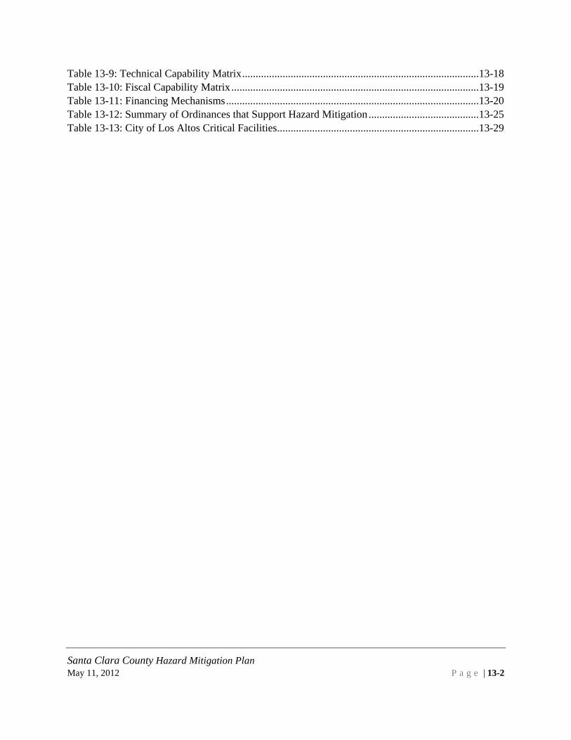
Santa Clara County Hazard Mitigation Plan May 11, 2012 Page | 13-1 Contents Section 13 City of Los Altos Annex ............................................................................................13-3 13.1 Introduction........................................................................................................................13-3 13.2 Internal Planning Process ..................................................................................................13-7 13.3 Capability Assessment .....................................................................................................13-14 13.3.1 Mitigation Progress ..................................................................................................13-14 13.3.2 Staff and Organizational Capabilities ......................................................................13-16 13.3.3 National Flood Insurance Program ..........................................................................13-27 13.3.4 Resource List: ..........................................................................................................13-29 13.4 Vulnerability Assessment ................................................................................................13-29 13.4.1 Critical Facilities ......................................................................................................13-29 13.4.2 Exposure Analysis....................................................................................................13-30 13.5 Mitigation Strategy ..........................................................................................................13-49 13.5.1 Primary Concerns.....................................................................................................13-49 13.5.2 Mitigation Actions ...................................................................................................13-49 13.6 Plan Maintenance.............................................................................................................13-53 13.6.1 Monitoring, evaluating, updating the plan ...............................................................13-53 13.6.2 Point of Contact .......................................................................................................13-53 13.7 City of Los Altos Appendix.............................................................................................13-54 13.7.1 Los Altos Attachment 1: Outreach Materials...........................................................13-54 13.7.2 Los Altos Attachment 2: Los Altos Strategies 2010 ................................................13-56 13.7.3 Los Altos Attachment 3: Los Altos Exposure Analysis...........................................13-58 Figure 13-1: Inventory of Soft-First Story Multi-Family Dwellings-City of Los Altos .................13-39 Table 13-1: Hazards of Most Concern ..............................................................................................13-8 Table 13-2: Items Readily Available to Respondents .......................................................................13-9 Table 13-3: Adequate Homeowners Insurance ...............................................................................13-11 Table 13-4: Earthquake Insurance ..................................................................................................13-11 Table 13-5: Flood Insurance ...........................................................................................................13-11 Table 13-6: Property Changes to Reduce Future Damage from Hazards .......................................13-12 Table 13-7: Place of Work in Hazard Areas ...................................................................................13-12 Table 13-8: Key Departments in the City of Los Altos ..................................................................13-16
-
Upload
hoangquynh -
Category
Documents
-
view
213 -
download
0
Transcript of Contentsresilience.abag.ca.gov/wp-content/documents/2010LHMP/LosAltos... · Contents Section 13...

Santa Clara County Hazard Mitigation Plan May 11, 2012 P a g e | 13-1
Contents Section 13 City of Los Altos Annex ............................................................................................ 13-3
13.1 Introduction........................................................................................................................ 13-3
13.2 Internal Planning Process .................................................................................................. 13-7
13.3 Capability Assessment ..................................................................................................... 13-14
13.3.1 Mitigation Progress .................................................................................................. 13-14
13.3.2 Staff and Organizational Capabilities ...................................................................... 13-16
13.3.3 National Flood Insurance Program .......................................................................... 13-27
13.3.4 Resource List: .......................................................................................................... 13-29
13.4 Vulnerability Assessment ................................................................................................ 13-29
13.4.1 Critical Facilities ...................................................................................................... 13-29
13.4.2 Exposure Analysis .................................................................................................... 13-30
13.5 Mitigation Strategy .......................................................................................................... 13-49
13.5.1 Primary Concerns ..................................................................................................... 13-49
13.5.2 Mitigation Actions ................................................................................................... 13-49
13.6 Plan Maintenance............................................................................................................. 13-53
13.6.1 Monitoring, evaluating, updating the plan ............................................................... 13-53
13.6.2 Point of Contact ....................................................................................................... 13-53
13.7 City of Los Altos Appendix ............................................................................................. 13-54
13.7.1 Los Altos Attachment 1: Outreach Materials ........................................................... 13-54
13.7.2 Los Altos Attachment 2: Los Altos Strategies 2010 ................................................ 13-56
13.7.3 Los Altos Attachment 3: Los Altos Exposure Analysis ........................................... 13-58
Figure 13-1: Inventory of Soft-First Story Multi-Family Dwellings-City of Los Altos ................. 13-39 Table 13-1: Hazards of Most Concern .............................................................................................. 13-8 Table 13-2: Items Readily Available to Respondents ....................................................................... 13-9 Table 13-3: Adequate Homeowners Insurance ............................................................................... 13-11 Table 13-4: Earthquake Insurance .................................................................................................. 13-11 Table 13-5: Flood Insurance ........................................................................................................... 13-11 Table 13-6: Property Changes to Reduce Future Damage from Hazards ....................................... 13-12 Table 13-7: Place of Work in Hazard Areas ................................................................................... 13-12 Table 13-8: Key Departments in the City of Los Altos .................................................................. 13-16
Santa Clara County Hazard Mitigation Plan May 11, 2012 P a g e | 13-2
Table 13-9: Technical Capability Matrix ........................................................................................ 13-18 Table 13-10: Fiscal Capability Matrix ............................................................................................ 13-19 Table 13-11: Financing Mechanisms .............................................................................................. 13-20 Table 13-12: Summary of Ordinances that Support Hazard Mitigation ......................................... 13-25 Table 13-13: City of Los Altos Critical Facilities ........................................................................... 13-29

Santa Clara County Hazard Mitigation Plan May 11, 2012 P a g e | 13-3
SECTION 13 CITY OF LOS ALTOS ANNEX 13.1 INTRODUCTION This City of Los Altos Annex serves as an annex to the Santa Clara County Local Hazard Mitigation Plan which is an annex to the 2010 Association of Bay Area Local Hazard Mitigation Plan, Taming Natural Disasters. Pursuant to the Disaster Mitigation Act of 2000, a signed adoption resolution confirms the City Council adopted this annex. The City of Los Altos has not previously prepared a local hazard mitigation plan pursuant to the Disaster Mitigation Act of 2000, therefore this is not an update, and should be reviewed as a new plan.
The City of Los Altos is a small city located in the northwestern region of Santa Clara County, California. The City has a population of 28,976 people, based on the 2010 census. Los Altos strives to maintain a semi-rural atmosphere with a minimum lot size for most residential housing at one-quarter of an acre. The civic center sits in the middle of an orchard, a remnant of those that once covered the area. Many Los Altos homes draw a price of $2 million and higher, putting the city (along with neighboring Los Altos Hills, with which it shares ZIP codes) at numbers 24 and 28 on Forbes'
"Most Expensive ZIP Codes in America" list in 2007. Los Altos is near the San Andreas Fault and subject to earthquakes.
• 1906 San Francisco Earthquake - Although Los Altos was hit extremely hard (VIII on the intensity level), the main local effort was to help rebuild nearby Santa Cruz, which was nearly destroyed.
• 1989 — On October 17, Los Altos experienced the Loma Prieta earthquake, but avoided major damage. Los Altos and its churches combined efforts to clean up hard-hit areas such as Watsonville and Santa Cruz.

Santa Clara County Hazard Mitigation Plan May 11, 2012 P a g e | 13-4
This page intentionally left blank.
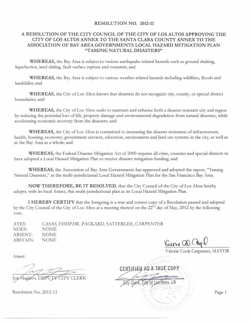
RESOLUTION NO. 2012-11
A RESOLUTION OF THE CITY COUNCIL OF THE CITY OF LOS ALTOS APPROVING THECITY OF LOS ALTOS ANNEX TO THE SANTA CLARA COUNTY ANNEX TO THE
ASSOCIATION OF BAY AREA GOVERNMENTS LOCAL HAZARD MITIGATION PLAN"TAMING NATURAL DISASTERS"
WHEREAS, the Bay Area is subject to various earthquake-related hazards such as ground shaking,liquefaction, land sliding, fault surface rupture and tsunamis; and
WHEREAS, the Bay Area is subject to various weather-related hazards including wildfires, floods andlandslides; and
WHEREAS, the City of Los Altos knows that disasters do not recognize city, county, or special districtboundaries; and
WHEREAS, the City of Los Altos seeks to maintain and enhance both a disaster-resistant city and regionby reducing the potential loss of life, property damage and environmental degradation from natural disasters, whileaccelerating economic recovery from the disasters; and
WHEREAS, the City of Los Altos is committed to increasing the disaster resistance of infrastructure,health, housing, economy, government services, education, environment and land use systems in the city, as well asin the Bay Area as a whole; and
WHEREAS, the Federal Disaster Mitigation Act of 2000 requires all cities, counties and special districts tohave adopted a Local Hazard Mitigation Plan to receive disaster mitigation funding; and
WHEREAS, the Association of Bay Area Governments has approved and adopted the report, "TamingNatural Disasters," as the multi-jurisdictional Local Hazard Mitigation Plan for the San Francisco Bay Area.
NOW THEREFORE, BE IT RESOLVED, that the City Council of the City of Los Altos herebyadopts, with its local Annex, this multi-jurisdictional plan as its Local Hazard Mitigation Plan.
I HEREBY CERTIFY that the foregoing is a true and correct copy of a Resolution passed and adoptedby the City Council of the City of Los Altos at a meeting thereof on the 22nd day of May, 2012 by the followingvote:
AYES:NOES:ABSENT:ABSTAIN:
CASAS, FISHPAW, PACKARD, SATTERLEE, CARPENTERNONENONENONE
Valotie Cook Carpenter, MAYORAttest:
Resolution No. 2012-11 ~~-~~'.-"- ~-- -
Page 1

Santa Clara County Hazard Mitigation Plan May 11, 2012 P a g e | 13-6
This page intentionally left blank.

Santa Clara County Hazard Mitigation Plan May 11, 2012 P a g e | 13-7
13.2 INTERNAL PLANNING PROCESS The City of Los Altos participated in the regional planning process coordinated by ABAG and the local planning process coordinated by Santa Clara County OES, as noted in Section 3 of this plan. Matthew Hartley, Sergeant, served as the City’s representative and lead for completing this annex. Andy Galea, Captain, participated in Local Planning Team meetings #1 and #2, and assisted Mr. Hartley in facilitating the City’s public outreach for the online survey, performing internal reviews and collaborating in order to provide all of the required information for development of this annex. Matt Hartley participated in Local Planning Team meeting #3, coordinated internal reviews of the draft annex, distribution of the review draft, and adoption of the conditionally approved annex. Contact information: Sergeant Paul Arguelles, [email protected], 650-947-2663 The City of Los Altos’ internal planning team included the following individuals:
Tuck Younis, Chief of Police Andy Galea, Police Captain
Matthew W. Hartley, Police Sergeant Paul Arguelles, Police Sergeant
Brian J. McCarthy, Maintenance Services Manager David Kornfield, Planning Services Manager Kirk Ballard, Building Official Public Outreach The City of Los Altos notified residents and businesses of the hazard mitigation planning process by distributing promotional announcements regarding the public opportunity to respond to the online survey discussed in Section 3.2.6 in the County Annex. A copy of the survey is included in County Attachment 7: Survey Outreach Materials, found in Section 9.7. The following media was utilized:
• City Website (www.ci.los-altos.ca.us/) • Los Altos Town Crier newspaper
Copies of these outreach announcements are included in Section 13.7, Los Altos Attachment 1: Outreach Materials. Survey Results On November 1, 2010, the Local Planning Team released an online survey to solicit public input regarding concerns for hazard risk. The Local Planning Team also used this survey to gauge the level of public preparedness for emergencies. The survey responses received from the City of Los Altos residents are summarized below:

Santa Clara County Hazard Mitigation Plan May 11, 2012 P a g e | 13-8
1. 13 out of 541 survey respondents were from the City of Los Altos. 2. Respondents were asked which five hazards, out of the 31 hazards the LPT identified, are of
most concern to their neighborhood or home. Below are responses from the City of Los Altos (in order of most responses):
Table 13-1: Hazards of Most Concern Hazard Number of Responses Earthquake: Ground Shaking 10 Infrastructure: Water System Disruption (no potable water) 10 Infrastructure: Electrical System Disruption (no power) 8 Infrastructure: Telecommunication System Disruption (no phone / cell service) 5
Infrastructure: Transportation Disruption (blocked roads / failed bridges) 4 Disease and Outbreak 3 Earthquake: Surface Rupture 3 Flood 3 Infrastructure: Energy System Disruption (no gas) 3 Infrastructure: Wastewater System Disruption (sewer backup) 3 Additional Hazard * 3 Hazardous Materials Spills (chemical/biological) 2 Wildfire 2 Wind (high winds) 2 Agricultural Pests and Diseases 1 Dam Failure 1 Drought 1 Bay Area Silting 0 Delta Levee Failure 0 Earthquake: Landslides 0 Earthquake: Liquefaction 0 Expansive Soils 0 Freeze 0 Hailstorm 0 Heat (extreme heat) 0 Land Subsidence (soil compaction due to subsurface water removal) 0 Landslide and Debris flow 0 Solar Storm 0 Thunder/Lightning Storms 0 Tornado 0 Tsunami 0 Volcano 0

Santa Clara County Hazard Mitigation Plan May 11, 2012 P a g e | 13-9
* Respondents noted the following additional hazards: personal and property safety if police protection is not available and downed power lines 3. Respondents were asked if a severe hazard event occurred today, such that all services were cut off from their home and they were unable to leave or access a store for 72 hours, which items they would have readily available. Below is a summary of responses from the City of Los Altos respondents:
Table 13-2: Items Readily Available to Respondents Item that is Readily Available Responses Blanket(s) 11 Flashlight (with batteries) 11 Canned/Non-perishable Foods (ready to eat) 11 First Aid Kit 10 Portable AM/FM Radio (solar powered, hand crank,or batteries) 10 Potable Water (3 gallons per person) 9 Cash 8 Extra Medications 8 What else do you have in your emergency kit? * 7 Handheld “Walkie-Talkie” Radios (with batteries) 3 Important Family Photos/Documentation in a water and fire proof container 3
* Respondents noted the following additional items in their emergency kits: hand warmers, portable toilet and toilet paper, propane stove, tarps, sleeping bags, outdoor clothes, shoes, ID, keys, cell phone, whistle, water bottle, 2-story chain ladder, tent, shovels, tools, garbage bags, lantern, fuel, extra batteries, mountain bikes, government emergency preparedness publications, vital records PortaVault system, pet food 4. Respondents were asked if they were familiar with the special needs of their neighbors in the event of a disaster situation.
• 8, or 61.5% of respondents, answered that they are not familiar with the special needs of their neighbors.
• 5, or 38.5% of respondents, answered that they are familiar with the special needs of their neighbors.
5. Respondents were asked if they are trained members of their Community Emergency Response Team (CERT) *The City of Los Altos no longer provides CERT training.
• 7, or 53.8% of respondents indicated that they are part of CERT. • 6, or 46.2% of respondents, indicated that they are not part of CERT, but would like to
learn more about CERT.

Santa Clara County Hazard Mitigation Plan May 11, 2012 P a g e | 13-10
• None of the respondents indicated that they are not part of CERT and are not interested in being a trained CERT member.
Respondents were asked to share why they are a trained CERT member, or why they are not part of CERT. The received responses are listed below:
• As a current Los Altos Councilwoman, I thought it was important to get CERT training • The City of Los Altos is not offering the program • We are elderly and our activities have been limited by illness during the last several months.
But we hope at least one of us can attend classes if possible in 2011. • Yes, but need a refresher • Trained in CERT by Los Altos Police. Wanted to be better prepared to help my family and
neighbors in case of an emergency. Would also like to become a HAM operator. • I am a trained animal disaster responder with the Humane Society. To become more familiar
with local emergency response procedures, I completed CERT training in Mountain View in 2008.
6. Respondents were asked what is the most important thing local government can do to help communities be more prepared for a disaster. The following summarizes the 11 responses received:
• More CERT training along with refresher sessions • Ensure personal and property protection against crime during and after a major
disaster • Institute automatic email, text messages, and phone calls in an emergency (Emergency
Communication) • Promote awareness • Citizen training and outreach • Emergency Preparedness information • Develop community response teams • Fuel backup
7. Respondents were asked if they live in an apartment building or home with a living space above a garage or parking area.
• 7 or 58.3% of respondents indicated that they do not live in an apartment or home with living space above a garage or parking area.
• 5, or 41.7% of respondents, indicated that they do live in an apartment building or home with living space above a garage or parking area.
• One respondent skipped this question. Those respondents who indicated that they do live in an apartment building or home with living space above the garage or parking area were asked to describe their level of concern for the building to collapse in a large earthquake event. 2 respondents indicated that they have “Moderate Concern”, while 2 respondents indicated that they have “No Concern”.

Santa Clara County Hazard Mitigation Plan May 11, 2012 P a g e | 13-11
8. Respondents who are homeowners were asked if they have adequate homeowners insurance to cover the hazards that could impact their home. Below is a summary of responses:
Table 13-3: Adequate Homeowners Insurance Answer Responses Yes, my insurance coverage should be adequate 8 No, I don't believe my insurance coverage would be adequate for a major disaster 1 Unsure 1 I do not have an insurance policy 0 Not applicable, I rent my current residence 0
9. Respondents were asked if they have earthquake insurance. Below is a summary of responses:
Table 13-4: Earthquake Insurance Answer Responses Yes, I own my home and have earthquake insurance. 2 Yes, I rent my home and have earthquake insurance. 0 No, but I am interested in reviewing earthquake insurance options. 3 No, earthquake insurance is too expensive. 7 No, I do not need earthquake insurance. 0
10. Respondents were asked if they have flood insurance. Below is a summary of responses:
Table 13-5: Flood Insurance Answer Responses Yes, I own my home and have flood insurance. 1 Yes, I rent my home and have flood insurance. 0 No, but I am interested in reviewing flood insurance options. 1 No, I do not need flood insurance 10
11. Respondents indicated the following as additional insurance listed for their home or property:
• Standard home insurance plus a rider for water damage in basement • Liability • Condominium owner’s insurance for personal possessions and interior decor
12. Respondents were asked what they are doing to their property or within their home to reduce future damage from the hazards identified above. Below is a summary of responses:

Santa Clara County Hazard Mitigation Plan May 11, 2012 P a g e | 13-12
Table 13-6: Property Changes to Reduce Future Damage from Hazards Property Mitigation Responses Seismic retrofit of the structure and/or foundation 3 Roof retrofit using fire resistant material 3 Other * 2 Installed backflow prevention devices 2 Defensible space landscaping (clear vegetation around house to reduce wildfire risk) 1 Strengthened Openings (to reduce high hazard wind risk) 1 House elevation or first floor modification to prevent flood damage 1
*The responses to “Other” were: “Monitored security system and natural gas powered generator” and “Our HOA meets regularly to discuss such issues and solve any problems.” 13. Respondents were asked if they work in Santa Clara County.
• 7, or 58.3% of respondents, indicated that they do work in Santa Clara County. • 5, or 41.7% of respondents, indicated that they do not work in Santa Clara County.
14. Respondents were asked if their place of work is in an area susceptible to natural hazards. Below is a list of natural hazards and responses from survey respondents:
Table 13-7: Place of Work in Hazard Areas Natural Hazard Response Earthquake fault zone 7 Other * 3 High-risk flood zone 2 I don’t know 1 Liquefaction zone 1 Landslide Risk Area 0 Wildland Urban Interface (wildfire risk area) 0
* The response to “other” was: tsunami 15. Respondents were asked if their employer has a plan for disaster recovery in place.
• 7, or 87.5% of respondents, indicated that their employer does have a disaster recovery plan in place.
• 1, or 12.5% of respondents, indicated that their employer does not have a disaster recovery plan in place.
• 5 respondents skipped this question.

Santa Clara County Hazard Mitigation Plan May 11, 2012 P a g e | 13-13
16. Respondents were asked if their employer has a workforce communications plan to implement following a disaster so they may contact their employees.
• 5, or 62.5% of respondents indicated that their employer does have a workforce communications plan.
• 1, or 12.5% of respondents indicated that their employer does not have a workforce communications plan.
• 2, or 25% of respondents indicated that they are unsure if their employer has a workforce communications plan.
• 5 respondents skipped this question. 17. Respondents were asked to list any studies that they are aware of being conducted within their community or the county regarding the risk to future hazard events. 3 respondents replied to this question. These answers are summarized below. 10 respondents skipped this question.
• Articles about CERT in local newspaper • SCC, SCVWD, the USGS, the SFPUC, and the WRCB Division of Dams have done studies
on potential local hazard events.
18. Respondents were asked what recommendations they have for Santa Clara County and the incorporated cities to improve identification, prioritization, and implementation of actions intended to reduce future damage and increase resiliency. The following recommendations were received:
• Develop a list of priorities in the event of a major disaster • Help the injured get professional care • Have emergency shelters, safe water, and food in place • Protect people and property from crime • Restore infrastructure • Move power utilities underground • Make sure CalWater has an adequate emergency response plan
19. Respondents were asked to recommend any companies or local associations that should be involved in the Santa Clara County hazard mitigation planning process. The recommended organizations are listed below and were given the opportunity to review the draft plan as noted in the following section.
• Los Altos Chamber of Commerce • CalWater • San Jose Water Company
20. Respondents were asked if they would like to review and comment on a draft of their jurisdictions annex to the Multi-Jurisdictional Multi-Hazard Mitigation Plan.
• 5, or 55.6% of respondents said they would like to review and comment on the draft plan.
Santa Clara County Hazard Mitigation Plan May 11, 2012 P a g e | 13-14
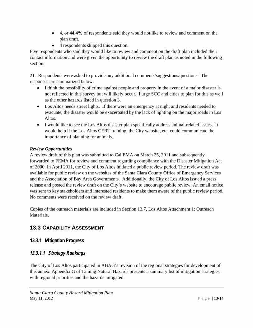
• 4, or 44.4% of respondents said they would not like to review and comment on the plan draft.
• 4 respondents skipped this question. Five respondents who said they would like to review and comment on the draft plan included their contact information and were given the opportunity to review the draft plan as noted in the following section. 21. Respondents were asked to provide any additional comments/suggestions/questions. The responses are summarized below:
• I think the possibility of crime against people and property in the event of a major disaster is not reflected in this survey but will likely occur. I urge SCC and cities to plan for this as well as the other hazards listed in question 3.
• Los Altos needs street lights. If there were an emergency at night and residents needed to evacuate, the disaster would be exacerbated by the lack of lighting on the major roads in Los Altos.
• I would like to see the Los Altos disaster plan specifically address animal-related issues. It would help if the Los Altos CERT training, the City website, etc. could communicate the importance of planning for animals.
Review Opportunities A review draft of this plan was submitted to Cal EMA on March 25, 2011 and subsequently forwarded to FEMA for review and comment regarding compliance with the Disaster Mitigation Act of 2000. In April 2011, the City of Los Altos initiated a public review period. The review draft was available for public review on the websites of the Santa Clara County Office of Emergency Services and the Association of Bay Area Governments. Additionally, the City of Los Altos issued a press release and posted the review draft on the City’s website to encourage public review. An email notice was sent to key stakeholders and interested residents to make them aware of the public review period. No comments were received on the review draft. Copies of the outreach materials are included in Section 13.7, Los Altos Attachment 1: Outreach Materials. 13.3 CAPABILITY ASSESSMENT 13.3.1 Mitigation Progress 13.3.1.1 Strategy Rankings The City of Los Altos participated in ABAG’s revision of the regional strategies for development of this annex. Appendix G of Taming Natural Hazards presents a summary list of mitigation strategies with regional priorities and the hazards mitigated.

Santa Clara County Hazard Mitigation Plan May 11, 2012 P a g e | 13-15
The City ranked those strategies in a spreadsheet provided by ABAG using the following scale: Existing Program Existing Program, Underfunded Very High – Unofficial Program – Becomes Official on Plan Adoption, No Funding Needed High – Actively Looking for Funding Moderate Under Study Not Applicable, Not Appropriate, or Not Cost Effective Not Yet Considered
Results of this ranking may be viewed online at http://www.abag.ca.gov/bayarea/eqmaps/mitigation/strategy.html. A summary of these rankings is presented in Los Altos Attachment 2: Los Altos Strategies 2010, in Section 13.7. The countywide Local Planning Team reviewed the priorities as ranked by the participating Santa Clara County jurisdictions to determine the operational area goals and objectives. The City of Los Altos is primarily concerned with potential impacts from Stevens Creek Dam failing and unmapped faults under Foothill College. Wildfire and riverine flooding are the other two main hazards of concern. The concern for wildfire is related to the neighboring jurisdiction of Los Altos Hills where residences are located in the wildland urban interface. The City has a good floodplain management ordinance to mitigate risk to riverine flooding. New mitigation actions the City of Los Altos has identified are discussed in Section 13.5. 13.3.1.2 Completed projects The City of Los Altos has ensured there are no remaining unreinforced masonry buildings within the City. All structures have been seismically retrofitted. The Building Official has required more restrictive fire sprinklers regulations through the adoption of the 2007 California Code of Regulations. Amendments include required fire suppression systems to be installed in all new buildings and substantial addition/remodels, both for commercial and residential buildings since 3/1/08. The Building Official has required more restrictive code regulations for lateral and uplift braced wall designs. These were amended back in the 1994 California Building Code. The Building Official has continued these more restrictive regulations for Los Altos as modified again in the 2010 adoption of the California Code of Regulations effective 01/01/11. The Building Official has required more restrictive code regulations with regard to the 2010 California Plumbing Code. State Architect approved Earthquake Actuated Gas Shut off Valves are required on all new, replaced, repaired, and relocated gas meters.

Santa Clara County Hazard Mitigation Plan May 11, 2012 P a g e | 13-16
Seismic Retrofit plans are available to the public for no cost through the Building Official. These plans facilitate retrofitting existing wood framed buildings without having the associated costs of hiring a California Licensed Engineer or Architect. 13.3.1.3 Current projects The City is currently trying to incorporate liquefaction concerns into the building process. A revised Civic Center Master Plan to replace all government buildings is presently under consideration. When the funding is available, the Building Official would like to allow grant monies for owners of soft story buildings (this law is in the making similar to URM requirements in the 1990’s). In addition, they would like to inspect structures owned by the City of Los Altos for possible seismic retrofit and/or replacements. Los Altos believes that the City Engineering Division/Public Works should take the lead on this subject. This is listed as a mitigation action in Section 13.5. 13.3.2 Staff and Organizational Capabilities 13.3.2.1 Departmental Responsibilities The City of Los Altos operates several departments with capabilities for implementing hazard mitigation strategies. These departments and their roles and responsibilities are summarized in the following table.
Table 13-8: Key Departments in the City of Los Altos Key Departments in the City of Los Altos
Departments
Public Safety (Police and Fire) Personal Emergency Preparedness (PEP) The mission of PEP is to harness the power of every individual through education, training, and volunteer service to make communities safer, stronger, and better prepared to respond to the threats of terrorism, crime, public health issues and disasters of all kinds. Community Development Department The Community Development Department works to promote the orderly development of the community while preserving and enhancing the City's appearance and its distinct character. The Department also ensures that all projects within the City, both public and private, are constructed and maintained in a safe and legal environment. The Community Development Department is divided into three divisions.

Santa Clara County Hazard Mitigation Plan May 11, 2012 P a g e | 13-17
o Planning Division The Planning Division is responsible for the development and administration of programs to guide the physical development of Los Altos, utilizing the General Plan, a variety of neighborhood Specific Plans and the City's Zoning Ordinance for policy guidance. The Division provides design and environmental review of development proposals and general public information services. The Division provides staffing to the Architecture and Site Review Committee, the Board of Adjustments, the Planning Commission, the Historical Commission, and the City Council with analyses and recommendations on development applications. Planning staff also works with the Code Enforcement Officer when necessary to document and correct building violations. o Building Division The Building Division is responsible for performing architectural and structural plan checks, scheduling and performing building inspections and providing general customer information services. The Division is responsible for administering the Uniform Building Codes and other applicable development regulations. Building staff also works with the Code Enforcement Officer when necessary to document and correct building violations. o Engineering Division The Public Works Department is responsible for the development and maintenance of the City's parks, buildings, bridges, streets, traffic signals, and wastewater/storm drain collection systems, as well as administration of the solid waste collection and recycling contract service. The Department is divided into two divisions, Engineering and Maintenance. The Engineering Division oversees the City's long-range capital improvement program and provides all engineering, bidding and construction administration for City infrastructure. The Engineering Division also provides traffic-engineering services including administration of - the Neighborhood Traffic Management Program. The Maintenance Division oversees the contracts for street sweeping and performs maintenance of the sanitary sewer collection system, storm drain system, parks, trees, and streets throughout the City.
With a clear hazard mitigation strategy, as outlined in this Local Hazard Mitigation Plan, the City’s departments are able to implement their ongoing policies and programs with consideration of the identified hazard risks. In addition, these departments become aware of priority mitigation actions and can offer resources (financial or staffing) to assist with the implementation of those actions.

Santa Clara County Hazard Mitigation Plan May 11, 2012 P a g e | 13-18
13.3.2.2 Technical Capability For a successful mitigation program, it is necessary to have a diverse breadth of staff and technical capabilities. Planners, engineers, building inspectors, emergency managers, floodplain managers, people familiar with Geographic Information Systems (GIS), and grant writers are all essential to implementing mitigation actions. The following table summarizes the staffing capabilities available within the City of Los Altos.
Table 13-9: Technical Capability Matrix
Technical Capability Matrix
Land Use Planners Planning Division
Emergency manager Administration and Public Safety
Civil or Building Engineers Engineering Division
Floodplain manager Engineering and Planning Divisions
Staff knowledgeable about hazards
Public Safety, Engineering and Planning Division
GIS staff Engineering and Planning Divisions
Grant writers Engineering Division
13.3.2.3 Fiscal Capability The following pie charts and tables summarize Los Altos’ fiscal capabilities in terms of the City’s financial resources and allocated spending (2011 data).

Santa Clara County Hazard Mitigation Plan May 11, 2012 P a g e | 13-19
Table 13-10: Fiscal Capability Matrix
Fiscal Capability Matrix
Total General Fund
(Beginning Balance)
Total Capital Improvement Funds
Total Enterprise Funds
Total Special Revenue Funds
Total Internal Service Funds
Total Debt Service Funds
Total Budget
7,280,340 4,073,583 2,878,107 8,686,810 1,700,032 415,063 22,914,822

Santa Clara County Hazard Mitigation Plan May 11, 2012 P a g e | 13-20
Table 13-11: Financing Mechanisms Financing Mechanisms
Taxes Recreation Fees
Interest and Rent
Planning and Building
Franchise Fees
Police Fees
Other Fees Total
19,769,710 1,939,240 458,000 2,243,000 1,168,120 95,650 1,612,190 27,745,970
13.3.2.4 Policy or Program Capability The City of Los Altos has several plans and ordinances in place which provide ample opportunities for implementing the hazard mitigation strategy outlined in this plan.
13.3.2.4.1 Summary of Plans that Support Hazard Mitigation Emergency Operations Plan The purpose of Los Altos’ Emergency Operations Plan (EOP) is to protect the safety and welfare of the citizens, as well as all employees and visitors in the City of Los Altos. The EOP is divided into four sections. The first section is the Basic Plan. The Basic Plan addresses the City’s responsibilities in emergencies associated with natural disaster, human-caused emergencies and technological incidents. It provides a framework for coordination of response and recovery efforts within the City and with local, State, and federal agencies as well as volunteer organizations. The Plan establishes an emergency organization to direct and control operations during a period of emergency by assigning responsibilities to specific personnel. In short, the Basic Plan
• Conforms to the State mandated Standardized Emergency Management System (SEMS), the National Incident Management System (NIMS), and effectively structures emergency response at all levels in compliance with the Incident Command System (ICS).
• Establishes response policies and procedures, providing the City with clear guidance for planning purposes.
• Describes and details procedural steps necessary to protect lives and property. • Outlines coordination requirements. • Provides a basis for unified training and response exercises to ensure compliance.
The Basic Plan indicates that there are four emergency phases: Mitigation, Preparedness, Response, and Recovery. During the mitigation phase, actions are taken to strengthen facilities to reduce the potential damage to structures and/or their contents. The Plan states that mitigation can create a safer environment that will result in lower response costs and fewer casualties. The preparedness phase involves emergency personnel reviewing the EOP, standard operating procedures, and checklists before the upcoming emergency. The response phase is broken into three categories: pre-impact,

Santa Clara County Hazard Mitigation Plan May 11, 2012 P a g e | 13-21
immediate impact, and sustained. Pre-impact involves activating warning systems and the EOC and possibly evacuating residents. During immediate impact, emphasis is placed on saving lives, controlling the situation, and minimizing the effects of the disaster. Under the sustained category, assistance is provided to victims of the disaster and efforts are made to reduce secondary damage. Lastly, the recovery phase involves taking all actions necessary to restore the area to pre-event conditions or better. Mitigation for future hazards is an important part in the recovery phase. The Hazard Vulnerability Assessment and Risk Analysis section of the Basic Plan identifies the hazards that threaten the City. Natural hazards include earthquakes, floods, wildland fires, landslides, and extreme weather and storms. Man-made hazard include hazardous materials, major vehicle accidents, dam failure, airplane crash, civil disturbance, and terrorism. This section of the EOP includes a hazard matrix that outlines each of the identified hazards, their likelihood of occurrence, and their severity. The location of these hazards in Los Altos is described in this section. Mitigation actions are also indicated in the Hazard Vulnerability Assessment and Risk Analysis section. To mitigate earthquakes, the City will continue to promote earthquake preparedness in the community through its Emergency Preparedness Plan and exercises coordinated through the City’s Emergency Manager. Flood mitigation includes the City’s participation in the National Flood Insurance Program. The City will further reduce the potential for flood hazard damage by implementing the adopted flood hazard area regulations for FEMA designated floodways, mudflow prone areas, and flood-related erosion prone areas. To prevent fire damages, the City will coordinate with the Santa Clara County Fire Department to implement fire hazard education and fire protection programs. The City will also ensure that construction is consistent with the current Uniform Fire Code and that water pressure is adequate for firefighting purposes. To mitigate hazardous waste incidents, generators and users in the City are required to comply with federal, state, and county regulations. The Hazardous Materials Compliance Division of the County Environmental Health Services Department ensures compliance and reporting in accordance with the Santa Clara County Hazardous Waste Management Plan. A main objective of the EOP is to define the City’s Emergency Operations Center (EOC), explain its role for emergency response, indicate when the EOC should become active during an emergency, and set guidelines for the EOC’s response to specific emergencies. Section 2 of this EOP is dedicated to describing the role and responsibility of the EOC, while Section 3 includes EOC checklists for each representative in the EOC. In addition, Appendix 2 includes hazard specific checklists, which indicate who is responsible and what is to be done during a specific hazard. The Director of Emergency Services (City Manager) is assigned the responsibility of reviewing and updating the EOP annually. In order to prepare for disasters, the City will conduct an EOC table top or an EOC functional exercise at least once a year, simulating an actual incident or disaster. If the EOC is activated for a declared emergency, the City will prepare an After Action Report that includes corrective actions for the future.

Santa Clara County Hazard Mitigation Plan May 11, 2012 P a g e | 13-22
General Plan Today, Los Altos is a community grounded in the unique history of its agricultural and railroad culture, yet it is also a community of the 21st century that is prepared to face the challenges ahead. To meet these challenges, the General Plan for Los Altos is the primary source of long-range planning and policy direction that will be used to guide growth and preserve the quality of life within the community. Los Altos’ General Plan facilitates hazard mitigation in several ways. Following is a brief summary of three General Plan Elements highlighting the capabilities for implementing and supporting hazard mitigation. Natural Environmental and Hazards Element Natural events and conditions such as earthquakes, landslides, flooding, and fire can endanger human life and property. Los Altos uses the term Natural Environmental and Hazards Element to address safety issues in the General Plan. Top ranking priorities of defining community characteristics were: 1) Safety in the Downtown area. 2) Safety in neighborhoods. 3) Safety in families. Re-occurring themes included balanced development (village atmosphere vs. new development), community involvement, neighborhood preservation, public safety, quality education, and youth development. This element outlines several goals. The first of which focuses on minimizing risks of personal injury and property damage associated with seismic activity, landslides, and other geologic hazards. The following policies listed in the Safety Element document how Los Altos intends to achieve this goal: Policy 1.1: Update acceptable levels of risk/life safety standards when necessary, and see that buildings are brought up to those standards, consistent with state law. Policy 1.2: Avoid placement of critical facilities and high occupancy structures in areas known to be prone to ground failure during an earthquake. Policy 1.3: Require soil analysis and erosion mitigation for all development proposed on sites know to be prone to erosion or ground failure. The community of Los Altos is subject to periodic flooding hazards. Natural flooding results from overflow along the City’s four creeks during major rainstorms. While in the past, creek flooding was addressed through channelization to increase the capacity of the creeks, the City prefers to preserve the natural resources along the creek beds and use less intrusive methods to minimize flooding hazards. Other flooding related hazards within the City include dam inundation if the Stevens Creek Dam fails, and potential mud and debris flow during rain storms on the few hillsides within the planning area.

Santa Clara County Hazard Mitigation Plan May 11, 2012 P a g e | 13-23
Land Use Element The purpose of the Land Use Element is to describe existing and future land use activity, which has been designed to achieve the City’s long-range goals for physical development. The Element also addresses the relationship between development and environmental quality, potential hazards, and social and economic objectives. Land use planning takes into consideration housing needs identified in the Housing Element, natural and manmade hazards and development constraints identified in the Natural Environment & Hazards Element, and the open space and conservation policies outlined in the Open Space, Conservation& Community Facilities Element. The other General Plan elements ensure that infrastructure, utilities, and public facilities are available to accommodate planned land uses, and that the unique qualities of Los Altos are safeguarded and enhanced. Future Development The El Camino Real commercial corridor is located along the City’s northern edge, shared with the Cities of Mountain View and Palo Alto. Commercial property abutting this six-lane arterial road has been identified in the Land Use Element as one of the few areas with underutilized land and potential to redevelop or intensify existing development without jeopardizing the small-town residential character of the City. Housing Element Los Altos maintains the H-7 voluntary code inspection program encompassing code compliance, rehabilitation, energy conservation, and minimum fire safety standards. Los Altos will continue the voluntary code inspection program encompassing code compliance, rehabilitation, energy conservation, and minimum fire safety standards. Floodplain Management Plan The City of Los Altos has found that flood hazard areas within their jurisdiction are subject to periodic inundation which can result in the loss of life and property, health and safety hazards, disruption of commerce and governmental services, and public expenditures for flood protection and relief. The City has also found that these flood losses are caused by obstructions in areas of special flood hazard which can increase flood heights and velocities. Therefore, the purpose of the City’s Flood Hazard Area Regulations is to minimize expenditure of public money for costly flood-control projects, the need for rescue and relief efforts associated with flooding, prolonged business interruptions, and damage to public facilities and utilities. The ordinance also ensures that potential buyers are notified that property is in an area of special flood hazard and that those who occupy property in those areas are held responsible for their actions. A floodplain administer is responsible for the enforcement of this plan.

Santa Clara County Hazard Mitigation Plan May 11, 2012 P a g e | 13-24
To reduce flood losses, the ordinance includes methods and provisions to control the alteration of natural floodplains, stream channels, and protective barriers; to control filling, grading, dredging and other development that can increase flood damage; to regulate the construction of flood barriers that can divert floodwaters or increase flood hazards in other areas; and to require that uses vulnerable to floods be protected against flood damage at the time of their construction. One of the provisions of this ordinance is that a development permit must be obtained before construction or development occurs within any area of special flood hazard, area of flood-related erosion hazard, or area of mudslide/mudflow. Construction standards, such as anchoring, building with flood resistant materials, and elevating and flood-proofing, are also required. The ordinance enforces that new and replacement water and sanitary sewage systems should be designed to minimize flood water infiltration and discharge into flood waters. Since floodways are extremely hazardous due to the velocity of floodwaters, no new construction should be developed in these areas, unless certification by a registered civil engineer or architect is provided demonstrating that the proposed development will not increase flood levels. Standards are also included for subdivisions, manufactured homes, as well as for mudslide and flood erosion prone areas.

Santa Clara County Hazard Mitigation Plan May 11, 2012 P a g e | 13-25
Capital Improvements Plan There are several projects detailed in Los Altos’ Capital Improvement Plan (CIP) for the years 2009-2013 that could help mitigate potential hazards. Many of the projects listed in the CIP are to prevent traffic and pedestrian accidents from occurring. Street resurfacing projects, which also include repair to damaged curbs and gutters and minor drainage improvements, extend the life of existing street surfaces and may reduce traffic incidents. Adding a street slurry seal, a type of surface treatment, to roads is a preventative maintenance project that prevents moisture from penetrating the pavement and softening the base material supporting the pavement, thus also extending the life of roads in Los Altos and helping to reduce traffic incidents. Street striping projects improve the visibility of pavement markings, which is also important in preventing traffic accidents. In addition, concrete repair projects have a primary focus on replacing damaged sidewalks that represent hazards to pedestrians. Utility maintenance projects are also included in the City’s CIP. Annual sewer repair projects are undertaken by the City of Los Altos to prevent a utility mishap from occurring in the City. The City recently completed a CIP project by building a municipal service center fuel station, in order to provide an emergency fuel system in the event of a major disaster. The City believes that the emergency preparedness for both police and maintenance would be at a much higher level with the installation of the fuel tank.
13.3.2.4.2 Summary of Ordinances that Support Hazard Mitigation
Table 13-12: Summary of Ordinances that Support Hazard Mitigation Availability of Ordinances that Support Hazard Mitigation
Juri
sdic
tion
Floo
d D
amag
e Pr
even
tion
Ord
inan
ce
Zoni
ng
Ord
inan
ce
Subd
ivis
ion
Ord
inan
ce
Post
-dis
aste
r Re
d/Re
c.
Ord
inan
ce
Build
ing
Cod
e
Fire
Cod
e
Nat
iona
l Fl
ood
Insu
ranc
e Pr
ogra
m
NFI
P C
omm
unity
Ra
ting
Syst
em
City of Los Altos Yes Yes Yes Yes Yes Yes Yes
The City of Los Altos identified several ordinances and policies currently utilized for hazard mitigation in the matrix of regional mitigation strategies prepared by ABAG as part of the 2010 plan update. Below is a summary of these key ordinances and policies.

Santa Clara County Hazard Mitigation Plan May 11, 2012 P a g e | 13-26
General Plan The General Plan was identified as a method for implementing hazard mitigation strategies. The sections relevant to hazard mitigation are summarized in the General Plan section. Los Altos Municipal Code – Buildings and Construction There is hereby adopted by reference as if fully set forth herein, the 2007 edition of the California Code of Regulations, Title 24, Part 1, incorporating the California Administrative Code, published by the International Code Council, and each and all of its regulations and provision. One copy is on file for use and examination by the public in the office of the city clerk. This section includes the building, plumbing, mechanical, electrical, energy and fire codes among others. Specifically, the Fire Code states: The city council of the city of Los Altos hereby expressly finds that amendments to the California Fire Code adopted by this chapter and commencing with Section 12.24.080 are reasonably necessary for the protection of the public health, safety and welfare, due to the local climatic, geologic or topographical conditions specified as follows: The city of Los Altos experiences low humidity, high winds and warm temperatures during the summer months creating conditions which are particularly conducive to the ignition and spread of grass, brush and structure fires. Additionally, the city of Los Altos is geographically situated adjacent to active earthquake faults capable of producing substantial seismic events. Since the city of Los Altos is divided by creeks, an expressway and other substantial traffic corridors, the occurrence of a major earthquake would significantly impact the ability of fire crews to respond to emergencies should one or more bridges collapse or be substantially damaged. In addition, fire suppression capabilities would be severely limited should the water system be extensively damaged during the seismic event. Therefore, mitigation measures are necessary such as: automatic fire suppression systems, communications systems, access to buildings, seismic protection, safety controls for hazardous materials and other safe guards in order to minimize the risks to citizens, firefighters and property due to the severity of the fire threat and potential response delays. Los Altos Municipal Code – Flood Hazard Area Regulations The flood hazard areas of the city are subject to periodic inundation which can result in the loss of life and property, health and safety hazards, the disruption of commerce and governmental services, extraordinary public expenditures for flood protection and relief, and the impairment of the tax base, all of which adversely affect the public health, safety, and general welfare. Such flood losses are caused, among other things, by the cumulative effect of obstructions in areas of special flood hazard which increase flood heights and velocities and, when inadequately anchored, damage uses in other areas. Uses which are inadequately floodproofed, elevated, or otherwise protected from flood damage also contribute to the flood loss.

Santa Clara County Hazard Mitigation Plan May 11, 2012 P a g e | 13-27
In order to accomplish its purposes, this chapter includes methods and provisions for: A. Restricting or prohibiting uses which are dangerous to health, safety, and property due to water or erosion hazards or which result in damaging increases in erosion or in flood heights or velocities; B. Requiring that uses vulnerable to floods, including facilities which serve such uses, be protected against flood damage at the time of their initial construction; C. Controlling the alteration of natural floodplains, stream channels, and natural protective barriers which help accommodate or channel floodwaters; D. Controlling filling, grading, dredging, and other development which may increase flood damage; and E. Preventing or regulating the construction of flood barriers which will unnaturally divert floodwaters or which may increase flood hazards in other areas.
13.3.3 National Flood Insurance Program For decades, the national response to flood disasters was simply to provide disaster relief to flood victims. Funded by citizen tax dollars, this approach failed to reduce losses and didn't provide a way to cover the damage costs of all flood victims. To compound the problem, the public generally couldn't buy flood coverage from insurance companies, because private insurance companies consider floods too costly to insure. In the face of mounting flood losses and escalating costs of disaster relief to U.S. taxpayers, Congress established the National Flood Insurance Program (NFIP). The goals of the program are to reduce future flood damage through floodplain management, and to provide people with flood insurance. Community participation in the NFIP is voluntary. The City of Los Altos has participated in the National Flood Insurance Program since 1974. All residents of the City are eligible to purchase federal flood insurance. The City continues to maintain full compliance with the NFIP. There are no significant issues related to the community’s participation or the City’s implementation of the NFIP. The Building, Engineering and Planning Divisions share this responsibility. The City of Los Altos participates in the National Flood Insurance Program (NFIP) by:
o Maintaining Flood Hazard Area Regulations limiting and regulating construction in floodplain to a higher regulatory standard;
o Requiring and maintaining Elevation Certificates for construction within the floodplain;
o Providing floodplain map information to property owners, realtors, lenders and insurance agents;
o Providing periodic outreach to property owners within the floodplain; o Maintaining a list of floodplain management and flood protection documents in the
library;

Santa Clara County Hazard Mitigation Plan May 11, 2012 P a g e | 13-28
o Maintaining current floodplain maps and amendments, and special Santa Clara Water District floodplain studies;
o Managing stormwater runoff; o Coordinating with the Santa Clara Water District on flood prevention assistance and
open channel drainage system management; and o Participating in the Community Rating System for the National Flood Insurance
Program and maintaining a very good rating, thus qualifying our city for flood insurance rate reductions.
13.3.3.1 Community Rating System (CRS) The CRS is a voluntary part of the National Flood Insurance Program that seeks to coordinate all flood-related activities, reduce flood losses, facilitate accurate insurance rating, and promote public awareness of flood insurance by creating incentives for a community to go beyond minimum floodplain management requirements. The incentives are in the form of insurance premium discounts. CRS ratings are on a 10-point scale (from 10 to 1, with 1 being the best rating), with residents of the community who live within FEMA’s Special Flood Hazard Areas (SFHA) receiving a 5% reduction in flood insurance rates for every Class improvement in the community’s CRS rating. The City of Los Altos joined the Community Rating System in October 1991 and has a current class rating of 8. Properties within FEMA’s Special Flood Hazard Areas in Los Altos receive a 10% reduction in flood insurance rates. Properties outside the SFHA within Los Altos receive a 5% discount in flood insurance rates. All insurance rates are based on where the structure is located in FEMA’s Flood Insurance Rate Maps (FIRMs). The most recent Digital FIRMs were adopted by the City on May 18, 2009. 13.3.3.2 Repetitive Loss Properties The Federal Emergency Management Agency (FEMA) insures properties against flooding losses in the Bay Area through the National Flood Insurance Program. As part of the process to reduce or eliminate repetitive flooding to structures across the United States, FEMA has developed an official Repetitive Loss Strategy. The purpose behind the national strategy is to identify, catalog, and propose mitigation measures to reduce flood losses to the relatively few number of structures that absorb the majority of the premium dollars from the national flood insurance fund. A repetitive loss property is defined by FEMA as “a property for which two or more National Flood Insurance Program losses of at least $1,000 each have been paid within any 10-year period since 1978.”

Santa Clara County Hazard Mitigation Plan May 11, 2012 P a g e | 13-29
The City of Los Altos has no repetitive flood loss properties. Source: http://quake.abag.ca.gov/mitigation/floodloss/ 13.3.4 Resource List: Documents used in the assembly of this Capability Assessment include: City website, City FY10/11 Adopted Operating Budget, General Plan, Floodplain Management Plan, Capital Improvements Plan, Los Altos Municipal Code – Buildings and Construction, and Los Altos Municipal Code – Flood Hazard Area Regulations. 13.4 VULNERABILITY ASSESSMENT 13.4.1 Critical Facilities During the development of this 2011 annex, the City identified 32 critical facilities. A summary listing of these facilities is shown in Table 13-13.
Table 13-13: City of Los Altos Critical Facilities Facility Name ADDRESS Woodland Library 1975 Grant Road STRUCTURE/RESTROOM PORTLAND & MIRAMONTE CLASSROOM 1575 HOLT AVENUE MULTI-PURP@GRANT PARK 1575 HOLT AVENUE GRANT PARK RESTROOM/PARK FREMONT AVENUE & GRANT MSC SHOP & SHED 707 FREMONT AVENUE MSC GARAGE 707 FREMONT AVENUE MSC CORP YARD 707 FREMONT AVENUE MSC OFFICE/STORAGE 707 FREMONT AVENUE FREMONT AVENUE BIKE BRIDGE FREMONT AV & PERMANENTE CRK POLICE DEPT 1 N. SAN ANTONIO RD YOUTH CENTER 1 N. SAN ANTONIO RD HISTORY HOUSE 51 S SAN ANTONIO ROAD HILLVIEW HALL COMMUNITY CENTER 97 HILLVIEW AVE HILLVIEW MULTI-PURPOSE 97 HILLVIEW AVE HILLVIEW ADMINIST BLDG 97 HILLVIEW AVE HILLVIEW SENI0R CITIZEN 97 HILLVIEW AVE HILLVIEW CLASSROOMS 16-18 97 HILLVIEW AVE HILLVIEW HOME 183 HILLVIEW STG GARAGE 1 N. SAN ANTONIO RD

Santa Clara County Hazard Mitigation Plan May 11, 2012 P a g e | 13-30
Facility Name ADDRESS SAN ANTONIO CLUB 647 S. SAN ANTONIO HISTORY MUSEUM 1 N. SAN ANTONIO RD THEATRE - LACT 97 HILLVIEW AVE HILLVIEW ROOM 2 HAL BRADY 97 HILLVIEW AVE HILLVIEW CHILDREN CENTER 97 HILLVIEW AVE HILLVIEW CLASSROOMS 7,8,9 97 HILLVIEW AVE HILLVIEW CLASSROOMS 13-15 97 HILLVIEW AVE HETCH HETCHY BIKE BRIDGE HETCH HETCHY & ADOBE CREEK SHOUP PARK GARDEN BLDG. 400 UNIVERSITY AVE SHOUP PRK WC 400 UNIVERSITY AVE REDWOOD GROVE NATURE CENTER 482 UNIVERSITY AVE REDWOOD GROVE CARETAKER RESIDENCE 482 UNIVERSITY AVE
This list of critical facilities is more recent than the listing delivered to ABAG during the regional planning process. Thus, the data available in ABAG’s online database regarding critical facilities may be inaccurate. This list of critical facilities and available information for them is available digitally in an excel spreadsheet from the City. A complete printing of the critical facilities data is included in Los Altos Attachment 3: Los Altos Exposure Analysis. 13.4.2 Exposure Analysis Exposure analyses are used to quantify assets which are “exposed” to risk. This is the first step towards understanding the complete value of assets at risk to identified hazards. This section includes an exposure analysis (discussion of assets at risk) for the profiled hazards in Section 4. Overlay analyses (using GIS) were conducted for the mappable hazards such as wildfire, flood, and the earthquake related hazards. These analyses compare the location of the critical facilities with the mapped hazard area (i.e. floodplains, wildfire threat zones, shaking potential areas, etc.) and result in a list of facilities which are at risk to each hazard. Not all hazards are mappable and some hazards, such as drought, are equally likely throughout the entire County. For these hazards, a general exposure summary is presented in Section 13.4.2.1. 13.4.2.1 General Exposure ABAG’s website (http://quake.abag.ca.gov/mitigation/landuse/) presents the results of the regional exposure analysis through a searchable online database. Users can view the summaries of land use and infrastructure exposed to the mappable hazards. This section presents the general summary of landuse and infrastructure in the City of Los Altos. These should be considered at risk to the hazards of equal likelihood throughout the entire County geography (i.e. drought, extreme heat, thunderstorm, etc).

Santa Clara County Hazard Mitigation Plan May 11, 2012 P a g e | 13-31
JURISDICTION: COUNTY: HAZARD: BASIS:
Los Altos Santa Clara Land Use Existing Land Use, 2005 using 2009 hazard mapping
Total Acres TOTAL RESIDENTIAL LAND [excluding mixed use]: 2,722 1 unit/1-5 acre lot (Rural Residential) 46 1-3 units/acre 668 3-8 units/acre 1,953 >8 units/acre 55 Mobile Home Parks 0 TOTAL MIXED RESIDENTIAL/COMMERCIAL: 0 Within a Land Area 0 Within a Building 0 Mixture of Above or Unknown 0 TOTAL MIXED COMMERCIAL/INDUSTRIAL: 9 TOTAL INDUSTRIAL [excluding mixed]: 1 Light Industrial 0 Heavy Industrial 0 Salvage/Recyling, Mixture or Unknown 0 Food Processing, Warehousing 0 TOTAL MAJOR INFRASTRUCTURE: 889 Roads, Highway and Related Facilities 874 Rail Stations, Yards and Related Facilities 0 Airports 0 Ports 0 Power Facilities 0 Municipal Wastewater Facilities 0 Municipal Water Supply Facilities 0 Communication Facilities 15 Infrastructure--Other, Unknown 0 TOTAL MILITARY: 0 Military Residential 0 Military Hospital 0 Military Communications 0

Santa Clara County Hazard Mitigation Plan May 11, 2012 P a g e | 13-32
Military Airport or Port 0 General Military 0 Open Military Lands 0 Closed Military Facilities 0 TOTAL COMMERCIAL/SERVICES [excluding mixed]: 392 Subtotal-Commercial: 145 Retail/Wholesale 65 Research/Office 62 Comm. Outdoor Recreation 0 Other, Mixture or Unknown 18 Subtotal-Education: 140 Educational Offices and Day Care 0 Elementary/Secondary 139 Colleges/Universities 0 Stadium Facilities 0 University Housing 0 Day Care Facilities 1 Subtotal-Hospitals and Health Care 11 Trauma Center Hospitals 0 Community or Local Hospitals 8 Surgery Centers 0 State Prisons 0 State Mental Health Facilities 0 Clinics and Long-Term Care 3 Subtotal-Public Institutions: 96 Convention Centers 0 Sports Stadiums 0 Churches/Synagogues/Other 75 City Halls/County Administration 1 Local Jails 0 Local Police/Fire/Emergency 1 Other-Comm. Centers/Libraries 19 TOTAL URBAN OPEN: 66 Golf Courses 0 Racetracks 0 Campgrounds and Other 0 Cemeteries 1 Parks 39 Vacant--Cleared for Redevelopment 0 Vacant--Undeveloped 27

Santa Clara County Hazard Mitigation Plan May 11, 2012 P a g e | 13-33
Mixed Urban Open, Including Parks 0 TOTAL AGRICULTURE: 0 Cropland and Pasture 0 Orchards/Groves/Vineyards 0 Greenhouses 0 Confined Feeding 0 Farmsteads and Inactive 0 TOTAL RANGELAND: 0 Herbaceous Range 0 Shrub and Brush 0 Mixed Range 0 TOTAL WETLANDS [Based on USGS Mapping]: 0 Forested 0 Non-Forested 0 Salt Evaporators 0 Wetlands--Unknown 0 TOTAL FOREST LAND: 0 Deciduous 0 Evergreen 0 Mixed Forest 0 TOTAL SPARSELY VEGETATED: 0 Beaches 0 Other Sand 0 Bare Rock 0 Mines/Quarries 0 Transitional--Landfills 0 Transitional--Other 0 Transitional--Mixture 0 Mixed Sparsely Vegetated 0 ========= Total Acres TOTAL URBAN LAND: 4,078 TOTAL NON-URBAN LAND: 0 GRAND TOTAL: 4,078 Source:
Association of Bay Area Governments, 2009.
Note: Because of independent rounding, subcategories may not add to totals.

Santa Clara County Hazard Mitigation Plan May 11, 2012 P a g e | 13-34
JURISDICTION: COUNTY: HAZARD: BASIS:
Los Altos Santa Clara Land Use Existing Infrastructure, 2009
Total Miles ROADS: 143 Interstate Highway 1 Primary US/State Highway 3 Secondary State/Co Highway 24 Local Road 111 Misc Ramp/Road 3 TRANSIT: 0 Altamont Commuter Express (ACE) 0 Amtrak 0 Bay Area Rapid Transit (BART) 0 Caltrain 0 San Francisco Muni Metro 0 Santa Clara VTA 0 RAIL: 0 All Railroads 0 PIPELINES: 135 Pipelines Under Roads 135 ========= Source:
Association of Bay Area Governments, 2009. Miles of pipeline is an approximation based on miles of road within water service area boundaries and does not include major auqeducts. Miles of pipeline is miles of water pipelines. Miles of sewer pipelines should be approximately the same.
Note: Because of independent rounding, subcategories may not add to totals.

Santa Clara County Hazard Mitigation Plan May 11, 2012 P a g e | 13-35
13.4.2.2 Critical Facilities Exposure by Hazard ABAG’s website (http://quake.abag.ca.gov/mitigation/cf2010/) presents the results of the regional facilities exposure analysis through a searchable online database. Users can view the summaries of how many facilities are exposed to the mappable hazards by category: health care facilities, schools, critical facilities, and bridges/interchanges. For the purposes of developing a City specific mitigation strategy, this section identifies which of the City’s critical facilities are located in the mapped hazard areas. The complete results from ABAG’s exposure analysis are available digitally in an excel spreadsheet from the City. A complete printing of these results is included in Los Altos Attachment 3: Exposure Analysis. It should be noted that the critical facilities used in the following sections have been updated since ABAG’s conducted exposure analysis. There may be some discrepancies with the identified critical facilities below and those in Los Altos Attachment 3: Exposure Analysis.
13.4.2.2.1 Earthquake Related Hazards
Ground Shaking
Source: CA Department of Conservation

Santa Clara County Hazard Mitigation Plan May 11, 2012 P a g e | 13-36
ID Critical Facility Address
Peak Acceleration (%G)
Perceived Shaking
Potential Damage
Instrumental Intensity
BLDG Insured Value
Contents Insured Value
10
Fremont Ave BIKE BRIDGE
Fremont Avenue and Permanente CRK 125 Extreme
Very Heavy X+ $67,000 $0
16
Hillview ADMINIST BLDG
97 Hillview Avenue 125 Extreme
Very Heavy X+
$138,231 $0
25
Hillview CHILDREN CENTER
97 Hillview Avenue 125 Extreme
Very Heavy X+
$359,227 $0
27
Hillview CLASSROOMS 13-15
97 Hillview Avenue 125 Extreme
Very Heavy X+
$334,479 $0
18
Hillview CLASSROOMS 16-18
97 Hillview Avenue 125 Extreme
Very Heavy X+
$345,555 $0
26
Hillview CLASSROOMS 7,8,9
97 Hillview Avenue 125 Extreme
Very Heavy X+
$351,546 $0
14
HILLVIEW HALL Community Center
97 Hillview Avenue 125 Extreme
Very Heavy X+
$502,527 $191,610
15
Hillview MULTI-PURPOSE
97 Hillview Avenue 125 Extreme
Very Heavy X+
$349,051 $0
24
Hillview Room 2 HAL BRADY
97 Hillview Avenue 125 Extreme
Very Heavy X+
$347,941 $0
17
Hillview SENI0R CITIZEN
97 Hillview Avenue 125 Extreme
Very Heavy X+
$330,527 $0
13 HISTORY HOUSE
51 S San Antonio Road 125 Extreme
Very Heavy X+
$178,530 $29,870

Santa Clara County Hazard Mitigation Plan May 11, 2012 P a g e | 13-37
ID Critical Facility Address
Peak Acceleration (%G)
Perceived Shaking
Potential Damage
Instrumental Intensity
BLDG Insured Value
Contents Insured Value
22 History MUSEUM
1 North San Antonio Road 125 Extreme
Very Heavy X+
$2,484,542 $0
8
MSC CORP YARD
707 Fremont Avenue 125 Extreme
Very Heavy X+ $74,754 $0
7 MSC GARAGE
707 Fremont Avenue 125 Extreme
Very Heavy X+
$262,671 $0
9
MSC OFFICE/STORAGE
707 Fremont Avenue 125 Extreme
Very Heavy X+
$599,545 $0
6 MSC SHOP & SHED
707 Fremont Avenue 125 Extreme
Very Heavy X+
$466,832 $0
11 POLICE DEPT
1 North San Antonio Road 125 Extreme
Very Heavy X+
$1,639,488 $949,619
32
Redwood Grove Caretaker RESIDENCE
482 University Avenue 125 Extreme
Very Heavy X+
$129,760 $0
31
Redwood Grove NATURE CENTER
482 University Avenue 125 Extreme
Very Heavy X+
$387,677 $0
29
Shoup Park GARDEN BLDG.
400 University Avenue 125 Extreme
Very Heavy X+
$752,430 $0
30 SHOUP PRK WC
400 University Avenue 125 Extreme
Very Heavy X+ $52,090 $0
20 STG GARAGE
1 North San Antonio Road 125 Extreme
Very Heavy X+ $80,065 $0
23 THEATRE - LACT
97 Hillview Avenue 125 Extreme
Very Heavy X+
$255,966 $0
12 YOUTH CENTER
1 North San Antonio Road 125 Extreme
Very Heavy X+
$491,954 $12,246
1 Woodland Library
1975 Grant Road 115 Violent Heavy IX
3 CLASSROOM
1575 Holt Avenue 115 Violent Heavy IX
$536,071 $0

Santa Clara County Hazard Mitigation Plan May 11, 2012 P a g e | 13-38
ID Critical Facility Address
Peak Acceleration (%G)
Perceived Shaking
Potential Damage
Instrumental Intensity
BLDG Insured Value
Contents Insured Value
5
Grant Park RESTROOM/PARK
Fremont Avenue and Grant 115 Violent Heavy IX $40,922 $0
28
Hetch Hethcy BIKE BRIDGE
Hetch Hetchy and Adobe Creek 115 Violent Heavy IX $0 $0
19 HILLVIEW HOME
183 Hillview Avenue 115 Violent Heavy IX
$162,062 $0
4
MULTI-PURP@GRANT PARK
1575 Holt Avenue 115 Violent Heavy IX
$625,758 $0
2 RESTROOM
Portland and Miramonte 115 Violent Heavy IX $34,409 $0
21
SAN ANTONIO CLUB
647 S San Antonio 115 Violent Heavy IX
$151,809 $4,064

Santa Clara County Hazard Mitigation Plan May 11, 2012 P a g e | 13-39
Soft Story Multi-Family Dwellings In 2003, the Collaborative for Disaster Mitigation at San Jose State University completed an “Inventory of Soft-First Story Multi-Family Dwellings in Santa Clara County”. At that time, the city of Los Altos had 19 soft-first story multi-family buildings including 222 residential units housing 555 occupants. Figure 13-1 below identifies the locations of these buildings.
Figure 13-1: Inventory of Soft-First Story Multi-Family Dwellings-City of Los Altos

Santa Clara County Hazard Mitigation Plan May 11, 2012 P a g e | 13-40
Earthquake Induced Liquefaction
Source: Santa Clara Planning Office
Map ID Critical Facility Address
Liquefaction Hazard Zone
BLDG Insured Value
Contents Insured Value
28 Hetch Hetchy Bike Bridge
Hetch Hetchy and Adobe Creek Very High 0 0

Santa Clara County Hazard Mitigation Plan May 11, 2012 P a g e | 13-41
Surface Rupture
Source: California Geologic Survey, State of CA Department of Conservation There are no critical facilities located within fault rupture hazard zones in Los Altos, CA.

Santa Clara County Hazard Mitigation Plan May 11, 2012 P a g e | 13-42
Earthquake Induced Landslides
Source: Santa Clara Planning Office, CA State Department of Conservation There are no critical facilities located within a landslide hazard zone in Los Altos, CA.
13.4.2.2.2 Infrastructure Failure The City of Los Altos does not have any unique concerns or vulnerabilities regarding the hazard of infrastructure failure as presented in Section 4.

Santa Clara County Hazard Mitigation Plan May 11, 2012 P a g e | 13-43
13.4.2.2.3 Wildfire
Source: CA Department of Forestry and Fire Protection There are no critical facilities located in a fire hazard zone in Los Altos, CA.

Santa Clara County Hazard Mitigation Plan May 11, 2012 P a g e | 13-44
13.4.2.2.4 Flooding
Source: FEMA- Santa Clara County DFIRM, 2009 The Municipal Service Center (MSC) is particularly susceptible to receiving damage from a flood hazard event. The MSC contains the primary Emergency Operations Center (EOC).
Map ID Critical Facility Address
Flood Zone (% annual chance)
Bldg Insured Value
Contents Insured Value
28 Hetch Hetchy Bike Bridge
Hetch Hetchy and Adobe Creek 1% $0 $0
2 Public Restroom Portland and Miramonte 1% $34,409 $0 3 Classroom 1575 Holt Avenue .2% $536,071 $0
10 Fremont Avenue Bike Bridge
Fremont Avenue and Permanente CRK .2% $67,000 $0
5 Grant Park Restroom/Park
Fremont Avenue and Grant .2% $40,922 $0
16 Hillview Administ Bldg 97 Hillview Avenue .2% $138,231

Santa Clara County Hazard Mitigation Plan May 11, 2012 P a g e | 13-45
Map ID Critical Facility Address
Flood Zone (% annual chance)
Bldg Insured Value
Contents Insured Value
25 Hillview Children Center 97 Hillview Avenue .2% $359,227
27 Hillview Classrooms 13-15 97 Hillview Avenue
.2% $334,479
18 Hillview Classrooms 16-18 97 Hillview Avenue
.2% $345,555
26 Hillview Classrooms 7, 8, 9 97 Hillview Avenue
.2% $351,546
14 Hillview Hall Community Center 97 Hillview Avenue
.2% $502,527 $191,610
19 Hillview Home 183 Hillview Avenue .2% $162,062
15 Hillview Multi-Purpose 97 Hillview Avenue
.2% $349,051
24 Hillview Room 2 Hal Brady 97 Hillview Avenue
.2% $347,941
17 Hillview Senior Citizen 97 Hillview Avenue
.2% $330,527
13 History House 51 S San Antonio Road .2% $178,530 $29,870
22 History Museum 1 North San Antonio Road
.2% $2,484,542
8 MSC Corp Yard 707 Fremont Avenue .2% $74,754 $0 7 MSC Garage 707 Fremont Avenue .2% $262,671 $0
9 MSC Office/Storage 707 Fremont Avenue
.2% $599,545 $0
6 MSC Shop & Shed 707 Fremont Avenue .2% $466,832 $0
4 Multi-Purp@Grant Park 1575 Holt Avenue
.2% $625,758 $0
11 Police Dept 1 North San Antonio Road
.2% $1,639,488 $949,619
32
Redwood Grove Caretaker Residence 482 University Avenue
.2%
$129,760
31 Redwood Grove Nature Center 482 University Avenue
.2% $387,677
21 San Antonio Club 647 S San Antonio .2% $151,809 $4,064
29 Shoup Park Garden BLDG 400 University Avenue
.2% $752,430

Santa Clara County Hazard Mitigation Plan May 11, 2012 P a g e | 13-46
Map ID Critical Facility Address
Flood Zone (% annual chance)
Bldg Insured Value
Contents Insured Value
30 Shoup PRK WC 400 University Avenue .2% $52,090
20 STG Garage 1 North San Antonio Road
.2% $80,065
23 Theater-LACT 97 Hillview Avenue .2% $255,966 1 Woodland Library 1975 Grant Road .2%
12 Youth Center 1 North San Antonio Road
.2% $491,954 $12,246
Sea Level Rise There are no facilities in the City of Los Altos at risk to sea level rise.
13.4.2.2.5 Drought All populations, facilities, and assets are equally at risk to impact from drought. The City of Los Altos does not have any unique concerns regarding the hazard of drought as presented in Section 4.
13.4.2.2.6 Solar Storm All populations, facilities, and assets are equally at risk to impact from solar storm events. The City of Los Altos does not have any unique concerns regarding the hazard of solar storm as presented in Section 4.

Santa Clara County Hazard Mitigation Plan May 11, 2012 P a g e | 13-47
13.4.2.2.7 Dam Failure
Source: ABAG, 1995. Dam data from State of California Office of Emergency Services There are no critical facilities located in a dam failure inundation area in Los Altos, CA. The Stevens Creek dam and water district reservoir is uphill from the City of Los Altos and present hazards of inundation due to high ground shake potential in the area.
13.4.2.2.8 Disease Outbreak All populations, facilities, and assets are equally at risk to impact from disease outbreak. The City of Los Altos does not have any unique concerns regarding the hazard of disease outbreak as presented in Section 4.

Santa Clara County Hazard Mitigation Plan May 11, 2012 P a g e | 13-48
13.4.2.2.9 Freeze All populations, facilities, and assets are equally at risk to impact from freeze occurrences. The City of Los Altos does not have any unique concerns regarding the hazard of freeze as presented in Section 4.
13.4.2.2.10 Wind All populations, facilities, and assets are equally at risk to impact from high winds. The City of Los Altos does not have any unique concerns regarding the hazard of wind as presented in Section 4.
13.4.2.2.11 Heat All populations, facilities, and assets are equally at risk to impact from extreme heat events. The City of Los Altos does not have any unique concerns regarding the hazard of heat as presented in Section 4.
13.4.2.2.12 Agricultural Pest Agricultural pests are not of particular concern to the City of Los Altos.
13.4.2.2.13 Thunder and Lightning All populations, facilities, and assets are equally at risk to impact from thunder and lightning events. The City of Los Altos does not have any unique concerns regarding the hazard of thunder and lightning as presented in Section 4.
13.4.2.2.14 Siltation – Bay Area Siltation is not of particular concern to the City of Los Altos.
13.4.2.2.15 Tornado All populations, facilities, and assets are equally at risk to impact from tornado occurrences. The City of Los Altos does not have any unique concerns regarding the hazard of tornado as presented in Section 4.
13.4.2.2.16 Hazardous Materials Hazardous Materials spills are not of particular concern to the City of Los Altos.

Santa Clara County Hazard Mitigation Plan May 11, 2012 P a g e | 13-49
13.4.2.2.17 Landslide and Debris Flow Landslide and Debris Flow is not of particular concern to the City of Los Altos.
13.4.2.2.18 Other Hazards Land Subsidence is not of particular concern to the City of Los Altos. Expansive Soils are not of particular concern to the City of Los Altos. Hailstorms are not of particular concern to the City of Los Altos. Tsunami is not a hazard of concern for the City of Los Altos. Volcano eruptions are not a hazard of concern for the City of Los Altos. 13.5 MITIGATION STRATEGY 13.5.1 Primary Concerns Based on the exposure analysis, the most critical facilities in the City of Los Altos are at risk of being impacted by ground shaking or flooding. The City is mitigating flood risk on an ongoing basis through the floodplain management ordinance and participation in the NFIP. The City of Los Altos is primarily concerned with potential impacts from Stevens Creek Dam failing and unmapped faults under Foothill College. 13.5.2 Mitigation Actions In addition to participating in the Local Planning Team and supporting the implementation of the prioritized county-wide mitigation actions, the City of Los Altos identified the following potential mitigation actions for implementation within the City.
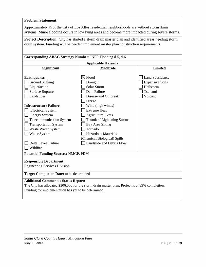
Santa Clara County Hazard Mitigation Plan May 11, 2012 P a g e | 13-50
Problem Statement:
Approximately ½ of the City of Los Altos residential neighborhoods are without storm drain systems. Minor flooding occurs in low lying areas and become more impacted during severe storms.
Project Description: City has started a storm drain master plan and identified areas needing storm drain system. Funding will be needed implement master plan construction requirements.
Corresponding ABAG Strategy Number: INFR Flooding d-5, d-6
Applicable Hazards Significant
Earthquakes
Ground Shaking Liquefaction Surface Rupture Landslides
Infrastructure Failure
Electrical System Energy System Telecommunication System Transportation System Waste Water System Water System
Delta Levee Failure Wildfire
Moderate
Flood Drought Solar Storm Dam Failure Disease and Outbreak Freeze Wind (high winds) Extreme Heat Agricultural Pests Thunder / Lightening Storms Bay Area Silting Tornado Hazardous Materials
(Chemical/Biological) Spills Landslide and Debris Flow
Limited
Land Subsidence Expansive Soils Hailstorm Tsunami Volcano
Potential Funding Sources: HMGP, PDM
Responsible Department: Engineering Services Division
Target Completion Date: to be determined
Additional Comments / Status Report: The City has allocated $306,000 for the storm drain master plan. Project is at 85% completion. Funding for implementation has yet to be determined.

Santa Clara County Hazard Mitigation Plan May 11, 2012 P a g e | 13-51
Problem Statement: The City of Los Altos is located in a highly active seismic region. Specifically, Seismic Design Category “D” and “E”, these categories are considered the most dangerous areas of potential ground shaking (earthquakes). Commencing January 2011, in order to mitigate seismic hazards, the City of Los Altos shall implement the following four areas including but not limited to; health and safety of the general public, loss of life, fire and structural damage to buildings. Project Description: The City of Los Altos requires State Architect approved Earthquake Actuated Gas Shut off Valves on all new, replaced, repaired, and relocated gas meters. 2) Los Altos requires more restrictive code regulations for lateral and uplift braced wall designs than the newly adopted 2010 California Building Code. 3) The City requires new commercial and residential buildings including additions over 50% to existing floor areas to be outfitted with fire suppressions systems. 4) Pre-approved engineered seismic plans are available at no cost to the general public to facilitate existing wood framed structures being earthquake retrofitted without the cost of hiring licensed engineers. Additional grant funding is needed to retrofit existing buildings with approved Earth Quake Actuated Gas Valves. Corresponding ABAG Strategy Number:
Applicable Hazards Significant Earthquakes X Ground Shaking X Liquefaction X Surface Rupture
Landslides Infrastructure Failure
Electrical System Energy System Telecommunication System Transportation System Waste Water System Water System
Delta Levee Failure Wildfire
Moderate
Flood Drought Solar Storm Dam Failure Disease and Outbreak Freeze Wind (high winds) Extreme Heat Agricultural Pests Thunder / Lightening Storms Bay Area Silting Tornado Hazardous Materials
(Chemical/Biological) Spills Landslide and Debris Flow
Limited
Land Subsidence Expansive Soils Hailstorm Tsunami Volcano
Potential Funding Sources: HMGP, PDM Responsible Department: Building, Engineering and Planning Divisions Target Completion Date: to be determined
Additional Comments / Status Report: The City of Los Altos incorporates approximately 11,000 individual parcels. The City of Los Altos does not have the funding to pursue retrofitting existing buildings with Earthquake Actuated Gas Valves.

Santa Clara County Hazard Mitigation Plan May 11, 2012 P a g e | 13-52
Problem Statement: While critical city - owned structures have been identified, there has not been a seismic assessment of these structures including essential services facilities. Project Description: Program to implement the seismic assessment study of city-owned structures and essential services facilities. The intent of the program is to prioritize recommendations from the study to address needs for seismic retrofit or other recommended actions for pre-disaster mitigation. Corresponding ABAG Strategy Number:
Applicable Hazards Significant Earthquakes
Ground Shaking Liquefaction Surface Rupture Landslides
Infrastructure Failure
Electrical System Energy System Telecommunication System Transportation System Waste Water System Water System
Delta Levee Failure Wildfire
Moderate
Flood Drought Solar Storm Dam Failure Disease and Outbreak Freeze Wind (high winds) Extreme Heat Agricultural Pests Thunder / Lightening Storms Bay Area Silting Tornado Hazardous Materials
(Chemical/Biological) Spills Landslide and Debris Flow
Limited
Land Subsidence Expansive Soils Hailstorm Tsunami Volcano
Potential Funding Sources: HMGP, PDM, No current funding sources exist. Need is recognized.
Responsible Department: Planning and Engineering Target Completion Date: Open
Additional Comments / Status Report: While no funding exists for this program, pre-disaster grant funding will be researched

Santa Clara County Hazard Mitigation Plan May 11, 2012 P a g e | 13-53
13.6 PLAN MAINTENANCE 13.6.1 Monitoring, evaluating, updating the plan The City of Los Altos Police Department will be responsible for ensuring that this annex is monitored on an on-going basis. However, the major disasters affecting Los Altos’ community, legal changes, notices from ABAG (as the lead agency in this process), notices from Santa Clara County (lead agency for the County-wide Annex), and other triggers will be used as well. Finally, the Annex will be a discussion/work item on the City’s Emergency Operations Center agenda each year, and department heads and other emergency preparedness staff, who serve in the City’s Emergency Operations Center, will focus on evaluating the Annex in light of technological and political changes that may occur during the year or other significant events. This group, in collaboration with Santa Clara County, will be responsible for determining if the plan should be updated. The City of Los Altos is committed to reviewing and updating this plan annex at least once every five years, as required by the Disaster Mitigation Act of 2000. The City’s Emergency Services Coordinator will contact ABAG four years after this plan is approved to ensure that ABAG plans to undertake the plan update process. If so, the City plans to participate in the multi-jurisdictional plan. If ABAG is unwilling or unable to act as the lead agency in the multi-jurisdictional effort, other agencies will be contacted, including the Santa Clara County Office of Emergency Services. The jurisdictions within Santa Clara County should continue to work together on updating this multi-jurisdictional plan. The public will continue to be involved whenever the plan is updated or as appropriate during the monitoring and evaluation process. Prior to adoption of updates, the City will provide the opportunity for the public to comment on the updates. A public notice will be published prior to the meeting to announce the comment period and meeting logistics. Moreover, the City will engage stakeholders in community emergency planning. 13.6.2 Point of Contact Comments or suggestions regarding this plan may be submitted at any time to Paul Arguelles, Sergeant. Contact information: [email protected], 650-947-2663

Santa Clara County Hazard Mitigation Plan May 11, 2012 P a g e | 13-54
13.7 CITY OF LOS ALTOS APPENDIX 13.7.1 Los Altos Attachment 1: Outreach Materials The City of Los Altos notified residents and businesses of the hazard mitigation planning process by distributing promotional announcements regarding the public opportunity to respond to the online survey. This Attachment includes those outreach materials.

Search
Weather Forecast | Weather Maps
Blach School Neighborhood Traffic Study Notice of Public Meeting and Report to Council
Notice Report Exhbits When: Tuesday, January 4 2011 at 6:00 PM Where: Los Altos High School - Eagle Theater @ 201 Almond Ave, Los Altos
Public Input Sought in Disaster Planning for Los Altos/Santa Clara County
The Santa Clara County Local Planning Team has identified 25 possible hazard threats, such as earthquakes, wild fires, and drought, within the county. Santa Clara County's Office of Emergency Services is collaborating with the incorporated cities to update the countywide local hazard mitigation plan. This plan outlines mechanisms for increasing our community's resiliency to natural hazard events.
Public feedback is critical to creating a safer community. Please take a few moments to complete the brief survey at: http://www.surveymonkey.com/s/2010SCCHMP.
The survey will be available online through Saturday, January 15, 2011. All residents or individuals employed within the boundaries of Santa Clara County and incorporated cities are encouraged to respond to the survey.
Hazard "mitigation" is defined as "sustained action taken to reduce or eliminate the long-term risk to human life and property from natural, human-caused, and technological hazards and their effects." - more
The updated local hazard mitigation plan will be an annex to the regional plan "Taming Natural Disasters: Multi-Jurisdictional Local Hazard Mitigation Plan for the San Francisco Bay Area". The current plan may be viewed at: http://quake.abag.ca.gov/mitigation/.
If you have any questions regarding the survey or opportunities to participate in the plan update, you may contact Corinne Bartshire at (510) 834-3326 or [email protected] .
Thank you for taking the time to help our community become more resilient.
Environmental Initial Study 400 Main Street Mixed Use Commercial Development
Public Review Period:
Quick Links
Council Meetings & Agendas
Committees and Commissions
Events Calendar
Police Services
Recreation
Newsletter
Municipal Code
Community Center Master Plan
Historical Financial Reports
Adopted City Budget
Salary Schedule by Postion
E-mail Notification Signup
Job Openings
Contact Us
Page 1 of 3City of Los Altos : Home
12/22/2010http://www.ci.los-altos.ca.us/


CITY OF LOS ALTOS
POLICE DEPARTMENT ONE NORTH SAN ANTONIO ROAD LOS ALTOS, CALIFORNIA 94022
PHONE (650) 947-2770 FAX (650) 947-2704
Santa Clara County / Los Altos LHMP
**PRESS RELEASE**
Announcing the release of the Review Draft for the Santa Clara County Local Hazard Mitigation Plan and the City of Los Altos Annex
Is your home or office building susceptible to damage from earthquakes, wildfires, floods, or utility service interruption? Do you want to help increase the likelihood that you can recover from disasters and prevent future damage from these and other natural hazards? Public review and comment is being solicited for the Review Draft of the Santa Clara County Local Hazard Mitigation Plan 2011 Update. This plan is currently under review by the California Emergency Management Agency (Cal EMA) and the Federal Emergency Management Agency (FEMA) to ensure compliance with the Federal Disaster Mitigation Act of 2000 allowing the County and participating cities to maintain eligibility to receive federal mitigation grant funding. The City of Los Altos has participated in this planning process and developed an annex to this plan detailing the City’s specific hazard risks and approaches to increase resiliency. PDF versions for the Santa Clara County LHMP and the Los Altos Annex draft may be reviewed or downloaded from http://www.sccgov.org/portal/site/oes/ by clicking on the LHMP link in the left column. With a grant from the Federal Emergency Management Agency (FEMA), the Santa Clara County Office of Emergency Services has coordinated with the incorporated cities to update the county’s Hazard Mitigation Plan. The planning process has involved thirteen incorporated cities, the Santa Clara Valley Water District, and major employers in Silicon Valley. The 2011 updated local hazard mitigation plan is an annex to the regional plan titled "Taming Natural Disasters: Multi-Jurisdictional Local Hazard Mitigation Plan for the San Francisco Bay Area” which may be viewed at: http://quake.abag.ca.gov/mitigation/. The Santa Clara County Local Hazard Mitigation Plan 2011 Update is being coordinated by the Santa Clara County Office of Emergency Services. If you have any questions or wish to comment on the Santa Clara County LHMP or Los Altos annex, please contact the County’s consultant: Corinne Bartshire at [email protected] or 415.295.7116.

1
Bartshire, Corinne
From: Matt Hartley [[email protected]]Sent: Thursday, April 21, 2011 4:32 PMTo: [email protected]; [email protected]; [email protected];
[email protected]; [email protected]; [email protected]; [email protected]
Cc: Bartshire, CorinneSubject: email distributionAttachments: Hazard Mitigation Email final PDF 4-19-2011.pdf; Draft hazard mitigation email
4-19-2011.doc
Community members, You have expressed an interest in receiving email information regarding the updating of the Los Altos Hazard Mitigation Plan and the County of Santa Clara Plan. Attached are a PDF version and a Microsoft Word version that will allow you to link to the new updates and drafts that have been sent to the California Emergency Management Agency and the Federal Emergency Management Agency. Should you have any questions or comments, you may respond via the attached links. Thank you, Matthew Hartley, Sergeant Los Altos Police Department 1. North San Antonio Road 650-947-2801

Search
Weather Forecast | Weather Maps
NEW! City of Los Altos Local Hazard Mitigation Plan 2011 Update Available for Public Review and Comment The City of Los Altos has participated with Santa Clara County in updating its Local Hazard Mitigation Plan. This plan is an annex to the Association of Bay Area Governments (ABAG) Regional Hazard Mitigation Plan. PDF versions for the Los Altos annex and the Santa Clara County LHMP may be reviewed or downloaded from the following link: www.sccgov.org If you have any questions or wish to comment on either the Santa Clara County LHMP or the City of Los Altos annex, please contact the County's consultant: Corinne Bartshire at 415-295-7116 or [email protected]. Public comments received prior to May 31, 2011 will be reviewed and integrated into the final plan for adoption, as appropriate. Comments submitted after that date will be recorded for future updates to the plan.
With a grant from the Federal Emergency Management Agency (FEMA), the Santa Clara County Office of Emergency Services has coordinated with the incorporated cities to develop this update. The planning process has involved thirteen incorporated cities, the Santa Clara Valley Water District, and major employers in Silicon Valley. The 2011 updated local hazard mitigation plan is an annex to the regional plan titled "Taming Natural Disasters: Multi-Jurisdictional Local Hazard Mitigation Plan for the San Francisco Bay Area" which may be viewed at: http://quake.abag.ca.gov/
Los Altos Police
Police Home
Inside LAPD
FAQ's
Organization
Applications and Forms
Emergency Preparedness
Los Altos Muni Code
Contact Information
Police Fee Schedule
Page 1 of 1City of Los Altos : Local Hazard Mitigation Plan 2011
4/22/2011http://www.ci.los-altos.ca.us/police/LHMP2011.html

Santa Clara County Hazard Mitigation Plan May 11, 2012 P a g e | 13-56
13.7.2 Los Altos Attachment 2: Los Altos Strategies 2010 The City of Los Altos participated in ABAG’s revision of the regional strategies for development of this annex. Appendix G of Taming Natural Hazards presents a summary list of mitigation strategies with regional priorities and the hazards mitigated. The City ranked those strategies in a spreadsheet provided by ABAG. This is a summary of those rankings.

Mitigation Strategies Identified for Los Altos
http://www.abag.ca.gov/bayarea/eqmaps/mitigation/strategy.html 1
JURISDICTION: Los Altos Strategy Priority Responsible Agency or Department Comments ECON-a-1 Existing Community Devlopment Dept ECON-a-2 n/a ECON-b-1 Existing ECON-b-2 Existing ECON-b-3 n/a ECON-b-4 Existing Underfunded Building Division Surveys Building Dept ECON-b-5 NYC ECON-b-6 n/a ECON-b-7 n/a ECON-b-8 n/a ECON-b-9 Existing Engineering / Planning / If plans
submitted
ECON-c-1 Existing City has no unreinforced Masonry
ECON-c-2 n/a ECON-c-3 Existing Underfunded ECON-c-4 Existing ECON-d-1 Existing Underfunded ECON-d-2 Existing ECON-d-3 n/a ECON-e-1 Existing Santa Clara County Fire / Los Altos
Public Works
ECON-e-2 NYC ECON-e-3 NYC ECON-e-4 Existing Title 12 LAMC ECON-e-5 Existing BUILDING DEPT 2007 CBC ECON-e-6 Existing Underfunded Central Fire Minimal Exposure ECON-e-7 Existing Underfunded Central Fire ECON-e-8 NYC Central Fire No current funding ECON-e-9 n/a City does not have high-rise
or high occupancy buildings of this nature
ECON-e-10 Existing Los Altos Central Fire ECON-e-11 NYC ECON-e-12 Existing Public Works Santa Clara County Water
District
ECON-e-13 n/a ECON-f-1 Existing Los Altos Community Development ECON-f-2 Existing LOS ALTOS PLANNING DEPT LAMC CODE TITLE 12 ECON-f-3 Existing LOS ALTOS PLANNING DEPT ECON-f-4 Existing City of Los Altos PUBLIC WORKS ECON-f-5 Existing CIty of Los Altos PUBLIC WORKS / City
website

Mitigation Strategies Identified for Los Altos
http://www.abag.ca.gov/bayarea/eqmaps/mitigation/strategy.html 2
ECON-f-6 Existing City of Los Altos Planning Dept LAMC CODE TITLE 12 ECON-f-7 NYC ECON-f-8 NYC ECON-f-9 Existing Same as regional approach ECON-g-1 Existing City of Los Altos Building and Planning
Departments Standard Operating Procedure
ECON-g-2 Existing Underfunded City of Los Altos Building and Planning Departments
SOP
ECON-h-1 Existing City of Los Altos Building and Planning Departments
2007 CBC
ECON-h-2 Existing ECON-h-3 Existing Underfunded Santa Clara County Fire Department /
Community Development CDD
ECON-i-1 Existing Underfunded Los Altos Building Department / Office of Emergency Services
SAP Program
ECON-i-2 NYC ECON-i-3 Existing Underfunded ECON-i-4 Existing Underfunded ECON-i-5 Under Study Community Development Dept ECON-i-6 n/a ECON-j-1 Existing City of Los Altos Website ECON-j-2 Existing Underfunded Los Altos Police Department / City of Los
Altos Website
ECON-j-3 NYC ECON-j-4 n/a ECON-j-5 n/a NO CERT PROGRAM ECON-j-6 n/a ECON-j-7 Existing City of Los Altos Website ECON-j-8 NYC ECON-j-9 n/a ECON-j-10 n/a ECON-j-11 n/a ECON-j-12 n/a ECON-j-13 Existing City of Los Altos Website EDUC-a-1 n/a Los Altos/ Mountain View School
Districts The City is a separate entity from the school districts.
EDUC-a-2 Existing Underfunded Los Altos Schools have been recently remodeled
EDUC-a-3 n/a The City is a separate entity from the school districts.
EDUC-a-4 n/a N/A EDUC-a-5 n/a EDUC-a-6 n/a EDUC-b-1 n/a EDUC-b-2 n/a EDUC-b-3 n/a

Mitigation Strategies Identified for Los Altos
http://www.abag.ca.gov/bayarea/eqmaps/mitigation/strategy.html 3
EDUC-c-1 n/a EDUC-c-2 n/a Santa Clara County Fire Department EDUC-c-3 n/a No Cert Program locally EDUC-c-4 n/a EDUC-c-5 n/a EDUC-c-6 n/a EDUC-c-7 n/a EDUC-d-1 n/a City maintains informational website for
residents / school children living within city boundaries.
EDUC-d-2 n/a ENVI-a-1 Existing Community Development Dept General Plan ENVI-a-2 Existing Community Development Dept / Police
Dept. / Santa Clara County Fire
ENVI-a-3 Existing Community Development Department State Code / General Plan ENVI-a-4 Under Study Santa Clara Calley Water District ENVI-a-5 Existing Santa Clara Calley Water District ENVI-a-6 Existing Santa Clara Valley Urban
Run-off Pollution Prevention Program (SCVURPPP)
ENVI-a-7 Existing Public Works Community Development Dept
Santa Clara Valley Urban Run-off Pollution Prevention Program (SCVURPPP)
ENVI-a-8 Existing Chatper 12.60 LAMC ENVI-a-9 Existing Community Development Dept / Santa
Clara County Fire
ENVI-a-10 Existing Santa Clara County Household Hazardous waste/ City of Los Altos
Santa Clara Valley Urban Run-off Pollution Prevention Program (SCVURPPP)
ENVI-a-11 Existing ENVI-a-12 Existing Underfunded Santa Clara Valley Water District/ City of
Los Altos Chapter 11.02 LAMC
ENVI-a-13 NYC/blank Santa Clara Valley Water District/ City of Los Altos
General Plan
ENVI-b-1 Existing City of Los Altos Planning Dept. / City Administration
ENVI-b-2 Existing Underfunded City of Los Altos ICLEI Report Risk Mgr. ENVI-b-3 Existing Underfunded Community Development CDD Downtown Urban Design
plan ENVI-b-4 Existing Underfunded City of Los Altos Bicycle / Ped plan
Traffic Commission General Plan
ENVI-b-5 NYC ENVI-b-6 Existing Underfunded Community Development CDD Ch. 12.66 LAMC Gen Pln ENVI-b-7 Existing Underfunded Los Altos Finance Dept ENVI-b-8 NYC/blank Los Altos Building Dept ENVI-b-9 Existing Underfunded Standard Operation Proc ENVI-b-10 Existing Underfunded City of Palo Alto

Mitigation Strategies Identified for Los Altos
http://www.abag.ca.gov/bayarea/eqmaps/mitigation/strategy.html 4
ENVI-b-11 NYC/blank City of Los Altos General Plan ENVI-b-12 Existing Underfunded City of Los Altos Planning Dept. ENVI-b-13 NYC/blank City of Los Altos Administration City website / News letter ENVI-c-1 n/a ENVI-c-2 n/a ENVI-c-3 n/a GOVT-a-1 Existing Underfunded City Manager's Office / Building /
Planning
GOVT-a-2 Existing Underfunded GOVT-a-3 Existing City Administration / Police Department/
Municipal Services /
GOVT-a-4 Existing Underfunded Information Technology/ Emergency Prep/ Administration
GOVT-a-5 Existing GOVT-a-6 n/a GOVT-a-7 n/a GOVT-a-8 n/a GOVT-a-9 Existing Building and Planning Community
Development
GOVT-a-10 Existing City of Los Altos Building and Planning Department
GOVT-a-11 Existing City of Los Altos Building and Planning Department
GOVT-a-12 n/a GOVT-a-13 NYC/blank GOVT-b-1 Existing Underfunded GOVT-b-2 Existing Los Altos Police Department / City
Administration
GOVT-b-3 Existing Underfunded Information Technology Division & Emergency Preparedness Coordinator
GOVT-b-4 Existing Underfunded Emergency Operations Plan / EOC plan GOVT-b-5 NYC/blank GOVT-c-1 Existing Santa Clara County Emergency Services GOVT-c-2 n/a City no longer maintains GOVT-c-3 Existing Los Altos General Plan GOVT-c-4 Existing GOVT-c-5 Existing Underfunded PPE Equipment purchased/ under
EPREP Grant/ Santa Clara County OESEMPG Grant assisted
GOVT-c-6 Existing Underfunded Los Altos Information Technology Dept / Los Altos Police Department Services Manager / County Wide / State wide prep
GOVT-c-7 Existing Underfunded GOVT-c-8 n/a GOVT-c-9 Existing Completed EOC center 2009

Mitigation Strategies Identified for Los Altos
http://www.abag.ca.gov/bayarea/eqmaps/mitigation/strategy.html 5
GOVT-c-10 Existing Underfunded EMA / Santa Clara County / Los Altos Police Department/ Santa Clara County Fire Department
GOVT-c-11 Existing Santa Clara County Fire Department / Los Altos Police Department
GOVT-c-12 Existing GOVT-c-13 Existing Underfunded Los Altos Police Department New Phone System call
back (Alert SCC) GOVT-c-14 Existing Underfunded Los Altos Police Department GOVT-c-15 NYC GOVT-c-16 Existing GOVT-c-17 Existing GOVT-c-18 Existing Underfunded County Fire GOVT-c-19 NYC GOVT-c-20 n/a GOVT-c-21 n/a Not below a dam GOVT-c-22 n/a GOVT-c-23 n/a GOVT-c-24 Existing Underfunded Los Altos Police Department GOVT-c-25 NYC/blank GOVT-d-1 Existing GOVT-d-2 Very High GOVT-d-3 Existing GOVT-d-4 Existing GOVT-d-5 Existing Underfunded Fire Protection District / Santa Clara
County Fire Department
GOVT-d-6 Existing Santa Clara County Fire Department GOVT-d-7 Existing Los Altos Building Department / Planning
Department
GOVT-d-8 Existing Underfunded Los Altos Administration GOVT-d-9 n/a GOVT-d-10 NYC/blank GOVT-e-1 Existing Underfunded ABAG GOVT-e-2 NYC/blank HEAL-a-1 Existing Underfunded COMMUNITY DEVELOPEMNT
DEPARTMENT / CDD / PLANNING
HEAL-a-2 n/a Reference Public Health Department Los Altos does not maintain a hospital within the city.
HEAL-a-3 Existing Santa Clara County Public Health Dept. HEAL-a-4 Existing Santa Clara County Public Health Dept. HEAL-a-5 Existing Underfunded HEAL-a-6 Existing Underfunded Santa Clar County Public Health Dept HEAL-a-7 Existing Los Altos Police Department / Santa
Clara County Fire/ Santa Clara County EMA
City maintains resource information on city website. Other printed materials on site.

Mitigation Strategies Identified for Los Altos
http://www.abag.ca.gov/bayarea/eqmaps/mitigation/strategy.html 6
HEAL-b-1 High HEAL-b-2 High HEAL-b-3 High HEAL-c-1 Existing Los Altos Police Department/ Santa
Clara County Health Dept City has designated POD site locations identified and pre planned for Distribution
HEAL-c-2 Existing Santa Clara County OES/ Santa Clara County Public Health
HEAL-c-3 Existing Santa Clara County OES/ Santa Clara County Public Health
HEAL-c-4 Existing Santa Clara County Health Dept / Santa Clara County Fire Department
HEAL-c-5 Existing Santa Clara County Health Department HEAL-c-6 NYC/blank HSNG-a-1 Existing Community Development Dept CDD Chapter 1260 LAMC HSNG-a-2 Existing Underfunded Community Development Dept CDD General Plan LAMC CH.
12.44 HSNG-a-3 Existing Recreation Dept/ Police Dept/ HSNG-a-4 n/a HSNG-b-1 Existing Underfunded Community Development Dept / CDD Title 12 LAMC HSNG-b-2 Existing Community Development Dept / CDD Title 12 LAMC HSNG-b-3 Existing Community Development Dept / CDD Title 12 LAMC HSNG-b-4 Existing Community Development Dept / CDD Title 12 LAMC HSNG-b-5 Existing Community Development Dept / CDD General Plan HSNG-b-6 Moderate Community Development Dept / CDD Informational HSNG-b-7 n/a HSNG-b-8 n/a HSNG-b-9 Existing Underfunded The City is in agreement
with this strategy but does not have a role in the implementation
HSNG-c-1 Existing Community Development Dept CDD HSNG-c-2 Existing Community Development Dept CDD Title 12 LAMC HSNG-c-3 n/a HSNG-c-4 Existing Underfunded Communit Development CDD Building Official Surveys HSNG-c-5 n/a HSNG-c-6 n/a HSNG-c-7 n/a HSNG-c-8 n/a HSNG-c-9 Under Study Community Development Dept HSNG-d-1 Existing Community Develoment Dept Building Official Surveys HSNG-d-2 n/a HSNG-d-3 NYC Community Develoment Dept HSNG-d-4 NYC Community Develoment Dept HSNG-e-1 n/a No Mobile homes within city
boundaries

Mitigation Strategies Identified for Los Altos
http://www.abag.ca.gov/bayarea/eqmaps/mitigation/strategy.html 7
HSNG-e-2 n/a This category does not existHSNG-e-3 Existing Community Development CDD Los Altos
Building Dept. General Plan / 2007 Building codes
HSNG-e-4 Existing Underfunded General Plan HSNG-f-1 Existing Community Development CDD Title 12 LAMC/ 2007
Building code HSNG-f-2 Existing Community Development CDD HSNG-g-1 Existing Santa Clara County Fire Dept General Plan HSNG-g-2 n/a HSNG-g-3 Existing HSNG-g-4 n/a HSNG-g-5 n/a Community Development Dept CDD HSNG-g-6 Existing Community Development Dept CDD /
Santa Clara County Fire Dept 2007 Building / Fire Codes
HSNG-g-7 Existing Community Development / CDD / Santa Clara County Fired Dept
HSNG-g-8 Existing Underfunded Santa Clara County Fire Department / Santa Clara Valley Water District / Cal Water
HSNG-g-9 Existing Underfunded Santa Clara County Fire Department HSNG-g-10 Existing Underfunded Santa Clara County Fire Department HSNG-g-11 Existing Underfunded Santa Clara County Fire Department HSNG-g-12 n/a HSNG-g-13 Existing Community Development SCC Fire
Department
HSNG-g-14 Existing Community Development SCC Fire Department
HSNG-g-15 n/a Not Applicable HSNG-g-16 Existing Santa Clara County Fire Department HSNG-g-17 Existing Underfunded Santa Clara County Fire Department /
Santa Clara Valley Water District
HSNG-g-18 Existing Community Development Building Department / 2007 Building and Fire Code
HSNG-g-19 Moderate Community Development / Santa Clara County Fire Department / PG&E
HSNG-g-20 NYC/blank HSNG-h-1 NYC/blank HSNG-h-2 Existing Communtiy Development Department
CDD 12.60 LAMC
HSNG-h-3 Existing Communtiy Development Department CDD
12.60 LAMC
HSNG-h-4 Existing Communtiy Development Department CDD
Chapter 10.16 LAMC NPDES Permit
HSNG-h-5 Existing Public Works / Engineering General Plan HSNG-h-6 Existing Police Department / Engineering / Public
Works

Mitigation Strategies Identified for Los Altos
http://www.abag.ca.gov/bayarea/eqmaps/mitigation/strategy.html 8
HSNG-h-7 Existing Communtiy Development Department CDD
12.60 LAMC
HSNG-h-8 Existing Communtiy Development Department CDD/Public Works
General Plan
HSNG-h-9 Existing Communtiy Development Department CDD
General Plan
HSNG-h-10 Moderate Communtiy Development Department CDD
Same as Regional priority
HSNG-i-1 NYC/blank HSNG-i-2 Existing Los Altos Planning Department / Public
Works
HSNG-j-1 NYC/blank HSNG-j-2 Existing Community Develoment Dept Same as regional priority HSNG-k-1 NYC/blank HSNG-k-2 Existing City website / Community Development HSNG-k-3 Existing Underfunded City website / Community Development/
Emergency Preparation guidelines Citizen Corps Council
HSNG-k-4 n/a HSNG-k-5 NYC HSNG-k-6 Existing County / Sate Emergency Prep City no longer maintains
CERT PROGRAM HSNG-k-7 n/a American Red Cross Citizen Corps HSNG-k-8 n/a HSNG-k-9 Existing Underfunded Crime Prevention Block Captains/ Los
Altos Police Department
HSNG-k-10 NYC HSNG-k-11 Existing Disaster Preparation / City Website /
Citizen Corps / Santa Clara County Fire
HSNG-k-12 Moderate Provision to HAM operators / Assist / Emergency Mgmt.
HSNG-k-13 Existing Los Altos Planning Dept City website referral HSNG-k-14 NYC HSNG-k-15 n/a HSNG-k-16 n/a City of Los Altos has no
shoreline properties INFR-a-1 Existing Underfunded Publice Works (MSC) Recognize / Not lead in
Strategy INFR-a-2 n/a Los Altos is not a Dam
owner INFR-a-3 Existing Police Dept / Municipal Service / City
Administration
INFR-a-4 Existing Underfunded City Administration / Municipal Services / Planning Dept
Underfunded
INFR-a-5 Existing County Transportation support

Mitigation Strategies Identified for Los Altos
http://www.abag.ca.gov/bayarea/eqmaps/mitigation/strategy.html 9
INFR-a-6 Existing Los Altos and Palo Altos RWCP Partners meet regularly re wast water issues
INFR-a-7 Existing City of Los Altos Planning Dept, Public Works Dept.
INFR-a-8 Existing Underfunded In Place City of Los Altos PD/ MSC to operate critical facilility needs
INFR-a-9 NYC INFR-a-10 Existing Underfunded Refurbished local pedestrian pathway
bridges bordering city
INFR-a-11 Existing Underfunded Critical backup generators in place Police and MSC
INFR-a-12 Under Study Los Altos Planning Department INFR-a-13 n/a Not a Dam Owner INFR-a-14 Existing Los Altos PD / EOC / Part of SCC EMA INFR-a-15 Existing Los Altos Police Department Santa Clara
County Fire Standard Operating procedures
INFR-a-16 Existing City Cooling Centers/ Police Department policy/Communications via County of Santa Clara City provides cooling centers
INFR-a-17 Existing MTC INFR-a-18 Existing Underfunded Santa Clara County office of Emergency
Services / Emergency Mgrs / Los Altos Police Department
INFR-a-19 Existing Los Altos Public Works / Cal Water / City of Palo Alto
INFR-a-20 Existing Underfunded Los Altos Public Works INFR-a-21 Existing In place at Los Altos PD and Municipal
Service Center 707 Fremont Ave. Los Altos / EOC backup
INFR-a-22 NYC/blank INFR-b-1 Existing Underfunded City of Los Altos does not have City
Transportation System
INFR-b-2 Existing INFR-b-3 Existing Underfunded INFR-b-4 Existing Underfunded Cal Water Retrofit water tanks. INFR-b-5 Existing Underfunded INFR-b-6 Existing Underfunded Not applicable in Los Altos INFR-b-7 Existing Standard Operating procedures INFR-b-8 Existing Standard Operating procedures INFR-b-9 Existing The city is in agreement but
does not have a lead in this project
INFR-b-10 NYC/blank INFR-c-1 Existing Underfunded SANTA CLARA COUNTY FIRE / CAL
WATER
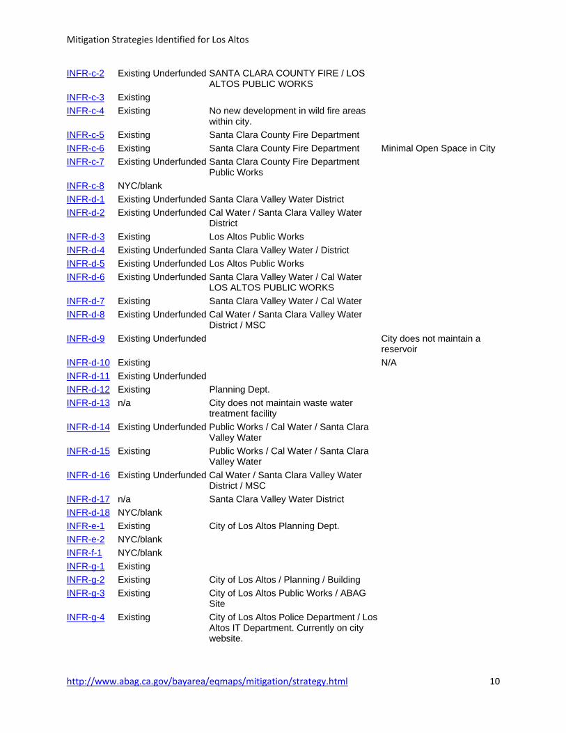
Mitigation Strategies Identified for Los Altos
http://www.abag.ca.gov/bayarea/eqmaps/mitigation/strategy.html 10
INFR-c-2 Existing Underfunded SANTA CLARA COUNTY FIRE / LOS ALTOS PUBLIC WORKS
INFR-c-3 Existing INFR-c-4 Existing No new development in wild fire areas
within city.
INFR-c-5 Existing Santa Clara County Fire Department INFR-c-6 Existing Santa Clara County Fire Department Minimal Open Space in City INFR-c-7 Existing Underfunded Santa Clara County Fire Department
Public Works
INFR-c-8 NYC/blank INFR-d-1 Existing Underfunded Santa Clara Valley Water District INFR-d-2 Existing Underfunded Cal Water / Santa Clara Valley Water
District
INFR-d-3 Existing Los Altos Public Works INFR-d-4 Existing Underfunded Santa Clara Valley Water / District INFR-d-5 Existing Underfunded Los Altos Public Works INFR-d-6 Existing Underfunded Santa Clara Valley Water / Cal Water
LOS ALTOS PUBLIC WORKS
INFR-d-7 Existing Santa Clara Valley Water / Cal Water INFR-d-8 Existing Underfunded Cal Water / Santa Clara Valley Water
District / MSC
INFR-d-9 Existing Underfunded City does not maintain a reservoir
INFR-d-10 Existing N/A INFR-d-11 Existing Underfunded INFR-d-12 Existing Planning Dept. INFR-d-13 n/a City does not maintain waste water
treatment facility
INFR-d-14 Existing Underfunded Public Works / Cal Water / Santa Clara Valley Water
INFR-d-15 Existing Public Works / Cal Water / Santa Clara Valley Water
INFR-d-16 Existing Underfunded Cal Water / Santa Clara Valley Water District / MSC
INFR-d-17 n/a Santa Clara Valley Water District INFR-d-18 NYC/blank INFR-e-1 Existing City of Los Altos Planning Dept. INFR-e-2 NYC/blank INFR-f-1 NYC/blank INFR-g-1 Existing INFR-g-2 Existing City of Los Altos / Planning / Building INFR-g-3 Existing City of Los Altos Public Works / ABAG
Site
INFR-g-4 Existing City of Los Altos Police Department / Los Altos IT Department. Currently on city website.

Mitigation Strategies Identified for Los Altos
http://www.abag.ca.gov/bayarea/eqmaps/mitigation/strategy.html 11
INFR-g-5 n/a CITY NO LONGER MAINTAINS CERT PROGRAM / CITIZEN CORPS PROGRAM
INFR-g-6 Existing City of Los Altos Police Department / Los Altos IT Department. Currently on city website.
INFR-g-7 NYC/blank LAND-a-1 Existing Building Division / Planning Division LAND-a-2 Existing Community Development General Plan LAND-a-3 n/a LAND-a-4 Under Study LAND-a-5 Under Study LAND-a-6 Existing Community Development LAND-a-7 Existing Community Development Dept LAND-a-8 Existing LAND-b-1 Existing Community Development / Santa Clara
County Fire Department
LAND-b-2 Existing Santa Clara County Fire Department LAND-c-1 Existing Community Development Department LAMC 12.60 General Plan LAND-c-2 Existing Los Altos Public Works Santa Clara
Valley Water Dist LAMC 12.60 General Plan
LAND-c-3 Existing Los Altos Public Works / Community Development Dept
Santa Clara Valley Water
LAND-c-4 Existing Community Development Department 12.60 LAMC LAND-c-5 Very High Community Development Department Santa Clara Valley Water LAND-c-6 Very High Not taking lead LAND-d-1 Existing Community Development Department General Plan LAND-d-2 Existing Community Development Department General Plan LAND-d-3 Existing Community Development Department General Plan LAND-d-4 Existing Community Development Department General Plan LAND-d-5 Existing Community Development Department General Plan LAND-e-1 Existing Community Development Department General Plan LAND-e-2 Existing Community Development Department General Plan LAND-f-1 Existing City Administration General Plan LAND-f-2 Existing Underfunded Community Development Department LAND-f-3 Existing Underfunded Community Development Department LAND-f-4 n/a LAND-f-5 n/a LAND-g-1 n/a Source:
Association of Bay Area Governments, 2009.

Santa Clara County Hazard Mitigation Plan May 11, 2012 P a g e | 13-58
13.7.3 Los Altos Attachment 3: Los Altos Exposure Analysis This list includes all information on Los Altos’ critical facilities and identifies which of the City’s critical facilities are located in the mapped hazard areas. It should be noted that the critical facilities used in Section 13.4.2.2 have been updated since ABAG’s conducted exposure analysis. There may be some discrepancies with the identified critical facilities in that section and those in Los Altos Attachment 3: Exposure Analysis.

City of Los Altos Exposure Analysis
ID Critical Facility Address Type Occupancy Own/Lease Structure Type
33 restrooms 707 fremont avenue N/A own Light wood-frame building less <= to 5,000 SQFT
34 restrooms 707 fremont avenue N/A own Light wood-frame building less <= to 5,000 SQFT
35 portable sch-oak 1501 oak avenue 45 own MH
36 city hall 1 n. san antonio rd 30 own S 1/2
37 library 1 n san antonio road 20 own Reinforced masonry with flexible floor and roof
1 Woodland Library 1975 Grant Road N/A N/A N/A
2 restroom portland & miramonte N/A own Light wood-frame building less <= to 5,000 SQFT
3 classroom 1575 holt avenue N/A own Light wood-frame building less <= to 5,000 SQFT
4 multi-purp@grnt pk 1575 holt avenue N/A own Light wood-frame building less <= to 5,000 SQFT
5 restroom/park fremont avenue & grant N/A own Light wood-frame building less <= to 5,000 SQFT
6 shop & shed 707 fremont avenue 2 own S3
7 garage 707 fremont avenue 1 own Reinforced masonry with flexible floor and roof
8 corp yard 707 fremont avenue N/A own Light wood-frame building less <= to 5,000 SQFT
9 office/storage 707 fremont avenue 15 own Light wood-frame building less <= to 5,000 SQFT
10 bike bridge fremont av & permanente crk N/A own Bridge
11 police dept 1 n. san antonio rd 46 own Wood-frame building > 5,000 SQFT
12 youth center 1 n. san antonio rd 3 own Wood-frame building > 5,000 SQFT
13 history house 51 s san antonio road N/A own Light wood-frame building less <= to 5,000 SQFT
14 hillview hall cc 97 hillview ave N/A own Light wood-frame building less <= to 5,000 SQFT
15 multi-purpose 97 hillview ave N/A own Light wood-frame building less <= to 5,000 SQFT
16 administ bldg 97 hillview ave 12 own Light wood-frame building less <= to 5,000 SQFT
17 seni0r citizen 97 hillview ave 20 own Light wood-frame building less <= to 5,000 SQFT
18 classrooms 16-18 97 hillview ave N/A own Light wood-frame building less <= to 5,000 SQFT
19 hillview home 183 hillview 5 own Light wood-frame building less <= to 5,000 SQFT
20 stg garage 1 n. san antonio rd N/A own Light wood-frame building less <= to 5,000 SQFT
21 san antonio club 647 s. san antonio 20 own Light wood-frame building less <= to 5,000 SQFT
22 museum 1 n. san antonio rd 5 own Wood-frame building > 5,000 SQFT
23 theatre - lact 97 hillview ave N/A own S3
24 hal brady 97 hillview ave N/A own Light wood-frame building less <= to 5,000 SQFT
25 children center 97 hillview ave 45 own Light wood-frame building less <= to 5,000 SQFT
26 classrooms 7,8,9 97 hillview ave N/A own Light wood-frame building less <= to 5,000 SQFT
27 classrooms 13-15 97 hillview ave N/A own Light wood-frame building less <= to 5,000 SQFT
28 bike bridge hetch hetchy & adobe creek N/A N/A Bridge
29 garden bldg. 400 university ave 2 own Light wood-frame building less <= to 5,000 SQFT
30 shoop prk wc 400 university ave N/A own Light wood-frame building less <= to 5,000 SQFT
31 nature center 482 university ave 5 own Light wood-frame building less <= to 5,000 SQFT
32 residence 482 university ave 4 own Light wood-frame building less <= to 5,000 SQFT
ID Critical Facility Structure Information Irregularities-Plan View Irregularities Vertical
Structural
Assessment Retrofit
33 restrooms N/A regular hgh windows N/A N/A
34 restrooms N/A half octagon N/A N/A N/A
35 portable sch-oak N/A regular braced N/A N/A
36 city hall N/A many lg openings also wd N/A Additn in 85 include evaluation
37 library N/A L shaped N/A N/A Additn in 85 include renov+evaluati
1 Woodland Library N/A N/A N/A N/A N/A
Page 1

City of Los Altos Exposure Analysis
ID Critical Facility Structure Information Irregularities-Plan View Irregularities Vertical
Structural
Assessment Retrofit
2 restroom N/A slight T N/A N/A N/A
3 classroom N/A regular hgh windows N/A N/A
4 multi-purp@grnt pk Was part of Grant Park School high windows N/A N/A N/A
5 restroom/park N/A slight T N/A N/A N/A
6 shop & shed N/A regular large openings N/A N/A
7 garage N/A wide T lg openings, addition N/A N/A
8 corp yard N/A long rectangle large openings N/A N/A
9 office/storage N/A regular N/A N/A N/A
10 bike bridge N/A bike bridge N/A N/A N/A
11 police dept N/A complex L also wd N/A N/A
12 youth center N/A complex L also wd N/A N/A
13 history house N/A farm house bolts, crip.wall, plywd N/A N/A
14 hillview hall cc Was school slight L N/A N/A N/A
15 multi-purpose N/A regular hgh windows N/A N/A
16 administ bldg N/A regular large openings N/A N/A
17 seni0r citizen N/A regular hgh windows N/A N/A
18 classrooms 16-18 N/A regular hgh windows N/A N/A
19 hillview home N/A part 2 story with porch N/A N/A
20 stg garage N/A lg openings needs bolts N/A nonflam strge
21 san antonio club N/A L shaped bolts, plywd N/A N/A
22 museum N/A no data N/A N/A N/A
23 theatre - lact N/A large openings N/A N/A N/A
24 hal brady N/A regular large openings N/A N/A
25 children center N/A regular large openings N/A N/A
26 classrooms 7,8,9 N/A regular hgh windows N/A N/A
27 classrooms 13-15 N/A regular hgh windows N/A N/A
28 bike bridge N/A N/A N/A N/A N/A
29 garden bldg. Bolts ok and no cripple wall above grnd basemt N/A N/A N/A
30 shoop prk wc N/A regular N/A N/A N/A
31 nature center N/A complex U tile roof N/A N/A
32 residence N/A L shaped cripple wall N/A N/A
ID Critical Facility Anchored Equipment Alternate Power Sprinklers Roof Material Year Built
33 restrooms no no no Wood Shake N/A
34 restrooms no no no Wood Shake N/A
35 portable sch-oak no no no asphalt N/A
36 city hall no yes yes Wood Shake N/A
37 library no no yes Wood Shake N/A
1 Woodland Library N/A N/A N/A N/A N/A
2 restroom no no no Wood Shake N/A
3 classroom no no no asphalt N/A
4 multi-purp@grnt pk no no no asphalt N/A
5 restroom/park no no no tar N/A
6 shop & shed no no yes metal N/A
7 garage no no no Wood Shake N/A
8 corp yard no no no N/A N/A
9 office/storage no no no Wood Shake N/A
Page 2

City of Los Altos Exposure Analysis
ID Critical Facility Anchored Equipment Alternate Power Sprinklers Roof Material Year Built
10 bike bridge no no no N/A N/A
11 police dept no yes yes Wood Shake N/A
12 youth center no no no Wood Shake N/A
13 history house no no no Wood Shake N/A
14 hillview hall cc no no no asphalt N/A
15 multi-purpose no no no asphalt N/A
16 administ bldg no yes no asphalt N/A
17 seni0r citizen no no no asphalt N/A
18 classrooms 16-18 no no no asphalt N/A
19 hillview home no no no Wood Shake N/A
20 stg garage no no no Wood Shake N/A
21 san antonio club no no yes Wood Shake N/A
22 museum no no yes Wood Shake N/A
23 theatre - lact no no no asphalt N/A
24 hal brady no no no asphalt N/A
25 children center no no no asphalt N/A
26 classrooms 7,8,9 no no no asphalt N/A
27 classrooms 13-15 no no no asphalt N/A
28 bike bridge N/A N/A N/A N/A N/A
29 garden bldg. no no yes Wood Shake N/A
30 shoop prk wc no no no N/A N/A
31 nature center no no no tile N/A
32 residence no no no Wood Shake N/A
ID Critical Facility Stories Capacity Bldg Insured Value
Contents Insured
Value
33 restrooms 1 160 36946 0
34 restrooms 1 132 29344 0
35 portable sch-oak 1 1000 97638 0
36 city hall 1 10260 1258765 525358
37 library 1 28420 2484542 0
1 Woodland Library N/A N/A N/A N/A
2 restroom 1 341 34409 0
3 classroom 1 4806 536071 0
4 multi-purp@grnt pk 1 0 625758 0
5 restroom/park 1 376 40922 0
6 shop & shed 1 10200 466832 0
7 garage 1 3234 262671 0
8 corp yard 1 1600 74754 0
9 office/storage 1 6000 599545 0
10 bike bridge 0 0 67000 0
11 police dept 1 9935 1639488 949619
12 youth center 1 5940 491954 12246
13 history house 2 2247 178530 29870
14 hillview hall cc 1 4334 502527 191610
15 multi-purpose 1 3709 349051 0
16 administ bldg 1 1173 138231 0
17 seni0r citizen 1 3200 330527 0
Page 3

City of Los Altos Exposure Analysis
ID Critical Facility Stories Capacity Bldg Insured Value
Contents Insured
Value
18 classrooms 16-18 1 3424 345555 0
19 hillview home 1 1132 162062 0
20 stg garage 1 1357 80065 0
21 san antonio club 1 1668 151809 4064
22 museum 1 28420 2484542 0
23 theatre - lact 1 3920 255966 0
24 hal brady 1 3072 347941 0
25 children center 1 3424 359227 0
26 classrooms 7,8,9 1 3649 351546 0
27 classrooms 13-15 1 3200 334479 0
28 bike bridge 0 0 0 0
29 garden bldg. 1 5692 752430 0
30 shoop prk wc 1 312 52090 0
31 nature center 1 3077 387677 0
32 residence 1 1082 129760 0
ID Critical Facility # of Dams
Wildland-Urban Interface (WUI)
Fire Threat Wildfire Threat FEMA Flood Zone Tsunami
33 restrooms 0 Fire-Threatened Area Moderate Outside Floodplain Not Affected
34 restrooms 0 Fire-Threatened Area Moderate Outside Floodplain Not Affected
35 portable sch-oak 0 Fire-Threatened Area Moderate 500 Year Flood Not Affected
36 city hall 0 Outside WUI hazard area Moderate 100 Year Flood Not Affected
37 library 0 Outside WUI hazard area Moderate 100 Year Flood Not Affected
1 Woodland Library N/A N/A N/A N/A N/A
2 restroom 0 Outside WUI hazard area Moderate 100 Year Flood Not Affected
3 classroom 0 Fire-Threatened Area Moderate 500 Year Flood Not Affected
4 multi-purp@grnt pk 0 Fire-Threatened Area Moderate 500 Year Flood Not Affected
5 restroom/park 0 Outside WUI hazard area Moderate 500 Year Flood Not Affected
6 shop & shed 0 Fire-Threatened Area Moderate 500 Year Flood Not Affected
7 garage 0 Fire-Threatened Area Moderate 500 Year Flood Not Affected
8 corp yard 0 Fire-Threatened Area Moderate 500 Year Flood Not Affected
9 office/storage 0 Fire-Threatened Area Moderate 500 Year Flood Not Affected
10 bike bridge 0 Fire-Threatened Area Moderate 500 Year Flood Not Affected
11 police dept 0 Outside WUI hazard area Moderate 500 Year Flood Not Affected
12 youth center 0 Outside WUI hazard area Moderate 500 Year Flood Not Affected
13 history house 0 Outside WUI hazard area Moderate 500 Year Flood Not Affected
14 hillview hall cc 0 Outside WUI hazard area Moderate 500 Year Flood Not Affected
15 multi-purpose 0 Outside WUI hazard area Moderate 500 Year Flood Not Affected
16 administ bldg 0 Outside WUI hazard area Moderate 500 Year Flood Not Affected
17 seni0r citizen 0 Outside WUI hazard area Moderate 500 Year Flood Not Affected
18 classrooms 16-18 0 Outside WUI hazard area Moderate 500 Year Flood Not Affected
19 hillview home 0 Outside WUI hazard area Moderate 500 Year Flood Not Affected
20 stg garage 0 Outside WUI hazard area Moderate 500 Year Flood Not Affected
21 san antonio club 0 Outside WUI hazard area Moderate 500 Year Flood Not Affected
22 museum 0 Outside WUI hazard area Moderate 500 Year Flood Not Affected
23 theatre - lact 0 Outside WUI hazard area Moderate 500 Year Flood Not Affected
24 hal brady 0 Outside WUI hazard area Moderate 500 Year Flood Not Affected
Page 4

City of Los Altos Exposure Analysis
ID Critical Facility # of Dams
Wildland-Urban Interface (WUI)
Fire Threat Wildfire Threat FEMA Flood Zone Tsunami
25 children center 0 Outside WUI hazard area Moderate 500 Year Flood Not Affected
26 classrooms 7,8,9 0 Outside WUI hazard area Moderate 500 Year Flood Not Affected
27 classrooms 13-15 0 Outside WUI hazard area Moderate 500 Year Flood Not Affected
28 bike bridge 0 Fire-Threatened Area Moderate 100 Year Flood Not Affected
29 garden bldg. 0 Fire-Threatened Area Moderate 500 Year Flood Not Affected
30 shoop prk wc 0 Fire-Threatened Area Moderate 500 Year Flood Not Affected
31 nature center 0 Fire-Threatened Area Moderate 500 Year Flood Not Affected
32 residence 0 Fire-Threatened Area Moderate 500 Year Flood Not Affected
ID Critical Facility Existing Landslide Areas EQ-Induced Landslide EQ Shake Potential
Liquefaction
Susceptibility EQ-Induced Liquefaction
33 restrooms Few Landslides Mapping Planned 75 Very Low Mapping Planned
34 restrooms Few Landslides Mapping Planned 75 Very Low Mapping Planned
35 portable sch-oak Surficial Deposits Outside of CGS Landslide Zone 55 Moderate Outside of CGS Liquefaction Zone
36 city hall Surficial Deposits Mapping in Progress 85 Moderate Mapping in Progress
37 library Surficial Deposits Mapping in Progress 85 Moderate Mapping in Progress
1 Woodland Library N/A N/A N/A N/A N/A
2 restroom Surficial Deposits Outside of CGS Landslide Zone 65 Moderate Outside of CGS Liquefaction Zone
3 classroom Surficial Deposits Outside of CGS Landslide Zone 65 Moderate Outside of CGS Liquefaction Zone
4 multi-purp@grnt pk Surficial Deposits Outside of CGS Landslide Zone 65 Moderate Outside of CGS Liquefaction Zone
5 restroom/park Surficial Deposits Outside of CGS Landslide Zone 65 Low Outside of CGS Liquefaction Zone
6 shop & shed Surficial Deposits Outside of CGS Landslide Zone 65 Low Outside of CGS Liquefaction Zone
7 garage Surficial Deposits Outside of CGS Landslide Zone 65 Low Outside of CGS Liquefaction Zone
8 corp yard Surficial Deposits Outside of CGS Landslide Zone 65 Low Outside of CGS Liquefaction Zone
9 office/storage Surficial Deposits Outside of CGS Landslide Zone 65 Low Outside of CGS Liquefaction Zone
10 bike bridge Surficial Deposits Outside of CGS Landslide Zone 65 Low Outside of CGS Liquefaction Zone
11 police dept Surficial Deposits Outside of CGS Landslide Zone 65 Low Outside of CGS Liquefaction Zone
12 youth center Surficial Deposits Outside of CGS Landslide Zone 65 Low Outside of CGS Liquefaction Zone
13 history house Surficial Deposits Outside of CGS Landslide Zone 65 Low Outside of CGS Liquefaction Zone
14 hillview hall cc Surficial Deposits Outside of CGS Landslide Zone 65 Low Outside of CGS Liquefaction Zone
15 multi-purpose Surficial Deposits Outside of CGS Landslide Zone 65 Low Outside of CGS Liquefaction Zone
16 administ bldg Surficial Deposits Outside of CGS Landslide Zone 65 Low Outside of CGS Liquefaction Zone
17 seni0r citizen Surficial Deposits Outside of CGS Landslide Zone 65 Low Outside of CGS Liquefaction Zone
18 classrooms 16-18 Surficial Deposits Outside of CGS Landslide Zone 65 Low Outside of CGS Liquefaction Zone
19 hillview home Surficial Deposits Outside of CGS Landslide Zone 65 Low Outside of CGS Liquefaction Zone
20 stg garage Surficial Deposits Outside of CGS Landslide Zone 65 Low Outside of CGS Liquefaction Zone
21 san antonio club Surficial Deposits Outside of CGS Landslide Zone 65 Low Outside of CGS Liquefaction Zone
22 museum Surficial Deposits Outside of CGS Landslide Zone 65 Low Outside of CGS Liquefaction Zone
23 theatre - lact Surficial Deposits Outside of CGS Landslide Zone 65 Low Outside of CGS Liquefaction Zone
24 hal brady Surficial Deposits Outside of CGS Landslide Zone 65 Low Outside of CGS Liquefaction Zone
25 children center Surficial Deposits Outside of CGS Landslide Zone 65 Low Outside of CGS Liquefaction Zone
26 classrooms 7,8,9 Surficial Deposits Outside of CGS Landslide Zone 65 Low Outside of CGS Liquefaction Zone
27 classrooms 13-15 Surficial Deposits Outside of CGS Landslide Zone 65 Low Outside of CGS Liquefaction Zone
28 bike bridge Surficial Deposits Outside of CGS Landslide Zone 65 Very High Liquefaction Hazard Zone
29 garden bldg. Surficial Deposits Outside of CGS Landslide Zone 75 Low Outside of CGS Liquefaction Zone
30 shoop prk wc Surficial Deposits Outside of CGS Landslide Zone 75 Low Outside of CGS Liquefaction Zone
31 nature center Surficial Deposits Outside of CGS Landslide Zone 75 Low Outside of CGS Liquefaction Zone
Page 5

City of Los Altos Exposure Analysis
ID Critical Facility Sea Level Risk 16" Sea Level Rise 55"
32 residence Surficial Deposits Outside of CGS Landslide Zone 75 Low Outside of CGS Liquefaction Zone
33 restrooms Not Affected Not Affected
34 restrooms Not Affected Not Affected
35 portable sch-oak Not Affected Not Affected
ID Critical Facility Sea Level Risk 16" Sea Level Rise 55"
36 city hall Not Affected Not Affected
37 library Not Affected Not Affected
1 Woodland Library N/A N/A
2 restroom Not Affected Not Affected
3 classroom Not Affected Not Affected
4 multi-purp@grnt pk Not Affected Not Affected
5 restroom/park Not Affected Not Affected
6 shop & shed Not Affected Not Affected
7 garage Not Affected Not Affected
8 corp yard Not Affected Not Affected
9 office/storage Not Affected Not Affected
10 bike bridge Not Affected Not Affected
11 police dept Not Affected Not Affected
12 youth center Not Affected Not Affected
13 history house Not Affected Not Affected
14 hillview hall cc Not Affected Not Affected
15 multi-purpose Not Affected Not Affected
16 administ bldg Not Affected Not Affected
17 seni0r citizen Not Affected Not Affected
18 classrooms 16-18 Not Affected Not Affected
19 hillview home Not Affected Not Affected
20 stg garage Not Affected Not Affected
21 san antonio club Not Affected Not Affected
22 museum Not Affected Not Affected
23 theatre - lact Not Affected Not Affected
24 hal brady Not Affected Not Affected
25 children center Not Affected Not Affected
26 classrooms 7,8,9 Not Affected Not Affected
27 classrooms 13-15 Not Affected Not Affected
28 bike bridge Not Affected Not Affected
29 garden bldg. Not Affected Not Affected
30 shoop prk wc Not Affected Not Affected
31 nature center Not Affected Not Affected
32 residence Not Affected Not Affected
Page 6