© CEH 3. Semi-Natural Grasslands: Neutral, Calcareous and ... · Countryside Survey: Wales Results...
8
Countryside Survey: Wales Results from 2007 CHAPTER 3 • Semi-Natural Grasslands: Neutral, Calcareous and Acid Grassland Broad Habitats 26 Summary Area • Of the three Broad Habitats, Neutral Grassland covered the largest area in 2007 at 12% of the area of Wales with 60% of this being found in the lowland zone. Acid Grassland covered 10% of the land area of Wales in 2007 and Calcareous Grassland just 0.06%. • No significant change in any of the Broad Habitats was seen across Wales between 1998 and 2007. However, within the upland zone Neutral Grassland decreased and Acid Grassland increased significantly in area although the confidence intervals for the size of the changes were large. Vegetation condition • Few significant changes were detected between 1990, 1998 and 2007, and none were based on large effect sizes. Hence ecological impacts are likely to be minor. Soils • Soil pH increased in Neutral Grassland between 1978 and 2007 but not between 1998 and 2007. No change in pH occurred in Acid Grassland. • Carbon concentration did not change in either Broad Habitat. 3. Semi-Natural Grasslands: Neutral, Calcareous and Acid Grassland Broad Habitats Semi-natural grassland • © CEH
Transcript of © CEH 3. Semi-Natural Grasslands: Neutral, Calcareous and ... · Countryside Survey: Wales Results...

Countryside Survey: Wales Results from 2007 CHAPTER 3 • Semi-Natural Grasslands: Neutral, Calcareous and Acid Grassland Broad Habitats 26
Summary
Area
• Of the three Broad Habitats, Neutral Grassland covered the largest area in 2007 at 12% of the area of Wales with 60% of this being found in the lowland zone. Acid Grassland covered 10% of the land area of Wales in 2007 and Calcareous Grassland just 0.06%.
• No signifi cant change in any of the Broad Habitats was seen across Wales between 1998 and 2007. However, within the upland zone Neutral Grassland decreased and Acid Grassland increased signifi cantly in area although the confi dence intervals for the size of the changes were large.
Vegetation condition
• Few signifi cant changes were detected between 1990, 1998 and 2007, and none were based on large eff ect sizes. Hence ecological impacts are likely to be minor.
Soils
• Soil pH increased in Neutral Grassland between 1978 and 2007 but not between 1998 and 2007. No change in pH occurred in Acid Grassland.
• Carbon concentration did not change in either Broad Habitat.
3. Semi-Natural Grasslands: Neutral, Calcareous and Acid Grassland Broad Habitats
� Semi-natural grassland • © CEH
Countryside Survey: Wales Results from 2007 CHAPTER 3 • Semi-Natural Grasslands: Neutral, Calcareous and Acid Grassland Broad Habitats27
3.1 Introduction
This chapter covers the three Broad Habitats – Acid Grassland, Calcareous Grassland and Neutral Grassland. The characteristic species composition (Tables 3.4 and 3.6) of all three habitats diff ers along a continuum of changing soil pH. Neutral Grassland occurs on soils that are neither strongly acid nor lime-rich; Calcareous Grassland occurs on lime rich soils – largely Carboniferous limestone in Wales; and Acid Grassland occurs on acid soils. These diff erences refl ect the natural infl uence of the underlying soil and rock. Indeed in Acid and Calcareous Grasslands, soils are often thin with rock sometimes exposed at the surface. The productivity of these grasslands is lower than Neutral and Improved Grasslands and it is not as economically advantageous to reseed them or apply the high levels of fertiliser typical of Improved Grasslands.
Acid and Neutral Grassland are particularly common in Wales. Calcareous Grassland is much more scarce being almost entirely restricted to the outcrops of Carboniferous Limestone in the north and south. In Wales, these areas include the Great Orme, the Alyn and Eglwyseg Valleys in the North East, and locations in Pembrokeshire and the Gower peninsular in the South West.
Neutral Grassland can be diffi cult to separate clearly from Improved Grassland because varying levels of agricultural improvement have resulted in a continuum of variation in species composition. At one end of the continuum, the Neutral Grassland Broad Habitat includes those remaining areas of less productive but species-rich pastures and also traditionally managed meadows that are still managed by grazing during Spring and Autumn and then shut up to grow a hay crop harvested at the end of the Summer. The soils are typically deeper and inherently more productive than Acid or Calcareous Grassland hence, many species-rich meadows were reseeded and fertilised and thereby changed into Improved Grasslands in the latter part of the 20th century. In other parts of the UK, new areas of Neutral Grassland have also arisen in the past 20 years with the removal of arable land from cultivation but such areas are more limited in extent in Wales because of the smaller area of cultivated land associated with less productive soils. More common in Wales are areas of semi-improved grassland that lack the overwhelming dominance of palatable grasses such as Lolium perenne (Perennial Rye-grass) yet also lack the very high density and cover of forbs typical of unimproved neutral grassland referable to the scarce Lowland and Upland Hay Meadows Priority Habitats.
Grazing is required to maintain all three Broad Habitats. Where grazing is no longer applied the vegetation usually becomes taller and more species-poor, and over time is likely to turn into scrub and woodland. This is most likely to impact often small areas of grassland or other vegetation types no longer accessible to grazing animals, for example, fenced off margins of ponds and swamps, and new woodland planting. The fate of many of these smaller fragments of Neutral Grassland is captured in Countryside Survey by changes seen in the Targeted Plots.
3.2 The Area of Semi-Natural Grasslands
3.2.1 Neutral Grassland
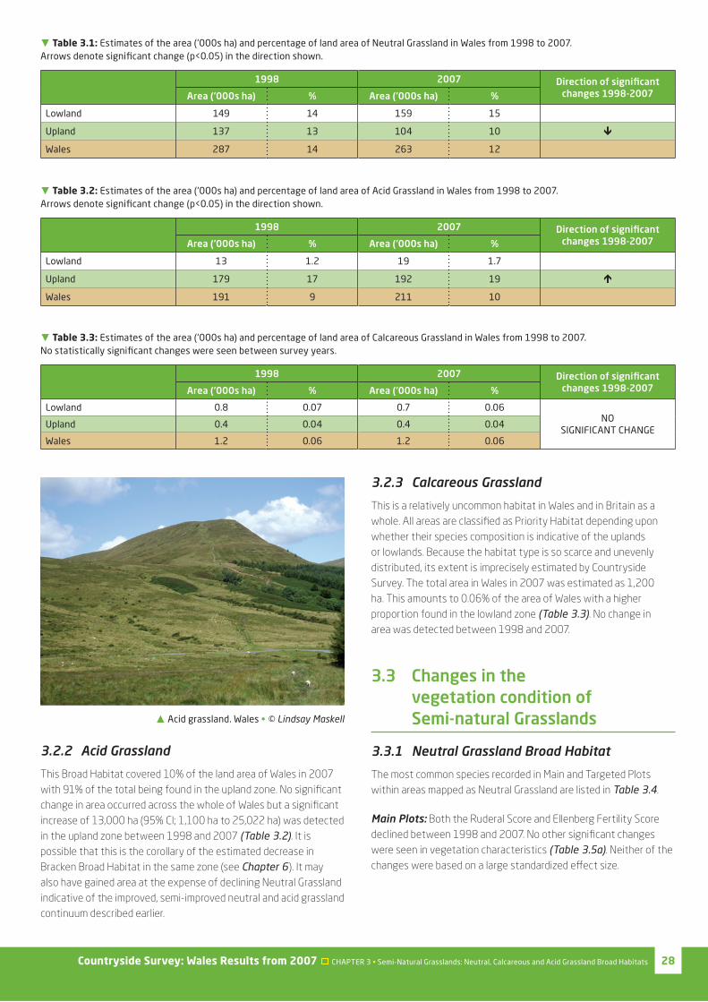
Of the three Broad Habitats, Neutral Grassland covered the largest area in 2007 estimated at 12% of the area of Wales with 60% of this being found in the lowland zone. Between 1998 and 2007 no signifi cant change in extent was identifi ed across Wales as a whole but a signifi cant decrease of 33,200 ha (95% CI: -1,964 ha to -53,127 ha) was detected in the upland zone although with a large confi dence interval (Table 3.1). This contrasts with an estimated increase of 163,000 ha (95% CI: 37,550 ha to 291,735 ha) in area in England, probably attributable to setaside associated with arable farming systems (setaside is far less common in Wales due to the small area of arable farming), and compares with an estimated 12.5% loss (33,000 ha) of Neutral Grassland in Northern Ireland in the same period26.
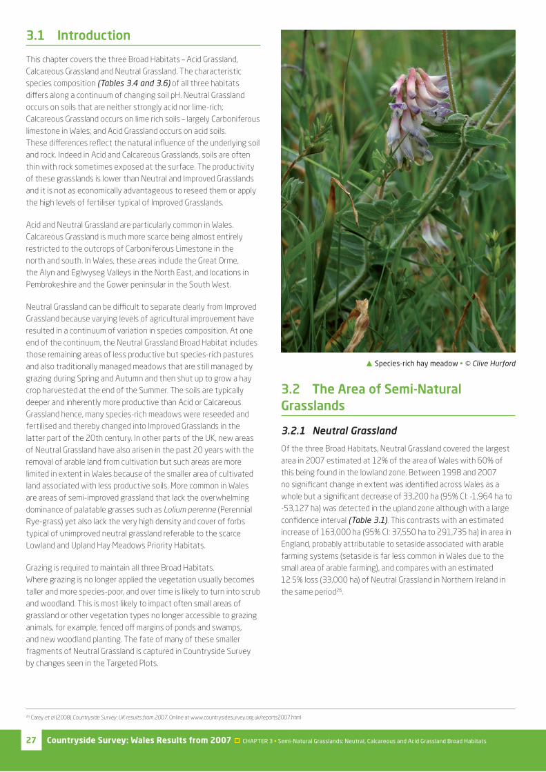
� Species-rich hay meadow • © Clive Hurford
26 Carey et al (2008) Countryside Survey: UK results from 2007. Online at www.countrysidesurvey.org.uk/reports2007.html
Countryside Survey: Wales Results from 2007 CHAPTER 3 • Semi-Natural Grasslands: Neutral, Calcareous and Acid Grassland Broad Habitats 28
3.2.2 Acid Grassland
This Broad Habitat covered 10% of the land area of Wales in 2007 with 91% of the total being found in the upland zone. No signifi cant change in area occurred across the whole of Wales but a signifi cant increase of 13,000 ha (95% CI; 1,100 ha to 25,022 ha) was detected in the upland zone between 1998 and 2007 (Table 3.2). It is possible that this is the corollary of the estimated decrease in Bracken Broad Habitat in the same zone (see Chapter 6). It may also have gained area at the expense of declining Neutral Grassland indicative of the improved, semi-improved neutral and acid grassland continuum described earlier.
3.2.3 Calcareous Grassland
This is a relatively uncommon habitat in Wales and in Britain as a whole. All areas are classifi ed as Priority Habitat depending upon whether their species composition is indicative of the uplands or lowlands. Because the habitat type is so scarce and unevenly distributed, its extent is imprecisely estimated by Countryside Survey. The total area in Wales in 2007 was estimated as 1,200 ha. This amounts to 0.06% of the area of Wales with a higher proportion found in the lowland zone (Table 3.3). No change in area was detected between 1998 and 2007.
3.3 Changes in the vegetation condition of Semi-natural Grasslands
3.3.1 Neutral Grassland Broad Habitat
The most common species recorded in Main and Targeted Plots within areas mapped as Neutral Grassland are listed in Table 3.4.
Main Plots: Both the Ruderal Score and Ellenberg Fertility Score declined between 1998 and 2007. No other signifi cant changes were seen in vegetation characteristics (Table 3.5a). Neither of the changes were based on a large standardized eff ect size.
� Table 3.1: Estimates of the area (‘000s ha) and percentage of land area of Neutral Grassland in Wales from 1998 to 2007. Arrows denote signifi cant change (p<0.05) in the direction shown.
1998 2007 Direction of signifi cant changes 1998-2007Area (‘000s ha) % Area (‘000s ha) %
Lowland 149 14 159 15
Upland 137 13 104 10 !Wales 287 14 263 12
� Table 3.2: Estimates of the area (‘000s ha) and percentage of land area of Acid Grassland in Wales from 1998 to 2007. Arrows denote signifi cant change (p<0.05) in the direction shown.
1998 2007 Direction of signifi cant changes 1998-2007Area (‘000s ha) % Area (‘000s ha) %
Lowland 13 1.2 19 1.7
Upland 179 17 192 19 ~Wales 191 9 211 10
� Table 3.3: Estimates of the area (‘000s ha) and percentage of land area of Calcareous Grassland in Wales from 1998 to 2007. No statistically signifi cant changes were seen between survey years.
1998 2007 Direction of signifi cant changes 1998-2007Area (‘000s ha) % Area (‘000s ha) %
Lowland 0.8 0.07 0.7 0.06NO
SIGNIFICANT CHANGEUpland 0.4 0.04 0.4 0.04
Wales 1.2 0.06 1.2 0.06
� Acid grassland. Wales • © Lindsay Maskell

Countryside Survey: Wales Results from 2007 CHAPTER 3 • Semi-Natural Grasslands: Neutral, Calcareous and Acid Grassland Broad Habitats29
� Table 3.5: Change in the characteristics of vegetation in a) 200m2 Main Plots and b) 4m2 Targeted Plots, in the Neutral Grassland Broad Habitat across Wales between 1990, 1998 and 2007. W=Wales, Lo=Lowland zone, Up=Upland zone. Arrows denote signifi cant change (p<0.05) in the direction shown. None of the signifi cant changes refl ected a large eff ect size.
a) Main PlotsMean values
(Wales)
Direction of signifi cant changes
1998 - 2007
Direction of signifi cant changes
1990 - 1998
Direction of signifi cant changes
1990 - 2007
Vegetation Condition Measures 1990 1998 2007 W Lo Up W Lo Up W Lo Up
Species Richness (No. of Species) 21.3 21.5 21.1 NO SIGNIFICANT
CHANGE
NO SIGNIFICANT
CHANGE
NO SIGNIFICANT
CHANGENo. of Bird Food Species 11.6 11.4 11
No. of Butterfl y Food Species 10.6 10.8 10.4
Grass:Forb Ratio 1.08 1.10 1.07
NO SIGNIFICANT
CHANGE
Competitor Score 2.75 2.79 2.77
Stress Tolerator Score 2.29 2.26 2.32
Ruderal Score 2.94 2.98 2.93 !Light Score 7.02 7.01 6.98
Fertility Score 5.00 4.99 4.83 ! ! !Ellenberg pH Score 5.79 5.72 5.61
Moisture Score 5.43 5.52 5.53
b) Targeted PlotsMean values
(Wales)
Direction of signifi cant changes
1998 - 2007
Direction of signifi cant changes
1990 - 1998
Direction of signifi cant changes
1990 - 2007
Vegetation Condition Measures 1990 1998 2007 W Lo Up W Lo Up W Lo Up
Species Richness (No. of Species) 15.8 18.3 15.5 ! ! ~ ~ NO SIGNIFICANT
CHANGENo. of Bird Food Species 6.1 7.5 6.2 ! ! ~ ~No. of Butterfl y Food Species 7.1 8.1 7 ! ! ~Grass:Forb Ratio 0.54 0.93 0.88 ~ ~Competitor Score 2.81 2.81 2.82
Stress Tolerator Score 2.58 2.48 2.45 ! !Ruderal Score 2.58 2.63 2.66
Light Score 6.89 6.91 6.91
Fertility Score 4.62 4.66 4.68
Ellenberg pH Score 5.64 5.54 5.55 ! !Moisture Score 5.99 6.07 5.89 ! !
� Table 3.4: Most frequent 15 species in 2007 in the Neutral Grassland Broad Habitat in Wales.
a) Main Plots (n=74) b) Targeted Plots (n=67)
% frequency Mean cover (%) Plant name % frequency Mean cover (%) Plant name
93 16 Holcus lanatus 84 12 Holcus lanatus
92 28 Agrostis capillaris 61 15 Agrostis capillaris
82 6 Trifolium repens 48 1 Rumex acetosa
81 1 Cerastium fontanum 46 9 Agrostis stolonifera
81 12 Lolium perenne 46 3 Lolium perenne
74 3 Ranunculus repens 46 3 Trifolium repens
72 1 Taraxacum agg. 45 3 Anthoxanthum odoratum
66 3 Anthoxanthum odoratum 43 6 Festuca rubra agg.
65 1 Rumex acetosa 42 1 Ranunculus acris
57 4 Cynosurus cristatus 40 2 Ranunculus repens
54 2 Ranunculus acris 37 3 Plantago lanceolata
50 5 Festuca rubra agg. 36 1 Cerastium fontanum
43 5 Agrostis stolonifera 34 2 Cynosurus cristatus
36 3 Juncus eff usus 33 1 Dactylis glomerata
35 1 Cirsium arvense 31 2 Juncus eff usus

Countryside Survey: Wales Results from 2007 CHAPTER 3 • Semi-Natural Grasslands: Neutral, Calcareous and Acid Grassland Broad Habitats 30
Targeted Plots: These plots focus on changes in the smaller fragments of habitat too small and uncommon to have been sampled by the randomly placed Main Plots. The only overall trend to be seen between 1990 and 2007 was an increase in Grass:Forb ratio. Species richness increased between 1990 and 1998 but decreased between 1998 and 2007. However, in no case were standardized eff ect sizes large so that all changes may have resulted in only minor ecological impacts on the vegetation (Table 3.5b).
3.3.2 Acid Grassland Broad Habitat
The most common species recorded in Main and Targeted Plots within areas mapped as Acid Grassland are listed in Table 3.6.
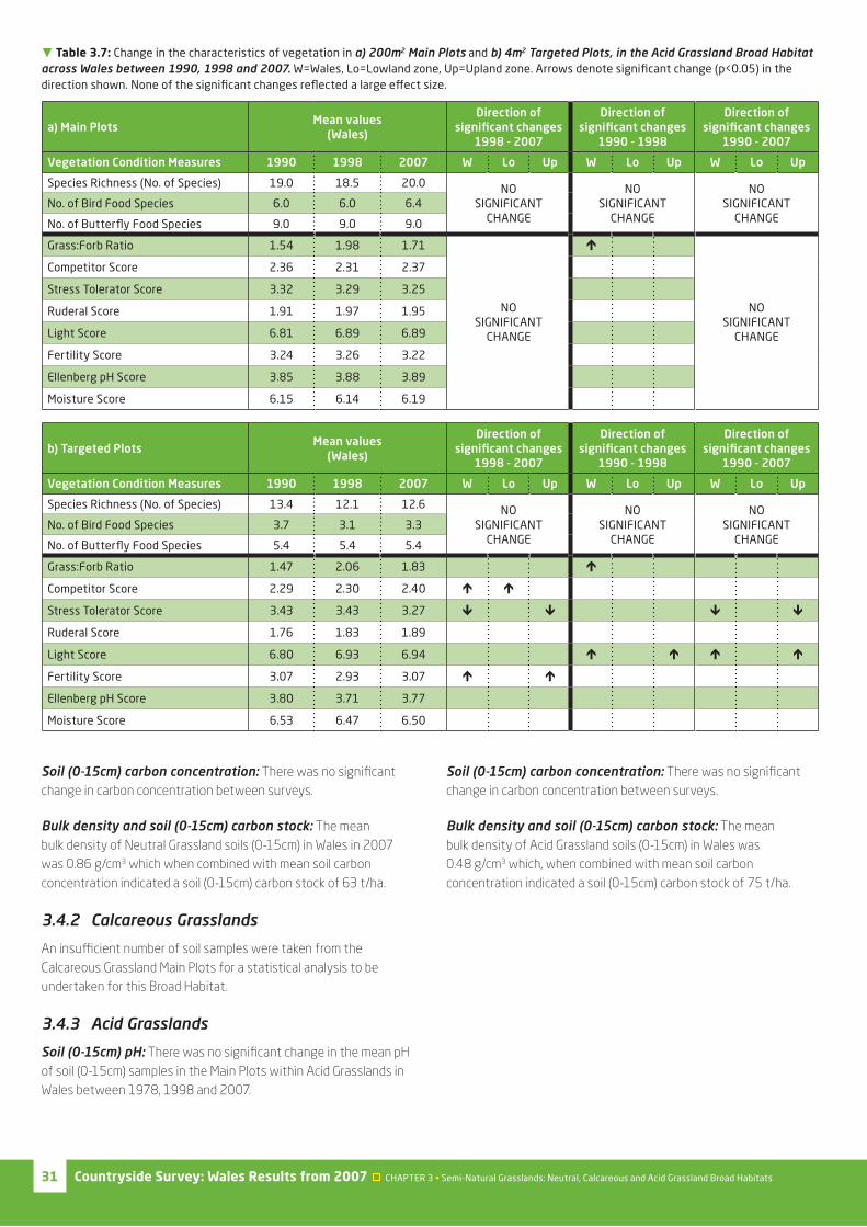
Main Plots: The only signifi cant change was an increase in Grass:Forb ratio between 1990 and 1998. The standardized eff ect size was not large suggesting possibly minor ecological impact on the vegetation structure (Table 3.7a).
Targeted Plots: A larger number of signifi cant changes were seen in the smaller Targeted Plots that pick out rarer fragments of habitat embedded within mapped areas of the Broad Habitat. Between 1998 and 2007, Ellenberg Fertility Score increased, Competitor Score increased and Stress-tolerator Score decreased. These changes were not seen between 1990 and 1998 where only Ellenberg Light Score and Grass:Forb ratio increased. Therefore over the 17 year period between 1990 and 2007, little net change had occurred with an overall reduction in Stress-tolerator Score and an increase in Ellenberg Light Score suggesting a minor increase in species of more open conditions (Table 3.7b). Again, none of the changes were based on large standardized eff ect sizes so that ecological impacts on the vegetation are likely to have been small relative to the variation in the sample although confi rmation requires further research.
3.3.3 Calcareous Grassland Broad Habitat
Too few plots were available for analysis of this habitat type.
3.4 Changes to the soils (0-15cm) of semi-natural grasslands
3.4.1 Neutral Grasslands
Soil (0-15cm) pH: The mean pH of soil (0-15cm) in Main Plots within Neutral Grassland in Wales increased signifi cantly between 1978 and 1998, and overall from 1978 to 2007 (Fig 3.1). The signifi cant increase in pH between 1978 and 1998 has not continued between 1998 and 2007. This is consistent with a response to decreased acid deposition during the earlier period of the survey and subsequent stabilisation. However, stronger support for a correlative link between the two awaits further analysis.
� Table 3.6: Most frequent 15 species in 2007 in the Acid Grassland Broad Habitat in Wales.
a) Main Plots (n=49) b) Targeted Plots (n=54)
% frequency Mean cover (%) Plant name % frequency Mean cover (%) Plant name
88 3 Galium saxatile 48 5 Festuca ovina agg.
80 6 Rhytidiadelphus squarrosus 48 14 Molinia caerulea
76 11 Festuca ovina agg. 48 3 Rhytidiadelphus squarrosus
71 13 Agrostis capillaris 44 1 Potentilla erecta
71 15 Nardus stricta 41 8 Agrostis capillaris
61 5 Vaccinium myrtillus 41 2 Galium saxatile
59 2 Anthoxanthum odoratum 37 3 Anthoxanthum odoratum
57 4 Juncus eff usus 37 2 Vaccinium myrtillus
55 22 Molinia caerulea 33 2 Deschampsia fl exuosa
53 3 Deschampsia fl exuosa 33 4 Nardus stricta
53 4 Juncus squarrosus 31 1 Luzula campestris/multifl ora
53 1 Luzula campestris/multifl ora 28 4 Calluna vulgaris
51 2 Potentilla erecta 28 2 Polytrichum commune
43 3 Polytrichum commune 26 3 Agrostis canina sens.lat.
41 1 Pleurozium schreberi 24 1 Festuca rubra agg.
� Figure 3.1: Change in soil pH in Neutral Grassland in Wales between 1978 and 2007. Error bars are the 95% confi dence intervals on mean soil pH in each survey year. Signifi cant change (at least p<0.05) occurred between 1978 and 2007, and 1978 and 1998.
4.5
4.7
4.9
5.1
5.3
5.5
5.7
5.9
6.1
6.3
6.5
1975 1980 1985 1990 1995 2000 2005 2010
Soil
pH
(0
-15
cm)
Countryside Survey: Wales Results from 2007 CHAPTER 3 • Semi-Natural Grasslands: Neutral, Calcareous and Acid Grassland Broad Habitats31
Soil (0-15cm) carbon concentration: There was no signifi cant change in carbon concentration between surveys.
Bulk density and soil (0-15cm) carbon stock: The mean bulk density of Neutral Grassland soils (0-15cm) in Wales in 2007 was 0.86 g/cm3 which when combined with mean soil carbon concentration indicated a soil (0-15cm) carbon stock of 63 t/ha.
3.4.2 Calcareous Grasslands
An insuffi cient number of soil samples were taken from the Calcareous Grassland Main Plots for a statistical analysis to be undertaken for this Broad Habitat.
3.4.3 Acid Grasslands
Soil (0-15cm) pH: There was no signifi cant change in the mean pH of soil (0-15cm) samples in the Main Plots within Acid Grasslands in Wales between 1978, 1998 and 2007.
Soil (0-15cm) carbon concentration: There was no signifi cant change in carbon concentration between surveys.
Bulk density and soil (0-15cm) carbon stock: The mean bulk density of Acid Grassland soils (0-15cm) in Wales was 0.48 g/cm3 which, when combined with mean soil carbon concentration indicated a soil (0-15cm) carbon stock of 75 t/ha.
� Table 3.7: Change in the characteristics of vegetation in a) 200m2 Main Plots and b) 4m2 Targeted Plots, in the Acid Grassland Broad Habitat across Wales between 1990, 1998 and 2007. W=Wales, Lo=Lowland zone, Up=Upland zone. Arrows denote signifi cant change (p<0.05) in the direction shown. None of the signifi cant changes refl ected a large eff ect size.
a) Main PlotsMean values
(Wales)
Direction of signifi cant changes
1998 - 2007
Direction of signifi cant changes
1990 - 1998
Direction of signifi cant changes
1990 - 2007
Vegetation Condition Measures 1990 1998 2007 W Lo Up W Lo Up W Lo Up
Species Richness (No. of Species) 19.0 18.5 20.0 NO SIGNIFICANT
CHANGE
NO SIGNIFICANT
CHANGE
NO SIGNIFICANT
CHANGENo. of Bird Food Species 6.0 6.0 6.4
No. of Butterfl y Food Species 9.0 9.0 9.0
Grass:Forb Ratio 1.54 1.98 1.71
NO SIGNIFICANT
CHANGE
~
NO SIGNIFICANT
CHANGE
Competitor Score 2.36 2.31 2.37
Stress Tolerator Score 3.32 3.29 3.25
Ruderal Score 1.91 1.97 1.95
Light Score 6.81 6.89 6.89
Fertility Score 3.24 3.26 3.22
Ellenberg pH Score 3.85 3.88 3.89
Moisture Score 6.15 6.14 6.19
b) Targeted PlotsMean values
(Wales)
Direction of signifi cant changes
1998 - 2007
Direction of signifi cant changes
1990 - 1998
Direction of signifi cant changes
1990 - 2007
Vegetation Condition Measures 1990 1998 2007 W Lo Up W Lo Up W Lo Up
Species Richness (No. of Species) 13.4 12.1 12.6 NO SIGNIFICANT
CHANGE
NO SIGNIFICANT
CHANGE
NO SIGNIFICANT
CHANGENo. of Bird Food Species 3.7 3.1 3.3
No. of Butterfl y Food Species 5.4 5.4 5.4
Grass:Forb Ratio 1.47 2.06 1.83 ~Competitor Score 2.29 2.30 2.40 ~ ~Stress Tolerator Score 3.43 3.43 3.27 ! ! ! !Ruderal Score 1.76 1.83 1.89
Light Score 6.80 6.93 6.94 ~ ~ ~ ~Fertility Score 3.07 2.93 3.07 ~ ~Ellenberg pH Score 3.80 3.71 3.77
Moisture Score 6.53 6.47 6.50
Countryside Survey: Wales Results from 2007 CHAPTER 3 • Semi-Natural Grasslands: Neutral, Calcareous and Acid Grassland Broad Habitats 32
3.5 The results in context
This chapter has considered three Broad Habitats that collectively represent much of the grassland resource within Wales; types not included here include those wetter forms, such as Purple-moor grass Meadows & Rush pastures, that fall within the Fen, Marsh & Swamp Broad Habitat, and the most intensively modifi ed forms that are dealt with in the Enclosed Farmland chapter. That said, two types considered here – Neutral and Acid Grassland – will include areas of vegetation subject to signifi cant agricultural modifi cation. Most of the Neutral Grassland especially but perhaps also some part of Acid Grassland recorded by Countryside Survey probably falls within the broad category of grasslands commonly referred to as semi-improved grassland. Very small amounts of the Neutral Grassland described here will relate to unimproved forms of high conservation value (these are a scattered, fragmented resource in Wales as elsewhere in the UK). Larger amounts of the Acid Grassland will correspond to forms that grade into Dwarf Shrub Heath and Bog in the unenclosed uplands, and probably very little to lowland unimproved Acid Grassland, a type of high nature conservation value that is scarce and highly localised in Wales.
None of the Welsh grassland types considered to be of high conservation interest within each of these three broad habitats, namely the Priority Habitats Lowland Hay Meadows, Lowland Dry Acid Grassland, Lowland Calcareous Grassland, and Upland Calcareous Grassland, is recorded suffi ciently often by Countryside Survey to enable assessment of its state.
With the exception of Neutral Grassland, Habitat Survey of Wales fi gures fall within the confi dence intervals of Countryside Survey estimates (Table 3.8). In the case of Neutral Grassland, there is a particularly large diff erence between the two surveys. But, as discussed in relation to Improved Grassland, the Countryside Survey defi nition of Neutral Grassland includes semi-improved types that Habitat Survey of Wales allocated to Improved Grassland (this may be the case also in relation to Acid Grassland, though perhaps to a lesser degree). Perhaps more than anything, this simply reinforces the diffi culty of drawing hard lines between classes of vegetation that in reality grade into one another. This is diffi cult in any single survey; drawing comparisons between surveys only compounds the diffi culties. It should also be recalled that neither Habitat Survey of Wales nor Countryside Survey used the Broad Habitat classifi cation as its primary means of description, and Broad Habitat estimates are derived by subsequent allocation of recorded types to Broad Habitats.
Key results and follow-up questions:
• No evidence of long-term change in species richness in either Neutral or Acid Grassland – what are the implications for the aim of halting biodiversity loss?
• Few long-term changes in condition of Acid and Neutral Grassland – how consistent is this apparent stability with changes in other habitats, and with biodiversity and/or agri-environment objectives?
• An increase in pH of surface soils under Neutral Grassland – is this part of a general trend of recovery?
These questions, together with those identifi ed in each of the other habitat chapters, are considered further in Chapter 9.
� Table 3.8: Comparative estimates of the semi-natural grassland habitat extent (‘000s ha) are available from the Habitat Survey of Wales. 95% CI on the Countryside Survey 2007 estimates are given in brackets.
Neutral Grassland Acid Grassland Calcareous Grassland
Countryside Survey (2007) 263 (214.8-317.8) 211 (136.3-330.0) 1 (>0-3.3)
Habitat Survey of Wales (1979 - 1997) 35 153 2
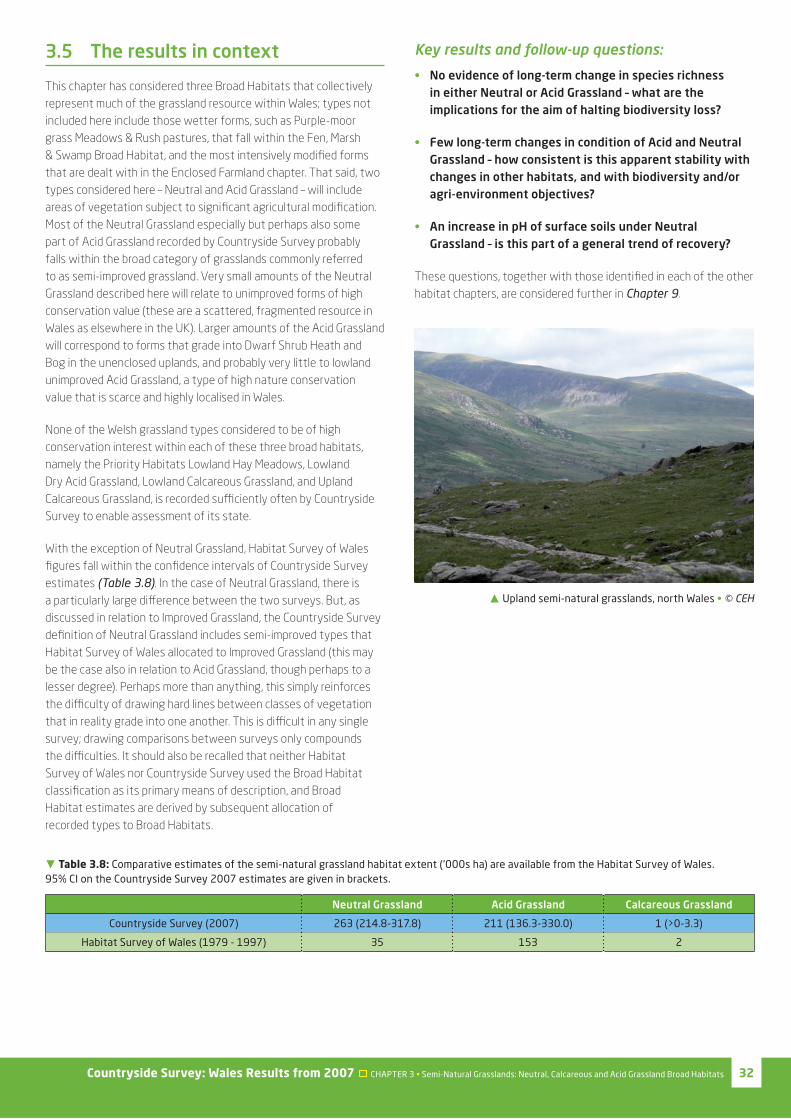
� Upland semi-natural grasslands, north Wales • © CEH
Countryside Survey: Wales Results from 2007 CHAPTER 3 • Semi-Natural Grasslands: Neutral, Calcareous and Acid Grassland Broad Habitats
Further information and future analysis
More details of the methodology, analyses and results from Countryside Survey can be found in other companion reports and data resources available from the Countryside Survey website.
This report for Wales is one of a suite of reports that have either already been published or are scheduled for publication in the next year or two. The UK results of Countryside Survey were published in November 2008, and this report is one of several country reports that are being produced in summer 2009.
More detailed analysis of particular components of the survey – soils, streams and ponds – will be reported later in 2009 in separate themed reports. A detailed, integrated assessment of Countryside Survey data alongside other datasets, exploring what the results mean for provision of selected ecosystem goods and services, will be reported in 2010. While these reports will make use of the fuller Countryside Survey dataset, rather than a single country dataset, the results will have considerable relevance for Wales. Rather than marking the end of our evaluation of what Countryside Survey results mean for the Welsh countryside, this current report only marks the beginning.
Reports:
• UK Headline Messages – published November 2008
• UK Results from 2007 – published November 2008
• Detailed Northern Ireland Countryside Survey results – published 2010
• England Results from 2007 – due to be published August 2009
• Scotland Results from 2007 – published 25th June 2009
• Ponds – due to be published Summer 2009
• Streams – due to be published October 2009
• Soils – due to be published November 2009
• Integrated Assessment – due to be published 2010
Data resources:
• Web access to summary data – a systematic summary of the results used to inform the UK and country level reports – launched in November 2008 and updated in January 2009
• Web access to the actual data – data from individual survey squares used to generate all the results presented in Countryside Survey reports from the 2007 survey – licensed access available from June 2009
• The UK Land Cover Map for 2007 – September 2009
The data generated by Countryside Survey will continue to be investigated in conjunction with other information such as climate, pollution and agricultural statistics. It is anticipated that future analysis of Countryside Survey data will lead to many scientifi c journal articles over the coming years. These investigations will improve understanding about the possible causes of the changes detected in the countryside and, for example, provide an opportunity to explore the results for Priority Habitats in more detail.
Contacts
For further information on Countryside Survey see www.countrysidesurvey.org.uk or contact: Countryside Survey Project Offi ce, Centre for Ecology and Hydrology, Lancaster Environment Centre, Library Avenue, Bailrigg, Lancaster LA1 4AP
Telephone: 01524 595811Email: [email protected]
COPYRIGHT: This publication is the Copyright of the Natural Environment Research Council, July 2009
Copyright: of all graphs, diagrams and charts is owned by the Natural Environment Research Council
Copyright of photographs: Copyright of photographs is as acknowledged in individual captions
Copyright enquiries should be addressed to: Knowledge Transfer Team, Centre for Ecology and Hydrology, Maclean Building, Benson Lane, Wallingford OX10 8BB
This publication, excluding logos, may be reproduced free of charge in any format or medium for research, private study or the purposes of internal use within an organisation. This is subject to it being reproduced accurately and not being subject to any treatment that could be considered derogatory. The reproduced material must be acknowledged as NERC Copyright (except where otherwise stated) and the publication named in full.
Disclaimer
Any decisions or actions informed by these results are taken entirely at your own risk. In no event shall NERC be liable for any damages, including loss of business, loss of opportunity, loss of data, loss of profi ts or for any other indirect or consequential loss or damage whatsoever arising out of the use of or inability to use the results presented in this report.
The Countryside Survey partnership has endeavoured to ensure that the results presented in this report are quality assured and accurate. Data has been collected to estimate the stock, change, extent and/or quality of the reported parameters. However, the complex nature of the experimental design means that results can not necessarily be extrapolated and/or interpolated beyond their intended use without reference to the original data.
This document has been design and optimised to be printed as portrait A4 double-sided pages.
When printing from the software application Adobe® Reader®, please use the ‘Fit to paper’ or ‘Shrink to
Printable Area’ options found in the ‘Page Scaling’ drop down menu of the ‘Print’ dialogue box.
Designed by Countryscape.